A GIS-Based Earthquake Damage Prediction in Different...
16
Key words: damage prediction, earthquake, earthquake loss scenario, GIS, UPLB A GIS-Based Earthquake Damage Prediction in Different Earthquake Models: A Case Study at the University of the Philippines Los Baños, Philippines 1 Department of Geological Engineering, Faculty of Engineering, Syiah Kuala University, Banda Aceh, Indonesia 2 School of Environmental Science and Management, University of the Philippines, Los Baños, Laguna, Philippines 3 Tsunami and Disaster Mitigation Research Center, Syiah Kuala University, Banda Aceh, Indonesia 4 Department of Civil Engineering, University of Philippines Los Baños, Laguna, Philippines 5 Department of Physics, Faculty of Sciences, Syiah Kuala University, Banda Aceh, Indonesia 6 College of Forestry and Natural Resources, University of the Philippines, Los Baños, Laguna, Philippines 7 LESTARI, Universiti Kebangsaan Malaysia (UKM), Selangor, Malaysia 8 Visvesvaraya National Institute of Technology, Maharashtra, India *Corresponding author: [email protected] Ibnu Rusydy 1,3, *, Decibel V. Faustino-Eslava 2 , Umar Muksin 3,5 , Richelle Gallardo-Zafra 4 , Jedidiah Joel C. Aguirre 4 , Nathaniel C. Bantayan 6 , Lubna Alam 7 , and Shruthi Dakey 8 The University of the Philippines Los Baños (UPLB) is located in an earthquake-prone region and there are numerous earthquake sources that can possibly cause an earthquake at any magnitude anytime. A study of the earthquake damage prediction in several earthquake magnitude and time scenarios in GIS model analysis has been conducted for the UPLB’s campus. This study aims to produce several scenarios of the earthquake models and an intensity map for UPLB’s campus; to determine the damage ratio of the buildings and its distribution in different earthquake scenarios; and to estimate the casualty in the UPLB’s community; as well as to validate the earthquake model with historical earthquakes in the Philippines. Data preparation included the earthquake scenario model using shallow crustal shaking attenuation to produce an intensity map on the bedrock and the surface after site coefficient correction. The earthquake model in different scenarios is generated from the West Valley Fault (with Segment IV as the assumed locus). The damage ratio in different types of buildings was calculated using fragility curves of buildings of the Philippines. Population data of each building in different occupancy times, damage ratios, and injury ratios is used to compute the number of the injured due to an earthquake. The results reveal that UPLB’s building are subject to intensity range of MMI (Modified Mercalli Intensity) 6.7-8.1 due to 6.1-7.7 Mw earthquake coming from different sources along the West Valley Fault. The worst event of an earthquake is 7.7 Mw from Segment IV, which can cause 32-51% damage to buildings and injure 12-24.6% of a building population in a daytime (2 PM) event and injure 8-158 students in a dormitory at 2 AM (nighttime). The validation process shows that the mean square error between the calculated intensity and the actual intensity in the Philippines is 0.35. Philippine Journal of Science 147 (2): 301-316, June 2018 ISSN 0031 - 7683 Date Received: 11 Aug 2017 301
-
Upload
truongthuan -
Category
Documents
-
view
216 -
download
0
Transcript of A GIS-Based Earthquake Damage Prediction in Different...

Key words: damage prediction, earthquake, earthquake loss scenario, GIS, UPLB
A GIS-Based Earthquake Damage Prediction in Different Earthquake Models: A Case Study at the
University of the Philippines Los Baños, Philippines
1Department of Geological Engineering, Faculty of Engineering, Syiah Kuala University, Banda Aceh, Indonesia
2School of Environmental Science and Management, University of the Philippines, Los Baños, Laguna, Philippines
3Tsunami and Disaster Mitigation Research Center, Syiah Kuala University, Banda Aceh, Indonesia4Department of Civil Engineering, University of Philippines Los Baños, Laguna, Philippines5Department of Physics, Faculty of Sciences, Syiah Kuala University, Banda Aceh, Indonesia
6College of Forestry and Natural Resources, University of the Philippines, Los Baños, Laguna, Philippines7LESTARI, Universiti Kebangsaan Malaysia (UKM), Selangor, Malaysia
8Visvesvaraya National Institute of Technology, Maharashtra, India
*Corresponding author: [email protected]
Ibnu Rusydy1,3,*, Decibel V. Faustino-Eslava2, Umar Muksin3,5, Richelle Gallardo-Zafra4, Jedidiah Joel C. Aguirre4, Nathaniel C. Bantayan6, Lubna Alam7
, and Shruthi Dakey8
The University of the Philippines Los Baños (UPLB) is located in an earthquake-prone region and there are numerous earthquake sources that can possibly cause an earthquake at any magnitude anytime. A study of the earthquake damage prediction in several earthquake magnitude and time scenarios in GIS model analysis has been conducted for the UPLB’s campus. This study aims to produce several scenarios of the earthquake models and an intensity map for UPLB’s campus; to determine the damage ratio of the buildings and its distribution in different earthquake scenarios; and to estimate the casualty in the UPLB’s community; as well as to validate the earthquake model with historical earthquakes in the Philippines. Data preparation included the earthquake scenario model using shallow crustal shaking attenuation to produce an intensity map on the bedrock and the surface after site coefficient correction. The earthquake model in different scenarios is generated from the West Valley Fault (with Segment IV as the assumed locus). The damage ratio in different types of buildings was calculated using fragility curves of buildings of the Philippines. Population data of each building in different occupancy times, damage ratios, and injury ratios is used to compute the number of the injured due to an earthquake. The results reveal that UPLB’s building are subject to intensity range of MMI (Modified Mercalli Intensity) 6.7-8.1 due to 6.1-7.7 Mw earthquake coming from different sources along the West Valley Fault. The worst event of an earthquake is 7.7 Mw from Segment IV, which can cause 32-51% damage to buildings and injure 12-24.6% of a building population in a daytime (2 PM) event and injure 8-158 students in a dormitory at 2 AM (nighttime). The validation process shows that the mean square error between the calculated intensity and the actual intensity in the Philippines is 0.35.
Philippine Journal of Science147 (2): 301-316, June 2018ISSN 0031 - 7683Date Received: 11 Aug 2017
301

INTRODUCTIONThe safety of a university is the most pressing need for students, lecturers, and university members. Universities have several types of buildings with different purposes (academic, services, administrative, and dormitory), some of which become more vulnerable compared to other buildings when an earthquake occurs. The Philippines experiences many destructive earthquakes in various parts of the country. One of the most remembered earthquakes is the 1990 Central Luzon earthquake with magnitude of Ms = 7.8 (Kojima et al. 1992; Wieczorek et al. 1992). Therefore, studying earthquake damage prediction in several scenarios becomes necessary to decrease the vulnerability and increase the capacity of the community in the future.
To study building damage prediction in several earthquake scenarios based on Geographic Information System (GIS) analysis, it is necessary to estimate the earthquake intensity in several scenarios of magnitudes and the source of the earthquake from the fault close to the study area. This earthquake intensity or ground shaking is the primary factor that causes building damage compared to liquefaction, landslide, and seismic bearing capacity (Cinicioglu et al. 2007). The second process is to evaluate the damage ratio based on the seismic performance in Modified Mercalli Intensity (MMI) of each building and the fragility curve in a different type of structures, which is proposed by Tingatinga and co-authors (2013). The third step in this study is to calculate the damage distribution and the number of damaged buildings from the damage ratio and buildings inventory data at the University of the Philippines Los Baños (UPLB).
Earthquake damage prediction using the systematic GIS method was proposed by Miura and co-authors (2008), Hashemi and Alesheikh (2011), and Karimzadeh and co-authors (2014). The method involved several geological data such as geological map, groundwater, sedimentological map, alluvial thickness, microtremor dataset, and earthquake catalog. For an earthquake scenario, deterministic seismic hazard analysis (DSHA) uses the ArcGIS toolset. Karimzadeh and co-authors (2014) argue that the DSHA method is accurate where the tectonic setting is reasonably active and well located. To estimate the building damage ratio, Karimzadeh and co-authors (2014) used the fragility curve in a different type of buildings as a function of MMI and they estimated the casualty ratio from historical earthquakes in the study area.
In the Philippines, numerous studies on earthquake engineering, including damage prediction, simulation, and site response, were carried out by several researchers. Torregosa and co-authors (2001) conducted a strong ground motion simulation technique based on seismic
hazard assessment that incorporates both historical earthquakes and active faults in the Philippines. The study successfully produced a peak ground acceleration (PGA) map of the Philippines in the expected event of 475-year recurrence (10% in 50 years) and occasional events of 100-year recurrence (39% in 50 years). The PGA map is a macrozonation map based on the acceleration in the bedrock; to build a microzonation map, one needs to determine the surface ground shaking. For Metro Manila, Miura and co-authors (2008) conducted earthquake damage estimation due to an earthquake scenario and estimated the seismic performance of a building based on an expert judgment. The damage ratio of the structure is calculated from the fragility curve that varies with each building, and the distributions of the destroyed buildings are calculated by considering the damage ratios and the building inventory.
In this study, the ArcGIS software was used to transform all parameters into actionable information. All parameters – such as geological map, amplification map based on standard penetrating test (SPT) data, several earthquake scenarios’ map in MMI, the fault map, and the type of building maps – are converted to shape files. All the maps were classified and used to calculate the damage ratio of UPLB’s buildings, damage distribution, and loss analysis.
Tectonics and Seismicity of the Study AreaThe Philippines is located in one of the most seismically active regions of Asia. Several significant and destructive earthquakes have occurred almost in every part of the country. The earthquake of 1990 in Central Luzon with magnitude of Ms 7.8 was the greatest earthquake for the people of the Philippines. The Philippines has many earthquake sources, such as the Philippine Trench, built by subduction of the western edge of the Philippine Sea Plate below the Eurasian Plate; this trench is the primary source of earthquakes and causes the Philippines to be classified as an earthquake-prone country (Kojima et al. 1992; Wieczorek et al. 1992; Torregosa et al. 2001). The trench extends from the south of Mindanao Island to Luzon Island in the north for a distance of about 1,400 km and is seismically active (Galgana et al. 2007). The other sources of earthquakes are the Philippine Fault Zone (PFZ), Manila Trench, and West Valley Fault System (WVFS), which roughly parallel the Philippine Trench.
The PFZ formed due to oblique convergence between the Philippine Sea Plate and the Eurasian Plate (Rowlett & Kelleher 1976; Besana & Ando 2005; Rimando & Knuepfer 2006). The PFZ is an active sinistral fault that extends from Mindanao to Luzon Island in a distance over 1,600 km long (Rimando & Knuepfer 2006). From the southeastern part of Luzon, the PFZ traverses into the Ragay Gulf zone and continues southeastward to the
Rusydy et al.: GIS-Based Earthquake Damage Prediction at UPLB
Philippine Journal of ScienceVol. 147 No. 2, June 2018
302

eastern part of Burias Island; approximately 10 major historical earthquakes occurred along this area (Rowlett & Kelleher 1976). Besana and Ando (2005) noted that the PFZ in Quezon transects to the west seaward of Ticao Island and then enters the southeastern Masbate Island; continuation of the PFZ is found on the island of Leyte along the same trend. The Luzon earthquake (1990) was the most destructive earthquake that occurred in the PFZ.
The Manila Trench is an active subduction zone caused by the penetration of the South China Sea plate beneath the northern Philippine Sea Plate. The 1,200-km-long Manila trench is associated with the east-dipping Benioff zone beneath Luzon (Hayes & Lewis 1985; Nguyen et al. 2014). In order to conduct tsunami modeling, Nguyen and co-workers (2014) introduced several models of seismic sources located along the Manila trench. Based on the model, an earthquake with magnitude of Mw 9.3 could occur along the Manila trench that could also cause high ground shaking.
However, the most devastating seismic source for the study area originates from the VFS. The VFS is the closest earthquake source to the study area at the distance in between 20-40 km. According to Rimando and Knuepfer (2006), VFS is a dextral (right lateral) strike-slip fault with a length of 130 km extending from the south of Canlubang to the Dingalan Bay in the north striking north-northeast (NNE). There are other sources of the earthquake (e.g., East Zambales fault) that can cause significant damage to the site but fault going to model its effects in future study.
Rimando and Knuepfer (2006) divided the VFS into two major fault systems: East Valley Fault System (EVFS) and WVFS. The WVFS is divided into four minor segments: Rodriguez-Taguig (segment I), Sucat-Binan (segment II), Binan-Sto. Domingo (segment III), and Pittland-Sungay (segment IV). The EVFS is divided into six segments: Umiray (segment V), San Mateo-Rodriguez (segment VI), Antipolo (segment VII), Angono (segment VIII), Binangonan (segment IX), and Talim Island (segment X) (Figure 1). Pittland-Sungay segment (IV) of WVFS and Talim Island segment of EVFS are the closest faults in the distance of about 20-30 km to this study area, and both segments were recognized as active faults by Rimando and Knuepfer (2006).
Nelson and co-authors (2000) predicted that the possible magnitude of the earthquake that will be produced in this fault system is approximately 6.8-7.1 Mw. Otherwise, Rimando and Knuepfer (2006) calculated the estimation magnitude in this fault system based on empirical relationships among surface displacement, rupture length, and magnitude within a range of 6.1-7.5 Mw (empirical relationship based on length) and in the range of 7.4-7.7 Mw (empirical relationship based on displacement).
The earthquake estimation of each segment is shown in Figure 1.
Several earthquake magnitude scenarios were considered with the termini of West Valley Fault and East Valley Fault (segments IV and X) as sources to produce a ground shaking model. The ground shaking or intensity is profoundly influenced by local geological characteristic or site coefficient. Different site coefficients will produce different site responses to the earthquake, and this is based on soil properties/geotechnical conditions underlying buildings (Akin et al. 2011; Mohamed et al. 2013; Fabbrocino et al. 2015; Rusydy et al. 2017).
METHODOLOGYGIS-based earthquake damage prediction is a method to develop damage estimation including infrastructure and human in different earthquake scenarios. In this study, the earthquake model in several scenarios is scrutinized
Figure 1. The Valley Fault System (VFS) and its segments are directly north of the UPLB campus (black rectangle). The VFS fault map is modified from Rimando and Knuepfer (2006), while the digital elevation model dataset is from NASA 2007.
Rusydy et al.: GIS-Based Earthquake Damage Prediction at UPLB
Philippine Journal of ScienceVol. 147 No. 2, June 2018
303

very well and refers to the previous neotectonic and paleoseismic studies of Nelson and co-authors (2000) and Rimando and Knuepfer (2006). The ground shaking or intensity scenario is developed using new global shaking attenuation for shallow and near earthquake equation, which was proposed by Allen and co-authors (2012).
Figure 2. The flowchart of earthquake damage prediction in several earthquake scenarios.
Damage estimation of several types of buildings is calculated based on the fragility curve for different buildings. In the present, the Philippines has developed a fragility curve in a different type of buildings as a function of the intensity of the earthquakes in MMI; these fragility curves were developed by Tingatinga and co-authors (2013). The steps of this study are shown in Figure 2 and the details of the methodology of this study – including data preparation, earthquake scenario, building damage assessment analysis, and casualty estimation – will be explained in detail in this section.
Data PreparationGIS analysis for earthquake damage prediction needs several shape file data to be input into the GIS software. The tectonic map of Philippines obtained from Bautista and Oike (2000) and the detail of Valley Fault System gathered from Rimando and Knuepfer (2006) are digitized using ArcGIS software and overlaid with Shuttle Radar Topography Mission (SRTM) map from NASA 2007, as shown in Figure 1. The location of active fault segments and magnitude estimates are key parameters in developing the earthquake sources scenarios to be used in the modeling (see section 3.2).
Earthquake ScenarioSeismology has been well developed, especially in the study of shaking attenuation in earthquake scenarios and models. Shaking attenuation is an empirical approach to determine ground motion in PGA and intensity of the earthquake in MMI. Intensity values derived from this approach are useful tools for the rapid and efficient communication of information on earthquake hazards and risks to the public and media (Allen et al. 2012). Dowrick
and Rhoades (2005) developed an empirical model of shaking attenuation in intensity for New Zealand. Atkinson and Wald (2007) created an online survey that was used by USGS to determine intensity data. Different tectonic settings have different shaking attenuations. The choice of the type of shaking attenuation applied in the study depends on the similarity of tectonic settings, geological characteristics, and the source of the earthquake.
In this study, the researchers used the shaking attenuation that was developed by Allen and co-authors (2012) to produce earthquake intensity maps from different magnitude-source scenarios (see Figure 3). This attenuation model estimates intensities due to an earthquake with hypo central depths of less than approximately 20 km and magnitudes of 5-7.9 Mw. It is therefore applicable to many earthquake generating geologic structure in the Philippines. Called the Intensity Prediction Equations (IPEs; Allen et al. 2012), the attenuation model was developed using 13,077 earthquakes around the world since 1973. Of these earthquakes, 1,613 are from Asian countries and include historical earthquakes that occurred in the Philippines. Equation (1) is used to estimate the intensity of the earthquake at a distance from the rupture zone. Equation 2 was proposed by Cinicioglu and co-authors (2007) and is used to compute the site amplification effect.
(1)
(2)
In the above equations, I stands for intensity in MMI, M stands for magnitude of the earthquake in Mw, Rrup stands for the distance to the rupture zone in km, c is a coefficient number (c0 = 3.950, c1 = 0.913, c2 = −1.107, and c3 = 0.813), S is the site correction, and F is the site amplification (Fv for a long period, Fa for a short period) representing the amplification capacity of the local soil.
Using equation (1), the researchers were able to generate the intensity map model of several earthquake scenarios in different rupture zones and magnitude estimation (Figure 3). Rusydy and co-authors (2017) used equation (1) to produce the intensity model in the Philippines. For the purpose of this study, the researchers assume the segments closest to the site, segments IV and X, as the loci of earthquakes along the West Valley fault and the East Valley Fault, respectively. Three scenarios involve segment IV of the West Valley fault as the assumed locus of earthquakes with magnitudes 7.7 Mw (Scenario 1), 7.2 Mw (Scenario 2), and 6.1 Mw (Scenario 3). Segment X (Talim Island) fault is chosen as the source of the
Rusydy et al.: GIS-Based Earthquake Damage Prediction at UPLB
Philippine Journal of ScienceVol. 147 No. 2, June 2018
304

Figure 3. Intensity map (MMI) from several earthquake scenarios without any site correction: (a) intensity map of a 7.7 Mw magnitude earthquake from WMVF with Segment IV as the rupture zone, (b) 7.2 Mw magnitude earthquake from WMVF with Segment IV as the rupture zone, (c) 6.1 Mw magnitude earthquake from WMVF with Segment IV as the rupture zone, and (d) 6.5 Mw magnitude earthquake from EMVF with Segment X as the rupture zone. Digital elevation model dataset is from NASA 2007.
earthquake for Scenario IV with a magnitude of 6.5 Mw. The magnitude estimates are based on segment lengths and single-event scarp displacements determined by Rimando and Knuepfer (2006) (Figure 1). Segments IV and X are geometric segments and are not necessarily equivalent to rupture segments. In other words, the whole of WMVF and the EMVF are the more likely sources of earthquakes. Rimando and Knuepfer (2006) clearly state the distinction between these types of segment. This study merely assumes that earthquakes shall occur along the segments that are closest to the site. Making the segments of the WVF and EVF that are closest to the site (Segment IV and X) as earthquake loci minimizes underestimation of intensity estimates.
Site Coefficient AnalysisThe intensity of earthquake produced from the earthquake scenario model is intensity in the bedrock without any consideration of the site coefficient or site amplification. The Site coefficient, site characteristic, and shear modulus (Gmax) of the soil can be accurately determined from the shear wave velocity (Vs). However, that parameter can also be estimated from SPT, cone penetrating test, dilatometer test (DMT), and pressuremeter test (PMT) (Akin et al. 2011). Because the Vs data is not available in UPLB’s campus, this study used the N-SPT and directly performed classification based on soil classification in ASCE/SEI 7-10 (2010). The amplification factor or the site coefficient (Fa for short periods and Fv for 1-second periods) represents the amplification capability of
Rusydy et al.: GIS-Based Earthquake Damage Prediction at UPLB
Philippine Journal of ScienceVol. 147 No. 2, June 2018
305

the local soils with regard to uniform ground condition. The values of Fa and Fv are from ASCE/SEI 7-10 (Minimum Design Loads for Buildings and Other Structures) (2010) while the PGA values (from 0.2 to 0.4) are from the PGA maps of Torregosa and co-authors (2001) and Aguirre (2013). Table 1 shows the N-SPT data and amplification values for UPLB Campus’ soil. For this study, SE is considered for two reasons: first, the obtained borehole logs do not represent the soil in the site since the depth of the boreholes does not reach 30 m; second, the results will yield more conservative results. However, the researchers used the N-SPT data as the assuming that the UPLB campus consists of pyroclastic deposit and assume almost homogeny.
Earthquake Damage Prediction AnalysisThe UPLB is located at a distance of 16-24 km from Segment X of EVFS and Segment IV of WVFS (Figure 4), respectively. The earthquakes from these fault
Figure 4. (a) The type of building in UPLB’s campus and the location of the N-SPT borehole. (b) The N-SPT data in UPLB’s campus from Campus Planning and Development Office (CPDO) in Cantos (2015). Digital elevation model dataset is from National Mapping and Resource Information Authority (NAMRIA) of the Philippines.
segments are assumed to be shallow crustal earthquakes and therefore, will have tremendous impact in terms of casualties and damage to buildings (Allen et al. 2012). The resistance of buildings to ground shaking, which varies from one area to another (and from one country to another), will affect the damage, injury, and mortality ratios (Rusydy et al. 2017). To estimate the damage ratio different type of building in the Philippines, Tingatinga and co-authors (2013) developed vulnerability curve or fragility curve based on the ground shaking in MMI. They developed the fragility curve using an analytic method (using nonlinear static pushover), empirical method (post-earthquake visual surveys and damage report), heuristic method (based on expert opinion and judgment), and hybrid approach for the types of buildings of the Philippines. The type of building in the research of Tingatinga and co-authors (2013) was typically similar to that proposed by FEMA (2010). The fragility curve will show the damage ratio of the structures on a scale of 0 to 1 against the ground shaking (Tingatinga et al. 2013). In this study, the researchers used the fragility curve designed by Tingatinga and co-authors (2013) in different types of buildings in UPLB’s campus, because this fragility curve is developed for the buildings in the Philippines and is more comprehensive (Figure 5).
Table 1. Site coefficient (Fv and Fa) for five different soil classifications based on ASCE/SEI 7-10 (2010) for PGA map 0.4 g.
Site Class SA SB SC SD SE
N-SPT NA NA >50 15 to 50 <15
FaFv
0.800.80
1.001.00
1.201.40
1.401.60
1.722.40
Rusydy et al.: GIS-Based Earthquake Damage Prediction at UPLB
Philippine Journal of ScienceVol. 147 No. 2, June 2018
306

Figure 5. Fragility curve of four types of buildings in the study area as a function of intensity in MMI (Tingatinga et al. 2013).
An inventory and classification of UPLB buildings were conducted by Valino (2014) and Arellano (2016). They listed 67 buildings in UPLB’s lower campus and classified them into two types: (1) low-rise concrete moment frame (C1-L) and (2) medium-rise concrete moment frame (C1-M). The researchers updated the inventory building data from 67 to 145 buildings from Valino (2014) and Arellano (2016). This study found 145 buildings in UPLB’s lower campus and all those buildings were divided into three categories: (1) low-rise concrete moment frame (C1-L), (2) medium-rise concrete moment frame (C1-M), and (3) low-rise light wood frame (W1-L). The distribution of the buildings in UPLB’s lower campus is shown in Figure 4(a). To determine the damage ratio in a different type of building, the fragility curve in Figure 5 will be used, which depends on the intensity response of each building in UPLB.
The damage ratio of each building will yield a different casualty number because of the people trapped in the collapsed or heavily damaged buildings (Hashemi & Alesheikh 2011). The primary factor of casualty of an earthquake is building collapse, taking into account about 75% casualty (Coburn & Spence 2002). The estimation of building casualty from one earthquake to another is difficult. For one, the documented casualty data is inadequate. In most cases, available data show a wide range in the number of casualties. There are many
equations used to calculate the casualty ratio; in this study, the researchers used the equation (3) proposed by Hashemi and Alesheikh (2011).Injured = Occupancy ratio x population x damage ratio x injury ratio. (3)
In nighttime, the occupancy ratio is assumed as 1 for dormitories because all students are in the dormitory at this time and is considered as 0 for academic, services, and administrative buildings. The researchers have census data of the student population in the dormitories, but for academics, services, and administrative buildings, they were unable to access the data. The computation of the maximum occupant capacity method that was proposed by the NBCP (2004) can be used in consideration of peak population condition, but this computation method had uncertainties. To avoid these, it was assumed that the population in all offices in the building as 100% and the casualty or injury estimate result will be in percent (%).
Currently, there are a few studies on the relationship between the type of building and the number of mortalities and injuries in the Philippines. However, there is an online report published by the Centers for Disease Control and Prevention (CDC) (1990). The report examined the casualty in several cities after the Luzon earthquake in 1990, which was gathered by the Philippines Field Epidemiology Training Program (FETP). In Baguio city, the report noted that 28 buildings, 132 residences, 3 hotels, and 2 schools collapsed due to Luzon earthquake. FETP
Rusydy et al.: GIS-Based Earthquake Damage Prediction at UPLB
Philippine Journal of ScienceVol. 147 No. 2, June 2018
307

Table 2. The population of the students in a dormitory in UPLB. The data was gathered from the Programmatic Environmental Performance Report and Management Plan (PEPRMP 2014) and Rusydy et al. (2017).
No. Dormitories Population Source of Data
1. Men's Residence Hall 646 PEPRMP 2014
2.Women's Residence
Hall444 PEPRMP 2014
3.Veterinary Medicine
Residence Hall376 Rusydy et al. (2017)
4. New Dormitory 294 Rusydy et al. (2017)
5. ACCI 90 PEPRMP 2014
6.SEARCA Residence
Hotel90 Rusydy et al. (2017)
7. ATI-NTC 126 Rusydy et al. (2017)
8. International House 124 PEPRMP 2014
Table 3. A worst-case scenario of injury ratio for different types of buildings proposed by Hashemi and Alesheikh (2011).
No. Type of Building Injury Ratio
1. RC Building > 4 stories (C1-M) 0
2. RC Building < 4 stories (C1-L) 0.2
3. Timber Frame Building (W1-L) 0.4
estimated the injury rate in Baguio City to be 703/100,000 or 0.7% of the population and estimated the mortality rate as 252/100,000 or 0.252%. The FETP also collected the casualty data in Cabanatuan, Dagupan, and La Union, but the injury and mortality rates were less than in Baguio city. A worst-case scenario for injury and mortality ratios in different types or buildings was developed by Hashemi and Alesheikh (2011) in Tehran, Iran, which is more vulnerable to damage. Although the injury ratio is very high, it will be adjusted by the value of damage ratio and value of occupancy ratio. This injury ratio will be applied to calculate the casualty ratio in this study as shown in Table 3, and this ratio will be the worst-case scenario of building damage and the number of injuries.
RESULTS
Earthquake Scenario for UPLB’s Lower CampusEarthquake damage in UPLB campus were predicted under four different earthquake scenarios and at two assumed periods of earthquake occurrence. The earthquake scenarios shown in Figure 3 did not consider site coefficient. Using Equation (2), the researchers calculated the site coefficient for use as equation (1) input to determine the surface intensity. According to ASCE/SEI 7-10 (2010), PGA is 0.4 and soil type will produce a site coefficient of 1.72. The calculated values for equations (1) and (2) are shown in Table 4.
Scenarios I-III assume earthquake centered along the southernmost segment of WVF (Segment IV), while scenario IV assumed an earthquake event centered along the southernmost segment of EVF (Segment X). Scenario I is the worst-scenario for UPLB, with a magnitude of 7.7 Mw event producing an intensity about 8.1. Though scenarios II and IV different earthquake magnitude is assumed, these generate similar intensity (i.e., 7.7 and 7.6 MMI) because of the shorter distance between segment IV and UPLB campus. The weakest intensity (6.7 MMI) happens in scenario III, which assumes a magnitude of only 6.1 Mw.
In this study, the site coefficient or amplification factor of 1.72 is considered similar in the entire building. This consideration due to all the N-STP data shown the similarity value and geologically, UPLB campus consist of pyroclastic deposit and assume almost homogeny. GIS is used in superimposing the intensity map model (figure 3) over the site coefficient map.
Damage Estimation and Distribution of UPLB BuildingsGIS analysis revealed that a magnitude of 7.7 Mw in Scenario I will result in a building damage ratio in the range of 0.32-0.51 ratio or equal to 32-51% at UPLB’s lower campus. Damage value of 51% influences low-rise concrete moment frame (C1-L) buildings, 47% to low-rise light wood frame (W1-L) buildings, and 32% to medium-rise concrete moment frame (C1-M) buildings.
In Scenario II, an earthquake with a magnitude of 7.2 Mw will cause building damage in the range of 20-41%, with C1-M, C1-L, and W1-L experiencing 21%, 39%, and 41%
Table 4. Earthquake scenarios and ground shaking response in the bedrock and surface for UPLB’s campus.
Earthquake Scenario Magnitude (M) Distance (Rrup) Intensity at Bedrock S Intensity at Surface
I 7.7 Mw 24 Km 7.3 0.82 8.1
II 7.2 Mw 24 Km 6.9 0.82 7.7
III 6.1 Mw 24 Km 5.9 0.82 6.7
IV 6.5 Mw 16 Km 6.8 0.82 7.6
Rusydy et al.: GIS-Based Earthquake Damage Prediction at UPLB
Philippine Journal of ScienceVol. 147 No. 2, June 2018
308

of damage. In Scenario III, 6.1 Mw earthquake will cause 4-27% damage to UPLB’s buildings. C1-M, C1-L, and W1-L will incur 4%, 16%, and 27% of damage respectively. The damage ratios for the building in scenario IV (18-39%) are almost similar to those in Scenario II. A Scenario IV earthquake will cause 18% damage to C1-M buildings, 36% damage to C1-L buildings, and 39% damage to W1-L buildings. The distribution of the damage to buildings in several earthquake scenarios is shown in Figure 6.
Human Injury Estimation at UPLB’s Campus
In loss assessment analysis, all parameters (population, damage ratio, and intensity) are determined precisely. Without any detailed knowledge of how building respond to ground shaking at different periods, these methods could potentially add more uncertainty in loss estimate (Allen et al. 2012). The injury estimation for the four earthquake scenarios will be done for two different times of the day (2 PM and 2 AM). FEMA (2010) suggested using three different times (2 PM, 5 PM, and 2 AM), but this study lumped 2 PM and 5 PM together, as the university will still have activities until 5 PM.
Figure 6. Distribution of damage ratio of UPLB’s buildings in several earthquake scenarios: (a) Scenario I, (b) Scenario II, (c) Scenario III, and (d) Scenario IV. Digital elevation model dataset is from the National Mapping and Resource Information Authority (NAMRIA) of the Philippines.
Rusydy et al.: GIS-Based Earthquake Damage Prediction at UPLB
Philippine Journal of ScienceVol. 147 No. 2, June 2018
309

Injury Prediction in Daytime (2 PM) Daytime at 2 PM is a busy time during the day, and at this specific time, many students are in their classes and the administrative personnel are in their offices. GIS analysis using an attribute table is applied to calculate the number of injuries using formula (3) in this time scenario. The result shown in Figure 7 concludes that if the students and staff have no quick response and adequate access to an evacuation zone, this condition will injure 9.8% of the students or officers in C1-L buildings, 0% in C1-M buildings, and 18.8% in W1-L buildings in Scenario I earthquake.
In Scenario II, 7.8% are predicted to be injured in C1-L buildings, 0% in C1-M buildings, and 16.4% in W1-L buildings. Scenario III will cause less injury; in this scenario, only 3.2% will be injured in C1-L buildings, 0% in C1-M buildings, and 10.8% in W1-L buildings. In Scenario IV, the intensity of the earthquake is predicted to be 7.6 and this will injure 7.2% in C1-L buildings, 0% in C1-M buildings, and 15.6% in W1-L buildings. This is a relatively high percentage of injury as the students and the personnel of UPLB have no adequate capacity to evacuate the buildings. To minimize vulnerability, the authorities of UPLB have to increase the capacity
Figure 7. Percentage of injury in each building; an earthquake occurs at 2 PM in several scenarios: (a) Scenario I, (b) Scenario II, (c) Scenario III, and (d) Scenario IV. Digital elevation model dataset is from the National Mapping and Resource Information Authority (NAMRIA) of the Philippines.
Rusydy et al.: GIS-Based Earthquake Damage Prediction at UPLB
Philippine Journal of ScienceVol. 147 No. 2, June 2018
310
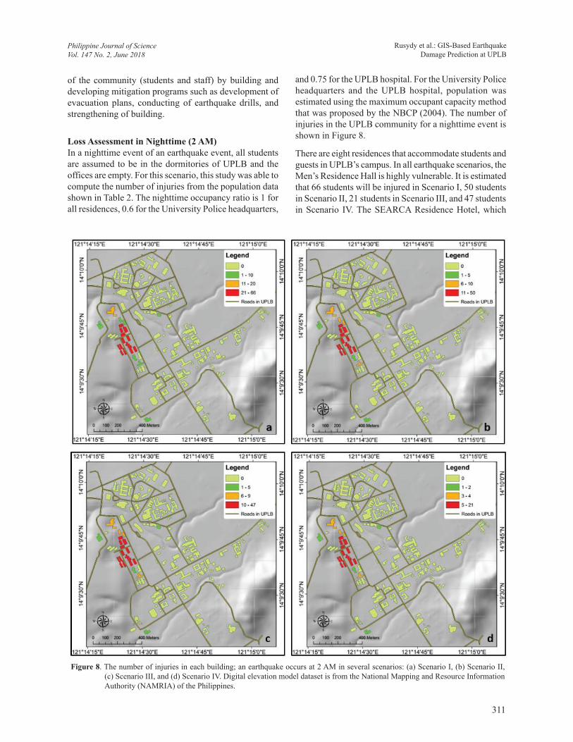
Figure 8. The number of injuries in each building; an earthquake occurs at 2 AM in several scenarios: (a) Scenario I, (b) Scenario II, (c) Scenario III, and (d) Scenario IV. Digital elevation model dataset is from the National Mapping and Resource Information Authority (NAMRIA) of the Philippines.
of the community (students and staff) by building and developing mitigation programs such as development of evacuation plans, conducting of earthquake drills, and strengthening of building.
Loss Assessment in Nighttime (2 AM)In a nighttime event of an earthquake event, all students are assumed to be in the dormitories of UPLB and the offices are empty. For this scenario, this study was able to compute the number of injuries from the population data shown in Table 2. The nighttime occupancy ratio is 1 for all residences, 0.6 for the University Police headquarters,
and 0.75 for the UPLB hospital. For the University Police headquarters and the UPLB hospital, population was estimated using the maximum occupant capacity method that was proposed by the NBCP (2004). The number of injuries in the UPLB community for a nighttime event is shown in Figure 8.
There are eight residences that accommodate students and guests in UPLB’s campus. In all earthquake scenarios, the Men’s Residence Hall is highly vulnerable. It is estimated that 66 students will be injured in Scenario I, 50 students in Scenario II, 21 students in Scenario III, and 47 students in Scenario IV. The SEARCA Residence Hotel, which
Rusydy et al.: GIS-Based Earthquake Damage Prediction at UPLB
Philippine Journal of ScienceVol. 147 No. 2, June 2018
311

accommodates 90 guests, and the New Dormitory are the safer places to stay. In the UPLB hospital, the maximum number of medical patients, doctors, staff, and relatives of patients is predicted to be 100 people, and at nighttime, this population is expected to decrease. The predicted number of injured people is five in scenario I, four in scenario II, two in scenario III, and four in scenario IV.
Earthquake Model Validation from Historical EarthquakesThe accuracy of the earthquake model is the main factor for earthquake damage prediction and it should be validated with historical earthquakes in the region. The earthquake model is very sensitive to the earthquake magnitude and the shaking attenuation equation and it has to be validated. The Philippines hosts numerous large-magnitude shallow crustal earthquakes. The IPEs equation proposed by Allen and co-authors (2012) was used in this study in developing earthquake scenarios. Because of this condition, one has to validate these IPEs by shallow
Figure 9. Rupture zone of 1990 Luzon earthquake and Intensity map produced using IPEs. The rupture zone is after Punongbayan and co-authors (2001). Digital elevation model dataset is from NASA 2007.
crustal historical earthquakes in the Philippines. The most memorable and destructive shallow crustal earthquake is 1990 Luzon earthquake (Figure 9).
The Luzon earthquake occurred on 16 Jul 1990 in the central part of Luzon Island, Philippines. This earthquake had a magnitude (Ms) of 7.8 and occurred along a shallow crustal active fault. This earthquake had a left-lateral strike-slip source mechanism. The ground rupture had a length of 120 km. At least 1,283 people were killed due to the collapse of multistory buildings (Wieczorek et al. 1992; Punongbayan et al. (2001). According to Kojima and co-authors (1992) and Ohmachi and Nakamura (1992), the major cause of the damage was associated with ground shaking, liquefaction, and poor building quality. Kojima and co-authors (1992) recorded that different cities respond with different intensities of the ground shaking and this depends on the site coefficient and distance to the rupture zone. Kojima and co-authors (1992) investigated the Rossi-Forel intensity scale and noted that Baguio city
Rusydy et al.: GIS-Based Earthquake Damage Prediction at UPLB
Philippine Journal of ScienceVol. 147 No. 2, June 2018
312

experienced VIII-IX intensity, Agoo and Dagupan city experienced VIII intensity, and Cabanatuan and Tarlac experienced VI-VIII intensity.
According to Ohmachi and Nakamura (1992), Baguio City has an amplification factor (Fv) in the range of 3-7, with an average of 5. This amplification factor is derived from microtremor measurement around Baguio City. In Dagupan City, Ohmachi and Nakamura (1992) found the amplification to be in the range of 1-4, with an average of 3. In Agoo City, they measured 18 points of microtremor and from the measurement, they found that the amplification factor in Agoo city was in the range of 2-8, with an average of 4.
Table 5 shows the comparison between the calculated MMI using IPEs and the intensities obtained by Kojima and co-authors (1992). The intensities obtained by Kojima and co-authors (1992) are given in terms of the Rossi-Forel intensity scale and are converted as MMI intensity units. The Rossi-Forel intensity scale is the first seismic intensity scale and is still used in the Philippines. This scale ranges from I (microseismic shock) to X (shock of extreme intensity), while the MMI intensity scale is from I (not felt) to XII (total destruction). Intensity IX of the Rossi-Forel scale will cause partial or total destruction of some buildings, fissures in the ground, landslides, and rock falls. It is equal to intensity X of MMI where some well-built wooden buildings and most masonry and frame structures with foundations were destroyed. On the other
Table 5. The earthquake intensity comparison between IPEs calculation and actual intensity in the Rossi-Forel scale.
City Distance to Rupture (Rrup)
Intensity at Bedrock(IPEs)
Amplif. (Fv) SIntensity at
SurfaceIn MMI (IPEs)
Actual Intensity at Surface(Kojima et al. 1992)
Rossi-Forel scale MMI
Baguio 39 Km 6.9 7 2.9 9.8 8-9 8-11
Cabanatuan 25 Km 7.4 1.5 0.6 8.0 6-8 6-9
Dagupan 62 Km 6.5 4 2.1 8.6 8 8-9
Agoo 58 Km 6.5 4 2.1 8.6 8 8-9
hand, intensity VI of the Rossi-Forel scale is similar to VI MMI. It is characterized by ringing of bells, stopping of clocks, visible agitation of shrubs and trees, moving of some heavy furniture, a few instances of fallen plaster, and slight damage to very old or poorly built structures. The mean square error between the calculated intensity and the actual intensity using IPEs in the Philippines is 0.35.
In term of damage, the 16 Jul 1990 Luzon Earthquake caused many damaged building along the city close to the earthquake source. The damage ratio yield in this study refers to the fragility curve developed by Tingatinga and co-authors (2013). The researchers validated their model intensity and the damage ratio model with the actual data of Luzon earthquake. The damage building information of 1990 Luzon earthquake has been archived well. Booth and co-authors (1991) has reported the visual damage of building (photos) each effected zone. These photos used to classify the structural damage of building. The visual classification of structural damage refers to Okada and Takai (2000). The result of damage ratio validation is shown in Table 6.
Table 6 shows some similarity between this study’s damage model and actual damage model. The actual damage model presented in range due to the variation of damage in a particular city. Most of the cities experience heavy damage (0.4-0.6) to major damage (0.6-1.0) and only in Dagupan City the building experienced moderate (0.2-0.4) to heavy damage (0.4-0.6).
Table 6. The damage comparison between this study’s damage model and actual damage from the 16 Jul 1990 Luzon Earthquake.
CityIntensity at
SurfaceIn MMI (IPEs)
Actual Intensity at Surface
MMI(Kojima et al.
1992)
Damage Validation
Our damage Model Actual damage
C1-L C1-M W1-L C1-L C1-M W1-L
Baguio 9.8 8–11 0.65 0.67 0.7 0.4-0.6 0.4-1.0 0.4-0.6
Cabanatuan 8.0 6–9 0.40 0.42 0.45 0.4-0.8 0.4-0.8 -
Dagupan 8.6 8–9 0.49 0.51 0.54 0.2-0.6 0.4-0.6 -
Agoo 8.6 8–9 0.49 0.51 0.54 0.4-0.6 0.4-0.6 -
Rusydy et al.: GIS-Based Earthquake Damage Prediction at UPLB
Philippine Journal of ScienceVol. 147 No. 2, June 2018
313

CONCLUSIONOverall, this study successfully built several earthquake scenarios and determined the worst scenario that could affect UPLB’s community during daytime and nighttime of an earthquake event. An earthquake shaking model in MMI was developed using global applicable macro seismic IPEs, which were designed by Allen and co-authors (2012). Even though it is a global shaking attenuation, this equation was built for a shallow crustal earthquake or inland earthquake. In this study, the earthquake model produced from the VFS is a shallow crustal source of earthquakes. This shaking attenuation shows the differences of the ground shaking in the bedrock in UPLB’s campus from 5.9 to 7.3 MMI and 6.7 to 8.1 MMI on the surface. In this study the UPLB campus buildings were classified into three types: C1-L, C1-M, and W1-L. Different types of building and ground shaking will result in different damage ratios. In the worst scenario (Scenario I), 126 of C1-L buildings have 51% of damage. To avoid this condition, the authorities of UPLB have to conduct retrofitting of buildings. Validation from historical earthquakes, the IPEs which developed by Allen and co-authors (2012) applicable to be implemented in the Philippines. The IPEs also capable to determine the shallow crustal earthquake model and the mean square error is 0.35.
In the future, a number of studies can be done to improve the earthquake damage prediction in UPLB and in the entire Philippines. The ground shaking response by a building depends on the site coefficient of soil beneath the building. The site coefficient plays a crucial role in the ground shaking intensity and has to be determined carefully. Thus, to improve the results of this study, studies of the site coefficient from shear wave velocity and microtremor data are suggested.
ACKNOWLEDGMENTSThe authors are so much grateful to the research assistant (RA) of UPLB, for the technical support during staying at the UPLB. This study would not have been possible without the supporting funding from START International Inc., in Pan-Asia Risk Reduction (PARR) Fellowship Program 2016-2017.
REFERENCESAGUIRRE JJC. 2013. Probabilistic Seismic Hazard
Analysis of Laguna, Philippines. [Unpublished Undergraduate Thesis]. Department Of Civil
Engineering, College Of Engineering And Agro-Industrial Technology, Laguna: University Of The Philippines – Los Baños. 105p.
AKIN MK, STEVEN LK, TAMER T. 2011. Empirical correlations of shear wave velocity (Vs) and penetration resistance (SPT-N) for different soils in an earthquake-prone area (Erbaa-Turkey). Engineering Geology 119(1-2): 1-17.
ALLEN TI, WALD DJ, WORDEN CB. 2012. Intensity attenuation for active crustal regions. J Seismol 16(3): 409-433.
ARELLANO CRP. 2016. Earthquake Loss Estimation For Buildings Of UPLB. [Unpublished Undergraduate Thesis], Department Of Civil Engineering, College Of Engineering And Agro-Industrial Technology, Laguna: University Of The Philippines – Los Baños. 21p.
ASCE/SEI 7-10. 2010. Minimum Design Loads for Buildings and Other Structures. Virginia: American Society of Civil Engineers.
ATKINSON GM, WALD DJ. 2007. "Did You Feel It?" intensity data: a surprisingly good measure of earthquake ground motion. Seism Res Lett 78(3): 362-368.
BAUTISTA MLP, OIKE K. 2000. Estimation of the magnitudes and epicenters of Philippine historical earthquakes. Tectonophysics 317(1-2): 137-169.
BESANA GM, ANDO M. 2005. The Central Philippine Fault Zone: Location of Great Earthquakes, Slow Events and Creep Activity. Earth Planets Space 57(10): 987-994.
BOOTH ED, CHANDLER AM, WONG PKC, COBURN AW. 1991. The Luzon, Philippines Earthquake Of 16 July 1990, A Field Report EEFIT. London: Earthquake Engineering Field Investigation Team Institution of Structural Engineer. 15p.
CANTOS NHC. 2015. Seismic Risk Assessment Of Uplb Buildings. [Unpublished Undergraduate Thesis], Department Of Civil Engineering, College Of Engineering And Agro-Industrial Technology, Laguna: University Of The Philippines – Los Baños. 50p.
[CDC] Centers for Disease Control and Prevention. 1990. International notes earthquake disaster - Luzon, Philippines. Retrieved from http://www.cdc.gov/mmwr/preview/mmwrhtml/00001734.htm on 31 Aug 2016.
CINICIOGLU SF, BOZBEY I, OZTOPRAK S, KELESOGLU MK. 2007. An integrated earthquake damage assessment methodology and its application for two districts in Istanbul, Turkey. Engineering Geology
Rusydy et al.: GIS-Based Earthquake Damage Prediction at UPLB
Philippine Journal of ScienceVol. 147 No. 2, June 2018
314

94(3-4): 145-165.
COBURN A, SPENCE R. 2002. Earthquake Protection. 2nd Edition. West Sussex: John Wiley & Sons Ltd.
DOWRICK DJ, RHOADES DA. 2005. Revised models for attenuation of Modified Mercalli Intensity in New Zealand earthquakes. New Zealand Sociaty of Earthquake Engineering 38(4): 185-214.
FABBROCINO S, LANZANO G, FORTE G, MAGISTRIS FS, FABBROCINO G. 2015. SPT blow count vs. shear wave velocity relationship in the structurally complex formations of the Molise Region (Italy). Engineering Geology 187: 84-97.
[FEMA] Federal Emergency Management Agency. 2010. Multi-hazard Loss estimation Methodology, Earthquake Model (HAZUS-MH). User Manual, Washington, D.C: Department of Homeland Security Emergency Preparedness and Response Directorate. 9-40p
GALGANA G, HAMBURGER M, MCCAFFREY R, CORPUZ E, CHEN Q. 2007. Analysis of Crustal Deformation in Luzon, Philippines using Geodetic Observations and Earthquake Focal Mechanisms. Tectonophysics 432(1-4): 63-87.
HASHEMI M, ALESHEIKH AA. 2011. A GIS-based Earthquake Damage Assessment and Settlement Methodology. Soil Dynamics and Earthquake Engineering 31(11): 1607-17.
HAYES DE, LEWIS SD. 1985. Structure and Tectonics of The Manila Trench System, Western Luzon, Philippines. Energy 10(3-4): 263-279.
KARIMZADEH S, MIYAJIMA M, HASSANZADEH R, AMIRASLANZADEH R, KAMEL B. 2014. A GIS-based Seismic Hazard, Building Vulnerability and Human Loss Assessment for The Earthquake Scenario in Tabriz. Soil Dynamics and Earthquake Engineering 66: 263-280.
KOJIMA H, TOKIMATSU K, ABE A. 1992. Liquefaction-Induced Damage, and Geological and Geophyscal Condition During the 1990 Luzon Earthquake. Rotterdam: Earthquake Engineering, Tenth World Conference. p. 135-140 http://www.iitk.ac.in/nicee/wcee/article/10_vol1_135.pdf on 9 March 2017 (date of retrieval).
MIURA H, MIDORIKAWA S, FUJIMOTO K, PACHECO BM, YAMANAKA H. 2008. Earthquake damage estimation in Metro Manila, Philippines based on seismic performance of buildings evaluated by local experts’ judgments. Soil Dynamics and Earthquake Engineering 28(10-11): 764-777.
MOHAMED AME, HAFIEZ AHE, TAHA MA. 2013. Estimating the near-surface site response to mitigate earthquake disasters at the October 6th city, Egypt, using HVSR and seismic techniques. NRIAG Journal of Astronomy and Geophysics 2(1): 146-165.
[NBCP] National Building Code of the Philippines. 2004. National Building Code of the Philippines. Manila: Department of Public Work and Highway.
NELSON AR, PERSONIUS SF, RIMANDO RE, PUNONGBAYAN RS, TUNGOL N, MIRABUENO H, RASDAS A. 2000. Multiple large earthquakes in the past 1500 years on a fault in metropolitan Manila, the Philippines. Bulletin of the Seismological Society of America 90(1): 73-85.
NGUYEN PH, BUI QC, VU PH, PHAM TT. 2014. Scenario-based Tsunami Hazard Assessment for The Coast of Vietnam from The Manila Trench Source. Physics of the Earth and Planetary Interiors 236: 95-108.
OHMACHI T, NAKAMURA Y. 1992. Local Site Effect Detected by Microtremol Measurements on The Damage due to The 1990 Philippine Earthquake. Rotterdam: 10th World Conference on Earthquake Engineering. p. 997-1002. Retrieved from www.iitk.ac.in/nicee/wcee/article/10_vol2_997.pdf on 15 Mar 2017.
OKADA S, TAKAI N. 2000. Classifications Of Structural Types And Damage Patterns Of Buildings For Earthquake Field Investigation. Auckland: 12th World Conference on Earthquake Engineering. 0705. Retrieved from www.iitk.ac.in/nicee/wcee/article/0705.pdf on 13 Oct 2017.
PUNONGBAYAN RS, RIMANDO RE, DALIGDIG JA, BESANA GM, DAAG AS, NAKATA T, TSUTSUMI H. 2001. The 16 July 1990 Luzon Earthquake Ground Rupture. Manila: The July 16 Luzon Earthquake (A Technical Monograph). Retrieved from http://202.90.128.67/html/update_SOEPD/1990LuzonEQ_Monograph/pp001/pp001.html on 15 Mar 2017.
[PEPRMP] Programmatic Environmental Performance Report and Management Plan. 2014. Programmatic Environmental Performance Report and Management Plan. Los Banos: University of The Philippines, Los Banos.
RIMANDO RE, KNUEPFER PLK. 2006. Neotectonics of the Marikina Valley Fault System (MVFS) and Tectonic Framework of Structures in Northern and Central Luzon, Philippines. Tectonophysics 415 (1-4): 17-38.
Rusydy et al.: GIS-Based Earthquake Damage Prediction at UPLB
Philippine Journal of ScienceVol. 147 No. 2, June 2018
315

ROWLETT H, KELLEHER JA. 1976. Evolving seismic and tectonic patterns along the Western margin of the Philippine Sea Plate. J. Geophys. Res. 81: 3518-24.
RUSYDY I, FAUSTINO-ESLAVA D V, MUKSIN U, GALLARDO-ZAFRA R, AGUIRRE J J C, BANTAYAN N C, ALAM L, DAKEY S. 2017. Building vulnerability and human loss assessment in different earthquake intensity and time: a case study of the University of the Philippines, Los Baños (UPLB) Campus. IOP Conf. Series. Banda Aceh: IOP Conf. Series: Earth and Environmental Science. doi:10.1088/1755-1315/56/1/012006.
RUSYDY I, JAMALUDDIN K, FATIMAH E, SYAFRIZAL S, ANDIKA F, FURUMOTO Y. 2017. Estimation of Site Amplifications from Shear-Wave Velocity at Pyroclastic Deposits and Basins in Aceh Tengah and Bener Meriah District, Aceh Province, Indonesia. International Journal of Disaster Management 1(1): 46-54.
TINGATINGA EAJ, PACHECO BM, HERNANDEZ JJY, IGNACIO UP, GERMAR FJ, LONGALONG REU, MATA WL, PASCUA MCL, SUIZA RM, TAN LRE. 2013. Development Of Heuristic Seismic Vulnerability Curves Of Key Building Types In The Philippines. 10CUEE CONFERENCE PROCEEDINGS. Tokyo: Tokyo Institute of Technology.
TORREGOSA RF, SUGITO M, NOBUOTO N. 2001. Strong Motion Simulation for the Philippines Based on Seismic Hazard Assessment. Journal of Natural Disaster Science 23(1): 35-51.
VALINO MQM. 2014. Rapid Visual Seismic Vulnerability Assessment of University of the Philippines Los Baños Lower Campus School and Administration Buildings of Selected Colleges. [Unpublished Undergraduate Thesis]. Department Of Civil Engineering, College of Engineering and Agro-Industrial Technology, Laguna: University of the Philippines, Los Baños. 46p.
WIECZOREK GF, NEWHALL CG, WENNERBERG LG. 1992. Faulting, Structural Damage, Liquefaction, And Landslides From The Luzon, Philippines Earthquake Of July 16, 1990: Slide Set And Bibliography. Menlo Park: USGS. Retrieved from https://pubs.usgs.gov/of/1992/0367a/report.pdf on 9 Mar 2017.
Rusydy et al.: GIS-Based Earthquake Damage Prediction at UPLB
Philippine Journal of ScienceVol. 147 No. 2, June 2018
316