A Geospatial Network and Geospatial Information Office...
26
A Geospatial Network and Geospatial Information Office for Georgia Report of the Georgia Technology Authority Geospatial Information Office Task Force The Georgia Technology Authority empanelled an inter-agency Geographic Information Office (GIO) Task Force for the purpose of identifying the need for and resources to sustainably establish such an entity for the State of Georgia. A innovative solution was proposed, establishing a Georgia Regional Commission-funded Geospatial Network with an associated Geospatial Information Office that coordinates and partners with local governments, state government, and other partners. A Geospatial Executive Council, consisting of the funding partners, will govern the operations of the Network. The Regional Commissions have been awarded a matching grant from the US Economic Development Administration. The Georgia Technology Authority will sponsor a study to explore sustainability options for this innovative partnership. Terry Jackson Georgia Department of Community Affairs Brent Lanford Middle Georgia Regional Commission Eric Mcrae University of Georgia-Information Technology Outreach Services Tim Poe Georgia Department of Transportation Charlie Sasser Georgia Technology Authority Tom Shillock Georgia Department of Natural Resources-Environmental Protection Division Ernie Smith Newton County GIS Leanora Style Georgia Emergency Management Agency Dave Wills Association County Commissioners of Georgia A full list of task force participants with additional information is in Appendix 1. 2014 Terry Jackson 9/4/2014
-
Upload
phungkhuong -
Category
Documents
-
view
220 -
download
0
Transcript of A Geospatial Network and Geospatial Information Office...

A Geospatial Network and Geospatial Information Office for Georgia Report of the Georgia Technology Authority Geospatial Information Office Task Force The Georgia Technology Authority empanelled an inter-agency Geographic Information Office (GIO) Task Force for the purpose of identifying the need for and resources to sustainably establish such an entity for the State of Georgia. A innovative solution was proposed, establishing a Georgia Regional Commission-funded Geospatial Network with an associated Geospatial Information Office that coordinates and partners with local governments, state government, and other partners. A Geospatial Executive Council, consisting of the funding partners, will govern the operations of the Network. The Regional Commissions have been awarded a matching grant from the US Economic Development Administration. The Georgia Technology Authority will sponsor a study to explore sustainability options for this innovative partnership. Terry Jackson Georgia Department of Community Affairs Brent Lanford Middle Georgia Regional Commission Eric Mcrae University of Georgia-Information Technology Outreach Services Tim Poe Georgia Department of Transportation Charlie Sasser Georgia Technology Authority Tom Shillock Georgia Department of Natural Resources-Environmental Protection Division Ernie Smith Newton County GIS Leanora Style Georgia Emergency Management Agency Dave Wills Association County Commissioners of Georgia A full list of task force participants with additional information is in Appendix 1.
2014
Terry Jackson 9/4/2014

Executive Summary The Georgia Technology Authority empanelled an inter-agency Geographic Information Office (GIO) Task Force for the purpose of identifying the need for and resources to sustainably establish such an entity for the State of Georgia. The Task Force has deliberated and proposed multiple innovative scenarios with options for advancing geospatial technology in Georgia. The only immediately viable scenario relies on the establishment of a Georgia Regional Commission Geospatial Network with an associated Geospatial Information Office that coordinates and partners with local governments, state government, and other partners via memoranda of agreement and contract. A Geospatial Executive Council, consisting of the funding partners, should govern the operations of the Network. In order to be effective for purposes of data and service delivery the State should equally, or more substantially, invest both authority and financial support into this innovative partnership. Definition and Purpose The Georgia Technology Authority in addressing one of the Governor’s strategic goals to, “increase availability of state services through innovative technology solutions,” specifically strives to promote technology guidance and oversight to enable sound business solutions, and promote services through innovative technology solutions (GTA, 2013). Key among these solutions GTA has been involved in supporting geospatial technology since its inception in 2001 when it subsumed the Geographic Information Systems Coordinating Committee (GISCC) from the Information Technology Policy Council (Jackson and Woodruff, 2001). The National Science Foundation recently stated that:
Geospatial Technology refers to equipment used in visualization, measurement, and analysis of earth’s features, typically involving such systems as GPS (global positioning systems), GIS (geographical information systems), and RS (remote sensing). Its use is well-known and widespread in the military and in homeland security, but its influence is pervasive everywhere, even in areas with a lower public profile, such as land use, flood plain mapping and environmental protection (Cimons, 2011).
In furtherance of its commitment to promoting geospatial technology, GTA in October, 2013 empanelled a Geographic Information Office or GIO Task Force to explore our options to reinvigorate the science and practice in Georgia; see Appendix 1 for a list of the panelists. Background During the 1970s and 1980s the use of geospatial technology was extensively promoted in Georgia by a series of coordinated federal, state, regional and local initiatives. The State Mapping Advisory Board (SMAB) established many of the early digital mapping standards for local government mapping in fulfillment of provisions of the 1989 Georgia Planning Act and the promulgation of planning rules by the Department of Community Affairs and the Department of Natural Resources (Warnecke, 1992). Today the use of geospatial technology by Georgia governments is nearly ubiquitous; most state agencies and most local governments have GIS functions. See Map 1 http://www.georgiaplanning.com/documents/atlas/2013GIS.pdf for a summary of methods of service in Georgia counties. A decade of coordination, federal and state investment During the early 1990s the Department of Community Affairs led a consortium of partners with the US Geological Survey’s National Aerial Photography Program to acquire the first statewide set of digital ortho-photography for Georgia. This would serve as the photogrammetric base for the State’s first large-scale base maps. After SMAB sunset in 1993 the Information Technology Policy Council (ITPC) recognized the need to continue geospatial coordination and established in 1996 a GIS Advisory Committee, now known as the GIS Coordinating Committee (GISCC). In 1998 the ITPC secured a $2-million appropriation that the GISCC was able to competitively match with $3.5-million in three-years of federal mapping programs to develop Georgia’s most detailed base maps for transportation, hydrography, and wetlands. The Georgia GIS Data Clearinghouse was also established, hosted and operated by the university system Board of Regents
GTA‐GIO Task Force Report, page 2

(Jackson and Woodruff, 2001). Georgia not only developed its first large-scale digital maps but also helped set the national standards that would be used by other states. A decade of coordination, some federal investment, but without state investment During the following decade state investments in base map development and maintenance languished. Although there was a substantial ‘smart government’ investment to transform its information technologies, the state’s fledgling geospatial enterprise was instead simply the target for budget cuts and staff decimation (McMahon, 2010). General investments disappeared altogether and many departmental budgets were drastically reduced, such as at DCA, where cuts have exceeded 60-percent. Eventually budget cuts forced GTA to discontinue material support for the GIS Data Clearinghouse. Despite the State’s lack of a sustained direct investment for nearly a decade the GISCC has continued to meet and coordinate on the State’s common needs with whatever incidental and usually meager resources were available. One notable state funding exception was the State appropriation in 2008 to DCA and the Regional Commissions, to support their work with local governments in the Census Bureau’s Local Update of Census Addresses (LUCA) program to update the address lists and maps used to conduct Census 2010. As was the case during the preceding decennial census Georgia again led the nation, providing the largest set of new addresses and detailed map updates. Even though the Census Bureau had made significant improvements to census maps during the decade, DCA was still able to use our large-scale GDOT digital road maps to make over 15,000 map edits in the census maps in over a hundred counties. This was another opportunity where the State partnered with the federal government to collect statewide aerial photography that was used to update our maps. GISCC Vision In 2009, the GISCC created its most recent Strategic Plan, setting forth a vision that still holds true today,
The Georgia GISCC’s vision is that all levels of government become highly effective and efficient through the coordination and use of geospatially-related data, standards and technologies. The GISCC’s mission is to be a valued advisor on sustainable geospatial governance, investments, policies and data-driven decisions influencing Georgia (GISCC, 2009).
Unanswered needs The State’s unanswered needs for higher quality, higher resolution base map development have continued to increase. Consider, for example, that under the federal Disaster Mitigation Act of 2000 local governments are required to prepare hazard mitigation plans in order to be eligible for federal disaster assistance (FEMA, 2000). FEMA’s new Risk MAP program is based upon providing detailed flood modeling and mapping on high-resolution digital elevation models “to deliver quality data that increases public awareness and leads to action that reduces risk to life and property” (FEMA, 2013). The State’s ability to provide detailed Risk MAP studies is hampered by our lack of high resolution, lidar-derived digital elevation models. Even where Risk MAP studies have been completed in Georgia (primarily using FEMA funds) other necessary local maps, such as parcel maps and assessor information, have often been unavailable to fully assess risks to the community and to enable local emergency officials and floodplain managers to notify affected property owners to the newly identified hazards. GISCC/GGAC Policy Recommendations In 2010, this paradoxical situation led directly to the creation of the Georgia Geospatial Advisory Council (GGAC) to identify solutions (GGAC, 2010). Two recurring recommendations by both the GISCC in its Strategic Plan and the GGAC in its final report were:
1. critical need to identify sustained funding for base map development and, 2. critical need to establish a state geospatial information office.
The present task force concurs.
GTA‐GIO Task Force Report, page 3

The 2009 GISCC Strategic Plan, the 2010 GGAC Report, and the current Georgia Spatial Data Infrastructure web site https://www.georgiaspatial.org/home extensively feature applications, case studies and examples of geospatial technology at work in Georgia. GGAC Data Recommendations The GGAC report contained two data specific recommendations:
1. Develop a digital, statewide parcel GIS database (i.e., “property” database) 2. Develop a current (2009 and newer), high-resolution, statewide elevation GIS database
GGAC stated that these two recommendations when implemented would result in the following benefits:
1) Ability to provide accurate information to property owners, as recommended by FEMA, for purposes of the National Flood Insurance Program
2) Improved accuracy in determining who is in greatest need of flood insurance
3) Discovery of additional revenues from property not accurately recorded upon tax digests
4) Increased tax equity as a result of the proper identification, location and value of parcels of property
5) Increased public safety by avoidance of or proper mitigation strategies in flood zones, and by greater accuracy in 911 systems and addressing
6) Protect the environment by appropriate controls in flood zones and by the proper siting of facilities, such as water treatment plants and water storage reservoirs
7) Improve regional and statewide water-resource planning and management with more accurate data for hydrologic modeling, budgeting, and reservoir planning (GGAC, 2010).
The present task force concurs. National Enhanced Elevation Assessment In 2011, DCA and the Regional Commissions in collaboration with the US Geological Survey conducted the National Enhanced Elevation Assessment for Georgia (USGS, 2011a). Enhanced elevation data would provide $8.56-million in new benefits to Georgia annually. The benefits apply to flood risk management, agriculture, water supply, homeland security, renewable energy, aviation safety, and other areas. See the map of Publicly Available Enhanced Elevation Data at http://nationalmap.gov/3DEP/documents/enhanced_elevation_data.pdf (USGS, 2011b). The USGS has estimated the costs to complete a lidar-derived enhanced elevation database for the state at $19.69-million (Carswell, 2014). In 2011, the GISCC estimated the cost at $11,223,300, based on $300 per square mile estimate (Smith, 2011). The discrepancy between the two estimates is due in part to the USGS estimate being based on a remap of the entire state at Quality Level 2 (9.25-cm vertical accuracy at 0.7-m pulse spacing). GGAC estimated the costs to develop a digital statewide parcel GIS database (i.e., “property” database) at approximately $900,000 (GGAC, 2010). However, there are many factors and options to be considered in such an estimate. Collection of the data could be accomplished at relatively low costs since they are public records; it would be the conversion and processing to standard and value-added statewide products that would necessitate the most expense. Recent Advances in Coordination and Methodology
GTA‐GIO Task Force Report, page 4

During 2012- 2013, DCA led an interagency study that developed a FEMA-approved Pre Disaster Mitigation (PDM) risk assessment methodology to provide accurate information to property owners based on proximity to earthquake, hurricane and flood hazards. This methodology is immediately applicable to 133 Georgia counties. PDM translators for other counties are planned for development. The PDM methodology utilizes local government parcel and assessment information to create a Building Inventory documenting their location, structural characteristics, use and values. Therefore, the study further underscored the critical need for the parcel map/property information and enhanced elevation maps. The Building Inventory is a critical input map into FEMA’s HAZUS-MH risk assessment decision support system to determine exposure to potential hazards and to estimate damages and losses (FEMA, 2013a). The methodology was tested in the development of supplemental risk assessment studies for the hazard mitigation plans in four counties (Jackson and Mickey, 2013). HAZUS projects with building inventory maps have also been provided to FEMA’s Coordinating Technical Partners in the development of Risk MAP studies for Georgia coastal counties (FEMA, 2013b).
During 2013, FEMA’s first Risk MAP studies using their newest highly detailed flood maps were published for some Georgia counties, further demonstrating the urgent need to complete enhanced elevation maps for the entire state. Although the DCA Georgia HAZUS Project developed and tested a methodology that directly addresses the central reason that the GGAC was created, more work is still needed. Action is needed on the two GGAC base map recommendations; their need is only more urgent now that we have perfected a methodology.
Potential New Applications The PDM workflow can also provide, or be easily enhanced to provide, the detailed map information required for compilation and maintenance of maps for:
8) FEMA special hazard area property owner notification, 9) E911 maps and databases, 10) emergency management operations, 11) public health applications, 12) census mapping and address lists, 13) watershed management, 14) impervious surface mapping 15) transportation planning, 16) existing land use maps, 17) insurance studies, 18) property assessment geospatial analysis, 19) economic development, and 20) comprehensive planning.
Georgia Address Database Before Census 2000 and Census 2010 DCA coordinated local government map and address lists updates to the Census Bureau. For both censuses methods were developed to process various local government address lists to update the Census Bureau’s Master Address File mailing list. The Georgia HAZUS Project has demonstrated that the DCA PDM methodology would also be the most efficient and cost-effective way to compile an accurate statewide address database if counties will include both physical and mailing addresses in their assessment databases. The building inventory point map can easily be overlain with census block maps to obtain the associated census Block-ID that is required by the Census Bureau in address lists submitted to them to update their Master Address File. (This has typically been the biggest problem for most local governments trying to prepare their address lists during pre decennial census local address lists update operations.)
GTA‐GIO Task Force Report, page 5

Georgia Parcel Database Parcel and real property information is critical for emergency management operations. Some of the first information that FEMA requests during joint field operations after a disaster is a parcel map and related assessment information for the stricken area. Currently the state of Georgia does not possess a statewide compilation of such information. During operations after the tornadoes that struck Georgia during April 2011 DCA and GEMA were able to produce some useful general maps by overlaying tornado tracks in ESRI’s Community Analyst software, providing some quick demographic and business profiles of the stricken communities (DCA, 2011). Of course more detailed parcel and structure level maps were also compiled but that took several days to weeks to collect. The DCA PDM prepared building inventory maps could provide the most detailed input for an initial analysis of building damage and loss estimates, an analysis that could be run within minutes after receiving the storm track information from the National Weather Service. Although FEMA’s HAZUS-MH software does not model tornado hazards the Georgia HAZUS Project team tested a separate tornado model using the same building inventory developed for the HAZUS flood model. This is documented in the supplemental risk assessment studies for the pilot project counties (DCA and Polis, 2013) NSGIC Indeed, local governments, Regional Commissions, state and federal government agencies all need accurate address and location information for a variety of applications. Such a need has been identified by the National States Geographic Information Council (NSGIC). NSGIC is an organization of states committed to efficient and effective government through the prudent adoption of geospatial information technologies. Members of NSGIC include delegations of state GIS coordinators and senior state GIS managers from across the United States. Other members include representatives from Federal agencies, local government, the private sector, academia and other professional organizations. A rich and diverse group, the NSGIC membership includes nationally and internationally recognized experts in GIS, geospatial data production and management, and information technology policy. Recently NSGIC launched its Address Points for the Nation initiative, calling for the compilation of a publicly shareable central address database. For want of such a national program, our local and state needs are compelling enough that Georgia should compile its own state wide central address database. For more details please see the May, 2013 NSGIC Issues Brief in Appendix 2. GIO Task Force considers NSGIC Criteria Essential for Statewide Coordination At the first meeting of the GIO Task Force on October 22, 2013, the committee broadly discussed the current situation and our options. Several panelists quickly pointed to the guiding work by NSGIC. NSGIC published the following nine criteria that its members (including its Georgia delegates) believe are essential for effective statewide coordination of geospatial information technologies (NSGIC, 2009a, 2009b). The chair has organized a summary of the GIO Committee’s discussion and initial recommendations around direct consideration of these nine criteria. 1. A full-time, paid coordinator position is designated and has the authority to implement the state’s business and strategic plans. Explanation: Many states have created one or more full time positions to oversee coordination of geospatial technologies. These individuals are responsible for implementing the state’s business plan and are typically assigned to the Governor’s Office, Chief Information Officer, Budget Department, or the Technology Office. In some states, these duties fall on a volunteer and in others, no one is willing to assume this role. Having a full-time paid individual is advantageous and a significant portion of their energy is channeled into on-going statewide coordination council activities. In Georgia, while the need for such a ‘coordinator position’ has been previously identified, no such position now exists (GGAC, 2010; GISCC, 2009). It is the principle subject of this present task force to explore viable options to fulfill this need.
GTA‐GIO Task Force Report, page 6

2. A clearly defined authority exists for statewide coordination of geospatial information technologies and data production. Explanation: A responsible individual or group has been designated in many states through executive orders, budget authorizations, or legislation. These individuals, or groups, are usually better able to deal with difficult coordination issues since they are empowered to perform this function. In some cases, “all volunteer” efforts are very effective at coordinating statewide activities through consensus building. These groups are often recognized as a “clearly defined authority” although they have no specific powers. In Georgia, the only existing ‘authority’ for this is the GTA-GISCC but its ability and capacity has long been undermined by a lack of sustained funding. The scenarios to move forward discussed by the task force have been:
1. GTA could seek to obtain enabling authority and new state appropriations to create an entirely new entity in a Geospatial Information Office.
2. GTA and partner agencies could seek to obtain enabling authority, and contribute funds to create an entirely new entity in a Geospatial Information Office.
3. Middle Georgia Regional Commission Proposal. The Regional Commissions could initially establish a statewide Georgia RC Geospatial Network and fund a Geospatial Information Office for the State. The GTA GIO Task Force has identified at least four partnership options for collaboration and mutual support between the RC Geospatial Network and state government agencies. a) DCA Option- One business model option would be to partner with the Georgia Department of
Community Affairs. DCA, under memorandum of agreement and/or contract arrangement with the RC Geospatial Network, would host the Geographic Information Office. Otherwise, this position would have to be funded entirely by the RC Network. DCA would provide the statutory underpinning for operations, based on the joint DCA-RC roles as defined in the Planning Act of 1989 (See Appendix 3). After the two year pilot project DCA would begin funding the GIO for the State. The RC Network would be governed by a Geospatial Executive Council composed of representatives from the Regional Commissions and other funding partners.
b) GTA Option- A second option would be for the RC Geospatial Network to partner with the Georgia Technology Authority. GTA, under contract arrangement and/or memorandum of agreement with the RC Geospatial Network, would host the Geographic Information Office. The GIO position would be funded by the RC Network. GTA would provide the statutory underpinning for operations based on GTA’s enabling authority. After the two year pilot project GTA would begin funding the GIO for the State. The RC Network would be governed by a Geospatial Executive Council composed of representatives from Regional Commissions and other funding partners.
c) OPB Option- A third option would be for the RC Geospatial Network to partner with the Governor’s Office of Planning and Budget. OPB, under memorandum of agreement and/or contract arrangement with the RC Geospatial Network, would host the Geographic Information Office. Otherwise, this position would have to be funded entirely by the RC Network. OPB would provide the statutory underpinning for operations, based on its duties as prescribed in its enabling legislation (See Appendix 5). After the two year pilot project OPB would begin funding the GIO for the State. The RC Network would be governed by a Geospatial Executive Council composed of representatives from the Regional Commissions and other funding partners.
d) Multi Agency Option- The fiurth option would be state agency agnostic, the RC Geospatial Network would partner with multiple state agencies. The RC Network would contract to operate with the GIO office located on a rotating basis at different partner state agencies. The GIO position would be funded by the RC Network. In the general interests of the state, the Georgia-RC Geospatial Network would operate under authority of its state partners by contract and or memorandum of agreement. GTA would provide the basic statutory underpinning the operations in behalf of the state, according to its enabling authority. RCs would also operate under their authority and role as defined in the Planning Act of 1989. The
GTA‐GIO Task Force Report, page 7

Network would be governed by a Geospatial Executive Council composed of representatives from Regional Commissions and other funding partners.
State budget appropriations for Scenarios 1 or 2 could be sought during the 2015 and future sessions of the General Assembly. Scenario 3, as originally proposed by Brent Lanford of the Middle Georgia Regional Commission, is arguably the first new and only immediately viable approach to the problem. The principal investors, the Regional Commission Association, will have to carefully evaluate these options in order to select one that provides the best model for sustainable success and represents the interest of all their partners. A diagrammatic model for Scenario 3 is provided below in Figure 1. In support of the novel Scenario 3 partnership proposal, the task force cites the GGAC report which significantly recommended,
Under the basic premise “build it once, use it many times,” benefits already realized through coordination can be enhanced and expanded when implemented on a larger scale. It is time for the State of Georgia to optimize economies of scale and coordination for the benefit of all, especially those government entities in our State not currently operating at a minimum level of geospatial capability. This can be accomplished via the establishment of a Geospatial Information Office. A tiered structure from local government, to the Regional Commissions, and then to a State Office for data/services distribution to State Agencies is the ideal model (GGAC, 2010. p 14).
That ‘ideal model’ actually already exists and has operated for over 20 years since passage of the Georgia Planning Act in 1989. The 12 state Regional Commissions, with an acknowledged specific GIO role, and sustained budget could provide the coordinated framework for these geospatial information office services to the State. In order to fully benefit from this unique initiative the state should match to the maximum extent possible the fiscal investments of the Regional Commissions. Overall project governance in the Geographic Information Office should be provided by an interagency, intergovernmental Geospatial Executive Council representing the contributing funding partners. This Council would be guided by a revolving chair, periodically elected by and from its members. The current GTA-GIS Coordinating Committee would be appointed to provide technical support to its membership at large and to the Geospatial Executive Council. This is the basic model of interagency geospatial technology governance as documented by a study panel of GISCC members for GTA in 2012. This would provide for the broadest spectrum of agency contributors and stakeholders. The present task force chair requested that this earlier geospatial governance study document be consulted for items that might be incorporated into the work of the present task force.
GTA‐GIO Task Force Report, page 8

Georgia Regional Commission Geospatial Network
Other Government
Entities(Non‐funding, non‐voting, advisory)
Affiliate Members, e.g., ACCG, GMA, MAPPS
(Non‐funding, non‐voting, advisory)
GTA‐GISCC
Geospatial Executive CouncilRegional
Commissions
Geospatial Information
Office
Other Funding Partners
Local Governments
Cities Counties
Figure 1. Organization of the Georgia RC Geospatial Network The organizational chart showing the network member relationships is a generic model that is applicable for any of the proposed potential state partnership options previously discussed. Constituent local governments are represented via their Regional Commissions. The Regional Commissions, the Geographic Information Office, and other funding partners comprise the decision-making, voting Geospatial Executive Council. Other government entities may join the voting Geospatial Executive Council as funding and voting members. Otherwise, other government entities, along with affiliate members that are non-funding, are non-voting. The GTA-GIS Coordinating Committee (GISCC) would serve as the technical advisory committee to the Geospatial Executive Council. If the Governor does sign the recently passed SB 361 into law, resurrecting the Georgia Geospatial Advisory Committee at EPD they would be included in the ‘Other Government Entity’ category, as a non-funding, non-voting, advisory member. 3. The statewide coordination office has a formal relationship with the state’s Chief Information Officer (or similar office). Explanation: Geospatial technologies are clearly a component of any state’s information technology architecture, but they are not always viewed as such by “old school” IT leaders. A close relationship with the state CIO is essential to move major geospatial technology initiatives forward. In Georgia, although there is presently not a statewide coordination office for geospatial technologies, the standing interagency geospatial technology committee, the GISCC, does have a long-standing formal relationship with the state’s Chief Information Officer. In fact, as previously noted, the GISCC and its ITPC approved policies were subsumed by the Georgia Technology Authority at its inception. These relationships should be carefully considered and documented to support organizational strategic plans, those of GTA, and in alignment with the Governor’s Strategic Goals (Deal, 2013). 4. A champion (politician or executive decision maker) is aware and involved in the process of coordination. Explanation: A visionary political champion who understands geospatial technologies is a valuable ally that can help obtain recognition and funding to support new initiatives. Without a strong political champion, new initiatives often fail. Ultimately, our ‘champions’ must be the decision makers at every level of government and business who will both provide and consume the geospatial information collectively needed for the effective operation of government and business. Executive participation and leadership by all the partner agencies and entities will be critical to our success.
GTA‐GIO Task Force Report, page 9

Any list of currently known executive decision maker champions would have to begin with GTA Executive Director and State Chief Information Officer Calvin Rhodes. A similar list of political champions must begin with Senators Buddy Carter, 1st District, and Rick Jeffries, 17th District, along with Representative David Knight, 130th District, who persistently and successfully sponsored the reactivation of the Georgia Geospatial Advisory Council during the 2013- 2014 session of the General Assembly (Senate Bill 361). Not insignificantly the bill overwhelmingly passed the Senate by a vote of 148 to 20 and in the House 50 to 1. Such strong support is an indication that related legislation should enjoy similar support. 5. Responsibilities for developing the National Spatial Data Infrastructure and a State Clearinghouse are assigned. Explanation: The responsibility for the component pieces of the NSDI should be assigned to appropriate staff and agencies to ensure that stewards are identified, and to prevent duplication of effort. Assignment of responsibilities should happen in advance of actual need, to ensure that the appropriate activities are planned for and incorporated into the state’s business plan. In Georgia, stewardship of NSDI-related maps has in most cases been identified by mutual agreement and professional practice. Consider, for example, that the Georgia Department of Transportation compiles and maintains state road maps, and likewise the Department of Natural Resources maintains our maps for streams and water bodies. However, there are some extraordinary exceptions, even related to these examples. No state entity compiles and maintains address information. No state entity definitively maintains ‘wetlands’ maps, even though they are the subject of regulation. While many state agencies often use local parcel maps, no single agency (not even the Department of Revenue) routinely collects such data and normalizes it for regional or statewide purposes. Considering the possibilities at hand, GISCC needs to mobilize its Framework Technical Working Group, to formulate a new base map plan to enhance and extend the existing Georgia Spatial Data Infrastructure. Georgia also needs to design, implement and support an overarching geospatial technology clearinghouse/services infrastructure to support intergovernmental enterprise collaboration. 6. The ability exists to work and coordinate with local governments, academia, and the private sector. Explanation: Each state must have the capability to routinely meet and coordinate with all other sectors. Safeguards should be developed to ensure that the needs of other sectors can be incorporated through consensus building activities. In Georgia, it has been clearly demonstrated time and again that there is the ability to coordinate between all of the interested parties, including federal, state and local governments, as well as with the academic and private sectors. Consider, for example, that during the 2000 and 2010 Censuses, nearly every Georgia county and most cities worked collaboratively with the Census Bureau, the Department of Community Affairs, and their respective Regional Commissions to update census maps and address lists. The innovative partnership options proposed above rely on the establishment of a Regional Commission-based Geospatial Network that coordinates with local, state and federal government to compile commonly needed critical maps. An RC appointed Geospatial Information Officer will act in behalf of all funding partners, generally in behalf of the State, under State authority, as mutually agreed upon by memoranda of agreement and contracts. 7. Sustainable funding sources exist to meet projected needs. Explanation: Sustainable funding is the foundation of effective partnerships. Data production tends to be the highest component cost for implementation of geospatial technologies and most users have requirements for continuous updating of data layers that need reliable fund sources. Effective consortia can only be established when each of the players brings something to the partnership. Non-lapsing funds also help to stabilize partnerships. In Georgia, a lack of sustainable funding sources is the single most serious impediment to the effective statewide coordination of geospatial information technology. During the late 1990s the state successfully leveraged about a one-third investment matching available federal funds for development of NSDI maps for roads, streams, and wetlands. Recently, Georgia’s Geospatial Advisory Committee identified two of the most important NSDI Framework maps that still need to be compiled and maintained. In fact, the statewide collection of parcel/assessment data, and high
GTA‐GIO Task Force Report, page 10
resolution elevation data comprised two of the five principal recommendations of the GGAC final report (GGAC, 2010). Both sets of maps will require similar strategic state coordination and collaborative investment. Although the Georgia Regional Commission Geospatial Network, initially funded solely by the Regional Commissions, could become operational without initial state investment, it must be acknowledged that it’s long range effectiveness and success will depend on eventual matching state investments. Consequently, the initial work program of the Network should be focused on collecting, processing and compiling the most accessible and affordable base map products from county provided assessor parcel information. This would include the development of a Building Inventory base map and a Central Address Database. This initial exclusive focus should remain intact until these maps are complete statewide and a recurring maintenance program is crafted and in place. Only after these base maps and derivatives are completed and in-maintenance should the Network begin the development of enhanced elevation base maps, and then only with matching State and federal investments. 8. Coordinators have the authority to enter into contracts and become capable of receiving and expending funds. Explanation: To be effective, individual state GIS coordinators or the agencies identified as the stewards for the component pieces of the NSDI must be able to readily contract for software, systems integration, training, and data production costs. Often partnerships can be “brokered” to capture end-of-year funds when contracting mechanisms are already in place. In Georgia, the Georgia Technology Authority (and its predecessor the Information Technology Policy Council) were signatories to the various map development contracts that the GISCC had entered with the US Geological Survey and the Environmental Protection Agency. The November, 2013 meeting raised concerns and questions about operations, funding sources, contracting, etc. that should be addressed with the Georgia Department of Administrative Services and with the Attorney General Office. 9. The Federal government works through the statewide coordinating authority. Explanation: It is essential that Federal agencies use statewide GIS Coordination offices and councils as a type of “clearinghouse” to make sure that grant opportunities are being used wisely to implement the business plans of the states. Going through the coordination offices and councils will also help to minimize duplications of effort. In Georgia, there is a long-standing practice of federal participation and coordination with GTA for the GISCC. This business model should continue but other contract mechanisms, for the state, via other state entities could also be leveraged to our mutual advantage. Task Force Findings
1. After coordinating for more than three decades with the federal government to compile national maps for various programs, it is now time for Georgia to focus more closely on coordinating and compiling critically needed larger-scale local government data.
2. During the 1990s, the use of GIS became widespread in all levels of government. It was a decade of State investment and partnership with federal mapping agencies, providing Georgia with some of the most accurate and advanced large-scale digital maps.
3. Since 2000, the use of GIS has become nearly ubiquitous within government. Advances in technology now make digital maps more accessible to the widest spectrum of decision-makers and interested citizens. Unfortunately, more than a decade of State disinvestment has left Georgia unable to effectively access, utilize and analyze the best available local data for decision making in government and business. Georgia needs a sustainably-funded, state authorized program to collect and normalize these data to common standards, providing for an accessible statewide compilation.
4. Georgia’s immediate information needs are not abstract but based on existing maps and data that are scattered among our several local governments.
5. State law in OCGA 50-29-2, commercializing what should otherwise be public geospatial information, is detrimental to the public health and safety of citizens subjected to such practices as well as counter-productive to intergovernmental decision making and business. See Appendix 6.
Task Force Recommendations
GTA‐GIO Task Force Report, page 11

1. The Georgia Regional Commissions should create a Georgia Geospatial Network with an associated, supported Geographic Information Office, to begin coordinating with local governments and to partner with state government to compile the critical base maps and information needed by all levels of government and business.
2. The Georgia Geospatial Network should develop a sustainable budget to conduct its operations, which would include consulting and support contracts with the university system and private sector as needed for the processing of data, development, distribution and marketing of derivative products and maintenance of business continuity.
3. State government should embrace the aforementioned innovative partnership opportunity with the Regional Commissions and match or exceed investments, to facilitate the success of the Georgia Geospatial Network, and to accelerate delivery of these critical maps, information, and solutions for business and government.
4. The Georgia Geospatial Network should initiate a regular program and workflow to collect existing available local government information for the compilation and derivation of the following base maps:
a. Georgia Parcel Map and Database b. Georgia Building Inventory Map and Database c. Georgia Address Map and Database d. Georgia Land Use Map and Database
Entirely new base maps, such as lidar-derived enhanced elevation maps, should not proceed without equal state investment for a combined match to federal grants.
5. The Georgia Geospatial Network and its state host(s)/partners should seek to amend any conflicting state laws and sponsor legislation for any new authority that may be required for successful operation of the Network for the State.
Brasstown Resolution- Georgia Regional Commissions act on Task Force recommendations. On Tuesday May 6, 2014 at the GARC Economic Development Conference at Brasstown Valley Resort- Young Harris, Georgia, the Regional Commission executive directors voted unanimously to adopt a resolution embracing Task Force Recommendations 1 and 2, thereby creating the Georgia Regional Commission Geospatial Network and associated Geographic Information Office. The Regional Commissions will also apply for a supporting grant from the US Economic Development Administration. The resolutions, as passed, were as follows,
1. Establish a Georgia Regional Commission Geospatial Network with an associated Geographic Information Office, to begin coordinating with local governments and to partner with them, state and federal government, and others, to compile critical base maps and information needed by all levels of government and business. Implementation will be contingent on success of Resolution 2
2. File a grant application by end of May, 2014 to the US Economic Development Administration for $200,000 funding for two years, to be matched minimally at 50-percent by the Regional Commissions.
3. Designate Coastal Regional Commission as lead to complete and submit the EDA application. 4. Follow-up with all necessary actions to complete the two year program.
Task Force Meeting of May 15, 2014 In response to the success of the GARC Brasstown Resolution, Task Force participants were asked to seek letters from the leadership of their respective organizations to be sent in support of the Georgia Regional Commission grant application to the US Economic Development Administration. A simple one-page template was crafted and provided for this purpose. GTA gave the Task Force permission to make an interim report of its activities to the GTA-GISCC at its next scheduled meeting on May 21, 2014. Letters supporting th Georgia Regional Commissions grant application to US EDA were graciously provided by the Association of County Commissioners of Georgia, the Georgia Department of Community Affairs, the Georgia Emergency Management Agency, the Georgia Forestry Commission, the GTA-GIS Coordinating Committee, and the Governor’s Office of Planning and Budget. US EDA confirmed on July 6, 2014 announced that they had selected the GARC for a supporting grant. Task Force Presentation to GTA CIO Calvin Rhodes on June 9, 2014 On June 9, 2014 Terry Jackson and Brent Lanford made a presentation of the Task Force findings and recommendations to GTA CIO Calvin Rhodes and other senior GTA staff. In attendance also were David Wills-ACCG, Task Force member, Allen Burns, GARC IT Committee Chair, Andy Crosson, GARC Executive Committee Chair, and Alice Zimmerman, US Census State Data Center Lead for Georgia- Governor’s Office of Planning and Budget. Afterwards, GTA announced that they would sponsor a professional consultant-facilitated study to determine business sustainability options for the GIO and Geospatial Network.
GTA‐GIO Task Force Report, page 12

GTA‐GIO Task Force Report, page 13
Task Force Meeting of September 4, 2014 The chairman reported on the above dated developments that occurred since passage of the Brasstown Resolution. The chairman announced his retirement from state government, appointed Lisa Westin to provide further DCA representation on the Task Force and turned the Task force chairmanship back over to Ernie Smith, Baldwin County GIS Manager [Jackson had served at the request of Smith as temporary chair while Smith had to take care of a serious family medical emergency.] Summary In summary, the GTA GIO Task Force has deliberated and proposed multiple innovative options for advancing geospatial technology in Georgia. The only immediately viable scenario relies on the establishment of a Georgia Regional Commission Geospatial Network with an associated Geospatial Information Office that coordinates and partners with local governments, state government and other partners via memoranda of agreement and contract. A Geospatial Executive Council, consisting of the funding partners, should govern the operations of the Network. In order to be effective for purposes of data and service delivery the State should at least equally invest into the operational budget of this innovative partnership.

GTA-GIO Task Force Report
Appendix 1. GIO Task Force Members Ayan, Danielle* Georgia Tech Research Institute (former GGAC Chair, former GISCC Chair) Buchanan, Teague** GDOT (former GISCC Chair) Carlson, Christian** ESRI (guest speaker and advisor) Jackson, Terry DCA (Task Force Chair, former GISCC Chair) Lanford, Brent MG RC Mcrae, Eric UGA-ITOS (former GISCC Chair) Tim Poe GDOT Sasser, Charlie GTA Shillock, Tom DNR-EPD Smith, Ernie Newton County GIS (GISCC Chair) Style, Leanora GEMA Wills, Dave ACCG (former GGAC Chair)
*Attended first meeting only; later left public service. ** Attended first meeting only.
Appendix 2. Address Points for the Nation. Contrasting the functions of Address Points and Parcel Maps

In the first half of 2009, the U.S. Census Bureau developed a highly accurate, national ad-dress database of residential structures that included x & y map coordinates with the ad-dresses. The cost of this effort was $444 million. Because this file is not publicly available, in 2010 the National Telecommu-nications Information Agency (NTIA) issued millions of dollars in grants to states to create address point files as part of their broadband mapping
efforts. The U.S. Postal Service also plans to build an address point file in 2011 that will not be publicly accessible. Local governments routinely pro-duce address point files for E-911 and other applications. Some states already integrate the efforts of local government into comprehensive statewide files. Multiple files of varying quality and completeness exist throughout the country that are based on varying standards. This has happened, because
there is no national program or leadership to address this issue. Congress has contributed to the problem by authorizing agencies like the Census Bureau through Title 13 and the U.S. Postal Service through Title 39 to treat addresses as confiden-tial information which they are not. NTIA is taking the right approach to build publicly ac-cessible data. Agencies that must restrict access to data should be consumers and not producers of address data.
Government needs a Central Address Database with Map Coordinates (Points)
I N S I D E
T H I S I S S U E :
Finding Citizens in
Need
2
Precision Improves
Efficiency
2
Address and Build-ing Relationships
3
Address Point Progression
4
Parcel Data Pro-gression
4
Why Should We
Do Anything?
5
Value of Address
Points and Parcels
5
About NSGIC 6
Steps that Need to
be Taken
6
Current Situation
Address Points for the Nation
M A Y 1 4 , 2 0 1 3 A N S G I C I S S U E S B R I E F
Working effectively together, we can: Save lives
Reduce costs
Avoid duplication
Increase revenues
Improve service
Foster efficient & effective govern-ment
Contrasting the functions of Address Points and Parcel Maps
To Save Energy & Time Many government agencies operate large fleets of vehicles. For example, the U.S. Postal Service manages over 218,000 vehicles in the largest civilian fleet on Earth. Its vehicles are driven 4.1 million miles per day to 150 million residences and consume over 400,000 gallons of fuel each day. While the USPS routing may already be optimized, many other fleet operations are not. The use of precise address points is re-quired to achieve the maxi-mum efficiency in Automated Vehicle Routing software that can typically save up to 15% of the fuel and maintenance costs for a vehicle fleet and allow existing staff to accomplish their work more efficiently.
To Save Lives Addresses are the most com-monly used way to communi-cate the location of an emer-gency. Fire and police agencies respond to emergencies that are reported to the 911 call centers known as Public Safety Answering Points (PSAPs). The PSAPs across the nation use many different ways of locating people in distress. Address points allow them to pinpoint the locations of structures so that even at night, or in a dense fog or snow that limits visibility you can get to the correct location right away. Going to the wrong house in the case of a heart attack can waste several minutes and cost lives.
To Improve Services Addresses are used to locate residences, businesses and other “built” locations, for the provision of nearly all govern-ment services such as utility hookups, in-home social ser-vices, licensing and permitting. The private sector also uses accurate addresses to improve its bottom line and customer service. In 2003, Sears report-ed that they reduced their route planning time from four hours per day to less than one for appliance deliveries and improved its customer delivery window from four hours to two in 82 percent of deliveries. Simultaneously, delivery mile-age was reduced and equip-ment utilization and stops per vehicle increased.

P A G E 2
Rural areas present
complex addressing
problems for service
delivery due to the
‘hidden’ nature of
many homes and the
way that addresses
are assigned. The
five homes at right
share one ingress
point from a county
road. Signage, often
inadequate for prop-
erties of this type,
becomes much less
important when first
responders have pre-
cise address point
data to quickly locate
a home or business.
Precision Improves Efficiency
Finding Citizens in Need Government agencies must maintain precise address locations for structures to
ensure timely delivery of emergency services and for a host of other
applications. This is espe-cially important in rural areas where ingress points to properties may not be obvious, such as in large wooded lots (example be-
low) or where road signage is not adequate. Firefight-ers and police officers often waste significant time searching for homes in these areas.
can be several hundred feet from the point estimated by a GPS unit and it can even be on the wrong side of a major high-way. While this approach works reasonably well for gen-eral uses, it is unacceptable for many government services like fire and police response to emergencies. Precise address points look more like the
Currently, most in-car GPS systems and internet based mapping systems use address ranges that are associated with road segments such as the two block segment of a road in the graphic below to the left. This allows a person to find the general area of the address they are seeking. Often, the actual location of a structure
graphic in the blue oval on the right where the red “+” sym-bols represent the actual loca-tions of individual structures along the street that are just evenly spaced in the blue oval at left. Tremendous improve-ments in efficiency can be real-ized by providing widespread access to accurate government address point files.
The above graphic shows evenly spaced addressing (at left) that is similar to the data used in today’s GPS navigation units and ‘actual’ address points for structures (at right) which are required to find exact locations. This becomes a much greater concern over long distances or when homes don’t display numbers or are hidden from public view.
Theoretical Locations Actual Locations
This address point is misplaced for its corresponding property and users can’t be certain which of these five homes it identifies.

Address & Building Relationships
P A G E 3
Urbanized areas
present their own
unique problems
related to multiple
housing units at a
single address (e.g.
condominiums and
apartment buildings)
and single campus
locations with multiple
buildings such as
universities. Address
point data can carry
building names and
access directions in
addition to the actual
address. One Building with Many
Owner Occupied Structures
and Many Addresses - A
condominium building like the
one pictured at right may use one
address for each building with
additional unit number identifiers
for mail delivery. This works well
even when emergencies strike,
because first responders reach
the right building and can find
the individual unit. Single ad-
dress with unit number modifiers
are in common use and widely
understood.
A N S G I C I S S U E S B R I E F
Any Community College 101 College Parkway Any City, USA 12345
In this example: 1 Address 2 Parcels >15 Buildings
Unit 2108 Unit 2008 Unit 1908 Unit 1808 Unit 1708 Unit 1608 Unit 1508 Unit 1408 Unit 1308 Unit 1208 Etc.
100 & 101 Ocean View Ave Any City, USA 12345
In this example: 2 Addresses 1 Parcel 2 Buildings 480 Owners/Units
pus. They can’t be expected to
know the names of each building
or their placement in very large
complexes. This requires a con-
certed effort to address each
building in a campus setting, even
when it is perfectly acceptable
for the entire campus to be regis-
tered to one owner.
pus by a ‘mailroom’ facility. This
works well in the normal course
of business, but when emergen-
cies strike (i.e. Virginia Tech
shootings), first responders must
reach the right building which
may not even be readily accessi-
ble from some parts of the cam-
One Address with Many
Buildings - Government or busi-
ness complexes, and college cam-
puses like the one pictured below
are typically located on one or
more parcels and only have one
address for mail delivery. Mail is
distributed throughout the cam-
P A G E 4
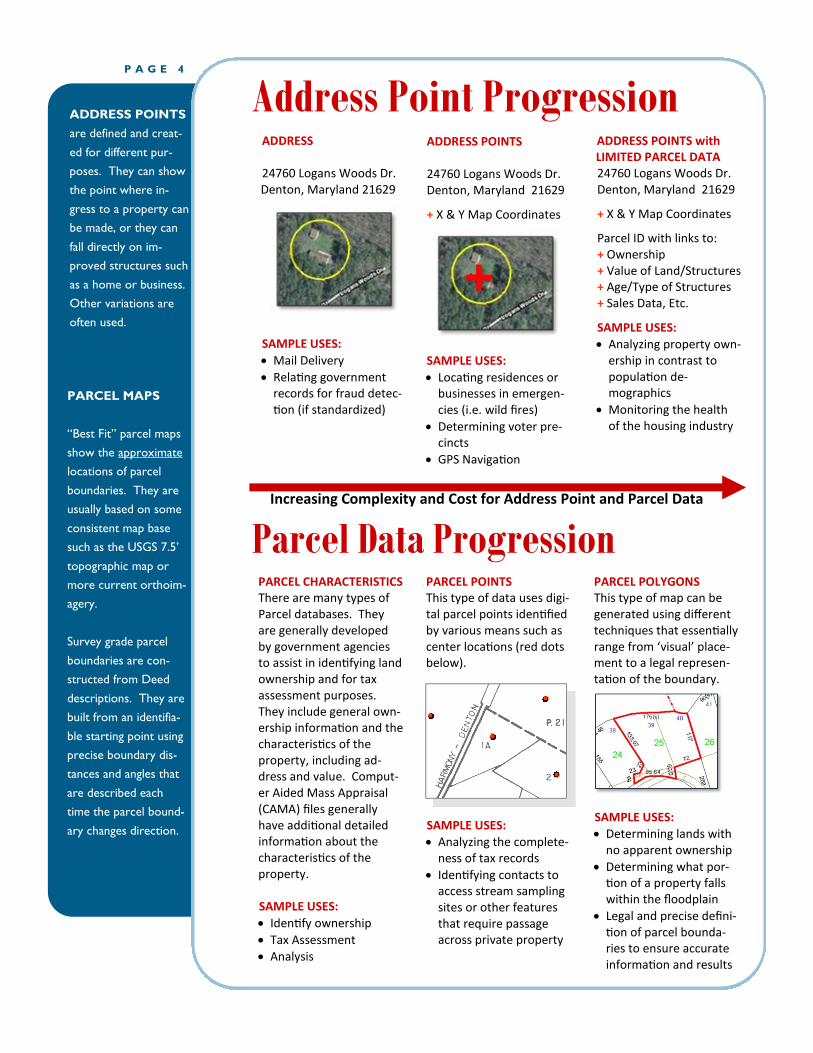
PARCEL MAPS
“Best Fit” parcel maps
show the approximate
locations of parcel
boundaries. They are
usually based on some
consistent map base
such as the USGS 7.5’
topographic map or
more current orthoim-
agery.
Survey grade parcel
boundaries are con-
structed from Deed
descriptions. They are
built from an identifia-
ble starting point using
precise boundary dis-
tances and angles that
are described each
time the parcel bound-
ary changes direction.
Address Point Progression ADDRESS 24760 Logans Woods Dr. Denton, Maryland 21629
SAMPLE USES:
Mail Delivery
Relating government records for fraud detec-tion (if standardized)
ADDRESS POINTS 24760 Logans Woods Dr. Denton, Maryland 21629
+ X & Y Map Coordinates
SAMPLE USES:
Locating residences or businesses in emergen-cies (i.e. wild fires)
Determining voter pre-cincts
GPS Navigation
ADDRESS POINTS with LIMITED PARCEL DATA 24760 Logans Woods Dr. Denton, Maryland 21629
+ X & Y Map Coordinates
Parcel ID with links to: + Ownership + Value of Land/Structures + Age/Type of Structures + Sales Data, Etc.
SAMPLE USES:
Analyzing property own-ership in contrast to population de-mographics
Monitoring the health of the housing industry
PARCEL POINTS This type of data uses digi-tal parcel points identified by various means such as center locations (red dots below).
SAMPLE USES:
Analyzing the complete-ness of tax records
Identifying contacts to access stream sampling sites or other features that require passage across private property
PARCEL POLYGONS This type of map can be generated using different techniques that essentially range from ‘visual’ place-ment to a legal represen-tation of the boundary.
SAMPLE USES:
Determining lands with no apparent ownership
Determining what por-tion of a property falls within the floodplain
Legal and precise defini-tion of parcel bounda-ries to ensure accurate information and results
PARCEL CHARACTERISTICS There are many types of Parcel databases. They are generally developed by government agencies to assist in identifying land ownership and for tax assessment purposes. They include general own-ership information and the characteristics of the property, including ad-dress and value. Comput-er Aided Mass Appraisal (CAMA) files generally have additional detailed information about the characteristics of the property. SAMPLE USES:
Identify ownership
Tax Assessment
Analysis
Increasing Complexity and Cost for Address Point and Parcel Data
ADDRESS POINTS
are defined and creat-
ed for different pur-
poses. They can show
the point where in-
gress to a property can
be made, or they can
fall directly on im-
proved structures such
as a home or business.
Other variations are
often used.
Parcel Data Progression

Why Should We Do Anything?
P A G E 5 A N S G I C I S S U E S B R I E F
The Danish Government has de-termined the direct economic benefit of building and sharing their national address data is $18 million annually with 70% of that going to the private sector. Giv-en the size ratios of the two countries, this would equate to over $1 billion annually for the U.S. economy. If this isn’t enough incentive, consider the following.
The Government Accountability Office (GAO) has been directed by Congress to identify federal programs, agencies, offices and initiatives, either within depart-ments or government-wide,
which have duplicative goals or activities. In their first annual report (GAO-11-318SP, March 2011), they have identified many duplicative programs and provid-ed supporting information about their wasteful practices. Nothing in this report relates to the pro-duction or maintenance of geo-spatial data which can be among the most costly of all data types.
In the 112th Congress, Repre-sentative Brady (TX) introduced HR 235 which calls for the Feder-al Office of Management and Budget (OMB) to provide addi-tional oversight and help Con-gress identify duplicative and
a good substitute for address point data.
Both parcels and addresses are important data resources, but each is a poor substitute for the other. Parcels are needed for applications where details of land owner-ship and extent are important. The key question for potential parcel data usage should be, “Are depictions of land own-ership boundaries necessary?" If the answer is 'yes,' parcels are needed. If 'no,’ and loca-tions are referenced to struc-tures or addresses, then ad-dress points are likely to be the less costly option, in addi-tion to being simpler to build, maintain and utilize.
Many data integration pro-jects exist where addresses in tabular (non-geographic) form are the greatest common fac-
tor between disjointed data resources. In some cases, both parcels and addresses are required. For example, during a flood event, no one will provide their parcel ID number as a rescue location. An address or location description based on streets will most likely be used to find the person in dis-tress. However, for flood in-surance payments and other analyses of flooding impacts, a parcel dataset will be the best reference layer, because it can show the specific level of im-pacts for each property.
Due to the complexities and cost of developing digital par-cel maps, joining parcel data attributes such as acreage and assessed value to address point files can be a valuable interim product.
Parcels are units of land with well-defined boundaries and are most often used in con-junction with analyses related to land ownership. Addresses are conceptual locations that are paired with a commonly used reference name.
Addresses may refer to sever-al locations within the same general area (entrance, struc-ture, lot, campus, etc.), and there are valid cases for rep-resenting addresses as a single point, collection of points, or a polygon. Parcels often have many attributes and the rela-tionship between site ad-dresses and parcels can be ‘many to many.’ A single ad-dress may refer to a collection of parcels and a single parcel may have many addresses that fall within its bounds. For this reason, parcel data is not
Using Address Points and Parcel Maps
By not coordinating
the development of a
national address point
file, the United States
is losing $1 billion
annually in economic
benefits and wasting
over $1 billion through
duplication of effort.
wasteful programs through lan-guage contained in Section 11.
OMB Circular A-16 already identi-fies Federal agencies that should be the stewards of select geospa-tial data types. Unfortunately, many agencies ignore their man-date to become the custodian, which results in other agencies duplicating effort to serve their own purposes.
The existing duplication of effort at all levels of government to create address point files easily exceeds $1 billion and most of the data is not publicly accessi-ble.

If a national address point file can be publicly sharea-ble, the U.S. Census Bu-reau should become the data steward for this file and adhere to the new Supplemental Guidance in OMB Circular A-16.
If existing privacy con-straints cannot be ad-dressed, another Federal agency without such con-straints should become the custodian of address points and all other agen-cies should obtain their information from this un-restricted source.
States must coordinate the development of address point files working with local governments.
In anticipation of the 2020 decennial Census, and to support the American Community Survey, the U.S. Census Bureau should
A framework allowing Federal, state and local government agencies to partner on produc-tion of Address Points must be encouraged/mandated and funded. Opportunities should also exist for the private sector to participate. The following steps will promote this partner-ship:
Congress should instruct Federal agencies to jointly develop a common ad-dress point file in coopera-tion with state and local governments and ensure that this file will be public-ly available to promote economic growth and gov-ernment efficiency.
Congress should look at
the multiple efforts of fed-eral agencies to maintain nation-wide address data and move to eliminate duplication.
contract with willing States to coordinate state and local government address data activity and to pro-vide pass-through funding to maintain local address point files. These data should be developed local-ly with local and state agencies acting as data integrators.
A national business plan for address points must be created and adopted by all Federal, state and local agencies, including a suita-ble data standard, data model, exchange standard and funding model.
The National States Geographic Information
Council (NSGIC) is a nonpartisan 501 (c) 6
organization committed to efficient and effec-
tive government through the prudent adoption
of geospatial technologies. Established in 1991,
NSGIC voting members include senior state
geographic information officers, coordinators,
managers and statewide GIS Councils.
NSGIC’s mission is to promote statewide geo-
spatial coordination activities in all states and
be an effective advocate for states in national
geospatial policy initiatives, thereby enabling
the National Spatial Data Infrastructure
Phone: 443-640-1075
Fax: 443-640-1031
E-mail: [email protected]
Web: http://www.nsgic.org
2105 Laurel Bush Road
Suite 200
Bel Air, Maryland 21015
National States Geographic
Information Council (NSGIC)
Steps that Need to be Taken
May 14, 2013

Appendix 3. Basis for Regional Commission-DCA role to provide operational framework services for GIO
Georgia Data Base and Network- OCGA 50-8-7(b)(1) states that
“The department shall coordinate and participate in compiling, and other state agencies and local governments shall participate in compiling, a Georgia data base and network to serve as a comprehensive source of information available, in an accessible form, to local governments and state agencies. The Georgia data base and network shall collect, analyze, and disseminate information with respect to local governments, regional commissions, and state agencies. The Georgia data base and network shall include information obtained or available from other governments and information developed by the department. To maintain the Georgia data base and network, the department shall make, and shall coordinate with other state agencies and local governments in making, comprehensive studies, investigations, and surveys of the physical, social, economic, governmental, demographic, and other conditions of the state and of local governments and of such other aspects of the state as may be necessary to serve the purposes of the department. The department shall make available the Georgia data base and network, or provide access to the Georgia data base and network, to other state agencies, local governments, members of the General Assembly, and residents of the state;”
OCGA 36-70-4(a) states that,
“Each municipality and county shall automatically be a member of the regional commission for the region which includes such municipality or county, as the case may be.”
OCGA 36-70-4(c) states that,
“Each municipality and county shall participate in compiling a Georgia data base and network, coordinated by the department, to serve as a comprehensive source of information available, in an accessible form, to local governments and state agencies.” (State of Georgia, 2014)
GTA‐GIO Task Force Report

Appendix 4. Basis for Regional Commission-GTA role to provide operational framework services for GIO
In the Georgia Technology Authority’s enabling legislation, OCGA 50-25-1(b)(13) states that:
"Technology enterprise management" means methods for managing technology resources for all agencies, considering the priorities of state planners, with an emphasis on making communications and sharing of data among agencies feasible and ensuring opportunities of greater access to state services by the public.
Similarly, OCGA 50-25-1(c) states that:
“The purpose of the authority shall be to provide for technology enterprise management and technology portfolio management...”
Further, OCGA 50-25-1(c) states more specifically that the purpose of the authority is to provide for:
(1) The public interest in providing ready access to public state information for individuals, businesses, and other entities;
(2) The public interest in providing ready access to state information for other governmental entities, so as to enhance the ability of such other governmental entities to carry out their public purposes;
(3) Fair and adequate compensation to the state for costs incurred in generating, maintaining, and providing access to state information;
(4) Cost savings to the state through efficiency in the provision of public information; and
(5) Such other factors as are in the public interest of the state and will promote the public health and welfare. (State of Georgia, 2014)
GTA‐GIO Task Force Report

Appendix 5. Basis for Regional Commission-OPB role to provide operational framework services for GIO
The Governor’s Office of Planning and Budget’s enabling legislation, OCGA 45-12-173, states that: Office to promote state development; duties of Governor; employment of personnel; furnishing of advice and assistance by other state officials (a) The Office of Planning and Budget shall perform the function of promoting the orderly growth and development of the state through the proper planning and programming of the affairs of state government. The Governor shall be ex officio director of state planning. (b) The Governor, through the Office of Planning and Budget, shall make available such planning and programming service, technical assistance, information, and advice as specified in this Code section and Code Sections 45-12-174 through 45-12-176 to departments, agencies, and institutions of state government, to the General Assembly, and to local and joint units of government and other public bodies as may be appropriate to achieve the purposes of this Code section and Code Sections 45-12-174 through 45-12-176. (c) The Governor, through the Office of Planning and Budget, shall encourage comprehensive and coordinated planning and programming of the affairs of the state government. He may inquire into the methods of planning and program development in the conduct of the affairs of state government; he may prescribe for adequate systems of records for planning and programming purposes; and he may prescribe the institution and uses of standards for effective planning and programming. (d) The Governor shall prepare and submit to the General Assembly a development program for the consideration and review of the General Assembly. A program budget report shall satisfy this requirement. The development program shall be submitted within five days after the organization of the General Assembly for review with the budget document. (e) The director of the Office of Planning and Budget is authorized and directed to employ fully qualified professional, technical, and clerical personnel as required to carry out the duties prescribed in this Code section and Code Sections 45-12-174 through 45-12-176. (f) The Attorney General, the state auditor, and such other state officials as shall be called upon shall render such advice and assistance and furnish such information to the Office of Planning and Budget as may be requested and needed.
GTA‐GIO Task Force Report

Appendix 6. Georgia Code Commercializing Local GIS
O.C.G.A. 50-29-2
50-29-2. Authority of public agencies that maintain geographic information systems to contract for the provision of services; fees; contract provisions (a) Notwithstanding the provisions of Article 4 of Chapter 18 of Title 50, a county or municipality of the State of Georgia, a regional commission, or a local authority created by local or general law that has created or maintains a geographic information system in electronic form may contract to distribute, sell, provide access to, or otherwise market records or information maintained in such system and may license or establish fees for providing such records or information or providing access to such system. (b) Any fees or license fees established pursuant to subsection (a) of this Code section shall be based upon the recovery of the actual development cost of creating or providing the geographic information system and upon the recovery of a reasonable portion of the costs associated with building and maintaining the geographic information system. The fees may include cost to the county, municipality, regional commission, or local authority of time, equipment, and personnel in the creation, purchase, development, production, or update of the geographic information system. (c) Any contract authorized by subsection (a) of this Code section shall include provisions that: (1) Protect the security and integrity of the system; (2) Limit the liability of the county, municipality, regional commission, or local authority for providing the services and products; (3) Restrict the duplication and resale of the services and products provided; and (4) Ensure that the public is fairly and reasonably compensated for the records or information or access provided. (d) A county, municipality, a regional commission, or local authority may contract with a private person or corporation to provide the geographic information system records or information or access to the system to members of the public as authorized by this Code section.
GTA‐GIO Task Force Report

References Carswell, William J. The 3D Elevation Program- Summary for Georgia. Draft of a program flyer in preparation by USGS. February 26, 2014. Carter, Buddy. Senate Bill 361- Georgia Geospatial Advisory Council. http://www.legis.ga.gov/legislation/en-US/Display/20132014/SB/361 Cimons, Marlene. Geospatial Technology as a Core Tool. in US News & World Report. May 11, 2001. http://www.usnews.com/science/articles/2011/05/11/geospatial-technology-as-a-core-tool DCA. Community Analysis along the April 27-28, 2011 Tornado Tracks in Georgia. 2011. http://www.georgiaplanning.com/TornadoApril2011.htm DCA and Polis. Hazard Risk Analyses Supplement to the Richmond County Joint Hazard Mitigation Plan. 2013. http://www.georgiaplanning.com/DREF/documents/Richmondpilot.zip Deal, Nathan. Governor’s Strategic Goals for Georgia. 2013 http://opb.georgia.gov/sites/opb.georgia.gov/files/related_files/site_page/State%20Goals%20April%202013%20FINAL.pdf FEMA. Disaster Mitigation Act of 2000. 2000. http://www.fema.gov/media-library/assets/documents/4596 FEMA. HAZUS-MH. 2013a. http://www.fema.gov/hazus FEMA. FEMA’s Coastal Risk MAP Study for Georgia. 2013 http://www.gafloods.org/pdf/2013/Coastal_Update.pdf FEMA. Risk MAP program. 2013b. http://www.fema.gov/risk-mapping-assessment-planning GGAC. Georgia Geospatial Advisory Council. 2010 Georgia Geospatial Audit: Status Report and Recommendations. 2010. https://www.georgiaspatial.org/ggac GTA. Agency IT Dependent Goals. Prepatory Reading for Georgia 2010 Strategy with Technology Summit. November 4, 2013. http://gta.georgia.gov/egap/georgia-2020-strategy-technology-summit Horton, Jack. Basic Spatial Data Modeling and Analysis Techniques for the Appraiser and GIS Analyst. In Integrating GIS & CAMA, Selected Papers for Professional in Assessment, Appraisal, Land Records, and Information Technology. Urban and Regional Information Systems Association and the international Association of Assessing Officers. URISA- Park Ridge, IL. 1999. Jackson, Terry and Kevin Mickey. Georgia HAZUS Project- A Model for Success Through Collaboration. Presented at the 6th Annual HAZUS-MH Conference, August 19, 2013, in Indianapolis Indiana. 2013. https://app.box.com/s/czrbhbxn3g6b14s9usdk#/s/czrbhbxn3g6b14s9usdk/1/1091307000/9850989594/1?&_suid=1387170067557021171910142216366 Jackson, Terry and Robert W. Woodruff. Georgia in Statewide Leadership and Coordination of Geographic Information and Related Technology in the 50 States by Lisa Warnecke with Drew Decker, Leslie Pelch, Stuart Davis and Judy Gilligan. NSGIC. 2002. Archive copy at http://www.georgiaplanning.com/documents/NGIC/StateSummaries2001.pdf McMahon, Sharon. Smart Government. Bureaucracy with a Business Brain, Commission for a New Georgia. Mercer University Press. Macon, GA. 2010 NSGIC. National State Geographic Information Council. FGDC Future Directions- Fifty State Initiative. February 2009a
GTA‐GIO Task Force Report

GTA‐GIO Task Force Report
NSGIC. National State Geographic Information Council. Measuring Progress of the Fifty States Initiative Report. September 2009b. http://www.fgdc.gov/policyandplanning/measureprogress Smith, Ernie. Minutes GISCC-Elevation Technical Working Group Meeting. Middle Georgia Regional Commission. July 27, 2011. State of Georgia. Official Code of Georgia Annotated (O.C.G.A.). http://www.lexisnexis.com/hottopics/gaCode/ .2014 USGS. National Enhanced Elevation Assessment. 2011a. http://nationalmap.gov/3DEP/neea.html USGS. Publicly Available Enhanced Elevation Data. 2011b. Map at http://nationalmap.gov/3DEP/documents/enhanced_elevation_data.pdf Snyder, Gregory L. The 3D Elevation Program- Summary of Program Direction. USGS flyer. USGS. September 13, 2012. Warnecke, Lisa, with John M. Johnson, Karen Marshall, and R. Steven Brown. Georgia in State Geographic Activities Compendium. Council of State Governments. 1992 Archive copy at http://www.georgiaplanning.com/documents/NGIC/GeorgiaSummary1992.pdf