A case study on Philippine Cities’ Initiatives
98
| Sustainable Urban Mobility —Philippine Cities’ Initiatives A Case Study of Philippine Cities’ Initiatives | June – December 2017 © IBellen / WWF-Philippines
Transcript of A case study on Philippine Cities’ Initiatives

| S u s t a i n a b l e U r b a n M o b i l i t y — P h i l i p p i n e C i t i e s ’ I n i t i a t i v e s
A Case Study of Philippine Cities’ Initiatives | June – December 2017
© KCDDYangot /WWF-Philippines
© IBellen / WWF-Philippines

i | S u s t a i n a b l e U r b a n M o b i l i t y — P h i l i p p i n e C i t i e s ’ I n i t i a t i v e s
ACKNOWLEDGMENT
WWF is one of the world’s largest and most experienced independent conservation organizations, with over 5 million supporters and a global network active in more than 100 countries. WWF-Philippines has been working as a national organization of the WWF network since 1997. As the 26th national organization in the network, WWF-Philippines has successfully been implementing various conservation projects to help protect some of the most biologically-significant ecosystems in Asia. Our mission is to stop, and eventually reverse the accelerating degradation of the planet’s natural environment and to build a future in which humans live in harmony with nature. The Sustainable Urban Mobility: A Case Study of Philippine Cities’ Initiatives is undertaken as part of the One Planet City Challenge (OPCC) 2017-2018 project. Project Manager: Imee S. Bellen Researcher: Karminn Cheryl Dinney Yangot WWF-Philippines acknowledges and appreciates the assistance extended to the case study by the numerous respondents and interviewees, particularly the following:
Baguio City
City Mayor Mauricio Domogan
City Environment and Parks Management Officer, Engineer Cordelia Lacsamana
City Tourism Officer, Jose Maria Rivera
Department of Tourism, Cordillera Administrative Region (CAR) Regional Director Marie Venus Tan
Federation of Jeepney Operators and Drivers Associations—Baguio-Benguet-La Union (FEJODABBLU) Regional
President Mr. Perfecto F. Itliong, Jr.
Cebu City
City Mayor Tomas Osmeña
City Administrator, Engr. Nigel Paul Villarete
City Environment and Natural Resources Officer, Ma. Nida Cabrera
Cebu City BRT Project Manager, Atty. Rafael Yap
Association of Barangay Captains (ABC) President, Philip Zafra
Mr. Valeriano Avila, Business Owner, Former Traffic Czar and Publicist
Vigan City
City Tourism Officer, Edgar dela Cruz
Pasig City
City Environment and Natural Resources Office Head, Racquel Naciongayo
Muntinlupa City
Lingkod Muntinlupa Foundation (LFM) Program Director, Miss Grace Salvador
Mandaluyong City
Tricycle Regulation Officer, Mr. Cielo Martinez
Marikina City
Marikina Bikeways Program Officer, Engineer Rommel Felipe
Cover Photo: Imee S. Bellen Additional Edits: Atty. Angela Consuelo S. Ibay

ii | S u s t a i n a b l e U r b a n M o b i l i t y — P h i l i p p i n e C i t i e s ’ I n i t i a t i v e s
EXECUTIVE SUMMARY
This urban mobility case study is an amalgamation of the ingenuity of several Philippine cities to achieve
sustainability through governance. It is likewise an effort of WWF-Philippines to promote a climate resilient
future where carbon emissions are kept at low bay and the quality of life is improved by means of management
of cities.
Chapter 1 discusses transportation and mobility as ladders to achieving the sustainable development
goals. There are no standalone Sustainable Development Goals (SDGs) that focus on transportation and
mobility, but targets related to them are embedded in the entire document. For this case study, SDG 11 on
making sustainable cities and communities is the context within which “mobility” is used and discussed. The
role of cities is also tackled. Being agents of development, cities have very crucial roles in facilitating and
regulating mobility.
Chapter 2 dwells on WWF’s One Planet City Challenge. This case study is an outgrowth of the Challenge.
Since the thematic focus this year is sustainable mobility, homegrown initiatives of Philippine cities in line with
the former are highlighted and analyzed.
Chapter 3 is an overview of the current situation of the transport sector in the country. It elucidates
various national policies that have an impact on local governance. Among these is the National Environmentally
Sustainable Transport, which was crafted as a framework policy of the State to fulfill its commitment to the
Bangkok Declaration Sustainable Transport Goals for 2010-2020. This chapter also provides the foundation for
managing mobility locally to target the national problems on sustainability.
Chapter 4 shows the criteria for which Philippine cities were selected for visitation. It also includes a
discussion on data gathering framework and methodology used in this case study. Desk research, personal
interviews, and participant-observation were employed to gather data. Personalities from both the government
and private sector (residents, drivers, businesspeople included) were approached to shed light on matters
related to the study.
Chapter 5 contains the bulk of the study, with the detailed illustration of diverse homegrown initiatives.
The initiatives were classified into four major categories: pedestrianization and walkability, mass transport,
alternative modes of transport, and institutional policies. The first initiative includes carless days,
pedestrianization, and green spaces. The second one focuses on the Bus Rapid Transit. The third initiative
involves electric vehicles such as e-jeepneys and e-trikes, as well as bike programs. The fourth category
concentrates on institutional policies that have impacts on mobility such as public utility jeepney/public utility
vehicle (PUJ/PUV) bans.
Chapter 6 summarizes and concludes this paper. It correspondingly enumerates ways forward that cities
can adopt to ease the congestion situation in their respective localities. Both short- and long-term solutions are
discoursed on in this chapter, the long-term being the sustainable urban mobility plan.
Notwithstanding the fact that the study is not conclusive of all cities in the country, it still gives a good
window into the state of affairs in the grassroots. As such, it is the hope of WWF Philippines to provide a
sustainable mobility catalogue for cities in the national and international scene.

iii | S u s t a i n a b l e U r b a n M o b i l i t y — P h i l i p p i n e C i t i e s ’ I n i t i a t i v e s
TABLE OF CONTENTS
1.1 Sustainable Transportation and Development ................................................................................. 2
1.2 Sustainable Mobility and Development ............................................................................................ 4
1.3 The Role of Cities ............................................................................................................................... 5
2.1 One Planet City Challenge: What is it? .............................................................................................. 7
2.2 Thematic Focus on Sustainable Mobility ........................................................................................... 8
3.1 Brief Overview ................................................................................................................................... 9
3.2 Challenges and Developments in the Urban Landscape ................................................................. 10
3.2.1 State of Philippine Traffic ........................................................................................................ 13
3.2.2 Philippine Modes of Transport ................................................................................................ 16
3.3 Formulation of a National Environmentally Sustainable Transport Strategy ................................. 19
4.1 Selecting Cities ................................................................................................................................. 22
4.2 Data Gathering Framework ............................................................................................................. 23
4.3 Case Methodology ........................................................................................................................... 25
5.1 Categories of City Initiatives ............................................................................................................ 30
5.2 Pedestrianization, Walkability & Green Spacing ............................................................................. 32
5.2.1 VIGAN CITY—Calle Crisologo Pedestrianization ..................................................................... 32
5.2.2 PASIG CITY—Carless Sundays and Walkability ....................................................................... 37
5.2.3 MAKATI CITY—Pedestrianization ............................................................................................ 41
5.2.4 ILOILO CITY—Green Spaces ..................................................................................................... 43
5.2.5 SAN FERNANDO CITY, La Union—Walk Clean, Breathe Clean Initiative................................. 44
5.3 MASS TRANSPORTATION ................................................................................................................. 46

iv | S u s t a i n a b l e U r b a n M o b i l i t y — P h i l i p p i n e C i t i e s ’ I n i t i a t i v e s
5.3.1 CEBU CITY—Bus Rapid Transit (BRT)........................................................................................ 46
5.3.2 GENERAL SANTOS CITY—Hybrid Electric Road Train (HERT) .................................................. 56
5.3.3 MUNTINLUPA CITY—Electronic Jeepney Ride for Free (e-JRF) Program ................................ 58
5.3.4 MAKATI CITY—E-Jeepney Project ........................................................................................... 60
5.3.5 MANDALUYONG CITY—E-Trike Pilot Project .......................................................................... 62
5.3.6 BACOOR CITY, CAVITE — Green Franchise and E-Trike Fleet Service ..................................... 64
5.3.6 NAGA CITY, Bicol--City Electric Transportation ....................................................................... 65
5.3.7 PUERTO PRINCESA CITY—E-trike Pilot Project ........................................................................ 66
5.3.8 MANILA CITY—E-Trike Project ................................................................................................ 66
5.4 NON-MOTORIZED TRANSPORT ........................................................................................................ 67
5.4.1 MARIKINA City—Bikeways Program ........................................................................................ 67
5.4.2 PASIG CITY—Bike Programs .................................................................................................... 71
5.4.3 NAGA CITY—Bike Festival ....................................................................................................... 71
5.4.4 CEBU CITY—Bike Lanes ............................................................................................................ 72
5.5 INSTITUTIONAL POLICIES ................................................................................................................. 74
5.5.1 BAGUIO CITY ............................................................................................................................ 74
6.1 SUMMARY ........................................................................................................................................ 85
6.2 ISSUES AND CHALLENGES ................................................................................................................ 86
6.3 RECOMMENDATIONS ...................................................................................................................... 90
6.4 CONCLUSION .................................................................................................................................... 92

v | S u s t a i n a b l e U r b a n M o b i l i t y — P h i l i p p i n e C i t i e s ’ I n i t i a t i v e s
ACRONYMS
ADB Asian Development Bank
AMT Alternative Modes of Transport
BRT Bus Rapid Transit
CAR Cordillera Autonomous Region
DOT Department of Tourism
DOTC Department of Transportation and Communications
DOTr Department of Transportation
GHG Greenhouse Gas
JICA Japan International Cooperation Agency
LRT Light Rail Transit
MDG Millennium Development Goals
MRT Metro Rail Transit
NCR National Capital Region
NEDA National Economic Development Authority
NEST National Environmentally Sustainable Transport
NMT Non-Motorized Transport
PDP Philippine Development Plan
PSA Philippine Statistics Authority
PPP Public-Private Partnership
OPCC One Planet City Challenge
SDG Sustainable Development Goals
UN United Nations
WB World Bank
WBCSD World Business Council for Sustainable Development
WWF World Wide Fund for Nature

1 | S u s t a i n a b l e U r b a n M o b i l i t y — P h i l i p p i n e C i t i e s ’ I n i t i a t i v e s
INTRODUCTION
Sustainable mobility means many things when it comes to policy debate. There is a shifting emphasis:
sustainable transportation, sustainable freight transport, walkability, non-motorized transport (NMT), and
connectivity, among others. There so many “sustainable”+ (qualifiers), but what does sustainable urban
mobility really mean?
Sustainable mobility is the ability to meet the needs of society to move freely, gain access,
communicate, trade, and establish relationships without sacrificing other essential human or ecological values
today or in the future1. Why is this an imperative issue for cities?
Cities are home to half of the human population, numbering around 3.5 billion people2. History
teaches us that where people populate, progress thrives—culturally, economically, and socially. It is a proper
report that while urbanization “has the potential to usher in a new era of well-being, resource efficiency and
economic growth3,” it is also a source of poverty and inequality.
Why do we manage mobility? Why do we want to make it sustainable? Is it because of transportation
demand? Human demand? Will it improve the quality of life? Will it decongest urban centers? Or lessen
vehicular traffic? Mitigate environmental pollution?
Mobility management is one key to equalize the imbalance. By advocating for sustainable mobility
amongst cities, the quality of life therein can be further improved. The transport sector is one facilitator of
movement and development that is seen as an essential tool for mobility management. Concerted efforts of
local government units and other concerned sectors are also essential elements in the evaluation of
sustainability.
This case study is an attempt to do that. It is an initial catalogue of homegrown sustainable mobility
initiatives being done by Philippine cities as solutions to the problem on climate change. An offshoot of World
Wide Fund for Nature (WWF) - Philippines’ One Planet City Challenge, this study includes not only a list of
programs and projects, but also a brief backgrounder on the transportation situation in the country as well as
related national policies that focus on mobility. Similar to a policy paper, it likewise has a set of policy
recommendations that local government units may adopt to further alleviate the congestion problem in their
respective jurisdictions.
1 World Business Council for Sustainable Development in p.8, Singh, Seema. (2014). Policies for Sustainable Mobility. The Energy and Resources Institute TERI-NFA Working Paper No. (13). 2 SDG 11 Facts and Figures: http://www.un.org/sustainabledevelopment/cities/ 3 UNFPA: http://www.unfpa.org/urbanization

2 | S u s t a i n a b l e U r b a n M o b i l i t y — P h i l i p p i n e C i t i e s ’ I n i t i a t i v e s
Transportation and Mobility:
Ladders to Achieving Sustainable
Development
lso known as the post-2015 development agenda,
the Sustainable Development Goals (SDG) are a set
of goals authored by world leaders to serve as a
guide for nations to achieve sustainable development. There has
been a substantial shift from economism, to human development (as
hallowed in the Millennium Development Goals or MDGs), and now,
to the SDG.
One of the SDGs focuses particularly on sustainable cities
and communities. It is the same goal that explicates mobility as used in
this study. It is consequently but proper to discuss two interweaving
concepts to lie out the foundations of the ensuing chapters.
1.1 Sustainable Transportation and Development
he question is simple. What is the role of the transport sector in achieving the SDG?
One quarter of the energy-related greenhouse gas (GHG) emissions in the world are
attributable to the transport sector4. As a main consumer of fossil fuel energy and “emitter” of GHG,
managing the sector can help in achieving the SDG on energy5.
In the 2030 Agenda, the United Nations stated that:
[…] ‘sustainable transport systems, along with universal access to affordable, reliable, sustainable and
modern energy services, quality and resilient infrastructure, and other policies that increase productive
capacities, would build strong economic foundations for all countries’ (para 27).6
There is no particular standalone SDG dedicated to transportation. However, it is indirectly embedded
in many other Goals. This means that the transport sector is cardinal to the accomplishment of the objectives
and the achievement of the goals7. It has a title role in sustainable development. This is discussed in the
Agenda 218 as one among the many issues of development9.
4 SDKP. (n.d.). Sustainable Development Knowledge Platform. Available at https://sustainabledevelopment.un.org/topics/sustainabletransport 5 Mohieldin, Mahmoud and Nancy Vandycke. (2017). ‘Sustainable Mobility in the 21st Century.’ In The World Bank. Accessed at http://www.worldbank.org/en/news/feature/2017/07/10/sustainable-mobility-for-the-21st-century. 6 SLoCaT (2017) Accessible at: http://www.slocat.net/sdgs-transport 7 Id note 2. 8The Agenda 21 is the outcome of the 1992 United Nation’s Earth Summit. 9 Id note 1.
A
T
Globally, the number of
vehicles on the road is
expected to double by 2050.
Mohieldin and Vandycke, 2017
3 | S u s t a i n a b l e U r b a n M o b i l i t y — P h i l i p p i n e C i t i e s ’ I n i t i a t i v e s
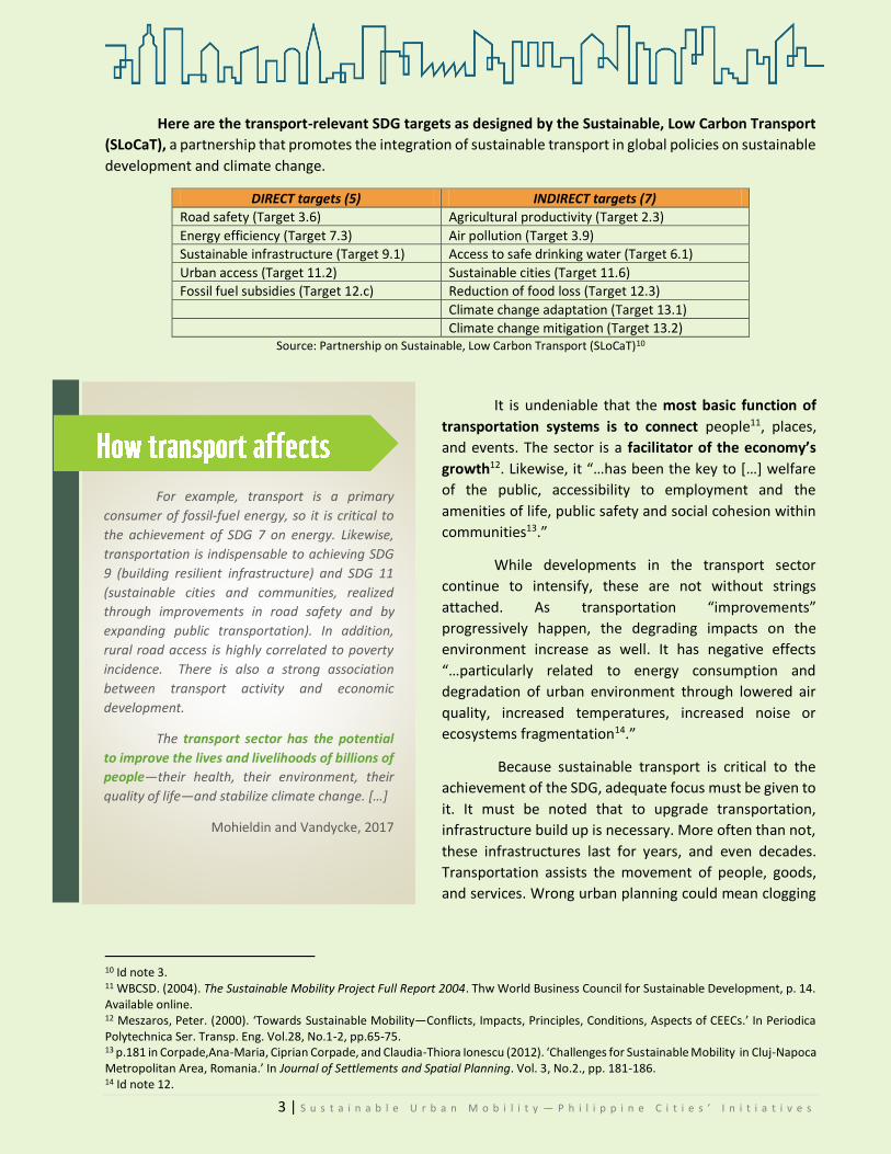
Here are the transport-relevant SDG targets as designed by the Sustainable, Low Carbon Transport
(SLoCaT), a partnership that promotes the integration of sustainable transport in global policies on sustainable
development and climate change.
DIRECT targets (5) INDIRECT targets (7)
Road safety (Target 3.6) Agricultural productivity (Target 2.3)
Energy efficiency (Target 7.3) Air pollution (Target 3.9)
Sustainable infrastructure (Target 9.1) Access to safe drinking water (Target 6.1)
Urban access (Target 11.2) Sustainable cities (Target 11.6)
Fossil fuel subsidies (Target 12.c) Reduction of food loss (Target 12.3)
Climate change adaptation (Target 13.1)
Climate change mitigation (Target 13.2) Source: Partnership on Sustainable, Low Carbon Transport (SLoCaT)10
It is undeniable that the most basic function of
transportation systems is to connect people11, places,
and events. The sector is a facilitator of the economy’s
growth12. Likewise, it “…has been the key to […] welfare
of the public, accessibility to employment and the
amenities of life, public safety and social cohesion within
communities13.”
While developments in the transport sector
continue to intensify, these are not without strings
attached. As transportation “improvements”
progressively happen, the degrading impacts on the
environment increase as well. It has negative effects
“…particularly related to energy consumption and
degradation of urban environment through lowered air
quality, increased temperatures, increased noise or
ecosystems fragmentation14.”
Because sustainable transport is critical to the
achievement of the SDG, adequate focus must be given to
it. It must be noted that to upgrade transportation,
infrastructure build up is necessary. More often than not,
these infrastructures last for years, and even decades.
Transportation assists the movement of people, goods,
and services. Wrong urban planning could mean clogging
10 Id note 3. 11 WBCSD. (2004). The Sustainable Mobility Project Full Report 2004. Thw World Business Council for Sustainable Development, p. 14. Available online. 12 Meszaros, Peter. (2000). ‘Towards Sustainable Mobility—Conflicts, Impacts, Principles, Conditions, Aspects of CEECs.’ In Periodica Polytechnica Ser. Transp. Eng. Vol.28, No.1-2, pp.65-75. 13 p.181 in Corpade,Ana-Maria, Ciprian Corpade, and Claudia-Thiora Ionescu (2012). ‘Challenges for Sustainable Mobility in Cluj-Napoca Metropolitan Area, Romania.’ In Journal of Settlements and Spatial Planning. Vol. 3, No.2., pp. 181-186. 14 Id note 12.
For example, transport is a primary
consumer of fossil-fuel energy, so it is critical to
the achievement of SDG 7 on energy. Likewise,
transportation is indispensable to achieving SDG
9 (building resilient infrastructure) and SDG 11
(sustainable cities and communities, realized
through improvements in road safety and by
expanding public transportation). In addition,
rural road access is highly correlated to poverty
incidence. There is also a strong association
between transport activity and economic
development.
The transport sector has the potential
to improve the lives and livelihoods of billions of
people—their health, their environment, their
quality of life—and stabilize climate change. […]
Mohieldin and Vandycke, 2017

4 | S u s t a i n a b l e U r b a n M o b i l i t y — P h i l i p p i n e C i t i e s ’ I n i t i a t i v e s
at important junctures in the city. Thus, planning is very important. The Cebu Bus Rapid Transit, as we will see
later on, is an illustrative case.
The growth of the transport sector is directly proportional to the growth of emissions of greenhouse
gas and fossil fuel consumption, environmental pollution, unless something is done. Even if these issues are
on a worldwide scale, it is the developing countries that bear the brunt of the burden.
1.2 Sustainable Mobility and Development
obility is mentioned only once in the agenda, under Goal 1015. Nonetheless, it is not a new
theme in the discourse on development. It has “…become one of the most crucial themes of
economic and social development of nations”16. Sustainable mobility “…means transport
systems and planning that are in line with concerns of sustainability; so its main goal is to
accommodate the right to mobility and the need to reduce the negative effects of
environmental pollution17.”
It is in line with Goal 11—Make cities and human settlements inclusive, safe, resilient and
sustainable—that mobility will be discussed, analyzed, and understood in this paper. There are many targets
under this goal, but particular focus is given on target 2:
By 2030, provide access to safe, affordable, accessible and sustainable transport systems for all, improving road
safety, notably by expanding public transport, with special attention to the needs of those in vulnerable
situations, women, children, persons with disabilities and older persons.
Diagram: The Challenges of Making Mobility Sustainable18
What do we need to ensure sustainable
mobility? We need sustainable modes of transport.
Aside from sustainable modes, new routes, as in
walking paths or the renovation of existing ones is
needed in the urban contexts19. The objective is to
make walking conducive and in that way encourage
car-free lifestyles, if not car-reduced ones. These
must all be integrated into a road network plan that
factors in both pedestrian and vehicular traffic.
In the 2012 The Future We Want20, world
leaders acknowledged the significance of
15 Transforming Our World: The 2030 Agenda for Sustainable Development https://www.un.org/pga/wp-content/uploads/sites/3/2015/08/120815_outcome-document-of-Summit-for-adoption-of-the-post-2015-development-agenda.pdf; mobility is mentioned once only in: Goal 10 (Reduce inequality within and among countries) under target 10.7 Facilitate orderly, safe, regular and responsible migration and mobility of people, including through the implementation of planned and well-managed migration policies. 16 p.164, Famoso, F. and IL Lanzafame (2013). ‘Urban mobility management: new challenges for a sustainable future.’ In Forum geografic. Studii și cercetări de geografie și protecția mediului. Vol. XII, Issue 2 (Dec.2013), pp. 164-170. 17 Ibid, p.165. 18 Id note 1, adapting the study of Molina and Molina (2002:14). 19 Id, note 16, p.155. 20 The Future We Want is the written product of the 2012 United Nations Conference on Sustainable Development (Rio +20).
M

5 | S u s t a i n a b l e U r b a n M o b i l i t y — P h i l i p p i n e C i t i e s ’ I n i t i a t i v e s
transportation and mobility to sustainable development, adding that cities have an equally vital role in
achieving them21.
22
Note that some cities are the size of nations in terms of population. Some nations such as Sweden and
Denmark are able to manage their population and resources. The same is not always true for other similarly-
sized cities such as Metro Manila.
1.3 The Role of Cities
ities are centers “…of employment, commerce, education, culture, social or political interaction23”.
Because of this, there are …significant demands for civil infrastructure needed to support social and
economic activities and a suitable quality of life24. All of these can be aggregated under the
phenomenon of urbanization.
How much area of the planet do cities occupy and how much of the planet’s resources do they use?
They occupy merely 2% of the world’s land but consume 75% of its resources25. With regard to waste, cities
generate a similar percentage.26
One scholar had to say:
This rapid development, with poor planning and decision-making has led to many serious urban
environmental problems. In the process, people from the countryside would migrate and settle in the
urban areas to work or to look for a better quality of life. This migration, on the one hand, has drastically
increased the population in the urban areas and contributed significantly to their economic activities.
On the other hand, large urban populations have caused serious urban related problems; one of which
is transport. In most developing Asian cities, road congestion is attributed to inadequate transport
21 Id note 1. 22 p. 5, ADB (2008). Managing Asian Cities: Sustainable and Inclusive Urban Solutions. Mandaluyong City, Philippines: Asian Development Bank. 23 Id note 13, p.181. 24 Ibid 25 ADB (2008:43), citing Girardet, Herbert. 1996. Giant footprints. Our Planet, 8(1):2123. 26 Ibid
C

6 | S u s t a i n a b l e U r b a n M o b i l i t y — P h i l i p p i n e C i t i e s ’ I n i t i a t i v e s
infrastructures, planning and management. The level of self-discipline on the part of the traveling public
could further aggravate this condition. This problem has in turn crucial economic and environmental
impacts on society as a whole.27.
Urban sustainability, therefore, requires rational mobility and sustainable transport that has a bearing
on the environment, the economy, and society.28 The swelling growth of urban centers makes cities an
indispensable agent in effecting change.
WWF recognizes that cities are the key to a climate-resilient and sustainable One Planet future. Our
goal is to find cities that are leading the way in sustainable urban development – and to reward those efforts.
And in doing so, help other cities.
Cities are hubs of connectivity, but how have they managed to mitigate the negative effects of
congestion? The initiatives underscored in the following sections will show the transformative solutions taken
by Philippine cities.
27 p.6, Murakami, A., et al (2003). ‘URBAN TRANSPORT AND LOCAL GOVERNANCE IN ASIAN DEVELOPING COUNTRIES – In Search of Transport Policies – (IATSS H493 Project Report).’ In IATSS RESEARCH. Vol.28 No.1, 2004, pp. 6-18. 28 7. p.87 Jimenes Herrero in Grieco, M. (2015). ‘Social sustainability and urban mobility: Shifting to a socially responsible pro-poor perspective’. Social Responsibility Journal, 11(1), 82-97. Retrieved from https://search.proquest.com/docview/1655718315?accountid=47253
CITIES MATTER. The role of cities in shaping the future of this planet grows stronger with each
passing day. More than half the world’s population now lives in cities. Imagine if these cities were
planned to enable everyone around the world to thrive and prosper while respecting the ecological
limits of our one and only planet. Well, these cities might not exist today, but WWF’s objective is to
support the creation and development of such places or what we call One Planet Cities. And
although urban lifestyles currently have a huge impact on the climate, local governments also have
great potential to reduce those impacts. A city’s choice of energy systems, transportation solutions,
and building standards affects huge numbers of people, and will ultimately determine our success
in the creation of a low-carbon, sustainable future.
WWF One Planet City Challenge 2017

7 | S u s t a i n a b l e U r b a n M o b i l i t y — P h i l i p p i n e C i t i e s ’ I n i t i a t i v e s
ONE PLANET CITIES
2.1 One Planet City Challenge: What is it?
he One Planet City Challenge (previously called Earth Hour
City Challenge29) was designed by WWF to mobilize action
and support from cities in the global transition toward a
climate resilient future run on 100 percent renewable
energy.
In a world where sustainable development and climate action are quickly becoming the top criteria for businesses and citizens alike, the Challenge is an opportunity for cities to showcase their livability and workability.
Local governments and municipalities in participating countries are invited to present holistic,
inspiring, and credible plans for combatting climate change and for dramatically increasing the use of sustainable, efficient and, renewable energy-based solutions in the next few decades. Photo: OPCC in Cities30
Entrants are also evaluated on their ability to realize other key benefits like increased resilience and enabling attractive, One Planet lifestyles. This 2017 special mention is given to cities that present impressive plans and actions for sustainable transport solutions. Local context, including resource availability, legal mandates, and basic needs of residents, is taken into consideration in order to create a level playing field for evaluation31.
2017 is the fifth anniversary of the biennial Challenge and the second year for the
Philippines to join. The criteria in evaluating said entrants are as follows32:
Level of ambition and ability to deliver on commitments and transformational change
Ability to integrate actions into coherent and overarching climate action plans
Determination to align with a transparent, science-based GHG emission reduction trajectory
Innovative approaches to addressing urban mobility
29 The EHCC Material (2016:6) notes, “[The Earth Hour Challenge is the] longest running comprehensive global sustainability contest for cities. It is unique in its combination of features: city participation through reporting emissions, plans and actions; professional consultation and feedback; and third party evaluation and selection by a high level independent international jury.” 30 http://wwf.panda.org/what_we_do/footprint/one_planet_cities/one_planet_city_challenge/ 31 Lifted in toto from the WWF One Planet City Challenge Spread, 2017. 32 Ibid
T

8 | S u s t a i n a b l e U r b a n M o b i l i t y — P h i l i p p i n e C i t i e s ’ I n i t i a t i v e s
WWF-Philippines propelled this case study as one of its OPCC deliverables. Simply put, this case study
is intended to be an initial catalogue of highlighted sustainable mobility initiatives done by cities in the
Philippines. It particularly muses on mobility initiatives that focus on walkability and pedestrianization, mass
transport, and other alternative modes of transport. Institutional policy initiatives such as banning of
motorized vehicles are also included along with related soft programs.
2.2 Thematic Focus on Sustainable Mobility
Two of the foremost issues faced by cities are
the management of the transport sector as well as of
mobility. It is prudent to say that sustainable
transportation can be classified under the umbrella term
of sustainable mobility.
Sustainable urban mobility requires a mind shift:
where transport in private cars and trucking give way to
different modes of public transport33. This includes ride-
sharing, cycling, non-motorized transport (electric and
hybrid vehicles), among others.
With the thematic focus on mobility of OPCC 2017-2018, this case study shows that there are
Philippine cities remarkably coming up with transformative solutions on mobility towards a sustainable one-
planet future.
33 From: http://wwf.panda.org/what_we_do/footprint/one_planet_cities/sustainable_mobility/
—transport and mobility solutions to
power the global transition to a low-
carbon, climate-resilient future—
ICLEI, from: http://www.iclei.org/details/article/wwfs-one-planet-city-challenge-will-recognize-cities-scaling-new-heights-on-climate-action.html

9 | S u s t a i n a b l e U r b a n M o b i l i t y — P h i l i p p i n e C i t i e s ’ I n i t i a t i v e s
Country Context: The Philippines
ho consumes the most energy in the country?
The transport sector. It consumes more energy than
any other sector, accounting for 36.5% of total
energy34. In addition, the sector accounts for more
than 70% of total energy demand for the petroleum
products consumption of the country35.
As emphasized in the National Environmentally Sustainable
Transport (NEST) Strategy, ‘most Filipinos take public transport with
an estimate of about 70% of the total person trips taking public
transport with as high as 80% in highly urbanized cities (HUCs)36.’
Further, at present,
there are ‘over 23,000 buses, 36,000 taxis and about
217,000 jeepneys providing public transport services
throughout the country37.’ The circumstances in Metro
Manila are more deplorable, where there are ‘more than
90,000 tricycles.38’ The transport sector, thus, is a sector
that merits discussion.
3.1 Brief Overview The Philippines is an archipelago composed of 7,107
islands, of which only about 3,144 are named. There are
three main islands: Luzon, Visayas, and Mindanao. These
groups of islands are further subdivided into regions, the
regions into provinces, and the provinces into cities and
municipalities. The cities and municipalities are further
subdivided into barangays39. The barangay is the basic
political unit.
The country is subdivided into 17 (seventeen)
regions, namely, Regions I-XIII, the National Capital Region
(NCR) or Metro Manila, Cordillera Administrative Region
(CAR), and the Autonomous Region in Muslim Mindanao
(ARMM). The (NCR) has 16 highly urbanized cities and one
34 As of 2008, from P. 7. NEST. (2011). Formulation of a National Environmentally Sustainable Transport Strategy for the Philippines, 2011. 35 Ibid 36 Ibid 37 Ibid 38 Ibid—based on independent surveys by local government units. In many places in the country, tricycles (paratransit mode) are the leading modes of transport for trips that cross cities, towns, or municipalities. 39 In toto, from p. 1. PSA. (2015). The Philippines in Figures. Philippine Statistics Authority. Available online.
W Population is rising and
planned transportation is key.
Source: PSA, https://psa.gov.ph/population-and-housing
10 | S u s t a i n a b l e U r b a n M o b i l i t y — P h i l i p p i n e C i t i e s ’ I n i t i a t i v e s
urban municipality. As of September 30, 2014, the country had 81 provinces, 144 cities, 1,490 municipalities,
and 42,029 barangays40.
According to the recent release of the Philippines Statistics Authority (PSA)41, the Philippine
population has exceeded 100 million. This is based on the 2015 census of population, which had a total count
of 100,981,437 people. This is at least 8 million higher than the 2010 census of population and housing, and at
least 12 million higher than the 2007 census of population42.
More than half of the national population was recorded to have resided in Luzon, with Region IV-
A/CALABARZON (14.4 million peoples), having the lion’s share, and the CAR, the least populated, with 1.7
people. NCR or the Metro Manila area comes in second nationwide as the home to 12.8 million Filipinos43.
The PSA also reports that the City of Manila is the second city of the 33 HUCs to have the largest
population with 1.78 million people after Quezon City, which is the most populous city in the Philippines. Based
on the 2010 census-based population projection, the country’s population is estimated to reach 142 million
by 2045. In 2015, the population topped the 100 million mark. Taking the 2010 projections, there would be an
increase of at least 40 million within the next 30 years44.
This increase in population raises an alarm because while population increases each year, our land
area does not. More people mean busier roads. This is where transportation can play a role in managing the
trajectories of development of the country.
3.2 Challenges and Developments in the Urban Landscape
Among the goals of the 2017-2022 Philippine Development Plan (PDP) is to improve the quality of life
through inclusive transportation. The government, in the National Economic Development Authority (NEDA)
- authored PDP, acknowledges that juxtaposed the growing demand for transportation, the current progress
in the ‘expansion of the transport systems’ is derisory45. The following are the main problems46:
40 Ibid 41 Dated 30 June 2017, from PSA at https://psa.gov.ph/population-and-housing. The 2015 Census of Population (POPCEN 2015) was undertaken by the Philippine Statistics Authority (PSA) in August 2015 as mandated by Republic Act No. 10625, otherwise known as the Philippine Statistics Act of 2013. 42 Ibid 43 Ibid 44 Ibid 45 PDP (2017). Philippine Development Plan 2017-2022. Pasig City, PH: National Economic Development Authority. 46 p.285, ibid
(a) low-quality public transport; (b) traffic
congestion;
(c) poor road network quality; and (d) inadequate road safety
features.

11 | S u s t a i n a b l e U r b a n M o b i l i t y — P h i l i p p i n e C i t i e s ’ I n i t i a t i v e s
It is because of these that Filipinos prefer using private modes of transport to public ones. The large number
of private vehicles then translates to congested thoroughfares, thereby increasing the odds of having
accidents47. Transport infrastructure is also manifestly troubled with issues.
In their presentation48, NEDA identified issues in the development of transport infrastructure. These
include49:
As shall be seen in the following sections, these identified institutional issues were pinpointed by all cities,
too. The same is true with the operational and institutional issues. The situations on the ground do reflect
the national condition of transport infrastructure.
Congestion issues in Metro Manila 50
There is a diversity of modes of transport in the country because of its unique topographical features. As an
archipelago composed of many islands - land, water, and air transportation are used. Roads and water
transport dominate in the flow of people and goods, respectively, while railways and air transport modes have
their respective markets and geographic coverage51.
While there have been moves by the Philippine government to alleviate the transportation situation
such as the NEST Strategy, what remains unsolved is the problem with public transport. A diagnostic report
on the Bus Transport Sector52of the Philippine Institute of Development Studies (PIDS) detailed this.
47 Ibid. 48 Presentation by Dir. Roderick M. Planta, Infrastructure. Staff, National Development Office for Investment Programming—NEDA 49 From the 2017-2022 PDP, Chapter 19: Accelerating Infrastructure Development, p. 283. 50 Figure 2 from Id note 53. 51 Id note 31, p.21. 52 P. 1-2, from: Domingo, Sonny N., et al. (2015). ‘Diagnostic Report on the Bus Transport Sector.’ In Philippine Institute of Development Studies. Discussion Paper Series No. 2015-02. January 2015.
INSTITUTIONAL ISSUES
•Weak regulatory regime (e.g., fragmented institutional structure)
•Poor project planning, preparation and development (issue on quality-at-entry of infrastructure projects)
OPERATIONAL ISSUES
•Unsynchronized planning, investment programming and budgeting
•Uncoordinated policy planning and program preparation
IMPLEMENTATION ISSUES
•Poor project execution causing delays and changes in project scope/costs (low absorptive capacity of institutions, bidding and procurement issues, ROW issues, etc.)
12 million people at 191 persons/ha
2 MILLION VEHICLES PLYING THE STREETS (2010)
1000km of road infrastructure within 16 cities and 1 municipality covering 620 sq.km
Inter & intra city
transport:
Mass rail transit: LRT1,
LRT2, MRT3 and PNR
south commuter line
Bus Other
PUJs
Private
cars
CO
NG
ESTI
ON

12 | S u s t a i n a b l e U r b a n M o b i l i t y — P h i l i p p i n e C i t i e s ’ I n i t i a t i v e s
Specific problems faced by cities with regard to congestion are discussed in the next section on
homegrown initiatives.
There are transport policies, which have been most prevalent among Philippine cities. Coding schemes
are the most popular. The usual terminology for these are odd-even, number coding, and color-coding. Odd-
even schemes are applicable both to public
and private transport. Color-coding is
particularly for public transport—mainly
jeepneys. A study observed that the
popularity of such schemes is due in part to
the perception that these have immediate
impacts on traffic.
On top of this, truck bans are also a
popular mechanism to manage traffic. There
are two general types of truck bans –
temporal (i.e., travel restrictions during
certain periods of the day) and spatial (i.e.,
travel restrictions along certain roads). There
is similarly a national ban on trikes and
pedicabs along national highways. The
motorists’ disregard for a Memorandum
Circular 2007-01 of the Department of
Interior and Local Government (DILG)
banning “tricycles and pedicabs to operate
‘on national highways utilized by four-wheel
vehicles greater than four tons and where
normal speed exceeds 40 kph ’” led then
DILG Secretary Jesse Robredo to issue
another directive enjoining respective LGUs
to implement the same in 2011.
It should be underscored again,
however, that local governments of cities
have a very crucial role in promoting urban
mobility and directing the path of
development towards sustainability. The
“transport policy will be more effective if the
impact of land use, urban activities, and
administrative systems are taken into
account, rather than a narrow focus on
transport alone53.”
53 p. 17, Murakami, A., et al (2003). ‘URBAN TRANSPORT AND LOCAL GOVERNANCE IN ASIAN DEVELOPING COUNTRIES – In Search of Transport Policies – (IATSS H493 Project Report).’ In IATSS RESEARCH. Vol.28 No.1, 2004, pp. 6-18.
SERVICES Public Utility Bus Mini Bus Public Utility Jeepney Taxi Fil Cab
Regions Franchise Units Franchise Units Franchise Units Franchise Units Franchise Units
PUBLIC TRANSPORT BUSES
Public transportation in the Philippines in general is
fraught with problems [sic] inadequate road
infrastructure and traffic congestion around urban
areas. In Metro Manila alone, an average of 191 persons
live per hectare within a relatively small area of 620 km2.
Around 2 million vehicles were also recorded in 2010 to
have plied its 1000 km of road infrastructure. Several
modes of mass transportation operate in Metro Manila,
including (a) 4 rail transport lines: Light Rail Transit 1,
Light Rail Transit 2, EDSA-Mass Transit (MRT-3) and PNR
south commuter line, and (b) road-based transport:
public utility buses (PUBs), taxis, public utility jeepneys
(PUJs), Asian Utility Vehicles (AUVs), Tricycles (TC) and
pedicabs (bicycles with sidecar).
Travel with intra and intercity routes often require
commuters to avail of two or more types of
transportation. Buses operate along the main
thoroughfares such as the Epifanio Delos Santos Avenue
(EDSA), Jeepneys operate along secondary roads, AUVs
have fixed routes of no more than 15 kilometers, and
Tricycles and pedicabs seat only one to three people at
short distances in residential areas and arterial roads.
Among the road-based transportation options, buses
offer more in terms of affordability and efficiency as they
carry more people using less road space. With inadequate
mass transport infrastructure in the city, buses become an
indispensable alternative for the commuting public.
---Diagnostic Report on the Bus Transport Sector, see note 53.

13 | S u s t a i n a b l e U r b a n M o b i l i t y — P h i l i p p i n e C i t i e s ’ I n i t i a t i v e s
Table 1: Number of public transport units. Lifted from the 2011 NEST Final Report, see note 34.
3.2.1 State of Philippine Traffic
n the Medium-Term Land Transport Action Plan 2005-2010 of the Department of Transportation54 (DOTr),
the following were the identified problems that deface the public transport sector55:
1) public transport efficiency;
2) poor enforcement of traffic rules;
3) lack of road safety enhancement measures,
4) increasing levels of air pollution;
5) inadequate intermodal connections among road-based and rail-based public transport
services;
6) inadequate standards and procedures on driver and vehicle safety; and,
7) poor coordination among land transport agencies.
Each year, the time “lost” because of the traffic congestion in Metro Manila (MM) alone was computed
at PHP100 Billion56. This is according to a study done in 2000. As the years have passed, it expected to have
gotten higher.
54 Previously called as the Department of Transportation and Communication (DOTC) 55 p.2-13, JICA/DOTC/Almec. (2015). MMUTIS Update and Enhancement Project (MUCEP). Manual No.3: Urban Transportation Planning 56 p.2-30, id note 55
CO 1,900 15,537 52 133 9,021 11,232 13,896 17,984 58 85
NCR 0 0 0 0 48,701 49,549 3,879 4,402 3 3
I 1,337 1,697 1v2 14 9,965 11,025 0 0 26 26
II 859 1,607 135 152 11,318 11,875 0 0 341 345
III 12 99 328 977 25,412 29,765 4 36 0 0
IV 369 1,108 709 1,004 41,012 43,458 45 190 804 889
V 885 1,663 73 104 7,558 8,050 20 21 2,161 2,262
VI 583 839 1,336 1,408 13,741 1 14,959 1,937 2,621 977 1,037
VII 1,061 2,143 26 26 10,807 12,587 2,864 5,161 4,063 5,594
VII 804 1,161 1,003 1,091 5,618 6,854 100 122 4,367 4,574
IX 105 213 505 588 3,700 4,246 16 10 345 3 357
X 6 730 196 237 5,333 6,844 888 1,700 1,051 1,279
XI 140 816 125 145 8,741 9,887 1,652 3,743 678 696
XII 7 29 148 200 2,410 2,898 77 125 2,579 2,799
CAR 58 62 29 31 3,388 3,388 2,472 2,472 34 34
CARAGA 8 51 690 698 857 876 0 0 0 0
TOTAL 8,134 27,755 5,367 6,808 207,582 227,493 27,850 38,587 17,487 19,980
I

14 | S u s t a i n a b l e U r b a n M o b i l i t y — P h i l i p p i n e C i t i e s ’ I n i t i a t i v e s
It is palpable that there are problems resulting from the reliance on motorized vehicles in urban
areas57. Accordingly, “congestion in Metro Manila (the Philippines) costs 4.6 per cent of its GDP”58. A 2014
Japan study found out that the country loses P 2.4 billion per day because of traffic.
What must be noted is that the pollution and emission generated by the country also affects others
on a global scale. One study argues that “the economic costs not only exact a burden on the present generation
but also commit the future generations to long-term debts, which may eventually have a global effect on
growth. 59”
To address this, “many developed
countries have embraced sustainable
transportation development in an attempt to
address the urban malaise and reverse the trend.
60” The Philippines is making an effort to do the
same.
57 p. 1, Chin, Hoong-Hor. (2013). Sustainable Urban Mobility in South-Eastern Asia and the Pacific. Regional study prepared for Global Report on Human Settlements 2013. Available at http://www.unhabitat.org/grhs/2013 58 p. 2, ibid 59 Ibid 60 ibid
In 2015, Waze (a GPS-navigation app that
updates you about traffic situations real-
time) conducted a global survey on driver
situation and Manila took the top spot in
the cities level. It also was ranked first in
terms length of home-office commute with
an average time of 45.5 minutes. The
country was number 13 in the list of
countries with the worst road quality.
However, if there is any consolation, it is
that the country is the best in terms of
drivers’ services, and the 4th in safety.
From the report of CNN, available at:
http://cnnphilippines.com/metro/2015/10/01/
Metro-Manila-Philippines-worst-traffic-longest-
commute-Waze-survey.html
Now, 2017, how has transportation fared so
far? Philippine cities have embarked on
various sustainable transport initiatives that
promote sustainable mobility.
Waze: Metro Manila—worst
traffic on Earth
One must ask, “is the rising number of private
vehicles an indicator of economic success or
environmental debility?”
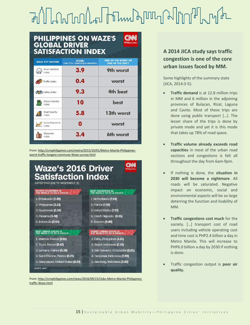
15 | S u s t a i n a b l e U r b a n M o b i l i t y — P h i l i p p i n e C i t i e s ’ I n i t i a t i v e s
From: http://cnnphilippines.com/metro/2015/10/01/Metro-Manila-Philippines-
worst-traffic-longest-commute-Waze-survey.html
From: http://cnnphilippines.com/news/2016/09/15/Cebu-Metro-Manila-Philippines-
traffic-Waze.html
A 2014 JICA study says traffic
congestion is one of the core
urban issues faced by MM.
Some highlights of the summary state
(JICA, 2014:3-5):
Traffic demand is at 12.8 million trips
in MM and 6 million in the adjoining
provinces of Bulacan, Rizal, Laguna
and Cavite. Most of these trips are
done using public transport […]. The
lesser share of the trips is done by
private mode and yet it is this mode
that takes up 78% of road space.
Traffic volume already exceeds road
capacities in most of the urban road
sections and congestions is felt all
throughout the day from 6am-9pm.
If nothing is done, the situation in
2030 will become a nightmare. All
roads will be saturated. Negative
impact on economic, social and
environmental aspects will be so large
deterring the function and livability of
MM.
Traffic congestions cost much for the
society. […] transport cost of road
users including vehicle operating cost
and time cost is PHP2.4 billion a day in
Metro Manila. This will increase to
PHP6.0 billion a day by 2030 if nothing
is done.
Traffic congestion output is poor air
quality.
16 | S u s t a i n a b l e U r b a n M o b i l i t y — P h i l i p p i n e C i t i e s ’ I n i t i a t i v e s
3.2.2 Philippine Modes of Transport
The Philippines’ transport sector is home to different modes of transport. There are jeepneys,
tricycles, buses, taxis, cars, add to these electric vehicles and car servicing ride-hailing apps. Aside from
motorized transport, there are also non-motorized modes of transport in the country. These include walking,
cycling, rickshaws, pedicabs, among others. These NMTs “…do not damage the environment directly and [are]
a healthy form of transport61.” Excluding MTs and NMTs, there also are alternative modes of transport that
run on electricity and clean fuel. Further, water-based transport are used as well.
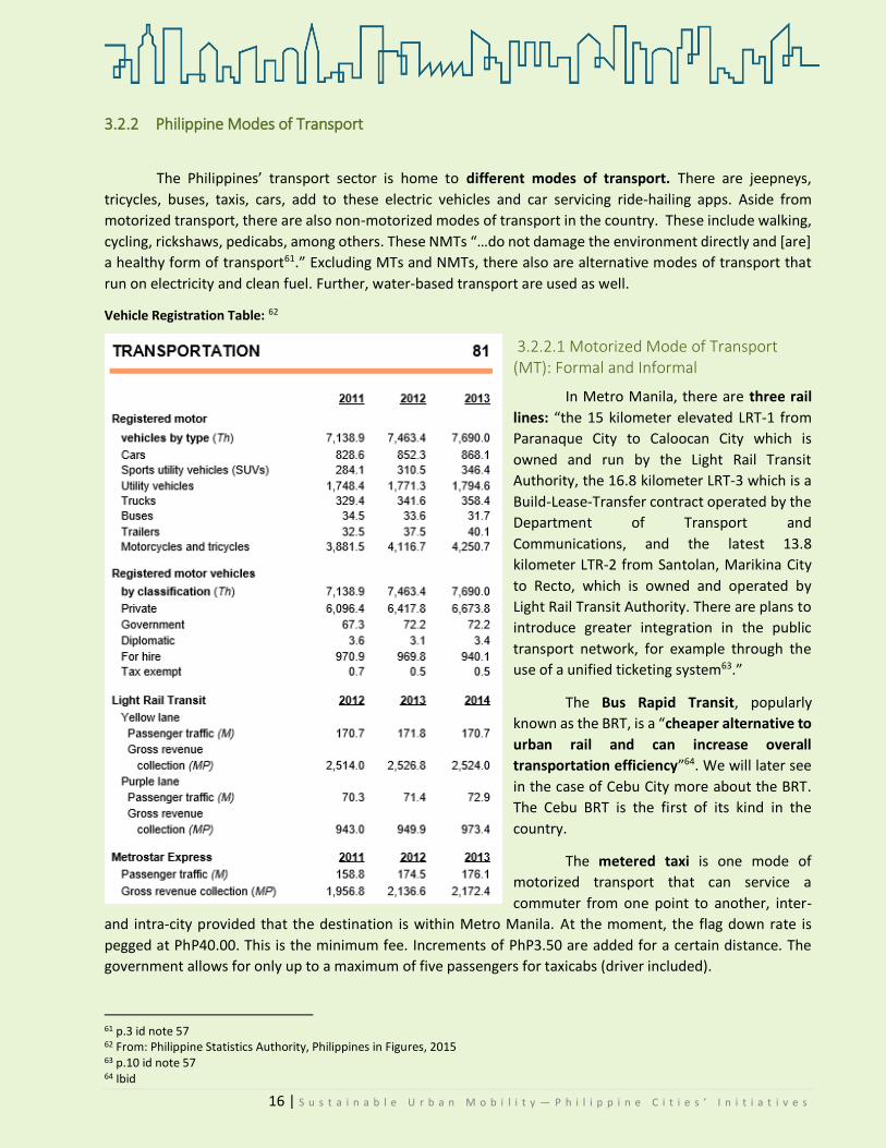
Vehicle Registration Table: 62
3.2.2.1 Motorized Mode of Transport (MT): Formal and Informal
In Metro Manila, there are three rail
lines: “the 15 kilometer elevated LRT-1 from
Paranaque City to Caloocan City which is
owned and run by the Light Rail Transit
Authority, the 16.8 kilometer LRT-3 which is a
Build-Lease-Transfer contract operated by the
Department of Transport and
Communications, and the latest 13.8
kilometer LTR-2 from Santolan, Marikina City
to Recto, which is owned and operated by
Light Rail Transit Authority. There are plans to
introduce greater integration in the public
transport network, for example through the
use of a unified ticketing system63.”
The Bus Rapid Transit, popularly
known as the BRT, is a “cheaper alternative to
urban rail and can increase overall
transportation efficiency”64. We will later see
in the case of Cebu City more about the BRT.
The Cebu BRT is the first of its kind in the
country.
The metered taxi is one mode of
motorized transport that can service a
commuter from one point to another, inter-
and intra-city provided that the destination is within Metro Manila. At the moment, the flag down rate is
pegged at PhP40.00. This is the minimum fee. Increments of PhP3.50 are added for a certain distance. The
government allows for only up to a maximum of five passengers for taxicabs (driver included).
61 p.3 id note 57 62 From: Philippine Statistics Authority, Philippines in Figures, 2015 63 p.10 id note 57 64 Ibid

17 | S u s t a i n a b l e U r b a n M o b i l i t y — P h i l i p p i n e C i t i e s ’ I n i t i a t i v e s
Then, there are also buses that ply long distances. One can go from Manila City to Fairview, Quezon
City by riding a bus. The minimum fare is usually at PhP9.00.
Buses can service more than forty passengers in one trip.
Excluding these, we also have informal motorized
transport. The country is home to the iconic jeepney, which
is a countrywide mode. Unlike taxis, which can take you to
any point in Metro Manila, jeepneys ply particular, definite
routes, depending on their locality. While they have exact
routes, they can, however, also be rented for private
purposes65. The average-sized jeepney can seat about 18-20 passengers. These run on diesel or unleaded gas.
Although recently, LPG gas-run vehicles have also been plying routes in the country.
Similar to the jeepney are vans or AUVs that service commuters to certain routes. For instance, from
SM Fairview, one can go to SM North, or to SM Manila. These are usually called “FX,” since the pioneer vehicles
than ran these trips were mostly Tamaraw FX models. One FX can seat up to eleven people, driver counted in.
The most common informal motorized transport for short distances is the tricycle. These tricycles
especially run routes that are in the inner parts of the barangays. A typical tricycle can seat up to four or five
passengers, including the driver.
Hierarchy of minimum fares (cheapest to most expensive):
Hierarchy of public transport modes based on seating capacity (least to most):
3.2.2.2 Non-Motorized Modes of Transport (NMT)
“Pedicabs” (local term of cycle rickshaws) are one of the NMTs more commonly found all over the
country. They ply the routes of “narrow streets” where jeeps and buses cannot enter. Usually, these serve
short-distance trips.
In the country, Marikina City has introduced a “pedestrian and bikeway system that is not only a safer
transportation scheme than private transport but may also facilitate better people-to-people interaction on a
more human scale66.” The Marikina Program was also successfully replicated by Pasig City. Other notable NMTs
are featured in the immediately succeeding section.
65 Ibid, p.14. 66 Id note 55, p.33.
Trike, Taxi
FX Jeep Bus
Jeep (Php8), Bus (Php9) Trike, FX (Php10) Metered Taxi (Php40)
In the country, not all cities have taxis.
Only the HUCs of Metro Manila, Baguio,
Cebu, Davao, and recently Naga, Bicol do.

18 | S u s t a i n a b l e U r b a n M o b i l i t y — P h i l i p p i n e C i t i e s ’ I n i t i a t i v e s
Despite the promising environmental implications of using NMTs, it is not unusual for governments
‘…to give priority to developing infrastructure that support long-distance and high-speed travel’67 for economic
development.
Notwithstanding the mode of transport, many local government units have taken steps to create a
separate, dedicated body to regulate affairs of the local transport sector and oversee the implementation of
traffic policies. In Cebu City, a City Traffic Management Coordination Committee (CITOM) was constituted. The
same was done in Pasig, where there now is the City Traffic Planning Management Office (CTPMO). Lastly, but
not the least, Baguio City has also recently organized a City Traffic and Transportation Management Office
(CTTO). It previously existed as a mere committee under the City Planning and Development Office.
With both motorized and non-motorized modes of transport increasing in operation, various
suggestions as to how the traffic crisis can be managed have been proposed, to wit68:
Out of its commitment to promote sustainability, the Philippine government has formulated the National
Environmentally Sustainable Transport (NEST) Strategy. The submissions above can also be located in the final
version of the NEST.
67 Id note 55, p.6. 68 Id note 55, p.56-57.
measures including legislations and incentives should be considered to enable a greater buying in of the new
technology. Strategies to encourage efficient use of fuels should be considered.
shar[ing] information and best practices, especially those concepts that are relevant to the region. In order to achieve this, there is a need for greater study and
research on transportation sustainability in the region
urban transportation policies and practices should promote the use of public transportation. [...] the public
transportation infrastructure should facilitate travel convenience and comfort, e.g. through integrated
ticketing and integrated transfers.
NMT should be incorporated in urban transportation plans. In high-density urban areas, there are many short
trips which can be accomplished without the assistance of motorized vehicles.[...]
transportation planning should be integrated with land-use planning—such that Developments should be sited to
minimize trips and/or to shorten trip length.
considerations to restrict private vehicle usage should be given priority as a planning policy rather than as a knee-
jerk reaction to tackling congestion.
19 | S u s t a i n a b l e U r b a n M o b i l i t y — P h i l i p p i n e C i t i e s ’ I n i t i a t i v e s
3.3 Formulation of a National Environmentally Sustainable Transport Strategy
nvironmentally Sustainable Transport (EST) is “transport development that meets the needs of the
present without preventing future generations from meeting their needs.”69 Before delving into the
general idea of the NEST Strategy, let us have a recapitulation of the country’s commitments
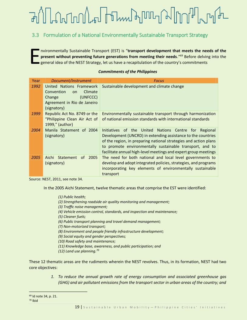
Commitments of the Philippines
Year Document/Instrument Focus
1992 United Nations Framework Convention on Climate Change (UNFCCC) Agreement in Rio de Janeiro (signatory)
Sustainable development and climate change
1999 Republic Act No. 8749 or the “Philippine Clean Air Act of 1999,” (author)
Environmentally sustainable transport through harmonization of national emission standards with international standards
2004 Manila Statement of 2004 (signatory)
Initiatives of the United Nations Centre for Regional Development (UNCRD) in extending assistance to the countries of the region, in preparing national strategies and action plans to promote environmentally sustainable transport, and to facilitate annual high-level meetings and expert group meetings
2005 Aichi Statement of 2005 (signatory)
The need for both national and local level governments to develop and adopt integrated policies, strategies, and programs incorporating key elements of environmentally sustainable transport
Source: NEST, 2011, see note 34.
In the 2005 Aichi Statement, twelve thematic areas that comprise the EST were identified:
(1) Public health; (2) Strengthening roadside air quality monitoring and management; (3) Traffic noise management; (4) Vehicle emission control, standards, and inspection and maintenance; (5) Cleaner fuels; (6) Public transport planning and travel demand management; (7) Non-motorized transport; (8) Environment and people friendly infrastructure development; (9) Social equity and gender perspectives; (10) Road safety and maintenance; (11) Knowledge base, awareness, and public participation; and (12) Land use planning.70
These 12 thematic areas are the rudiments wherein the NEST revolves. Thus, in its formation, NEST had two
core objectives:
1. To reduce the annual growth rate of energy consumption and associated greenhouse gas
(GHG) and air pollutant emissions from the transport sector in urban areas of the country; and
69 Id note 34, p. 21. 70 Ibid
E

20 | S u s t a i n a b l e U r b a n M o b i l i t y — P h i l i p p i n e C i t i e s ’ I n i t i a t i v e s
2. To achieve sustainable mobility through the development of a viable market for
environmentally sustainable transport (EST) goods and services, which includes promoting
transportation systems of low carbon intensity and shifting towards the use of more
sustainable transport modes.71
This was pursuant to a 2009 administrative order (AO 254, 30 Jan 2009)72 of then President Gloria
Macapagal-Arroyo, mandating the DOTC to lead in formulating a NEST for the country. The NEST strategy was
intended to make the Philippines’ transport policies “…into more people- and environment-friendly ones and
to contribute to achieving the Sustainable Transport Goals set forth in the Bangkok 2020 Declaration.73”
In connection with the execution of its commitment, the University of the Philippines’ National Center
for Transportation Studies (UP-NCTS) for Regional Development was designated as the National Collaborating
Center for the NEST formulation74. The outcome document, which was a strategy—cum-action-plan, was
intended to bridge the gap between and among local, national, and international initiatives that relate to EST.
There was a call for a NEST because the status quo strategy was no longer as effective and efficient as
it was envisioned to be.
What, then, sets the EST apart from the conventional approaches to transport planning and policy
development?
EST Conventional approaches Goals are consistent with sustainable development (pro-active)
Goals “are more for mobility and accessibility with mitigating measures prescribed to counter-act possible negative externalities of the resulting transport system, in short reactive”
Views negative externalities in its entirety Tend to focus on mitigation of environmental impacts per transport activity unit
Recommended policy instruments are aimed at restraining growth in the most environmentally damaging forms of transport activity.
Content based on: NEST, 2011, see also note 34.
As the circumstances change, so should the actions of the government. In addressing transportation and other
mobility issues, there is no one-size-fits-all solution. The government must adapt to the needs and demands
of the time, instead of imposing one solution if it has already served its purpose, or if it has already exhausted
its positive effects.
71 UN Center for Regional Development, at: http://www.uncrd.or.jp/index.php?page=view&type=13&nr=21&menu=232 72 The AO can be viewed in the Official Gazette’s website, at: http://www.officialgazette.gov.ph/2009/01/30/administrative-order-no-254-s-2009/ 73 an important regional consensus agreed upon at the Fifth Regional EST Forum in Asia held in August 2010. .” Ibid. 74 p.3-11, id note 55

21 | S u s t a i n a b l e U r b a n M o b i l i t y — P h i l i p p i n e C i t i e s ’ I n i t i a t i v e s
Other national strategies of the government include spending on transportation infrastructure.
Through the Department of Public Works and Highways (DPWH), the national government intends to spend
on the following programs75:
Program Cost Actions
Traffic Decongestion Program
P107.8B Construction/ widening of national roads and bridges; construction of by-passes/diversion roads, flyovers, interchanges, and underpasses
Integrated and Seamless Transport System
P95.9B Construction/ improvement of logistics infrastructure network in Northern Mindanao, Davao, SOCSARGEN and CARAGA (MLIN); Construction/ improvement of roads leading to growth corridors in Western Mindanao; Studying and implementation of Inter-island linkage projects through long-span bridges; Connection of gaps along national roads; Construction/replacement of bridges; Initiation of studies on tunneling technology)
Public-Private Partnership Program
--- Augmentation and complementing of locally-Funded and foreign-Assisted projects; Construction of high standard highway network based on Master plan and Technical Studies
Convergence and Rural Road Development Program
P18.8B Construction/upgrading of local access roads to designated tourism destinations, RORO ports / seaports and airports; Construction of Farm to Market Roads (FMRs); Construction/improvement of roads leading to industrial trade corridors.)
Livable, Sustainable and Resilient Communities
P104.4B Create Environment-Friendly Communities (Building of more bike lanes and pedestrian infrastructure.)
In a similar line, the DOTr is also now investing in a road-based public transport reform program. Its
components include the PUV Modernization Program, the Integrated Terminal Exchange, the Bus Rapid Transit
System, and the Intelligent Transport System.76
75 Data from the DPWH presentation, ‘DPWH Strategic Infrastructure Programs and Policies’ on the occasion of the 24th Annual Conference of the Transportation Science Society of the Philippines; 21 July 2017. 76 Ibid

22 | S u s t a i n a b l e U r b a n M o b i l i t y — P h i l i p p i n e C i t i e s ’ I n i t i a t i v e s
CRITERIA FOR CASE STUDY
This year’s One Planet City Challenge theme revolves on
sustainable mobility. Sustainable mobility, according to the World
Business Council for Sustainable Development, is “the ability to meet
the needs of society to move freely, gain access, communicate,
trade, and establish relationships without sacrificing other essential
human or ecological values today or in the future77.”
4.1 Selecting Cities There are many Philippine cities that advance and have
forwarded initiatives promoting sustainable transportation and
mobility. However, to narrow down the selection, it was necessary to select only a few whose initiatives can
be adequately captured in a case study. Cities to be visited were selected based on the criteria described
below. For this case study, cities must exhibit at least five of the criteria. Though, it must be pointed out that
the cataloguing of homegrown initiatives is initiative-based, and not city-based.
The cities that were rated in this section were selected based on the availability of data on the Internet.
Those cities with the most available data for desk research were counted in.
Of the seven cities identified, only five were qualified for visitation based on the criteria. A caution,
however, is—the assessment was based on the available data gathered through online research. The gauge
range was set from “high” to “marginal.” Performances of cities in a specific criterion, which were unavailable,
were classified as “open” and rated 0. The rankings are as follows:
1. Marikina City 2. Pasig City 3. Baguio City 4. Vigan City 5. Cebu City 6. San Fernando City 7. Muntinlupa City 8. Mandaluyong City Marikina, Pasig, and Vigan are the only cities that have approved initiatives that are all being
implemented. Baguio has the most number of identified initiatives, but not all are approved. Half are pending
proposals that have gone through the phase of public presentation. Vigan, on another note, has the most
number of approved initiatives that have been carried out for more than a decade now. Cebu City is a
recipient/host of a pending project set for implementation.
Other cities were personally visited, too, due to supervening circumstances. These are Muntinlupa and
Mandaluyong City. Explanations are laid out in the succeeding sections of this study. Thus, a total of seven
77 Id, note 1
23 | S u s t a i n a b l e U r b a n M o b i l i t y — P h i l i p p i n e C i t i e s ’ I n i t i a t i v e s
cities (Vigan, Baguio, Cebu, Marikina,
Pasig, Mandaluyong, and
Muntinlupa) were personally visited.
The rest of the cities whose initiatives
are discussed briefly in succeeding
sections were not visited, but data
were gathered from both published
primary and secondary sources.
4.2 Data Gathering
Framework
The end goal of the research
is to compile into a single index the
homegrown initiatives of different
Philippine cities that focus on
sustainable transport and mobility.
Public acceptability shall be the
measure for evaluating the initiative’s
social impact. It is necessary to link
the social impacts of government
initiatives to the acceptance of the
public as it can help in determining
points for improvement. For the
purpose of this case study, impacts
shall be taken to mean “…positive,
negative, or neutral changes in social,
economic, or political structures that
will be caused by a proposed action.
They can occur over space and
time79”. However, what will also be
evaluated are approved and
implemented actions/initiatives.
The target sample is
composed of two major sets of
interviewees: one from the local
government unit and another from
the public.
78 The data gathering framework and methodology were abridged for ease of reading of this case study.) 79 p.2, Babiuch, WM and BC Farhar. (1994). Stakeholder A Methodologies Resource Book. Colorado, USA: National Renewable Energy Laboratory.
CRITERIA. Cities must:
1. Build a conducive setting for governance through sharing of resources,
responsibilities, and risks;
The government must spread its resources squarely among
departments. For sustainable city planning, all departments must
give their outputs so that not only is each of them a part of the
process, each can also be held liable for their actions. Data
sharing among departments should also be encouraged. With
regard to risk, it is likewise vital that all departments of the
government be aware of their responsibilities and the risks the
city can face should they not do their jobs.
2. Adopt an inclusive city agenda integrating transport, public utilities,
employment, and social welfare policies;
Sustainable mobility is not just about cars, motorcycles, or
jeeps. It also includes pedestrians. For that reason, there must be
an integration of transport mobility management in city land use
plans. It is central that there be doable and achievable goals that
cities have to meet from time to time. Transport policies affect
the delivery of basic social services, the environment,
employment, and utilities.
3. Promote a sharing of public spaces between pedestrians and motorists
(encourage the use of public transport);
Streets are public goods. They are characterized by non-excludability and non-rivalry. That means that no one is excluded from enjoying it and the use of person A of the street will not deprive person B of enjoying the same. Ideally, at least, that is what streets and roads are. Thus, it is important in the spirit of sustainable mobility that cities mediate the use of streets and roads between pedestrians and motorists. This can be done through a repurposing of roads, creation of city road network plans, pedestrianization, inter alia.
4. Manage mobility in conjunction with environmental quality;
Cities must foster ecological integrity by safeguarding that home-
grown bionetworks are not exploited or destroyed by
infrastructural transport initiatives. While putting up transport
infrastructure is laudable, it is imperative that it does not
jeopardize natural habitats and does not add to the emission of
harmful greenhouse gases. City initiatives should always..
24 | S u s t a i n a b l e U r b a n M o b i l i t y — P h i l i p p i n e C i t i e s ’ I n i t i a t i v e s
Why is there a need to collate even the
responses of the people? All projects, activities,
and programs (PAPs) of the government must
always be consulted with the people. Whether
they are proposed or already implemented,
stakeholder consultation is cardinal for good
governance. This is so because as stakeholders,
they are the ones who will be directly affected by
the proposed PAP of the government. The
opinions of the stakeholders will either validate
or invalidate the initial findings of the desk
research. Moreover, their opinions can elicit
“valuable” material that can serve as a basis for
“developing acceptable outcomes that can be
implemented effectively and efficiently.”
1. Local Government Unit representatives—At
least one official from each city shall be
interviewed. The official must be directly
concerned with the operations and
implementation of the featured initiative.
2. Public—The public set is further divided into
two: the commuting public and the motor
drivers/operators.
It is important to point out the difference
between informants and respondents as the
distinction has an implication on the processing
of data and interpretation of findings. For
purposes of this research, “informant” shall mean
“…an individual answering questions about the
beliefs, positions, and behavior of a stakeholder
group, an organization, or some other group or
aggregate, speaking from a position of
membership in the group, organization, or
aggregate80.” Informants are those from the
LGU. On the other hand, “respondent” shall mean
“…an individual answering questions about his or
her personal opinions, beliefs, knowledge, values,
attitudes, and behavior81.” The respondents,
then, are those from the affected public.
There must be diversity in the informants
and respondents to have a higher degree of
80 Ibid 81 Id note 80, p. 43
…factor in the environmental dimension. Cities should
campaign for alternative fuels and non-motorized
transportation.
5. Construct transport infrastructure, while providing a range of modal
choices to inhabitants*;
Whereas soft programs adopting sustainable mobility are
appreciated and needed, hard projects or infrastructures are
essential, too. They lay down the foundation for urban mobility.
If there were no stations for trains, there would be traffic chaos.
If there were no charging stations, electric vehicles such as e-
trikes and e-jeepneys would be an impractical alternative to
other gas-emitting motorized transport. Cities should then put
up transport infrastructure tailored to pedestrian traffic for
sustainability. If inhabitants are given more options for
transport, traffic easement would follow. If possible, new roads
can be constructed based on pedestrian behavior. Bike lanes,
strategic bus stops, among others can also be created.
*with the exception of Mandaluyong and Cebu City, as shall
be discussed later.
6. Translate into policy principles of sustainability while supporting the
economy; and
Cities should translate to legislative measures and other
policies sustainable urban mobility principles. Said policies
should not endanger the economy and should as much as
possible, not dislocate people from their jobs. Sustainable
mobility initiatives must similarly take into consideration the
economic implications of shifting from motorized
transportation to non-motorized transportation and
pedestrianization. The city should be prepared to cover the
costs of the shift.
7. Value public involvement, transparency, and accountability.
Initiatives of cities must link people and communities
together. Public acceptance is a critical component of city
initiatives in the same manner that public involvement is. The
greater the involvement of stakeholders in the introduced
programs/projects, the greater the acceptance. These
programs/projects have costs, which even with financial
support from non-/government agencies, which will be passed
on to the commuting public. These should be kept at rates
affordable to the average Filipino. Whatever expense was made
in the pursuit of the programs/projects must be disclosed and
the city must be ready to answer for any damages that may be
incurred in the execution.

25 | S u s t a i n a b l e U r b a n M o b i l i t y — P h i l i p p i n e C i t i e s ’ I n i t i a t i v e s
validity of the results. They will be differentiated according to age, sex, and socio-economic status. These will
give an idea of the target sample demographics.
4.3 Case Methodology
Fieldwork was done on the following dates: Vigan City on August 14-15, 2017; Baguio City on August 16-18 and September 1, 2017; Cebu City on August 23-25, 2017; Pasig City on August 27 and September 4, 2017; Marikina City on September 13, 14, and 18, 2017; Mandaluyong City on September 14,15, and 18, 2017; and Muntinlupa City on October 2, 2017.
During the site visitation, initial findings from the desk research were presented to local government
units for them to confirm or dispute points taken from the review of related literature, studies, and online news reports. Subsequent findings shall be presented to the LGU through the polished output of the research.
For veracity, a triangulation of data gathering methods was done through the following: 1. Document Analysis—Primary data were derived from official records such as those from
national agencies (e.g. the Philippine Statistics Authority, national policies), the local
government units of each city (e.g. local ordinances and orders), and other published materials
(e.g. from ADB, WB, WBSCD, etc.).
2. Interview—General interviews were conducted with respondents who were among those
affected by the initiative/s in focus. For instance, in Cebu, this was done for the riding public
who will be affected by the BRT. In Vigan, it was done for the business owners and tricycle
drivers.
3. Key Informant Interview—KII was done with the LGU representatives. This varied from city to
city, depending on which agency was in charge of the implementation.
The criteria ratings of each city are illustrated below.
Gauge range:
High (5)—Has legislative measures and institutionalized practices
Moderate (3)—Has legislative measures and proposed practices; OR has proposed measures
and institutionalized practices
Marginal (1)—Has no legislative measures yet, but have proposals from the city government;
and has proposed practices
Open (0)—Cannot gauge the city’s performance at the moment with the available data.

26 | S u s t a i n a b l e U r b a n M o b i l i t y — P h i l i p p i n e C i t i e s ’ I n i t i a t i v e s
Criteria Rating
A B C D E F G H
Build a conducive setting for governance through sharing of resources, responsibilities, and risks;
Open 0
Mod. 3
Open 0
Open 0
Mod. 3
High 5
Open 0
High 5
Adopt an inclusive city agenda integrating transport, public utilities, employment, and social welfare policies;
High 5
High 5
Mod. 3
Mod. 3
High 5
High 5
Open 0
High 5
Promote a sharing of public spaces between pedestrians and motorists (encourage the use of public transport);
High 5
Mod. 3
Marg. 1
High 5
Mod. 3
High 5
Marg. 1
High 5
Manage mobility in conjunction with environmental quality;
High 5
High 5
High 5
Mod. 3
Mod. 3
High 5
High 5
High 5
Construct transport infrastructure, while providing a range of modal choices to inhabitants;
Marg. 1
Marg. 1
Open 0
Mod. 3
Marg. 1
Marg. 1
Open 0
High 5
Translate into policy principles of sustainability while supporting the economy; and
Mod. 3
Mod. 3
High 5
Open 0
Mod. 3
High 5
Mod. 3
Mod. 3
Value public involvement, transparency, and accountability.
High 5
High 5
Open 0
High 5
Open 0
Open 0
Open 0
Mod. 3
# of criteria present in each city 6 of 7 7 of 7 4 of 7 5 of 7 6 of 7 6 of 7 3 of 7 7 of 7
TOTAL POINTS 24 25 14 19 18 26 9 31
RANK 4 3 7 5 6 2 8 1
Qualified
Disqualified
As an interview tool/instrument, a focused interview questionnaire was used. It is a focused, semi-
structured set of questions aimed at gathering qualitative data on (a) the LGU’s planning and implementation
perspectives, and (b) the social acceptability of the public. By semi-structured, it means that questions can
have more follow-ups, provided that they relate to the topic.
A - Vigan City C - San Fernando, LU E - Muntinlupa City G - Mandaluyong CIty
B - Baguio City D - Cebu City F - Pasig CIty H - Marikina City

27 | S u s t a i n a b l e U r b a n M o b i l i t y — P h i l i p p i n e C i t i e s ’ I n i t i a t i v e s
For the LGU informants
Topical Focus Questions
Initiatives 1. What are your initiative/s that focus on sustainable mobility?
Rationale 2. What is the rationale behind the initiative/s / project/s?
Funding 3. Did your LGU receive help (non-/financial) from inter-/national agencies/organizations? To what extent was it useful in the implementation of the initiative?
a. If not, did the LGU fully fund the initiative? Was it all from the IRA? Or was it pooled from the resources of concerned departments?
Challenges 4. What challenge/s has/have beset the (a) planning and (b) implementation of the initiative/s?
5. What additional resource/s do you need to have a better implementation?
Social acceptability
6. In your professional official capacity, how will you gauge the public’s acceptance of the initiative/s (rate from 1-lowest to 5-highest)?
For the public respondents
Topical Focus Questions
Social benefit and acceptance
1. Does the project/initiative benefit you? (Y-in what way/s?; N-why not?) 2. Has the implementation of the initiative affected your daily affairs [as
compared to how things were prior to the implementation]? (Y-in what way/s?; N-why not?)
Challenges 3. What do you think are the challenges that beset the implementation?
Recommendations
4. What recommendations can you extend to the LGU to make the project/initiative better?
5. [if the initiative has adverse effects] What recommendations can you give to mitigate the negativities of the initiative/s?
During the interview, for ethical considerations, the following were explained to the respondents: (a)
the research overview, (b) the goals of the research, (c) the purpose of the research, (d) the implications of
participating in the research, and (e) the disposition of the final output of the research.
The data were collated, organized, and processed with respect to the particular contexts in which they
were gathered. They are presented in the subsequent section.

28 | S u s t a i n a b l e U r b a n M o b i l i t y — P h i l i p p i n e C i t i e s ’ I n i t i a t i v e s
CITIES’ HOMEGROWN INITIATIVES
hat do cities do to manage urban mobility in such a way
that it becomes sustainable? Cities come up with ‘policies
and investments that shift automobile travel to public
transport, cycling and walking which all contribute substantially to
building more sustainable and inclusive cities.82
As explained in the previous discussion on the One Planet
City Challenge, homegrown initiatives of cities that focus on
sustainable mobility will be featured. By “homegrown,” what is
meant is that these initiatives are funded from local sources—or from
the local government’s funds. This is, however, with the exception of
Cebu City and Mandaluyong City, which are both recipients of pilot
projects of the World Bank and the Asian Development Bank, respectively.
After organizing and processing the data gathered from the fieldwork, a summary reading of the
identified initiatives of each city shows that there are common programs/projects among cities, albeit with
different names. To visualize the commonalities:
It appears that among common initiatives,
walkability and implementation of carless
days are the most shared among cities. Next
are the alternative modes of transport.
Then comes mass transport. Among other
uncategorized initiatives are soft programs.
These include loan schemes and
information campaigns.
The initiatives lumped in the
“others” category involve those that are not
shared among cities, or those that are
unique in this set of cities. For instance, only
Baguio has a total tricycle ban in the entire
city. It also is the only city that bans
motorcycles in the entire stretch of Session
Road, and that bans PUJs from plying routes
in the Central Business District. Cebu, on the
other hand, is the only city that has a Bus Rapid Transit System in tow. A more elaborate discussion follows. It
should be noted that most of the transport initiatives are land-based with very few water-based transport
coming out of the research and discussion.
82 P. 93 PROMOTING SUSTAINABLE TRANSPORT FOR INCLUSIVE DEVELOPMENT PROMOTING SUSTAINABLE TRANSPORT FOR INCLUSIVE DEVELOPMENT
W
Walkability and Carless
Days
Mass Transport
Alternative Modes of Transport
Others
City Initiatives
Walklability andCarless Days
Mass Transport
Alternative Modes ofTransport
Others

29 | S u s t a i n a b l e U r b a n M o b i l i t y — P h i l i p p i n e C i t i e s ’ I n i t i a t i v e s
Before delving into the specifics, it is but proper to have an introduction to Philippine cities. The
Philippines has three kinds of cities. These are highly urbanized cities, independent component cites, and
component cities. 63% of the Philippines’ total population resides in urban areas, according to the UN Data of
2005, thus making it one of the countries with the “highest urbanization rates” in Asia.83
Source: Philippine Statistics Authority
There are a total of 33 highly urbanized cities in the
country. All of them face transportation and
development problems uniquely within their
contexts. 16 of the 33 are in Metro Manila84, or
within the National Capital Region. The rest are
situated in other regions. The “average population
growth rate in metro manila cities was pegged at
1.92%” from 2000-2007, while those outside MM,
at 2.55%.85
WWF firmly believes that Philippine cities are taking initiatives at coming up with transformative
solutions to solve the problem on transportation and mobility. One of the purposes of this study is to showcase
those initiatives which can be replicated by other cities both national and international, as part of the shift
towards a more sustainable management of cities and mobility.
83 p. 2-1, id note 55 84 ibid 85 p. 2-3, id note 55

30 | S u s t a i n a b l e U r b a n M o b i l i t y — P h i l i p p i n e C i t i e s ’ I n i t i a t i v e s
There is a quick reference matrix of the highlighted
initiatives taken by various local government units. These are
either ongoing or pending programs/activities/projects
(PAPs), with the exception of Mandaluyong City and San
Fernando, whose featured programs have since been
discontinued but still merit discussion. The matrix of
initiatives can be viewed in the next page. What follows in the
next section is a more in-depth discussion of initiatives.
As discussed in the Chapter on methodology, the
cities were selected based on desk research and set criteria.
Seven cities were personally visited for data gathering. Data
for the rest of the cities whose initiatives are part of this study
were gathered through desk research.
5.1 Categories of City Initiatives Initiatives were grouped into larger categories so that
they could be appreciated better. The four categories are
(a), Pedestrianization, Walkability & Green Spacing,
(b) Mass Transport, (c) Alternative Modes of Transport, and
(d) Institutional policies.
The first category includes those initiatives focused
on promoting walking to reduce emissions. This includes
carless days and pedestrianization with examples from the
cities of Vigan, Pasig, and Makati are included here. It also
includes green spaces to encourage walking. The featured
city is the city of IloIlo, whose esplanade has promoted
walkability amongst its residents.
The second category refers to those initiatives which
concentrate on public modes of transport that ply on fixed
routes, such as buses and monorails. This takes account of the
cities of Cebu, whose BRT Project is the first of its kind in the
country. While jeepneys are also classified as mass transport,
the electric jeepneys highlighted are placed under the next
category.
The third is about alternative modes of transport. It
includes electric vehicles and bike programs. This is where the e-trikes and e-jeepneys, which still run on motor
engines but are powered by electricity, come in. Many cities are presented here.
The fourth category is on institutional policies. While mobility initiatives are best expressed in
alternative modes of transport that reduce emissions, policies promulgated by local governments are also
potential contributors to the reduction. Featured is Baguio City.
City Classification
Highly Urbanized Cities - Cities with a
minimum population of two hundred
thousand (200,000) inhabitants, as
certified by the National Statistics
Office, and with the latest annual
income of at least Fifty Million Pesos
(PhP 50,000,000.00) based on 1991
constant prices, as certified by the
city treasurer.
Independent Component Cities -
Cities whose charters prohibit their
voters from voting for provincial
elective officials. Independent
component cities shall be
independent of the province.
Component Cities - Cities which do
not meet the above requirements
shall be considered component cities
of the province in which they are
geographically located. If a
component city is located within the
boundaries of two (2) or more
provinces, such city shall be
considered a component of the
province of which it used to be a
municipality.” Philippine Standard
Geographic Code.
From:http://nap.psa.gov.ph/activestats/psgc
/articles/con_cityclass.asp

31 | S u s t a i n a b l e U r b a n M o b i l i t y — P h i l i p p i n e C i t i e s ’ I n i t i a t i v e s
Initiatives → Walkability Mass Transport
Alternative Modes of Transport
Institutional Policies Cities ↓
Bacoor e-trike fleet service
Baguio Various policies
Cebu BRT Project Bike lanes ordinance
General Santos
HERT
Iloilo Green spaces
Makati e-Jeepney
Mandaluyong e-trike
Manila e-trike
Marikina Bikeways Program
Muntinlupa e-Jeepney
Naga e-trike
Pasig Carless Days and Walkways
Community bus
Bike-sharing, bike lanes
Puerto Princesa
e-trike
San Fernando Green spaces
Vigan pedestrianization Heritage policies
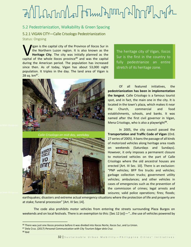
32 | S u s t a i n a b l e U r b a n M o b i l i t y — P h i l i p p i n e C i t i e s ’ I n i t i a t i v e s
5.2 Pedestrianization, Walkability & Green Spacing
5.2.1 VIGAN CITY—Calle Crisologo Pedestrianization Status: Ongoing
igan is the capital city of the Province of Ilocos Sur in the Northern Luzon region. It is also known as the Heritage City. The city was initially planned as the
capital of the whole Ilocos province86 and was the capital during the American period. The population has increased since then. As of today, Vigan has about 53,000 night population. It triples in the day. The land area of Vigan is 28 sq. km87.
Of all featured initiatives, the
pedestrianization has been in implementation
the longest. Calle Crisologo is a famous tourist
spot, and in fact, the main one in the city. It is
located in the town’s plaza, which makes it near
the Church, commercial and food
establishments, schools, and banks. It was
named after the first civil governor in Vigan,
Mena Crisologo, who is also a playwright88.
In 2005, the city council passed the
Transportation and Traffic Code of Vigan (Ord.
27 series of 2005). It bans the passage of all kinds
of motorized vehicles along heritage area roads
on weekends (Saturdays and Sundays).
However, it only imposes a permanent closure
to motorized vehicles on the part of Calle
Crisologo where the old ancestral houses are
erected [Art. III Sec. 10]. There is an exclusion:
“PNP vehicles; BFP fire trucks and vehicles;
garbage collection trucks; government utility
vehicles; ambulances; and other vehicles in
cases of emergencies such as the prevention of
the commission of crimes; legal arrests and
seizures; valid police operations; fires; floods;
earthquakes; disasters and extreme actual emergency situations where the protection of life and property are
at stake; funeral procession” [Art. III Sec.14].
The code also prohibits motor vehicles from entering the streets surrounding Plaza Burgos on
weekends and on local festivals. There is an exemption to this: [Sec 12 (e)]—“…the use of vehicles powered by
86 There was just one Ilocos province before it was divided into Ilocos Norte, Ilocos Sur, and La Union. 87 Dela Crus. (2017) Personal Communication with City Tourism Edgar dela Cruz. 88 Ibid
V The heritage city of Vigan, Ilocos
Sur is the first in the country to
fully pedestrianize an entire
stretch of its heritage zone.
Calle Crisologo on mid-day, weekday
©KCCDYangot/WWF-Philippines
©KCCDYangot/WWF-Philippines
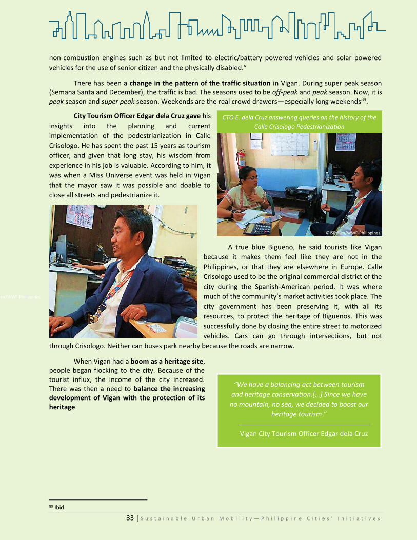
33 | S u s t a i n a b l e U r b a n M o b i l i t y — P h i l i p p i n e C i t i e s ’ I n i t i a t i v e s
non-combustion engines such as but not limited to electric/battery powered vehicles and solar powered
vehicles for the use of senior citizen and the physically disabled.”
There has been a change in the pattern of the traffic situation in VIgan. During super peak season (Semana Santa and December), the traffic is bad. The seasons used to be off-peak and peak season. Now, it is peak season and super peak season. Weekends are the real crowd drawers—especially long weekends89.
City Tourism Officer Edgar dela Cruz gave his
insights into the planning and current
implementation of the pedestrianization in Calle
Crisologo. He has spent the past 15 years as tourism
officer, and given that long stay, his wisdom from
experience in his job is valuable. According to him, it
was when a Miss Universe event was held in Vigan
that the mayor saw it was possible and doable to
close all streets and pedestrianize it.
A true blue Bigueno, he said tourists like Vigan
because it makes them feel like they are not in the
Philippines, or that they are elsewhere in Europe. Calle
Crisologo used to be the original commercial district of the
city during the Spanish-American period. It was where
much of the community’s market activities took place. The
city government has been preserving it, with all its
resources, to protect the heritage of Biguenos. This was
successfully done by closing the entire street to motorized
vehicles. Cars can go through intersections, but not
through Crisologo. Neither can buses park nearby because the roads are narrow.
When Vigan had a boom as a heritage site, people began flocking to the city. Because of the tourist influx, the income of the city increased. There was then a need to balance the increasing development of Vigan with the protection of its heritage.
89 Ibid
“We have a balancing act between tourism
and heritage conservation.[…] Since we have
no mountain, no sea, we decided to boost our
heritage tourism.”
Vigan City Tourism Officer Edgar dela Cruz
CTO E. dela Cruz answering queries on the history of the
Calle Crisologo Pedestrianization
©ISBellen/WWF-Philippines
©ISBellen/WWF-Philippines
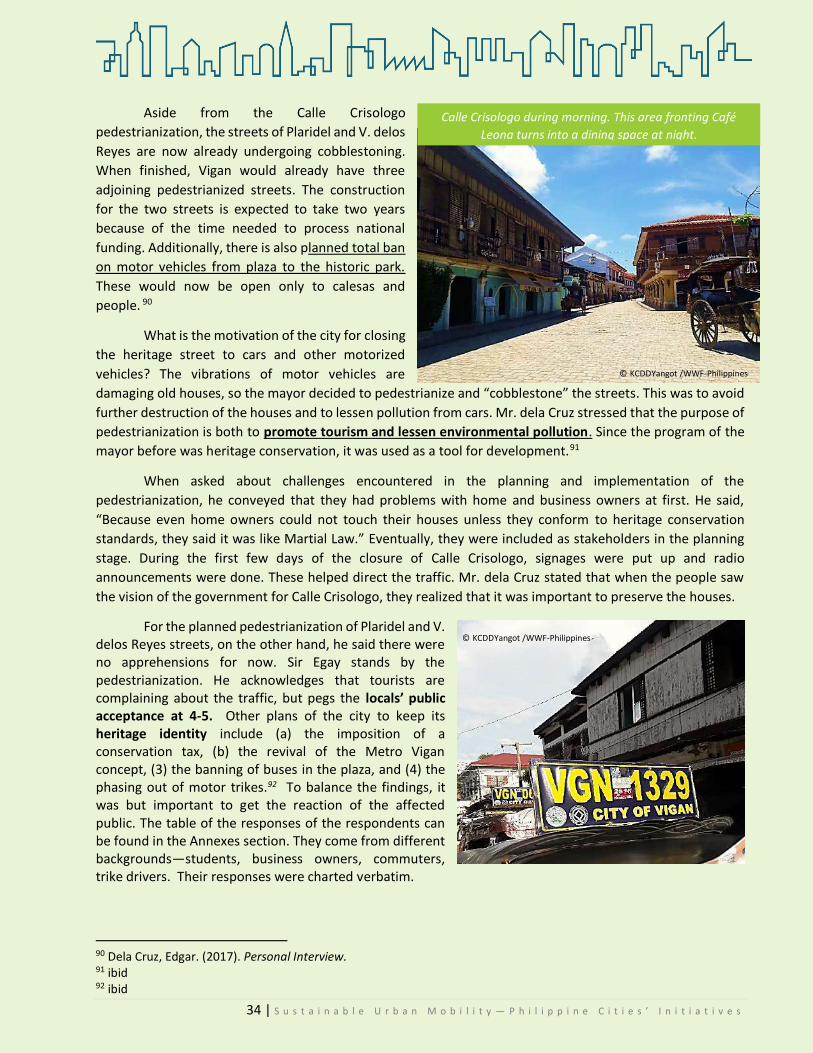
34 | S u s t a i n a b l e U r b a n M o b i l i t y — P h i l i p p i n e C i t i e s ’ I n i t i a t i v e s
Aside from the Calle Crisologo
pedestrianization, the streets of Plaridel and V. delos
Reyes are now already undergoing cobblestoning.
When finished, Vigan would already have three
adjoining pedestrianized streets. The construction
for the two streets is expected to take two years
because of the time needed to process national
funding. Additionally, there is also planned total ban
on motor vehicles from plaza to the historic park.
These would now be open only to calesas and
people. 90
What is the motivation of the city for closing
the heritage street to cars and other motorized
vehicles? The vibrations of motor vehicles are
damaging old houses, so the mayor decided to pedestrianize and “cobblestone” the streets. This was to avoid
further destruction of the houses and to lessen pollution from cars. Mr. dela Cruz stressed that the purpose of
pedestrianization is both to promote tourism and lessen environmental pollution. Since the program of the
mayor before was heritage conservation, it was used as a tool for development.91
When asked about challenges encountered in the planning and implementation of the
pedestrianization, he conveyed that they had problems with home and business owners at first. He said,
“Because even home owners could not touch their houses unless they conform to heritage conservation
standards, they said it was like Martial Law.” Eventually, they were included as stakeholders in the planning
stage. During the first few days of the closure of Calle Crisologo, signages were put up and radio
announcements were done. These helped direct the traffic. Mr. dela Cruz stated that when the people saw
the vision of the government for Calle Crisologo, they realized that it was important to preserve the houses.
For the planned pedestrianization of Plaridel and V. delos Reyes streets, on the other hand, he said there were no apprehensions for now. Sir Egay stands by the pedestrianization. He acknowledges that tourists are complaining about the traffic, but pegs the locals’ public acceptance at 4-5. Other plans of the city to keep its heritage identity include (a) the imposition of a conservation tax, (b) the revival of the Metro Vigan concept, (3) the banning of buses in the plaza, and (4) the phasing out of motor trikes.92 To balance the findings, it was but important to get the reaction of the affected public. The table of the responses of the respondents can be found in the Annexes section. They come from different backgrounds—students, business owners, commuters, trike drivers. Their responses were charted verbatim.
90 Dela Cruz, Edgar. (2017). Personal Interview. 91 ibid 92 ibid
© KCDDYangot /WWF-Philippines
Calle Crisologo during morning. This area fronting Café
Leona turns into a dining space at night.
© KCDDYangot /WWF-Philippines

35 | S u s t a i n a b l e U r b a n M o b i l i t y — P h i l i p p i n e C i t i e s ’ I n i t i a t i v e s
Four general points can be derived from the respondents:
a) The Calle Crisologo pedestrianization is perceived by both
trike drivers and business owners as beneficial. Because it has
become a tourist attraction in itself, more people spend their
money going to and in stores along the stretch of Crisologo.
One of the respondents said that aside from the fact that it
preserves their heritage, the pedestrianization “disciplines
people to walk.”
b) The same is favored by commuters and students because they believe it preserves Vigan’s heritage.
c) The ongoing construction (“cobble stoning”) of
Plaridel and V.delos Reyes are not well-accepted by trike
drivers, vendors, and commuters. This is because they see
it as another looming source of heavy traffic. They do not
think that pedestrianization will solve the congestion
problem. A notable answer from one of the respondents is:
If they will close Plaridel and V. delos Reyes, it would be
difficult for us to service passengers because the closure
would mean we would have to go around so many streets
just to get to the destination. If they will really close
Plaridel, how is that going to be? Along Plaridel Street are
the lumber businesses and along V. Delos Reyes are the
hotels. So how will that be?
d) Even if the pedestrianization of Crisologo is seen as
beneficial, generally, respondents also believe that it is because of the closure that traffic flow is heavy
during peak hours. This is because motorcycles and cars have to go through and around Crisologo just
to get from one point to another, which, in actuality, can be straightly traversed were it not for the
closure. In spite of this general observation, a trike driver conjectured that “what causes traffic is not
the closure of CC but the double parking of cars. There are also a lot of streets being renovated now,
which are supposed to be passageways for trikes and cars.”
As a consequence, though they like the project (cobble stoning) for its effect on heritage preservation and
lessening pollution, they think it just diverts the flow of traffic and does not really solve the problem
Nevertheless, Biguenos are very much in favor of the current policy being implemented in Calle Crisologo.
There are suggestions on improving the current management of Calle Crisologo from the respondents
that are worth quoting, to wit:
"Maybe the government could renovate the dilapidated houses.”
Calle Crisologo is technicolored. "There is yellow, there is pink. On one side, there is a different color.
On the other, there is another. The government should repaint the old houses and existing structures
and impose a uniform, monochromatic theme, preferably a color that is relatable to heritage."
"Maybe the signs can be made bigger, so that tourists can read them properly."
"It would be nice if new attractions would be placed so that tourists could have more to see in the city."
© KCDDYangot /WWF-Philippines
© ISBellen/WWF-Philippines

36 | S u s t a i n a b l e U r b a n M o b i l i t y — P h i l i p p i n e C i t i e s ’ I n i t i a t i v e s
Vigan City remains to be a model city of pedestrianization for all other local government units.
Coupled with political will, the implementation of their policies proves that development can be facilitated
with low carbon emissions. Vigan is evidence that development does not necessarily mean destruction of
nature.
Ongoing construction for the cobble stoning of Plaridel and V. delos Reyes Streets.
© KCDDYangot /WWF-Philippines © KCDDYangot /WWF-Philippines
Two of the trike driver-respondents and one vendor-respondent.
© KCDDYangot /WWF-Philippines © KCDDYangot /WWF-Philippines

37 | S u s t a i n a b l e U r b a n M o b i l i t y — P h i l i p p i n e C i t i e s ’ I n i t i a t i v e s
5.2.2 PASIG CITY—Carless Sundays and Walkability Status: Ongoing
efore it became a highly urbanized city,
Pasig was the capital of the province of
Rizal. It is in fact one of the oldest
towns, aged around 400 years, established by
the Augustinian Friars way back in the 1570s93.
It is popularly known for the Pasig River. It has
a land area of 31 square meters.
With its vision to be a healthy, livable,
and sustainable ecopolis, the city has been
implementing sustainable mobility programs
in addition to its sustainable development
programs. The city identified eight initiatives
on sustainable mobility94.
Two of these are:
1. Carless Sunday Roads/ Share the Road
a. Promote active transport of walking, jogging and biking
b. Implemented and sustained in five major roads for five years
c. 185,000 visitors/ Carless loyalists
d. 360 events/ activities
e. Air-quality improvement by 72%
f. Promotes entrepreneurship, bazaars/ business
g. Promote family and community bonding spirit
2. Pedestrianization and Walkability Promotion
a. 3 kilometers elevated skywalk at City Hall and other buildings
b. 25 Elevated skywalk and walkways at the Pasig CBD/ citywide
c. Provides convenience, connectivity and safety for pedestrians
d. Traffic decongestion
Other related initiatives include:
Odd-Even Traffic Vehicle Volume Reduction Scheme
a. Implemented in six major gateways of the City
b. Reduced travel time from 2 hours to 30 minutes
c. Stabilizes flow of people and vehicles
d. Promote quality time for self and family
e. Vehicle traffic volume reduction by 40%
93 ‘Pasig City History.’ Pasig City Government website. Accessed at: http://www.pasigcity.gov.ph/subpages/about.aspx#page1 94 Data from the CENRO.
B
© KCDDYangot /WWF-Philippines

38 | S u s t a i n a b l e U r b a n M o b i l i t y — P h i l i p p i n e C i t i e s ’ I n i t i a t i v e s
Intelligent Traffic System (ITS)
a. Installed Six LED Monitoring Advisory in strategic areas • Lesser the risk of traffic
accidents/ deaths
b. Installed the system including 82 Road Safety Blinking Solar Pedestrian Lights
c. Safer road for pedestrian/ violators Lesser carbon dioxide emission
To gather data from the LGU, an interview was conducted with the head of the City Environment and
Natural Resources Office. Presently, it is the department in charge of the Carless Day initiative.
CENRO Raquel Naciongayo
he CENRO of Pasig is the implementing arm of the city with regard to sustainable development
programs. They handle the sustainability transport programs, but as Ms. Naciongayo pointed
out, one cannot avoid equating them
with air quality and environmental protection. The city
at present has a newly created CTDMO—City
Transport Development Management Office. Next
year, they will be the one running all traffic-related
programs.
Ms. Naciongayo enumerated the different
programs under their walkability initiative: the
elevated walkways, carless Sundays, and the
promotion of bike use.
For the elevated skywalk and interconnected
walkways, she gave as an example the Ortigas CBD.
According to her, its purpose is to promote
connectivity of buildings, malls, so that it will become
a walkable CBD. Another example she gave was the city
hall area, where there is a “lakable” skywalk to the
church, market, Tanghalang Pasigueno, among others.
Pasig City now has five Carless Sundays, from
its inception in 2012. Every year, the city opens a
different road to this program. Emerald Road has
already been for 5 years. It started in 2012, and three months after, the road in front of City Hall followed suit.
There is another one in MRR Pineda, near the river, which started in 2013. In 2014, the MRR Pineda road
sharing program was launched. The road was shared among people, bikes, and vehicles in the following
portions: 1/3 pedestrian, 1/3 bicycle, and 1/3 for public transport. It is closed to private cars and motorcycles.
Owing to the Pasig senior citizens’ advocacy, the service road Imelda Avenue was included in the carless
Sundays. The CEPMO is now hoping that carless weekends will happen in F. Ortigas.95
95 Naciongayo, Raquel. (2017). Personal Interview.
T
“Sidewalks for the people. We want to
change the mindset from being a car-
centered community back to the basics of
walking. That is the mindset we want---
walkability.”
Raquel Naciongayo, CENRO
“For carless days, there should be
entrepreneurship. So we have bike rentals.
We have bazaars every Sunday. There are
organic vegetables. There is one portion
where there are massagers. In F. Ortigas our
carless is 6am-6pm, so at least the people of
the community can earn from this.”

39 | S u s t a i n a b l e U r b a n M o b i l i t y — P h i l i p p i n e C i t i e s ’ I n i t i a t i v e s
Below is a visualization of the MRR Pineda Road Sharing Program that Pasig implemented.
The CEPM Officer underscored that the walkability initiative of the city is not only for traffic reduction,
but also for mobility. The programs are created for a combination of mobility and traffic decongestion, with a
focus on health. The initiative is fully funded by the city government, in line with its vision to be a green city.
Like any other change, the carless Sunday brought in initial problems. For instance, some building
managers were not prepared for it. It also came to a point where the city was asked to suspend the carless
Sundays because the malls had a sale. Others went as far as challenging the city and looking for the legal basis
of the program. Ms. Naciongayo also said that even some passengers would complain and say, “why close the
road when roads are for cars?” She firmly believes that roads are also for people and not only for cars. Despite
this initial setback, eventually, the mindsets of those affected have been conditioned96.
To end with a good note, when asked to gauge the public’s acceptance of the program, Ms.
Naciongayo said that it was at 5 (out of 5). She said, “if not [5], then all of those projects must have already
died. But since our programs are continuously
implemented and people support it, it is a 5.”
At the end of the interview, Ms. Naciongayo
highlighted that the Pasig government is building the city
not for vehicles, but for the people. She also stated the
future plans of the city: to establish an e-trike service for
barangay and health centers, a cable car system, a river
ferry system (Pasig River Taxi), and a community shuttle
service.
Pasig is a Philippine model city for the successful
implementation of Carless Days. If a highly urbanized city
like Pasig, whose bread and butter lies in its character as
a business district, what more for the other cities?
96 ibid
1/3 pedestrian
1/3 bicycle1/3 mass transport
1 road
(MRR Pineda)
Interview with Ms. Racquel Naciongayo,
CENRO Head, Pasig City.
© KCDDYangot /WWF-Philippines
© KCDDYangot /WWF-Philippines

40 | S u s t a i n a b l e U r b a n M o b i l i t y — P h i l i p p i n e C i t i e s ’ I n i t i a t i v e s
© KCDDYangot /WWF-Philippines © KCDDYangot /WWF-Philippines
Carless Sunday in Emerald Avenue, Ortigas Center
Road Sharing – a portion of MRR Pineda near the Pasig River
© CENRO/Pasig City © CENRO/Pasig City
© KCDDYangot /WWF-Philippines
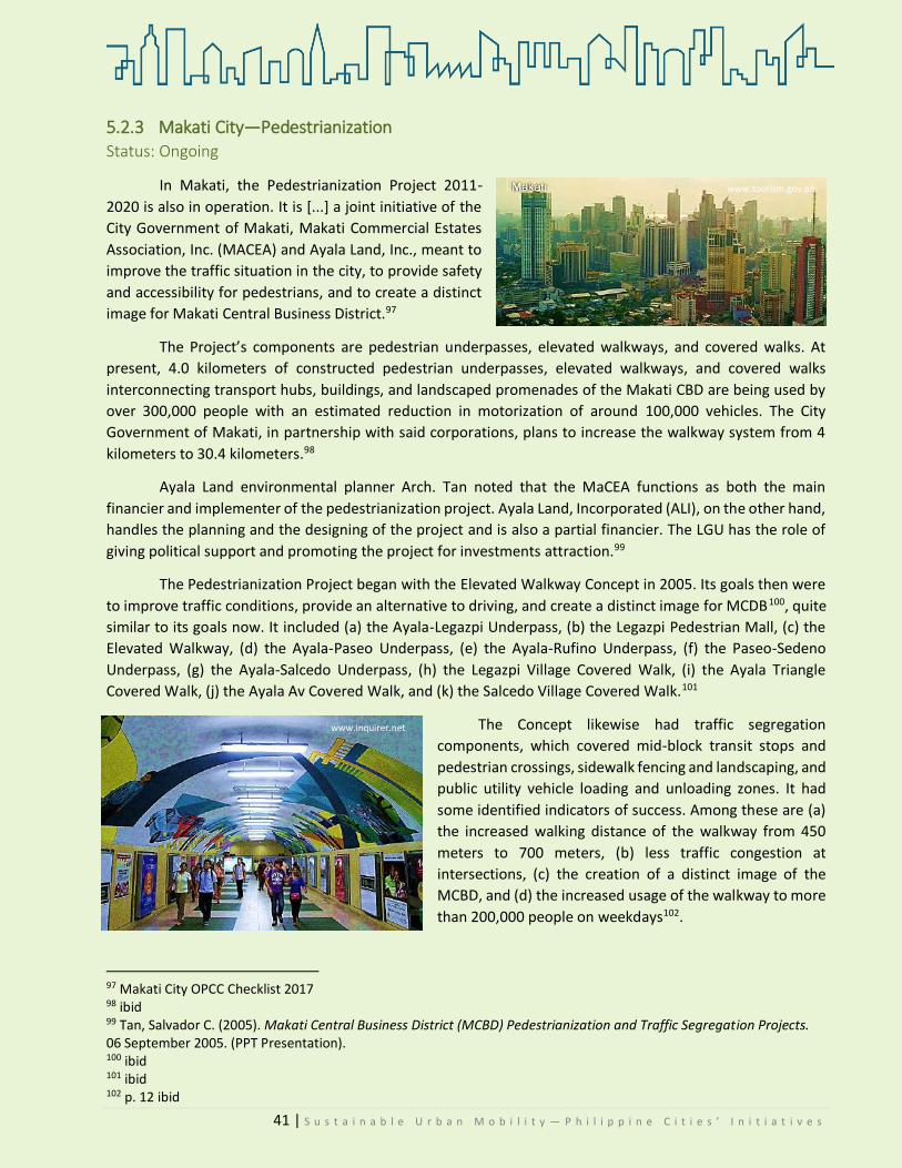
41 | S u s t a i n a b l e U r b a n M o b i l i t y — P h i l i p p i n e C i t i e s ’ I n i t i a t i v e s
5.2.3 Makati City—Pedestrianization Status: Ongoing
In Makati, the Pedestrianization Project 2011-
2020 is also in operation. It is [...] a joint initiative of the
City Government of Makati, Makati Commercial Estates
Association, Inc. (MACEA) and Ayala Land, Inc., meant to
improve the traffic situation in the city, to provide safety
and accessibility for pedestrians, and to create a distinct
image for Makati Central Business District.97
The Project’s components are pedestrian underpasses, elevated walkways, and covered walks. At
present, 4.0 kilometers of constructed pedestrian underpasses, elevated walkways, and covered walks
interconnecting transport hubs, buildings, and landscaped promenades of the Makati CBD are being used by
over 300,000 people with an estimated reduction in motorization of around 100,000 vehicles. The City
Government of Makati, in partnership with said corporations, plans to increase the walkway system from 4
kilometers to 30.4 kilometers.98
Ayala Land environmental planner Arch. Tan noted that the MaCEA functions as both the main
financier and implementer of the pedestrianization project. Ayala Land, Incorporated (ALI), on the other hand,
handles the planning and the designing of the project and is also a partial financier. The LGU has the role of
giving political support and promoting the project for investments attraction.99
The Pedestrianization Project began with the Elevated Walkway Concept in 2005. Its goals then were
to improve traffic conditions, provide an alternative to driving, and create a distinct image for MCDB100, quite
similar to its goals now. It included (a) the Ayala-Legazpi Underpass, (b) the Legazpi Pedestrian Mall, (c) the
Elevated Walkway, (d) the Ayala-Paseo Underpass, (e) the Ayala-Rufino Underpass, (f) the Paseo-Sedeno
Underpass, (g) the Ayala-Salcedo Underpass, (h) the Legazpi Village Covered Walk, (i) the Ayala Triangle
Covered Walk, (j) the Ayala Av Covered Walk, and (k) the Salcedo Village Covered Walk.101
The Concept likewise had traffic segregation
components, which covered mid-block transit stops and
pedestrian crossings, sidewalk fencing and landscaping, and
public utility vehicle loading and unloading zones. It had
some identified indicators of success. Among these are (a)
the increased walking distance of the walkway from 450
meters to 700 meters, (b) less traffic congestion at
intersections, (c) the creation of a distinct image of the
MCBD, and (d) the increased usage of the walkway to more
than 200,000 people on weekdays102.
97 Makati City OPCC Checklist 2017 98 ibid 99 Tan, Salvador C. (2005). Makati Central Business District (MCBD) Pedestrianization and Traffic Segregation Projects. 06 September 2005. (PPT Presentation). 100 ibid 101 ibid 102 p. 12 ibid
www.lifestyle.inquirer.net
www.tourism.gov.ph
www.inquirer.net

42 | S u s t a i n a b l e U r b a n M o b i l i t y — P h i l i p p i n e C i t i e s ’ I n i t i a t i v e s
The MaCEA, which has helped the city by
constructing the De La Rosa Elevated Walkway,
along with seven underpasses as of 2016, has
invested a total of PhP 497 million in the city’s
pedestrianization program.103 Out of this
investment, the De La Rosa Elevated Walkway
has been extended to a total of 1,100 meters. It
is now the country’s longest elevated pedestrian
walkway.104 It covers the areas between
Greenbelt and the Makati Medical Center. The
extension includes the area from V.A. Rufino to
Salcedo Street and was built in 20 months on a
budget of PhP 110.6 million.105 Before the
extension, the walkway connected Paseo de Roxas and Greenbelt. Now, pedestrians can access Ayala Center
via De La Rosa.
This 2017, the MaCEA was said to invest an additional PhP 150 million for the city’s project106.
Enhancements for sidewalks and constructions of covered walkways along De La Rosa and Valero streets, a
covered walkway along V.A. Rufino Street, and a pedestrian crossing at the corner of Ayala Avenue and Sen.
Gil J. Puyat Street, are among those currently in the works. MaCEA, further, intends to redevelop Legazpi
Village and the Washington Sycip parks107.
Owners of the properties located in the Makati Central Business District make up the MaCEA. They
see the Project as a means to promote walking, especially for short distances within the CBD. Aside from this,
the pedestrianization is also seen as a way to ensure safety of the people who traverse the CBD and as a way
to reduce vehicular traffic.108
103 Mocon-Ciriaco, Claudeth. (2016). ‘MaCEA Investment for Makati Pedestrianization now at P497 million.’ In Business Mirror. 14 December 2016. Available at: https://businessmirror.com.ph/macea-investment-for-makati-pedestrianization-now-at-p497-million/ 104 ibid 105 ABS-CBN News. (2016). ‘Makati’s elevated walkway is now country’s longest.’ In ABS-CBN News. 29 November 2016. Available at: http://news.abs-cbn.com/news/11/28/16/makatis-elevated-walkway-is-now-countrys-longest 106 id note 3 107 id note 5 108 id note 3
www.news.abscbn.com

43 | S u s t a i n a b l e U r b a n M o b i l i t y — P h i l i p p i n e C i t i e s ’ I n i t i a t i v e s
5.2.4 ILOILO CITY—Green Spaces STATUS: Ongoing
icknamed the City of Love, Iloilo City is
the capital of the province of the same
name. It is located in Western Visayas
and is the core of the metropolitan area of Iloilo-
Guimaras. As of 2015, its population was at 447,992109.
For its efforts, the Asian Development Bank
named the city a Livable City Champion. It also garnered
the Gold Award in the 2010 International Livable Communities (LivCom) Awards, Chicago, USA, for the Iloilo
River Development Project110. Further, the city is one of the first awardees of the first Bayanihaan sa Daan
awards in 2014 because of its esplanade.
In the 2011-2020 City Comprehensive Land Use Plan (CLUP)111, urban issues on traffic congestion,
garbage, poverty, pollution, flooding, illegal settling, among others, were included among the threats to the
city. The Esplanade is one of the LGU’s responses to address such threats.
The River Esplanade was intended as a
road to decongest a main access road (Gen. Luna
Street) and to aid in the flood problem within the
district. But then, when Ilonggos started to
frequent it for walks and other leisurely activities
as biking, the local government decided to
reconsider their plan.
The total expense of constructing the
esplanade was pegged at PhP 58.7 million, with
funding from the local government, the private
sector, the Office of the President, Department of
Public Works & Highways (DPWH), and JICA.112 It
was also partly funded by the Office of Senator Franklin Drilon (an Ilonggo himself), through his Priority
Development Assistance Fund.
A FnF case study, reported and abridged by Rappler, noted that the local government officials saw the
esplanade as an instrument to make Iloilo “a more livable city”113. It was opened in August 2012.
109 Census of Population (2015). "Region VI (Western Visayas)". Total Population by Province, City, Municipality and Barangay. PSA. Retrieved 20 June 2016 110 Major Awards/Citations, Iloilo City Government, from: http://www.iloilocity.gov.ph/iloilocity2016/awards.html 111 In 2013-2019 Iloilo City Comprehensive Development Plan (CDP), p.8. 112 2013-2019 Iloilo City Comprehensive Development Plan (CDP), p. 22 and 29. 113 Based on Francisco, Katerina. (2016). ‘People's project: How Ilonggos turned a road into a riverside park.’ In Rappler. Published 23 March 2016. Accessed from: https://www.rappler.com/science-nature/environment/126236-iloilo-city-esplanade-people-project
N The River Esplanade was designed by the same
Filipino Architect, Paulo Alcazaren, who helped
design Singapore’s Clark Quay.
© AAspi/WWF-Philippines

44 | S u s t a i n a b l e U r b a n M o b i l i t y — P h i l i p p i n e C i t i e s ’ I n i t i a t i v e s
However, at the outset, officials could not sustain the transformation of what was then a road into an
esplanade park as funds had already been allocated “for the construction of a road.” But with the growing
demands of the people who needed more spaces for “leisure,” “the city government eventually gave in to
public clamor, and started work developing that riverside stretch into a public park.”
The esplanade was also constructed as
part of the efforts to rehabilitate the Iloilo
River. The river has become a “catchment of
waste and garbage, with hundreds of informal
settlers living near the waterway adding to the
pollution.” It is home to a number of “native
mangrove species and native fish114.”
Informal settlers were correspondingly
relocated, so as to give way to the esplanade’s
pathway115. It is both pedestrian and bike-
friendly, as it is not open to motor vehicles. It is
a green walkway ornamented with trees that
serves as a connectivity bridge to different areas in the city.
The esplanade is an initiative of the city government with regard to sustainable transport and mobility,
as it encourages walking, cycling, and other forms of NMT. Among the mulled plans of the local officials are
the passage of legislations on the inclusion of bike lands in city road development projects and the creation
of bicycle loop in the university area.116
5.2.5 SAN FERNANDO CITY, La Union—Walk Clean, Breathe Clean Initiative
STATUS: Non-operational
orthern Luzon is home to the Botanical Garden City of San Fernando. It is a component city
located in the Province of La Union, and its capital. It has a total land area of 10,256 hectares,
with a total of 59 villages (24 of which are urban). The population, as of 2013, is 120,819.
The WCBC Initiative was a trailblazer project envisioned by former Mayor Mary Jane Ortega. Aimed at
promoting walkability in the Central Business District, the urban master plan along with the drainage and
walkable city master plan will be developed as a basis for establishment of eco-friendly and pedestrian-friendly
infrastructures within the CBD117. It was conceptualized in 2014, and implemented in 2016. It was carried out
by her successor, then Mayor Pablo Ortega (now congressman of the 1st district of La Union).
114 ibid 115 Burgos, Nestor Jr. P. (2012). ‘With esplanade comes a new Iloilo River experience.’ In The Philippine Daily Inquirer. 15 September 2012. Accessed at: http://newsinfo.inquirer.net/270848/with-esplanade-comes-a-new-iloilo-river-experience 116 Ibid—research for the case study was supported by the Friedrich Naumann Foundation for Freedom. 117 City of San Fernando Program of Work
N
© AAspi/WWF-Philippines

45 | S u s t a i n a b l e U r b a n M o b i l i t y — P h i l i p p i n e C i t i e s ’ I n i t i a t i v e s
The objectives of the WCBC Initiative are to revitalize the Central Business District and to mobilize
resources for Health and Wellness programs. The intended outputs are a Walkable CBD Code, that codifies all
ordinances related to walkability, and a walkable CBD Design Plan that lays out areas where walkable
infrastructure (such as a Walkable City Command Center) are to be established118.
The initiative was carried out until the end of 2016. With the changes in administration in the
government, the funding for the initiative was unfortunately discontinued. It was no longer adopted by the
new administration so it ended by the end of 2016119.’
Other initiatives
Aside from the WCBC Initiative, the local government has also long implemented the Tricycle
Conversion Program to the fuel-efficient four-stroke from two-stroke engines since 2000. Other programs and
initiatives on local transportation management include the organization of transport cooperative from
previously being a mere association, so as to access city financial assistance and benefits]120.
Further, an Eco-Bike Program was launched in April 2009. In compliance with the MDGs, the City of
San Fernando gave 60 bicycles to city employees (payable in one year, through salary deduction) to promote
bicycles as an alternative mode of transportation121. This project helps in making one ton per year of carbon
reduction122. There are also proposals to put up bikeways along the Diversion Road (from the municipality of
Bauang to the municipality of San Juan).
In its 2004-2007 medium-term vision, becoming a walkable city was written as one of the goals of San
Fernando, hence, its programs related to sustainability.
Like the case of Mandaluyong, inspite of the discontinuation of the WCBC Initiative, it is deemed
proper to include it in this study. It can be revived or revisited in the future, or even replicated by other cities
in the country.
118 City of San Fernando—Green City Initiatives; 2014 CITYNET Executive Committee Meeting and International Seminar November 29, 2014 Hue, Vietnam 119 Per advise of the staff of the City Office for Strategy Management. 120 Lontoc, Annelie. (n.d.). ‘San Fernando, La Union Tricycle Sector Management.’ P.23. 121 CityNET. (2010). ‘Taking Action against Climate Change.’ In City Voices. Summer 2010. Vol. 01, No.1, p.12. 122 Ibid

46 | S u s t a i n a b l e U r b a n M o b i l i t y — P h i l i p p i n e C i t i e s ’ I n i t i a t i v e s
5.3 Mass Transportation
5.3.1 CEBU CITY—Bus Rapid Transit (BRT) STATUS: For implementation
ebu City is the capital of the province of the same
name. It is also called the Queen City of the South.
With a population of 922,611 based on the 2015
census123, it is considered as the fifth most populated city in
the Philippines and most populous in the Visayas. It also
serves as the significant center of commerce, trade and
education in the region.
Cebu was chartered as a city in 1934, during the Commonwealth government124. It is also popularly
known for the Sinulog Festival, a feast in honor of the Holy Image of Señor Sto. Niño de Cebu and celebrated
every 3rd Sunday of January125 where almost hundreds of both local and foreign tourists flock the city to join
the annual celebration.
In 2012, the World Bank completed a full feasibility study for the proposed BRT system in Cebu City.
It would be appropriate to state that while the funding of the project comes from the World Bank, through
the national government, the initiative of Cebu City government is noteworthy for having successfully lobbied
for it.
Because of the controversial nature of the project, it was a necessity to have more interviews as
compared to the other initiatives in this study. Thus, interviews with local government officials were done, as
well as with members of the riding public, the business sector, and the drivers themselves.
For the record, the first round of interviewee-
seeking was quite difficult as people in the plaza area
refused to be interviewed. They either said they could not
understand Filipino, or they were too shy to be
interviewed. Pursuant to ethical standards, interviews
with them were no longer pursued. Thus, a shift was
made to drivers as subjects of interview. With a
population of over thousands, even the sample size of
those who were interviewed is not enough to derive
conclusions about these sectors’ opinions. It is not even
enough to make substantial generalizations.
123 https://psa.gov.ph/population-and-housing 124 Cebu City Charter, from: https://www.cebucity.gov.ph/home-new/cebu-city-charter 125 Ibid
C
© ISBellen/WWF-Philippines
© www.wheninmanila.com

47 | S u s t a i n a b l e U r b a n M o b i l i t y — P h i l i p p i n e C i t i e s ’ I n i t i a t i v e s
In the transport sector, it was easier to converse with
taxi drivers than with jeepney drivers as while they were plying
routes, they could answer questions. Jeepney drivers, on the
other hand, were either having their siesta at the time of the
interview, or refused to give interviews because of the heat of
the issue related to the BRT Project.
The interviews of local government officials as
registered below are arranged in order of relation to the topic.
The interview of Atty. Rafael Yap, the head of the BRT Project
Implementation Unit, comes first as he tackles the specifics of
the project. Mayor Osmena’s account comes second as he
details the inception of the idea of establishing a BRT. Finally,
the sentiments of Hon. Philip Zafra from the Association of
Barangay Captains are documented as he expresses the
reservations of the affected barangay captains, whom he is
representing. Added to this is the view of Mr. Valeriano Avila,
businessman and Cebu long-timer.
Local Government
Atty. Rafael Yap, Project Manager
Heading the Project Implementation Unit, Atty. Rafael Yap affirmed that the BRT Project is now on
implementation stage. Engineering design is ongoing. They expect procurement by the end of this year and
construction beginning 2018.
The BRT is funded through a loan from the World Bank, an environmental project mainly aimed at the
reduction of GHG and particulate matter as a result of modernizing public transport, specifically the removal
of jeepneys and the modal shift to public transport. It is a soft loan to the national government. The city will
not spend for its implementation, being the project’s beneficiary.
On to the particulars, Atty. Yap explained
that there are 21 proposed stations from Bulacao to
Ayala. These will connect different establishments
(schools, hospital, malls, residences, etc). Euro 4/5
buses will be used. There are a total of 176 proposed
buses to be used in the BRT corridor. Each bus is 18
meters long and articulated. There is an accordion-
like rubber linking them. The entire transit pathway
is 21.58 kilometers. One bus can seat around 120.
Payments scheme would be by automated fare
collection. When operational, the minimum fare
would be at PhP 9 (as estimated during the project
development phase)126.
126 Yap, Rafael. (2017). Personal Communication.
Atty. Rafael Yap, discussing the Cebu City BRT Project and
its stages of implementation.
© ISBellen/WWF-Philippines
Cebu: worst city to drive in?
In 2016, yet again, Waze conducted a global
survey on driver satisfaction index and it
turned out that Cebu was the worst city to
drive in. However, the city government
disputes this and has taken measures to
address the traffic situation in the city. Cebu
was not included in the 2015 Waze survey,
which put MM in the list. (with reports from CNN:
http://cnnphilippines.com/news/2016/09/15/Cebu
-Metro-Manila-Philippines-traffic-Waze.html )
The proposed BRT in Cebu City is expected
to become the first bus transit project in the
Philippines.
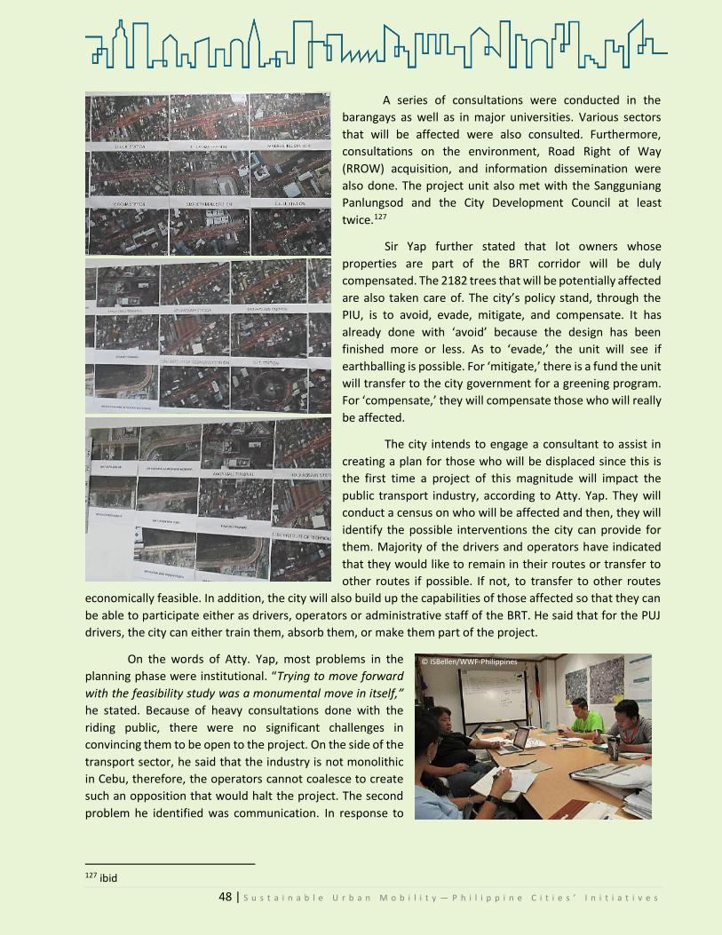
48 | S u s t a i n a b l e U r b a n M o b i l i t y — P h i l i p p i n e C i t i e s ’ I n i t i a t i v e s
A series of consultations were conducted in the
barangays as well as in major universities. Various sectors
that will be affected were also consulted. Furthermore,
consultations on the environment, Road Right of Way
(RROW) acquisition, and information dissemination were
also done. The project unit also met with the Sangguniang
Panlungsod and the City Development Council at least
twice.127
Sir Yap further stated that lot owners whose
properties are part of the BRT corridor will be duly
compensated. The 2182 trees that will be potentially affected
are also taken care of. The city’s policy stand, through the
PIU, is to avoid, evade, mitigate, and compensate. It has
already done with ‘avoid’ because the design has been
finished more or less. As to ‘evade,’ the unit will see if
earthballing is possible. For ‘mitigate,’ there is a fund the unit
will transfer to the city government for a greening program.
For ‘compensate,’ they will compensate those who will really
be affected.
The city intends to engage a consultant to assist in
creating a plan for those who will be displaced since this is
the first time a project of this magnitude will impact the
public transport industry, according to Atty. Yap. They will
conduct a census on who will be affected and then, they will
identify the possible interventions the city can provide for
them. Majority of the drivers and operators have indicated
that they would like to remain in their routes or transfer to
other routes if possible. If not, to transfer to other routes
economically feasible. In addition, the city will also build up the capabilities of those affected so that they can
be able to participate either as drivers, operators or administrative staff of the BRT. He said that for the PUJ
drivers, the city can either train them, absorb them, or make them part of the project.
On the words of Atty. Yap, most problems in the
planning phase were institutional. “Trying to move forward
with the feasibility study was a monumental move in itself,”
he stated. Because of heavy consultations done with the
riding public, there were no significant challenges in
convincing them to be open to the project. On the side of the
transport sector, he said that the industry is not monolithic
in Cebu, therefore, the operators cannot coalesce to create
such an opposition that would halt the project. The second
problem he identified was communication. In response to
127 ibid
© ISBellen/WWF-Philippines

49 | S u s t a i n a b l e U r b a n M o b i l i t y — P h i l i p p i n e C i t i e s ’ I n i t i a t i v e s
this, the city is going to engage a consultant to prepare the communications materials. They envision the
project to be done by the fourth quarter of 2019, or the
first quarter of 2020.
He rated the public’s acceptance of the BRT at
four. For the PUJ drivers and operators, he pegged it at
three because they are on “wait-and-see.” When asked
if the BRT project would be stopped because of the
reported, he said that it was unlikely that the project will
be stopped because the entanglements that need to be
untied are so complicated already. He was referring to
the existing memoranda of agreements. These will also
have implications on the cancellation or deferment.
In addition to the BRT project, Atty. Yap relayed that the city, at the time of the interview, was in
possession of the DOST Hybrid Electric Train (HERT). There was already an agreement to run it, but there is a
disagreement as to the length. This is the same HERT which will be transferred and operated in General Santos
City, as shall be discussed in the following sections.
Hon. Tomas Osmena, City Mayor
Mayor Tommy Osmena first saw the BRT in 1992
in the City of Curitiba, Brazil. He described it as a “very
innovative experiment using high capacity buses
pretending they are trains.” Prior to that visit, he read
about it in Time Magazine and in Reader’s Digest. In
1997, they went to Curitiba to see first-hand how the BRT
works. Since it was “hard to deal with Imperial Manila,”
he completely gave up on the idea until in 2008, he met
two American consultants from the ADB. They
mentioned a mass transit system that would work in the
Philippines.
What Mayor Osmena did was ask the ADB to
give them a grant for a pre-feasibility study, with the
Curitiba BRT in mind. They sent two other letters to the
World Bank and JICA asking for the same. All three
requests were approved. However, then President
Benigno S. Aquino III disapproved the project.
It was only during this returning term of Mayor
Osmena that works for the implementation of the BRT
Project began again. When asked why it took eight long
years before the project could be implemented, he said
that the approval process was very long. There was a lot of negotiation, and he did not want to experiment
with a PhP 10 billion project.
“That’s my basic philosophy. The poor people
come first. The majority comes first. The rich
people—they can leave early they can come
late, they have their own cars anyway. Why
don’t you wait until the traffic dies down then
maybe when we open it up you can have a
shared existence with the BRT?”
Mayor Osmena on his traffic policy philosophy
“It is not BRT versus LRT but public
transportation versus private. What does the
city value more?
It is a question of maximizing the existing road
capacity vis-à-vis the demand being requested
of it. The cause of traffic is not the BRT but the
number of private cars.”
Atty. Rafael Yap, PIU-BRT
Interview with Cebu City Mayor Tomas Osmena wherein he
clarifies the project specifics of the BRT | 2017.08.25
© ISBellen/WWF-Philippines

50 | S u s t a i n a b l e U r b a n M o b i l i t y — P h i l i p p i n e C i t i e s ’ I n i t i a t i v e s
Despite the unhappiness the project can produce if
implemented, he is still pushing for it because he wants to
change the status quo. According to him, the country’s
national policy views public utility vehicles as second-class
citizens. Private vehicles are first class citizens. In the BRT
community, it is the other way around. Private cars are second-
class. BRT comes first. Hence, there is an equalization of the
scales in society.
The BRT is going to affect many people once it is implemented in full blast. To mitigate the negative
effects, the city government has prepared a plan, especially for jeepney drivers whose routes will be affected.
This includes making downtown Cebu closed to private cars, so that only jepeneys can ply routes. In effect,
private car owners would be forced to commute using the BRT.
The BRT in Cebu is patterned after the Curitiba City BRT. Of all BRTs in the world, the mayor firmly
believed that the Curitiba is the best model to follow because it incorporates urban planning. When asked
how, he responded,
“In 1997, the BRT was already 12 years running.
They perfected it already. In Curitiba, you can
change rides without adding anything. No
additional fare. […] Now, in Cebu, the situation is
people have to rent bed space just to go to work.
With the BRT they will not need this.”
He said that it is the BRT model that helps urban design and equalizes social conditions—one can live
in a farther place where house and lot is cheaper, but still can work because the BRT will equalize it.
We asked if the BRT has gained or is gaining support from the public. As mayor, he gauged the public’s
acceptance at three. He acknowledges that the adjustment is
heavy, but believes that when the people see how it works, the
BRT project will be demand-driven. He also recognizes that
people are scared of losing their jobs. However, he believes that
they will eventually adjust to the changes since the local
government will assist them in the transition.
Given the introduction to the BRT by Mayor Osmena
and as Atty. Yap emphasized, the BRT would not have been
pursued were it not for the city’s efforts. And true enough, it
would not have proceeded had they not made steps on their
part to push for funding and support for the project.
Mayor Osmena explicates the plans of his administration for those who will be displaced by the BRT project, as well as the
actions already taken as part of its implementation.
“I have this problem as a city mayor.
Everybody wants to work in the city. And
they project that in a few years 80
percent of the world population will be in
cities. The BRT will not reverse that, but it
will slow it down.”
Mayor Osmena on cities
“We are going to make a lot of
people unhappy. That’s for sure—
because it’s a change. A lot of
people do not like change.”
Cebu City Mayor Tommy Osmena on the apprehensions against the BRT
© ISBellen/WWF-Philippines

51 | S u s t a i n a b l e U r b a n M o b i l i t y — P h i l i p p i n e C i t i e s ’ I n i t i a t i v e s
From this juncture, the explanation of Mr. Villarete is detailed.
Engr. Nigel Paul Villarete, City Adminstrator
City Administrator Nigel Villarete said that
initially, the BRT was for transportation solely. But in
2009, when the city had to look for funding, the BRT
became an environmental project. That time, the
only one willing to fund it was the World Bank
through the Clean Technology Fund. When it was
approved, the reason for funding it was not for
transport, but for emissions reduction.
For the drivers who will be displaced by the
BRT, he said that they never promised that they could
accommodate everybody, but they hope that they
could. He said that in the BRT, there are people
running the buses, running the stations, doing the
repairs. Whoever will be affected will have the first
draft of the jobs. Moreover, since the BRT is positioned in the main road, there is a need to have new routes
leading to the station so new franchises can be created.
The government will do the best that it can to minimize the losses of those whose livelihood would be
negatively affected by the implementation of the project. As to the social acceptability of the BRT, he pegged
the BRT at 7-8 out of 10.
City Administrator, Engr. Villarete go over the particulars of the BRT and other mobility initiatives of the city
“Traffic is a symptom of a deeper problem so if
you’re trying to solve traffic, you are not solving
anything. The sole purpose of the government is
to transport people in the morning to their
workplace so that they can be productive and
produce GDP and in the afternoon when they go
back to their homes. That is the goal of the
government. You do a traffic count of people in
EDSA. You will see that 60 to 70 percent of them
are actually home to work trips.”
City Administrator Nigel Villarete
© ISBellen/WWF-Philippines © KCDDYangotWWF-Philippines

52 | S u s t a i n a b l e U r b a n M o b i l i t y — P h i l i p p i n e C i t i e s ’ I n i t i a t i v e s
Notwithstanding the efforts of the government stated above, not everyone in the government totally
supports the BRT Project. The Association of Barangay Captains (ABC), through their President and ex-officio
City Councilor Philip Zafra, voiced out that they had reservations about the BRT. What follows are the
sentiments of the ABC gathered during the monthly meeting of the Association Board of Directors in August.
Hon. Philip Zafra, ABC President, ex-officio councilor
Speaking for and in behalf of the Association of Barangay Captains,
Councilor Zafra stated for the record that they are not opposing the BRT
implementation, but they signify their reservations, to wit:
1. The BRT will be implemented without first widening the roads.
Accordingly, the widening will take place only in areas where
the stations of the BRT will be placed. The roads should first be
widened before implementation. If the BRT will be
implemented, there should be a dedicated lane for it. What will
remain are just two lanes. All other vehicles, jeepneys, private vehicles, trucks, any kind of
transport will just be utilizing the two lanes left for them. It will just worsen the traffic condition
of city streets.
2. The needs before (referring to the time the BRT was conceptualized 15-20 years ago) are no longer
the same today. Needs now are worse. There are many cars already.
3. The BRT will be utilizing the city’s innermost portion of roads as a dedicated lane for BRT. Will
flyovers be off-limits to any other kinds of vehicles?
4. All agencies in the government including nation, the main problem is RROW acquisition. There is
still that old project that would supposedly widen the south area. It was implemented only up to
a certain part of the road. How can there be an unhampered travel of the BRT if the road is not
yet finished?
5. Did they take into consideration the many intersections along the road when they were planning
the flow of trips? What about those vehicles that will cross the road of the BRT?
He articulated that they wanted more transparency. According to him, some details in the project
were not divulged to them. He even gave Indonesia as an example, where the BRT failed because the streets
were narrow. He compared it to Cebu, which has similarly-sized streets.
The ABC Board, after discoursing on their reservations about the BRT
during their board meeting last August 25, 2017
ABC President, Philip Zafra sharing
his sentiments on BRT Project © ISBellen/WWF-Philippines
© ISBellen/WWF-Philippines
“Now that there is no
BRT, the traffic is
already bad. How much
more if they dedicate
more lanes to the BRT?”
ABC President Philip Zafra

53 | S u s t a i n a b l e U r b a n M o b i l i t y — P h i l i p p i n e C i t i e s ’ I n i t i a t i v e s
Coun. Zafra also lamented that barangays, who are the grassroots, were not considered as partners
in development. He asks that they be taken seriously and be included in discussions, not only during election
period. Nonetheless, he reiterated that if their reservations be answered, they will give their full support to
the project.
Additionally, there are other people outside the government who have reservations with regard to
the project. Representing the business sector, we sat down with Mr. Valeriano Avila, former traffic czar of
Cebu City. He has had a long experience managing the traffic in Cebu as well as in the management of the
Mactan Airport. He also runs their family business in the city. So as a former part of the government and now
part of the business sector, his views shed light
Business Sector
Mr. Valeriano Avila, Business Owner, former Traffic Czar and publicist
Mr. Avila took part in the conceptualization of the BRT in 1997. He opines that the reason Cebu is
getting a BRT now is because it was not given the budget for a LRT, adding that if reduction of emissions is the
goal of having the BRT, then the LRT would be a better option since emissions are not concentrated in Cebu
City alone, but are also produced in nearby municipalities and cities. Personally, he prefers a tram. And
while not the most needed mode of transport, the BRT is the cheaper option, between the BRT and LRT.
When asked about the social acceptability, he could not give a definite quantification since he
perceives that the project has been politicized. Thus, as an alternative, he proposed a tram. It requires the
construction of trails on the road, without damaging the flow. When the tram passes by, the car can wait first
and then can pass through once the tram goes. But, in the BRT, that cannot happen. In the LRT, you need to
construct hug infrastructure first. Another
solution he also proposes is for the DOTr to make
side-loading jeepneys, with ramps strategically
positioned all over the city.
He is firm in his view that cities cannot
afford the BRT. Even if the goal is to reduce
emissions, if the buses will use diesel, there will
still be an emissions problem. With that, he
ended by saying that the BRT is not the optimal
alternative to the traffic problem of Cebu City.
The interviews with representatives from the local government and the business sector must be
juxtaposed with the public’s opinion. While the interviewees are not representative of the entire Cebuano
population, they at least give an idea about the public’s perception of the BRT Project.
Mr. Valeriano Avila
expresses is views on the
proposed BRT project
© KCDDYangot/WWF-Philippines

54 | S u s t a i n a b l e U r b a n M o b i l i t y — P h i l i p p i n e C i t i e s ’ I n i t i a t i v e s
Riding Public and Affected Drivers/Operators
As discussed in the initial part of this section, a number
of the affected members of society were also interviewed.
Summarized below are their responses to the questions on social
acceptability.
The respondents are affected drivers and residents. The
conduct of random interviews with these respondents resulted
to four uniform opinions:
1. As for the taxi and jeepney drivers, the BRT will not alleviate traffic, but will worsen it. It is
also seen as a threat to their livelihood, especially to jeepney drivers. Many of them do not
have contingency plans yet for when they will be displaced.
2. Drivers and residents were not included in the consultation process. Most of them are
unsure of the project’s status.
3. Drivers and residents who will be displaced oppose the BRT Project. They see private cars as
the problem, and the BRT cannot help solve it.
4. The roads of Cebu City are narrow. They cannot expand to accommodate the BRT. One taxi driver said, “If it will be pursued, the traffic will be like in Manila.” Another said since the BRT
route will overlap with some jeepney routes, the jeeps will be removed. He additionally said that it is unfair because it is not the jeeps who cause traffic, but the private cars.
A jeepney driver, who has a wife and child and who transferred to Cebu from Bohol to earn a living, described his daily earnings: When he was asked about the BRT, he said that if it were up to them, it should not be implemented. It is not going to solve traffic anyway, he underlined. One more jeep driver said that if the BRT is from terminal to terminal, what will happen to those passengers from places not passed through by the BRT? A different driver said that there will no longer be a 7-peso minimum fare once the BRT starts to operate.
One more jeepney driver also said that it was impossible
for the government to look for a job for all of them since they still
have to apply. But another driver saw a good thing in their
misfortune, “the good thing is the BRT would not be able to enter
the inner streets of barangays.”
http://newsinfo.inquirer.net
“We earn PhP 2000 [in a day]. The rent is PhP 700. The gas is PhP 700. What is left? That PhP 600 is left to us per day. If the BRT will hire us, how much? Minimum wage? What about those older drivers, how will they be hired?”
Interview with jeepney drivers last
August 25, 2017
© ISBellen/WWF-Philippines
© ISBellen/WWF-Philippines

55 | S u s t a i n a b l e U r b a n M o b i l i t y — P h i l i p p i n e C i t i e s ’ I n i t i a t i v e s
Vendors along Mambaling, another road included in the BRT route, said that the government told them they would be paid in exchange of vacating their lots. Unfortunately, they have no relocation sites. They were called for a seminar about the project and they have already appealed their situations but as of the interview, received no decision yet. Employees of one of the shops along the road were also interviewed. One of them said that the city told their employers to list the names of the workers and that they [the city] would be in charge of looking for jobs for them.
There were four residents along Natalio Bacalso Avenue (where the BRT will begin) who surprisingly
said they were not aware of the project. Another three residents whose settlements are affected by the Road Right of Way (RROW) acquisition bemoaned that even if they were told that they would be paid, they do not know how much and when the next talks would be. They see that it would be very difficult for them to look for a relocation site when asked to vacate. One of them said, “Unless they will pay us millions, then it is okay. But we don’t even know how much we will be paid.”
A resident who lives in the inner areas along the BRT
roads also opined that if the government says it is a go, there is
nothing they can do anyway but to comply. A taxi driver who has
been on his job for over 10 years, said that it is not the BRT that
affects them, but it is Grab that affects their livelihood. Come
nighttime, passengers take Grab. The regular taxi drivers get
passengers last. The same driver asked who will fix the BRT if it
gets destroyed. He said jeepneys only cause traffic if they make
roads their parking areas, but otherwise, traffic is moving.
When the respondents were asked about what solutions they could suggest to decongest the city, these were their responses:
1. The subway would reduce congestion, but it would be better if it were a skyway.
2. Between LRT and BRT, it is the LRT that would reduce traffic and not the BRT.
3. The skyway would surely reduce traffic. There is a flyover and a subway, but they cover just short distances.
4. It is the subway or overpass that can solve traffic. Between the two, it is faster to make an overpass.
It is needed especially along intersections.
5. Outside the city center, it is the overpass that can help decongest.
6. A number coding scheme should be implemented.
7. Pick up points should be assigned in schools to avoid clogging during dismissal time. A lot of [private]
cars make the roads along schools their parking lots.
8. In intersections, when the traffic light turns red, there should be no other cars in the middle. They should be strict.
9. The government should hire more traffic enforcers of CITOM.
© ISBellen/WWF-Philippines
© ISBellen/WWF-Philippines

56 | S u s t a i n a b l e U r b a n M o b i l i t y — P h i l i p p i n e C i t i e s ’ I n i t i a t i v e s
As of September 2017, the BRT is totally a go. The additional budget requested for the acquisition of
the RROW was recently approved by the national government. There is also another proposal to have a BRT
in Metro Manila, but this is still under way. At the moment, it is the City of Cebu that has all the approved
paperwork and is just awaiting implementation.
It is of no doubt that the entrance of the BRT is intertwined with far-reaching change. It is apparent
from the interviews with the people affected that they are not yet completely ready for it. The number one
source of the apprehension among drivers is their impending job displacement and/or dislocation. Among
commuters, the question is whether or not the BRT will alleviate the traffic situation of the city. They have
misgivings as to the success of the project. On the other hand, the local government, particularly the executive,
firmly believes that the BRT is the answer to Cebu City’s transportation plight. Like any change, the BRT is
expected to meet more reactions. Its success, in the long run, is dependent on the people’s acceptance—if its
benefits will outweigh its drawbacks.
5.3.2 GENERAL SANTOS CITY—Hybrid Electric Road Train (HERT) STATUS: Pending
eneral Santos City (Gensan) is located south of the
Philippines in the island of Mindanao. It was also
baptized the Tuna Capital of the country. It has a
total population of 594, 446128.
The slogan of the city is well enunciated in its
2030 vision: GREEN to Creating a Livable Environment for
All towards Nation-building in Gensan (CLEAN). GREEN
stands for: Good governance with integrity and inclusiveness, Revenue growth through PPP, Environmental
security and rehabilitation through disaster risk mitigation and resiliency and climate change adaptation,
Needy and vulnerable population that should be nurtured, protected, developed, and empowered towards
productivity and progress.129 In keeping with this vision, the local government has made moves towards
sustainable transportation.
The LGU will formally receive the Department of Science
and Technology (DOST)’s 40-meter train-like bus “Hybrid Electric
Road Train (HERT)” this September 2017.130
In 2015, the Department launched the HERT. It has been in
Cebu City since February 2017 for a prior-scheduled test run earlier
this year. Because of changing circumstances, the commercial test
run of the HERT is going to be conducted in Gensan. The street
128 Census of Population. (2015). "Region XII (Soccsksargen)". Total Population by Province, City, Municipality and Barangay. PSA. 129 GenSan. (2014). Generali Santos City Economic Profile—Vision 2030. Accessed at: https://gsantoscity.files.wordpress.com/2014/07/gensan-economic-profile-page-006.jpg 130 Mindanews. (2017). ‘DOST’s hybrid train coming to GenSan in September.’ In Mindanews. Published 26 July 2017. Accessed at: http://www.mindanews.com/top-stories/2017/07/dosts-hybrid-train-coming-to-gensan-in-september/
G General Santos City was given the Road Home
Award (for public infrastructure and public
housing projects) during Manila Times
Philippine Model Cities Forum and Awards.
© South Cotabato News
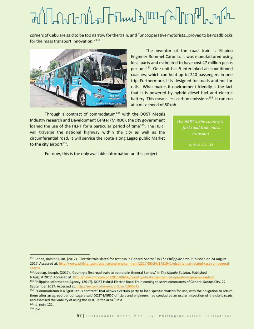
57 | S u s t a i n a b l e U r b a n M o b i l i t y — P h i l i p p i n e C i t i e s ’ I n i t i a t i v e s
corners of Cebu are said to be too narrow for the train, and “uncooperative motorists…proved to be roadblocks
for the mass transport innovation.”131
The inventor of the road train is Filipino
Engineer Rommel Caronia. It was manufactured using
local parts and estimated to have cost 47 million pesos
per unit132. One unit has 5 interlinked air-conditioned
coaches, which can hold up to 240 passengers in one
trip. Furthermore, it is designed for roads and not for
rails. What makes it environment-friendly is the fact
that it is powered by hybrid diesel fuel and electric
battery. This means less carbon emissions133. It can run
at a max speed of 50kph.
Through a contract of commodatum134 with the DOST Metals
Industry research and Development Center (MIRDC), the city government
loaned the use of the HERT for a particular period of time135. The HERT
will traverse the national highway within the city as well as the
circumferential road. It will service the route along Lagao public Market
to the city airport136.
For now, this is the only available information on this project.
131 Ronda, Rainier Allan. (2017). ‘Electric train slated for test run in General Santos.’ In The Philippine Star. Published on 24 August 2017. Accessed at: http://www.philstar.com/science-and-environment/2017/08/24/1731941/electric-train-slated-test-run-general-santos 132 Jubelag, Joseph. (2017). ‘Country’s first road train to operate in General Santos.’ In The Manila Bulletin. Published 6 August 2017. Accessed at: http://news.mb.com.ph/2017/08/06/countrys-first-road-train-to-operate-in-general-santos/ 133 Philippine Information Agency. (2017). DOST Hybrid Electric Road Train coming to serve commuters of General Santos City. 22 September 2017. Accessed at: http://pia.gov.ph/news/articles/1000375 134 “Commodatum is a “gratuitous contract” that allows a certain party to loan specific chattels for use, with the obligation to return them after an agreed period. Lagare said DOST-MIRDC officials and engineers had conducted an ocular inspection of the city’s roads and assessed the viability of using the HERT in the area.” ibid 135 Id, note 121. 136 Ibid
The HERT is the country’s
first road train mass
transport.
Id, Notes 117, 118
© Manila Bulletin Online

58 | S u s t a i n a b l e U r b a n M o b i l i t y — P h i l i p p i n e C i t i e s ’ I n i t i a t i v e s
5.3.3 MUNTINLUPA CITY—Electronic Jeepney Ride for Free (e-JRF) Program STATUS: Ongoing
untinlupa City is located in the South of Metro
Manila. It houses both the New Bilibid Prison
and the exclusive village of the Ayala Alabang
Homes. Branded as the Emerald City, the local
government envisions the city “…as one of the leading
investment hubs in the country, with educated, healthy
and God-loving people living peacefully and securely in a
climate change-adaptive and disaster-resilient
community, under the rule of transparent, caring and
accountable leadership137.”
Additionally, among the city’s mission objectives is
“to promote a broad-based economic growth and business-
friendly environment for sustainable development.138” In
line with this, the city, in partnership with the Lingkod
Muntinlupa Foundation, launched the Muntinlupa
CareCard—an access card for residents.
One of the key components of the MCC is the free
use of cardholders of the jeep for mass transport. In fact the
e-JRF is an adjunct program of the Muntinlupa CareCard
(MCC) Program.
The MCC Program is a product of a Public-Private
Partnership (PPP) between the city government and the Lingkod Muntinlupa Foundation (LMF). With a total
of 34 e-Jeepney units in operation and 6 on the way139, the e-Jeepney Ride for Free (e-JRF) of Muntinlupa was
lauded for its efforts in promoting alternative energy. Of the 34 units in operation, 14 are owned and operated
by the city for free, while the remaining 20 are owned and operated by the foundation for pay.
Aside from the training of the human resource who will operate the units, the city also invested heavily
in infrastructural support, to wit: sign boards, stops, and charging stations. The foundation, on the other hand,
has spent for the purchase, maintenance, and operation of the e-Jeepney units.140
According to the LGU, the green and intelligent
technology is applied in their approach to public
transportation. In fact, the e-Jeep runs on deep cycle
lead acid batteries and utilizes an electric motor. The
electric motor produces zero smoke emission and zero
noise pollution (ibid).
137 Muntinlupa City Website at: http://www.muntinlupacity.gov.ph/the-city/about-the-city/ 138 Muntinlupa City: http://www.muntinlupacity.gov.ph/the-city/about-the-city/ 139 Muntinlupa City UITP Presentation, file from Ms. Salvador. 140 ibid
M The e-JRF was the only entry of the country
to the 2017 global competition held by the
Union Internationale des Transports Publics
(UITP; English: International Association of
Public Transport) in Montreal, Canada. (PIO)
For leading the e-Jeep revolution in the country,
Muntinlupa was declared the “Electric Jeepney
Capital of the Philippines” in 2016 by the Electric
Vehicle Association of the Philippines (eVAP)
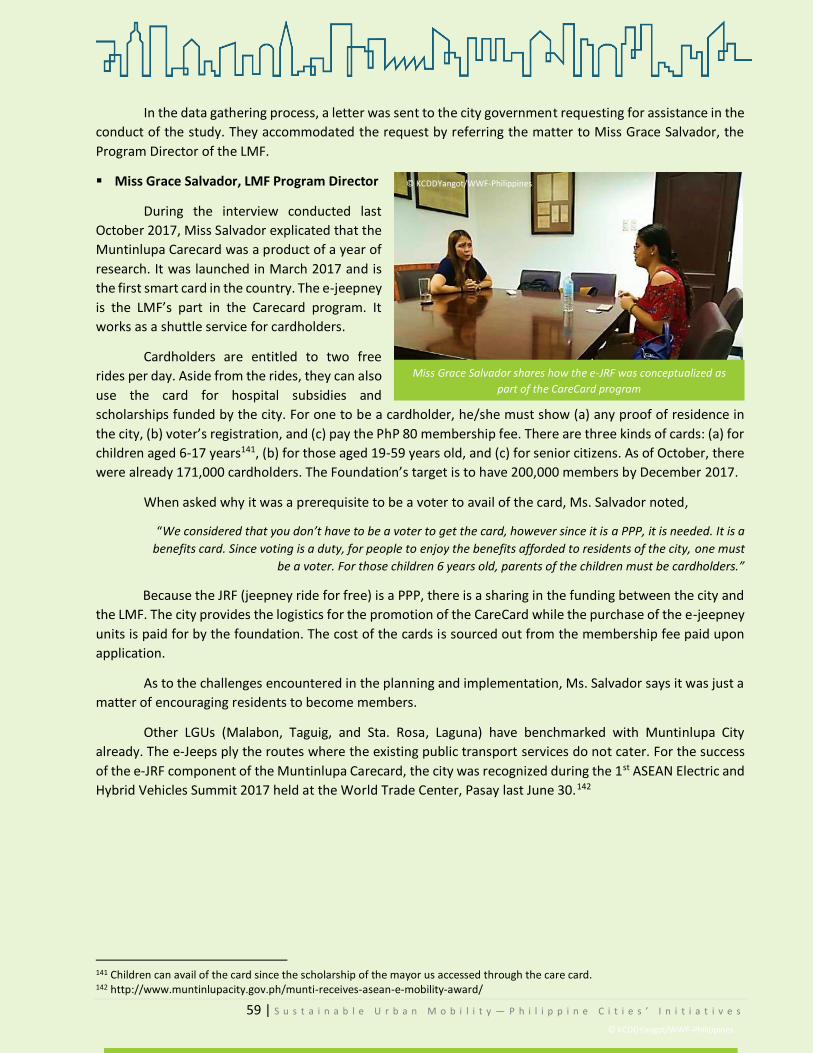
59 | S u s t a i n a b l e U r b a n M o b i l i t y — P h i l i p p i n e C i t i e s ’ I n i t i a t i v e s
In the data gathering process, a letter was sent to the city government requesting for assistance in the
conduct of the study. They accommodated the request by referring the matter to Miss Grace Salvador, the
Program Director of the LMF.
Miss Grace Salvador, LMF Program Director
During the interview conducted last
October 2017, Miss Salvador explicated that the
Muntinlupa Carecard was a product of a year of
research. It was launched in March 2017 and is
the first smart card in the country. The e-jeepney
is the LMF’s part in the Carecard program. It
works as a shuttle service for cardholders.
Cardholders are entitled to two free
rides per day. Aside from the rides, they can also
use the card for hospital subsidies and
scholarships funded by the city. For one to be a cardholder, he/she must show (a) any proof of residence in
the city, (b) voter’s registration, and (c) pay the PhP 80 membership fee. There are three kinds of cards: (a) for
children aged 6-17 years141, (b) for those aged 19-59 years old, and (c) for senior citizens. As of October, there
were already 171,000 cardholders. The Foundation’s target is to have 200,000 members by December 2017.
When asked why it was a prerequisite to be a voter to avail of the card, Ms. Salvador noted,
“We considered that you don’t have to be a voter to get the card, however since it is a PPP, it is needed. It is a
benefits card. Since voting is a duty, for people to enjoy the benefits afforded to residents of the city, one must
be a voter. For those children 6 years old, parents of the children must be cardholders.”
Because the JRF (jeepney ride for free) is a PPP, there is a sharing in the funding between the city and
the LMF. The city provides the logistics for the promotion of the CareCard while the purchase of the e-jeepney
units is paid for by the foundation. The cost of the cards is sourced out from the membership fee paid upon
application.
As to the challenges encountered in the planning and implementation, Ms. Salvador says it was just a
matter of encouraging residents to become members.
Other LGUs (Malabon, Taguig, and Sta. Rosa, Laguna) have benchmarked with Muntinlupa City
already. The e-Jeeps ply the routes where the existing public transport services do not cater. For the success
of the e-JRF component of the Muntinlupa Carecard, the city was recognized during the 1st ASEAN Electric and
Hybrid Vehicles Summit 2017 held at the World Trade Center, Pasay last June 30.142
141 Children can avail of the card since the scholarship of the mayor us accessed through the care card. 142 http://www.muntinlupacity.gov.ph/munti-receives-asean-e-mobility-award/
Miss Grace Salvador shares how the e-JRF was conceptualized as
part of the CareCard program
© KCDDYangot/WWF-Philippines
© KCDDYangot/WWF-Philippines

60 | S u s t a i n a b l e U r b a n M o b i l i t y — P h i l i p p i n e C i t i e s ’ I n i t i a t i v e s
5.3.4 MAKATI CITY—E-Jeepney Project STATUS: Ongoing
ubbed the “Wall Street” of the Philippines, As of the 2015
Census, the city has a total population of 582,602. Makati is
the financial center in the country. In it are located the
Philippine Stock Exchange, the biggest trading institution in the
country.
The city noted in its official profile that it is a “…a major
traffic generator for the greater Metropolitan Manila Area because
it is the primary Central Business District of the country.143”
What does the city then do? It “regulates the in-bound and out-bound traffic during the morning and
afternoon peak hours respectively.”144 Notably, the government has admitted the “great concern that any
further development in the City must be sustainable in terms of its traffic-carrying capacity, or programs are
identified to mitigate potential severe congestion.”145
The remarkable availability of fast data in the city’s portal is a feat. Also found in their portal are traffic
data, which is open access to all. With reference to the city’s traffic volume and demand, the profile
pronounces.
143 1.4. ‘Transportation Network.’ In Profile of Makati City. Vol 1 part 1. Available at: http://www.makati.gov.ph/portal/main/index.jsp?main=2&content=0&menu=0#right_content 144 Ibid 145 Ibid
D © Wikipedia
One of the e-JRF waiting sheds. CareCard holders can avail of up to two free rides per day.
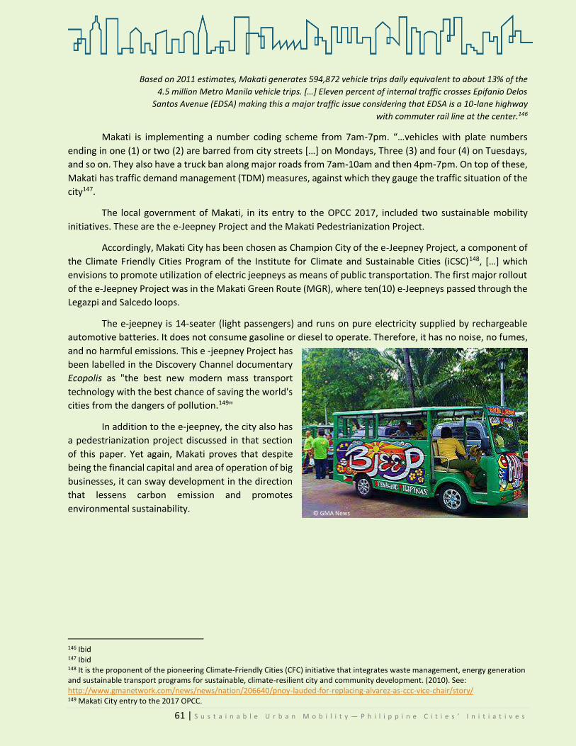
61 | S u s t a i n a b l e U r b a n M o b i l i t y — P h i l i p p i n e C i t i e s ’ I n i t i a t i v e s
Based on 2011 estimates, Makati generates 594,872 vehicle trips daily equivalent to about 13% of the
4.5 million Metro Manila vehicle trips. […] Eleven percent of internal traffic crosses Epifanio Delos
Santos Avenue (EDSA) making this a major traffic issue considering that EDSA is a 10-lane highway
with commuter rail line at the center.146
Makati is implementing a number coding scheme from 7am-7pm. “…vehicles with plate numbers
ending in one (1) or two (2) are barred from city streets […] on Mondays, Three (3) and four (4) on Tuesdays,
and so on. They also have a truck ban along major roads from 7am-10am and then 4pm-7pm. On top of these,
Makati has traffic demand management (TDM) measures, against which they gauge the traffic situation of the
city147.
The local government of Makati, in its entry to the OPCC 2017, included two sustainable mobility
initiatives. These are the e-Jeepney Project and the Makati Pedestrianization Project.
Accordingly, Makati City has been chosen as Champion City of the e-Jeepney Project, a component of
the Climate Friendly Cities Program of the Institute for Climate and Sustainable Cities (iCSC)148, […] which
envisions to promote utilization of electric jeepneys as means of public transportation. The first major rollout
of the e-Jeepney Project was in the Makati Green Route (MGR), where ten(10) e-Jeepneys passed through the
Legazpi and Salcedo loops.
The e-jeepney is 14-seater (light passengers) and runs on pure electricity supplied by rechargeable
automotive batteries. It does not consume gasoline or diesel to operate. Therefore, it has no noise, no fumes,
and no harmful emissions. This e -jeepney Project has
been labelled in the Discovery Channel documentary
Ecopolis as "the best new modern mass transport
technology with the best chance of saving the world's
cities from the dangers of pollution.149"
In addition to the e-jeepney, the city also has
a pedestrianization project discussed in that section
of this paper. Yet again, Makati proves that despite
being the financial capital and area of operation of big
businesses, it can sway development in the direction
that lessens carbon emission and promotes
environmental sustainability.
146 Ibid 147 Ibid 148 It is the proponent of the pioneering Climate-Friendly Cities (CFC) initiative that integrates waste management, energy generation and sustainable transport programs for sustainable, climate-resilient city and community development. (2010). See: http://www.gmanetwork.com/news/news/nation/206640/pnoy-lauded-for-replacing-alvarez-as-ccc-vice-chair/story/ 149 Makati City entry to the 2017 OPCC.
© GMA News

62 | S u s t a i n a b l e U r b a n M o b i l i t y — P h i l i p p i n e C i t i e s ’ I n i t i a t i v e s
5.3.5 MANDALUYONG CITY—E-Trike Pilot Project STATUS: Non-Operational
andaluyong, the Tiger City of the Philippines,
is where the Asian Development Bank and
the Banco de Oro Bank head office were
established. With a land area of 11.06 square kilometers, it is
where part of the Ortigas commercial district is found.
Mandaluyong City was a recipient of a pilot project
funded by the ADB in 2011. Twenty electric tricycles were tested
and operated in the city, each powered by lithium-ion batteries.
Among the findings of the pilot testing were: bigger passenger
capacity, more comfort for both drivers and passengers, it is
noise and smoke-free, and increased daily income150. Each e-
trike could seat around six to eight passengers. One unit costs
about PhP 200,000151.
The ADB e-trike is “a three-wheeled electric vehicle that
is used to ferry a few passengers in short distances in side
streets. Although the current design of the e-Trikes used in
Mandaluyong can carry eight passengers, the Land
Transportation Office only allows tricycles to carry a maximum
of 6 passengers152.” For a full charge, it costs PhP 45 pesos and
it can already operate for 24 hours—way cheaper than gasoline. There were four charging stations established
in the city153. The e-Trike project was seen as a solution to the oil problem—as an alternative to oil fuel.
During fieldwork, residents were approached for
interviews. However, they refused on the basis that there are
no longer government-operated e-trikes plying routes. Thus,
the staff-in-charge of the Tricycle Regulation Office (TRO), Mr.
Cielo Martinez, was interviewed instead. He explained the
situation.
As per our interview with him, it became clear that
while the ADB e-trike project was brought for pilot testing in
Mandaluyong, there are only two remaining trikes of the
original twenty. These two are currently used only as service
of the TRO, since they already have weak batteries. The others
got destroyed permanently since the office did not have the
materials and parts needed to fix them. Even if the ADB provided charging stations, support for maintenance
was lacking. Operations were not sustained154.
150 DOE. Electic Tricycles. https://www.doe.gov.ph/alternative-fuels/electric-tricycles-0 151 Philnews. (2011). ‘Solution to the Oil Problem:Electric-Powered Vehicles.’ In Philnews. Accessed at: https://philnews.ph/2011/04/14/solution-to-the-oil-problem-electric-powered-tricycles/ 152 Engr. Silverio T. Navarro, Jr. (n.d.). E-trike Pilot Project Technical Report. Asian Development Bank. 153 Ibid 154 Martinez, Cielo. (2017). Personal Interview.
M
Inside the e-trike. It could seat at least six passengers,
driver included. Photo by: KCDDYangot,09/18/17
One of the two remaining operational e-trikes in
the city. (Front and side view) Photo by:
KCDDYangot, 09/18/17

63 | S u s t a i n a b l e U r b a n M o b i l i t y — P h i l i p p i n e C i t i e s ’ I n i t i a t i v e s
He also stated that they would have wanted the program to continue because it was good for the
city—less smoke, and less noise. The trikes operated from 2011 to 2015. It was fully funded by the ADB and
the city government was happy to be selected as the recipient. There are e-trikes being operated in
Mandaluyong to this day, but by a private organization, EV Wealth. The units are up for operation on a “hulog-
boundary” system (similar to an amortization). The simple drivers, as Mr. Martinez pointed out could not
afford the EV Wealth trikes155.
The previous e-trike drivers went back to their motor trike driving. They felt equally unhappy about
the program’s discontinuation because firstly, the
operation of e-trikes did not exhaust them as much as
the motor counterparts did. Secondly, the drivers did
not get exposed to heat as much as they were in motor
ones. Thirdly, their incomes were bigger because e-
trikes could seat a maximum of 8 passenger per trip156.
Mr. Martinez was also asked about the public’s
acceptance of the pilot project, to which he replied that
it was well accepted. When the ADB trikes got destroyed,
the EV Wealth trikes took over and while acceptance was
also okay, the cost per trip was more expensive than their
predecessors.
A short interview was also done with Mr. Samon
Digma, the newly-appointed TRU Head. He was one of
the former twenty e-Trike drivers. In fact, one of the two
remaining operational e-Trikes was his. He said, “I was able to send my children to school because of it. [..] I
hope there gets to be another testing [project].”
Even if the project is no longer in operation, it is still worth featuring. It was because of this pilot project
that the country, through the DOE, in due course formulated a nationwide program on e-Trikes. It has
unfortunately been halted because of questions regarding the supplier and the terms of the contract. Now,
many other LGUs have entertained the use of e-trikes within their jurisdictions, as shall be shown later.
155 They cost twice the amount of a motor tricycle. Ibid. 156 Ibid.
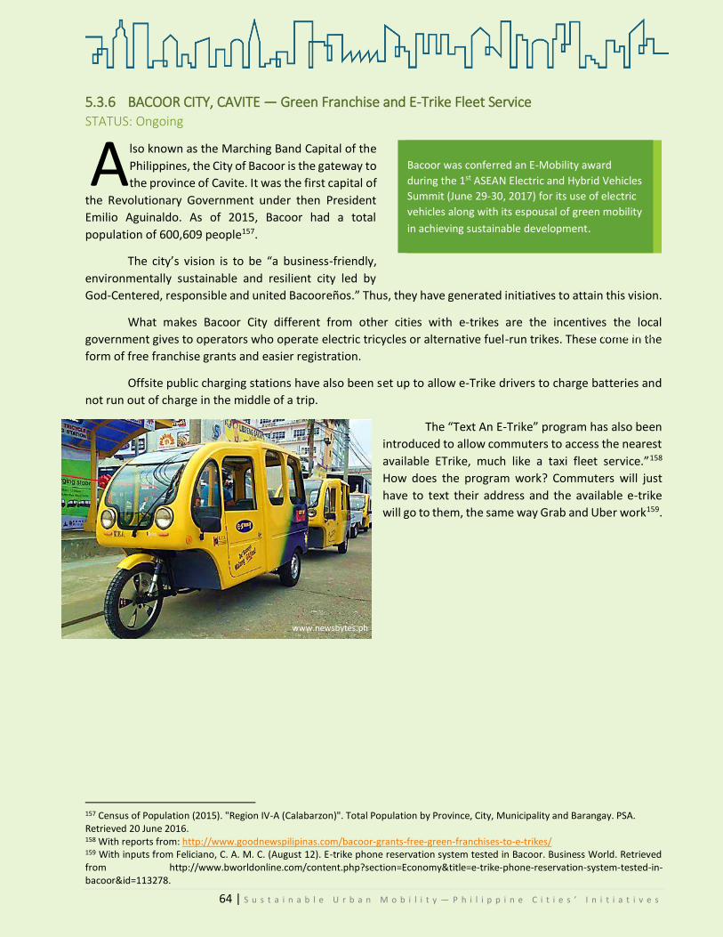
64 | S u s t a i n a b l e U r b a n M o b i l i t y — P h i l i p p i n e C i t i e s ’ I n i t i a t i v e s
5.3.6 BACOOR CITY, CAVITE — Green Franchise and E-Trike Fleet Service STATUS: Ongoing
lso known as the Marching Band Capital of the
Philippines, the City of Bacoor is the gateway to
the province of Cavite. It was the first capital of
the Revolutionary Government under then President
Emilio Aguinaldo. As of 2015, Bacoor had a total
population of 600,609 people157.
The city’s vision is to be “a business-friendly,
environmentally sustainable and resilient city led by
God-Centered, responsible and united Bacooreños.” Thus, they have generated initiatives to attain this vision.
What makes Bacoor City different from other cities with e-trikes are the incentives the local
government gives to operators who operate electric tricycles or alternative fuel-run trikes. These come in the
form of free franchise grants and easier registration.
Offsite public charging stations have also been set up to allow e-Trike drivers to charge batteries and
not run out of charge in the middle of a trip.
The “Text An E-Trike” program has also been
introduced to allow commuters to access the nearest
available ETrike, much like a taxi fleet service.”158
How does the program work? Commuters will just
have to text their address and the available e-trike
will go to them, the same way Grab and Uber work159.
157 Census of Population (2015). "Region IV-A (Calabarzon)". Total Population by Province, City, Municipality and Barangay. PSA. Retrieved 20 June 2016. 158 With reports from: http://www.goodnewspilipinas.com/bacoor-grants-free-green-franchises-to-e-trikes/ 159 With inputs from Feliciano, C. A. M. C. (August 12). E-trike phone reservation system tested in Bacoor. Business World. Retrieved from http://www.bworldonline.com/content.php?section=Economy&title=e-trike-phone-reservation-system-tested-in-bacoor&id=113278.
A Bacoor was conferred an E-Mobility award
during the 1st ASEAN Electric and Hybrid Vehicles
Summit (June 29-30, 2017) for its use of electric
vehicles along with its espousal of green mobility
in achieving sustainable development.
www.newsbytes.ph
www.newsbytes.ph

65 | S u s t a i n a b l e U r b a n M o b i l i t y — P h i l i p p i n e C i t i e s ’ I n i t i a t i v e s
5.3.6 NAGA CITY, Bicol--City Electric Transportation STATUS: Ongoing
aga City, the Heart of Bicol, is an independent
component city of the province of Camarines Sur.
With a total land area of 84.48 sq.m., it houses a
population of 174,931, as of the 2010 census. As an
economic center and the trade city in the Bicol region, it
is the center of Metro Naga (metropolitan precinct of
Bicol). Already a multi-awarded city, Naga was again
recognized as one of the top model cities during the the
Manila Times Philippine Model Cities Forum and Awards
(May 11, 2017). The city bagged the Livelihood and
Employment Haven Award (jobs and programs for self
sufficiency of residents).
In 2011, the city government of Naga passed its
E-trike Ordinance160, allowing the operation of e-trikes in the city. As the law rationalizes, it aims to provide
the community with an alternative means of transport that will promote, inter alia, a less polluted setting and
for drivers and operators to have an opportunity to earn a higher and complementary source of income161.
These e-trikes are also a solution to reduce air and noise pollution in the city.
The minimum fare for each e-trike ride shall be at PhP
8.00 only. Around six to eight people can fit inside162. The E-Trike
Project shall be implemented through a rent-to-own scheme by
the DOE. The LGU states that163:
Interested drivers or operators can avail of the e-Trikes,
provided, however, that they will be paying a monthly
amortization fee for the unit. Technical assistance and capability
building seminars though shall be provided for free by the DOE
with the help of the ADB and the DAP. .
The city was a recipient of 10 e-bikes from the United Nations through its Climate Change Program in
2012164. As of 2017, according to the LGU, there are already 40 e-trikes in operation.
160 City ordinance no. 65, series of 2011.In its explanatory note, the city council makes reference to the ADB-funded e-trikes turned over to Mandaluyong City. The E-tricycle Project is seen as a solution to “ensure energy sufficiency and sustainability.” 161 Naga City Ordinance No. 65 series of 2011. 162 With reports from: http://www.gmanetwork.com/news/scitech/technology/475798/electric-trikes-start-plying-bicol-routes/story/ 2015 Electric trikes start plying Bicol routes 163 Naga City LGU OPCC 2017-2018 checklist 164 Philippine Information Agency: http://archives.pia.gov.ph/?m=7&r=r05&id=72050&y=2012&mo=01
N Like Bacoor, Naga gives incentives to those
who switch to e-trikes. Franchisees shall be
granted (a) fifty (50%) discount on all fees
applicable to tri-mobiles, (franchise fee,
annual supervision fee, mayor’s permit
fee, legal research fee, sticker fee, and
police inspection fee). A business tax
holiday for one year shall also be granted a
proponent for the establishment of the
charging stations required.
©mygreenlivingideas

66 | S u s t a i n a b l e U r b a n M o b i l i t y — P h i l i p p i n e C i t i e s ’ I n i t i a t i v e s
5.3.7 PUERTO PRINCESA CITY—E-trike Pilot Project STATUS: Pending
n 2016, it was reported that the city government of Puerto Princesa and BEMAC Electric Transportation
Philippines, Inc. have inked a Memorandum of Understanding (MOU) “…to establish a pilot operation of
electric tricycle (e-Trike) units within the city.”165 One of the inclusions in the MOU is the provision of
BEMAC of two e-trike units to the city free of charge (model 68VM).
Moreover, technical training for both drivers and operators will be provided by BEMAC. The pilot
project is meant to be a data-gathering mechanism “…to justify the future deployment of more e-trikes.”166
5.3.8 MANILA CITY—E-Trike Project STATUS: Ongoing
While some cities have phased out two-stroke trikes
in favor of four-strokes, the City of Manila is advocating for a
phase-out of gasoline-fueled tricycles in favor of electric ones.
The city government of Manila purchased 280 e-trikes
for its program. According to Manila Mayor Joseph Estrada,
the programs’ beneficiaries will be paying PhP 250 per day to
the city for a duration of four years. This is at zero interest.167
After paying, they can fully own the units as driver-operators.
The e-trikes are manufactured by a Japanese company
with whom the city has tied up. The charging of the batteries of said e-trikes are to be bankrolled by the city.
The batteries are gel-type, which can be fully charged within 4-5 hours168. Meralco, the power distribution
company, constructed a charging station in Binondo. It is the first of the series of charging stations the
company will construct169.
Mainly a livelihood program, the e-trike project is also meant to improve air quality by reducing
pollution. Last April, the LGU turned over 50 e-trikes to beneficiaries in the pilot site of District 3 (Binondo,
Quiapo, Sta. Cruz), Manila.170 They cost around PhP 400,000 per unit. It has a capacity of six passengers. It can
run at a maximum speed of 40-45kph. If successful, e-trikes will also ply routes along Malate and the University
belt area.171
165 Cahiles-Magkila, Bernie. (2016). ‘BEMAC, Puerto Princesa in tie-up for e-Trike project.’ In The Manila Bulletin. Published 21 December 2016. Accessed from: http://business.mb.com.ph/2016/12/21/bemac-puerto-princesa-in-tie-up-for-e-trike-project/ 166 ibid 167 http://www.philstar.com/metro/2017/04/06/1688063/erap-turns-over-50-e-trikes-binondo 168 Ibid 169 Barahan, Ed Margareth. (2017). ‘IEstrada Distributes First 50 Units In Manila E-Trike Program.’ In The Philippine Daily Inquirer. Published on05 April 2017. Accessed at: http://manila.gov.ph/estrada-distributes-first-50-units-in-manila-e-trike-program/ 170 Philippine Information Agency. (2017). http://pia.gov.ph/news/articles/231491479980 171 Ibid
I
www.gmanetwork.com

67 | S u s t a i n a b l e U r b a n M o b i l i t y — P h i l i p p i n e C i t i e s ’ I n i t i a t i v e s
5.4 NON-MOTORIZED TRANSPORT
5.4.1MARIKINA City—Bikeways Program STATUS: Ongoing
arikina is known in the Philippines not only
for being the Shoe Capital, but also for being
the first city with bike lanes (organized). It
has a total population of 531,128. The city is well-
known for being the manufacturer of good quality
shoes, hence, earning the moniker Shoe Capital.
With its vision to be a bike-friendly city,
Marikina has gone far in its realization. Since the 1990s,
the city has embarked on the promotion of a culture of
cycling. In fact, it created the Marikina Bikeways Office,
in charge of managing the program Its vision is to make
Marikina a bicycle-friendly city. Its mission boils down
to three: design and operation of safe bicycle trails and lanes, increase community acceptance of using bikes
and NMT, and demonstrate the benefits of bikes as alternative transport modes and encourage the
“…replication of this pilot program in other parts of Metro Manila.172”
What is now the celebrated Bikeways Program of the city
began as part of a pilot component of the Metro Manila Urban
Transport Integration Project (MMURTRIP) in 2001. It was to be a
“non-motorized and pedestrian path” that will connect residential
areas to centers of commerce, education, hospitals, malls, public
transport terminals, and LRT stations. The project was willfully
endorsed by then Mayor Bayani Fernando, coupled with a request for
funding from the World Bank.173
Even though the program was launched in 2001, as early as
1996, the city promulgated Ordinance No. 137 series of 1996
“identifying streets and avenues to be laid with bicycle lanes for the
exclusive use of cyclists.” The Marikina Bikeways Office was created
by virtue of City Ordinance 117, series of 2001. The MCBO’s main task
is to supervise and manage the maintenance of the bikeways network.
In 2006, the bicycle network was integrated into the city’s transport planning and Traffic Management
Code. Similarly, rules and regulations with regard to the use of NMT were included. The following year, in
2007, the Marikina Bikeways Planning and Design Guidebook was commissioned. Just this 2014, the Bicycling
Code of Marikina city was enacted.
172 Data from the Marikina Bikeways Office (MBO). 173 Ibid
M
© www.turismomismo.com

68 | S u s t a i n a b l e U r b a n M o b i l i t y — P h i l i p p i n e C i t i e s ’ I n i t i a t i v e s
As of June 2015, there are a 7,513 bicycles
being used in the city, with 18 biker
clubs/associations (with more or less 1,343 active
bike users.) Data from December 2015 state that
the bike lanes have by far a total of 82
kilometers174. There are a total of 82 kilometers of
bike lanes (MBO) as of February 2016. 110-unit
bike racks were also installed at schools,
playground, barangay halls, and other public
places.
Bike users are categorized according to purpose of cycling, as follows:175
Work 2079
School 402
Touring 2799
Market 1369
Exercise 1170
Others 193
TOTAL
The City Mayor’s Office referred WWF to Engineer Felipe, who is the head of the MBO. He gave an
insight into the current implementation of the Bikeways program.
Engineer Rommel C. Felipe, Manila Bikeways Officer
The Marikina Bikeways Program is an ongoing
initiative of the city. The city now has three major bike
lanes: creek side, riverside, and safe cycling lanes. The
first two are self-explanatory, while the last pertains to
those lanes within the city. Safe cycling lanes are new
bike routes, which will be introduced in secondary and
tertiary roads that connect to major thoroughfares.
The MBP is fully funded by the city. As to the
problems in the planning and implementation, Engr.
Felipe could not give a definite answer as heading the
Bikeways Offices was given as an additional assignment
to him.
If he were to assess the public’s acceptance of the Program, he did not quantify, but he did say that
their observation says that motorists have adapted to the existence of bike lanes.
During the interview last September, 2017, he also stated that there is a current proposal for a Bike
Law awaiting approval. This is to regulate the e-bikes. Engr. Felipe said that, “some users of e-bikes, they go to
different areas, thinking they are not covered by laws. They go without licenses, helmets. The city must have
174 Ibid 175 Source: Marikina Bikeways Office
The Marikina Bikeways Program is the first
of its kind. The City is also the first in the
country to establish organized bike lanes.
Signage are also installed along the
bike lanes in Marikina.
Engr. RC Felipe expounds on the new bike lanes to be
constructed.
© KCDDYangot/WWF-Philippines
© KCDDYangot/WWF-Philippines

69 | S u s t a i n a b l e U r b a n M o b i l i t y — P h i l i p p i n e C i t i e s ’ I n i t i a t i v e s
a law separating e bikes, motor bikes.” He added that as his
special assignment, they have a collaboration with Meralco.
Accordingly, they will establish an e-bike electric station.
The MBO conducted its own survey among their
residents in 2016. These are the perceived pros and cons of
the Bikeways Program:
Pros Cons
Tipid sa pamasahe/ you need not spend money for transport
Laws/ policies on bike lanes not being implemented
Safety for cyclists and other road users (promote attention and awareness)
Environment-friendly (non-pollutive/no carbon footprint) Local settings have narrow roads
Accessibility/mobility (bike-to-market)
Good road sharing program/space sharing
Lesser/avoid vehicular traffic/congestions No need for bike lanes, bike lanes were only used as parking areas Health benefits
Source: MBO—copied verbatim
“We are now developing creek side bike
lanes, riverside bike lanes, and safe
cycling lanes which will replace the
existing bike lanes.”
Engineer Rommel C. Felipe, Marikina Bikeways Office
Bike lanes in the city leading to the market, schools, and other establishments.
© KCDDYangot/WWF-Philippines © KCDDYangot/WWF-Philippines

70 | S u s t a i n a b l e U r b a n M o b i l i t y — P h i l i p p i n e C i t i e s ’ I n i t i a t i v e s
Enumerated below are the other bike-related projects, activities, and programs promoted and
implemented by the MBO176:
Projects
1. Introduction of New Protected
Bike Lanes
2. Construction of Community
Bike Park and Bike Station
3. Installation of Bike Signs and
Furniture
4. Repair and Maintenance of
Existing Bike Lanes
Programs
1. Annual Bike Clinic
2. Free Bike Repair
3. Bike Safety and
Maintenance Seminar
4. Bike Patrolling
5. Clearing and Cleaning of
Bikeways
Events (Annual and Special
Events)
1. 60+ Earth Hour Fun Ride
(Bikes, March)
2. Rotaride: Padyak para sa
Kalikasan (May)
3. Pedal for HIV (May)
4. Ride of Silence (May)
5. Kalumpang Bike Fest (June)
6. Bikrisma/City Hood
(Christmas Bike Parade)
7. City Fun Ride (Annual)
The achievement of Marikina in effectively implementing the
Bikeways program has inspired many other LGUs to follow suit. As
seen in this case study, other Philippine LGUs have already made
moves related to the promotion of bike use, drawing inspiration
from the case of Marikina City.
Below are three other bike-related initiatives led by cities
whose other major efforts have been already discussed earlier:
176 Ibid
In 2005, Marikina City Bikeways
Program was awarded as the
Outstanding Programme in Local
Governance of the Top Ten
Outstanding Local Government
Programs by the Galing Pook
Foundation for its best practice in
promoting environmentally
sustainable transport.

71 | S u s t a i n a b l e U r b a n M o b i l i t y — P h i l i p p i n e C i t i e s ’ I n i t i a t i v e s
5.4.2 PASIG CITY—Bike Programs Status: Ongoing
Aside from their ongoing implementation of Carless
Sunday, the City is also an implementer of bike lanes and bike
racks installation for each building. According to Ms. Naciongayo,
their program is almost patterned after Marikina, being the most
successful biking program. Pasig started in 2013.
A total of 15 kilometers of bike lanes were installed, in
addition to the 660 bike parking facilities in buildings and other
establishments.
Since 2011, special and monthly bike events were
implemented in the city in pursuit of promoting a healthy lifestyle
and NMT to the Pasiguenos. Now, they have 100 bikes for bike
sharing. They also have a regular Bike for Life program, led by the
city mayor. Bike Patrol groups are also organized. Their main duty
is to secure the bike racks.
5.4.3 NAGA CITY—Bike Festival Status: Ongoing
nother mobility-related initiative177 of Naga is the
yearly Bike Festival, held every November. It is a
whole day event implemented by the CENRO. It
aims to reduce the carbon footprint by promoting zero emission
mode of transportation with the goal of converting Naga City as
Bicycle Friendly City178. Through Executive Order No. 2016-043179,
the City Mayor ordered the constitution of the Naga City Bicycle-
Friendly Task Force (BF Task Force). The task force is in charge of
planning and assessing monthly bike-friendly city initiative as well
as the annual bike festival.
177 In 2008, the city passed ordinance No. 2008-068, designating convenient and safe bicycle and motorcycle parking spaces for registered bikes and motorcycles at the city’s CBD by providing parking facilities such as bike racks and iron hooks. 178 Naga City LGU OPCC 2017-2018 checklist 179 Long title: Institutionalizing initiatives toward bicycle-friendly Naga City by establishing appropriate programs and projects, implementation mechanisms, and funding therefor.
A
Electronic bike racks for sharing in the Pasig
City Hall lobby
www.swimbikerun.ph
©KCCDYangot/WWF-Philippines
Bikers during the 3rd Naga Bike Festival
©www.mnwd.gov.ph

72 | S u s t a i n a b l e U r b a n M o b i l i t y — P h i l i p p i n e C i t i e s ’ I n i t i a t i v e s
5.4.4 CEBU CITY—Bike Lanes Status: Ongoing
Aside from the BRT, Cebu City has also approved its own Tindak Sugbo Ordinance, or the bike lanes
ordinance. The full title is “An Ordinance Providing for Shared Priority Bike Lanes in Designated Roads in Cebu
City, Establishing Appropriate Traffic Rules and Regulations and Providing Funds and Penalties For Violations
Thereof.” It provides for the (1) establishment of shared priority bike lanes/bike friendly zones [Sec.4], (2)
establishment of bike racks/parking facilities [Sec.6]; and the (3) creation of the Tindak Sugbo Board [Sec.9].
The board shall be composed of:
i. the city mayor, or his/her duly designated representative;
ii. the chairperson of the SP Committee on Environment or his/her duly designated
representative;
iii. the head of the City Traffic Operations Management (CITOM) or his/her duly designated
representative;
iv. the head of the City Department of Engineering and Public Works (DEPW) or his/her duly
designated representative;
v. the head of the City Planning and Development Office (CPDO) or his/her duly designated
representative;
vi. five (5) active bike groups; and
vii. one (1) transport organization.
It also penalizes violators [Sec.8]. Likewise, the ordinance states that business permits of commercial
establishments shall not be renewed unless they provide lanes/parking facilities for bikes. The 1.5-meter lanes
will give priority to bikers, although these may be used by motorized vehicles if there are no bikers using the
lane.
The proponent, former Councilor Nida Cabrera, was interviewed. Moreover, City Administrator Nigel
Villarete was also interviewed. He advocates for a different kind of bike lanes from that prescribed in the
ordinance.
CENRO Ma. Nida Cabrera
The CENRO is a policy-making body. It authors the
directions for transportation in coordination with CITOM, but does
not work on implementation. The CITOM has been established first
even before the CENRO was, hence, it takes the lead in
implementing traffic policies.
Ms. Cabrera used to be a city councilor prior to her
appointment as CENRO. She was the proponent of the Tindak Sugbo
Lanes Ordinance (Bike Lanes Ordinance). Despite its approval, it has
yet to be implemented. She explained that this is because the plan
is to integrate it in the BRT project. There are acquisitions of RROW
for the BRT, so there are affected private areas.
She explained that the rationale behind the bike lanes is the reduction of the carbon emissions. The
bike lanes ordinance took almost two years to be approved. The council conducted FGDs, stakeholder
workshops, and spoke with Tindak associations/groups in Cebu. Consultations were also done with other
CEPMO Nida Cabrera, author of the Tindak
Sugbo (Bike Lanes) ordinance Photo by:
KCDDYangot, 08/24/17

73 | S u s t a i n a b l e U r b a n M o b i l i t y — P h i l i p p i n e C i t i e s ’ I n i t i a t i v e s
affected sectors. This includes the transport groups. Upon third reading of the proposal, there were no longer
apprehensions and it was finally approved.
At the moment, she could not gauge the public’s acceptance of the bike lanes since it has not yet been
implemented. She further clarified that the city administrator had some propositions as to the kind of bike
lanes that would be installed. While Ms. Cabrera proposed shared bike lanes (the road is shared between bikes
and cars), Mr. VIllarete proposed off-road bike lanes.
As Ms. Cabrera stated, she was just appointed this mid-year. Nonetheless, she was able to give insight
into the office’s role in relation to the identified initiatives. With regard to the BRT, the CENRO is in charge of
the trees. They will ball out trees affected, except those subject for harvesting. There will be those that will be
cut, but the priority (since the recommendations of environmental groups are stronger) is to ball out native
trees180.
City Administrator Nigel Villarete
As previously stated, what City Administrator Nigel Villarete espouses are off-road protected bike
lanes. He posed his disfavor of painting one portion of the road and designate it as bike lanes. He emphasized
that part of transportation is the safety component. Bike lanes must be physically separated, not just painted.
They should be installed in areas where people can go to places, not the road.
He said that the first challenge is to make the right plans. People look at fads—what sounds good—
and they parrot it and implement it. He gave biking as an illustrative example:
If you are biking to exercise, what emissions have you saved? The government should not spend money
for people to exercise. .. but there are some people who bike to work. When you are biking to exercise,
you are actually causing traffic. When you cause
traffic, you are actually producing emissions. And
don’t advocate that we [the government] should
build bike lanes. For you to exercise? No. bike lanes
are for transportation. When you do that, you shift
from any form of motorized transportation to biking.
Then, you’re saving emissions.
In conclusion, he stated that if the bike lanes
ordinance were to be implemented, they should be
off-road protected bike lanes and not just mere
shared ones. In spite of this contention, the city
should be commended for embracing biking as an
alternative mode of transportation.
180 Cabrera, Susana. (2017). Personal Communication.
“Transportation remains to be the last bastion of
feudalism in our democratic society. It is the car
owners deciding everything. The one that is
causing traffic is the cars. Congestion? Cars. […]
Are there any decision-makers who are not car
owners? The jeepney drivers, do they decide? This
is not just in the Philippines, this is all over the
world that the car owner is making the
decisions.“
Engr. Nigel Paul Villarete, on congestion

74 | S u s t a i n a b l e U r b a n M o b i l i t y — P h i l i p p i n e C i t i e s ’ I n i t i a t i v e s
5.5 INSTITUTIONAL POLICIES
5.5.1 BAGUIO CITY Often mistaken as a part of the
province of Benguet, Baguio is actually a highly
urbanized city independent of Benguet
politically. It is not a component of the
province. It was chartered as a city in 1909,
supposedly to be a hill station for recovering
Americans. It has a total land area of 57.51
square kilometers and a population of
345,366181.
Considered as the “Summer Capital of
the Philippines”, Baguio is no stranger to tourist
influx. Because of the cool breeze, weekends (especially long weekends) have become the peak season.
Previously, peak season was during holidays. It has become a popular term among residents to call the traffic
weekends “Carmaggedon.”
The mission of the city government is to “…create a sustainable and enabling environment that will
promote economic stability and ensure the general well-being of our citizenry.”182 If Pasig has successful
Carless Sundays and Marikina, the Bikeways program, what is there to see in Baguio? Currently, the carless
days and Session Road (the main thoroughfare) pedestrianization are still pending council approval.
Nevertheless, there are laudable institutional policies which have been in effect in the city and which have
greatly helped contain the traffic situation, to wit:
1. City Road Network Planning
a. Resolution No. 106 series of 2016 was passed by the city council,
calling for the creation of a city road network plan tailored to the current
vehicular and pedestrian traffic situation of Baguio.
b. Through Administrative Order No. 49 series of 2016, the city mayor
already appointed members of the Technical Working Group.
2. Pedestrianization of Session Road
a. Proposal for carless days (s.2017) was filed which aims to fully
pedestrianize Session Road, the city’s main thoroughfare, for all days of
the week. Now on 2nd reading for publication, a series of public hearings
shall be conducted to finalize the contents of the ordinance.
b. The only instances when vehicles (police cars, emergency medical
service vehicles, fire trucks, ambulances) shall be allowed in the carless
zone are in cases of emergency or events involving possible threats to
life and limb.
181 Census of Population (2015). "Cordillera Administrative Region (CAR)". Total Population by Province, City, Municipality and Barangay. PSA. Retrieved 20 June 2016. 182 http://www.baguio.gov.ph/about-baguio-city
©IBellen/WWF-Philippines
©IBellen/WWF-Philippines

75 | S u s t a i n a b l e U r b a n M o b i l i t y — P h i l i p p i n e C i t i e s ’ I n i t i a t i v e s
c. In addition to these, it has been a city practice to close Session Rd. for one week (usually
beginning on the Last Monday of February up to the first Sunday of March) during
Panagbenga since 1997. This is called “Session Road in Bloom” (SRB). SRB is one of the
events cited as a substantiation to the success probability of the proposed Carless Days
Ordinance.
3. Central Business District PUJ Ban (Ordinance No. 33 series of 2009) a. It is “unlawful for Public Utility Vehicles to use the Central Business District for loading and
unloading due to heavy traffic and pollution.”
b. Because of this, no jeepney plies routes along the entire stretch of Session Rodd (from
Session Rotunda to Malcolm Square/People’s Park).
4. Total Tricycle Ban Ordinance (Ordinance No. 28 series of 2012)
a. The complete and full title is “An ordinance banning all tricycles within the territorial
boundaries of the City of Baguio.”
b. Baguio is the only PH City that bans the operation of tricycles in all streets and roads. Thus,
the only public means of transport are jeepneys and taxis.
5. Conduct of Night Market a. The entire stretch of one lane of Harrison Road turns into a night market every night from
9pm to 3am. No vehicle is allowed to enter the road between these hours. Not only does it
encourage walking, it also has become a tourist attraction in itself.
©KCDDYangot/WWF-Philippines
Portion of Session Road on a normal business day
©KCDDYangot/WWF-Philippines
Panoramic view of Harrison Rd., the venue of the daily night market

76 | S u s t a i n a b l e U r b a n M o b i l i t y — P h i l i p p i n e C i t i e s ’ I n i t i a t i v e s
6. Motorcycle Ban Ordinance a. For the longest time, motorcycles have not been
allowed to traverse Session Rood and roads
perpendicular/parallel to it such as Harrison Road.,
Abanao Street, Legarda Road, Magsaysay Avenue,
Bonifacio Street, among others.
7. Baguio City/BLISTT (Baguio, La Trinidad, Itogon, Sablan, Tuba, Tublay) Urban Transport
Improvement Project
a. Though the creation of a Metro-Baguio (BLISTT) cluster remains to be contested, the Regional
Development Council (RDC) (the body that authors the development plan of the Cordillera
Administrative Region (CAR) included in its 2011-2016 Regional Development Plan a BLISTT
Improvement Project. Among its goals are to transform crowded sidewalks into walkable areas,
to construct bike lanes, to pedestrianize main access roads, and to look into the prospect of a
BLISTT tramline/cable car system.
8. Automated Guide way Transit (AGT)183
a. Though already endorsed by the RDC of CAR and welcomed by the city government,
funding is still lacking for the final feasibility study on the AGT proposal.
b. The monorail will pass through Baguio City and the Municipality of La Trinidad, Benguet.
Its construction costs about PhP 7 billion pesos.
c. It was met with opposition from members of the public transport sector who believe they
will be dislocated once the proposal pushes through.
Since Baguio is a Tourism City, the local government, in coordination with other regional and national
agencies, has advocated sustainable tourism management. Thus, interviews were done with the City Tourism
Office, the Regional Director of the Department of Tourism-CAR, the City Environment and Parks Management
Officer, and the City Mayor. Business managers/owners who could potentially be affected by the proposals
were also consulted, on top of the commuters.
Local Government
Mayor Morris Domogan was interviewed briefly with regard to the institutional policies and pending
initiatives of the city. His answers were recorded as follows:
Mayor Mauricio G. Domogan
Mayor Mauricio “Morris” Domogan underscored the
city’s inclusion of the aspect of green governance in its agenda,
as manifested in its programs on air and water quality, mobility,
and waste segregation.
He was asked about the pending proposed ordinance on
the pedestrianization of Session Road. He fully supports it, but he
noted that the pedestrianization of Session Road was done in
183 AGT is a fully automated, driverless, grade-separated transit system in which vehicles are automatically guided along a "guideway". (MUCEP, 2015: part 2, p.1-5)
“I am in favor of
pedestrianization. We should
make the city a walking city.”
Mayor Mauricio G. Domogan
“We should replace those jeepneys
that are running coffins. Those jeeps,
at least 15 years, are already old.
What do you expect from [them]?
They are already emitting too much.
They should be phased out[…].”
Mayor Mauricio G. Domogan
MGD

77 | S u s t a i n a b l e U r b a n M o b i l i t y — P h i l i p p i n e C i t i e s ’ I n i t i a t i v e s
1996 during his second term as mayor. This was cut short, unfortunately, by protests from jeepney operators
and drivers as well as taxi drivers. As a result, the city council then relented. Now that the pedestrianization is
being revived, he intends to return it once the alternate roads’ constructions are done. He proposed that it be
first done every weekend since he believes it should not be done drastically.
The mayor also fully supports the AGT-monorail
as it will mean less pollutants. Though he acknowledges
that jeepney and taxi drivers will complain about losing
their livelihood, he wants to see how the city
government can come in and help finance them for the
transition. There are already sources of funding
identified for project implementation, given that the city
does not have sufficient funds for it. Through him, the
city also signed for the reception of the e-jeepney, but
has yet to receive a response.
With regard to public acceptance, Mayor Morris
says that nearly all want to have the e-jeep, but the bone
of contention is the affordability and feasibility of having one in the city. If these are met, he believes that the
mobility projects and programs will surely be accepted by the people.
The matter was referred by the City Mayor’s Office to the City Environment and Parks Management Officer,
Engineer Coleen Lacsamana. Her account includes a rundown of the environmental setting in the city.
CEPMO Cordelia Lacsamana
Ms. Lacsamana enumerated the efforts to
pedestrianize Session Road as well as the carless
day proposal as two of the city’s initiatives on
sustainable mobility. The Environment Code, the
Clean Air Ordinance, the PUJ and motorcycle ban
along Session Road, and the total trike ban in the
city are also among those policies enacted by the
LGU to regulate and manage traffic as well as to
reduce air pollution184. Much as bike enthusiasts
would like to have bike lanes, the same is not
possible because the road system of the city cannot
provide for it, being a “carjack terrain.” The
primordial reason of the city for implementing these legislative measures is mainly safety and next, for
decongestion. Decongestion translates to an automatic reduction of pollutants.
184 There was a study which found that 65% of air pollution in Baguio is from vehicles. From: Lacsamana, Cordelia. (2017). Personal Interview.
Mayor Mauricio G. Domogan details the past and present
environmental programs undertaken by Baguio City.
©ISBellen/WWF-Philippines
“We are a vehicle crazy country. Many times experts
say, we are not planning for people, but for vehicles.
Nobody cares about the implications of really
coming up with mobility plans. They don’t know how
to go about it. We should have a plan. We keep on
doing so many experiments.”
CEPMO Coleen Lacsamana

78 | S u s t a i n a b l e U r b a n M o b i l i t y — P h i l i p p i n e C i t i e s ’ I n i t i a t i v e s
With regard to mobility, Baguio is facing
several issues, according to the CEPM Officer. There is
no regulation on PUVs that are alternatives to big
buses (referring to UV express and other colorum
vans). Another concern is parking in the CBD. She
wants parking, but it must be placed in proper areas.
One more problem is the increasing number of
ancestral claims being lodged on parts of the city’s
parks. These are contributory to the greater problem
of congestion in the city. Now, there is the apparent
unpopularity of pedestrianization.185
Miss Colleen attributed this unpopularity
to the lack of an efficient information
dissemination system. She said, “…nobody is
trying to explain the implications. Who are
apprehensive of the program? It is the business
establishment owners. When they see that more
people are walking, maybe then can change their
mind.” She pointed out the irony that while they
allow Session Road to be closed for one whole
week every year during the Flower Festival
(Panagbenga), they reject the permanent
pedestrianization of the thoroughfare. In her
professional opinion, urban planning is wanting,
sustainability- and environment-wise.
In relation to connectivity, the city also
has green spaces. There is connectivity from one
park to another through the sidewalks. Baguio
has seven major parks, excluding community-
based parks in the respective 128 barangays186.
These also foster an environment of walkability in
the busy urban space of Baguio. In effect, the
stadium of walkability in Baguio is somewhat a
paradox. It is rejected in the center, but approved
of in the periphery. From one park to another,
people utilize these connecting sidewalks, without complaints. But when the focus is shifted to Session Road,
hesitations loom.
Ms. Lacsamana strongly considers that there should be Pilot Demonstration Areas (PDAs), and the city
should be the main PDA of all of its programs. Given this, she gauged the public’s acceptance of the mobility
initiatives at 3. In terms of the initiatives the City is doing, however, she deems that the City is not appreciated.
185 Ibid. 186 Ibid.
Session Road is regularly pedestrianized during special events such
as Baguio Day celebration.
CEPM Officer, Cordelia Lacsama shares the initiatives of
Baguio City
©ISBellen/WWF-Philippines
© KCDDYangot/WWF-Philippines

79 | S u s t a i n a b l e U r b a n M o b i l i t y — P h i l i p p i n e C i t i e s ’ I n i t i a t i v e s
There are a lot of advocacy groups who speak up about sustainability issues, but because of the ostensible
disconnect between them and the City government, these plans do not “cascade to the masses.”
When asked what she would recommend to the City to target these issues, she answered, “We really
need to mainstream more existing policies and regulations in the city. Nobody is consolidating the initiatives
we are making and consolidate[ing] it so we know if we are moving forward or we are stagnant187.” Thus, she
proposes a consolidation in the form of a codification of all transportation and mobility-related policies.
To end, she said that the City has been overtaken by development. Baguio is naturally destined to be
visited by people. “We cannot close Baguio to tourists despite the traffic they bring,” she laments.
187 Ibid.
The whole stretch of Session Road is home to a large volume of vehicles on a normal business day. This photo,
including those that follow, show how the road looks on car-free days.
© KCDDYangot/WWF-Philippines
© KCDDYangot/WWF-Philippines

80 | S u s t a i n a b l e U r b a n M o b i l i t y — P h i l i p p i n e C i t i e s ’ I n i t i a t i v e s
Baguio has 20-30 or more parades per year because the City is very conducive to walking188. As a
vacation destination, the tourist count of Baguio is rising. The CTO said that the evening population is at
300,000. The day population is more. From the peak season being on holidays and during Panagbenga, the
peak season now is on weekends. The City has become the weekend destination. Mr. Joma Rivera details how
tourist influx affects Baguio.
City Tourism Officer Jose Maria Rivera
On top of the total trike ban and the PUJ ban in the CBD, CTO Joma Rivera acknowledged that there
were other initiatives practiced by the City that help reduce emissions. He was referring to the yearly closure
of Session Road for revelry during special events such as the Baguio Day (from 5AM-midnight), the Flower
Festival/ Panagbenga (last Sunday of February to the first Sunday of March), Karkarna ti Rabii (October),
Lantern Parade (December), among others. In an interview last August 2017, he also mentioned the yearly
Photo-Walk Competition, a circuit-based photography contest that promotes walking and environmental
sustainability awareness. Participants go to unexplored
places in the City, with a certain theme in mind. The
rationale behind these is to raise awareness that
walking is a good mode of transport and to encourage
people not take their vehicles to town. These programs
are at no cost to the City (except for the Photo Walk,
which needs funding for the prizes). The Tourism Office
does not spend, but it utilizes the existing logistics it has
even if they have ancillary expenses.189
As with any government office, the CTO faces
challenges of its own with regard to its implementation
of mobility programs. Sir Joma relayed that there is a
lack of resources at their disposal, being a mere office under the City Administrator’s Office. Nevertheless,
188 Rivera, Jose Maria. (2017). Personal Communication. 189 Ibid.
Acting CTO Joma Rivera listens to WWF’s initiatives with
cities
Session Road on a pedestrianized day
© KCDDYangot/WWF-Philippines © KCDDYangot/WWF-Philippines
© KCDDYangot/WWF-Philippines

81 | S u s t a i n a b l e U r b a n M o b i l i t y — P h i l i p p i n e C i t i e s ’ I n i t i a t i v e s
these temporary pedestrianization efforts are well accepted by the people, including business people, in Mr.
Rivera’s professional judgment
He believes that the carless day would become an added attraction to the City because people will be
going to session road to see it. “It is not enough maybe to pedestrianize, but maybe to add another attraction,
to put al fresco restaurants and all, for people to appreciate that there are no cars and that they will be
encouraged to pedestrianize,” he puts forth.190
According to him, as a destination city, Baguio has learned to adjust to the influx of tourists. His
primary recommendation is not to encourage visitors to bring their cars. He said, “for instance, on special
events such as the media congress, we partner our visitors with our local drivers as well as Grab taxi so that
they will be using the existing vehicles we already have in the city.”
From the Local City Tourism office, an interview was also done with Department of Tourism (DOT)
Regional Director Venus Tan on her programs for making Baguio a walkable city.
DOT Regional Director Marie Venus Q. Tan
Dir. Tan started began by recalling the old Baguio. She delivered a narrative of the city’s history.
Baguio was built for R and R (rest and recreation) wellness, being then an American Hill Station.
Regarding the vehicular traffic brought by tourists, Dir. Tan stated, “The equation of having 5000 taxis
in the city is already wrong because the carrying capacity is no longer enough.” She wants people to have a
sense of responsibility to nature. Thus, she launched her RevBloom Program—to re-green and revitalize
Baguio.
She proposed the putting up of signage along TPLEX (Tarlac-Pangasinan-La Union Expressway) that
walking in Baguio City is healthy. Within the city, she intends to erect walking matrix signage, which will tell
people how many calories will be burned by walking certain distances, with corresponding average lengths of
time to get there (for instance, the signage will say 1.6 meters = 130 calories and the time it takes to get there
from that point). What Dir. Tan hopes to achieve is health tourism under her RevBloom Program.
On the matter of the proposed pedestrianization, she, like
the other government officials, support it. She also suggested that
the lane of cars going up must be the one that will be
pedestrianized since driving up requires revving the car. This, in
turn, means more emissions. Like the CEPM Officer, Ms. Tan
believes that if Session Road is successfully closed to vehicles for
one whole week every year, pedestrianization can be done, too, at
least once a month. She believes that it is simply a matter of
rerouting traffic and teaching people to walk.
190 Ibid.
“Urban development is too much
already, but what do we do to avoid
that? We can change mindsets to
make people more responsible to
nature. It is a call to action for people
to realize the importance of the city. “
Dir. Venus Tan

82 | S u s t a i n a b l e U r b a n M o b i l i t y — P h i l i p p i n e C i t i e s ’ I n i t i a t i v e s
During the interview, she talked about the
application DOT filed for and in behalf of the city as
one of the UNESCO Creative Cities. This is also in line
with the RevBloom Program, so that Baguio can now
be positioned as an art city, a resort city, and as a
walking and wellness city.
Just this November, the UNESCO Creative
Cities Network awarded Baguio City as the first
Philippine Creative City for Crafts and Folk Arts,
alongside 63 other Creative cities in the world.
Affected Public (Commuters, Drivers, Business Establishment Owners)
Different members of society were interviewed about the carless day and pedestrianization proposals
as well as the institutional policies implemented by the city.
All respondents agree that traffic is a major problem in the CBD, especially on weekends and holidays.
One common remark is that there are too many cars, but so few parking slots. As a result, those tourists with
cars who are not aware of the 9-4 parking window along roads in the CBD disregard traffic rules and park
illegally. On other topics, there are a multitude of views from those interviewed.
For the business sector, the general view is that the ban on PUJs, trikes, and motorcycles along Session
Road does not harm the businesses. Patrons are mostly students, since major universities are very near Session
Road. As to the pedestrianization and carless day, there is an apparent double-edged take on the proposals.
The proposals, if implemented, can either weaken the businesses or not affect it significantly at all since not
all patrons have cars anyway. There are “undisciplined tourists who come to the city and bring their Manila
attitude.” All these contribute to an unpleasant situation along Session Road.
For commuters, pedestrianization is a good thing. It can help make Baguio a “healthier city.” The same
was said about carless days and the ban on PUJs in Session Road. The idea is that by allowing more vehicles to
enter, heavier traffic and worse pollution can be expected. As to trikes, one respondent said that trikes should
not really be allowed to ply routes in town, as they are “aesthetically” not pleasing.
Another commuter said that carless days would help improve the air quality in Baguio, especially so since one study said that the PM10 content in the city was highest in the CBD191. One more respondent who both commutes and drives opined that “roads are really not just for cars but for people.” He said that the only time he uses his car is when he goes to work. Beyond that, he can just commute or walk from establishment to establishment since the distances are just short and walkable. He favors the pedestrianization and implementation of a carless day because these will help the traffic problem. Notably, he said that, “the driving population should participate in pedestrianization efforts because they would really help bring back the old Baguio.” That way, drivers could be well ordered. His take on the trike and motorcycle ban is that it is good for the city since it reduces both noise and air pollution along Session Road. Another respondent who happens to be a barangay official shares this perspective. She thinks that motorcycles would just worsen the traffic situation if they were allowed to enter Session Road.
191 This was in reference to the study of Dr. Achilles Costales and Dr. Angela Catelo.
DOT Regional Director Marie Venus Q. Tan poses for a
photo after expounding on her project, RevBloom.

83 | S u s t a i n a b l e U r b a n M o b i l i t y — P h i l i p p i n e C i t i e s ’ I n i t i a t i v e s
Of all respondents, it was the Baguio old-timer, senior
citizen, who was the sole person to say that taxis were a great help.
She thinks taxis are better than other public utility vehicles because
it can take you where you want to go, without needing to stand in
long queues before you can ride. This is in relation to her health and
age. For her, pedestrianization is disadvantageous for senior citizens
who have a difficult time walking. She equally dislikes having
motorcycles and tricycles along Session Road because as per her
experience, they are a distraction on roads and can cause accidents.
When asked what solutions they can propose to address the
traffic problem, they had many answers. These are chronicled as
follows:
1. Since the CBD streets are cramped with vendors, the city should designate just one place for them in
the street for their vending.
2. The city should give incentives to establishments who abide by green practices. 3. It should also be stricter when it comes to enforcing the parking laws. Some people park in spaces
designated for building guests, but are not actually guests.
4. Better information campaigns are needed to inform those ignorant of the rules and regulations.
5. The city can partner with the academe so that the proposed solutions related to sustainable
development can be translated to action.
6. There should be a centralized system of registering tourists who come to the city.
7. Business establishments should be required to have parking spaces so that people will not need to
park along streets.
Aside from those conversed with above, the transport sector representative was also interviewed. The
Federation of Jeepney Operators and Drivers Association—Baguio-Benguet-La Union Chairman Jonie Itliong
aired their side. He is also currently working in a transportation management group, Beep. He gave insight into
the plight of the drivers and operators:
Federation of Jeepney Operators and Drivers Associations—Baguio-Benguet-La Union
(FEJODABBLU) Regional President Mr. Perfecto F. Itliong, Jr.
Straight to the point, Mr. Jonie Itliong said that jeepney drivers are against the modernization program
of the national government because of poverty. They cannot afford the down payment for the said vehicles
amounting to PhP 400,000 and PhP 500,000. What the jeepney drivers and operators in Baguio want is an
upgrading, and not modernization. Upgrading means repainting and overhauling the jeepney, changing the
engine to a new one, but the registration stays. With modernization, the registration is automatically a new
one—2017.
Since the main concerns of the transport sector are the institutional policies and proposals on
pedestrianization and carless days, these were the foci of the interview.
© ISBellen/WWF-Philippines

84 | S u s t a i n a b l e U r b a n M o b i l i t y — P h i l i p p i n e C i t i e s ’ I n i t i a t i v e s
On the banning of PUJs in Session Road, Mr.
Itliong wholly approves of it. This is because according
to him, smoke belching is very “lush”; add to that the
fact that different loading areas there have become
parking lots. He was part of previous experimental
traffic schemes by the City. Recalling how they tried to
disallow cars from going up, he observed that even
with all cars just going down, the downtown area gets
clogged. Traffic was just transferred, but downtown, it
gets choked.
He likewise considers carless days good as long
as it will be sustained. He said that if it will be just for
one or two days, it is not significant, but if it can be done every week on a regular basis, that would be better.
As for pedestrianization, he opines that it can be done in places other than Session Road because it will surely
cause traffic and can become a source of dissatisfaction among visitors.
All said, he concluded that both pedestrianization and carless day would not benefit the traffic
situation. According to him, these will clear the center, but will clog the outskirts. By clogging the outskirts,
cars will be on idle mode, thereby producing more emissions and exacerbating pollution. This means more
expenses on crude oil and less income for jeepney drivers.
When asked if he had proposals in mind to help decongest the city especially in terms of mobility, he
gave six alternatives. First, he proposes that since public utility vehicles, including jeepneys, have rest days on
top of their coding schemes, private cars should have, too. Second, on Saturdays and Sundays, an odd-even
scheme for private cars should be implemented. Third, an electric jeep with designated stops can be
introduced. Fourth, an electric tram can also be placed in the CBD. At least if the tram is no longer on the
tracks, cars can pass through. Fifth, a multilevel parking should be constructed to help solve the problem on
illegal parking. This, however, is subject to the condition that there should be no cars parked along Session
Road and other CBD roads. And sixth, the bus terminal in Governor Pack Road corner Upper Session Road
should be cleared and transferred elsewhere to de-clog that area.
The interview ended with these proposed alternative solutions that the city can adopt without
harming the livelihood of jeepney drivers and operators.
Even if Baguio is 250 kilometers away from Manila, urbanization has smitten it as rapidly as it has in
the capital metro. Thus, while some of the initiatives are still pending, they are included here because they
serve as bases for other cities similarly situated, and because they show that Baguio has been exerting effort
in battling with climate change.
There are also initiatives included in this study that are no longer operational. The same logic applies.
They are highlighted here because they can be inspirations for other cities whose social circumstances can
accommodate the initiatives.
FEJODABBLU Regional Chairman PF Itliong voicing out the
concerns of the transport sector with regard to
pedestrianization.
© ISBellen/WWF-Philippines

85 | S u s t a i n a b l e U r b a n M o b i l i t y — P h i l i p p i n e C i t i e s ’ I n i t i a t i v e s
Trajectories and Prospects
The initiatives laid out in this case study are but a few
selected of the many that Philippine cities are engaging into in
their effort to achieve sustainable development. Individually,
these initiatives seem to make but a dent in the movement
towards sustainable development but collectively, it is
indubitable that they have a great impact on saving the
environment. Sustainability has hope in these cities.
6.1 SUMMARY A recurring pattern can be seen in the selected cities’
initiatives—there is the recognition that economic development
demands equally important initiatives to slow down, if not halt
or reverse its negative effects on the environment.
Two dominant motifs emerge as the foci of cities’ efforts on the subject of mobility—walkability and
biking as a mode of transport. These are the ones that are the most common among cities. What is
commendable about this is that there is a remarkable shift from motorized to non-motorized transport in
various localities.
Into the bargain, for metro-city areas, mass transport is also a central concentration. Take for instance
the Cebu and Metro Manila BRTs. This is probably because of the large land areas and distances between and
point-to-point that will be serviced by the mode of transport. Bigger cities mean bigger populations. This is
likewise why while the BRT is seen as a solution to Cebu City traffic, it may not be valued the same way, say,
in San Fernando City.
E-tricycles and e-jeepneys are similarly important alternatives to the usual gas-fueled motor vehicles.
Because they run on electricity, they also reduce noise and air pollution—problems which beset cities these
days. Then, in cities where parks play a fundamental role in the social lives of the populace, they become
instruments of walkability. This is illustrated by the Iloilo esplanade, which has encouraged walking along the
Iloilo River and near a major thoroughfare. The same is true in Baguio City, where, if one would look at the
parks from a bird’s eye view, one would see that all of them are connected by sidewalks, thereby constituting
one network of walkable lush greens. In the face of urbanization, Iloilo and Baguio retain a green character.
There is likewise an emerging pattern concerning the challenges faced by cities in the planning and
implementation of initiatives. The first one is in getting the people’s full support. For those initiatives that
upset employment, drivers and operators voiced out their opposition. For those that imposed sweeping
adjustment, it was the riding public who conveyed their dismay. The second pattern is in information
dissemination. It appears that regardless of the efforts of the local governments to circulate details of the
initiative/s, there still are sectors that remain uninformed. The third one is in going head on with the business
owners. It is a fact that every action has an equal and opposite reaction. For initiatives that affect the
operations of commerce, business owners expressed qualms. Their interests impinge on the smooth
implementation of initiatives.
The following subtopics will
be tackled:
Summary of the initiatives and
findings
Conclusion
Recommendations

86 | S u s t a i n a b l e U r b a n M o b i l i t y — P h i l i p p i n e C i t i e s ’ I n i t i a t i v e s
6.2 ISSUES AND CHALLENGES
With a complete look into the interviews and initiatives of cities, the following issues and challenges can
be drawn out:
1. Inefficiency of public transport—Across cities, what is very professed is that public transport is
inefficient. This is especially the case in Metro Manila where traffic consumes a significant amount of
time of commuters.
2. Apparent disconnect between local government and private sector; and within the government—
There are apparent problems in communication and coordination lines between and among
government departments, and between the government and private/civil society/people’s
organizations. Some may be attributed to difference in political views/affiliation, and some to
misrepresentation (or lack of representation).
3. Lack of financial capacity of local government units—A lot of city officials have expressed that even
if they want to implement sustainable programs, most of these require funding for infrastructure
building or for purchasing. The budgets of cities are not the same. Smaller cities get smaller budgets,
making it impossible for them to, for instance, spend for the construction of a monorail, which costs
millions of pesos. High-impact projects such as LRT or BRT are not constructed pronto because of lack
of funding. Thus, they have to be funded through grants or loans from international agencies.
4. Unintegrated road network and land use plans—For example, instead of making plans, what local
governments do is they paint bike lanes or expand roads to accommodate new cars. This does not
solve the problem. It just transfers traffic and does not target the root cause. As long as transport
networks are not assimilated into land use plans and city development plans, little or no change at all
can be expected. This has been proven true in many case cities.
5. Wide off the mark policies—There are city policies, which are promulgated as knee-jerk reactions and
not really as solutions to the congestion problem. An illustration would be the coding schemes, which
are not always effective. In some instances, they encourage people to buy two cars, for alternate use.
Mayor Osmeña pointed this out, as he explained why Cebu City does not have a coding scheme,
despite immense vehicular activity.
6. More cars make more roads logic—Some LGUs solve the congestion brought about by the increasing
volume of cars by building more roads. This is a “Band Aid” solution that addresses only the immediate
effects of the traffic. Many of these roads are nationally funded, and so they are marred with delays
in construction, which also contributes to added congestion.
7. Reduction of air pollution not a rationale—While there are cities whose rationale is to improve air
quality, in most cities, policies and programs are carried out for traffic reduction. Air pollution is not
the main goal, but merely a byproduct.
8. Lack of comprehensive traffic data192—The reason why no adequate analyses are made on mobility
and transport is because the data are either insufficient or unavailable. These are necessary in terms
192 Save for Makati City.

87 | S u s t a i n a b l e U r b a n M o b i l i t y — P h i l i p p i n e C i t i e s ’ I n i t i a t i v e s
of planning and making projections. This is also essential so that baseline data can be established.
Once this is established, there is a better gauge of whether or not the LGU is moving forward in terms
of sustainable mobility.
9. Unavailability of data for NMTs—This is important, too, in planning so that the office in charge may
include it in the land use and transport plans. Save for the City of Marikina that has cycling data, no
other city has wide-ranging data on cycling activity.
To disentangle these, a sustainable urban mobility plan (SUMP) can be made in each city. This will incorporate
pedestrian and vehicular traffic, garbage segregation, and other aspects of congestion into one plan. Given
said issues, inclusive solutions can be created if all stakeholders are involved in the planning process. A wide-
ranging inference from the data gathered is that Philippine cities want sustainable development, but they have
qualms as to the sources of funding for projects and programs. A SUMP is a relatively inexpensive way of
targeting mobility challenges.
SUSTAINABLE URBAN MOBILITY PLAN
A Sustainable Urban Mobility Plan is a strategic plan that is designed to cater to the mobility needs of
people and businesses in cities and their surroundings for a better quality of life. It builds on the existing
planning practices and takes due consideration of integration, participation, and evaluation principles193.
Roads are administrators of connectivity. In Metro Manila alone, residences are connected to
innumerable establishments and institutions. This is why road connectivity is very essential. A SUMP
recognizes this.
193 Source: Rupprecht Consult, 2014.
Mobility Plan
stakeholders
local government
academe
business sector
organizations
residents and riding
public
national government

88 | S u s t a i n a b l e U r b a n M o b i l i t y — P h i l i p p i n e C i t i e s ’ I n i t i a t i v e s
It is not that public transport is expensive, but it is because it is ineffective and inefficient that most
people prefer private vehicles. Mobility plans must focus on pedestrians and public transport, and not on
private cars. The SUMP should also detail the goals and targets of the local government
What is the scope of a SUMP? The policies and measures defined in a Sustainable Urban Mobility Plan
cover all modes and forms of transport in the entire urban agglomeration, including public and private,
passenger and freight, motorized and non-motorized, moving and parking194.
The Vienna Model can be used as a basis: 195
194 p.11 in ibid, citing PILOT Project. Sustainable Urban Transport Plans –SUTP Manual, Guidance for Stakeholders“ (2007) 195 Vienna SUMP, …Vienna City Administration (2015). Urban Mobility Plan Vienna. Vienna City: Vienna City Administration. p 6 and 7

89 | S u s t a i n a b l e U r b a n M o b i l i t y — P h i l i p p i n e C i t i e s ’ I n i t i a t i v e s
Different modes of transport are taken into consideration. To have a better visualization of how much space
each mode uses, below is an illustration:
196
The difference between the traditional traffic plans and a SUMP are detailed below:
197
196 Ibid, p.11 Rupprecht Consult (2012). The State-Of-The-Art of Sustainable Urban Mobility Plans in Europe. Revised September 2012. Germany: Rupprecht Consult. 197 p.3, GIZ (2014). Urban Mobillity Plans: National Approaches and Local Practice (Sustainable Urban Transport Technical Document #13). Germany: Deutsche Gesellschaft fur Internationale Zusammenarbeit GmbH. 3

90 | S u s t a i n a b l e U r b a n M o b i l i t y — P h i l i p p i n e C i t i e s ’ I n i t i a t i v e s
6.3 RECOMMENDATIONS
It is in this light that, aside from the SUMP as a general recommendation, the following specific ways
forward are also proposed:
1. Cities must re-think their urban plans. Their land-use plans must include mobility networking so that
transport infrastructure and mobility groundwork are taken into account. This will ensure that plans
will be executed to the people’s favor even if the reins of administration in the government will
change. Because transportation networks connect different institutions, it should be properly planned.
Walking, cycling, and mass transport are also modes of transport, but if not integrated in Land Use
Plan, may be rendered useless because of alterations in patterns of land use.
2. Land use plans and other local development plans must be in line with national policies. The plans
of component and highly urbanized cities should take into consideration the provincial and regional
plans to ensure consistency. Coordination at the very least should be conducted in order for plans to
be integrated well.
3. There must be a countrywide collation of mobility programs, activities, and projects (PAPs) by the
national government, similar to a directory. The purpose of this is to have a national reference book
of initiatives that cities, and even municipalities, can adopt. Since the Philippines is an archipelago, it
is not that easy to convey PAPs from one city to another, especially if seas and islands separate them.
4. If cities cannot, then the national government should invest more in improving public transport.
Having many modes of transport is much an advantage as it is a handicap. Too many modes of
transport can mean clogged junctions and populated streets. Too few can mean longer travel times
and more cutting trips. The answer really is public transport that is efficient.
5. Private cars should also be regulated the same way public transport is—in terms of road protocol.
Since private cars already outnumber public ones, they should be subjected to more stringent coding
schemes than those existing now. If PUJs and trikes are banned in many CBDs, private cars may be
banned as well. This can help decongest the urban centers. Mayor Osmeña’s plan to close downtown
Cebu to private cars is a policy which can be welcomed by CBD-congested cities.
6. The goal of government should be not merely to re-route traffic, but to ease it. Traffic re-routing has
the potential to worsen the status quo if not done correctly.
7. Designated stops must be placed in areas which, after thorough assessment of data, are not nodal
points of activity. Most loading/unloading zones are situated in areas that can turn into bottlenecks.
It is a deplorable fact that without regard for road safety, jeepneys usually load and unload in
undesignated areas198. This practice makes passengers all the more vulnerable to mishaps.
198 Chin, 2013, quoting Cervero, 2000

91 | S u s t a i n a b l e U r b a n M o b i l i t y — P h i l i p p i n e C i t i e s ’ I n i t i a t i v e s
8. Policies should be updated every now and then. Urban mobility is not a detached matter. It is
connected to environmental protection, economic growth, and social development. Thus, approaches
to tackle issues related to mobility must be holistic and fluid.
9. There should be data reconciliation amongst departments so that a comprehensive database on
traffic and mobility can be created. Makati City’s portal can be used as a model. It shows traffic
demand measures that can be used as basis for predictions.
10. Instead of roads, sidewalks can be widened to promote walking. However, lanes for cyclists must also
be provided. But, these lanes must not take away space from the pedestrian lanes, if we are to truly
promote non-motorized transport.
11. If the intended program is unpopular, perhaps it can be repackaged and presented in terms of the
benefits it can bring to the populace. For example, the RevBloom program in Baguio promoted
walkability through the proposed signage that illustrate the distance from one point to another, the
time it takes and the calories burned by walking said distance. In Vigan City, heritage preservation was
used as a slogan in their campaign for pedestrianization.
12. Streets can also be repurposed. This is being done already in Baguio City, where Harrison Road, a main
thoroughfare, is converted into a night market from 9pm to 3am. This is also done by Pasig City during
their Carless Days (on certain roads).

92 | S u s t a i n a b l e U r b a n M o b i l i t y — P h i l i p p i n e C i t i e s ’ I n i t i a t i v e s
6.4 CONCLUSION
What must be emphasized is that these cities have different physical and socio-economic settings.
Therefore, there are certain programs and projects that are inimitable to each city. Looking at the initiatives
of the cities in this study, it can be said that the prevailing practice is road-based transport. This prevalence
has “[undermined] the adequate consideration of the potentials of other available but perhaps slower urban
mobility networks.” Thus, inclusive sustainable transport is more of a divergent than the mainstream in the
mobility arena.
It is properly argued that
From the perspective of social sustainability, transportation projects should enhance the
quality of life by ensuring safety and health to all road users, provide good access to key
services, ensure equity between different community and generation groups as well as
encourage citizen participation in decision making. The concept of social sustainability is
relatively new although road safety and community severance have long been considered in
transportation planning199.
In an identical line of reasoning, mobility projects must be designed and executed in such a way that the
dimensions of environmental, social, and economic sustainability are balanced. With cities as the apparatus of
revolution, the need now is more of transformative solutions rather than of curative ones, of forward-looking
plans than of short-sighted ones, and of long-lasting programs than of provisional ones.
Many cities have already been stepping up finding ways to combat the impending ills of climate
change. If all cities in the Philippines follow suit, they can enthuse other international cities to strengthen their
commitment to reducing global emissions through concrete action. And then, a chain of pro-action will be
created by cities for all places in the globe.
199 Chin, 2013:38