A brief overview of the principles of geospatial...
23
1 A brief overview of the principles of geospatial intelligence for a commercial setting F ortune Walla December 8 th 2015
Transcript of A brief overview of the principles of geospatial...

1
A brief overview of the principles of geospatial intelligence for a commercial
setting
Fortune Walla
December 8th 2015

2
Contents Introduction ..................................................................................................................................................................................................................... 3
I. Understanding of the definition of GEOINT ............................................................................................................................................................... 3
Some common questions answered by GEOINT ...................................................................................................................................................... 3
What’s unique about GEOINT? ................................................................................................................................................................................ 3
Information about time & place can be used to get an advantage ............................................................................................................................ 4
Ethical concerns of intelligence gathering ................................................................................................................................................................ 4
Typical commercial application of GEOINT ............................................................................................................................................................ 4
CTA – Tracking in the cyber age .............................................................................................................................................................................. 5
II. Characteristics of GEOINT Data ............................................................................................................................................................................... 5
Types of common data organization used in developing GEOINT: ......................................................................................................................... 5
Types of common data content used in GEOINT: .................................................................................................................................................... 6
Types of methods used in GEOINT: ......................................................................................................................................................................... 6
Information Insights Process ..................................................................................................................................................................................... 6
Models, Frames, and Insights .................................................................................................................................................................................... 7
Bridging the Gap between Data, Information, and Insights ..................................................................................................................................... 7
Questions about Geographic Entities ........................................................................................................................................................................ 8
Questions concerning individual geographic entities ............................................................................................................................................... 8
Questions concerning multiple geographic entities .................................................................................................................................................. 9
Identifying & Making sense of patterns .................................................................................................................................................................... 9
III. GEOINT Data Sources & Collection Strategies ..................................................................................................................................................... 10
Typical GEOINT Intelligence cycle ........................................................................................................................................................................ 10
Categories of GEOINT Data sources ...................................................................................................................................................................... 10
Role of the Human ................................................................................................................................................................................................... 11
Open Source GEOINT Data .................................................................................................................................................................................... 11
Crowdsourcing GEOINT Data ................................................................................................................................................................................ 11
Closed Source GEOINT Data ................................................................................................................................................................................. 12
Proprietary information ........................................................................................................................................................................................... 12
Crowd Sourcing with Tomnod ................................................................................................................................................................................ 13
IV. GEOINT Tradecraft ................................................................................................................................................................................................ 14
Geospatial Deception ............................................................................................................................................................................................... 14
Geospatial Reasoning .............................................................................................................................................................................................. 15
Challenge of geospatial analysis ............................................................................................................................................................................. 16
Biases ................................................................................................................................................................................................................. 16
Sensemaking ............................................................................................................................................................................................................ 18
Analytic Standards & Judgments ............................................................................................................................................................................ 20
Expressing Analytic Judgments .............................................................................................................................................................................. 20
Conclusion ..................................................................................................................................................................................................................... 22
References ..................................................................................................................................................................................................................... 23

3
Based on the Pennsylvania State University course on Geospatial Intelligence
Introduction This article tries to highlight the principles & techniques of geospatial intelligence (GEOINT) that can be directed towards a commercial setting specifically businesses using location based services.
I. Understanding of the definition of GEOINT
From an emerging definition [1], we can identify five principles of GEOINT:
1. It concerns insights about human activity on the Earth. 2. The analyst's tradecraft completes the picture provided by GEOINT data. 3. GEOINT collection & source strategies are focused on answering questions about place & time. 4. GEOINT tradecraft is the art of geospatial reasoning informed by GIS aided by technology. 5. The GEOINT analyst makes judgments consistent with the standards of the intelligence
profession.
It is primarily used to support national security especially about the threats a military may face in a particular area and gives policy makers insights & intents of potential adversaries.
Some common questions answered by GEOINT
Where is something or some activity in respect to location & place? What does it look like? Why is it there? What may happen when it interacts with its local environment? Where things might happen after the interaction? What does an area look like currently & what might it look like after an event? How has this place changed due to interaction with others, movement of people, the movement of
goods and the movement of thoughts?
What’s unique about GEOINT?
A key concept is that GEOINT provides a “decision advantage” resulting from insights gained through place and time. It is often used to provide decision advantage intended to prevent surprise, capitalize on emerging opportunities, neutralize threats, or provide time to adapt to a changing situation. It is similar to the concept of “competitive edge” in business. That decision advantage can disappear if you give your insights to your competitor.
The skills of detecting geospatial deception and, where required, maintaining secrecy of geospatial sources and methods makes GEOINT unique. Therefore GEOINT explicitly deals with this ideal of secrecy. How we may want to keep this information secret, collect information in secrecy, have methods that are secret and to hold that information back.
4
Information about time & place can be used to get an advantage
The real enemy is time. Timely analysis of the market & its trends can lead to turn inside the competition’s decision or business cycle and hence be able to make the right decision faster than the competition.
Spatial linkages are explained using theories and observations such as the First Law of Geography. According to Waldo Tobler, (Professor Emeritus at the University of California, Santa Barbara ) "Everything is related to everything else, but near things are more related than distant things."
This law is related to the law of demand, in that interactions between places are inversely proportional to the cost of travel, which is much like how the probability of purchasing a good is inversely proportional to the cost.
Often [2] intelligence is not about truth, but is more accurately thought of as a “proximate reality”. Intelligence analysts do their best to arrive at an accurate approximation, but they are rarely certain that their best analytic insights are true when completing an analysis.
So, semantically, GEOINT provides insights to a decision maker about how humans relate to the Earth. It's the ability to present knowledge in a way that is appropriate to the decision making environment. One can do the best collection, the best analysis, but if one doesn't present it in the right way, it is largely ineffective.
Ethical concerns of intelligence gathering
Michael Davis [3] makes the point that members of a profession have special ethical obligations beyond what the law and ordinary morality require. Those special obligations are stated in the codes of ethics that many professions, firms, and government agencies publish. It may well be that the most significant aspect of the preparation of the intelligence professional is the informed judgment that enables them to make discriminating moral choices.
As an illustration, movements of persons in the public space are open & legal to track & store information from and this includes the Internet. However with technology, companies have to the ability to track people all the time irrespective of their location & without them being aware. The challenge is to avoid the “creepiness factor” where people are monitored 24/7 without being aware of it.
Typical commercial application of GEOINT Business question: What are the best locations in urban areas to initiate inter-urban airliner service that doesn’t need a runway (i.e. using VTOL aircraft)?
Parameters to consider:
What would be the direct & indirect benefits of such a service to the customer?
How would we find the customers who are most likely to pay for this service and not waste time/resources chasing after unprofitable customers?
What are the costs involved in the project with regard to passenger safety, environment noise, money for construction/maintenance?
5
What is the value to the traveler? Pleasant traveling experience, development of the trade routes between the places, increased economic activity in the area.
Evaluation techniques: GIS business location analytics for site selection & GIS network analysis for ground access to the sites. An example of such a tool is the ESRI Business Analyst Online.
Select sample metro area with the most potential for growth.
Initial coarse analysis to identify potential customers/travelers who will benefit the most & pay for such a service (i.e. affluent households/neighborhoods by PIN code & by industry)
Select three possible sites using census data to locate businesses, employees & sales of these companies.
Narrow it down to a single place which is the densest location of these population groups taking drive times from the affluent residential & business areas.
CTA – Tracking in the cyber age African Bushmen hunters / gatherers hunt based on examining the ground for the characteristics of footprints, animal droppings, impact of animal movement on the vegetation etc… Now that art is given a modern avatar by CyberTracker – satellite linked tracking tool. CyberTracker uses the ancient principles of the hunter/gatherers but in a modern interface. It is used to keep track of wildlife in an area especially in wildlife reserves, for animal sightings, animal droppings and species of medicinal plants. All the data from the device can be stored and analyzing by researchers later. E.g. impact of climate change on biodiversity. Impact of animal movements based on human settlements.
II. Characteristics of GEOINT Data
GEOINT data, including geospatial information, imagery, and imagery intelligence, fundamentally consists of:
Structured and unstructured geospatial data, and Information about the physical and human qualities of a location on the Earth.
Data Content versus Geospatial Data Organization Examples Data Organization:
Structured Geospatial Data Data Organization: Unstructured Geospatial Data
Data Content: Physical Geography
Digital imagery of a land feature Report describing facts about a land feature
Data Content: Human Geography
Geospatial data of incidences of bacterial infections
Scholarly article describing facts associated with bacterial infections at a location
Some suggest that between 50 and 80 percent of the data in an organization is unstructured.
Types of common data organization used in developing GEOINT:
1. a vector data file of streets with building addresses (structured data that can be geocoded)

2.
3.
Types
Types
Satelliteknowled
Inform
From Ba
an orthorectithat can be pa text report addresses. (u
of comm
PhysicaphenomExampleweather
Humancities, buchannelsaccessibcultural
of metho
e imagery is odge was limit
Primary dameasuremenopportunity data is that iSecondary dsecondary dasuch as imaginformation
mation Ins
acastow [4] w
ified satelliteplotted), and
discussing cunstructured
mon data c
al geospatial mena associate
es include la
geospatial duildings, roas, deforestati
bility, politicadetails.
ods used i
one of the keted by our di
ata is raw infnt of a buildinto tailor it tot is costly andata are extrata are that itgery, collectemay be outd
sights Pro
we have the
e image with
construction data that nee
content us
data is a reced with the E
andforms that
data record tads, bridges, pion, dams, anal culture, m
in GEOINT
ey ingredientirect experien
formation colng's height w
o our need. Wnd time consuracted from it can be quiced over a londated, or inac
ocess
following di
6
h a known res
types of the eds to be ana
sed in GEO
cord of the spEarth's hydrot are a result
the imprint opower/utilitynd mining, b
medical facilit
T:
ts of GEOINnces & colle
llected for a would be primWe "know" thuming. information dcker and lessng period of tccurate, or to
agram.
solution stor
individual balyzed & pro
OINT:
patial characosphere, bios
of the natura
of human acty lines, and airth and deatties, educatio
T. Before reection of data
specific purpmary data. The data. The
developed by expensive. Itime to ident
oo vague.
ed as a raster
uildings, incocessed first)
cteristics of thsphere, atmosal processes,
tivity on Eartairfields, farmth rates, popuon, tribal bou
mote sensinga. Hence
pose. For exahe advantagedisadvantage
y others. TheIt is easier totify changes.
r image (stru
cluding the bu
he various nsphere, and l, vegetation,
th. Examplesms, orchards,ulation clusteundaries, and
g technologie
ample, the die of primary e of collectin
e main advano examine inf However, th
uctured data
uilding
atural lithosphere. climate and
s include , irrigation ers, media d other
es, our
irect data is the
ng primary
ntages of formation, he
7
People create data as a means to help understand how natural and human systems work. We measure their characteristics because it's not practical to measure everything, everywhere, all the time. Thus, all measurements contain a certain amount of error that the wisdom of the analyst must take into account.
Models, Frames, and Insights
Models and theories provide a basis for a structure that is called a frame. A frame helps us understand the world and may be influenced by a model or theory. For example, an individual's day-to-day interactions with family and associates is termed their "Pattern of Life." The family goes to work at a particular time using a particular route. The Central Place Theory may help to form a narrative that explains the Pattern of Life. Here, a theory suggests that our family may travel to larger settlements for services not available in smaller settlements. Models and theories may also direct our attention toward the information we seek.
In summary, we frame things to make sense of what we see in the real world and to fill in missing data. The frame may be influenced by an existing model or theory. A frame can take the following forms:
A narrative explaining the chronology of events and the causal relationships between them. A map showing distances, directions, and connections of things such as landmarks, routes, and
destinations.
Insights result from a narrative that accounts for what the data reveals within the frame; this human process of explanation is termed sensemaking [8]. There are three primary outcomes for GEOINT sensemaking:
1. To identify patterns 2. To describe patterns 3. To predict future patterns
GEOINT data is a key part of a discourse to make sense of indefinite and ambitious situations. Fitting the GEOINT data to the frame involves cognitive work to understand the relationships among data and sequence of events.
Bridging the Gap between Data, Information, and Insights
Models, both mental and otherwise, play a critical role in bridging the gap between data, information, and insights. They are an idealized representation of how to use data to solve problems. Recalling the table from Lesson 1, let's further explore this relationship between data, models, and insights.
Data Certainty versus Model Certainty Model Certainty:Low Model Certainty:High Data Certainty:High Model Building Puzzle Solving Data Certainty:Low Mystery Solving Data Foraging
Models represent our understanding of how the world works. We construct models for:
simplification and organization communication with oneself or others prediction manipulation

8
Models also give us the ability to overcome incomplete data by mentally filling in gaps, making an intuitive leap with only the sparsest of data. Expertise in geospatial reasoning increases with experience because as we learn or experience additional models, our mind expands to accommodate them.
You can "preload" your mental models with typical understandings of place; these include conceptual models of how a place is organized and works. For example, why individuals use a store at a particular location is related to the number of people in the surrounding community. A few important geographic models are:
Gravity Model: The model states that the potential use of a service at a particular location is directly related to the number of people in a location and inversely related to the distance people must travel to reach the service. This explains why stores are clustered in malls.
Christaller's Central Place Theory: Christaller's theory explains the distribution of services, based on the fact that settlements serve as market area centers for services. Larger settlements, e.g., large cities, are fewer and farther apart than smaller settlements, e.g., small towns, and provide services for a larger number of people who are willing to travel farther.
Weber Model of Industrial Location: Weber invented a least cost theory of industrial location, which explains the pattern of the industry at a macro-scale. It is based on the notion that firms seek a site of minimum transport and labor cost. It looks at the factors of the cost of transporting goods, cost of labor, and capital.
Von Thunen's Agricultural Model: Based on a center market area, the Von Thunen model uses rings based on how long the good will last before becoming unusable, the product weight, and transportation networks around a central market to depict the best location for an agricultural activity. For example, farmers nearest to a city produced milk since it is perishable and commands a higher price.
Core Periphery Model: A model that describes how economic, political, and/or cultural power is spatially distributed between dominant core regions, and more marginal or dependent semi-peripheral and peripheral regions.
Mental models are a normal, everyday human activity essential for geographic problem solving.
Questions about Geographic Entities
GEOINT addresses questions that technology alone is not particularly good at answering. These are explanatory questions that help you make sense of what you see. Examples are:
Why entities are located where they are. Why they have the attributes they do. Why they have changed as they have. Predictive questions such as what will happen at this location if this happens at that location?
It is always important to keep in mind that decision support tools are not substitutes for human experience and judgment.
Questions concerning individual geographic entities
Questions about space o Where is the entity located? o What is its extent?

9
Questions about attributes o What are the attributes of the entity located there? o Do its attributes match one or more criteria?
Questions about time o When were the entity's location, extent, or attributes measured? o Has the entity's location, extent, or attributes changed over time?
Questions concerning multiple geographic entities
Questions about spatial relationships o Do the entities contain one another? o Do they overlap? o Are they connected? o Are they situated within a certain distance of one another? o What is the best route from one entity to the others? o Where are entities with similar attributes located?
Questions about attribute relationships o Do the entities share attributes that match one or more criteria? o Are the attributes of one entity influenced by changes in another entity?
Questions about temporal relationships o Have the entities' locations, extents, or attributes changed over time?
Identifying & Making sense of patterns These are critical skills in GEOINT. Maps are a fundamental source of information about spatial patterns. There are two general steps in the process:
Step 1: Referring to the above questions, describe what you see to answer "what is the pattern and where is the pattern?" This is done by describing the major parts or components to the pattern as:
Are there contiguous clusters of roughly similar values for places in an extended geographic area? What are the trends? This is, do the patterns extend in a general direction? Are there discontinuities? This is, abrupt and significant spatial changes in map values for places
separated by relatively short distances. Are there exceptions? This is, are there isolated places that stand out from either the surrounding
regional grouping or the spatial trend?
Step 2: Explanation of the pattern to answer how and why the pattern occurred. Explain the pattern by:
listing all of the factors, which can have an effect on the value of the phenomenon being mapped at a particular location.
Include in the list what effects these factors have. Is the factor likely to increase or decrease the value of the phenomenon?
Apply the factors in order to explain the components of the pattern that you described in the first step. Remember that:
You are trying to explain why the groupings, spatial trends, discontinuities, and exceptions exist where they do.
You must explain why the exceptions exist.

III. GEPrimaryallow fo
TypicaRequireGEOINrequirem
There a
A collecof a col
Detectinverifiedsourcescompen
Catego
EOINT Day purpose ofor informed
al GEOINTements defin
NT data collements
are four man
Is this intelIs it feasiblIs this timeIs this intel
ction strategllection strat
Meet the inCollect infoProvide red
ng deceptiod. Multiple cs. Collectionnsated by an
ories of G
ata Sourcf GEOINT
d and knowl
T Intelligene the missiection and a
nagement cr
ligence nece to collect ly? ligence requ
gy seeks to tegy are to:
nformation normation to dundancy in
on requires icollection son may requinother sourc
EOINT Da
Collection SDiscontinuo
ces & Collis to supplyledgeable de
ence cycleion, functioanalysis. Th
riteria:
cessary? this inform
uirement su
determine i
need, detect dece
n the event a
informationources enabire redundance.
ata source
Strategy: ous
10
lection Sty decision mecisions.
e ons, and struhe Intelligen
mation?
ufficiently sp
if sources ca
eption, and a source is u
n from a varble collectioncy so that t
es
ColPer
trategiesmakers with
ucture of thence Cycle sh
pecific?
an satisfy th
unavailable.
riety of souron managersthe loss or f
llection Strarsistent
s timely geo
e GEOINT;hown below
he requirem
.
rces so that s to cross-cufailure of on
ategy:
spatial insig
they also sw [5] starts w
ments. Three
one source ue between ne source ca
ghts that
hould drivewith
e key goals
can be different
an be
e

11
Source Access: Open
Example: The location of the coffee shops.
Example: A continuously monitored video camera along a street.
Source Access: Closed
Example: The Coca-Cola Company's Coca-Cola recipe.
Example: UAV equipped with a camera tracking a military target for 24 hours.
Role of the Human
Remote sensing and the exploitation of remotely sensed data are human activities aided by technology.
Jensen [6] describes factors that distinguish a superior image analyst. He says, "It is a fact that some image analysts are superior to other image analysts because they: 1) understand the scientific principles better, 2) are more widely traveled and have seen many landscape objects and geographic areas, and/or 3) they can synthesize scientific principles and real-world knowledge to reach logical and correct conclusions."
Open Source GEOINT Data
Any type of lawfully and ethically collected geospatial information from publicly available sources is considered to be open source material.
One of the attractions of open source information is the perception that it is easily collected with no accountability. This can be incorrect, and in some countries the information must be collected for a legitimate purpose. European countries have incorporated the "European Convention on Human Rights" into their legislation. Article 8 protects the private life of individuals against arbitrary interference by public authorities and private organizations such as the media. Article 8 is a qualified right, so in certain circumstances public authorities can interfere with the private and family life to prevent disorder or crime, protect health or morals, or to protect the rights and freedoms of others.
Social media transactions contain massive amounts of geographic information & are intrinsically self-documenting and provide spatial and temporal information to enable analysts to focus on point events, group behaviors, or larger trends. This creates a vast amount of useful data about an individual or group in the context of local, regional and global activities..
Crowdsourcing GEOINT Data
Crowdsourced geospatial data (CGD) involves the participation of untrained individuals with a high degree of interest in geospatial technology. Working collectively, these individuals collect, edit, and produce datasets. This contrasts with the highly-controlled geospatial data production practices of national mapping agencies and businesses. Adoption of CGD and production methods has been a concern, especially to government organizations, due to quality concerns related to differences in production methods.

12
After a period of initial skepticism, government agencies are now incorporating CGD. There are three main methods, which are:
Adopting non-government crowdsourced data. Using CGD in parallel with authoritative data. Integrated crowdsourcing methods and data.
An important emerging area for hybrid CGD projects is in the area of emergency management aided by volunteers and by CGD. The UN, Red Cross, and Doctors Without Borders have turned to OpenStreetMap (OSM) for their map data.
Closed Source GEOINT Data
Data collected covertly may be considered closed source. Some intelligence collection must remain secret as their revelation could jeopardize the individuals involved. The data is not meant to be openly available to the public. Closed source data, because of its origin, is often considered more accurate and reliable.
Closed source data includes material that a government denotes "classified" in order to restrict public access so as to protect confidentiality, integrity, or availability. Access to government "classified data" is typically restricted by law to particular trusted individuals. An unauthorized disclosure can result in administrative or criminal penalties. A formal security clearance is often required to handle or access classified data. Classified data are typically marked with a level of sensitivity - e.g. restricted, confidential, secret, or top secret.
Closed source typically includes material such as proprietary business information, law enforcement data, educational records, banking records, and medical records. In general, closed source data are obtained or derived from sources that:
are marked "do not make this information available to the public;" apply protective measures to ensure the information is made available only to select
persons or systems, usually marked with a security classification by the source; are not available on the Internet; are proprietary; or may include a copyright.
Proprietary information
The term is often used interchangeably with the term trade secret. Generally, data termed by the owner as "proprietary" limits who can view it or know about its contents. Examples include:
Manufacturing information: vendor names, production and inventory levels, future plans, material cost, failure rates, chemical formulas, or manufacturing processes.
Marketing information: product-introduction plans and dates, market share and competitive position, market strategy, and customers.
There isis held anot seem
The USThis actprotect publiclyrecourscompetdiscloseaccess tvisitor a
Many cmight bperson.
Crowd
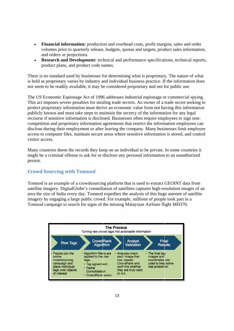
Tomnodsatellitearea theimageryTomnod
Financial ivolumes prand orders Research aproduct pla
s no standaras proprietam to be read
S Economic t imposes seproprietary
y known ane if sensitivition and pre during theto computeraccess.
countries debe a crimina
d Sourcing
d is an exame imagery. De size of Indy by engagid campaign
informationrior to quartor projectio
and Develoans, and pro
rd used by bary varies bydily availab
Espionage evere penal
y informatiod must take
ve informatiroprietary ineir employmr files, main
em the recoal offense to
g with To
mple of a crDigitalGlobdia every dang a large p
n to search f
n: productioerly release
ons. pment: tecduct code n
businesses fy industry a
ble, it may b
Act of 1996lties for stean must deri
e steps to maion is disclonformation
ment or afterntain secure
ords they keo ask for or d
mnod
rowdsourcine’s constell
ay. Tomnod public crowfor signs of
13
on and overe, budgets, q
hnical and pnames.
for determinand individube considere
6 addressesaling trade sive an econoaintain the s
osed. Busineagreementsr leaving theareas wher
eep on an indisclose any
ng platform lation of satexpedites t
d. For examthe missing
rhead costs,quotas and t
performanc
ning what isual businessed proprieta
industrial esecrets. An oomic value secrecy of tesses often rs that restrice company.re sensitive
ndividual to y personal i
that is usedtellites captuthe analysis
mple, milliong Malaysian
profit margtargets, prod
ce specificat
s proprietarys practice. Ifry and not f
espionage oowner of a tfrom not ha
the informatrequire emp
ct the inform Many busiinformation
be private. information
d to extract Gures high-reof this hug
ns of peoplen Airlines fli
gins, sales aduct sales in
tions, techni
y. The naturf the informfor public u
or commercitrade secretaving this intion for anyployees to smation emplinesses limin is stored, a
In some con to an unaut
GEOINT daesolution imge amount oe took part iight MH370
and order nformation,
ical reports,
re of what mation does use.
ial spying. t seeking to nformation y legal ign non-loyees can t employee and control
untries it thorized
ata from mages of an
f satellite in a 0.
,

IV. GEThe GEOobtaininundersta
This migtradecramanufacFrequen
Frequencontend Geograp
Geosp
As you such imperformequally awaitin
A core should nanalysis
Avoidinobscuritand how
EOINT TraOINT Trade
ng informatioanding huma
ght be a branft know-howcturing tradecntly in busine
ntly unique frwith decepti
phic Technol
patial Dece
can imaginmagery. Thisming reconn
true for somg shipment
skill of the not be mistas. Here dece
ng being dety is attaine
w the observ
adecraft craft is uniqu
on of a place an activities a
nch of governw is not uniqucraft would b
ess, this instit
rom geographive informatilogy, GIScien
eption
ne, there ares is particula
naissance bymeone wantin an auto f
GEOINT traken for theeption is de
ceived requed. This knover might m
ue and sometand making
and intention
nment, a busue to an intelbe the confidtutional know
hic analysis ion and opernce, and GE
circumstanarly true in
y concealmeting to denyfactory's pa
radecraft is e error or msigned to ga
uires the anaow-how inclmake a false
14
times privilesense of the
ns.
iness, or a lalligence comdential businwledge is gu
taught in acarate in conditOINT Trade
nces where pa military c
ent, camoufly the abilityarking lot.
contendingmisinformatio
ain an advan
alyst to knowludes how t judgment a
eged organiza information
aw enforcemmmunity. In a
ess knowledarded from a
ademia, the Gtions of secreecraft is illust
people wancontext wheflage, and dey to count th
with decepon you migntage.
w the ways the method about the ca
ational sourcn to support t
ent agency. Ta commercialdge of how toa competitor
GEOINT anaecy. The relatrated below
nt to deny suere we preveeception. Hohe number o
ptive informht deal with
by which cis tailored t
amouflaged
ces and meththe decision m
The implicatl enterprise, o manufactur
as a trade se
alyst may neationship betw
[4].
uccessful anent enemiesowever, it c
of automobi
mation. Deceh in a routin
concealmento a particulobject.
hods for maker in
tion is that
re a product. ecret
ed to ween
nalysis of s from could be les
eption ne spatial
t or lar observerr

15
Geospatial Reasoning
Geospatial reasoning includes processes that support exploration, understanding, and sensemaking. It begins with the ability to use space as a context, or framework, to make sense of what we see. There are three spatial frames within which we can make the transition from what is observed to meaningful information:
Behavioral space is the four-dimensional space-time where spatial thinking is a means of coming to grips with the spatial relations between yourself and objects in the physical environment. This is cognition in space and involves thinking about the world in which we live. It is exemplified by navigation.
Physical space is also built on the four-dimensional world of space-time, but focuses on a scientific understanding of the nature, structure, and function of phenomena. This is cognition about space and involves thinking about the ways in which the world works. An example might be how an earthquake creates a tsunami.
Cognitive space is in relationship to concepts and objects that are not in and of themselves necessarily spatial. This is thinking with space. An example might be an invading army encroaching on national territory, a gang moving into a rival district, or a driver trying to steal a parking space.
Learning to think spatially is to consider objects in terms of their context. This is to say, the object's location in behavioral space, physical space, or cognitive space, to question why objects are located where they are, and to visualize relationships between and among these objects. The key skills of spatial thinking include having the ability to:
Understand the context. The significance of context was discussed above, but it is important to say that if the data upon which the decision is based are placed into the wrong spatial context, for example behavioral space rather than physical space, it is likely the analysis will be flawed since behavioral space is governed by the rules of culture (e.g., use the crosswalks when crossing a street) and physical space is governed by the rules of physics (e.g., I can't walk through a steel fence to cross the road at this point).
Recognize patterns and shapes. The successful spatial thinker needs to retain an image of the simple figure in mind and look for it by suppressing objects irrelevant to the task at hand. This ability allows a geospatial analyst to identify patterns of significance in a map, such as an airfield.
Recall previously observed objects. The ability to recall an array of objects that was previously seen is called object location memory.
Integrate observation-based learning. Synthesizing separately made observations into an integrated whole. The expert analyst moves through the data, gathering information from separately observed objects and views, and integrates this information into a coherent mental image of the area.
Mentally rotate an object and envision scenes from different viewpoints. The ability to imagine and coordinate views from different perspectives has been identified by Piaget and Inhelder (1967) as one of the major instances of projective spatial concepts. Mental rotation ability or perspective-taking ability could be relevant to those analysis tasks that involve envisioning what an object, such as a building, would look like if seen from another position.

16
Challenge of geospatial analysis
Geospatial analysis can be very difficult to do well. The difficulty is cognitive and most frequently not related to an individual's ability to use the tools that Geographic Information Technologies (GIT) provide. GEOINT analysis has two different approaches—the single hypothesis approach and the multiple (or competing) hypotheses approach. The first is most popular in academia; the second is popular in intelligence analysis. Here's a brief comparison:
Single vs. Multiple Hypothesis
Approaches Description
Single Hypothesis The natural human desire to reach an explanation can, and to an interpretation based on a single hypothesis. Human nature is to trust the hypothesis, and the analyst is now blind to other possibilities. The result is a blindness to evidence that disproves the ruling theory or supports an alternate explanation. Here, the results are left to the chance that the original tentative hypothesis was correct.
Multiple Hypotheses These hypotheses should be contradictory and compete so most will prove to be false. The development of multiple hypotheses prior to the analysis avoids the trap of the ruling hypothesis and thus makes it more likely that our analysis will lead to meaningful results. This leads to lines of inquiry that we might otherwise overlook, and thus to evidence and insights that might never have been encountered.
Biases
Good geospatial analysis requires you to monitor your mental progress, make changes, and adapt the ways you are thinking. Richards Heuer [9] makes three important points relative to intelligence analysis:
Human minds are ill equipped ("poorly wired") to cope effectively with both inherent and induced uncertainty.
Increased knowledge of one's own inherent biases tends to be of little assistance to the analyst. Tools and techniques that apply higher levels of critical thinking can substantially improve
analysis of complex problems.
The core of his argument is that even though every analyst sees the same piece of information, it is interpreted differently due to a variety of factors. In essence, one's perceptions are molded by factors that are out of human control. The key risks of mindsets are that:
Analysts perceive what they expect to perceive; Once formed, they are resistant to change; New information is assimilated, sometimes erroneously, into existing mental models; and Conflicting information is often dismissed or ignored.
Ironically, the experienced analysts may be more susceptible to these mindset problems as a result of their expertise and past success in using time-tested mental models. Heuer believes an effective analysis method needs a few safeguards. The analysis method should:
Encourage products that clearly show their assumptions and chains of inferences; and Emphasize procedures that expose alternative points of view.
17
Heuer advocates using Structured Analytic Techniques (SATs) as a means to overcome mindsets.
Structured analytic techniques (SAT)
Most people solve geospatial problems intuitively by trial and error. Structured analytic techniques (SAT) are a "box of tools" to help the analyst mitigate one's cognitive limitations and pitfalls. Structured thinking in general, and structured geospatial thinking specifically, is at variance with the way in which the human mind is in the habit of working. Structured analysis techniques being:
an increased understanding of cognitive limitations and pitfalls that make intelligence analysis difficult;
prominent intelligence failures that have prompted reexamination of how intelligence analysis is generated;
policies expecting interagency collaboration; and a desire by policy makers who receive analysis that it be more transparent as to how conclusions
were reached.
Taken alone, SATs do not constitute an analytic method for solving geospatial analytic problems. The most distinctive characteristic is that structured techniques help to decompose one's geospatial thinking in a manner that enables it to be reviewed, documented, and critiqued.
The US Intelligence Community [7] began focusing on structured techniques because analytic failures led to the recognition that it had to do a better job overcoming cognitive limitations, analytic pitfalls, and addressing the problems associated with mindsets. In the geospatial realm, they ensure that our key geospatial assumptions, biases, and cognitive patterns are not just assumed but are considered.
Moreover, structured techniques provide a variety of tools to help reach a conclusion. Even if intuitive and scientific approaches provide the same degree of accuracy; structured techniques have value in that they can be easily used to balance the art and science of GEOINT. Heuer [8] categorized structured techniques by how they help analysts overcome human cognitive limitations. Heuer's grouping is as follows:
Decomposition and Visualization: The number of things most people can keep in working memory at one time is seven, plus or minus two. Complexity increases geometrically as the number of variables increases. In other words, it is very difficult to do error-free analysis only in our heads. The two basic tools for coping with complexity in the analysis are to: (1) break things down into their component parts so that we can deal with each part separately, and (2) put all the parts down on paper or a computer screen in some organized manner such as a list, matrix, map, or tree so that we and others can see how they interrelate as we work with them.
Indicators, Signposts, Scenarios: The human mind tends to see what it expects to see and to overlook the unexpected. Change often happens so gradually that we do not see it, or we rationalize it as not being of fundamental importance until it is too obvious to ignore. Identification of indicators, signposts, and scenarios create an awareness that prepares the mind to recognize change.
Challenging Mindsets: A simple definition of a mindset is, “a set of expectations through which a human being sees the world.” When this set of expectations turns out to be wrong, it often leads to intelligence failure. Techniques for challenging mindsets include re-framing the question in a way that helps break mental blocks, structured confrontation such as devil’s advocacy and structured self-critique such as what we call a key assumption check. Team discussions help us

18
identify and evaluate new evidence or arguments and expose us to diverse perspectives on the existing evidence or arguments.
Hypothesis Generation and Testing: “Satisficing” is the tendency to accept the first answer that comes to mind that is “good enough.” This is commonly followed by confirmation bias, which refers to looking at the evidence only from the perspective of whether or not it supports a preconceived answer. These are among the most common causes of intelligence failure. Analysis of Competing Hypotheses is one technique for doing this.
Group Process Techniques: Just as analytic techniques provide structure to our individual thought processes, they also provide structure to the interaction of analysts within a team or group. A group is more effective than an individual in generating new ideas, and at least as effective in synthesizing divergent ideas. The specific techniques listed under this category, such as brainstorming and Delphi, are designed as group processes and can only be implemented in a group.
Others have categorized techniques by their purpose:
Diagnostic techniques are primarily aimed at making analytic arguments, assumptions, or intelligence gaps more transparent;
Contrarian techniques explicitly challenge current thinking; and, Imaginative thinking techniques aim to develop alternative outcomes.
The techniques are not a guarantee of analytic precision or accuracy of judgments; they do improve the usefulness, sophistication, and credibility of intelligence assessments.
Sensemaking
The term “sensemaking” [8] is used as a term to describe an analytic process or method. Sherman Kent, who has been described as "the father of intelligence analysis," is often acknowledged as first proposing an analytic method specifically for intelligence. Heuer [9] subsequently proposed an ordered eight-step model of “an ideal” analytic method, emphasizing early deliberate generation of hypotheses prior to information acquisition:
identifying possible hypotheses, listing evidence for and against each hypothesis, analyzing the evidence and then refining hypotheses, trying to disprove hypotheses, analyzing the sensitivity of critical evidence, reporting conclusions with the relative likelihood of all hypotheses, and identifying milestones that indicate events are taking an unexpected course.
Heuer’s technique has become known as Analysis of Competing Hypothesis (ACH). The technique entails identifying possible hypotheses by brainstorming, listing evidence for and against each, analyzing the evidence and then refining hypotheses, trying to disprove hypotheses, analyzing the sensitivity of critical evidence, reporting conclusions with the relative likelihood of all hypotheses, and identifying milestones that indicate events are taking an unexpected course. The ACH matrix might look like:
ACH Matrix
Evidence Hypothesis 1 Hypothesis .....

19
Evidence A
Evidence B
Evidence C
........
An excellent and simple explanation of the ACH approach is found [10] ACH and other problem solving approaches can be said to be applied in three stages. The stages and outputs are: [11]
Analytic Stages Stage Description Result
Stage 1: Problem Initiation
The question focuses on the nature of the geospatial and temporal patterns the analyst is seeking to identify and understand. The question can be viewed as an active two-way discussion between the client requiring the information and the analyst supplying it.
A question that seeks to:
Discover significant and previously unavailable geospatial information.
Describe a place.
Explain why an activity or transaction occurred at a place.
Judge the significance of a place.
Predict the location of geospatial activities.
Stage 2: Information Foraging
This stage recognizes that analysts tended to forage for data by beginning with a broad set of data and then proceeded to narrow that set down into successively smaller, higher-precision sets of data (Pirolli,1999).
The data and information necessary for sensemaking.
Stage 3: Sensemaking It is "a motivated, continuous effort to understand connections (which can be among people, places, and events) in order to anticipate their trajectories and act effectively" (Klein, G., Moon, B. and Hoffman, R.F. 2006). Making sense of sensemaking. IEEE Intelligent Systems, 21(4), 70-73.).
An analytic result.
It is difficult for an analyst to appreciate how various SATs and geospatial tools fit together. The following table summarizes this relationship:
How Various GEOINT Techniques and Tools Fit Together Stage Possible SAT Example Geospatial Technology Operation
Stage 1: Problem Initiation Decomposition and Visualization
Challenging Mindsets
Group Process Techniques
Geospatial data entry
Geospatial data conversion
Data validation
Geospatial data management
Attribute data management
Data visualization
Stage 2: Information Foraging Brainstorming Data visualization
Geospatial data processing/analysis
Stage 3: Sensemaking Indicators, Signposts, Scenarios
Hypothesis Generation and Testing (Analysis of Competing Hypotheses)
Challenging Mindsets
Output of maps and reports

20
Analytic Standards & Judgments
The analytic standards are the core of GEOINT's tradecraft & are characterized [12] by:
1. Objectivity: Analysis should be free of emotional content, give due regard to alternative perspectives and contrary reporting, and acknowledge developments that necessitate adjustments to analytic judgments.
2. Independence of Political Considerations: Analysts should provide objective assessments that are not distorted or altered with the intent of supporting or advocating a particular policy, political viewpoint, or audience.
3. Timeliness: An analyst has a responsibility to be aware of the schedules and requirements of consumers.
4. Use of All Available Sources of Information: Where critical gaps exist, analysts should work to develop appropriate sources and access strategies.
5. Individual Standards of the Analytic Tradecraft. An analytic result
Analytic Standards Individual Standard Description
Properly describes quality and reliability of underlying sources.
Consistent with classification of the product, factors significantly affecting the weighting that the analysis gives to available, relevant information, such as denial and deception, source access, source motivations and bias, age and continued currency of information, or other factors affecting the quality and potential reliability of the information, should be included in the product. When appropriate, analytic products may identify a prospective information strategy to improve the reporting base when significant gaps exist.
Properly caveats and expresses uncertainties or confidence in analytic judgments.
Analytic products should indicate both the level of confidence in analytic judgments and explain the basis for ascribing it. Sources of uncertainty—including information gaps and significant contrary reporting—should be noted and linked logically and consistently to confidence levels in judgments. As appropriate, products also should identify indicators that would enhance or reduce confidence or prompt revision of existing judgments.
Properly distinguishes between underlying intelligence and analysts' assumptions and judgments.
Assumptions comprise the foundational premises on which the information and logical argumentation build to reach analytic conclusions. Assumptions may also span information gaps that would otherwise inhibit the analysis from reaching defensible judgments. Judgments are defined as logical inferences from the available information or the results of explicit tests of hypotheses. They comprise the conclusions of the analysis. Analytic products should explicitly identify the critical assumptions on which the analysis is based and explain the implications for judgments if those assumptions are incorrect. As appropriate, analytic products should identify indicators that would signal whether assumptions or judgments are more or less likely to be correct.
Incorporates alternative analysis where appropriate.
Where appropriate, analytic products should identify and explain the strengths and weaknesses of alternative hypotheses, viewpoints, or outcomes in light of both available information and information gaps. Analytic products should explain how alternatives are linked to key assumptions and/or assess the probability of each alternative. To the extent possible, analysis should incorporate insights from the application of structured analytic technique(s) appropriate to the topic being analyzed and include discussion of key indicators that, if detected, would help clarify which alternative hypothesis, viewpoint, or outcome is more likely or is becoming more likely.
Demonstrates relevance to the domain.
The information and insight may be particularly difficult to obtain without extensive expertise. To meet this standard fully, analytic products should examine and explicitly address direct or near-term implications of the information and judgments for the intended audience.
Uses logical argumentation.
Key points should be effectively supported by information or, for more speculative warning or "think pieces," by coherent reasoning. Language and syntax should convey meaning unambiguously. Graphics and images should be readily understandable and should illustrate, support, or summarize key information or analytic judgments.
Exhibits consistency of analysis over time, or highlights changes and explains rationale.
If the key analytic message has changed, highlight the change and explain its rationale and implications.
Makes accurate judgments and assessments.
Where products are estimative, the analysis should anticipate and correctly characterize the impact and significance of key factors affecting outcomes or situations. Accuracy is sometimes difficult to establish and can only be evaluated retrospectively if necessary information is collected and available.
Expressing Analytic Judgments
It is necessary for decision makers to know how confident their analysts are in the results of an analysis; however, analysts are often reluctant to state the uncertainties surrounding their work because they may not:

21
Appreciate the value of that information to decision makers. Trust the decision maker to understand any caveats as to their confidence in the work. Expect an honest statement of uncertainty to be rewarded. Know how to express the uncertainty.
A report from the DTIC [13] suggests terms and expressions to communicate analytic judgments. The terms selected are based on three factors:
Number of key assumptions required, The credibility and diversity of sourcing, and The strength of argumentation.
Each factor should be assessed independently and then in concert with the other factors to determine the confidence level. Multiple levels are stated as Low, Moderate, and High. Phrases such as "we judge" or "we assess" are used to call attention to a product's key assessment. Supporting assessments may use likelihood terms or expressions to distinguish them from assumptions or reporting.
Guidelines for likeliness terms and the corresponding confidence levels [9]
Low Moderate High
Uncorroborated information from good or marginal sources
Many assumptions Mostly weak logical
inferences, minimal methods application
Glaring intelligence gaps exist
Partially corroborated information from good sources
Several assumptions Mix of strong and weak
inferences and methods Minimal intelligence
gaps
Well corroborated information from proven sources
Minimal assumptions Strong logical
inferences and methods
No or minor intelligence gaps exist
Terms/Expressions Terms/Expressions Terms/Expressions
Possible Could, may, might Cannot judge, unclear
Likely, unlikely Probable, improbable Anticipate, appear
Will, will not Almost certainly,
remote Highly likely, highly
unlikely Expect, assert, affirm

22
Conclusion Location is not just a set of co-ordinates on a map. As explained so far, people are very influenced by their surroundings, the natural, social & cultural settings around them. Adding location information and insights to a business strategy creates a new perspective as we have a new dimension in the analysis of existing data.
Location based software services are now at the forefront of every business. Some of them are
Navigation services from one point to another which adapt to traffic, weather, tourism
Searching for a particular business near one’s location, delivery and pickup of goods
Getting media content such as news, audio, video, websites etc… based on one’s region.
Sorting personal data such as photos, videos, audio by the place of visit.
Recording path of travel for fitness, tourism, work, research, public/private events
The mobile phone has become the main communication & media consumption device especially with the advances in hardware and software. Smartphones are now packed with many sensors such as GPS, NFC, biometric & 4G chipsets to name a few. Most businesses now release software in the form of apps to make use of these technologies to enable e-commerce, mass communication & industrial use. In fact, most of the new startups these days provide their service through a mobile app.
The more the consumers interact with the various apps that use these sensors on their smartphone, the more they become dependent on such advanced services. These very technologies also enable businesses to peek into consumer lives and the smartphone has become a goldmine to aggregate the enormous amounts of data generated to study consumer behavior.
Tracking consumers, their choices and behavior at different locations & subsequent behavior on the mobile is becoming important for business development & strategy. This is more important in a world where speed of execution is important & the trends that consumers follow & adopt keep changing due to the dynamic nature of social media.
The principles of GEOINT which government uses to track, understand & predict the behavior of individuals and groups for reasons of national security can also be used by commercial enterprises.
Such data acquisition and analysis is important as businesses now operate in a very dynamic global environment and especially as laws vary in different countries regarding data collection & tracking of consumer data. Location tracking is an effective way to understand the aggregate behavior of consumers at various places at different points in time.
The GEOINT principles show commercial enterprises ways to set up hardware & software systems, processes & standards to analyze data with location information. It helps make sense of the almost real-time stream of data they receive when consumers interact with their services at various locations.
Ultimately, creating an intelligence system to acquire, process, analyze and predict consumer behavior and patterns will help businesses become more efficient at creating new products and services for their customers while at the same modifying existing products to suit the needs of offering.

23
References [1] BACASTOW, T.S. AND BELLAFIORE, D.J. “Redefining geospatial intelligence” American Intelligence Journal. pp 38-40. (2009)
[2] LOWENTHAL, MARK M. Intelligence: From Secrets to Policy. 3rd ed. CQ Press, (2006)
[3] DAVIS, MICHAEL Profession, Code, and Ethics (2002)
[4] BACASTOW T.S. “GEOINT Lecture Notes MOOC” (2015)
[5] LAURENCE H. SILBERMAN AND CHARLES S. ROBB “Report to the President of the United States” Commission on the Intelligence Capabilities of the United States Regarding Weapons of Mass Destruction GPO WASHINGTON, D.C. 20503 page 584 (March 31, 2005)
[6] JENSEN, J. Remote Sensing of the Environment, 2nd ed. (2007)
[7] CENTRAL INTELLIGENCE AGENCY (2009), A tradecraft primer structured analytic techniques for improving intelligence analysis Washington, D.C., Center for the Study of Intelligence.
[8] MOORE, D. (2012), Sensemaking: A structure for an intelligence revolution (2nd ed.). Washington, DC: National Defense Intelligence College Press.
[9] HEUER, R. (1999), Psychology of intelligence analysis. Washington, D.C.: Center for the Study of Intelligence, Central Intelligence Agency.
[10] WHEATON, KRISTAN J. AND MCMANIS, Diane E. “Structured Analysis of Competing Hypotheses: Improving a Tested Intelligence Methodology” Competitive Intelligence Magazine Vol. 9 No. 6 (Nov-Dec 2006)
[11] CHIDO, DIANE Structured analysis of competing hypotheses: theory and application, Mercyhurst College Institute for Intelligence Studies Press, Erie, PA. (2006)
[12] U.S. Intelligence Community (IC) Directive Number 203, Analytic Standards, (June 21, 2007)
[13] U.S. Joint Publication 2-0, Doctrine for Intelligence Support to Joint Operations (22 October 2013)