A atonay enated SCENIC and HISTORIC BYWAY
28
Your Your Pathway to Pathway to Adventure! Adventure! Your Your Pathway to Pathway to Adventure! Adventure!
Transcript of A atonay enated SCENIC and HISTORIC BYWAY

A Nationally Designated
SCENIC and
HISTORIC BYWAY
www.frontierpathways.comwww.frontierpathways.com719-583-0453719-583-0453
Your Y our Pathway to Pathway to
Adventure!Adventure!
Y our Y our Pathway to Pathway to
Adventure!Adventure!

Rio Grande National Forestand Great Sand Dunes National Park
Sangre de Cristo M
ountains
AlvaradoCampground& Comanche/VenableTrailhead
(Seepage 10)
Horn CreekTrailhead
Grape CreekTrailhead
Music PassTrailhead
CrestonePeak
14,295
G
F
N
JO
P
MHI
KL
Q
RS T
U
EA
D CB
The name of the byway sums it up perfectly…
Frontier…Frontier…At one time, these plains were the far reaches of Spanish, French and American territories.
Pathways…Pathways…You will be following in the footsteps of Ute, Jicarilla Apache, Comanche, Arapahoe, Cheyenne, American and Mexican traders, Lt. Zebulon Pike, John Fremont, Kit Carson, Charles Goodnight, homesteaders, miners, and the first automobile tourists to camp in a National Forest.
Scenic…Scenic…There are vistas of snow-capped mountains, streams, carpets of wildflowers and golden aspens around each turn.
Listen…Listen…to what the 1870 German Colony leader, Carl Wulsten had to say about the area:
One of the most magnificent vales… is undoubtedly “El Mojada,”
or Wet Mountain Valley. Fortune has given the writer a chance
to see almost every country upon this globe, but in all his travels he truthfully can say
that never did he tarry within the limits of any valley or mountain park which equalled
the magnificent beauty and expansive novelty of the grand scenery of “El Mojada…”
So get the camera So get the camera ready and head out ready and head out
on the byway!on the byway!
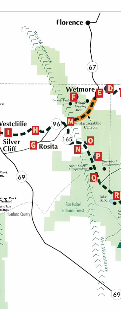
A Goodnight Barn Pg 14
B Lake Pueblo State Park & Visitors Center Pg 14
C Jackson Hill Pg 14
D Jackson Hill Stage Stop Pg 15
E Wetmore and Early Settlements Pg 15
F San Isabel National Forest Pg 15
G Rosita Pg 16
H Sangre de Cristo Mountains (west of Silver Cliff) Pg 16
I Silver Cliff Pg 16
J 1 Westcliffe Pg 17
J 2 Westcliff Denver/ Rio Grande Train Station Pg 17
J 3 The “Westcliff” Schoolhouse Pg 19
K The English Settlement, Hwy 69 Pg 18
L Beckwith Ranch Hwy 69 Pg 18
M MacKenzie Junction Pg 19
N Augusta-Keating High Country Homestead Community Pg 20
O Mingus Homestead Pg 20
P Clarkson Homestead Pg 21
Q Bishop Castle Pg 21
R Lake Isabel Pg 21
S Rye Pg 22
T Colorado City Pg 22
U Cuerño Verde Rest Area and Information Center Pg 22

DrivingDrivingthe Bywaythe BywayThe wishbone shaped byway is 103 miles long, including a 16-mile backtrack. The entire route is a paved, 2-lane highway that is accessible to recreational vehicles. Currently, there are no special provisions for bicycle travel.
You can start your trip in Pueblo, Colorado City or Westcliffe.
Let’s Begin…Let’s Begin…If starting in Pueblo from I-25 take exit 98-B. Using GPS to El Pueblo History Museum, (301 North Union Avenue) visit the byway’s outdoor kiosk, corner of Grand and Victoria. Continue your trip, north on Grand to 4th Street/Highway 96. You’re on your way!
If starting from Colorado City, from I-25 take exit 74 and head west on Highway 165.
If starting at Westcliffe, go east on Highway 96.
The driving time is approximately 2.5 hours.
See a description of each stop along the byway
beginning on page 14
The columbine is Colorado’s state flower. The Colorado Scenic and Historic Byways Commission has adopted the columbine as its logo. As you tour Frontier Pathways, the columbine signs will identify your route.

4
HistoryHistory
Scouts, Charles Dye (1906-1972)
Historical photos courtesy of Pueblo City-County Library District
Silver Cliff Fire Station July 4, 1904
200 block of North Union
Avenue Pueblo
Circa 1915
Evidence of early Paleo Indians has been found in areas along the Byway. In 1806, Lt. Zebulon Pike was on expedition and discovered “Pikes Peak”. Trappers and mountain men made their living from beaver, bison and other animal furs. In 1842, an adobe trading post, simply called “El Pueblo” (town or settlement), was built near the banks of the Arkansas River. The significant location on U.S. territory drew families of mixed nationalities that defined the borderlands region.* In 1858, the Gold Rush brought many European immigrants and a new era of growth and prosperity. From 1872 - 1878 gold and silver were found in Rosita and Silver Cliff. In 1870, Charles Goodnight and Oliver Loving, originators of iconic western cattle drives, drove Longhorn Cattle to Pueblo, where they were loaded on trains to northern markets. Steel making, smelting and railroading made Pueblo a large industrial center that recruited thousands of immigrants to work. With the discovery of silver, Silver Cliff was incorporated in 1879. The Denver Rio Grande Western Railroad extended to Westcliff in 1881. Wetmore remains an unincorporated community though they established their Post Office in 1881. *Borderlands refers to the cultural area along the Arkansas river-border that separated U.S. and Spanish territory, (1803-1821) later, U.S. and Mexican territory (1821-1848).
Looking almost as crowded as a modern day Chile & Frijole Festival, the 200 Block of North Union Ave. is swarming with people, cars, horses and wagons in this circa 1915 photo. The building on the left, at the junction of Victoria, Grand, and Union Ave., was the Kretchmer Triangle Block. It was razed in the 1970’s. The Sister Cities Plaza is now at this location. Photo circa 1915
July 2019
Independence Day
Sunday Monday Tuesday Wednesday Thursday Friday Saturday
1 2 3 4 5 6
7 8 9 10 11 12 13
14 15 16 17 18 19 20
21 22 23 24 25 26 27
28 29 30 31 JuneSu Mo Tu We Th Fr Sa 1 2 3 4 5 6 7 8 9 10 11 12 13 14 15 16 17 18 19 20 21 22 23 24 25 26 27 28 29 30
AugustSu Mo Tu We Th Fr Sa 1 2 3 4 5 6 7 8 9 10 11 12 13 14 15 16 17 18 19 20 21 22 23 24 25 26 27 28 29 30 31

5
Plants & AnimalsPlants & AnimalsAs you drive, see if you can pick out the following life zones – plant and animal communities that change with elevation.
PlainsIt rains less than 15 inches a year on the dry plains. Under 6,000 feet in elevation, look for cottonwood trees only along streams. Jackrabbits and rattlesnakes hide among the yucca and rabbitbrush. Watch for black-billed magpies, turkey vultures and mourning doves flying over herds of pronghorn antelope.
Pronghorn Antelope©1998 Wendy Shattil/ Bob Fozinski
FoothillsBetween 6,000 to 8,000 feet in elevation, more moisture allows trees and shrubs to grow. At the lower elevations, fence lizards and scrub jays lounge among piñon pines and junipers. Higher up, look for northern flickers, wild turkeys and mule deer in the scrub oaks, ponderosa pines and snowberry bushes.
MontaneGreater amounts of snow and rain allow thick forests of Douglas firs and aspens to thrive between 8,000 and 9,500 feet in elevation. In the summertime, you may see mountain bluebirds, Colorado columbines, white false hellebore, heartleaf, arnica and beargrass. Year-round, watch for mountain chickadees, Clark’s nutcrackers, common ravens, elk and bighorn sheep.
Bighorn Sheep ©1998 Wendy Shattil/Bob Fozinski
6
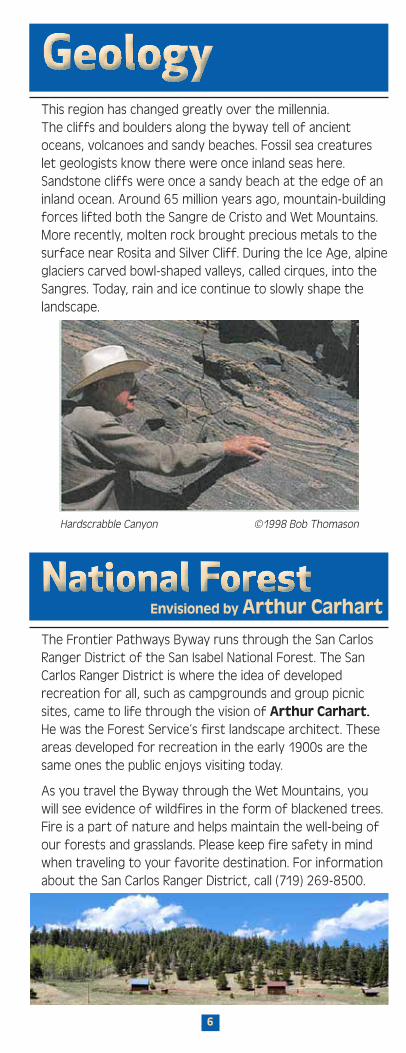
GeologyGeology
National ForestNational ForestHardscrabble Canyon ©1998 Bob Thomason
The Frontier Pathways Byway runs through the San Carlos Ranger District of the San Isabel National Forest. The San Carlos Ranger District is where the idea of developed recreation for all, such as campgrounds and group picnic sites, came to life through the vision of Arthur Carhart. He was the Forest Service’s first landscape architect. These areas developed for recreation in the early 1900s are the same ones the public enjoys visiting today.
As you travel the Byway through the Wet Mountains, you will see evidence of wildfires in the form of blackened trees. Fire is a part of nature and helps maintain the well-being of our forests and grasslands. Please keep fire safety in mind when traveling to your favorite destination. For information about the San Carlos Ranger District, call (719) 269-8500.
This region has changed greatly over the millennia.The cliffs and boulders along the byway tell of ancient oceans, volcanoes and sandy beaches. Fossil sea creatures let geologists know there were once inland seas here. Sandstone cliffs were once a sandy beach at the edge of an inland ocean. Around 65 million years ago, mountain-building forces lifted both the Sangre de Cristo and Wet Mountains. More recently, molten rock brought precious metals to the surface near Rosita and Silver Cliff. During the Ice Age, alpine glaciers carved bowl-shaped valleys, called cirques, into the Sangres. Today, rain and ice continue to slowly shape the landscape.
Envisioned by Arthur Carhart
7
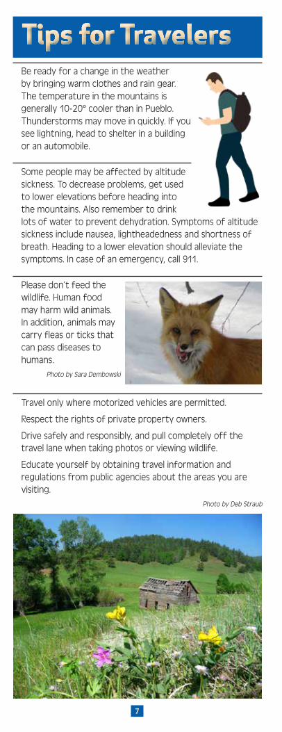
Tips for TravelersTips for TravelersBe ready for a change in the weather by bringing warm clothes and rain gear. The temperature in the mountains is generally 10-20° cooler than in Pueblo. Thunderstorms may move in quickly. If you see lightning, head to shelter in a building or an automobile.
Some people may be affected by altitude sickness. To decrease problems, get used to lower elevations before heading into the mountains. Also remember to drink lots of water to prevent dehydration. Symptoms of altitude sickness include nausea, lightheadedness and shortness of breath. Heading to a lower elevation should alleviate the symptoms. In case of an emergency, call 911.
Please don’t feed the wildlife. Human food may harm wild animals. In addition, animals may carry fleas or ticks that can pass diseases to humans.
Photo by Sara Dembowski
Travel only where motorized vehicles are permitted.
Respect the rights of private property owners.
Drive safely and responsibly, and pull completely off the travel lane when taking photos or viewing wildlife.
Educate yourself by obtaining travel information and regulations from public agencies about the areas you are visiting.
Photo by Deb Straub

8
FacilitiesFacilitiesDavenport Campground
A U.S. Forest Service Camp-ground on Highway 165. For more information about U.S. Forest Service facilities, trails and recreation, contact the San Carlos Ranger District in Cañon City at (719) 269-8500.
Lake Pueblo State ParkThere are 401 sites that accommodate tents, pick-up campers, motor homes and trailers. Dump Stations are available. There are 16 miles of paved trails. Boating, water skiing, swimming and sailboarding are also popular.
Pueblo City Park, Zoo and Swimming PoolPicnic areas, playgrounds, restrooms, dog park, tennis courts, disc golf and much, much more
Lake DeWeeseFour miles north of Westcliffe on County Road 241 Facilities for camping, boating and fishing
Bluff ParkWest end of Main Street, Westcliffe. Picnic tables, restrooms
Westcliffe Town ParkSouth on 4th Street. Restrooms
Greenhorn Meadows CampgroundIn Colorado City on State Highway 165. Thirty sites, electricity, picnic tables, showers and a dump station. For reservations or information call (719) 676-3059. Seasonal.
Lake Beckwith WalkwayAdjacent to the Colorado City Metro District offices off State Highway 165. The 1.4 mile trail is open year-round.
Prairie TrailLocated off State Highway 165 at Craver Middle School. The signed .75-mile-long nature trail is open year-round.
Nature & Wildlife Discovery CenterA multi-campus nature preserve and educational center. Located on the banks of the Arkansas river is the Nature and Raptor Center and located in Beulah Mountain Park is the Mountain Park and Environmental Center. www.natureandraptor.org and www.hikeandlearn.org
Camping, Cabins & RV ReservationsReserve America has tent and RV Camping in the National forests. www.ReserveAmerica.com
Colorado City KOA www.koa.com/campgroundsPueblo KOA Journey www.koa.com/campgroundsRoyal Gorge/Canon City KOA www.koa.com/campgroundsAspen Acres Campgrounds www.aspenacrescampground.com The Pine Lodge www.thepinelodge.netLodge at San Isabel www.lodgesanisabel.comLake Isabel Cabins www.recreation.gov
Davenport Campground

9
NAME OF SITE FACILITIES
NO
. OF
UN
ITS
MA
X LE
NG
TH
OF
SPU
RS
ELEV
ATIO
N
CAMPGROUNDS
Alvarado 48 35’ 9,000 = i I ò 4 Þ v ̂Davenport 12 25’ 8,500 = i I ò Þ vLake Isabel (3) 52 40’ 8,800 = i I ò g 4 Þ vOphir Creek 31 40’ 8,900 = i I ò 4 ÞLake Pueblo SP (P) 113 45” 4,800 = i I ò 4 Þ gLake Pueblo SP (E) 281 100’ 4,800 = i I ò 4 Þ
PICNIC AREAS
Lake Isabel 45 8,800 ¥ I ò Þ O eLake Isabel (GP) 1 8,800 i I ò Þ O R Lake Pueblo 376 4,800 ¥ I ò Þ O eLake Pueblo (GP)(E) 5 4,800 i I ò Þ O R
TRAILHEADS
Alvarado NA 9,000 g 4 ̂ v ÞDavenport NA 8,500 g 4 ̂ ò v ÞGreenhorn Mtn. NA 7,500 g Þ ̂Horn Creek NA 9,400 g 4 ̂ ÞLake Isabel NA 8,800 g i ò 4 ̂ v ÞArkansas Point NA 4,800 g 4 ̂ Þ ò I i
State and Forest Service State and Forest Service Camping, Hiking Camping, Hiking & Picnicking Facilities& Picnicking Facilities
(P) Primitive (E) Elec. Hookups (GP) Group Picnic Area
# BLUE SYMBOL INDICATES BARRIER FREE FACILITIES AVAILABLE
i Fee RequiredR Reservations Required
4 Bicycle Trail
v Motorized Trail
^ Horse Trail
Þ Hiking Trail
e Canoes
= Campgrounds
¥ Picnic Areas
Group Picnic Areas
ò Restrooms
I Drinking Water
O Fishing
g Trailhead
www.reserveamerica.com/articles/camping/take-a-drive-on-a-scenic-byway

10
PuebloPueblo El Pueblo History Museum
El Pueblo History Museum showcases the region’s many cultural and ethnic groups through innovative exhibits including the “Borderlands of Southern Colorado” and the award-winning “Children of Ludlow.” The property includes a re-created 1840s adobe trading post and plaza, and the archaelogical site of the original 1842 El Pueblo trading post. To reach the museum from I-25, take exit 98B and go west for three blocks to 324 West City Center Drive. For admission fees, hours and information, call (719) 583-0453. www.historycolorado.org/el-pueblo-history-museum
Rosemount Museum
In 1893, the John Thatcher family built and lived in this 37-room mansion that still has 85% of its original furniture. 419 West 14th Street. (719) 545-5290 www.rosemount.org
Museums, Riverwalk, Victorian Mansions a Zoo and More!
Pueblo Zoo at City Park
Nature & Wildlife Discovery Center

11
Sangre de Cristo Arts & Conference Center
Four galleries, fine arts, dance programs and the Buell Children’s Museum. 210 North Santa Fe Avenue, Pueblo. Hours: 9:00 am - 5pm Monday - Saturday. (719) 295-7200 www.sdc-arts.org
Historic Arkansas Riverwalk of PuebloThe Historic Arkansas Riverwalk of Pueblo (HARP) is a 32-acre urban waterfront experience open to the public daily. The Arkansas River has been the lifeblood of Pueblo for over 300 years. The Riverwalk project returned the Arkansas River to its historic location at the heart of downtown Pueblo after being diverted in the 1920s due to a devastating flood that destroyed much of Pueblo. The Riverwalk’s current location serves the community offering places to eat, drink and shop, as well as enjoy art and entertainment. Enjoy the beautiful Riverwalk by taking a walk along the pathway. Accessible from Santa Fe, Union Avenue and B Street. www.puebloriverwalk.org
El Pueblo History Museum
Rosemount Museum
Sangre de Cristo Arts & Conference Center & Buell Children’s Museum
Historic Arkansas Riverwalk of Pueblo
Union Avenue Historic District
Pueblo Heritage Museum
Pitkin Avenue Historic District
Steelworks Center of the WestSouth on I-25, off Exit 97A
NW E
S

12
Union Avenue Historic District
Beautifully restored 1880s brick and red sandstone buildings make this one of the most historic half miles in the West. The impressive Union Depot was completed in 1889 for $400,000. The Depot and other historic buildings house apartments, restaurants, shops and galleries. There are interpretive markers along Union Avenue. www.historicpueblo.org/historic-districts/union-ave
Pueblo Heritage Museum
The history of Pueblo’s ethnicity is told through exhibits and stories of immigrants from all over Europe who came to work at the Colorado Coal & Iron Company in the late 1800s. Learn about ranching, railroading, farming, saddle making and more. Hours: 10 am - 4 pm Tuesday - Saturday. 201 West B. Street. (719) 295-1517. www.theheritagecenter.us The Pueblo County Historical Society is located here with the Edward Broadhead Research Library. 203 West B Street. (719) 543-6772. www.pueblohistory.org
Pitkin Place Historic DistrictSeven elegant houses in a row give testament to a grand time in what was a sophisticated city of the 1890s. All seven are in the National Register of Historic Places. They are located on the south side of West Pitkin Avenue in the 300 block. Head southwest on Union Avenue and go right on Pitkin to pass by the historic homes. Continue on Pitkin Avenue to Lincoln Avenue/Highway 96 to continue west on the Byway. www.historicpueblo.org/historic-districts/pitkin-place

13
Pueblo Zoo at City Park The Pueblo City Park and Zoo also contain examples of 1930s construction by the Works Progress Administration. At the zoo, visitors can experience a rainforest, meet rare domestic animals up close in the Pioneer Ranch, and see lions, snakes, bears and many other animals. The zoo is open seven days a week, year-round. 3455 Nuckolls Avenue. Call (719) 561-1452 for hours and fees. www.pueblozoo.org
Nature & Wildlife Discovery Center
Two campuses, one raptor rehabilitation center… and plenty of opportunities for you, your family, and friends to make memories that will last a lifetime! The Nature & Wildlife Discovery Center’s main purpose is to connect kids and the community with nature, through our various events, camps, and educational programs, at each of our locations. River Campus: 5200 Nature Center Road. (719) 549-241 www.natureandraptor.org Mountain Park Campus: 9112 Pueblo Mountain Park Road, Beulah. (719) 485-4444. www.hikeandlearn.org
Steelworks Center of the West
Built in 1901, the museum features exhibits related to Colorado Fuel & Iron and related industries. Learn how CF&I played a part in the history and development of Colorado through the histories of Western industrialization, coal and iron mining, steel production, The Denver & Rio Grande and Colorado and Wyoming railroads, labor issues and Western immigration. 215 Canal Street. (719) 564-9086. www.steelworks.us
14
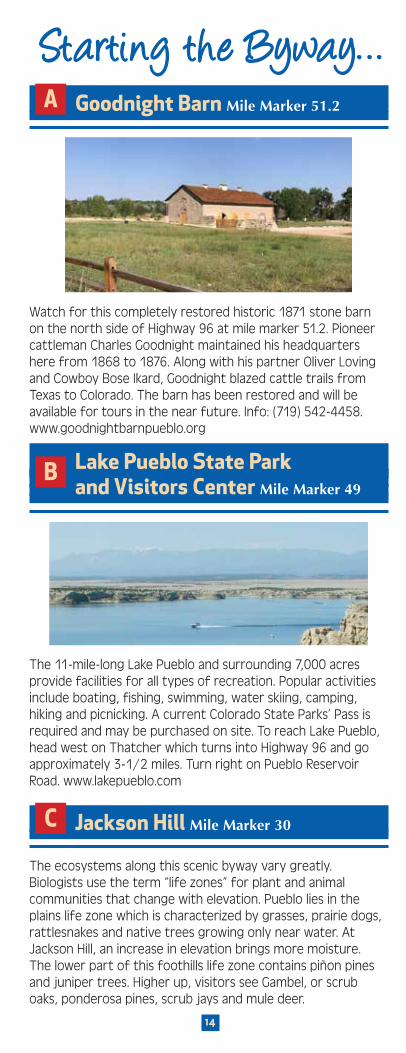
Starting the Byway…Starting the Byway…A Goodnight Barn Mile Marker 51.2
Watch for this completely restored historic 1871 stone barn on the north side of Highway 96 at mile marker 51.2. Pioneer cattleman Charles Goodnight maintained his headquarters here from 1868 to 1876. Along with his partner Oliver Loving and Cowboy Bose Ikard, Goodnight blazed cattle trails from Texas to Colorado. The barn has been restored and will be available for tours in the near future. Info: (719) 542-4458. www.goodnightbarnpueblo.org
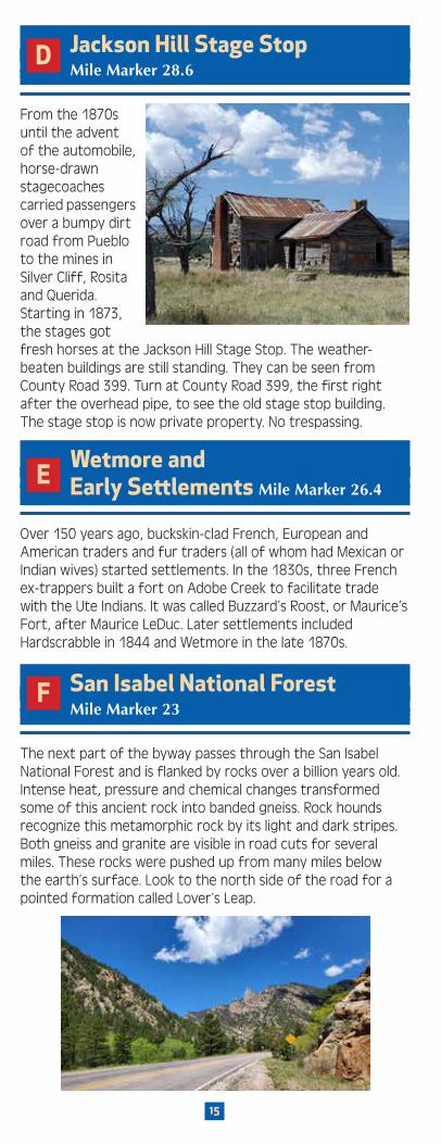
B Lake Pueblo State Park and Visitors Center Mile Marker 49
The 11-mile-long Lake Pueblo and surrounding 7,000 acres provide facilities for all types of recreation. Popular activities include boating, fishing, swimming, water skiing, camping, hiking and picnicking. A current Colorado State Parks’ Pass is required and may be purchased on site. To reach Lake Pueblo, head west on Thatcher which turns into Highway 96 and go approximately 3-1/2 miles. Turn right on Pueblo Reservoir Road. www.lakepueblo.com
C Jackson Hill Mile Marker 30
The ecosystems along this scenic byway vary greatly. Biologists use the term “life zones” for plant and animal communities that change with elevation. Pueblo lies in the plains life zone which is characterized by grasses, prairie dogs, rattlesnakes and native trees growing only near water. At Jackson Hill, an increase in elevation brings more moisture. The lower part of this foothills life zone contains piñon pines and juniper trees. Higher up, visitors see Gambel, or scrub oaks, ponderosa pines, scrub jays and mule deer.
15
D Jackson Hill Stage Stop Mile Marker 28.6
From the 1870s until the advent of the automobile, horse-drawn stagecoaches carried passengers over a bumpy dirt road from Pueblo to the mines in Silver Cliff, Rosita and Querida. Starting in 1873, the stages got fresh horses at the Jackson Hill Stage Stop. The weather-beaten buildings are still standing. They can be seen from County Road 399. Turn at County Road 399, the first right after the overhead pipe, to see the old stage stop building. The stage stop is now private property. No trespassing.
E Wetmore and Early Settlements Mile Marker 26.4
Over 150 years ago, buckskin-clad French, European and American traders and fur traders (all of whom had Mexican or Indian wives) started settlements. In the 1830s, three French ex-trappers built a fort on Adobe Creek to facilitate trade with the Ute Indians. It was called Buzzard’s Roost, or Maurice’s Fort, after Maurice LeDuc. Later settlements included Hardscrabble in 1844 and Wetmore in the late 1870s.
F San Isabel National Forest Mile Marker 23
The next part of the byway passes through the San Isabel National Forest and is flanked by rocks over a billion years old. Intense heat, pressure and chemical changes transformed some of this ancient rock into banded gneiss. Rock hounds recognize this metamorphic rock by its light and dark stripes. Both gneiss and granite are visible in road cuts for several miles. These rocks were pushed up from many miles below the earth’s surface. Look to the north side of the road for a pointed formation called Lover’s Leap.

16
G Rosita Mile Marker 12.8
In 1872, gold and silver were discovered east of present day Silver Cliff. The area was named Rosita, possibly for the small, wild roses then common in the area. By 1875, Rosita was a booming town with 400 buildings and a population of over 1,000. Today, several of the original buildings remain. Rosita is located on County Road 328, south of Highway 96.
H Sangre de Cristo Mountains Mile Marker 5.5
Miners, ranchers and modern-day motorists have all marvelled at this breathtaking view of the Sangre de Cristos. This 50-mile-stretch includes 22 peaks that are over 13,000 feet in elevation.
I Silver Cliff Mile Marker 1
Silver ore was first discovered in black stained cliffs in 1878, and the town of Silver Cliff was incorporated in 1879 as a mining town. By 1880, Silver Cliff was the third largest town in Colorado with a population of 5,040 people. The Silver Cliff Museum is located in an 1879 building that once served as Silver Cliff’s original town hall and firehouse. Today, it houses artifacts depicting a history and life that revolved around mining, ranching and the homesteading way of life. 620 Main Street, Silver Cliff. (719) 783-2615.

17
J 1 Westcliffe Mile Marker 0
The Denver and Rio Grande Railroad planned to lay tracks into the valley in the early 1880s. Insiders bought up land just west of Silver Cliff before the railway was completed. When the terminal was built in what would become Westcliffe, Dr. William Bell and other investors presumably made a tidy profit.
J 2 Westcliff Denver/ Rio Grande Train Station
All Aboard Westcliffe Inc. preserves the Wet Mountain Valley’s railroad history of Westcliffe’s branch of the Denver & Rio Grande Railroad, which operated from 1901 to 1939. The Denver Rio Grande came to Westcliffe in 1880-89 for the narrow gauge, then from 1901-1939 for the standard gauge. Visitors can enjoy the Depot & Engine House Museums along with restored rail cars and a wonderful model train display. www.allaboardwestcliffe.org Facebook - All Aboard Westcliffe
Photo courtesy of Jim Bistodeau

18
K The English Settlement Hwy 69, Mile Marker 63.2
Photo courtesy of Cheri Young
The oldest town in the valley began as a supply center for ranchers located in an area northwest of Westcliffe known as Ula, or “The English Settlement.” Ranchers and homesteaders first moved to the area in 1869. Early settlers included the Kennicotts whose cabin can be seen from State Highway 69 just north of Westcliffe. By 1871, the little town of Ula had a post office, general store and hotel. At its peak, Ula’s population was 365 people. Today, all that remains are a cemetery and cabin.
L Beckwith Ranch Hwy 69, Mile Marker 64.1
The Beckwith Ranch is easily visible from State Highway 69 north of Westcliffe. At the turn of the century, it was the largest cattle and horse operation in the region. In 1871, Edwin Beckwith built a log cabin and homesteaded the land. Soon, he brought in 1,500 head of Texas cattle. Edwin was soon joined by his brother Elton. The Beckwiths owned nearly 7,000 head of cattle and 200 horses by 1885. They built their unusually-styled house around the original log cabin. At its height, the Beckwith Ranch encompassed 60,000 acres. It is on the National Register of historic places. 64161 Highway 69 North, Westcliffe, www.beckwithranch.org Open by appointment only. For tours, email: [email protected]

19
J 3 The “Westcliff” Schoolhouse
The “Westcliff” Schoolhouse, listed on the National Register of Historic Places, is located on south 4th Street in Westcliffe. It was built in 1891 and was dedicated on Christmas Eve of the same year. Area historians have it set up to look as it did in 1891. No one knows why the school name, still visible above the front door as “Westcliff,” was spelled without the “e.” Hours intermittent, contact Custer County Historian. 302 South 4th Street, Westcliffe.
M MacKenzie Junction Mile Marker 18
This junction has seen many travellers over the centuries–Ute Indians, early trappers, scouts like Kit Carson, explorers, the Espinosa brothers and many others. In the late 1800s, Angus MacKenzie ranched here; now the Hardscrabble Ranch stands in its place. From here, you may choose to follow the byway to Pueblo (36 miles), to Westcliffe (16 miles) or through Rye to Colorado City (35 miles).
Hardscrabble Creek near Mackenzie JunctionPhoto courtesy of Pueblo City-County Library District

20
N Augusta-Keating High Country
Homestead Community Mile Marker 3-11.5
By 1880, the best farming land in the lower elevations had been claimed. What was left included the snowy 9,000-foot-high valleys along the spine of the Wet Mountains. Edwin Drake was appointed as the first postmaster of Augusta in 1889. The post office was a room attached to the front of Drake’s house. Residents exchanged news and gossip at the post office until 1902. It was re-established in 1914, but was renamed “Keating.” The original Drake Homestead which served as the Augusta and Keating post offices still stands on Highway 165 several miles south of MacKenzie Junction.
O Mingus Homestead Mile Marker 8.9
A Scandinavian master builder constructed this enduring homestead in 1908. It was listed on the National Register of Historic Places in 1990. The tight dove-tailed corners show his excellent workmanship. The building was home to Al Mingus, his wife and 2 daughters. The homestead is south of the Bigelow Divide. Turn east on the gravel Forest Service Road 383 near mile marker 11. Stay to the right when the road forks. The weathered, gray buildings are 1 mile off Highway 165. The homestead is owned by the U.S. Forest Service. Currently, visitors may only look at and photograph the barn and house from the outside; however, it is available to rent from April 1st - November 30th for overnight stays at www.recreation.gov

21
P
Clarkson Homestead Mile Marker 11.1
The carpenter who built the Mingus Homestead also built James Clarkson’s house and barn. Clarkson ran a general store and post office and farmed. The Clarkson Homestead is easily visible just off Highway 165, one-half mile north of Ophir Creek Campground.
Q Bishop Castle Mile Marker 12.6
Many travellers are surprised to find a castle in the Colorado mountains. This one-man project was started by Jim Bishop in 1969. All of the work has been done with a wheelbarrow and shovel. The castle is part of a non-profit organization. This free attraction is open 24 hours a day, seven days a week, year-round.
R Lake Isabel Mile Marker 18.7
In 1919, the Forest Service’s first landscape architect, Arthur Carhart, proposed some radical changes using the San Isabel area as a model for the rest of the nation. They included the concept of integrated planning of new automobile roads to auto camps, tent camps, planned improved and new campsites, and look-out points. In addition, several recreational cabins were built in the 1920s near what is now Lake Isabel. Visitors can see several of the cabins behind The Lodge at San Isabel, which was once a mess hall for Civilian Conservation Corps workers. Civilian Conservation Corps workers built the St. Charles dam in 1936. On opening day, 500 automobiles drove up for the festivities. Just as in the past, people today enjoy fishing and boating at Lake Isabel. Lodging and restaurant available. Photo by David Hayden

22
S Rye Mile Marker 28.5
This small foothills community, established around 1870, was first named Table Top Mountain. The name was changed to Rye after the post office department in Washington complained that the name was too long. At one time, the Rye area was renowned for its dairies and numerous sawmills.
Just southeast of Rye, in the late 1960s, on a small stream south of the old fish hatchery, the last surviving population of the Arkansas River Colorado Greenback Cutthroat Trout was discovered. Until then, this native trout had been thought to be extinct. The fish found in Apache Creek were nurtured. They have now been reintroduced into 19 creeks in Colorado. In 1994, the state legislature designated the Colorado Greenback Cutthroat Trout as the official state fish.
T Colorado City Mile Marker 34
Holland Duell, a local rancher, introduced Colorado’s first planned development concept at Colorado City. It began in 1963. Roads were carefully laid out and planning was done for future growth. Colorado City today includes a golf course, shopping center, and opportunities for swimming, boating and fishing in Lake Beckwith.
U Cuerño Verde Rest Area and Information Center Mile Marker 36.7
The name Cuerño Verde, or Greenhorn, honors a Comanche chief of the 1700s. For years, his Jupe band attacked many Spanish settlements in retaliation for his father’s death. To stop the deadly raids, Spanish General Juan Bautista de Anza led an expedition against the Comanches. In August of 1779, 600 men including Allied Pueblo Indians left Santa Fe, to be joined by 200 Utes and Apache. The force successfully attacked a Comanche camp south of Colorado Springs. Later, at the base of Greenhorn Mountain, and possibly near present-day Greenhorn Meadows Park, de Anza encountered Cuerño Verde and 50 warriors. The Chief and his warriors put a brave defense, but the Spanish killed their foe.

Rio Grande National Forestand Great Sand Dunes National Park
Sangre de Cristo M
ountains
AlvaradoCampground& Comanche/VenableTrailhead
(Seepage 10)
Horn CreekTrailhead
Grape CreekTrailhead
Music PassTrailhead
CrestonePeak
14,295
G
F
N
JO
P
MHI
KL
Q
RS T
U
EA
D CB
The name of the byway sums it up perfectly…
Frontier…Frontier…At one time, these plains were the far reaches of Spanish, French and American territories.
Pathways…Pathways…You will be following in the footsteps of Ute, Jicarilla Apache, Comanche, Arapahoe, Cheyenne, American and Mexican traders, Lt. Zebulon Pike, John Fremont, Kit Carson, Charles Goodnight, homesteaders, miners, and the first automobile tourists to camp in a National Forest.
Scenic…Scenic…There are vistas of snow-capped mountains, streams, carpets of wildflowers and golden aspens around each turn.
Listen…Listen…to what the 1870 German Colony leader, Carl Wulsten had to say about the area:
One of the most magnificent vales… is undoubtedly “El Mojada,”
or Wet Mountain Valley. Fortune has given the writer a chance
to see almost every country upon this globe, but in all his travels he truthfully can say
that never did he tarry within the limits of any valley or mountain park which equalled
the magnificent beauty and expansive novelty of the grand scenery of “El Mojada…”
So get the camera So get the camera ready and head out ready and head out
on the byway!on the byway!
A Goodnight Barn Pg 14
B Lake Pueblo State Park & Visitors Center Pg 14
C Jackson Hill Pg 14
D Jackson Hill Stage Stop Pg 15
E Wetmore and Early Settlements Pg 15
F San Isabel National Forest Pg 15
G Rosita Pg 16
H Sangre de Cristo Mountains (west of Silver Cliff) Pg 16
I Silver Cliff Pg 16
J 1 Westcliffe Pg 17
J 2 Westcliff Denver/ Rio Grande Train Station Pg 17
J 3 The “Westcliff” Schoolhouse Pg 19
K The English Settlement, Hwy 69 Pg 18
L Beckwith Ranch Hwy 69 Pg 18
M MacKenzie Junction Pg 19
N Augusta-Keating High Country Homestead Community Pg 20
O Mingus Homestead Pg 20
P Clarkson Homestead Pg 21
Q Bishop Castle Pg 21
R Lake Isabel Pg 21
S Rye Pg 22
T Colorado City Pg 22
U Cuerño Verde Rest Area and Information Center Pg 22
A Nationally Designated
SCENIC and
HISTORIC BYWAY
www.frontierpathways.comwww.frontierpathways.com
For More InformationColorado City Metropolitan District (719) 676-3396
Custer County Tourism Visit www.custercounty.com
Frontier Pathways Scenic Byway www.FrontierPathways.com
Greenhorn Valley Chamber of Commerce (719) 676-3000
Pueblo Visitor Information Center 310 Central Main Street, (719) 283-8200 www.puebochamber.org/guide
San Carlos Ranger District, San Isabel National Forest (719) 269-8500
Thanks to the Colorado Tourism Office for the development and printing of this brochure
Your Y our Pathway to Pathway to
Adventure!Adventure!
Y our Y our Pathway to Pathway to
Adventure!Adventure!
Food and DrinkAvailable in Pueblo, Silver Cliff, Westcliffe and Colorado City
Service StationsAvailable in Pueblo, Silver Cliff, Westcliffe and Colorado City
LodgingAvailable in Pueblo, Silver Cliff, Westcliffe, San Isabel (seasonally) and Colorado City
Hollydot in Colorado City (719) 676-3341
Elmwood Golf Course at Pueblo City Park (719) 561-4946
Desert Hawk Golf Course, Pueblo West (719) 547-2280
Walking Stick Golf Course, Pueblo (719) 553-1181
Golf CoursesGolf Courses
Heritage Tours of Southern ColoradoHeritage Tours of Southern Colorado An Enterprise of Frontier Pathways Byway
Cowboys to Castles: (Most popular)View ranches in wide-open ranges at the foot of the Sangre de Cristo Mountains. Visit Goodnight Barn, Historic Beckwith Ranch, and family-owned Music Meadows Ranch. Enjoy a meal of grass-fed beef in the original chink-and-log barn. In Westcliffe, soak up the Western atmosphere in art galleries, and shops. Final stop: Bishop Castle in Rye, a medieval-like wonder in the 21st-century. Continue through San Isabel National Forest. View wildflowers, meadows, wildlife, and old homesteads.
Heritage Farm Tours: (1/2 day van tour)Pueblo’s farms are a destination for many travelers, including chile aficionados. The authentic roadside markets offer products from dry sausages, cheese, honey, ethnic foods and pastries made on site. Learn the family stories of DiTomaso, Mauro and Musso Farms, followed by lunch, “where the locals eat”. Ask about our tours during Pueblo’s Chile & Frijoles Festival every September!
Royal Gorge Bridge: (1/2 day tour)Take in Colorado’s awe-inspiring Royal Gorge Bridge that spans a half mile across the gorge over the roaring Arkansas River. This trip is perfect for pre- or post-conference tours or reunions. Activities at the park include: the bridge, aerial tram and incline railway. The zip line is on your own. A leisurely lunch can be enjoyed inside the Visitor Center Restaurant or on the patio. If preferred, dinner can be arranged in Pueblo on the Riverwalk after an afternoon tour.
For More Tours and Info Visit Our Website: www.frontierpathways.com
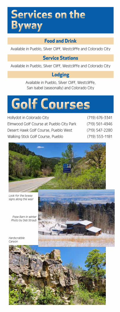
Services on the Services on the BywayByway
Photo by Rowedean Doss
Look for the byway signs along the way!
Pope Barn in winter Photo by Deb Straub
Hardscrabble Canyon

A Nationally Designated
SCENIC and
HISTORIC BYWAY
www.frontierpathways.comwww.frontierpathways.com
For More InformationColorado City Metropolitan District (719) 676-3396
Custer County Tourism Visit www.custercounty.com
Frontier Pathways Scenic Byway www.FrontierPathways.com
Greenhorn Valley Chamber of Commerce (719) 676-3000
Pueblo Visitor Information Center 310 Central Main Street, (719) 283-8200 www.puebochamber.org/guide
San Carlos Ranger District, San Isabel National Forest (719) 269-8500
Thanks to the Colorado Tourism Office for the development and printing of this brochure
Your Y our Pathway to Pathway to
Adventure!Adventure!
Y our Y our Pathway to Pathway to
Adventure!Adventure!
Food and DrinkAvailable in Pueblo, Silver Cliff, Westcliffe and Colorado City
Service StationsAvailable in Pueblo, Silver Cliff, Westcliffe and Colorado City
LodgingAvailable in Pueblo, Silver Cliff, Westcliffe, San Isabel (seasonally) and Colorado City
Hollydot in Colorado City (719) 676-3341
Elmwood Golf Course at Pueblo City Park (719) 561-4946
Desert Hawk Golf Course, Pueblo West (719) 547-2280
Walking Stick Golf Course, Pueblo (719) 553-1181
Golf CoursesGolf Courses
Heritage Tours of Southern ColoradoHeritage Tours of Southern Colorado An Enterprise of Frontier Pathways Byway
Cowboys to Castles: (Most popular)View ranches in wide-open ranges at the foot of the Sangre de Cristo Mountains. Visit Goodnight Barn, Historic Beckwith Ranch, and family-owned Music Meadows Ranch. Enjoy a meal of grass-fed beef in the original chink-and-log barn. In Westcliffe, soak up the Western atmosphere in art galleries, and shops. Final stop: Bishop Castle in Rye, a medieval-like wonder in the 21st-century. Continue through San Isabel National Forest. View wildflowers, meadows, wildlife, and old homesteads.
Heritage Farm Tours: (1/2 day van tour)Pueblo’s farms are a destination for many travelers, including chile aficionados. The authentic roadside markets offer products from dry sausages, cheese, honey, ethnic foods and pastries made on site. Learn the family stories of DiTomaso, Mauro and Musso Farms, followed by lunch, “where the locals eat”. Ask about our tours during Pueblo’s Chile & Frijoles Festival every September!
Royal Gorge Bridge: (1/2 day tour)Take in Colorado’s awe-inspiring Royal Gorge Bridge that spans a half mile across the gorge over the roaring Arkansas River. This trip is perfect for pre- or post-conference tours or reunions. Activities at the park include: the bridge, aerial tram and incline railway. The zip line is on your own. A leisurely lunch can be enjoyed inside the Visitor Center Restaurant or on the patio. If preferred, dinner can be arranged in Pueblo on the Riverwalk after an afternoon tour.
For More Tours and Info Visit Our Website: www.frontierpathways.com
Services on the Services on the BywayByway
Photo by Rowedean Doss
Look for the byway signs along the way!
Pope Barn in winter Photo by Deb Straub
Hardscrabble Canyon