9th Workshop on Hyperspectral Image and Signal …€¦ · trotechnique Informatique Hydraulique...
44
9th Workshop on Hyperspectral Image and Signal Processing : Evolution in Remote Sensing 23-26 September 2018, Amsterdam, The Netherlands Workshop Program
Transcript of 9th Workshop on Hyperspectral Image and Signal …€¦ · trotechnique Informatique Hydraulique...
9th Workshop on Hyperspectral Image and Signal Processing : Evolution in Remote Sensing
23-26 September 2018, Amsterdam, The Netherlands
Workshop Program
perClass MiraMaking sense of spectral imaging
‣ Easy-to-use GUI
‣ Automatic state-of-the-art Machine Learning
‣ No programming or ML expertise needed
‣ Deploy solutions in custom applications
‣ Fast GPU processing
Request demo at http://perclass.com
HarrisGeospatial.com
GEOSPATIAL DATA, ANALYTICS, AND SCIENTIFIC PROGRAMMINGWhether you need a finished geospatial product, a scientific solution, or data and analytics to support a project, Harris Geospatial Solutions can meet your needs.
©2018 Harris Geospatial Solutions, Inc. All rights reserved.
Table of contents
Committees 4
Technical sponsors 7
Conference Info 5
Plenary speakers 8
Tutorials 11
Sunday, 23 Overview 16
WHISPERS at a glance 15
Sunday, 23 17
Monday, 24 Overview 18
Monday, 24 19
Tuesday, 25 Overview 24
Wednesday, 26 Overview 32
Tuesday, 25 25
Wednesday, 26 33
2018Amsterdam, The Netherlands
4 - Whispers Conference 2018, Amsterdam, The Netherlands
Committees
General chairs Xiaoxiang Zhu, German Aerospace Center (DLR) and Technical University of Munich (TUM), Germany Jocelyn Chanussot, Grenoble Institute of Technology, FranceProgram chair Prof Yanfeng Gu, Harbin Institute of Technology, Harbin, China
Technical committee Jon Benediktsson, University of Iceland, Iceland Jose Bioucas-Dias, Instituto de Telecomunicações, Portugal Xavier Briottet, The French Aerospace Lab, France Lorenzo Bruzzone, University of Trento, Italy Jocelyn Chanussot, Grenoble Institute of Technology, France Melba Crawford, Purdue University, USA Yannick Deville, Inst. de Recherche en Astrophysique et Planétologie, France Peijun Du, Nanjing University, China Qian Du, Mississippi State University, USA Paolo Gamba, University of Pavia, Italy Richard Gloaguen, Helmholtz Institute Freiberg for Resource Technology Yanfeng Gu, Harbin Institute of Technology, China Uta Heiden, German Aerospace Center (DLR) Rob Heylen, University of Antwerp, Belgium Xiuping Jia, UNSW Canberra at the Australian Defence Force Academy, Australia John Kerekes, Rochester Institute of Technology, USA Muhammad Murtaza Khan, NUST-SEECS, Pakistan Wenzhi Liao, Ghent University, Belgium
Sebastian Lopez, Universidad de las Palmas de Gran Canarias, SpainRupert Müller, German Aerospace Center (DLR)Nasser Nasrabadi, West Virginia University, USAMario Parente, University of Massachusetts, USAAntonio Plaza, University of Extremadura, SpainSaurabh Prasad, University of Houston, USAStanley Rotman, Ben-Gurion University of the Negev, IsraelAlan Schaum, Naval Research Laboratoy, USAPaul Scheunders, Vision Lab - University of Antwerp, BelgiumJames Theiler, BLos Alamos National Laboratory, USAJean-Yves Tourneret, INP-Ecole Nationale Supérieure Electronique Elec-trotechnique Informatique Hydraulique Toulouse, FranceMiguel Velez-Reyes, University of Texas at El Paso, USANaoto Yokoya, The University of Tokyo, JapanAlina Zare, University of Missouri, USABing Zhang, Institute of Remote Sensing & Digital Earth, ChinaXiaoxiang Zhu, German Aerospace Center (DLR) and Technical University of Munich (TUM), Germany
Multimedia Vincent Couturier-Doux
Whispers Conference 2018, Amsterdam, The Netherlands - 5
Conference information
Conference Venue Amsterdam Conference Centre Beurs van Berlage Damrak 243 1012 ZJ Amsterdam The Netherlands
T +31 (0)20 - 530 41 41 [email protected] www.beursvanberlage.com
Taxi There are taxi stops right next to Beurs van Berlage, at the Oudebrugsteeg. You can order a cab at the Taxi Centrale Amsterdam, 020 - 777 77
Tram Stop : Dam (Bijenkorf) Trams : 4, 9, 16, 24, 25 Walking : 1 minute Stop : Dam (Magnaplaza) Trams : 10, 13, 14, 17 Walking : 5 minute
Arrival from Amsterdam Schiphol Airport From Amsterdam Schiphol Airport, you can reach Amsterdam Conference Centre Beurs van Berlage by train or taxi. If you are travelling by train, you can buy a ticket to Amsterdam Centraal Station in the Arrivals Hall of Schiphol. The trains leave four times every hour and the journey takes about fifteen minutes. If you take a taxi, you can state “Beurs van Berlage” as your destination. The address is: Damrak 243. The drive takes about twenty-five minutes.
Arrival from Amsterdam Centraal Station Beurs van Berlage is 300 metres away, about a five minute walk. You can see Beurs van Berlage on the Damrak in front of you when you leave the Central Station along the Stationsplein (Station square) and head out towards the Dam from there.
Bus Stop : Dam (Bijenkorf) Bus : 355, 357, 359, 361, 363 Walking : 1 minute Stop : Dam/Raadhuisstraat Bus : 170, 170, 174, 272, 352, 354,358, N70 Walking : 5 minute
For an up-to-date timetable, go to www.gvb.nl
Car The ideal way to reach the city centre of Amsterdam is to park your car at a P+R-location at the edge of the city, and use public transportation the rest of the way. If you come from the northeast, east or southeast of the Netherlands, it is best to use the P+R Zeeburg. Accessible via Ring A10, exit S114. If you come from the northwest or west of the Netherlands, it is best to park at P+R Sloterdijk. Accessible via Ring A10, exit S103.Parking centrum Oosterdok- Oosterdokstraat 150, 1011 DK Amsterdam- 1.700 parking spaces- Maximum vehicle height 2.10 m / 6ft 11in- Opening hours 24 hours, 7 days a week- For rates please check the websitewww.parkingcentrumoosterdok.nl
Parking garage Q-Park Bijenkorf:- Beursplein 15, 1012 JW Amsterdam- Immediately next to Beurs van Berlage- 400 parking spaces- Maximum vehicle height 1.80 m / 5ft 11in- Opening hours 24 hours, 7 days a week- For rates please check the website www.q-park.nl
Disabled accessBeurs van Berlage is largely accessible for disabled people. Unfortunately, Beurs van Berlage has no special disabled parking spaces. However, there is a Bijenkorf carpark right next to Beurs van Berlage. The Beurs van Berlage Toren (Tower) is only accessible by stairs.

6 - Whispers Conference 2018, Amsterdam, The Netherlands
Conference information
Internet Free Wi-Fi is available in the whole building and its password will be provided on-site.
Registration Desk Sunday, 23 : from 9:00 to 18:00 Monday, 24 to Wednesday, 26 : from 8:00 to 18:00 Onsite registration : cash and credit card accepted
Speaker Preparation Software: Each lecture hall is equipped with Office and Acrobat reader.
• File types: We accept .ppt, .pptx or .pdf formats.
• Loading your presentation: Please go to the appropriate lecture hall to upload your presentation BEFORE the start of your session. A Whisperer will be there to assist you as needed.
Poster Preparation Set-up: Please arrive each day at the opening to set-up your poster. Whisperers will be there to assist you.
• Break-down: Please remove your poster at the end of the day, to free the spot for the next day’s posters.
• Presentation: speaker should be alongside the poster during the coffee breaks.
• Size: max posters size is A0 (841 × 1189 mm).
Whispers Conference 2018, Amsterdam, The Netherlands - 7
Technical sponsors
ESA (http://www.esa.int/ESA)The European Space Agency (ESA) is Europe’s gateway to space. Its mission is to shape the development of Europe’s space capability and ensure that investment in space continues to deliver benefits to the citizens of Europe and the world.ESA is an international organisation with 22 Member States. By coordinating the financial and intellectual resources of its members, it can undertake programmes and activities far beyond the scope of any single European country.
IEEE - GRSS (http://www.grss-ieee.org) The fields of interest of the IEEE Geoscience and Remote Sensing Society are the theory, concepts, and techniques of science and engineering as they apply to the remote sensing of the earth, oceans, atmosphere, and space, as well as the processing, interpretation and dissemination of this information.
DLR (https://www.dlr.de) The German Aerospace Center (DLR) is the national aeronautics and space research centre of the Federal Republic of Germany. Its extensive research and development work in aeronautics, space, energy, transport, digitalisation and se-curity is integrated into national and international cooperative ventures. In addition to its own research, as Germany’s space agency, DLR has been given responsibility by the federal government for the planning and implementation of the German space programme. DLR is also the umbrella organisation for the nation’s largest project management agency.TUM (https://www.tum.de) The Technical University of Munich (TUM) combines top-class facilities for cutting-edge research with unique lear-ning opportunities for students. It is committed to finding solutions to the major challenges facing society as we move forward: Health & Nutrition • Energy & Natural Resources • Environment & Climate • Information & Communications • Mobility & Infrastructure. The university thinks and acts with an entrepreneurial spirit. Its aim: to create lasting value for society. All this combines to make it one of Europe’s leading universities.
IEEE (https://www.ieee.org) IEEE and its members inspire a global community to innovate for a better tomorrow through highly cited publications, conferences, technology standards, and professional and educational activities. IEEE is the trusted “voice” for enginee-ring, computing, and technology information around the globe.
8 - Whispers Conference 2018, Amsterdam, The Netherlands
Plenary speakers
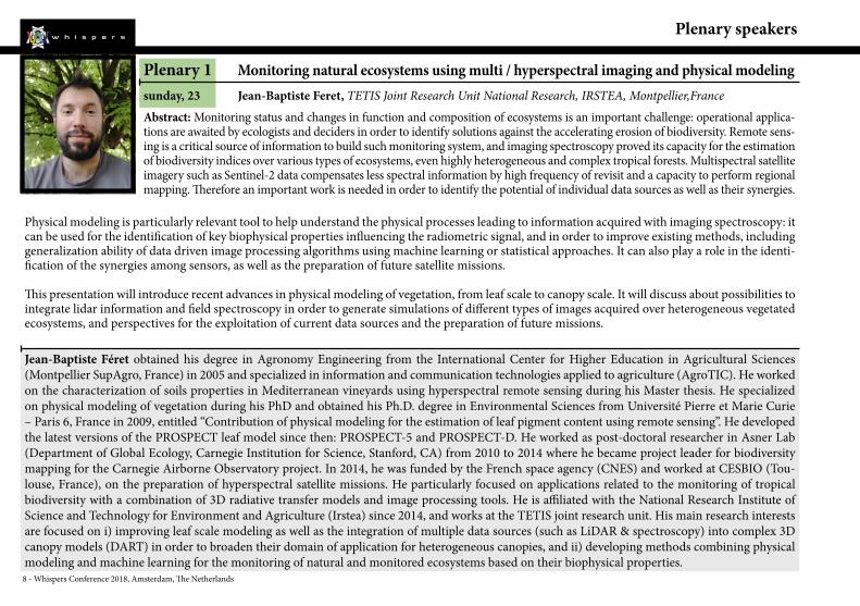
Plenary 1 Monitoring natural ecosystems using multi / hyperspectral imaging and physical modelingsunday, 23 Jean-Baptiste Feret, TETIS Joint Research Unit National Research, IRSTEA, Montpellier,FranceAbstract: Monitoring status and changes in function and composition of ecosystems is an important challenge: operational applica-tions are awaited by ecologists and deciders in order to identify solutions against the accelerating erosion of biodiversity. Remote sens-ing is a critical source of information to build such monitoring system, and imaging spectroscopy proved its capacity for the estimation of biodiversity indices over various types of ecosystems, even highly heterogeneous and complex tropical forests. Multispectral satellite imagery such as Sentinel-2 data compensates less spectral information by high frequency of revisit and a capacity to perform regional mapping. Therefore an important work is needed in order to identify the potential of individual data sources as well as their synergies.
Physical modeling is particularly relevant tool to help understand the physical processes leading to information acquired with imaging spectroscopy: it can be used for the identification of key biophysical properties influencing the radiometric signal, and in order to improve existing methods, including generalization ability of data driven image processing algorithms using machine learning or statistical approaches. It can also play a role in the identi-fication of the synergies among sensors, as well as the preparation of future satellite missions.
This presentation will introduce recent advances in physical modeling of vegetation, from leaf scale to canopy scale. It will discuss about possibilities to integrate lidar information and field spectroscopy in order to generate simulations of different types of images acquired over heterogeneous vegetated ecosystems, and perspectives for the exploitation of current data sources and the preparation of future missions.
Jean-Baptiste Féret obtained his degree in Agronomy Engineering from the International Center for Higher Education in Agricultural Sciences (Montpellier SupAgro, France) in 2005 and specialized in information and communication technologies applied to agriculture (AgroTIC). He worked on the characterization of soils properties in Mediterranean vineyards using hyperspectral remote sensing during his Master thesis. He specialized on physical modeling of vegetation during his PhD and obtained his Ph.D. degree in Environmental Sciences from Université Pierre et Marie Curie – Paris 6, France in 2009, entitled “Contribution of physical modeling for the estimation of leaf pigment content using remote sensing”. He developed the latest versions of the PROSPECT leaf model since then: PROSPECT-5 and PROSPECT-D. He worked as post-doctoral researcher in Asner Lab (Department of Global Ecology, Carnegie Institution for Science, Stanford, CA) from 2010 to 2014 where he became project leader for biodiversity mapping for the Carnegie Airborne Observatory project. In 2014, he was funded by the French space agency (CNES) and worked at CESBIO (Tou-louse, France), on the preparation of hyperspectral satellite missions. He particularly focused on applications related to the monitoring of tropical biodiversity with a combination of 3D radiative transfer models and image processing tools. He is affiliated with the National Research Institute of Science and Technology for Environment and Agriculture (Irstea) since 2014, and works at the TETIS joint research unit. His main research interests are focused on i) improving leaf scale modeling as well as the integration of multiple data sources (such as LiDAR & spectroscopy) into complex 3D canopy models (DART) in order to broaden their domain of application for heterogeneous canopies, and ii) developing methods combining physical modeling and machine learning for the monitoring of natural and monitored ecosystems based on their biophysical properties.
Whispers Conference 2018, Amsterdam, The Netherlands - 9
Plenary speakers
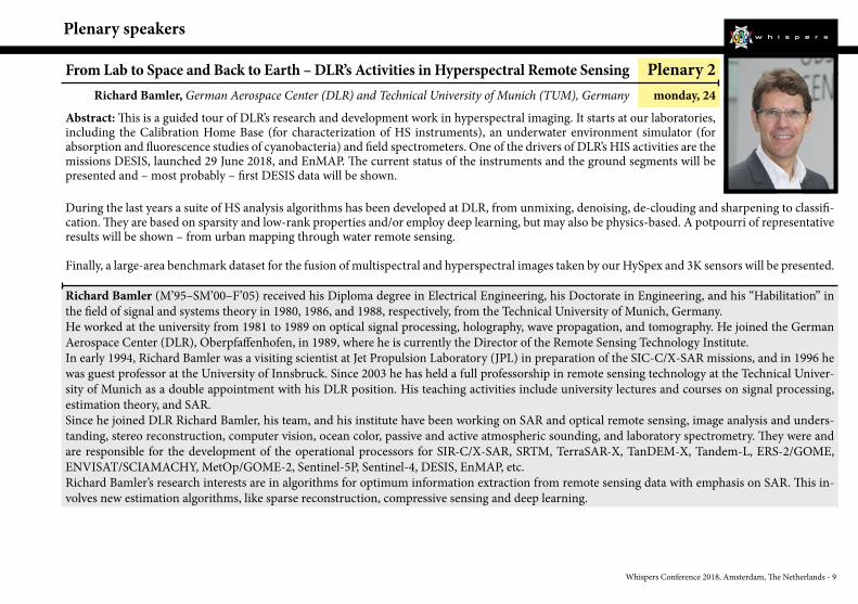
From Lab to Space and Back to Earth – DLR’s Activities in Hyperspectral Remote Sensing Plenary 2Richard Bamler, German Aerospace Center (DLR) and Technical University of Munich (TUM), Germany monday, 24
Abstract: This is a guided tour of DLR’s research and development work in hyperspectral imaging. It starts at our laboratories, including the Calibration Home Base (for characterization of HS instruments), an underwater environment simulator (for absorption and fluorescence studies of cyanobacteria) and field spectrometers. One of the drivers of DLR’s HIS activities are the missions DESIS, launched 29 June 2018, and EnMAP. The current status of the instruments and the ground segments will be presented and – most probably – first DESIS data will be shown. During the last years a suite of HS analysis algorithms has been developed at DLR, from unmixing, denoising, de-clouding and sharpening to classifi-cation. They are based on sparsity and low-rank properties and/or employ deep learning, but may also be physics-based. A potpourri of representative results will be shown – from urban mapping through water remote sensing. Finally, a large-area benchmark dataset for the fusion of multispectral and hyperspectral images taken by our HySpex and 3K sensors will be presented.
Richard Bamler (M’95–SM’00–F’05) received his Diploma degree in Electrical Engineering, his Doctorate in Engineering, and his “Habilitation” in the field of signal and systems theory in 1980, 1986, and 1988, respectively, from the Technical University of Munich, Germany.He worked at the university from 1981 to 1989 on optical signal processing, holography, wave propagation, and tomography. He joined the German Aerospace Center (DLR), Oberpfaffenhofen, in 1989, where he is currently the Director of the Remote Sensing Technology Institute.In early 1994, Richard Bamler was a visiting scientist at Jet Propulsion Laboratory (JPL) in preparation of the SIC-C/X-SAR missions, and in 1996 he was guest professor at the University of Innsbruck. Since 2003 he has held a full professorship in remote sensing technology at the Technical Univer-sity of Munich as a double appointment with his DLR position. His teaching activities include university lectures and courses on signal processing, estimation theory, and SAR.Since he joined DLR Richard Bamler, his team, and his institute have been working on SAR and optical remote sensing, image analysis and unders-tanding, stereo reconstruction, computer vision, ocean color, passive and active atmospheric sounding, and laboratory spectrometry. They were and are responsible for the development of the operational processors for SIR-C/X-SAR, SRTM, TerraSAR-X, TanDEM-X, Tandem-L, ERS-2/GOME, ENVISAT/SCIAMACHY, MetOp/GOME-2, Sentinel-5P, Sentinel-4, DESIS, EnMAP, etc.Richard Bamler’s research interests are in algorithms for optimum information extraction from remote sensing data with emphasis on SAR. This in-volves new estimation algorithms, like sparse reconstruction, compressive sensing and deep learning.

10 - Whispers Conference 2018, Amsterdam, The Netherlands
Plenary speakers
Plenary 3 Near Infrared Spectral Imaging: from the macro- to the micro-scale and beyondtuesday, 25 Aoife Gowen, UCD School of Biosystems and Food Engineering, Univ. College Dublin, Belfield, Dublin 4, IrelandAbstract: Spectral Imaging expands NIR spectroscopy into the spatial domain through acquisition of spatially contiguous spectra over a sample surface. This technique enables investigation of the spatial distribution of bio-chemical components on or within a sample. NIR spectral images can be obtained using different modalities, such as transmission, reflectance, transflec-tance or interactance, and at various spatial scales, with pixel sizes ranging in size from millimetres to microns. More recently, darkfield NIR spectral imaging has been developed for characterisation of NIR scattering spectra of nanometre sized objects, such as cells and nanoparticles. This flexibility has widened the scope for potential applications in the biosciences, for example
food quality analysis, pharmaceutical quality control, agricultural analysis and tissue characterisation. Regardless of the application, many common challenges are shared by practitioners of this technique, such as instrument selection, sample presentation and data analysis. These challenges are illus-trated here through the presentation of case studies from our laboratory, including: spatially registered macroscopic and microscopic characterisation of biomaterials; time series analysis of biopolymers to characterise their stability and interaction with water and darkfield NIR spectral imaging of tissue and cells to enhance knowledge of their microenvironment and response to various treatments.
Aoife Gowen is an Associate Professor in the UCD School of Biosystems and Food Engineering. Her research area is multidisciplinary, involving appli-cations of spectral imaging and chemometrics to biological systems, including foods, microbes and biomaterials. After completing her undergraduate degree in Theoretical Physics (2000), she moved to a new discipline – the highly applied research area of Food Science. Her PhD thesis, completed in 2006, concerned mathematical modeling of food quality parameters and optimization of food process operations. During her time as a post-doctoral researcher (2007-2013) she investigated the intersection of near infrared spectroscopy, chemical imaging and chemometrics for characterization of biological systems. She has been successful in gaining funding awards to support her research activities, including a European Union Marie Curie International Outgoing Fellowship and a European Research Council (ERC) starting grant. Further information on her research group can be found here: http://www.ucd.ie/sirg
Whispers Conference 2018, Amsterdam, The Netherlands - 11
Tutorials
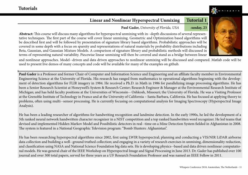
Linear and Nonlinear Hyperspectral Unmixing Tutorial 1Paul Gader, University of Florida, USA sunday, 23
Abstract: This course will discuss many algorithms for hyperspectral unmixing with in- ‐depth discussions of several represen-tative techniques. The first part of the course will cover linear unmixing. Geometric and Optimization based algorithms will be described first and will be followed by presentation of signature library based algorithms. Probabilistic approaches will be covered in some depth with a focus on sparsity and representations of natural materials by probability distributions including Beta, Gaussian, and Gaussian Mixture Models. A comparison of signature library and probabilistic methods will discussed in terms of representing natural variability. Piecewise linear unmixing will then be covered and stand as a bridge between linear and nonlinear approaches. Model- ‐driven and data driven approaches to nonlinear unmixing will be discussed and compared. Matlab code will be used to present live demos of many concepts and code will be available for many of the examples on github.
Paul Gader is a Professor and former Chair of Computer and Information Science and Engineering and an affiliate faculty member in Environmental Engineering Science at the University of Florida. His research has ranged from mathematics to operational algorithms beginning with the develop-ment of detection algorithms for FLIR imagery in 1984. He received a Ph.D. in Math in 1986 for parallelizing image processing algorithms. He has been a Senior Research Scientist at Honeywell’s System & Research Center; Research Engineer & Manager at the Environmental Research Institute of Michigan; and has held faculty positions at the Universities of Wisconsin- ‐ Oshkosh, Missouri; the University of Florida. He was a Visiting Professor at the Grenoble Institute of Technology in France and at the University of California – Santa Barbara, California. He has focused at applying theory to problems, often using multi- ‐sensor processing. He is currently focusing on computational analysis for Imaging Spectroscopy (Hyperspectral Image Analysis).
He has been a leading researcher of algorithms for handwriting recognition and landmine detection. In the early 1990s, he led the development of a 5th ranked neural network handwritten character recognizer in a NIST competition and a top ranked handwritten word recognizer. He led teams that devised and implemented Hidden Markov Model and Possibilistic detectors in real- ‐time on a Mine Detection System fielded in Afghanistan in 2008. The system is featured in a National Geographic Television program: “Bomb Hunters: Afghanistan”.
He has been researching hyperspectral algorithms since 2002, first using LWIR hyperspectral; planning and conducting a VIS/NIR LiDAR airborne data collection and building a well- ‐ground truthed collection; and engaging in a variety of research exercises in unmixing, dimensionality reduction, and classification using NASA and National Science Foundation big data sets. He is developing physics- ‐based and data driven nonlinear computatio-nal models. He was general chair of the IEEE Workshop on Hyperspectral Image and Signal Processing in June 2013. Dr. Gader has published over 100 journal and over 300 total papers, served for three years as a UF Research Foundation Professor and was named an IEEE Fellow in 2011.
12 - Whispers Conference 2018, Amsterdam, The Netherlands
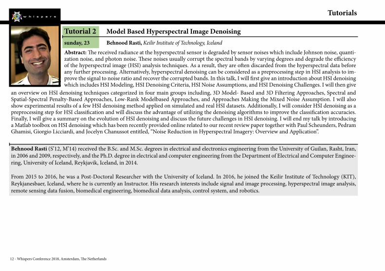
Tutorial 2 Model Based Hyperspectral Image Denoisingsunday, 23 Behnood Rasti, Keilir Institute of Technology, IcelandAbstract: The received radiance at the hyperspectral sensor is degraded by sensor noises which include Johnson noise, quanti-zation noise, and photon noise. These noises usually corrupt the spectral bands by varying degrees and degrade the efficiency of the hyperspectral image (HSI) analysis techniques. As a result, they are often discarded from the hyperspectral data before any further processing. Alternatively, hyperspectral denoising can be considered as a preprocessing step in HSI analysis to im-prove the signal to noise ratio and recover the corrupted bands. In this talk, I will first give an introduction about HSI denoising which includes HSI Modeling, HSI Denoising Criteria, HSI Noise Assumptions, and HSI Denoising Challenges. I will then give
an overview on HSI denoising techniques categorized in four main groups including, 3D Model- Based and 3D Filtering Approaches, Spectral and Spatial-Spectral Penalty-Based Approaches, Low-Rank Modelbased Approaches, and Approaches Making the Mixed Noise Assumption. I will also show experimental results of a few HSI denoising method applied on simulated and real HSI datasets. Additionally, I will consider HSI denoising as a preprocessing step for HSI classification and will discuss the advantage of utilizing the denoising algorithms to improve the classification accuracies. Finally, I will give a summary on the evolution of HSI denoising and discuss the future challenges in HSI denoising. I will end my talk by introducing a Matlab toolbox on HSI denoising which has been recently provided online related to our recent review paper together with Paul Scheunders, Pedram Ghamisi, Giorgio Licciardi, and Jocelyn Chanussot entitled, “Noise Reduction in Hyperspectral Imagery: Overview and Application”.
Behnood Rasti (S’12, M’14) received the B.Sc. and M.Sc. degrees in electrical and electronics engineering from the University of Guilan, Rasht, Iran, in 2006 and 2009, respectively, and the Ph.D. degree in electrical and computer engineering from the Department of Electrical and Computer Enginee-ring, University of Iceland, Reykjavik, Iceland, in 2014.
From 2015 to 2016, he was a Post-Doctoral Researcher with the University of Iceland. In 2016, he joined the Keilir Institute of Technology (KIT), Reykjanesbaer, Iceland, where he is currently an Instructor. His research interests include signal and image processing, hyperspectral image analysis, remote sensing data fusion, biomedical engineering, biomedical data analysis, control system, and robotics.
Tutorials
Whispers Conference 2018, Amsterdam, The Netherlands - 13
Tutorials
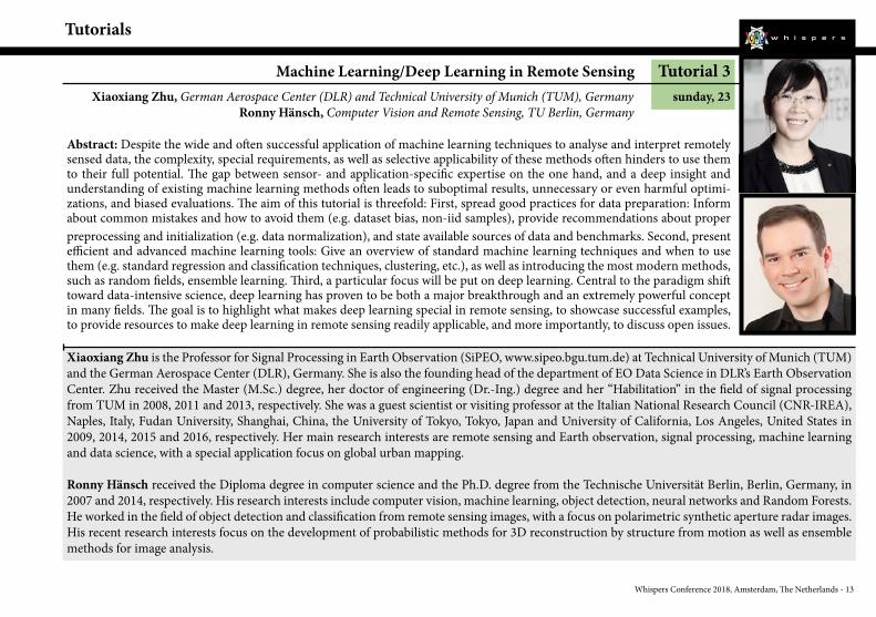
Machine Learning/Deep Learning in Remote Sensing Tutorial 3Xiaoxiang Zhu, German Aerospace Center (DLR) and Technical University of Munich (TUM), Germany sunday, 23
Ronny Hänsch, Computer Vision and Remote Sensing, TU Berlin, Germany
Abstract: Despite the wide and often successful application of machine learning techniques to analyse and interpret remotely sensed data, the complexity, special requirements, as well as selective applicability of these methods often hinders to use them to their full potential. The gap between sensor- and application-specific expertise on the one hand, and a deep insight and understanding of existing machine learning methods often leads to suboptimal results, unnecessary or even harmful optimi-zations, and biased evaluations. The aim of this tutorial is threefold: First, spread good practices for data preparation: Inform about common mistakes and how to avoid them (e.g. dataset bias, non-iid samples), provide recommendations about proper preprocessing and initialization (e.g. data normalization), and state available sources of data and benchmarks. Second, present efficient and advanced machine learning tools: Give an overview of standard machine learning techniques and when to use them (e.g. standard regression and classification techniques, clustering, etc.), as well as introducing the most modern methods, such as random fields, ensemble learning. Third, a particular focus will be put on deep learning. Central to the paradigm shift toward data-intensive science, deep learning has proven to be both a major breakthrough and an extremely powerful concept in many fields. The goal is to highlight what makes deep learning special in remote sensing, to showcase successful examples, to provide resources to make deep learning in remote sensing readily applicable, and more importantly, to discuss open issues.
Xiaoxiang Zhu is the Professor for Signal Processing in Earth Observation (SiPEO, www.sipeo.bgu.tum.de) at Technical University of Munich (TUM) and the German Aerospace Center (DLR), Germany. She is also the founding head of the department of EO Data Science in DLR’s Earth Observation Center. Zhu received the Master (M.Sc.) degree, her doctor of engineering (Dr.-Ing.) degree and her “Habilitation” in the field of signal processing from TUM in 2008, 2011 and 2013, respectively. She was a guest scientist or visiting professor at the Italian National Research Council (CNR-IREA), Naples, Italy, Fudan University, Shanghai, China, the University of Tokyo, Tokyo, Japan and University of California, Los Angeles, United States in 2009, 2014, 2015 and 2016, respectively. Her main research interests are remote sensing and Earth observation, signal processing, machine learning and data science, with a special application focus on global urban mapping.
Ronny Hänsch received the Diploma degree in computer science and the Ph.D. degree from the Technische Universität Berlin, Berlin, Germany, in 2007 and 2014, respectively. His research interests include computer vision, machine learning, object detection, neural networks and Random Forests. He worked in the field of object detection and classification from remote sensing images, with a focus on polarimetric synthetic aperture radar images. His recent research interests focus on the development of probabilistic methods for 3D reconstruction by structure from motion as well as ensemble methods for image analysis.
14 - Whispers Conference 2018, Amsterdam, The Netherlands
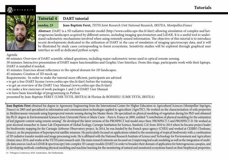
Tutorial 4 DART tutorialsunday, 23 Jean-Baptiste Feret, TETIS Joint Research Unit National Research, IRSTEA, Montpellier,FranceAbstract: DART is a 3D radiative transfer model (http://www.cesbio.ups-tlse.fr/dart) allowing simulation of complex and het-erogeneous landscapes acquired by different sensors, including imaging spectrometers and LiDAR. It is a useful tool to under-stand radiometric mechanisms involved when using remotely sensed information. The objective of this tutorial is to introduce recent developments dedicated to the utilization of DART in the case of simulation of imaging spectroscopy data, and it will be illustrated by study cases corresponding to forest ecosystems. Sensitivity studies will be explored through graphical user interface as well as dedicated python scripts.
Agenda60 minutes: Overview of DART scientific related questions, including major radiometric terms used in optical remote sensing.30 minutes: Interactive presentation of DART major functionalities and Graphic User Interface. From this stage, participants work with their laptops. DART is installed if needed.45 minutes: Exercises about reflectance in the optical domain for 2D landscapes.45 minutes: Creation of 3D mock-up.Requirements : In order to make the tutorial more efficient, participants are advised• to get a free DART license (www.cesbio.ups-tlse.fr/dart) before the training.• to get an overview of the DART User Manual (www.cesbio.ups-tlse.fr/dart)• to make a few exercises of work packages 1 and 2 of DART User Manual.• to have basic knowledge of programming in Pythonpresented by Jean-Baptiste FERET (UMR TETIS, IRSTEA) & Florian de BOISSIEU (UMR TETIS, IRSTEA)
Jean-Baptiste Féret obtained his degree in Agronomy Engineering from the International Center for Higher Education in Agricultural Sciences (Montpellier SupAgro, France) in 2005 and specialized in information and communication technologies applied to agriculture (AgroTIC). He worked on the characterization of soils properties in Mediterranean vineyards using hyperspectral remote sensing during his Master thesis. He specialized on physical modeling of vegetation during his PhD and obtained his Ph.D. degree in Environmental Sciences from Université Pierre et Marie Curie – Paris 6, France in 2009, entitled “Contribution of physical modeling for the estimation of leaf pigment content using remote sensing”. He developed the latest versions of the PROSPECT leaf model since then: PROSPECT-5 and PROSPECT-D. He worked as post-doctoral researcher in Asner Lab (Department of Global Ecology, Carnegie Institution for Science, Stanford, CA) from 2010 to 2014 where he became project leader for biodiversity mapping for the Carnegie Airborne Observatory project. In 2014, he was funded by the French space agency (CNES) and worked at CESBIO (Toulouse, France), on the preparation of hyperspectral satellite missions. He particularly focused on applications related to the monitoring of tropical biodiversity with a combination of 3D radiative transfer models and image processing tools. He is affiliated with the National Research Institute of Science and Technology for Environment and Agriculture (Irstea) since 2014, and works at the TETIS joint research unit. His main research interests are focused on i) improving leaf scale modeling as well as the integration of multi-ple data sources (such as LiDAR & spectroscopy) into complex 3D canopy models (DART) in order to broaden their domain of application for heterogeneous canopies, and ii) developing methods combining physical modeling and machine learning for the monitoring of natural and monitored ecosystems based on their biophysical properties.
Tutorials

Whispers Conference 2018, Amsterdam, The Netherlands - 15
WHISPERS at a glance
Monday, 24 Tuesday, 25 Wednesday, 26
Round Table
Coffee Break
Sunday, 23
8:30
All day poster session All day poster session All day poster session
wed-o-1-aRetrieval of
Water Parameters
Lunch
wed-o-1-bDeep
Learning (2)
12:00
wed-o-2-aThermal and
Infrared Sensing
wed-o-2-bMultidate Sensing
Coffee Break
wed-o-3-aClassification
wed-o-3-bGas and
Trace Gases
Plenary 1Jean-Baptiste Feret
Tutorials 1 - Paul Gader
2 - Behnood Rasti
3 - Xiaoxiang Zhu & Ronny Hänsch
4 - Jean-Baptiste Feret
Coffee Break
sun-o-1-aDeep
Learning (1)
sun-o-1-bCalibration New Sensor
Opening Ceremony
13:30
15:30
16:00
18:00
10:30
11:00
Plenary 3Aoife Gowen
Coffee Break
8:30
tue-o-1-aAnomaly
and Target Detection
Lunch
tue-o-1-bPrecision Farming
12:00
tue-o-2-aMulti-
modalityand
Data Fusion
tue-o-2-bHyper-spectral Imaging
from Small
Platforms(1)
Coffee Break
tue-o-3-aSpectral
Unmixing
tue-o-2-bHyper-spectral Imaging
from Small
Platforms(2)
13:30
15:30
16:00
18:00
9:30
10:00
Plenary 2Richard Bamler
Coffee Break
8:30
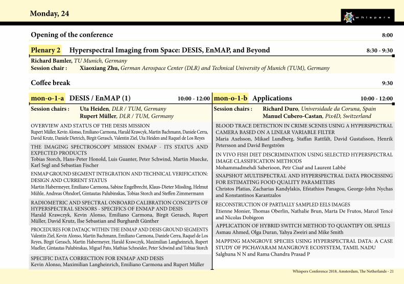
mon-o-1-aDESIS /
EnMAP (1)
Lunch
mon-o-1-bApplications
12:00
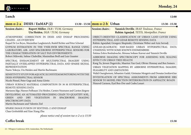
mon-o-2-aDESIS /
EnMAP (2)
mon-o-2-bUrban
Coffee Break
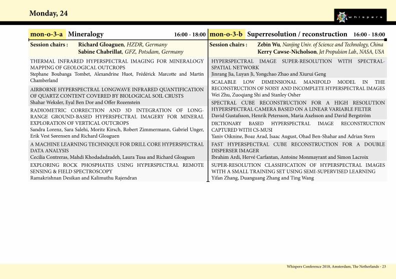
mon-o-3-aMineralogy
mon-o-3-bSuperresolution/Reconstruction
13:30
15:30
16:00
18:00
9:30
10:00
14:00
14:30
15:30
16:00
18:00
9:30
13:30
tue-o-3-cHyper-spectral sensing: end to end (2)
tue-o-2-cHyper-spectral sensing: end to end (1)
Sunday, 23
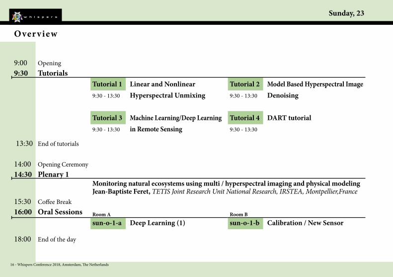
16 - Whispers Conference 2018, Amsterdam, The Netherlands
15:30 Coffee Break
Monitoring natural ecosystems using multi / hyperspectral imaging and physical modelingJean-Baptiste Feret, TETIS Joint Research Unit National Research, IRSTEA, Montpellier,France
sun-o-1-a Deep Learning (1) sun-o-1-b Calibration / New Sensor16:00 Oral Sessions
14:00 Opening Ceremony14:30 Plenary 1
9:00 Opening9:30 Tutorials
Over view
Room A Room B
Tutorial 1 Linear and Nonlinear 9:30 - 13:30 Hyperspectral Unmixing
Tutorial 2 Model Based Hyperspectral Image9:30 - 13:30 Denoising
18:00 End of the day
13:30 End of tutorials
Tutorial 3 Machine Learning/Deep Learning9:30 - 13:30 in Remote Sensing
Tutorial 4 DART tutorial9:30 - 13:30
Whispers Conference 2018, Amsterdam, The Netherlands - 17
Sunday, 23
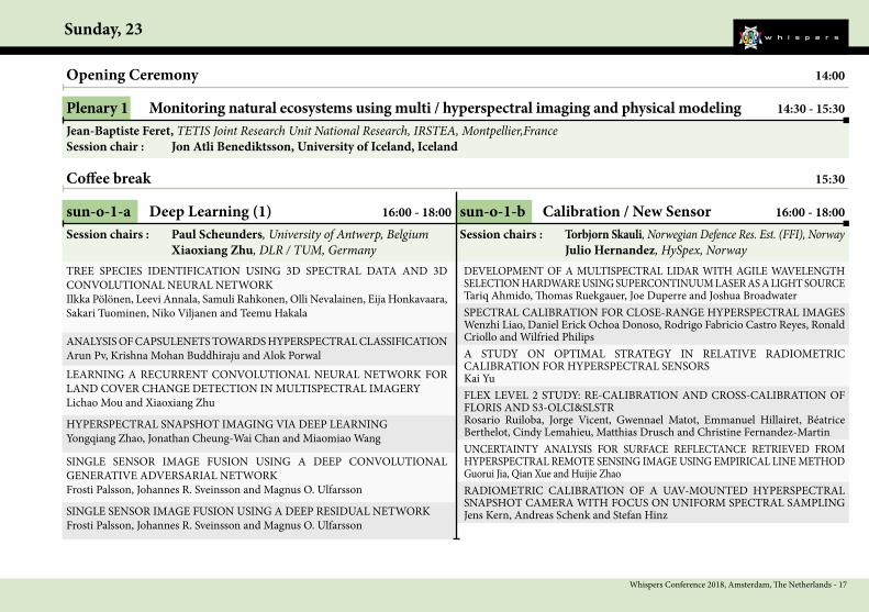
sun-o-1-a Deep Learning (1) 16:00 - 18:00
TREE SPECIES IDENTIFICATION USING 3D SPECTRAL DATA AND 3D CONVOLUTIONAL NEURAL NETWORKIlkka Pölönen, Leevi Annala, Samuli Rahkonen, Olli Nevalainen, Eija Honkavaara, Sakari Tuominen, Niko Viljanen and Teemu Hakala SPECTRAL CALIBRATION FOR CLOSE-RANGE HYPERSPECTRAL IMAGES
Wenzhi Liao, Daniel Erick Ochoa Donoso, Rodrigo Fabricio Castro Reyes, Ronald Criollo and Wilfried Philips
SINGLE SENSOR IMAGE FUSION USING A DEEP CONVOLUTIONAL GENERATIVE ADVERSARIAL NETWORK Frosti Palsson, Johannes R. Sveinsson and Magnus O. Ulfarsson
A STUDY ON OPTIMAL STRATEGY IN RELATIVE RADIOMETRIC CALIBRATION FOR HYPERSPECTRAL SENSORSKai Yu
Opening Ceremony 14:00
Plenary 1 Monitoring natural ecosystems using multi / hyperspectral imaging and physical modeling 14:30 - 15:30Jean-Baptiste Feret, TETIS Joint Research Unit National Research, IRSTEA, Montpellier,FranceSession chair : Jon Atli Benediktsson, University of Iceland, Iceland
Coffee break 15:30
sun-o-1-b Calibration / New Sensor 16:00 - 18:00Session chairs : Paul Scheunders, University of Antwerp, Belgium Xiaoxiang Zhu, DLR / TUM, Germany
FLEX LEVEL 2 STUDY: RE-CALIBRATION AND CROSS-CALIBRATION OF FLORIS AND S3-OLCI&SLSTRRosario Ruiloba, Jorge Vicent, Gwennael Matot, Emmanuel Hillairet, Béatrice Berthelot, Cindy Lemahieu, Matthias Drusch and Christine Fernandez-Martin
RADIOMETRIC CALIBRATION OF A UAV-MOUNTED HYPERSPECTRAL SNAPSHOT CAMERA WITH FOCUS ON UNIFORM SPECTRAL SAMPLING Jens Kern, Andreas Schenk and Stefan Hinz
LEARNING A RECURRENT CONVOLUTIONAL NEURAL NETWORK FOR LAND COVER CHANGE DETECTION IN MULTISPECTRAL IMAGERYLichao Mou and Xiaoxiang Zhu
HYPERSPECTRAL SNAPSHOT IMAGING VIA DEEP LEARNINGYongqiang Zhao, Jonathan Cheung-Wai Chan and Miaomiao Wang
SINGLE SENSOR IMAGE FUSION USING A DEEP RESIDUAL NETWORKFrosti Palsson, Johannes R. Sveinsson and Magnus O. Ulfarsson
Session chairs : Torbjorn Skauli, Norwegian Defence Res. Est. (FFI), Norway Julio Hernandez, HySpex, Norway
ANALYSIS OF CAPSULENETS TOWARDS HYPERSPECTRAL CLASSIFICATIONArun Pv, Krishna Mohan Buddhiraju and Alok Porwal
DEVELOPMENT OF A MULTISPECTRAL LIDAR WITH AGILE WAVELENGTH SELECTION HARDWARE USING SUPERCONTINUUM LASER AS A LIGHT SOURCETariq Ahmido, Thomas Ruekgauer, Joe Duperre and Joshua Broadwater
UNCERTAINTY ANALYSIS FOR SURFACE REFLECTANCE RETRIEVED FROM HYPERSPECTRAL REMOTE SENSING IMAGE USING EMPIRICAL LINE METHODGuorui Jia, Qian Xue and Huijie Zhao

Monday, 24
18 - Whispers Conference 2018, Amsterdam, The Netherlands
15:30 Coffee Break
Hyperspectral Imaging from Space: DESIS, EnMAP, and BeyondRichard Bamler, TU Munich, Germany
mon-o-3-a Mineralogy mon-o-3-b Superresolution / Reconstruction16:00 Oral Sessions
13:30 Oral Sessions
12:00 Lunch
10:00 Oral Sessions 9:30 Coffee Break
8:30 Plenary 2 8:00 Opening
All day Poster sessions
Room A Room B
mon-o-2-a DESIS / EnMAP (2) mon-o-2-b UrbanRoom A Room B
mon-o-1-a DESIS / EnMAP (1) mon-o-1-b ApplicationsRoom A Room B
mon-p-1 Mineralogymon-p-3 Software / Hardware
mon-p-2 Multimodality and Data Fusionmon-p-4 Classification
18:00 End of the day
Over view

Whispers Conference 2018, Amsterdam, The Netherlands - 19
Monday, 24
mon-p-1 Mineralogy All day poster session
mon-p-2 Multimodality and Data Fusion All day poster session
LASER-INDUCED FLUORESCENCE MAPPING: A NEW SPECTROSCOPIC TECHNIQUE FOR DETECTION OF RARE EARTH ELEMENTS IN ROCK SAMPLESPeter Seidel, Sandra Lorenz, Suchinder Sharma, Margret Fuchs, Jan Beyer, Johannes Heitmann and Richard GloaguenMAPPING HYDROTHERMAL ALTERATION MINERAL ASSEMBLAGES IN TUPPADUR-BUDDINNI BLOCK OF HUTTI-MASKI SCHIST BELT USING AIRBORNE HYPERSPECTRAL DATAAravind Bharathvaj, Kusuma K N, Lakshmi Ram Prasath H and Chaitanya Sandaka
EFFICACY OF HYPER-CORE-LOGGING IN URANIUM EXPLORATION: AN INVESTIGATION FROM KALADGI PROSPECT, INDIAKalimuthu Rajendran, Ramakrishnan Desikan and Hari Shankar Pandalai
MULTI-SOURCE HYPERSPECTRAL IMAGING OF CARBONATITE-HOST-ED REE-NB-TA MINERALIZATION AT MARINKAS QUELLEN, NAMIBIARené Booysen, Robert Zimmermann, Sandra Lorenz, Richard Gloaguen and Paul Nex
MAPPING THE VARIATION IN CHLORITE CHEMISTRY FOR LOCATING AURIFEROUS LODES IN THE BUDDINNI TUPPADUR REGION OF HUTTI-MASKI SCHIST BELT, INDIAKusuma K N, Aravind Bharathvaj S and Lakshmi Ram Prasath HMAPPING OF HISTORIC MINE TAILINGS AND ACID MINE DRAINAGE USING IN SITU HYPERSPECTRAL MEASUREMENTS AND WORLDVIEW 3 SATELLITE IMAGERYCorine Davids
LEARNING A COMMON SUBSPACE FROM HYPERSPECTRAL- MULTISPECTRAL CORRESPONDENCESDanfeng Hong, Naoto Yokoya, Xiao Xiang Zhu and Jocelyn ChanussotIMPROVING COREGISTRATION OF MULTIDATE AND MULTISENSOR ORCHARD IMAGERYStefan Livens, Stephanie Delalieux, Laurent Tits and Yasmin Vanbrabant
DON’T SETTLE FOR ANYTHING LESS: EXCELLENCY IN RESOLUTION, POSITION AND SIGNAL QUALITY IN COMBINED HYPERSPECTRAL IMAGERY AND LIDAR USING STATE-OF THE ART EQUIPMENT AND ADVANCED GEOREFERENCING TECHNIQUESDagrun Aarsten and Vetle O. Jonassen
MULTISPECTRAL LIDAR DATA FUSION VIA MULTIPLE KERNEL LEARNING FOR REMOTE SENSING CLASSIFICATIONYukun Wang and Yanfeng Gu
AN ALGORITHM OF REMOTELY SENSED HYPERSPECTRAL IMAGE FUSIONXuejian Sun, Lifu Zhang and Yi Cen
JOINT TENSOR SUBSPACE ALIGNMENT ON MULTI-ANGULAR REMOTE SENSING IMAGETianshuai Li and Yanfeng Gu
LASER-INDUCED FLUORESCENCE AND HYPERSPECTRAL IMAGING INTEGRATED IN ONE SENSOR SYSTEM - THE INSPECTOR PROJECTMargret Fuchs, Sandra Lorenz, Jan Beyer, Peter Seidel, Suchinder K. Sharma, Johannes Heitmann and Richard Gloaguen
HYPERSPECTRAL AND LIDAR FUSION USING DEEP THREE-STREAM CONVOLUTIONAL NEURAL NETWORKSHao Li, Pedram Ghamisi, Uwe Soergel and Xiao Xiang Zhu
RELATIVE AGE DATING OF HAWAIIAN LAVA FLOWS WITH AVIRIS AND HYTES HYPERSPECTRAL DATAMichael Abrams
IMAGE FUSION BASED ON GRADIENT REGULARIZED CONVOLUTION SPARSE REPRESENTIONJian Wang, Ping Ren, Ke Yang, Chunxia Qin and Xiufei ZhangIMAGE FUSION FOR HYPERSPECTRAL IMAGE SUPER-RESOLUTIONHasan Irmak, Gozde Bozdagi Akar and Seniha Esen YukselTREE SPECIES CLASSIFICATION BY FUSING OF VERY HIGHRESOLTUION HYPERSPECTRAL IMAGES AND 3K-DSMXiangtian Yuan, Jiaojiao Tian, Daniela Cerra, Oliver Meynberg, Christian Kempf and Peter ReinartzGRAPH REGULARIZED L1/2-SPARSITY CONSTRAINED NON-NEGATIVE MATRIX FACTORIZATION FOR HYPERSPECTRAL AND MULTISPECTRAL IMAGE FUSIONSevcan Kahraman, Alp Ertürk and Sarp Ertürk

Monday, 24
20 - Whispers Conference 2018, Amsterdam, The Netherlands
mon-p-4 Classification All day poster session
mon-p-3 Software / Hardware All day poster sessionAMIGO: A TOOL FOR THE GENERATION OF SYNTHETIC HYPERSPECTRAL IMAGESBlanca Priego and Richard DuroASSESSMENT OF THE RADIOMETRIC ACCURACY IN A TARGETLESS WORKFLOW USING PIX4D SOFTWAREManuel Cubero-Castan, Klaus Schneider-Zapp, Massimiliano Bellomo, Dai Shi, Martin Rehak and Christoph Strecha
A HARDWARE-FRIENDLY ALGORITHM FOR THE ON-BOARD COMPRESSION OF HYPERSPECTRAL IMAGESRaúl Guerra, María Díaz, Yubal Barrios, Sebastián López and Roberto SarmientoHARDWARE IMPLEMENTATION OF THE CCSDS 123.0-B-1 LOSSLESS MULTISPECTRAL AND HYPERSPECTRAL IMAGE COMPRESSION STANDARD BY MEANS OF HIGH LEVEL SYNTHESIS TOOLSYubal Barrios, Antonio Sánchez, Lucana Santos, José Fco. López and Roberto Sarmiento
CAPSULE NETWORK IN HYPERSPECTRAL CLASSIFICATIONGheorghe Gardu
RANDOMIZED NON NEGATIVE MATRIX FACTORIZATION FOR HYPERSPECTRAL IMAGE CLASSIFICATIONVineetha Menon and Qian Du
TWO-LEVEL FEATURE EXTRACTION FRAMEWORK FOR HYPERSPECTRAL IMAGE CLASSIFICATIONMunmun Baisantry, Anil Sao and Dericks Shukla
COMPOSITE KERNEL CLASSIFICATION USING SPECTRAL-SPATIAL FEATURES AND ABUNDANCE INFORMATION OF HYPERSPECTRAL IMAGEYanli Sun and Xia Zhang
A K-MEANS-GRAVITY-BASED CLUSTERING APPROACH FOR TERRAIN HYPERSPECTRAL IMAGERYHairong Tang and Xiurui GengCOMBINING CONTEXTUAL INFORMATION FOR SUBSPACE BASED HYPERSPECTRAL IMAGE CLASSIFICATIONShuyuan Xu and Jun Li
ITERATIVE ACTIVE LEARNING WITH DIFFUSION GEOMETRY FOR HYPERSPECTRAL IMAGESJames Murphy and Mauro Maggioni
RESEARCH AND APPLICATION OF SPARSE REPRESENTATION CLASSI-FICATION OF REMOTE SENSING IMAGERY BASED ON MULTI-FEATURE MODELINGLiu Yaoyao, Zhang Chunmei and Yang Kai
Whispers Conference 2018, Amsterdam, The Netherlands - 21
Monday, 24
mon-o-1-a DESIS / EnMAP (1) 10:00 - 12:00
OVERVIEW AND STATUS OF THE DESIS MISSIONRupert Müller, Kevin Alonso, Emiliano Carmona, Harald Krawcyk, Martin Bachmann, Daniele Cerra, David Krutz, Daniele Dietrich, Birgit Gerasch, Valentin Ziel, Uta Heiden and Raquel de Los ReyesTHE IMAGING SPECTROSCOPY MISSION ENMAP - ITS STATUS AND EXPECTED PRODUCTSTobias Storch, Hans-Peter Honold, Luis Guanter, Peter Schwind, Martin Muecke, Karl Segl and Sebastian Fischer
BLOOD TRACE DETECTION IN CRIME SCENES USING A HYPERSPECTRAL CAMERA BASED ON A LINEAR VARIABLE FILTERMaria Axelsson, Mikael Lundberg, Staffan Rattfält, David Gustafsson, Henrik Petersson and David Bergström
PROCEDURES FOR DATAQC WITHIN THE ENMAP AND DESIS GROUND SEGMENTSValentin Ziel, Kevin Alonso, Martin Bachmann, Emiliano Carmona, Daniele Cerra, Raquel de Los Reyes, Birgit Gerasch, Martin Habermeyer, Harald Krawczyk, Maximilian Langheinrich, Rupert Mueller, Gintautas Palubinskas, Miguel Pato, Mathias Schneider, Peter Schwind and Tobias Storch
IN VIVO FISH DIET DISCRIMINATION USING SELECTED HYPERSPECTRAL IMAGE CLASSIFICATION METHODSMohammadmehdi Saberioon, Petr Císař and Laurent LabbéSNAPSHOT MULTISPECTRAL AND HYPERSPECTRAL DATA PROCESSING FOR ESTIMATING FOOD QUALITY PARAMETERSChristos Platias, Zacharias Kandylakis, Efstathios Panagou, George-John Nychas and Konstantinos Karantzalos
Opening of the conference 8:00
Plenary 2 Hyperspectral Imaging from Space: DESIS, EnMAP, and Beyond 8:30 - 9:30Richard Bamler, TU Munich, GermanySession chair : Xiaoxiang Zhu, German Aerospace Center (DLR) and Technical University of Munich (TUM), Germany
Coffee break 9:30
mon-o-1-b Applications 10:00 - 12:00Session chairs : Uta Heiden, DLR / TUM, Germany Rupert Müller, DLR / TUM, Germany
RECONSTRUCTION OF PARTIALLY SAMPLED EELS IMAGESEtienne Monier, Thomas Oberlin, Nathalie Brun, Marta De Frutos, Marcel Tencé and Nicolas DobigeonAPPLICATION OF HYBRID SWITCH METHOD TO QUANTIFY OIL SPILLSAsmau Ahmed, Olga Duran, Yahya Zweiri and Mike SmithMAPPING MANGROVE SPECIES USING HYPERSPECTRAL DATA: A CASE STUDY OF PICHAVARAM MANGROVE ECOSYSTEM, TAMIL NADUSalghuna N N and Rama Chandra Prasad P
ENMAP GROUND SEGMENT INTEGRATION AND TECHNICAL VERIFICATION: DESIGN AND CURRENT STATUSMartin Habermeyer, Emiliano Carmona, Sabine Engelbrecht, Klaus-Dieter Missling, Helmut Mühle, Andreas Ohndorf, Gintautas Palubinskas, Tobias Storch and Steffen ZimmermannRADIOMETRIC AND SPECTRAL ONBOARD CALIBRATION CONCEPTS OF HYPERSPECTRAL SENSORS - SPECIFICS OF ENMAP AND DESISHarald Krawczyk, Kevin Alonso, Emiliano Carmona, Birgit Gerasch, Rupert Müller, David Krutz, Ilse Sebastian and Burghardt Günther
SPECIFIC DATA CORRECTION FOR ENMAP AND DESISKevin Alonso, Maximilian Langheinrich, Emiliano Carmona and Rupert Müller
Session chairs : Richard Duro, Universidade da Coruna, Spain Manuel Cubero-Castan, Pix4D, Switzerland
Monday, 24
22 - Whispers Conference 2018, Amsterdam, The Netherlands
mon-o-2-a DESIS / EnMAP (2) 13:30 - 15:50
ATMOSPHERIC CORRECTION IN DESIS AND ENMAP PROCESSING CHAINS - AN OVERVIEW Raquel De Los Reyes, Maximilian Langheinrich, Rudolf Richter and Peter SchwindGYPSUM ESTIMATION IN THE VNIR-SWIR SPECTRAL RANGE USING LABORATORY, AIR- AND SPACEBORNE HYPERSPECTRAL SENSORS FOR THE CHARACTERISATION OF SALT PAN ENVIRONMENTS Robert Milewski, Sabine Chabrillat, Maximilian Brell and Luis Guanter
OBJECT-ORIENTED CLASSIFICATION OF URBAN LAND COVER USING HYPERSPECTRAL AND LIDAR REMOTE SENSING DATARahim Aguejdad, Grzegorz Skupinski, Christiane Weber and Aziz SerradjLINEAR-QUADRATIC NMF-BASED URBAN HYPERSPECTRAL DATA UNMIXING WITH SOME KNOWN ENDMEMBERSFatima Zohra Benhalouche, Moussa Sofiane Karoui and Yannick DevilleAIRBORNE IMAGING SPECTROSCOPY FOR ASSESSING SOIL SEALING EFFECT ON URBAN TREE HEALTHKang Yu, Jeroen Degerickx, Maarten Van Geel, Olivier Honnay and Ben Somers
Lunch 12:00
mon-o-2-b Urban 13:30 - 15:30Session chairs : Rupert Müller, DLR / TUM, Germany Uta Heiden, DLR / TUM, Germany
URBAN VEGETATION MAPPING BY AIRBORNE HYPERSPETRAL IMAGERY; FEASABILITY AND LIMITATIONSWalid Ouerghemmi, Sébastien Gadal, Gintautas Mozgeris and Donatas Jonikavičius
SPECTRAL ENHANCEMENT OF MULTISPECTRAL IMAGERY USING PARTIALLY OVERLAPPED HYPERSPECTRAL DATA AND SPARSE SIGNAL REPRESENTATIONNaoto Yokoya, Uta Heiden and Martin BachmannSENSITIVITY STUDY FOR AQUATIC ECOSYSTEM MONITORING WITH THE DESIS HYPERSPECTRAL SENSORNicole Pinnel, Peter Gege and Anna Göritz
Session chairs : Yannick Deville, IRAP, Toulouse, France Rahim Aguejad, TETIS, Montpellier, France
Coffee break 15:30
INVESTIGATION OF SPECTRAL ASSIGNMENTS FROM AIRBORNE HRS SENSOR TO MODEL FRICTION DETERIORATION IN ASPHALTIC ROADSNimrod Carmon, Eyal Ben-Dor and Csaba LenartURBAN SURFACE MATERIAL COMPOSITION IN 30 M HYPERSPECTRAL
REMOTE SENSING DATAMarianne Jilge, Hannes Feilhauer, Uta Heiden, Carsten Neumann and Carsten JürgensDEVELOPING AN AUTOMATED PROCESSING CHAIN TO QUANTIFY SOIL, GREEN AND DRY VEGETATION IN SPACEBORNE IMAGING SPECTROSCOPY DATAMartin Bachmann and Valentin ZielSPARSE IMAGE FUSION OF SENTINEL-2 AND ENMAPClaas Grohnfeldt and Xiao Xiang Zhu
please notice end of session tue-o-2-a is 15:50
Whispers Conference 2018, Amsterdam, The Netherlands - 23
Monday, 24
mon-o-3-a Mineralogy 16:00 - 18:00
THERMAL INFRARED HYPERSPECTRAL IMAGING FOR MINERALOGY MAPPING OF GEOLOGICAL OUTCROPSStephane Boubanga Tombet, Alexandrine Huot, Frédérick Marcotte and Martin ChamberlandAIRBORNE HYPERSPECTRAL LONGWAVE INFRARED QUANTIFICATION OF QUARTZ CONTENT COVERED BY BIOLOGICAL SOIL CRUSTS Shahar Weksler, Eyal Ben Dor and Offer Rozenstein
HYPERSPECTRAL IMAGE SUPER-RESOLUTION WITH SPECTRAL- SPATIAL NETWORKJinrang Jia, Luyan Ji, Yongchao Zhao and Xiurui Geng
EXPLORING ROCK PHOSPHATES USING HYPERSPECTRAL REMOTE SENSING & FIELD SPECTROSCOPYRamakrishnan Desikan and Kalimuthu Rajendran
SCALABLE LOW DIMENSIONAL MANIFOLD MODEL IN THE RECONSTRUCTION OF NOISY AND INCOMPLETE HYPERSPECTRAL IMAGESWei Zhu, Zuoqiang Shi and Stanley OsherSPECTRAL CUBE RECONSTRUCTION FOR A HIGH RESOLUTION HYPERSPECTRAL CAMERA BASED ON A LINEAR VARIABLE FILTERDavid Gustafsson, Henrik Petersson, Maria Axelsson and David Bergström
mon-o-3-b Superresolution / reconstruction 16:00 - 18:00Session chairs : Richard Gloaguen, HZDR, Germany Sabine Chabrillat, GFZ, Potsdam, Germany
DICTIONARY BASED HYPERSPECTRAL IMAGE RECONSTRUCTION CAPTURED WITH CS-MUSIYaniv Oiknine, Boaz Arad, Isaac August, Ohad Ben-Shahar and Adrian SternFAST HYPERSPECTRAL CUBE RECONSTRUCTION FOR A DOUBLE DISPERSER IMAGERIbrahim Ardi, Hervé Carfantan, Antoine Monmayrant and Simon LacroixSUPER-RESOLUTION CLASSIFICATION OF HYPERSPECTRAL IMAGES WITH A SMALL TRAINING SET USING SEMI-SUPERVISED LEARNINGYifan Zhang, Duanguang Zhang and Ting Wang
RADIOMETRIC CORRECTION AND 3D INTEGRATION OF LONG-RANGE GROUND-BASED HYPERSPECTRAL IMAGERY FOR MINERAL EXPLORATION OF VERTICAL OUTCROPSSandra Lorenz, Sara Salehi, Moritz Kirsch, Robert Zimmermann, Gabriel Unger, Erik Vest Sørensen and Richard GloaguenA MACHINE LEARNING TECHNIQUE FOR DRILL CORE HYPERSPECTRAL DATA ANALYSISCecilia Contreras, Mahdi Khodadadzadeh, Laura Tusa and Richard Gloaguen
Session chairs : Zebin Wu, Nanjing Univ. of Science and Technology, China Kerry Cawse-Nicholson, Jet Propulsion Lab., NASA, USA

Tuesday, 25
24 - Whispers Conference 2018, Amsterdam, The Netherlands
15:30 Coffee Break
Near Infrared Spectral Imaging: from the macro- to the micro-scale and beyondAoife Gowen, University College Dublin, Ireland
tue-o-3-a Spectral Unmixing tue-o-3-b Hyperspectral Imaging from Small Platforms (2)
16:00 Oral Sessions
13:30 Oral Sessions
12:00 Lunch
10:00 Oral Sessions 9:30 Coffee Break
8:30 Plenary 3 8:00 Opening
All day Poster sessions
Room A Room B
tue-o-2-a Multimodality and Data Fusion tue-o-2-b Hyperspectral Imaging from Small Platforms (1)
Room A Room B
tue-o-1-a Anomaly and Target Detection tue-o-1-b Precision FarmingRoom A Room B
tue-p-1 Vegetation / Forestry / Soiltue-p-3 Anomaly and Target Detection
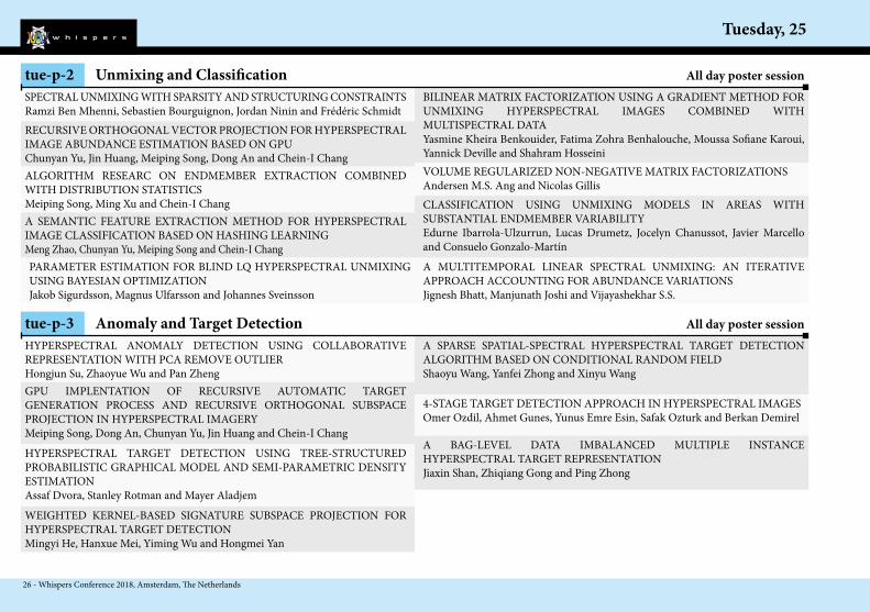
tue-p-2 Unmixing and Classification
18:00 End of the day
tue-o-2-c Hyperspectral sensing: end to end (1)
tue-o-3-c Hyperspectral sensing: end to end (2)
Room C
Room C
Over view

Whispers Conference 2018, Amsterdam, The Netherlands - 25
Tuesday, 25
tue-p-1 Vegetation / Forestry / Soil All day poster sessionA COMPARISON BETWEEN SENTINEL 2 AND AIRBORNE HYPERSPECTRAL DATA FOR SOIL ORGANIC CARBON PREDICTION IN CROPLANDSFabio Castaldi, Sabine Chabrillat, Kathrin Ward and Bas van WesemaelMAPPING CROP VARIABILITY RELATED TO SOIL QUALITY AND CROP STRESS WITHIN RAINFED ME DITERRANEAN AGROECOSYSTEMS USING HYPERSPECTRAL DATASabine Chabrillat, Thomas Schmid, Robert Milewski, Paula Escribano, Monica Garcia, Eyal Ben-Dor, Stephane Guillaso, Marta Pelayo, Andres Reyes, Veronica Sobejano-Paz and Marcos Jiménez Michavila
TRACKING HEATWAVE EFFECTS ON VEGETATION PRODUCTIVITY USING SOLAR-INDUCED CHLOROPHYLL FLUORESCENCELifu Zhang, Na Qiao, Changping Huang and Siheng Wang
PLANT FUNCTIONAL TYPES VS. OPTICAL TYPES: DO SPECTRAL CLUSTERS OF HERBACEOUS SPECIES CAPTURE FUNCTIONAL TRAIT VARIATION ?Elisa Van Cleemput, Hannes Feilhauer, Kenny Helsen, Olivier Honnay and Ben Somers
A SEMI-SUPERVISED ALGORITHM TO MAP MAJOR VEGETATION ZONES USING SATELLITE HYPERSPECTRAL DATAMevan Ekanayake, Hasantha Ekanayake, Anusha Rathnayake, Sajani Vithana, Vijitha Herath, Roshan Godaliyadda and Parakrama EkanayakeBANDS SELECTION BASED ON GENETIC ALGORITHM FOR SPECIES VEGETATION DISCRIMINATIONAbdelilah El Amraoui, Abbass Rammal, Eric Perrin and Valeriu Vrabie
A REAL-WORLD HYPERSPECTRAL IMAGE PROCESSING PIPELINE FOR VEGETATION AND HYDROCARBON CHARACTERIZATIONNicolas Audebert, Alexandre Alakian, Véronique Achard, Philippe Déliot, Sophie Fabre, Bertrand Le Saux, Anthony Crédoz, Dominique Dubucq, Cédric Taillandier and Sébastien LefèvreCLUSTERING FOREST TYPES BY MEANS OF REMOTELY-SENSED PHENOLOGY: ITALY AS A CASE STUDYSofia Bajocco, Carlotta Ferrara, Alessandro Alivernini, Marco Bascietto and Carlo Ricotta
DEVELOPMENT OF HARMONIZED SOIL SPECTRAL LIBRARIES: ASSESSMENT OF THE INFLUENCE OF DIFFERENT LABORATORY SET-UPS AND HUMIDITY CONDITIONSSabine Chabrillat, Asa Gholizadeh, Carsten Neumann, Daniel Berger, Robert Milewski, Yaron Ogen and Eyal Ben Dor
DISCRIMINATION OF TREE SPECIES BASED ON THEIR SPECTRA COLLECTED AT SPATIO-TEMPORAL SCALE IN THE FOREST OF ARAKU, EASTERN GHATS, INDIA.Salghuna N N, Rama Chandra Prasad P and Rama Rao N
NORMAL DIRECTION AND TRUE COLOR ESTIMATION OF LEAVES BASED ON TENSOR DECOMPOSITION OF LEAF-SCALE OPTICAL IMAGESKuniaki Uto, Mauro Dalla Mura and Jocelyn Chanussot
USING MULTI-DIMENSIONAL DATASET (MDD) FOR APPLICATION OF REMOTE SENSING TIME SERIES: A CASE STUDY IN FOREST DISTURBANCESLifu Zhang, Yukun Lin and Nan Wang
OPTIMIZED PROCESSING OF AIRBORNE HYPERSPECTRAL DATA FOR FOREST STUDIESStefanie Holzwarth, Nicole Pinnel, Martin Bachmann, Mathias Schneider, Claas Köhler, Andreas Baumgartner and Daniel Schläpfer
FUSION OF HYPERSPECTRAL IMAGES AND LIDAR DATA FOR FORESTRY MONITORING - A REVIEWEduardo Tusa, Anthony Laybros, Jean-Matthieu Monnet, Mauro Dalla Mura, Jean-Baptiste Barré, Michele Dalponte, Jean-Baptiste Féret, Grégoire Vincent and Jocelyn Chanussot
Tuesday, 25
26 - Whispers Conference 2018, Amsterdam, The Netherlands
tue-p-3 Anomaly and Target Detection All day poster session
tue-p-2 Unmixing and Classification All day poster sessionSPECTRAL UNMIXING WITH SPARSITY AND STRUCTURING CONSTRAINTSRamzi Ben Mhenni, Sebastien Bourguignon, Jordan Ninin and Frédéric SchmidtRECURSIVE ORTHOGONAL VECTOR PROJECTION FOR HYPERSPECTRAL IMAGE ABUNDANCE ESTIMATION BASED ON GPUChunyan Yu, Jin Huang, Meiping Song, Dong An and Chein-I Chang
BILINEAR MATRIX FACTORIZATION USING A GRADIENT METHOD FOR UNMIXING HYPERSPECTRAL IMAGES COMBINED WITH MULTISPECTRAL DATAYasmine Kheira Benkouider, Fatima Zohra Benhalouche, Moussa Sofiane Karoui, Yannick Deville and Shahram HosseiniVOLUME REGULARIZED NON-NEGATIVE MATRIX FACTORIZATIONSAndersen M.S. Ang and Nicolas Gillis
HYPERSPECTRAL ANOMALY DETECTION USING COLLABORATIVE REPRESENTATION WITH PCA REMOVE OUTLIERHongjun Su, Zhaoyue Wu and Pan ZhengGPU IMPLENTATION OF RECURSIVE AUTOMATIC TARGET GENERATION PROCESS AND RECURSIVE ORTHOGONAL SUBSPACE PROJECTION IN HYPERSPECTRAL IMAGERYMeiping Song, Dong An, Chunyan Yu, Jin Huang and Chein-I Chang
A SPARSE SPATIAL-SPECTRAL HYPERSPECTRAL TARGET DETECTION ALGORITHM BASED ON CONDITIONAL RANDOM FIELDShaoyu Wang, Yanfei Zhong and Xinyu Wang
HYPERSPECTRAL TARGET DETECTION USING TREE-STRUCTURED PROBABILISTIC GRAPHICAL MODEL AND SEMI-PARAMETRIC DENSITY ESTIMATIONAssaf Dvora, Stanley Rotman and Mayer Aladjem
4-STAGE TARGET DETECTION APPROACH IN HYPERSPECTRAL IMAGESOmer Ozdil, Ahmet Gunes, Yunus Emre Esin, Safak Ozturk and Berkan Demirel
A BAG-LEVEL DATA IMBALANCED MULTIPLE INSTANCE HYPERSPECTRAL TARGET REPRESENTATIONJiaxin Shan, Zhiqiang Gong and Ping Zhong
ALGORITHM RESEARC ON ENDMEMBER EXTRACTION COMBINED WITH DISTRIBUTION STATISTICSMeiping Song, Ming Xu and Chein-I Chang CLASSIFICATION USING UNMIXING MODELS IN AREAS WITH
SUBSTANTIAL ENDMEMBER VARIABILITYEdurne Ibarrola-Ulzurrun, Lucas Drumetz, Jocelyn Chanussot, Javier Marcello and Consuelo Gonzalo-Martín
A SEMANTIC FEATURE EXTRACTION METHOD FOR HYPERSPECTRAL IMAGE CLASSIFICATION BASED ON HASHING LEARNINGMeng Zhao, Chunyan Yu, Meiping Song and Chein-I Chang
WEIGHTED KERNEL-BASED SIGNATURE SUBSPACE PROJECTION FOR HYPERSPECTRAL TARGET DETECTIONMingyi He, Hanxue Mei, Yiming Wu and Hongmei Yan
A MULTITEMPORAL LINEAR SPECTRAL UNMIXING: AN ITERATIVE APPROACH ACCOUNTING FOR ABUNDANCE VARIATIONSJignesh Bhatt, Manjunath Joshi and Vijayashekhar S.S.
PARAMETER ESTIMATION FOR BLIND LQ HYPERSPECTRAL UNMIXING USING BAYESIAN OPTIMIZATIONJakob Sigurdsson, Magnus Ulfarsson and Johannes Sveinsson
Whispers Conference 2018, Amsterdam, The Netherlands - 27
Tuesday, 25
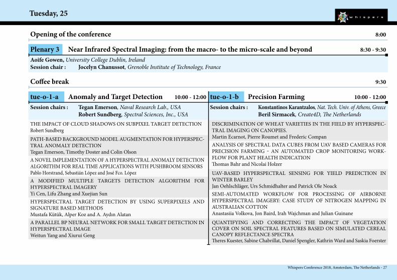
tue-o-1-a Anomaly and Target Detection 10:00 - 12:00
THE IMPACT OF CLOUD SHADOWS ON SUBPIXEL TARGET DETECTIONRobert SundbergPATH-BASED BACKGROUND MODEL AUGMENTATION FOR HYPERSPEC-TRAL ANOMALY DETECTIONTegan Emerson, Timothy Doster and Colin Olson
DISCRIMINATION OF WHEAT VARIETIES IN THE FIELD BY HYPERSPEC-TRAL IMAGING ON CANOPIES.Martin Ecarnot, Pierre Roumet and Frederic Compan
HYPERSPECTRAL TARGET DETECTION BY USING SUPERPIXELS AND SIGNATURE BASED METHODS Mustafa Kütük, Alper Koz and A. Aydın Alatan
ANALYSIS OF SPECTRAL DATA CUBES FROM UAV BASED CAMERAS FOR PRECISION FARMING ‒ AN AUTOMATED CROP MONITORING WORK-FLOW FOR PLANT HEALTH INDICATIONThomas Bahr and Nicolai Holzer
Opening of the conference 8:00
Plenary 3 Near Infrared Spectral Imaging: from the macro- to the micro-scale and beyond 8:30 - 9:30Aoife Gowen, University College Dublin, IrelandSession chair : Jocelyn Chanussot, Grenoble Institute of Technology, France
Coffee break 9:30
tue-o-1-b Precision Farming 10:00 - 12:00Session chairs : Tegan Emerson, Naval Research Lab., USA Robert Sundberg, Spectral Sciences, Inc., USA
UAV-BASED HYPERSPECTRAL SENSING FOR YIELD PREDICTION IN WINTER BARLEYJan Oehlschläger, Urs Schmidhalter and Patrick Ole NoackSEMI-AUTOMATED WORKFLOW FOR PROCESSING OF AIRBORNE HYPERSPECTRAL IMAGERY: CASE STUDY OF NITROGEN MAPPING IN AUSTRALIAN COTTONAnastasiia Volkova, Jon Baird, Irah Wajchman and Julian GuinaneQUANTIFYING AND CORRECTING THE IMPACT OF VEGETATION COVER ON SOIL SPECTRAL FEATURES BASED ON SIMULATED CEREAL CANOPY REFLECTANCE SPECTRATheres Kuester, Sabine Chabrillat, Daniel Spengler, Kathrin Ward and Saskia Foerster
A NOVEL IMPLEMENTATION OF A HYPERSPECTRAL ANOMALY DETECTION ALGORITHM FOR REAL TIME APPLICATIONS WITH PUSHBROOM SENSORSPablo Horstrand, Sebastián López and José Fco. LópezA MODIFIED MULTIPLE TARGETS DETECTION ALGORITHM FOR HYPERSPECTRAL IMAGERYYi Cen, Lifu Zhang and Xuejian Sun
A PARALLEL BP NEURAL NETWORK FOR SMALL TARGET DETECTION IN HYPERSPECTRAL IMAGEWeitun Yang and Xiurui Geng
Session chairs : Konstantinos Karantzalos, Nat. Tech. Univ. of Athens, Greece Beril Sirmacek, Create4D, The Netherlands
Tuesday, 25
28 - Whispers Conference 2018, Amsterdam, The Netherlands
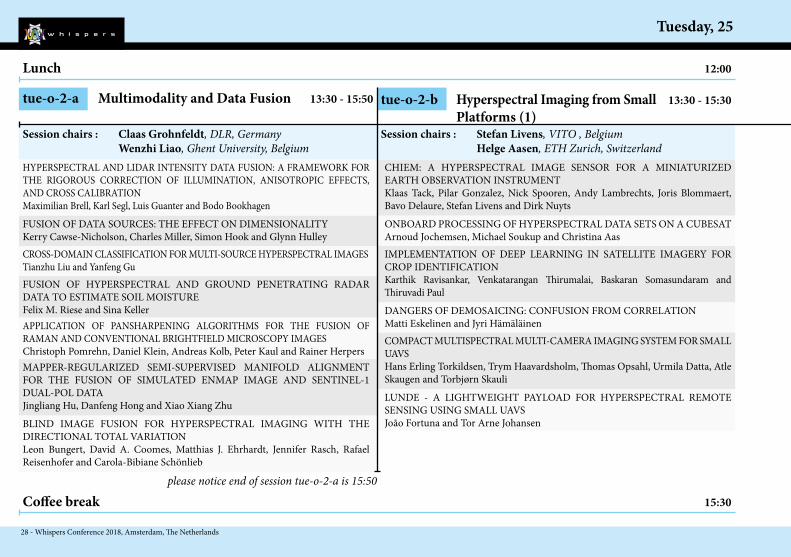
tue-o-2-a Multimodality and Data Fusion 13:30 - 15:50
HYPERSPECTRAL AND LIDAR INTENSITY DATA FUSION: A FRAMEWORK FOR THE RIGOROUS CORRECTION OF ILLUMINATION, ANISOTROPIC EFFECTS, AND CROSS CALIBRATIONMaximilian Brell, Karl Segl, Luis Guanter and Bodo BookhagenFUSION OF DATA SOURCES: THE EFFECT ON DIMENSIONALITYKerry Cawse-Nicholson, Charles Miller, Simon Hook and Glynn Hulley
CHIEM: A HYPERSPECTRAL IMAGE SENSOR FOR A MINIATURIZED EARTH OBSERVATION INSTRUMENTKlaas Tack, Pilar Gonzalez, Nick Spooren, Andy Lambrechts, Joris Blommaert, Bavo Delaure, Stefan Livens and Dirk NuytsONBOARD PROCESSING OF HYPERSPECTRAL DATA SETS ON A CUBESATArnoud Jochemsen, Michael Soukup and Christina AasIMPLEMENTATION OF DEEP LEARNING IN SATELLITE IMAGERY FOR CROP IDENTIFICATIONKarthik Ravisankar, Venkatarangan Thirumalai, Baskaran Somasundaram and Thiruvadi Paul
Lunch 12:00
tue-o-2-b Hyperspectral Imaging from Small 13:30 - 15:30 Platforms (1)
Session chairs : Claas Grohnfeldt, DLR, Germany Wenzhi Liao, Ghent University, Belgium
DANGERS OF DEMOSAICING: CONFUSION FROM CORRELATIONMatti Eskelinen and Jyri Hämäläinen
CROSS-DOMAIN CLASSIFICATION FOR MULTI-SOURCE HYPERSPECTRAL IMAGESTianzhu Liu and Yanfeng GuFUSION OF HYPERSPECTRAL AND GROUND PENETRATING RADAR DATA TO ESTIMATE SOIL MOISTUREFelix M. Riese and Sina Keller
Session chairs : Stefan Livens, VITO , Belgium Helge Aasen, ETH Zurich, Switzerland
Coffee break 15:30
COMPACT MULTISPECTRAL MULTI-CAMERA IMAGING SYSTEM FOR SMALL UAVSHans Erling Torkildsen, Trym Haavardsholm, Thomas Opsahl, Urmila Datta, Atle Skaugen and Torbjørn SkauliLUNDE - A LIGHTWEIGHT PAYLOAD FOR HYPERSPECTRAL REMOTE SENSING USING SMALL UAVSJoão Fortuna and Tor Arne Johansen
APPLICATION OF PANSHARPENING ALGORITHMS FOR THE FUSION OF RAMAN AND CONVENTIONAL BRIGHTFIELD MICROSCOPY IMAGESChristoph Pomrehn, Daniel Klein, Andreas Kolb, Peter Kaul and Rainer HerpersMAPPER-REGULARIZED SEMI-SUPERVISED MANIFOLD ALIGNMENT FOR THE FUSION OF SIMULATED ENMAP IMAGE AND SENTINEL-1 DUAL-POL DATAJingliang Hu, Danfeng Hong and Xiao Xiang ZhuBLIND IMAGE FUSION FOR HYPERSPECTRAL IMAGING WITH THE DIRECTIONAL TOTAL VARIATIONLeon Bungert, David A. Coomes, Matthias J. Ehrhardt, Jennifer Rasch, Rafael Reisenhofer and Carola-Bibiane Schönlieb
please notice end of session tue-o-2-a is 15:50

Whispers Conference 2018, Amsterdam, The Netherlands - 29
Tuesday, 25
OPTIMAL ESTIMATION FOR IMAGING SPECTROMETER ATMOSPHERIC CORRECTIONDavid Ray Thompson, Elizabeth Middleton, Vijay Natraj, Robert Green, Mark Helmlinger, Bo-Cai Gao and Michael Eastwood3D AND SNAPSHOT HYPERSPECTRAL CAMERAS BASED ON CONTINUOUSLY VARIABLE FILTERSOliver Pust and Henrik FabriciusA SPECTRAL IMAGING SYSTEM, INTEGRATING THERMAL, SWIR AND HYPERSPECTRAL SENSORS, FOR THE EFFICIENT MONITORING AND SURVEILLANCE OF WIDEZONESZacharias Kandylakis, Konstantinos Karantzalos, Lazaros Karagiannidis, Fay Misichroni and Angelos AmditisQUANTITATIVE REMOTE SENSING AT ULTRA-HIGH RESOLUTION WITH UAV SPECTROSCOPY: A REVIEW OF SENSOR TECHNOLOGY, MEASUREMENT PRO-CEDURES, AND DATA CORRECTION WORKFLOWSHelge Aasen, Eija Honkavaara, Arko Lucieer and Pablo J. Zarco-Tejada
Session chairs : Simon Hook, Jet Propulsion Laboratory, NASA, USA Theres Küster, GFZ, Potsdam, Germany
tue-o-2-c Hyperspectral sensing: end to end (1) 13:30 - 15:30
Coffee break 15:30
Lunch 12:00
Tuesday, 25
30 - Whispers Conference 2018, Amsterdam, The Netherlands
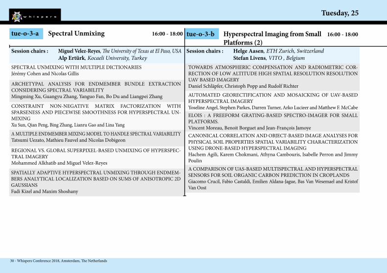
tue-o-3-a Spectral Unmixing 16:00 - 18:00
SPECTRAL UNMIXING WITH MULTIPLE DICTIONARIESJérémy Cohen and Nicolas Gillis
ARCHETYPAL ANALYSIS FOR ENDMEMBER BUNDLE EXTRACTION CONSIDERING SPECTRAL VARIABILITYMingming Xu, Guangyu Zhang, Yanguo Fan, Bo Du and Liangpei Zhang
TOWARDS ATMOSPHERIC COMPENSATION AND RADIOMETRIC COR-RECTION OF LOW ALTITUDE HIGH SPATIAL RESOLUTION RESOLUTION UAV BASED IMAGERYDaniel Schläpfer, Christoph Popp and Rudolf Richter
REGIONAL VS. GLOBAL SUPERPIXEL-BASED UNMIXING OF HYPERSPEC-TRAL IMAGERYMohammed Alkhatib and Miguel Velez-Reyes
AUTOMATED GEORECTIFICATION AND MOSAICKING OF UAV-BASED HYPERSPECTRAL IMAGERYYoseline Angel, Stephen Parkes, Darren Turner, Arko Lucieer and Matthew F. McCabe
tue-o-3-b Hyperspectral Imaging from Small 16:00 - 18:00 Platforms (2)
Session chairs : Miguel Velez-Reyes, The University of Texas at El Paso, USA Alp Ertürk, Kocaeli University, Turkey
ELOIS : A FREEFORM GRATING-BASED SPECTRO-IMAGER FOR SMALL PLATFORMS.Vincent Moreau, Benoit Borguet and Jean-François JamoyeCANONICAL CORRELATION AND OBJECT-BASED IMAGE ANALYSES FOR PHYSICAL SOIL PROPERTIES SPATIAL VARIABILITY CHARACTERIZATION USING DRONE-BASED HYPERSPECTRAL IMAGINGHachem Agili, Karem Chokmani, Athyna Cambouris, Isabelle Perron and Jimmy PoulinA COMPARISON OF UAS-BASED MULTISPECTRAL AND HYPERSPECTRAL SENSORS FOR SOIL ORGANIC CARBON PREDICTION IN CROPLANDSGiacomo Crucil, Fabio Castaldi, Emilien Aldana-Jague, Bas Van Wesemael and Kristof Van Oost
CONSTRAINT NON-NEGATIVE MATRIX FACTORIZATION WITH SPARSENESS AND PIECEWISE SMOOTHNESS FOR HYPERSPECTRAL UN-MIXINGXu Sun, Qian Peng, Bing Zhang, Lianru Gao and Lina YangA MULTIPLE ENDMEMBER MIXING MODEL TO HANDLE SPECTRAL VARIABILITYTatsumi Uezato, Mathieu Fauvel and Nicolas Dobigeon
Session chairs : Helge Aasen, ETH Zurich, Switzerland Stefan Livens, VITO , Belgium
SPATIALLY ADAPTIVE HYPERSPECTRAL UNMIXING THROUGH ENDMEM-BERS ANALYTICAL LOCALIZATION BASED ON SUMS OF ANISOTROPIC 2D GAUSSIANSFadi Kizel and Maxim Shoshany
Whispers Conference 2018, Amsterdam, The Netherlands - 31
Tuesday, 25
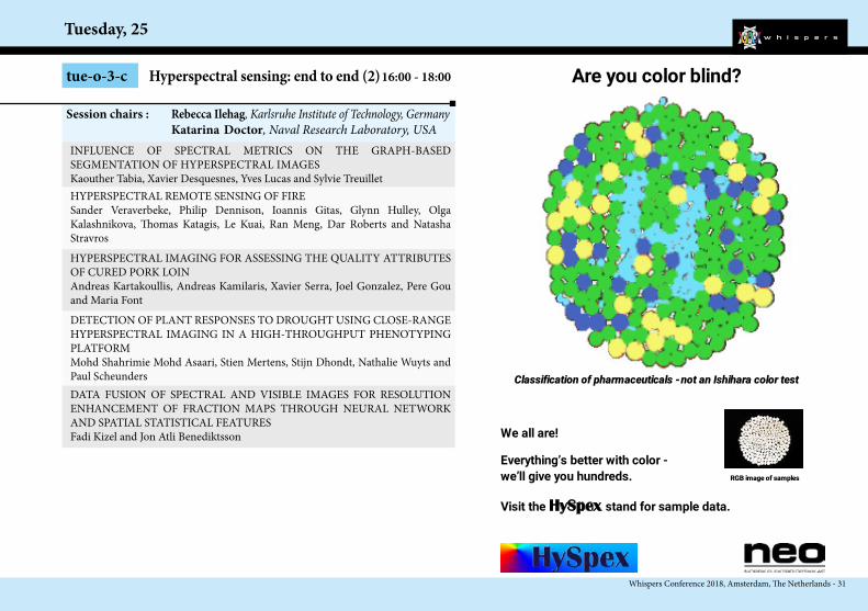
INFLUENCE OF SPECTRAL METRICS ON THE GRAPH-BASED SEGMENTATION OF HYPERSPECTRAL IMAGESKaouther Tabia, Xavier Desquesnes, Yves Lucas and Sylvie TreuilletHYPERSPECTRAL REMOTE SENSING OF FIRESander Veraverbeke, Philip Dennison, Ioannis Gitas, Glynn Hulley, Olga Kalashnikova, Thomas Katagis, Le Kuai, Ran Meng, Dar Roberts and Natasha StravrosHYPERSPECTRAL IMAGING FOR ASSESSING THE QUALITY ATTRIBUTES OF CURED PORK LOINAndreas Kartakoullis, Andreas Kamilaris, Xavier Serra, Joel Gonzalez, Pere Gou and Maria Font
tue-o-3-c Hyperspectral sensing: end to end (2) 16:00 - 18:00
DETECTION OF PLANT RESPONSES TO DROUGHT USING CLOSE-RANGE HYPERSPECTRAL IMAGING IN A HIGH-THROUGHPUT PHENOTYPING PLATFORMMohd Shahrimie Mohd Asaari, Stien Mertens, Stijn Dhondt, Nathalie Wuyts and Paul ScheundersDATA FUSION OF SPECTRAL AND VISIBLE IMAGES FOR RESOLUTION ENHANCEMENT OF FRACTION MAPS THROUGH NEURAL NETWORK AND SPATIAL STATISTICAL FEATURESFadi Kizel and Jon Atli Benediktsson
Session chairs : Rebecca Ilehag, Karlsruhe Institute of Technology, Germany Katarina Doctor, Naval Research Laboratory, USA
Are you color blind?
Classification of pharmaceuticals - not an Ishihara color test
We all are!
Everything’s better with color - we’ll give you hundreds. RGB image of samples
Visit the HySpex stand for sample data.

Wednesday, 26
32 - Whispers Conference 2018, Amsterdam, The Netherlands
15:30 Coffee Break
wed-o-3-a Classification wed-o-3-b Gas and Trace Gases16:00 Oral Sessions
13:30 Oral Sessions
12:00 Lunch
8:30 Oral Sessions
10:30 Coffee Break11:00 Round table
8:00 Opening
All day Poster sessions
Room A Room B
wed-o-2-a Thermal and Infrared Sensing wed-o-2-b Multidate SensingRoom A Room B
wed-o-1-a Retrieval of Water Parameters wed-o-1-b Deep Learning (2)Room A Room B
wed-p-1 Thermal and Infrared Sensingwed-p-3 Applications
wed-p-2 Sensors / Missionswed-p-4 Noise
18:00 End of the day
Over view
Whispers Conference 2018, Amsterdam, The Netherlands - 33
Wednesday, 26
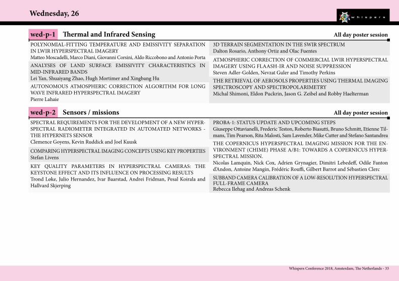
wed-p-1 Thermal and Infrared Sensing All day poster sessionPOLYNOMIAL-FITTING TEMPERATURE AND EMISSIVITY SEPARATION IN LWIR HYPERSPECTRAL IMAGERYMatteo Moscadelli, Marco Diani, Giovanni Corsini, Aldo Riccobono and Antonio PortaANALYSES OF LAND SURFACE EMISSIVITY CHARACTERISTICS IN MID-INFRARED BANDSLei Yan, Shuaiyang Zhao, Hugh Mortimer and Xingbang Hu
3D TERRAIN SEGMENTATION IN THE SWIR SPECTRUMDalton Rosario, Anthony Ortiz and Olac Fuentes
AUTONOMOUS ATMOSPHERIC CORRECTION ALGORITHM FOR LONG WAVE INFRARED HYPERSPECTRAL IMAGERYPierre Lahaie
ATMOSPHERIC CORRECTION OF COMMERCIAL LWIR HYPERSPECTRAL IMAGERY USING FLAASH-IR AND NOISE SUPPRESSIONSteven Adler-Golden, Nevzat Guler and Timothy PerkinsTHE RETRIEVAL OF AEROSOLS PROPERTIES USING THERMAL IMAGING SPECTROSCOPY AND SPECTROPOLARIMETRYMichal Shimoni, Eldon Puckrin, Jason G. Zeibel and Robby Haelterman
wed-p-2 Sensors / missions All day poster sessionSPECTRAL REQUIREMENTS FOR THE DEVELOPMENT OF A NEW HYPER-SPECTRAL RADIOMETER INTEGRATED IN AUTOMATED NETWORKS - THE HYPERNETS SENSORClemence Goyens, Kevin Ruddick and Joel KuuskCOMPARING HYPERSPECTRAL IMAGING CONCEPTS USING KEY PROPERTIESStefan Livens
PROBA-1: STATUS UPDATE AND UPCOMING STEPSGiuseppe Ottavianelli, Frederic Teston, Roberto Biasutti, Bruno Schmitt, Etienne Til-mans, Tim Pearson, Rita Malosti, Sam Lavender, Mike Cutter and Stefano Santandrea
KEY QUALITY PARAMETERS IN HYPERSPECTRAL CAMERAS: THE KEYSTONE EFFECT AND ITS INFLUENCE ON PROCESSING RESULTSTrond Løke, Julio Hernandez, Ivar Baarstad, Andrei Fridman, Pesal Koirala and Hallvard Skjerping
THE COPERNICUS HYPERSPECTRAL IMAGING MISSION FOR THE EN-VIRONMENT (CHIME) PHASE A/B1: TOWARDS A COPERNICUS HYPER-SPECTRAL MISSION.Nicolas Lamquin, Nick Cox, Adrien Grynagier, Dimitri Lebedeff, Odile Fanton d’Andon, Antoine Mangin, Frédéric Rouffi, Gilbert Barrot and Sébastien ClercSUBBAND CAMERA CALIBRATION OF A LOW-RESOLUTION HYPERSPECTRAL FULL-FRAME CAMERARebecca Ilehag and Andreas Schenk
Wednesday, 26
34 - Whispers Conference 2018, Amsterdam, The Netherlands
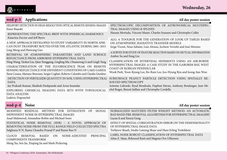
wed-p-3 Applications All day poster sessionHELIPORT DETECTION IN HIGH-RESOLUTION OPTICAL REMOTE SENSING IMAGESEmre Başeski
SPECTROSCOPIC DECOMPOSITION OF ASTRONOMICAL MULTISPEC-TRAL IMAGES USING B-SPLINESHassan Mortada, Vincent Mazet, Charles Soussen and Christophe Collet
ALG: A TOOLBOX FOR THE GENERATION OF LOOK-UP TABLES BASED ON ATMOSPHERIC RADIATIVE TRANSFER MODELSJorge Vicent, Neus Sabater, Luis Alonso, Jochem Verrelst and José Moreno
CLASSIFICATION OF INTERTIDAL SEDIMENTS USING AN AIR-BORNE HYPERSPECTRAL IMAGES: A CASE STUDY IN THE GARORIM BAY, WEST COAST OF KOREAN PENINSULARWook Park, Yoon-Kyung Lee, Bo-Ram Lee, Joo-Hyung Ryu and Joong-Sun Won
A NEW APPROACH DEVELOPED TO STUDY VARIABILITY IN NORTH AFRI-CAN DUST TRANSPORT ROUTES OVER THE ATLANTIC DURING 2001–2015Ling Meng and Huiwang GaoRETRIEVAL OF ATMOSPHERIC PARAMETERS AND LAND SURFACE REFLECTANCE FROM AIRBORNE HYPERSPECTRAL DATANing Wang, Yaokai Liu, Qian Yonggang, Lingling Ma, Chuanrong Li and Lingli Tang
A SURVEY FOR STUDY OF FEATURE SELECTION BASED ON MUTUAL INFORMATIONAmber Su and Fang Liu
CHARACTERIZATION OF THE FLUORESCENCE PEAK ON REMOTE SENSING REFLECTANCE FOR DIFFERENT CONDITIONS OF LAKE GARDAIlaria Cesana, Mariano Bresciani, Sergio Cogliati, Roberto Colombo and Claudia Giardino
REPRESENTING THE SPECTRAL BRDF WITH SPHERICAL HARMONICSKatarina Doctor and Jeff Byers
wed-p-4 Noise All day poster sessionMODIFIED RESIDUAL METHOD FOR ESTIMATION OF SIGNAL DEPENDENT NOISE IN HYPERSPECTRAL IMAGESAsad Mahmood, Amandine Robin and Michael SearsSTATISTICAL NOISE REMOVAL (SNR) – A NOVEL APPROACH OF REMOVING NOISE FROM THE FULL RANGE FIELD COLLECTED SPECTRASalghuna N N, Rama Chandra Prasad P and Rama Rao N
NORMALIZED MATCHED FILTER WEIGHT METHOD: AN AUTOMATIC BAD BAND PRE-REMOVAL ALGORITHM FOR HYPERSPECTRAL IMAGERYLuyan Ji and Xiurui Geng
CLOUD REMOVAL BASED ON NOISE-ADJUSTED PRINCIPAL COMPONENTS TRANSFORMMeng Xu, Sen Jia, Xiuping Jia and Mark Pickering
EFFECT OF SPATIAL COREGISTRATION ERROR ON THE DIMENSIONALITY OF HYPERSPECTRAL IMAGE DATATorbjorn Skauli, Sindre Løining Skaar and Hans Erling Torkildsen
SUBSURFACE PEANUT PARTICLE DETECTION USING SPATIALLY RE-SOLVED SPECTROSCOPYAntoine Laborde, Ryad Bendoula, Daphné Heran, Anthony Boulanger, Jean Mi-chel Roger, Benoit Jaillais and Christophe Cordella
DETECTION OF FERTILIZER QUANTITY IN SOIL USING HYPERSPECTRAL DATAJay Prakash Kumar, Shailesh Deshpande and Arun Inamdar
EXPLORING CHEMICAL IMAGING DATA SETS WITH TOPOLOGICAL DATA ANALYSISLudovic Duponchel
LABEL NOISE ROBUST CLASSIFICATION OF HYPERSPECTRAL DATAAlina E. Maas, Behnood Rasti and Magnus Orn Ulfarsson

Whispers Conference 2018, Amsterdam, The Netherlands - 35
Wednesday, 26
wed-o-1-a Retrieval of Water Parameters 8:30 - 10:30
WATERHYPERNET - A NETWORK OF HYPERSPECTRAL RADIOMETERS FOR MULTI-SATELLITE WATER REFLECTANCE VALIDATIONKevin Ruddick, Dieter Vansteenwegen, Matthew Beck, David Doxaran, Ana Dogliotti, Fang Shen, Dimitry Van der Zande, Thanos Gkritzalis and André CattrijssePROCESSING OF CHRIS-PROBA HYPERSPECTRAL IMAGES TO RETRIEVE WATER QUALITY INFORMATIONHeloise Lavigne, Quinten Vanhellemont and Kevin Ruddick
DIMENSIONALITY-VARIED CONVOLUTIONAL NEURAL NETWORK FOR HYPERSPECTRAL IMAGE CLASSIFICATION WITH SMALL-SIZED LABELED SAMPLESXuejian Liang, Wanjun Liu, Ye Zhang and Jie Yu
MACHINE LEARNING REGRESSION ON HYPERSPECTRAL DATA TO ESTIMATE MULTIPLE WATER PARAMETERSPhilipp M. Maier and Sina Keller
HYPERSPECTRAL IMAGE CLASSIFICATION VIA SAMPLE EXPANSION FOR CONVOLUTIONAL NEURAL NETWORKJiaojiao Li, Qian Du, Bobo Xi and Yunsong Li
Opening of the conference 8:00
Round Table 11:00 - 12:00
Coffee break 10:30
wed-o-1-b Deep Learning (2) 8:30 - 10:30
Session chairs : Ivar Erdal, Ecotone, Norway Mireille Guillaume, Inst. Fresnel, Marseille, France
A DIVERSIFIED DEEP ENSEMBLE FOR HYPERSPECTRAL IMAGE CLASSIFICATIONZhiqiang Gong, Ping Zhong, Jiaxin Shan and Weidong HuTRIPLET CONSTRAINED DEEP FEATURE EXTRACTION FOR HYPERSPECTRAL IMAGE CLASSIFICATIONFahim Alam, Jun Zhou, Alan Wee-Chung Liew, Jun Jo and Yongsheng GaoTRANSFERING SUPER RESOLUTION CONVOLUTIONAL NEURAL NETWORK FOR REMOTE SENSING DATA SHARPENINGMeziane Iftene, Mohammed El Amin Arabi and Moussa Sofiane Karoui
EFFECT OF INCLUSION OF NEW VARIABLES IN INVERSION OF SEMI – ANALYTICAL MODEL FOR SYNTHETIC HYPERSPECTRAL DATA OF SHALLOW WATERSSrinivas Kolluru, Shirishkumar S Gedam and Inamdar A B
Session chairs : Yanfeng Xu, Harbin Insitute of Technology, China Yang Xu, Nanjing Univ. of Science and Technology, China
NMF HYPERSPECTRAL UNMIXING OF THE SEA BOTTOM: INFLUENCE OF THE ADJACENCY EFFECTS, MODEL AND METHODMireille Guillaume, Louis Juste, Xavier Lenot, Yannick Deville, Bruno Lafrance, Malik Chami, Sylvain Jay, Audrey Minghelli, Xavier Briottet and Veronique Serfaty
Wednesday, 26
36 - Whispers Conference 2018, Amsterdam, The Netherlands
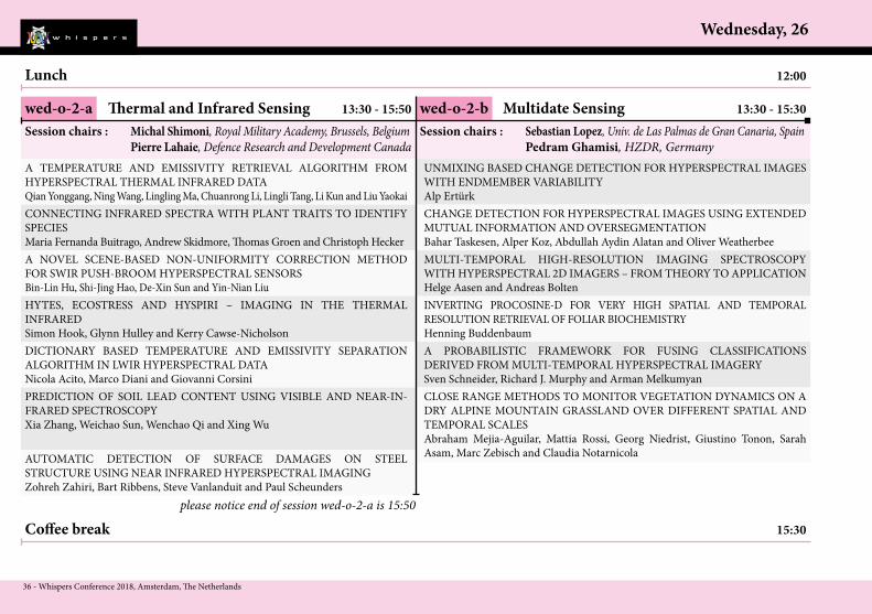
wed-o-2-a Thermal and Infrared Sensing 13:30 - 15:50
A TEMPERATURE AND EMISSIVITY RETRIEVAL ALGORITHM FROM HYPERSPECTRAL THERMAL INFRARED DATAQian Yonggang, Ning Wang, Lingling Ma, Chuanrong Li, Lingli Tang, Li Kun and Liu YaokaiCONNECTING INFRARED SPECTRA WITH PLANT TRAITS TO IDENTIFY SPECIESMaria Fernanda Buitrago, Andrew Skidmore, Thomas Groen and Christoph Hecker
UNMIXING BASED CHANGE DETECTION FOR HYPERSPECTRAL IMAGES WITH ENDMEMBER VARIABILITYAlp ErtürkCHANGE DETECTION FOR HYPERSPECTRAL IMAGES USING EXTENDED MUTUAL INFORMATION AND OVERSEGMENTATIONBahar Taskesen, Alper Koz, Abdullah Aydin Alatan and Oliver WeatherbeeMULTI-TEMPORAL HIGH-RESOLUTION IMAGING SPECTROSCOPY WITH HYPERSPECTRAL 2D IMAGERS – FROM THEORY TO APPLICATIONHelge Aasen and Andreas Bolten
Lunch 12:00
wed-o-2-b Multidate Sensing 13:30 - 15:30Session chairs : Michal Shimoni, Royal Military Academy, Brussels, Belgium Pierre Lahaie, Defence Research and Development Canada
INVERTING PROCOSINE-D FOR VERY HIGH SPATIAL AND TEMPORAL RESOLUTION RETRIEVAL OF FOLIAR BIOCHEMISTRYHenning Buddenbaum
A NOVEL SCENE-BASED NON-UNIFORMITY CORRECTION METHOD FOR SWIR PUSH-BROOM HYPERSPECTRAL SENSORSBin-Lin Hu, Shi-Jing Hao, De-Xin Sun and Yin-Nian LiuHYTES, ECOSTRESS AND HYSPIRI – IMAGING IN THE THERMAL INFRAREDSimon Hook, Glynn Hulley and Kerry Cawse-Nicholson
Session chairs : Sebastian Lopez, Univ. de Las Palmas de Gran Canaria, Spain Pedram Ghamisi, HZDR, Germany
Coffee break 15:30
A PROBABILISTIC FRAMEWORK FOR FUSING CLASSIFICATIONS DERIVED FROM MULTI-TEMPORAL HYPERSPECTRAL IMAGERYSven Schneider, Richard J. Murphy and Arman MelkumyanCLOSE RANGE METHODS TO MONITOR VEGETATION DYNAMICS ON A DRY ALPINE MOUNTAIN GRASSLAND OVER DIFFERENT SPATIAL AND TEMPORAL SCALESAbraham Mejia-Aguilar, Mattia Rossi, Georg Niedrist, Giustino Tonon, Sarah Asam, Marc Zebisch and Claudia Notarnicola
DICTIONARY BASED TEMPERATURE AND EMISSIVITY SEPARATION ALGORITHM IN LWIR HYPERSPECTRAL DATANicola Acito, Marco Diani and Giovanni CorsiniPREDICTION OF SOIL LEAD CONTENT USING VISIBLE AND NEAR-IN-FRARED SPECTROSCOPYXia Zhang, Weichao Sun, Wenchao Qi and Xing Wu
AUTOMATIC DETECTION OF SURFACE DAMAGES ON STEEL STRUCTURE USING NEAR INFRARED HYPERSPECTRAL IMAGINGZohreh Zahiri, Bart Ribbens, Steve Vanlanduit and Paul Scheunders
please notice end of session wed-o-2-a is 15:50

Whispers Conference 2018, Amsterdam, The Netherlands - 37
Wednesday, 26
wed-o-3-a Classification 16:00 - 18:00
A SPECTRAL–SPATIAL INFORMATION INTEGRATED-KERNEL MINIMUM NOISE FRACTION TRANSFORMATION FOR HYPERSPECTRAL IMAGE CLASSIFICATIONBin Zhao, Lianru Gao and Bing ZhangHYPERSPECTRAL IMAGE CLASSIFICATION BASED ON EXTENDED MOR-PHOLOGICAL ATTRIBUTE PROFILES AND ABUNDANCE INFORMATIONXia Zhang, Yanli Sun and Wenchao Qi
HIGH SPATIAL RESOLUTION IMAGING OF METHANE AND OTHER TRACE GASES WITH THE AIRBORNE HYPERSPECTRAL THERMAL EMISSION SPECTROMETER (HYTES)Glynn Hulley
ORTHOGONAL POLYNOMIAL FUNCTION FITTING FOR HYPERSPECTRAL DATA REPRESENTATION AND DISCRIMINATIONLiwei Li, Bing Zhang and Lianru Gao
GAS PLUME DETECTION IN HYPERSPECTRAL VIDEO SEQUENCE USING TENSOR NUCLEAR NORMWenting Shang, Zebin Wu, Jie Wei, Yang Xu, Ling Qian, Zhihui Wei, Jocelyn Chanussot and Andrea BertozziA NOVEL HIGHLY PARALLEL ALGORITHM FOR THE DETECTION AND TRACKING OF CHEMICAL GAS PLUMES USING HYPERSPECTRAL VIDEO SEQUENCESMaria Diaz, Jocelyn Chanussot, Raul Guerra, SebastiÁn LÓpez, Roberto Sarmiento and Andrea L. Bertozzi
wed-o-3-b Gas and Trace Gases 16:00 - 18:00Session chairs : Qian Du, Mississippi State University, USA Shailesh Deshpande, Tata Consultancy Services Ltd, India
IMPORTANCE OF BAND SELECTION FOR ETHENE AND METHANOL GAS DETECTION IN HYPERSPECTRAL IMAGERYSafak Ozturk, Yunus Emre Esin, Yusuf Artan, Omer Ozdil and Berkan DemirelA NOVEL 2-STAGE APPROACH FOR CO2 GAS DETECTION USING HYPERSPECTRAL IMAGERYSafak Ozturk, Yusuf Artan, Yunus Emre Esin and Omer Ozdil
KERNEL SPATIAL-SPECTRAL BASED MULTI-VIEW LOW-RANK SPARSE SUBSPACE CLUSTERING FOR HYPERSPECTRAL IMAGERYLong Tian, Qian Du, Ivica Kopriva and Nicolas Younan
A NOVEL DERIVATIVE-BASED CLASSIFICATION METHOD FOR HYPER-SPECTRAL DATA PROCESSINGYücel Çimtay and Hakkı Gökhan İlk
Session chairs : Glynn Hulley, Jet Propulsion Laboratory, NASA, USA Safak Ozturk, Havelsan, Turkey
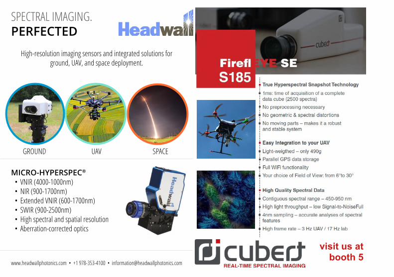
visit us at booth 5
SPECTRAL IMAGING.PERFECTED
High-resolution imaging sensors and integrated solutions for ground, UAV, and space deployment.
GROUND UAV SPACE
MICRO-HYPERSPEC®
• VNIR (4000-1000nm)• NIR (900-1700nm)• Extended VNIR (600-1700nm)• SWIR (900-2500nm)• High spectral and spatial resolution• Aberration-corrected optics
www.headwallphotonics.com • +1 978-353-4100 • [email protected]

Pix4D is the commercial leader in photogrammetry software.
Meet Pix4D
We are physicists, computer scientists, photogrammetrists, drone enthusiasts, geospatial experts, and engineers— inspired to transform business through computer vision, machine learning, and photogrammetry. We break boundaries. We design, prototype, build, test, and iterate. At the heart of everything we do is our unrelenting drive to evolve and improve. It fuels our creativity. It is how we solve problems. It’s the reason we love getting up in the morning and coming to work—and it’s why we’re so successful. Our roots are in academia and research and developing transformational software. Our passion is contagious. Our people are the best. Sounds like fun?
We are hiring!pix4d.com/jobs
www.pix4d.commeet us at booth 7

TOGETHER WE CAN MAKE LIGHT TALK!
SOFTWAREFOR SPECTRAL DATA MANAGEMENT
AND PROCESSING
JSI JOURNAL OF SPECTRAL IMAGING
An Open Access Journal from IMP Open
impopen.com/jsi
Join the JSI JourneyPublish in JSI—Journal of Spectral Imaging and benefit from:
■ Constructive peer review led by an experienced Editorial Team
■ Rapid publication (Letters published within three weeks)
■ Personal approach from an experienced, niche publisher
■ Wide dissemination of your work, including indexing in Scopus, DOAJ etc.
■ No publication fees (for a limited period)
Find out why you should be publishing in JSI:
Delta Optical Thin Film designs, manufactures, tests and supplies world class leading optical thin film filters and components. Our products are used in a variety of applications within the medical, bioscience, imaging, sensor, analytical and similar industries and are designed and manufactured according to ISO 9001 and ISO 1400 standards.
High quality products are the keystone of Delta Optical Thin Film’s success. Our quality management system ensures control and documentation of processes and products throughout the whole design and production process.
Located in Hørsholm, Denmark, Delta Optical Thin Film has since the 1960s been the pioneer in computer designed optical coatings.
In the early 1990s, Delta Optical Thin Film was among the first to implement computer controlled and automatic deposition of advanced optical coatings.
Our development team is able to make extremely precise predictions of, for example, phase retardation, and uses other dedicated techniques, helping the world’s leading manufacturers of analytical and biomedical instruments make unique instruments.
We Are The Optical Filter Company.
meet us at booth 11

www.imec-int.com/hyperspectral-imaging
CMOS BASED HYPERSPECTRAL IMAGING SOLUTIONS
Application feasibility studies Full system HW and SW solutions Custom modules for OEM integration
VISIT US AT BOOTH 23 FOR A LIVE DEMO

www.malvernpanalytical.com/ASD
YOUR SOURCE FOR ASD SPECTROMETERS
Meet us at booth 24!
Geosense is a reputable independent geological remote sen-sing consultancy that has gained global recognition for its top-quality remote sensing services. Over the last 30 year we have built up a unique experience in the use of satellite, air-borne and ground based remote sensing technology and in-terpretations for the mining and mineral exploration business.
Our services include:• Spectral analysis, Alteration Mapping and Target
Generation. Specialists in Epithermal, Mesothermal, Porphyry, IOCG and Lateritic mineralization
• Geological Mapping, focused on Structure and Stratigraphy
• Hyperspectral analysis• Fieldwork: spectroscopic ground-truthing and altera-
tion mapping• Structural analysis and terrain analysis• Spectroscopic core-logging• Processing of optical imagery such as Landsat, Aster,
Sentinel-2, Ikonos, Quickbird, GeoEye and World-View-3
• Custom made Colour Composites, Ortho-images, Digital Elevation Models, topographic basemaps etc.
• Environmental mapping and vegetation monitoring
http://www.geosense.nl
GEOSENSE
Visit us at booth 12 !

SpectroExpo / WHISPERS - 33 rue Thiers, Grenoble, France
www.SpectroExpo.com
GreenTr pism perClass
HyT CHImaging
SPECTRO EXPO
S c i e n c e . Te c h n o l o g y . A p p l i c a t i o n s
JSI JOURNAL OF SPECTRAL IMAGING
An Open Access Journal from IMP Open
SPECTROSCOPYSPECTROSCOPYThe essential magazine for spectroscopists in Europe
europeeurope