9. World Heritage properties and National Heritage placeseisdocs.dsdip.qld.gov.au/Lower Fitzroy...
12
i 41/20736/449156 Draft environmental impact statement June 2015 Volume 2 Chapter 9 World Heritage properties and National Heritage places 9. World Heritage properties and National Heritage places Table of contents 9. World Heritage properties and National Heritage places................................................... i 9.1 Overview........................................................................................................ 9-1 9.2 World Heritage properties ................................................................................. 9-1 9.2.1 Description of the Great Barrier Reef World Heritage Area ................................. 9-1 9.2.2 Potential indirect impacts .............................................................................. 9-4 9.2.2.1 Surface water flows ............................................................................... 9-4 9.2.2.2 Water quality ........................................................................................ 9-4 9.2.2.3 Aquatic ecosystems............................................................................... 9-6 9.2.3 Assessment of significance ........................................................................... 9-6 9.3 National Heritage places................................................................................... 9-9 9.3.1 Description of the National Heritage listing....................................................... 9-9 9.3.2 Potential indirect impacts ............................................................................ 9-10 9.3.3 Assessment of significance ......................................................................... 9-10 9.4 Summary ..................................................................................................... 9-10 Table index Table 9-1 World Heritage values potentially indirectly impacted by the Project..................... 9-7 Figure index Figure 9-1 Great Barrier Reef World Heritage Area....................................................... 9-2 Figure 9-2 Project location in relation to the GBRWHA .................................................. 9-3
Transcript of 9. World Heritage properties and National Heritage placeseisdocs.dsdip.qld.gov.au/Lower Fitzroy...
i 41/20736/449156 Draft environmental impact statement June 2015 Volume 2 Chapter 9 World Heritage properties and National Heritage places
9. World Heritage properties and National Heritage places
Table of contents 9. World Heritage properties and National Heritage places................................................... i
9.1 Overview........................................................................................................9-1
9.2 World Heritage properties .................................................................................9-1
9.2.1 Description of the Great Barrier Reef World Heritage Area .................................9-1
9.2.2 Potential indirect impacts ..............................................................................9-4
9.2.2.1 Surface water flows ...............................................................................9-4
9.2.2.2 Water quality ........................................................................................9-4
9.2.2.3 Aquatic ecosystems...............................................................................9-6
9.2.3 Assessment of significance ...........................................................................9-6
9.3 National Heritage places...................................................................................9-9
9.3.1 Description of the National Heritage listing .......................................................9-9
9.3.2 Potential indirect impacts ............................................................................ 9-10
9.3.3 Assessment of significance ......................................................................... 9-10
9.4 Summary ..................................................................................................... 9-10
Table index Table 9-1 World Heritage values potentially indirectly impacted by the Project.....................9-7
Figure index Figure 9-1 Great Barrier Reef World Heritage Area .......................................................9-2
Figure 9-2 Project location in relation to the GBRWHA ..................................................9-3

9-1 41/20736/449156 Draft environmental impact statement June 2015 Volume 2 Chapter 9 World Heritage properties and National Heritage places
9.1 Overview
This chapter provides an assessment of potential impacts on World Heritage properties and
National Heritage places as a result of the Lower Fitzroy River Infrastructure Project (Project).
The Project is located on the Fitzroy River which flows into the Great Barrier Reef. The Great
Barrier Reef is listed as both a World Heritage property and a National Heritage place. No other
World Heritage properties or National Heritage places occur in proximity to the Project.
Cumulative impacts on the Great Barrier Reef, including changes to flow and water quality, are
assessed in Chapter 12 Cumulative and consequential.
9.2 World Heritage properties
9.2.1 Description of the Great Barrier Reef World Heritage Area
The Great Barrier Reef World Heritage Area (GBRWHA) extends along the Queensland coast
from the Cape York Peninsula to just north of the city of Bundaberg and from the low water mark
to the outer boundary of the Great Barrier Reef Marine Park, which is beyond the edge of the
continental shelf (Figure 9-1).The GBRWHA does not extend inland along tidal rivers and
waterways. The Fitzroy River flows into the southern end of the GBRWHA at Keppel Bay in the
Capricorn-Bunker Group. The location of the Project in relation to the GBRWHA is shown in
Figure 9-2.
The GBRWHA is the largest coral reef ecosystem and one of the most diverse natural
ecosystems on earth. It extends over 2000 km and covers an area of 348 000 km2. The GBRWHA
contains extensive areas of seagrass, mangrove, sandy and muddy seabed communities, inter-
reefal areas, deep oceanic waters and island communities (DSEWPAC 2012). It attracts more
than 1.6 million visitors each year, contributes more than $5 billion to the Australian economy, and
generates about 63,000 jobs (DSEWPAC 2012).
The Great Barrier Reef was inscribed on the World Heritage List in 1981 and was recognised for
the following values (Lucas et al. 1998):
An outstanding example representing major stages of earth's history, including the record of
life, significant on-going geological processes in the development of landforms, or significant
geomorphic or physiographic features
An outstanding example representing significant ongoing ecological and biological processes
in the evolution and development of terrestrial, fresh water, coastal and marine ecosystems
and communities of plants and animals
Contains superlative natural phenomena or areas of exceptional natural beauty and aesthetic
importance
Contains the most important and significant natural habitats for in-situ conservation of
biological diversity, including those containing threatened species of outstanding universal
value from the point of view of science or conservation.

khryczyszyn
Typewritten Text
Figure 9-1Great Barrier Reef World Heritage Area
khryczyszyn
Typewritten Text
Source: Great Barrier Reef Marine Park Authority 2012
khryczyszyn
Typewritten Text
khryczyszyn
Typewritten Text
khryczyszyn
Typewritten Text

#0
nm
nm
nm
nm !(
!(!(
!(
!(
!(
!(
!(
!(
!(
!(
!(
!(
!(
!(
!(
!(
!(
!(
!(
!(
!(
!(
!(!(
!(
!(
!(
!(
!(
!(
!(
!(
!(!(
!(
!(
!(
!(
!(
!(
!(
!(
!(
!(
!(
!(
!(
!(
!(
!(
!(
!(
!(
!(
!(
kj
Fitzroy River
Riverslea Road
Daws
o nR iv
e r
Fitzro
y Rive
r
Mackenzi eRive r Fitzroy River
Glenroy crossing
Hanrahan crossing
Riverslea crossing
Foleyvalecrossing
0
0
0
50
20
10
90 80
70
60
80
90
1030 20
40
350
360
370
340
320330
300
310
260
270
280290
250
240
230
210
190
200
170180
160
130
140
110
100
GUZ
MPZ
HPZ
CPZ
PZ
Rookwood
Springton Creek
Pearl Creek
Bon e CreekAlligato r Creek
Raglan Creek
Capricorn Highway
Bruce Highway
Leichhard t H ighway
Bruce Hig hwa y
Capricorn
Highway Bruce Highway
Bruce Highway
Capricorn Highway
Bajool - Port Alma Road
4050
60
70
420
410
400390
380
220
150
120
Eden Bann Weir
GOGANGO
YEPPOON
DUARINGA
ROCKHAMPTON
MOUNT MORGAN
760,000
760,000
780,000
780,000
800,000
800,000
820,000
820,000
840,000
840,000
860,000
860,000
880,000
880,000
900,000
900,000
7,380,
000
7,380,
000
7,400,
000
7,400,
000
7,420,
000
7,420,
000
7,440,
000
7,440,
000
Job NumberRevision K
41-20736
G:\41\20736\GIS\Projects\MXD\200_Report\4120736_017_Rev_K.mxd
Map Projection: Universal Transverse MercatorHorizontal Datum: Geocentric Datum of Australia (GDA94)
Grid: Map Grid of Australia 1994, Zone 55
0 5 10 15 20
Kilometres o© 2015. While GHD has taken care to ensure the accuracy of this product, GHD, DNRM, SUNWATER, GBRMPA and GA make no representations or warranties about its accuracy, completeness or suitability for any particular purpose. GHD, DNRM, SUNWATER, GBRMPA and GA cannot accept liability of any kind (whether in contract, tort or otherwise) for any expenses, losses, damages and/or costs (including indirect or consequential damage) which are or may be incurred as a result of the product being inaccurate, incomplete or unsuitable in any way and for any reason. *Please see Appendix for important copyright information.
Date 09 Feb 2015
Gladstone Area Water Board, SunWaterLower Fitzroy River Infrastructure ProjectProject location in relation to theGreat Barrier Reef World Heritage Area
Data Source: © Copyright Commonwealth of Australia (Geoscience Australia): Places, Waterways -2007; Sunwater: Waterways, Weir Locations - 2008; DNRM: Railways, Roads, RAMSAR Wetlands, World Heritage Area - 2010; © Copyright Commonwealth of Australia (GBRMPA) Zoning, Boundary - 2011; NPRSR: Fish habitat areas-2014 . Created by: MS *See Appendix for disclaimers and copyrights.
Level 9, 145 Ann Street Brisbane QLD 4000 Australia T +61 7 3316 3000 F +61 7 3316 3333 E [email protected] W www.ghd.com
!( AMTD (km)
#*WeirLocation
#0 Fitzroy Barrage
kj Saddle dams
nm River CrossingHighwayMajor RoadStreets (Local)Access Road
Fitzroy BasinUrbanised AreaRookwood Weir Stage 1 impoundment
Rookwood Weir Stage 2 impoundmentEden Bann Weir Stage 2 impoundmentEden Bann Weir Stage 3 impoundment
1:600,000(at A4)
Figure 9-2Copyright: This document is and shall remain the property of GHD. The document may only be used for the purpose for which it was produced. Unauthorised use of this document in any way is prohibited. © 2015.
LEGEND
CoralSea
BRISBANE
MACKAY
ROCKHAMPTON
TOWNSVILLE
QueenslandQueensland
Based on or contains data provided by the State of Queensland (Department of Natural Resources and Mines) 2013. In consideration of the State permitting use of this data you acknowledge and agree that the State gives no warranty in relation to the data (including accuracy, reliability, completeness, currency or suitability) and accepts no liability (including without limitation, liability in negligence) for any loss, damage or costs (including consequential damage) relating to any use of the data. Data must not be used for direct marketing or be used in breach of the privacy laws.
Fish habitat areasShoalwater and Corio Bay AreaGreat Barrier Reef Marine Park BoundaryGreat Barrier Reef World Heritage Area
GBRMPA (Zoning)General Use (GUZ)Habitat Protection (HPZ)Conservation Park (CPZ)Marine National Park (MPZ)Preservation (PZ)
Glenroy Road
Hanrahan Road

9-4 Draft environmental impact statement June 2015 Volume 2 Chapter 9 World Heritage properties and National
Heritage places
41/20736/449156
9.2.2 Potential indirect impacts
9.2.2.1 Surface water flows
Modelling and statistical analysis has shown that with the Fitzroy Basin Resource Operations Plan
in place there are no significant differences between current modelled freshwater flow regimes
and the flow regimes projected with any additional infrastructure associated with the Project in
place. Detail on changes to freshwater flows is provided in Chapter 8 General impacts.
9.2.2.2 Water quality
Construction
As described in Chapter 8 General impacts, construction activities may result in temporary,
localised impacts on water quality within the Fitzroy River:
Increased turbidity through terrestrial sediment laden runoff from erosion as a result of ground
disturbance (excavation and earthworks, road construction) or vegetation removal and on-site
cleaning activities (for example concrete batching plant, vehicle wash downs, etc.)
Increased turbidity and sedimentation as a result of in-stream works (earthworks, dewatering
of foundations and cleaning foundations and grouting)
Pollution of waterways through contaminant spillage (including hydrocarbons), release of
untreated water from storages or through during dewatering or disturbance of existing
contaminated land.
Further to undertaking in-stream works during drier periods and sequencing works to account for
periods of high flows and rainfall events, construction impacts will be managed through
development and implementation of a construction environmental management plan, inclusive of
erosion and sediment controls and will as a minimum include the following:
Significant ground disturbing activities are scheduled to be undertaken during drier periods
reducing the potential for erosion and sediment laden runoff entering the watercourse
Installation of diversions and erosion controls such as sediment basins will direct clean water
away from construction areas and allow site affected water to settle prior to re-entering the
river
Wastewater from all sources will be stored, treated and tested prior to release to the
environment
Clearing of vegetation for site facilities and access will be restricted to minimum areas
required to undertake the works reducing the extent of exposure of soil to erosion influences
Storage and use of potentially contaminating and polluting materials such as hydrocarbons,
service and refuelling areas will be restricted to defined and protected (bunded) areas
Storage and handling of contaminants will comply with relevant guidelines and Australian
standards.
Given the composition, temporary nature and localised extent of potential impacts during
construction and the distance to estuarine and marine waters (more than 80 km) it is not expected
that water quality within Keppel Bay or the GBRWHA will be impacted as a result of construction
activities.

9-5 41/20736/449156 Draft environmental impact statement June 2015 Volume 2 Chapter 9 World Heritage properties and National Heritage places
Operation
Erosion
While it is possible that some localised erosion may occur downstream at the weir sites it is
considered that the potential contribution to current sediment load will be negligible. Further,
erosion protection works downstream of the weirs will reduce the potential for scour and erosion
thereby minimising the potential to increase sediment loads. Similarly, it is proposed to retain
vegetation within the impoundments prior to and during inundation. This will minimise exposed
areas and reduce the erosion potential.
With design measures in place, downstream erosion and associated impacts on water quality are
expected to be minimal. No predicted significant operational impacts on the GBRWHA are
expected as a result of erosion.
Nutrients
It can be expected that some reduction in water quality will occur during the first filling period
particularly with regard to nutrients (total nitrogen and total phosphorous) and subsequently
dissolved oxygen (DO) and turbidity.
Prior to the first fill, it is not intended to clear vegetation from within the watercourse.
Consequently that vegetation will decay (over time) releasing methane, carbon dioxide and
nutrients and reducing dissolved oxygen levels in the water column. Nutrients may then be
conveyed downstream and output to the Fitzroy River estuary, particularly during flood events.
An assessment was performed to determine the potential contribution of nutrients using the
FullCAM program as described in Chapter 8 General impacts. The overall contribution of nutrients
to the system is predicted to be low in the context of the overall quantity of nutrients that are
transported annually from the Fitzroy Basin to the GBRWHA (as described by Johnston et al.
2008). Moreover, the percentage contribution will decline markedly after the first year to negligible
proportions after several years.
During detailed design, operational strategies (including initial operation) will be developed
including water quality monitoring programs covering upstream, impoundment and downstream
environments. Differential offtakes will facilitate mixing to improve the quality of water released.
Dissolved oxygen
DO levels within the impoundments will vary through the water column, reducing only slightly with
depth which may result in weak stratification. Storages within the Fitzroy Basin are reported to be
unstratified most of the year, or only slightly stratified during the warmer months (September –
January) (SKM 2010). Differential (multi-level) offtakes will facilitate that water released through
outlet works is mixed, improving the DO (together with mediating temperature) to achieve the
water quality objectives. This is currently achieved at Eden Bann Weir.
Discharges of poorly oxygenated water to the GBRWHA are not expected.
Sedimentation
The Fitzroy Basin is one of the major contributors of the anthropogenic total suspended solids
load to the Great Barrier Reef lagoon, with grazing lands (gully and hillslope erosion) and
streambank erosion the main sources. Fine sediment (under 16 micrometres) material is the

9-6 Draft environmental impact statement June 2015 Volume 2 Chapter 9 World Heritage properties and National
Heritage places
41/20736/449156
fraction most likely to reach the Great Barrier Reef lagoon, and is present at high proportions in
total suspended solids from the Fitzroy Basin (Kroon et al. 2013).
The Project itself is not expected to adversely impact on sedimentation (neither increase nor
decrease) movement within the system. Project design facilitates that sediment will be swept over
the weir as the channel velocities (determined through hydraulic modelling) are in excess of
5 m/s. Local deposition at the upstream face of the new weirs is expected and low level outlets
are provided to assist in flushing this sediment downstream. Aside from local areas of lower
velocity around weir structures such as towers and intakes, the weirs are expected to provide
unimpeded transfer of sediment down the river.
9.2.2.3 Aquatic ecosystems
The Fitzroy River estuary supports a number of sensitive environmental areas and conservation
significant species. The flow regime in this region is currently regulated by releases from the
Fitzroy Barrage and habitats have been modified as a result of previous and existing human land
use. As described in Section 9.2.2.1, there are no significant differences between current
modelled flow regimes and the flow regimes projected with any additional infrastructure
associated with the Project in place. As described in 9.2.2.2, no significant change to the quality
of water delivered to the GBRWHA is expected. Impacts to the sensitive environmental areas and
conservation significant species are therefore expected to be minimal.
9.2.3 Assessment of significance
As the Great Barrier Reef is the only World Heritage property triggered for the Project, impact
assessment has been undertaken focusing on World Heritage values for the Great Barrier Reef.
The Significant impact guidelines 1.1 (DoE 2013) provide overarching guidance on determining
whether an action is likely to have a significant impact on a World Heritage property. An action is
likely to have a significant impact on World Heritage if there is a real chance or possibility that it
will cause:
One or more of the World Heritage values to be lost
One or more of the World Heritage values to be degraded or damaged
One or more of the World Heritage values to be notably altered, modified, obscured or
diminished (DoE 2013).
An assessment of Project impacts on the GBRWHA values is provided in Table 9-1. The
assessment concluded that with the proposed mitigation and management measures in place, no
World Heritage values will be lost, degraded, damaged, notably altered, modified, obscured or
diminished as a result of the Project and therefore no significant impact on a World Heritage
property.

9-7
41/20736/449156 Draft environmental impact statement June 2015 Volume 2 Chapter 9 World Heritage properties and National Heritage places
Table 9-1 World Heritage values potentially indirectly impacted by the Project
World Heritage Area values OUV Components of the Great
Barrier Reef*
Relevance to Project Potential impacts on World Heritage Area values
Criterion vii
Contains superlative
natural phenomena or
areas of exceptional natural
beauty and aesthetic
importance
Water clarity
Scenic vistas
Visible from space
Complex string of reef structures
Unparalleled aerial panorama
Whitsunday Islands
Hinchinbrook Island and Channel
Breeding colonies of seabirds
and marine turtles
Over-w intering butterf lies
Cod Hole
Coral diversity
Reef f ish
Number of w hales
The Project has the potential to alter the rate and timing of sediment moving dow nstream
and thus w ater clarity
The Project w ill not impact upon scenic vistas
or the aerial view w ithin the GBRWHA
The Whitsunday Islands, Hinchinbrook Island
and Channel, breeding colonies of seabirds,
marine turtles and over-w intering butterf lies and
the Cod Hole are not located in proximity to the
Project area
There are no coral reef systems w ithin
proximity of the Project area and the Fitzroy
River estuary provides limited habitat for reef
f ish
Whales are not know n to feed, rest or calve in
Keppel Bay dow nstream of the Project
As currently occurs, large amounts of sediment w ill move dow nstream during large f low events follow ing
construction of the w eirs and impact w ater clarity.
The Project itself is not expected to adversely
impact on sedimentation (neither increase nor
decrease) movement w ithin the system.
Project design facilitates that sediment w ill be sw ept
over the w eir during high f low events. Low level
outlets are provided to assist in f lushing sediment deposited at the upstream face of the w eir
dow nstream. Aside from local areas of low er
velocity around w eir structures such as tow ers and
intakes, the w eirs are expected to provide
unimpeded transfer of sediment dow n the river.
No signif icant impact on w ater clarity is predicted.
Criterion viii
An outstanding example
representing major stages
of earth’s history, including
the record of life, signif icant
on-going geological
processes in the development of landforms,
or signif icant geomorphic or
physiographic features
Geomorphological evolution
Reef building/development
Record of sea level change
Inshore fringing reefs, mid-shelf
reefs and outer reefs
Continental slope
Beaches
Eden Bann Weir and the proposed Rookw ood
Weir are approximately 141 km adopted middle
thread distance (AMTD) and 265 km AMTD
upstream from the GBRWHA respectively
Project area is not located in proximity to
signif icant coral communities
Project area is not in proximity to features such
as inter-reef lagoonal areas
Project area is not in proximity to beach areas
or the continental slope
Changes to f low and w ater quality can have the
potential to indirectly impact on ecosystem function
in areas w here World Heritage features are
represented. As described in Section 9.2.2.1 and
Section 9.2.2.2, no signif icant change to freshw ater
f low s and the quality of w ater delivered to the
GBRWHA is expected.
No impacts to features of the GBRWHA
representing major stages of earth’s history or on-
going geological processes are anticipated.
Criterion ix
An outstanding example
representing signif icant
ongoing ecological and
Physical processes
Connectivity
Halimeda beds
Potential for impact on physical processes
through changes to f low and w ater quality
The Project w ill not impact on connectivity
Changes to f low s and w ater quality to the marine
environment have the potential to indirectly impact
on ecological and biological processes.
No signif icant change to f low regimes is anticipated
9-8
Draft environmental impact statement June 2015 Volume 2 Chapter 9 World Heritage properties and National
Heritage places
41/20736/449156
World Heritage Area values OUV Components of the Great
Barrier Reef*
Relevance to Project Potential impacts on World Heritage Area values
biological processes in the
evolution and development
of terrestrial, freshw ater,
coastal and marine
ecosystems and
communities of plants and
animals
Continental islands
Evolutionary history
Hard corals
Island plants
Aboriginal and Torres Strait
Islander sea country
w ithin the GBRWHA
No Halimeda beds in proximity to the Project
area
Curtis Island is located 12 km from the mouth of
the Fitzroy River
Project area is not located in proximity to
signif icant coral communities
The Project w ill not alter access or use of
Aboriginal and Torres Strait Islander sea country
as a result of the Project. Similarly, discernible
changes in w ater quality at the Fitzroy River mouth
are not expected to occur as a result of the Project.
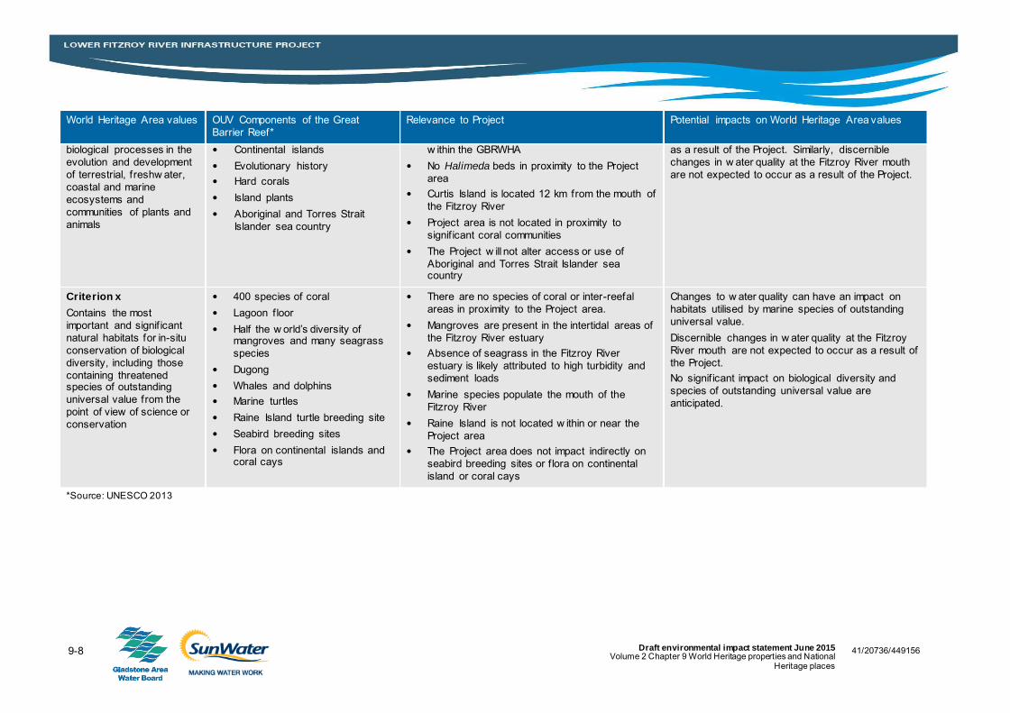
Criterion x
Contains the most
important and signif icant
natural habitats for in-situ
conservation of biological
diversity, including those
containing threatened species of outstanding
universal value from the
point of view of science or
conservation
400 species of coral
Lagoon floor
Half the w orld’s diversity of mangroves and many seagrass
species
Dugong
Whales and dolphins
Marine turtles
Raine Island turtle breeding site
Seabird breeding sites
Flora on continental islands and coral cays
There are no species of coral or inter-reefal
areas in proximity to the Project area.
Mangroves are present in the intertidal areas of
the Fitzroy River estuary
Absence of seagrass in the Fitzroy River
estuary is likely attributed to high turbidity and
sediment loads
Marine species populate the mouth of the
Fitzroy River
Raine Island is not located w ithin or near the
Project area
The Project area does not impact indirectly on
seabird breeding sites or f lora on continental
island or coral cays
Changes to w ater quality can have an impact on
habitats utilised by marine species of outstanding
universal value.
Discernible changes in w ater quality at the Fitzroy
River mouth are not expected to occur as a result of
the Project.
No signif icant impact on biological diversity and
species of outstanding universal value are
anticipated.
*Source: UNESCO 2013

9-9 41/20736/449156 Draft environmental impact statement June 2015 Volume 2 Chapter 9 World Heritage properties and National Heritage places
9.3 National Heritage places
9.3.1 Description of the National Heritage listing
The National Heritage List has been established to list places of outstanding heritage significance
to Australia. It includes natural, historic and Indigenous places that are of outstanding national
heritage value to the Australian nation.
The Great Barrier Reef was was placed on the National Heritage List in May 2007 in accordance
with the provisions of item 1A of Schedule 3 of the Environment and Heritage Legislation
Amendment Act (No.1) 2003 (Cth). The Minister for the then Department of Environment and
Water Resources determined that the Great Barrier Reef should be included on the National
Heritage List as the National Heritage values were demonstrated to be achieved through
corresponding Wold Heritage values identified in Section 9.2.1.
The National Heritage criteria for the Great Barrier Reef are listed below with reference to the
corresponding World Heritage criteria:
a) The place has outstanding heritage value to the nation because of the place’s importance in
the course, or pattern, of Australia’s natural or cultural history
Corresponding to World Heritage criteria (vii), (viii), (ix) and (x)
b) The place has outstanding heritage value to the nation because of the place’s possession of
uncommon, rare or endangered aspects of Australia’s natural or cultural history
Corresponding to World Heritage criteria (x)
c) The place has outstanding heritage value to the nation because of the place’s potential to
yield information that will contribute to an understanding of Australia’s natural or cultural
history
Corresponding to World Heritage criteria (viii), (ix) and (x)
d) The place has outstanding heritage value to the nation because of the place’s importance in
demonstrating the principal characteristics of:
i. A class of Australia’s natural or cultural places; or
ii. A class of Australia’s natural or cultural environments
Corresponding to World Heritage criteria (viii), (ix) and (x)
e) The place has outstanding heritage value to the nation because of the place’s importance in
exhibiting particular aesthetic characteristics valued by a community or cultural group.
Corresponding to World Heritage criteria (vii)
The Great Barrier Reef is also of Indigenous cultural importance for Aboriginal and Torres Strait
Islanders. Non-Indigenous heritage values are also represented and include mapped historic
shipwrecks which occur throughout the reef mosaic. These, along with its biological diversity,
represent features that are of outstanding national heritage value to Australia which led to the
Great Barrier Reef being registered as a place of National Heritage.

9-10 Draft environmental impact statement June 2015 Volume 2 Chapter 9 World Heritage properties and National
Heritage places
41/20736/449156 41/20736/449156 41/20736/449156
9.3.2 Potential indirect impacts
Potential indirect impacts to the National Heritage listed area of the Great Barrier Reef include
changes to surface water flows, water quality and aquatic ecosystems. Further details on these
impacts can be found in Section 9.2.2.
9.3.3 Assessment of significance
As the Great Barrier Reef is the only National Heritage place triggered for the Project, an impact
assessment has been undertaken focusing on National Heritage values for the Great Barrier
Reef.
The Significant impact guidelines 1.1 (DoE 2013) provide overarching guidance on determining
whether an action is likely to have a significant impact on a National Heritage place. An action is
likely to have a significant impact on National Heritage values if there is a real chance or
possibility that it will cause:
One or more of the National Heritage values to be lost
One or more of the National Heritage values to be degraded or damaged
One or more of the National Heritage values to be notably altered, modified, obscured or
diminished (DoE 2013).
As described in section 9.3.1, the values of the Great Barrier for which it was listed as a National
Heritage Place are the same values for which it was listed as a World Heritage property. As such,
the assessment of potential impacts on these values is the same and with the proposed mitigation
and management measures in place, no National Heritage values will be lost, degraded,
damaged, notably altered, modified, obscured or diminished as a result of the Project and
therefore no significant impact on a National Heritage place is likely.
9.4 Summary
The Project will not have any direct impact on the World Heritage values or the National Heritage
values of the Great Barrier Reef as the Project is located 141.2 km AMTD upstream of the Great
Barrier Reef. Potential indirect impacts on the Great Barrier Reef resulting from changes to flow
and water quality have been assessed as follows:
Modelling and statistical analysis has shown that with the Fitzroy Basin Resource Operations
Plan in place there is no significant differences between current modelled freshwater flow
regimes and the flow regimes projected with any additional infrastructure associated with the
Project in place
While it is possible that some localised erosion may occur at the weir sites during operation, it
is considered that the potential additional contribution to the current sediment load entering
the Great Barrier Reef will be negligible
Other than from decaying vegetation, the Project will not directly contribute nutrients
downstream of the Fitzroy River and subsequently the Great Barrier Reef. Water quality
impacts as a result of decaying vegetation will be short term during the initial years of
operation and will not persist into long-term operations
Weir design and operations will seek to reduce the potential for the release of poor quality
water, through measures such as multi-level off takes discharges of poorly oxygenated water
to the Great Barrier Reef are not expected

9-11 41/20736/449156 Draft environmental impact statement June 2015 Volume 2 Chapter 9 World Heritage properties and National Heritage places
Aside from local areas of lower velocity around weir structures such as towers and intakes,
the weirs are expected to provide unimpeded transfer of sediment down the river.
The above impact assessment has concluded that with the management and mitigation measures
in place, no significant impacts to the Great Barrier Reef are expected as a result of the Project.
Furthermore, based on the assessment of potential indirect impacts against Great Barrier Reef
values, the Project will not significantly impact directly or indirectly on the World Heritage values
or National Heritage values of the Great Barrier Reef.