
9 Transporation Element DIA (Planning Horizon 2025)
128
TRANSPORTATION ELEMENT Data Inventory Analysis Lake County, Florida
Transcript of 9 Transporation Element DIA (Planning Horizon 2025)
TRANSPORTATION ELEMENT Data Inventory Analysis
Lake County, Florida
Lake County Planning Horizon 2025
TABLE OF CONTENTS
INTRODUCTION .. . . . . . . . . . . . . . . . . . . . . . . . . . . . . . . . . . . . . . . . . . . . . . . . . . . . . . . . . . . . . . . . . . . . . . . . . . . . . . . . . . . . . . . . . . . . . . . . . . . . 1 TRANSPORTATION AND LAND USE . . . . . . . . . . . . . . . . . . . . . . . . . . . . . . . . . . . . . . . . . . . . . . . . . . . . . . . . . . . . . . . . . . . . . . . . . . . . . . . . . . . . . . . . . . . . 2 EXIST ING ROADWAY CONDITIONS . . . . . . . . . . . . . . . . . . . . . . . . . . . . . . . . . . . . . . . . . . . . . . . . . . . . . . . . . . . . . . . . . . . . . . . . . . . . . . . . . . . . . . . . . . . . 2 EXIST ING FUNCTIONAL CLASSIF ICATION . . . . . . . . . . . . . . . . . . . . . . . . . . . . . . . . . . . . . . . . . . . . . . . . . . . . . . . . . . . . . . . . . . . . . . . . . . . . . . . . . . . 3 EXIST ING ROADWAY OPERATING CONDITIONS . . . . . . . . . . . . . . . . . . . . . . . . . . . . . . . . . . . . . . . . . . . . . . . . . . . . . . . . . . . . . . . . . . . . . . . . . . . . 4 PROGRAMMED ROADWAY IMPROVEMENTS . . . . . . . . . . . . . . . . . . . . . . . . . . . . . . . . . . . . . . . . . . . . . . . . . . . . . . . . . . . . . . . . . . . . . . . . . . . . . . . . . 21 FUTURE ROADWAY CONDITIONS . . . . . . . . . . . . . . . . . . . . . . . . . . . . . . . . . . . . . . . . . . . . . . . . . . . . . . . . . . . . . . . . . . . . . . . . . . . . . . . . . . . . . . . . . . . . . 21 TRANSPORTATION CONCURRENCY . . . . . . . . . . . . . . . . . . . . . . . . . . . . . . . . . . . . . . . . . . . . . . . . . . . . . . . . . . . . . . . . . . . . . . . . . . . . . . . . . . . . . . . . . . . 40 ACCESS MANAGEMENT . . . . . . . . . . . . . . . . . . . . . . . . . . . . . . . . . . . . . . . . . . . . . . . . . . . . . . . . . . . . . . . . . . . . . . . . . . . . . . . . . . . . . . . . . . . . . . . . . . . . . . . . . . 40 BICYCLE TRANSPORTATION . . . . . . . . . . . . . . . . . . . . . . . . . . . . . . . . . . . . . . . . . . . . . . . . . . . . . . . . . . . . . . . . . . . . . . . . . . . . . . . . . . . . . . . . . . . . . . . . . . . 41 PEDESTRIAN CIRCULATION . . . . . . . . . . . . . . . . . . . . . . . . . . . . . . . . . . . . . . . . . . . . . . . . . . . . . . . . . . . . . . . . . . . . . . . . . . . . . . . . . . . . . . . . . . . . . . . . . . . . 42
Mass Transit.......................................................................................................................................................................... 42
MAJOR TRIP GENERATORS AND ATTRACTORS . . . . . . . . . . . . . . . . . . . . . . . . . . . . . . . . . . . . . . . . . . . . . . . . . . . . . . . . . . . . 43
EXISTING PUBLIC TRANSPORTATION FACILITIES/SERVICES . . . . . . . . . . . . . . . . . . . . . . . . . . . . . . . . . . . . . . . . . . 43 Marketing Techniques And Program...................................................................................................................................... 43
PUBLIC TRANSPORTATION NEEDS AND POTENTIAL MARKETS . . . . . . . . . . . . . . . . . . . . . . . . . . . . . . . . . . . . . . . . 45 Public Transportation Strategies to Meet Identified Needs .................................................................................................... 48
RECOMMENDED NEW PUBLIC TRANSPORTATION SERVICES AND OPERATING CHARACTERISTICS. . . . . . . . . . . . . . . . . . . . . . . . . . . . . . . . . . . . . . . . . . . . . . . . . . . . . . . . . . . . . . . . . . . . . . . . . . . . . . . . . . . . . . . . . . . . . . . . 49
SERVICE ENHANCEMENTS : . . . . . . . . . . . . . . . . . . . . . . . . . . . . . . . . . . . . . . . . . . . . . . . . . . . . . . . . . . . . . . . . . . . . . . . . . . . . . . . . . . . . . . . . . . . . . . . . . . . . . 49 IMPLEMENTATION OF F IXED-ROUTE BUS SERVICE : . . . . . . . . . . . . . . . . . . . . . . . . . . . . . . . . . . . . . . . . . . . . . . . . . . . . . . . . . . . . . . . . . . . . . . 49
Coordination with other Fixed-Route Services: ...................................................................................................................... 50 AVIATION/ RAIL . . . . . . . . . . . . . . . . . . . . . . . . . . . . . . . . . . . . . . . . . . . . . . . . . . . . . . . . . . . . . . . . . . . . . . . . . . . . . . . . . . . . . . . . . . . . . . . . . . . . . . . . . . . . . . . . . 50 EXIST ING OPERATIONS AND FACIL IT IES/SERVICES . . . . . . . . . . . . . . . . . . . . . . . . . . . . . . . . . . . . . . . . . . . . . . . . . . . . . . . . . . . . . . . . . . . . . . 52
Existing/Future Land Use....................................................................................................................................................... 53 Future Operations Projections............................................................................................................................................... 53
PLANNED IMPROVEMENTS . . . . . . . . . . . . . . . . . . . . . . . . . . . . . . . . . . . . . . . . . . . . . . . . . . . . . . . . . . . . . . . . . . . . . . . . . . . . . . . . . . . . . . . . . . . . . . . . . . . . . 54 ENVIRONMENTAL IMPACT SUMMARY . . . . . . . . . . . . . . . . . . . . . . . . . . . . . . . . . . . . . . . . . . . . . . . . . . . . . . . . . . . . . . . . . . . . . . . . . . . . . . . . . . . . . . . . 54 FUNDING SOURCES FOR LEESBURG REGIONAL AIRPORT . . . . . . . . . . . . . . . . . . . . . . . . . . . . . . . . . . . . . . . . . . . . . . . . . . . . . . . . . . . . . . . . 54
Umatilla Municipal Airport..................................................................................................................................................... 59 EXIST ING OPERATIONS AND FACIL IT IES/SERVICES . . . . . . . . . . . . . . . . . . . . . . . . . . . . . . . . . . . . . . . . . . . . . . . . . . . . . . . . . . . . . . . . . . . . . . 59
Transportation Element Data Inventory Analysis
iii
Future Based Aircraft and Operations Projections ................................................................................................................. 59 Airport Operations Forecast Summary: ................................................................................................................................. 60 Planned Improvements ......................................................................................................................................................... 60
FUNDING SOURCES FOR UMATILLA MUNICIPAL AIRPORT: . . . . . . . . . . . . . . . . . . . . . . . . . . . . . . . . . . . . . . . . . . . . . 61
UMATILLA MUNICIPAL AIRPORT IMPROVEMENT SCHEDULE . . . . . . . . . . . . . . . . . . . . . . . . . . . . . . . . . . . . . . . . . . . 62 Mid-Florida Airport................................................................................................................................................................ 65
PROJECTED OPERATIONS: . . . . . . . . . . . . . . . . . . . . . . . . . . . . . . . . . . . . . . . . . . . . . . . . . . . . . . . . . . . . . . . . . . . . . . . . . . . . . . . . . . . . . . . . . . . . . . . . . . . . . 66 Planned Improvements: ........................................................................................................................................................ 66
RAIL FACIL IT IES . . . . . . . . . . . . . . . . . . . . . . . . . . . . . . . . . . . . . . . . . . . . . . . . . . . . . . . . . . . . . . . . . . . . . . . . . . . . . . . . . . . . . . . . . . . . . . . . . . . . . . . . . . . . . . . . . 66
LIST OF TABLES
Table 1 – Road Classifications ........................................................................................................................................................... 1 Table 2 – Roadway Classification by Function ................................................................................................................................... 3 Table 3 - Lake County Existing Roadway Conditions .......................................................................................................................... 5 Table 4 - Summary of Improvements............................................................................................................................................... 22 Table 5 - 2025 Roadway Conditions ................................................................................................................................................. 23 Table 6 - Bicycle Lanes Defined........................................................................................................................................................ 41 Table 7 - Selected Transit Marketing Techniques.............................................................................................................................. 44 Table 8 - Primary Corridors ............................................................................................................................................................. 47 Table 9 - Secondary Corridors.......................................................................................................................................................... 47 Table 10 - Potential CTC Routes........................................................................................................................................................ 49 Table 11 - Leesburg Regional Airport Operational Statistics ............................................................................................................ 52 Table 12 - Airport Operations Forecast Summary ............................................................................................................................ 53 Table 13 - Leesburg Regional Airport Capital Improvement Plan Fiscal years 2005-2015 ................................................................ 56 Table 14 - Umatilla Municipal Airport Services................................................................................................................................. 59 Table 15 - Umatilla Municipal Airport Operations Forecast Summary............................................................................................... 60 Table 16 - Umatilla Municipal Airport Operational Statistics ............................................................................................................ 60 Table 17 - Umatilla Airport Planned Improvements Summary ......................................................................................................... 60 Table 18 - Umatilla Municipal Airport Capital Improvements ........................................................................................................... 63 Table 19 - Mid-Florida Airport Operational Statistics ....................................................................................................................... 65 Table 20 - Mid-Florida Airport Services............................................................................................................................................ 66

Transportation Element Data Inventory Analysis
TE – DIA 1 of 128
INTRODUCTION
Lake County is located within the Lake-Sumter Metropolitan Planning Organization (LSMPO) boundary. Therefore, the County is required by the State to adopt a Transportation Element in lieu of three separate sub-elements: traffic circulation, mass transit, and aviation and rail. The purpose of the Transportation Element is to plan for a multi-modal transportation system that emphasizes accessibility.
The Lake County transportation planning process is a collaborative effort among various federal, state, regional, county, and municipal agencies working in close concert with the LSMPO. The LSMPO ensures that highways and roads, public transit, pedestrian, bicycle, and other transportation facilities are coordinated and planned with consistency.
An inventory of the existing traffic circulation system has been prepared as the basis for examining the existing roadway deficiencies and determining future roadway needs. The Florida Department of Transportation (FDOT) and Lake County provide the data necessary for the inventory of the existing system. The traffic circulation system consists of roads within the County which are part of both the State Highway and County Roadway Systems.
Lake County has a current traffic circulation system comprised of three types of traffic facilities (arterial, collector and local facilities) that are organized into three separate classifications based on the existing FDOT roadway functional classifications. Inter county, intra-county, and local traffic all use the traffic circulation system within Lake County. The three road classifications, as defined in section 9J-5.003, FAC., are based on the relationship between the movement of traffic and the degree of access to surrounding land uses, and are as follows:
Table 1 – Road Classifications
Local Road Provides access to local properties and connects them to higher classified roadways
Collector Provides a connection between local roads at higher speeds and capacities and connects rural and urban areas.
Arterial Arterials are designed to move high volumes of traffic at high speeds over long distances, mostly between counties.
Lake County is located in East Central Florida and is bordered by seven counties. The adjoining counties are Volusia, Seminole, Orange, Osceola, Polk, Sumter, and Marion counties. Lake County is composed of 1,157 square miles, with 953 square miles of land area and 204 square miles of water area. Along with a relatively high growth rate, Lake County is characterized by a large number of lakes, low population densities, and a large service area. The hydrography of Lake County – that is, the large number and geographic distribution of lakes – inhibits the establishment of any type of large-scale grid-like road network.
Lake County adopted the Lake County 2025 Long Range Transportation Plan on December 14, 2005; it was completed for Lake County by Tindale-Oliver and Associates. This plan contains an extensive analysis of roadway, bicycle, and pedestrian transportation issues, as well as land use and other factors that determine existing and future needs. The result of the plan is a comprehensive schedule of roadway bicycle transit, and pedestrian projects designed to meet as
Lake County Planning Horizon 2025
TE – DIA 2 of 128
much as possible the existing and future needs of Lake County. Much of the information provided in that report is included in this document.
TRANSPORTATION AND LAND USE
The Lake-Sumter Metropolitan Planning Organization (LSMPO) wrote their 2025 Long Range Transportation Plan based on population and employment projections, and the projected development pattern out to 2025. Based on theses projections, the LSMPO and Lake County can enact the strategies and projects needed to ensure that Lake County will meet its transportation goals for the next twenty years. The LSMPO and Lake County have worked closely so that there is consistency between The Transportation Element and the 2025 Long Range Transportation Plan.
EXISTING ROADWAY CONDITIONS
Rather than being dominated by one large city or town, Lake County has a collection of medium and small cities, including Leesburg, Tavares, and Eustis. A significant portion of daily travel, including commuter traffic occurs between these cities. In south Lake County, much of the traffic runs along SR 50. It is evident that the automobile plays a significant role in the mobility of Lake County residents.
Because of the numerous lakes in Lake County, most travel occurs on arterial roadways that are fed by collector and local roads. All arterial roadways in Lake County are State-maintained, with most collector roadways being County roads. The principal travel corridors in Lake County include the following State roadways:
US Highway 27 (SR 25) extends from the southern Polk/Lake county line north through the city of Clermont, merging with US 441 (SR 500) in Leesburg, and continues north to Sumter and Marion counties. US 27 intersects Florida’s Turnpike in central Lake County, and provides a connection to I-4 in Polk County. US 27 is a four-lane roadway with some six-lane segments.
US Highway 441 (SR 500) enters Lake County from the north at the Sumter County border, sharing a designation with US 27 (SR 25). It continues into Leesburg, where it diverges from US 27, and turns east, extending through Tavares, south of Eustis, and around Mount Dora. It then turns south, exiting Lake County at the Orange County line. US 441 serves a great majority of the development and activity centers in Lake County, and this is reflected in the heavy traffic volumes along this corridor. US 441 is undergoing construction for conversion to a six-lane road throughout its length in Lake County.
Florida’s Turnpike (SR 91) is a four-lane toll limited-access facility maintained by the Turnpike Enterprise District. Florida’s Turnpike enters west-central Lake County at the Sumter County line, traveling southeast to the Orange County line near Lake Apopka. Most of the traffic on the Turnpike is through traffic. There are three interchanges in Lake County:
1. US 27/SR19 south of Leesburg
2. SR 50 near the Orange County line near Clermont.
3. CR 470, which encourages greater intra-county travel on the Turnpike.

Transportation Element Data Inventory Analysis
TE – DIA 3 of 128
SR 19 begins in Groveland at SR 50 in southern Lake County, crosses Florida’s Turnpike, and continues north to Tavares, where it merges with US 441. East of Tavares, it splits from US 441, traveling through Eustis and Umatilla, and continuing north into the Ocala National Forest, exiting Lake County at the Marion County line at SR 40. Most of SR 19 is two lanes, except for a four-lane segment through Eustis and Umatilla, with four and six lane segments in Tavares.
SR 40 crosses east and west through the northern most portion of Lake County, extends from Marion County to Volusia County. It is a two-lane road, and is part of the Florida Intrastate Highway System (FIHS).
SR 44 enters Lake County from the west at the Sumter County line, and links Leesburg to I-75. It joins with US 441 in Leesburg, diverges in Mount Dora and continues east and northeast, crossing the Wekiva River Protection Area, and exiting Lake County at the Volusia County Line. SR 44 is a four-lane road from Sumter County line to Mount Dora, then becomes 2-lanes.
SR 46 runs west to east from Mount Dora to Seminole County as a two-lane roadway.
SR 50 crosses Lake County from west to east, beginning at the Sumter County line west of Mascotte, continuing through Groveland and Clermont, then exiting Lake County at the Orange County Line, connecting Clermont with the Orlando metropolitan area. SR 50 is a two-lane road west of Groveland, and four lanes from Groveland to Orange County. The segment from US 27 in Clermont to the Orange County line is scheduled for reconstruction as a six-lane facility.
The County road system that complements the State Highway System is a collection of mostly two-lane roads providing collector and land access functions. Because of the surface water topography of Lake County and environmentally sensitive areas, there are few opportunities to provide parallel relievers to over-crowded roads. In the few cases where this is possible, it occurs mostly in the undeveloped areas of the county not susceptible to traffic congestion.
EXISTING FUNCTIONAL CLASSIFICATION
Roads in Lake County are functionally classified according to State and Federal classification criteria. These criteria establish the classification of a roadway according to the function the roadway serves. Functional Classifications include:
Table 2 – Roadway Classification by Function
Local Road Provides access to local properties, and connects them to higher-classified roadways.
Rural Minor Collector Provides a connection from local streets, connecting those streets to higher-classified roadways in rural areas and providing higher speeds and capacities than local roads.
Rural Major Collector Provides higher speeds and capacities than minor collectors, and connects to collectors in urban areas.
Urban Collector Provides connections between local streets at higher speeds. And capacities in urbanized areas.
Minor Arterial Serves longer, commuter-type trips, and moves traffic among various areas of the County. Provides a connection between major collector roads in the County. Speeds and capacities are commensurately higher than collector roadways.
Principal Arterial The highest classification of roadway. Principal arterials are designed to move large volumes of traffic at high speeds over long distances, mostly between counties.

Lake County Planning Horizon 2025
TE – DIA 4 of 128
Lake County has established a policy delineating Scenic Roadways, which are roads determined to be of such scenic quality that any benefit provided by widening such roads would be offset by the detriment to the character of Lake County should such widening be allowed.
Related to functional classification Lake County has established specifications addressing the maximum number of lanes allowed for roads according to their functional classification. Roads designated as Scenic Roadways are limited to two lanes. Otherwise, arterial roadways are limited to six lanes, collectors are limited to four lanes, and local streets to two lanes.
Lake County, through the Land Development Regulations, has also established minimum right-of-way standards for roadways according to a road’s functional classification. These right-of-way specifications are designed to ensure the protection of right-of-way needed for future road projects, and are part of the development review process. Given the escalating cost of right-of-way in Florida, the protection of future needed right-of-way is a crucial part of the transportation planning process.
EXISTING ROADWAY OPERATING CONDITIONS
For the most part, roadways in Lake County operate at or above the established Lake County Comprehensive Plan level of service standards. The exceptions to this can be found in highly developed areas in the central part of the county. This includes US 441 in Leesburg and SR 19 in Eustis and south of Tavares, CR 44 bypassing downtown areas to the north of Lake Eustis, and SR 46. US 441 is currently programmed for six laning from the Orange County line north to the Sumter County line. Portions of this highway are already 6-lanes with the remaining portions experiencing failing level of service in certain segments. In South Lake County, SR 50 is also experiencing level of service failures on certain segments. For a comprehensive list of road improvements see the 2006-2010 Transportation Construction Program (Appendix A) and the Five Year Transportation Improvement Program (Appendix B); the 2005 Traffic Counts can be found in Appendix C.

Transportation Element Data Inventory Analysis
TE – DIA 5 of 128
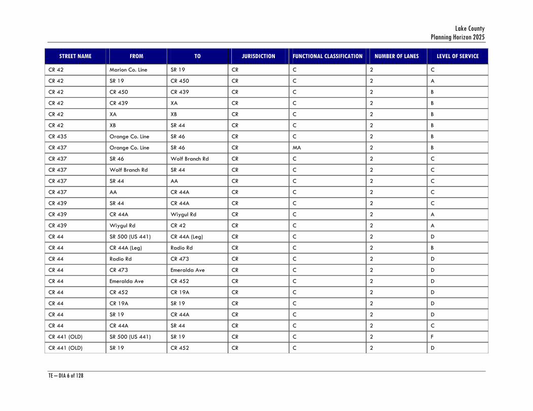
Table 3 - Lake County Existing Roadway Conditions
STREET NAME FROM TO JURISDICTION FUNCTIONAL CLASSIFICATION NUMBER OF LANES LEVEL OF SERVICE
Ardice Ave Golf Links Kurt St CR C 2 *
Ardice Ave Kurt St SR 19 CR C 2 *
CR 19A (W) CR 441 (Old) Merry Rd CR C 2 C
CR 19A (W) Merry Rd Lake Saunders CR C 2 C
CR 19A (W) Lake Saunders SR 500 (US 441) CR C 2 C
CR 19A (E) CR 441 Lake Saunders CR C 2 E
CR 19A (E) Lake Saunders SR 500 (US 441) CR C 2 E
CR 19A CR 452 CR 44 CR C 2 C
CR 19A CR 44 SR 19 CR C 2 C
CR 25 US 27/US 441 (S) US 27/US 441 (N) CR C 2 C
CR 25 US 27 Marion Co Rd CR C 2 C
CR 25 Marion Co Rd Marion Co. Line CR C 2 C
CR 25 A US 27/US 441 (S) Thomas St CR C 2 C
CR 25 A Thomas St CR466A CR C 2 C
CR 25 A CR466A US 27/US 441 (N) CR C 2 C
CR 25 A US 27 (South) Q CR C 2 C
CR 25 A Q US 27 (North) CR C 2 C
CR 33 SR 50 Sunset Av CR C 2 B
CR 33 Sunset Ave Simon Brown Rd CR C 2 B
CR 33 Simon Brown Rd I CR C 2 B
CR 33 I Austin Merritt CR C 2 B
CR 33 Austin Merritt CR 48 CR C 2 B
CR 33 CR 48 CR 470 CR C 2 C
CR 33 CR 470 SR 25 CR C 2 D
CR 40 SR 40 (West) SR 40 (East) CR C 2 *
Lake County Planning Horizon 2025
TE – DIA 6 of 128
STREET NAME FROM TO JURISDICTION FUNCTIONAL CLASSIFICATION NUMBER OF LANES LEVEL OF SERVICE
CR 42 Marion Co. Line SR 19 CR C 2 C
CR 42 SR 19 CR 450 CR C 2 A
CR 42 CR 450 CR 439 CR C 2 B
CR 42 CR 439 XA CR C 2 B
CR 42 XA XB CR C 2 B
CR 42 XB SR 44 CR C 2 B
CR 435 Orange Co. Line SR 46 CR C 2 B
CR 437 Orange Co. Line SR 46 CR MA 2 B
CR 437 SR 46 Wolf Branch Rd CR C 2 C
CR 437 Wolf Branch Rd SR 44 CR C 2 C
CR 437 SR 44 AA CR C 2 C
CR 437 AA CR 44A CR C 2 C
CR 439 SR 44 CR 44A CR C 2 C
CR 439 CR 44A Wiygul Rd CR C 2 A
CR 439 Wiygul Rd CR 42 CR C 2 A
CR 44 SR 500 (US 441) CR 44A (Leg) CR C 2 D
CR 44 CR 44A (Leg) Radio Rd CR C 2 B
CR 44 Radio Rd CR 473 CR C 2 D
CR 44 CR 473 Emeralda Ave CR C 2 D
CR 44 Emeralda Ave CR 452 CR C 2 D
CR 44 CR 452 CR 19A CR C 2 D
CR 44 CR 19A SR 19 CR C 2 D
CR 44 SR 19 CR 44A CR C 2 D
CR 44 CR 44A SR 44 CR C 2 C
CR 441 (OLD) SR 500 (US 441) SR 19 CR C 2 F
CR 441 (OLD) SR 19 CR 452 CR C 2 D

Transportation Element Data Inventory Analysis
TE – DIA 7 of 128
STREET NAME FROM TO JURISDICTION FUNCTIONAL CLASSIFICATION NUMBER OF LANES LEVEL OF SERVICE
CR 441 (OLD) CR 452 CR 19A CR C 2 D
CR 441 (OLD) CR 19A Old Hammock CR C 2 D
CR 441 (OLD) Old Hammock CR 44C CR C 2 D
CR 441 (OLD) CR 44C Morningside CR C 2 E
CR 441 (OLD) Morningside CR 452 CR C 2 E
CR 441 (OLD) CR 452 Donnelly St CR C 2 E
CR 441 (OLD) Donnelly St SR 46 CR C 2 E
CR 441 (OLD) SR 46 Orange Co. Line CR C 2 C
CR 445 SR 19 XB CR C 2 A
CR 445 XB CR 445A CR C 2 A
CR 445A SR 19 CR 445 CR C 2 A
CR 445A CR 445 SR 40 CR C 2 A
CR 448 CR 561 Frankies Rd CR C 2 C
CR 448 Frankies Rd Lake Rd CR C 2 B
CR 448 Lake Rd CR 448A CR C 2 B
CR 448 CR 448A Orange Co. Line CR C 2 C
CR 448A CR 48 CR 448 CR C 2 *
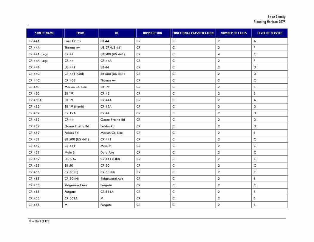
CR 44A SR 19 Wiygul Rd CR C 2 A
CR 44A Wiygul Rd CR 450A CR C 2 B
CR 44A CR 450A Bill Collins Rd CR C 2 B
CR 44A Bill Collins Rd Estes Rd CR C 2 B
CR 44A Estes Rd N Thrill Hill R CR C 2 B
CR 44A N Thrill Hill R CR 439 CR C 2 B
CR 44A CR 439 AA CR C 2 B
CR 44A AA CR 437 CR C 2 B
CR 44A CR 437 Lake Norris CR C 2 A
Lake County Planning Horizon 2025
TE – DIA 8 of 128
STREET NAME FROM TO JURISDICTION FUNCTIONAL CLASSIFICATION NUMBER OF LANES LEVEL OF SERVICE
CR 44A Lake Norris SR 44 CR C 2 A
CR 44A Thomas Av US 27/US 441 CR C 2 *
CR 44A (Leg) CR 44 SR 500 (US 441) CR C 4 C
CR 44A (Leg) CR 44 CR 44A CR C 2 *
CR 44B US 441 SR 44 CR C 2 D
CR 44C CR 441 (Old) SR 500 (US 441) CR C 2 D
CR 44C CR 468 Thomas Av CR C 2 C
CR 450 Marion Co. Line SR 19 CR C 2 B
CR 450 SR 19 CR 42 CR C 2 B
CR 450A SR 19 CR 44A CR C 2 A
CR 452 SR 19 (North) CR 19A CR C 2 D
CR 452 CR 19A CR 44 CR C 2 D
CR 452 CR 44 Goose Prairie Rd CR C 2 D
CR 452 Goose Prairie Rd Felkins Rd CR C 2 D
CR 452 Felkins Rd Marion Co. Line CR C 2 B
CR 452 SR 500 (US 441) CR 441 CR C 2 C
CR 452 CR 441 Main St CR C 2 C
CR 452 Main St Dora Ave CR C 2 C
CR 452 Dora Av CR 441 (Old) CR C 2 C
CR 455 SR 50 CR 50 CR C 2 C
CR 455 CR 50 (S) CR 50 (N) CR C 2 C
CR 455 CR 50 (N) Ridgewood Ave CR C 2 B
CR 455 Ridgewood Ave Fosgate CR C 2 C
CR 455 Fosgate CR 561A CR C 2 B
CR 455 CR 561A M CR C 2 B
CR 455 M Fosgate CR C 2 B
Transportation Element Data Inventory Analysis
TE – DIA 9 of 128
STREET NAME FROM TO JURISDICTION FUNCTIONAL CLASSIFICATION NUMBER OF LANES LEVEL OF SERVICE
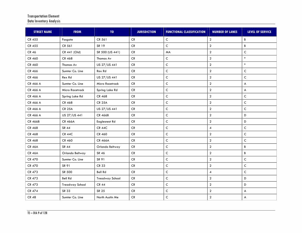
CR 455 Fosgate CR 561 CR C 2 B
CR 455 CR 561 SR 19 CR C 2 B
CR 46 CR 441 (Old) SR 500 (US 441) CR MA 2 C
CR 460 CR 468 Thomas Av CR C 2 *
CR 460 Thomas Av US 27/US 441 CR C 2 *
CR 466 Sumter Co. Line Rex Rd CR C 2 C
CR 466 Rex Rd US 27/US 441 CR C 2 C
CR 466 A Sumter Co. Line Micro Racetrack CR C 2 A
CR 466 A Micro Racetrack Spring Lake Rd CR C 2 A
CR 466 A Spring Lake Rd CR 468 CR C 2 C
CR 466 A CR 468 CR 25A CR C 2 C
CR 466 A CR 25A US 27/US 441 CR C 2 C
CR 466 A US 27/US 441 CR 466B CR C 2 D
CR 466B CR 466A Eaglesnest Rd CR C 2 D
CR 468 SR 44 CR 44C CR C 4 C
CR 468 CR 44C CR 460 CR C 2 C
CR 468 CR 460 CR 466A CR C 2 C
CR 46A SR 44 Orlando Beltway CR C 2 B
CR 46A Orlando Beltway SR 46 CR C 2 B
CR 470 Sumter Co. Line SR 91 CR C 2 C
CR 470 SR 91 CR 33 CR C 2 C
CR 473 SR 500 Bell Rd CR C 4 C
CR 473 Bell Rd Treadway School CR C 2 D
CR 473 Treadway School CR 44 CR C 2 D
CR 474 SR 33 SR 25 CR C 2 A
CR 48 Sumter Co. Line North Austin Me CR C 2 A
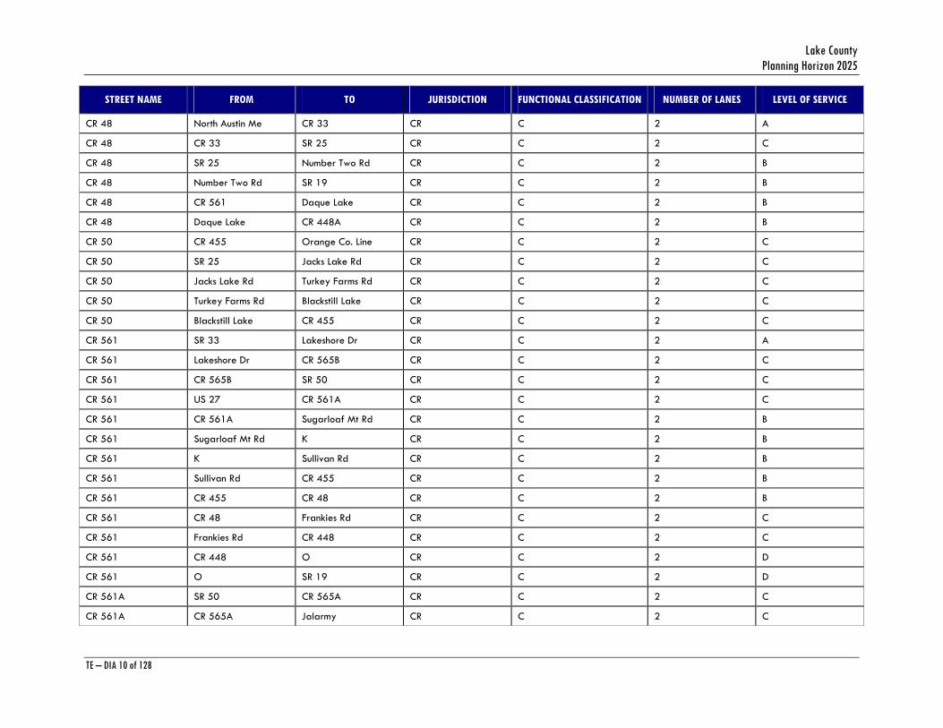
Lake County Planning Horizon 2025
TE – DIA 10 of 128
STREET NAME FROM TO JURISDICTION FUNCTIONAL CLASSIFICATION NUMBER OF LANES LEVEL OF SERVICE
CR 48 North Austin Me CR 33 CR C 2 A
CR 48 CR 33 SR 25 CR C 2 C
CR 48 SR 25 Number Two Rd CR C 2 B
CR 48 Number Two Rd SR 19 CR C 2 B
CR 48 CR 561 Daque Lake CR C 2 B
CR 48 Daque Lake CR 448A CR C 2 B
CR 50 CR 455 Orange Co. Line CR C 2 C
CR 50 SR 25 Jacks Lake Rd CR C 2 C
CR 50 Jacks Lake Rd Turkey Farms Rd CR C 2 C
CR 50 Turkey Farms Rd Blackstill Lake CR C 2 C
CR 50 Blackstill Lake CR 455 CR C 2 C
CR 561 SR 33 Lakeshore Dr CR C 2 A
CR 561 Lakeshore Dr CR 565B CR C 2 C
CR 561 CR 565B SR 50 CR C 2 C
CR 561 US 27 CR 561A CR C 2 C
CR 561 CR 561A Sugarloaf Mt Rd CR C 2 B
CR 561 Sugarloaf Mt Rd K CR C 2 B
CR 561 K Sullivan Rd CR C 2 B
CR 561 Sullivan Rd CR 455 CR C 2 B
CR 561 CR 455 CR 48 CR C 2 B
CR 561 CR 48 Frankies Rd CR C 2 C
CR 561 Frankies Rd CR 448 CR C 2 C
CR 561 CR 448 O CR C 2 D
CR 561 O SR 19 CR C 2 D
CR 561A SR 50 CR 565A CR C 2 C
CR 561A CR 565A Jalarmy CR C 2 C
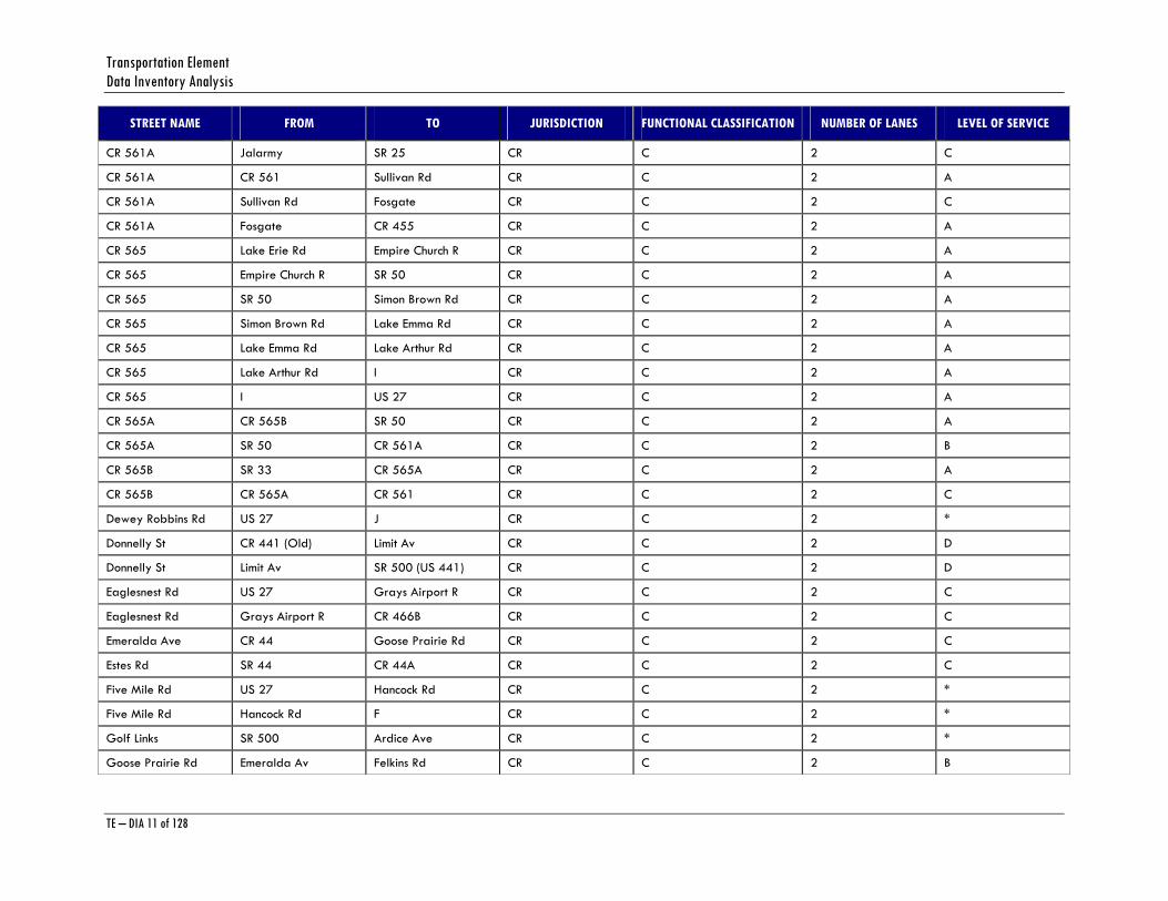
Transportation Element Data Inventory Analysis
TE – DIA 11 of 128
STREET NAME FROM TO JURISDICTION FUNCTIONAL CLASSIFICATION NUMBER OF LANES LEVEL OF SERVICE
CR 561A Jalarmy SR 25 CR C 2 C
CR 561A CR 561 Sullivan Rd CR C 2 A
CR 561A Sullivan Rd Fosgate CR C 2 C
CR 561A Fosgate CR 455 CR C 2 A
CR 565 Lake Erie Rd Empire Church R CR C 2 A
CR 565 Empire Church R SR 50 CR C 2 A
CR 565 SR 50 Simon Brown Rd CR C 2 A
CR 565 Simon Brown Rd Lake Emma Rd CR C 2 A
CR 565 Lake Emma Rd Lake Arthur Rd CR C 2 A
CR 565 Lake Arthur Rd I CR C 2 A
CR 565 I US 27 CR C 2 A
CR 565A CR 565B SR 50 CR C 2 A
CR 565A SR 50 CR 561A CR C 2 B
CR 565B SR 33 CR 565A CR C 2 A
CR 565B CR 565A CR 561 CR C 2 C
Dewey Robbins Rd US 27 J CR C 2 *
Donnelly St CR 441 (Old) Limit Av CR C 2 D
Donnelly St Limit Av SR 500 (US 441) CR C 2 D
Eaglesnest Rd US 27 Grays Airport R CR C 2 C
Eaglesnest Rd Grays Airport R CR 466B CR C 2 C
Emeralda Ave CR 44 Goose Prairie Rd CR C 2 C
Estes Rd SR 44 CR 44A CR C 2 C
Five Mile Rd US 27 Hancock Rd CR C 2 *
Five Mile Rd Hancock Rd F CR C 2 *
Golf Links SR 500 Ardice Ave CR C 2 *
Goose Prairie Rd Emeralda Av Felkins Rd CR C 2 B
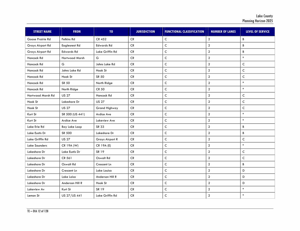
Lake County Planning Horizon 2025
TE – DIA 12 of 128
STREET NAME FROM TO JURISDICTION FUNCTIONAL CLASSIFICATION NUMBER OF LANES LEVEL OF SERVICE
Goose Prairie Rd Felkins Rd CR 452 CR C 2 B
Grays Airport Rd Eaglesnest Rd Edwards Rd CR C 2 B
Grays Airport Rd Edwards Rd Lake Griffin Rd CR C 2 B
Hancock Rd Hartwood Marsh G CR C 2 *
Hancock Rd G Johns Lake Rd CR C 2 C
Hancock Rd Johns Lake Rd Hook St CR C 2 C
Hancock Rd Hook St SR 50 CR C 2 C
Hancock Rd SR 50 North Ridge CR C 2 *
Hancock Rd North Ridge CR 50 CR C 2 *
Hartwood Marsh Rd US 27 Hancock Rd CR C 2 C
Hook St Lakeshore Dr US 27 CR C 2 C
Hook St US 27 Grand Highway CR C 2 C
Kurt St SR 500 (US 441) Ardice Ave CR C 2 *
Kurt St Ardice Ave Lakeview Ave CR C 2 *
Lake Erie Rd Bay Lake Loop SR 33 CR C 2 B
Lake Eustis Dr SR 500 Lakeshore Dr CR C 2 B
Lake Griffin Rd US 27 Grays Airport R CR C 2 C
Lake Saunders CR 19A (W) CR 19A (E) CR C 2 *
Lakeshore Dr Lake Eustis Dr SR 19 CR C 2 C
Lakeshore Dr CR 561 Oswalt Rd CR C 2 C
Lakeshore Dr Oswalt Rd Crescent Ln CR C 2 B
Lakeshore Dr Crescent Ln Lake Louisa CR C 2 D
Lakeshore Dr Lake Loisa Anderson Hill R CR C 2 D
Lakeshore Dr Anderson Hill R Hook St CR C 2 D
Lakeview Av Kurt St SR 19 CR C 2 *
Lemon St US 27/US 441 Lake Griffin Rd CR C 2 *
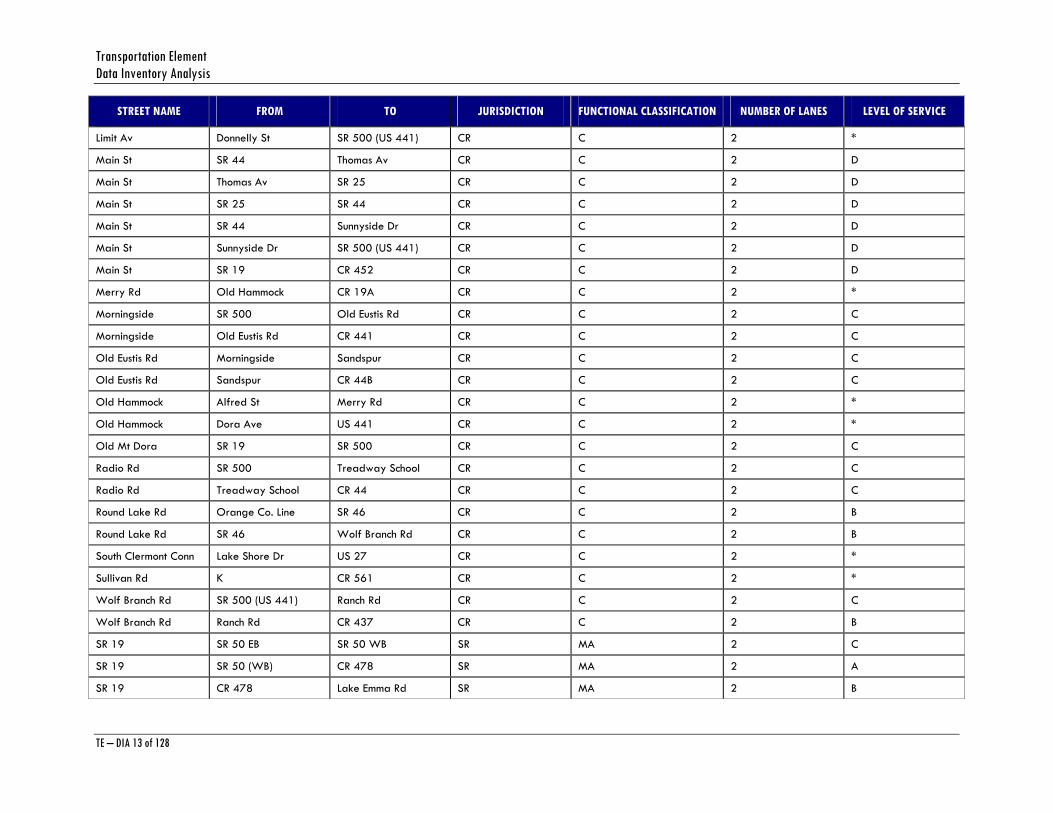
Transportation Element Data Inventory Analysis
TE – DIA 13 of 128
STREET NAME FROM TO JURISDICTION FUNCTIONAL CLASSIFICATION NUMBER OF LANES LEVEL OF SERVICE
Limit Av Donnelly St SR 500 (US 441) CR C 2 *
Main St SR 44 Thomas Av CR C 2 D
Main St Thomas Av SR 25 CR C 2 D
Main St SR 25 SR 44 CR C 2 D
Main St SR 44 Sunnyside Dr CR C 2 D
Main St Sunnyside Dr SR 500 (US 441) CR C 2 D
Main St SR 19 CR 452 CR C 2 D
Merry Rd Old Hammock CR 19A CR C 2 *
Morningside SR 500 Old Eustis Rd CR C 2 C
Morningside Old Eustis Rd CR 441 CR C 2 C
Old Eustis Rd Morningside Sandspur CR C 2 C
Old Eustis Rd Sandspur CR 44B CR C 2 C
Old Hammock Alfred St Merry Rd CR C 2 *
Old Hammock Dora Ave US 441 CR C 2 *
Old Mt Dora SR 19 SR 500 CR C 2 C
Radio Rd SR 500 Treadway School CR C 2 C
Radio Rd Treadway School CR 44 CR C 2 C
Round Lake Rd Orange Co. Line SR 46 CR C 2 B
Round Lake Rd SR 46 Wolf Branch Rd CR C 2 B
South Clermont Conn Lake Shore Dr US 27 CR C 2 *
Sullivan Rd K CR 561 CR C 2 *
Wolf Branch Rd SR 500 (US 441) Ranch Rd CR C 2 C
Wolf Branch Rd Ranch Rd CR 437 CR C 2 B
SR 19 SR 50 EB SR 50 WB SR MA 2 C
SR 19 SR 50 (WB) CR 478 SR MA 2 A
SR 19 CR 478 Lake Emma Rd SR MA 2 B
Lake County Planning Horizon 2025
TE – DIA 14 of 128
STREET NAME FROM TO JURISDICTION FUNCTIONAL CLASSIFICATION NUMBER OF LANES LEVEL OF SERVICE
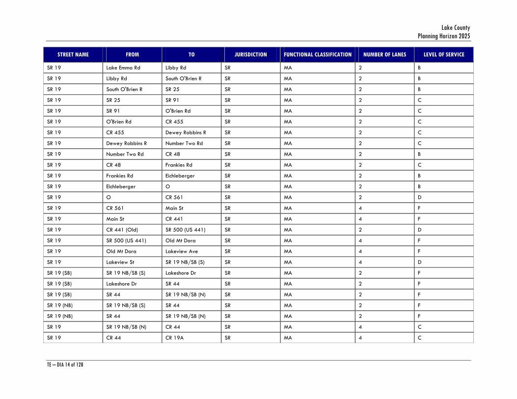
SR 19 Lake Emma Rd Libby Rd SR MA 2 B
SR 19 Libby Rd South O'Brien R SR MA 2 B
SR 19 South O'Brien R SR 25 SR MA 2 B
SR 19 SR 25 SR 91 SR MA 2 C
SR 19 SR 91 O'Brien Rd SR MA 2 C
SR 19 O'Brien Rd CR 455 SR MA 2 C
SR 19 CR 455 Dewey Robbins R SR MA 2 C
SR 19 Dewey Robbins R Number Two Rd SR MA 2 C
SR 19 Number Two Rd CR 48 SR MA 2 B
SR 19 CR 48 Frankies Rd SR MA 2 C
SR 19 Frankies Rd Eichleberger SR MA 2 B
SR 19 Eichleberger O SR MA 2 B
SR 19 O CR 561 SR MA 2 D
SR 19 CR 561 Main St SR MA 4 F
SR 19 Main St CR 441 SR MA 4 F
SR 19 CR 441 (Old) SR 500 (US 441) SR MA 2 D
SR 19 SR 500 (US 441) Old Mt Dora SR MA 4 F
SR 19 Old Mt Dora Lakeview Ave SR MA 4 F
SR 19 Lakeview St SR 19 NB/SB (S) SR MA 4 D
SR 19 (SB) SR 19 NB/SB (S) Lakeshore Dr SR MA 2 F
SR 19 (SB) Lakeshore Dr SR 44 SR MA 2 F
SR 19 (SB) SR 44 SR 19 NB/SB (N) SR MA 2 F
SR 19 (NB) SR 19 NB/SB (S) SR 44 SR MA 2 F
SR 19 (NB) SR 44 SR 19 NB/SB (N) SR MA 2 F
SR 19 SR 19 NB/SB (N) CR 44 SR MA 4 C
SR 19 CR 44 CR 19A SR MA 4 C

Transportation Element Data Inventory Analysis
TE – DIA 15 of 128
STREET NAME FROM TO JURISDICTION FUNCTIONAL CLASSIFICATION NUMBER OF LANES LEVEL OF SERVICE
SR 19 CR 19A CR 450A SR MA 4 B
SR 19 CR 450A CR 44A SR MA 4 A
SR 19 CR 44A CR 450 (South) SR MA 4 C
SR 19 CR 450 (South) CR 450 (North) SR MA 4 A
SR 19 CR 450 (North) CR 42 SR MA 2 C
SR 19 CR 42 CR 445 SR MA 2 B
SR 19 CR 445 CR 445A SR MA 2 B
SR 19 CR 445A Marion Co. Line SR MA 2 B
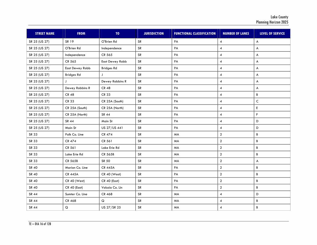
SR 25 (US 27) Polk Co. Line CR 474 SR PA 4 B
SR 25 (US 27) CR 474 A SR PA 4 B
SR 25 (US 27) A B SR PA 4 B
SR 25 (US 27) B Shell Pond Rd SR PA 4 B
SR 25 (US 27) Shell Pond Rd Lake Louisa Rd SR PA 4 B
SR 25 (US 27) Lake Louisa Rd Hartwood Marsh SR PA 4 B
SR 25 (US 27) Hartwood Marsh Hammock Rd SR PA 4 B
SR 25 (US 27) Hammock Rd Johns Lake Rd SR PA 4 B
SR 25 (US 27) Johns Lake Rd Anderson Hill R SR PA 4 B
SR 25 (US 27) Anderson Hill R Hook St SR PA 4 B
SR 25 (US 27) Hook St SR 50 SR PA 4 D
SR 25 (US 27) SR 50 Mohawk Rd SR PA 4 B
SR 25 (US 27) Mohawk Rd CR 50 SR PA 4 B
SR 25 (US 27) CR 50 CR 561A SR PA 4 C
SR 25 (US 27) CR 561A Sullivan Rd SR PA 4 B
SR 25 (US 27) Sullivan Rd CR 561 SR PA 4 B
SR 25 (US 27) CR 561 Libby Rd SR PA 4 B
SR 25 (US 27) Libby Rd SR 19 SR PA 4 A
Lake County Planning Horizon 2025
TE – DIA 16 of 128
STREET NAME FROM TO JURISDICTION FUNCTIONAL CLASSIFICATION NUMBER OF LANES LEVEL OF SERVICE
SR 25 (US 27) SR 19 O'Brien Rd SR PA 4 A
SR 25 (US 27) O'Brien Rd Independence SR PA 4 A
SR 25 (US 27) Independence CR 565 SR PA 4 A
SR 25 (US 27) CR 565 East Dewey Robb SR PA 4 A
SR 25 (US 27) East Dewey Robb Bridges Rd SR PA 4 A
SR 25 (US 27) Bridges Rd J SR PA 4 A
SR 25 (US 27) J Dewey Robbins R SR PA 4 A
SR 25 (US 27) Dewey Robbins R CR 48 SR PA 4 A
SR 25 (US 27) CR 48 CR 33 SR PA 4 B
SR 25 (US 27) CR 33 CR 25A (South) SR PA 4 C
SR 25 (US 27) CR 25A (South) CR 25A (North) SR PA 4 E
SR 25 (US 27) CR 25A (North) SR 44 SR PA 4 F
SR 25 (US 27) SR 44 Main St SR PA 4 D
SR 25 (US 27) Main St US 27/US 441 SR PA 4 D
SR 33 Polk Co. Line CR 474 SR MA 2 B
SR 33 CR 474 CR 561 SR MA 2 B
SR 33 CR 561 Lake Erie Rd SR MA 2 B
SR 33 Lake Erie Rd CR 565B SR MA 2 B
SR 33 CR 565B SR 50 SR MA 2 A
SR 40 Marion Co. Line CR 445A SR PA 2 B
SR 40 CR 445A CR 40 (West) SR PA 2 B
SR 40 CR 40 (West) CR 40 (East) SR PA 2 B
SR 40 CR 40 (East) Volusia Co. Lin SR PA 2 B
SR 44 Sumter Co. Line CR 468 SR MA 4 D
SR 44 CR 468 Q SR MA 4 B
SR 44 Q US 27/SR 25 SR MA 4 B
Transportation Element Data Inventory Analysis
TE – DIA 17 of 128
STREET NAME FROM TO JURISDICTION FUNCTIONAL CLASSIFICATION NUMBER OF LANES LEVEL OF SERVICE
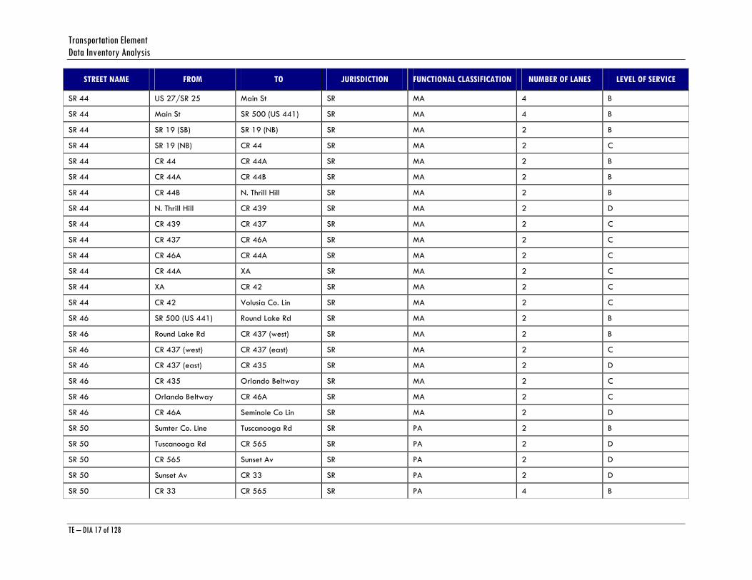
SR 44 US 27/SR 25 Main St SR MA 4 B
SR 44 Main St SR 500 (US 441) SR MA 4 B
SR 44 SR 19 (SB) SR 19 (NB) SR MA 2 B
SR 44 SR 19 (NB) CR 44 SR MA 2 C
SR 44 CR 44 CR 44A SR MA 2 B
SR 44 CR 44A CR 44B SR MA 2 B
SR 44 CR 44B N. Thrill Hill SR MA 2 B
SR 44 N. Thrill Hill CR 439 SR MA 2 D
SR 44 CR 439 CR 437 SR MA 2 C
SR 44 CR 437 CR 46A SR MA 2 C
SR 44 CR 46A CR 44A SR MA 2 C
SR 44 CR 44A XA SR MA 2 C
SR 44 XA CR 42 SR MA 2 C
SR 44 CR 42 Volusia Co. Lin SR MA 2 C
SR 46 SR 500 (US 441) Round Lake Rd SR MA 2 B
SR 46 Round Lake Rd CR 437 (west) SR MA 2 B
SR 46 CR 437 (west) CR 437 (east) SR MA 2 C
SR 46 CR 437 (east) CR 435 SR MA 2 D
SR 46 CR 435 Orlando Beltway SR MA 2 C
SR 46 Orlando Beltway CR 46A SR MA 2 C
SR 46 CR 46A Seminole Co Lin SR MA 2 D
SR 50 Sumter Co. Line Tuscanooga Rd SR PA 2 B
SR 50 Tuscanooga Rd CR 565 SR PA 2 D
SR 50 CR 565 Sunset Av SR PA 2 D
SR 50 Sunset Av CR 33 SR PA 2 D
SR 50 CR 33 CR 565 SR PA 4 B

Lake County Planning Horizon 2025
TE – DIA 18 of 128
STREET NAME FROM TO JURISDICTION FUNCTIONAL CLASSIFICATION NUMBER OF LANES LEVEL OF SERVICE
SR 50 CR 565 Ivey St SR PA 4 B
SR 50 EB Ivey St SR 19 SR PA 2 C
SR 50 EB SR 19 SR 33 SR PA 2 C
SR 50 WB SR 33 SR 19 SR PA 2 C
SR 50 WB SR 19 Ivey St SR PA 2 C
SR 50 SR 33 CR 565A SR PA 4 B
SR 50 CR 565A (west) CR 565A (east) SR PA 4 A
SR 50 CR 565A (east) CR 561 SR PA 4 B
SR 50 CR 561 SR 25 SR PA 4 C
SR 50 SR 25 Grand Highway SR PA 4 F
SR 50 Grand Highway Jacks Lake Rd SR PA 4 F
SR 50 Jacks Lake Rd Hancock Rd SR PA 4 F
SR 50 Hancock Rd CR 455 SR PA 4 F
SR 50 CR 455 Orange Co. Line SR PA 4 F
SR 91 Orange Co. Line Sullivan Rd SR PA 4 B
SR 91 Sullivan Rd SR 19 SR PA 4 B
SR 91 SR 19 CR 470 SR PA 4 B
SR 91 CR 470 Sumter Co. Line SR PA 4 B
US 27/US 441 SR 27/SR 25(@HI CR 466A SR PA 6 F
US 27/US 441 CR 466A CR 460 SR PA 6 F
US 27/US 441 CR 460 CR 25A (South) SR PA 6 F
US 27/US 441 CR 25A (South) CR 466A SR PA 4 F
US 27/US 441 CR 466A CR 25A (North) SR PA 4 B
US 27/US 441 CR 25A (North) Spring Lake Rd SR PA 4 B
US 27/US 441 Spring Lake Rd Grays Airport R SR PA 4 B
US 27/US 441 Grays Airport R Eaglesnest Rd SR PA 4 B
Transportation Element Data Inventory Analysis
TE – DIA 19 of 128
STREET NAME FROM TO JURISDICTION FUNCTIONAL CLASSIFICATION NUMBER OF LANES LEVEL OF SERVICE
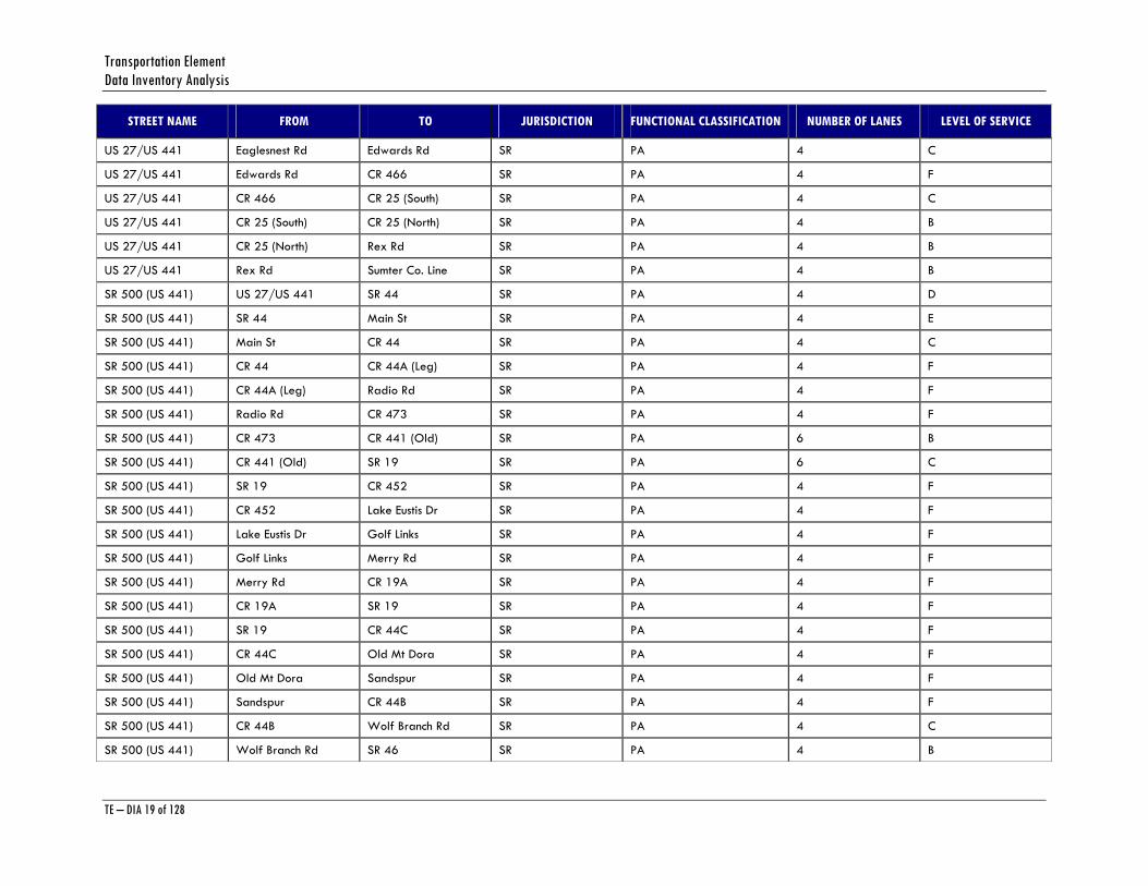
US 27/US 441 Eaglesnest Rd Edwards Rd SR PA 4 C
US 27/US 441 Edwards Rd CR 466 SR PA 4 F
US 27/US 441 CR 466 CR 25 (South) SR PA 4 C
US 27/US 441 CR 25 (South) CR 25 (North) SR PA 4 B
US 27/US 441 CR 25 (North) Rex Rd SR PA 4 B
US 27/US 441 Rex Rd Sumter Co. Line SR PA 4 B
SR 500 (US 441) US 27/US 441 SR 44 SR PA 4 D
SR 500 (US 441) SR 44 Main St SR PA 4 E
SR 500 (US 441) Main St CR 44 SR PA 4 C
SR 500 (US 441) CR 44 CR 44A (Leg) SR PA 4 F
SR 500 (US 441) CR 44A (Leg) Radio Rd SR PA 4 F
SR 500 (US 441) Radio Rd CR 473 SR PA 4 F
SR 500 (US 441) CR 473 CR 441 (Old) SR PA 6 B
SR 500 (US 441) CR 441 (Old) SR 19 SR PA 6 C
SR 500 (US 441) SR 19 CR 452 SR PA 4 F
SR 500 (US 441) CR 452 Lake Eustis Dr SR PA 4 F
SR 500 (US 441) Lake Eustis Dr Golf Links SR PA 4 F
SR 500 (US 441) Golf Links Merry Rd SR PA 4 F
SR 500 (US 441) Merry Rd CR 19A SR PA 4 F
SR 500 (US 441) CR 19A SR 19 SR PA 4 F
SR 500 (US 441) SR 19 CR 44C SR PA 4 F
SR 500 (US 441) CR 44C Old Mt Dora SR PA 4 F
SR 500 (US 441) Old Mt Dora Sandspur SR PA 4 F
SR 500 (US 441) Sandspur CR 44B SR PA 4 F
SR 500 (US 441) CR 44B Wolf Branch Rd SR PA 4 C
SR 500 (US 441) Wolf Branch Rd SR 46 SR PA 4 B

Lake County Planning Horizon 2025
TE – DIA 20 of 128
STREET NAME FROM TO JURISDICTION FUNCTIONAL CLASSIFICATION NUMBER OF LANES LEVEL OF SERVICE
SR 500 (US 441) SR 46 Orange Co. Line SR PA 4 B
SR 530 (US 192) SR 25 Orange Co. Line SR MA 4 B
Key:
Jurisdiction: CR = County Road, SR = State Road
Functional Classification: C = Collector, MA = Minor Arterial, PA = Principal Arterial
AADT = Annual Average Daily Traffic
Source: Lake County Public Works and FDOT Florida Traffic Information
Transportation Element Data Inventory Analysis
TE – DIA 21 of 128
PROGRAMMED ROADWAY IMPROVEMENTS
Both the State and Lake County have roadway improvements programmed to alleviate existing deficiencies in the central part of the County.
On the State side, US 441 is programmed for six-laning through 2010. Additionally, improvements are also scheduled for SR 50 in the Clermont area and US 27 from the Polk County line to the Turnpike. The Turnpike District of FDOT has a new interchange on Florida’s Turnpike at CR 470. This new interchange provides nearby access to Florida’s Turnpike for residents of Leesburg and Tavares, and therefore makes the Turnpike a viable alternative for travel between Leesburg and the Orlando metropolitan area.
The Lake County Construction Program for 2005-2009 is shown in Appendix A. The program outlines transportation projects scheduled for the next five years that are either funded by impact fees, the transportation trust fund or sales tax funds from the voter-approved one-cent sales tax referendum. The majority of the projects slated to begin construction in 2006 occur in the impact fee portion of the program. Of the 73 projects outlined in the impact fee assessment portion of the five-year program, 28 are scheduled to begin construction in 2006. Of the 28 impact-fee projects programmed for construction in 2006 some of the larger projects include:
• Widening Old Mount Dora Road from U.S. Highway 441 to State Road 19 • Constructing a new 24-foot road that connects Woodlea Road to Dead River Road • Constructing a new four-lane road, referred to as the South Lake Connector, from Lakeshore
Drive to Citrus Tower Boulevard • Constructing a new two-lane road from U.S. Highway 27 to Citrus Tower Boulevard • Improving the intersections of State Road 44 and Sleepy Hollow Road at U.S. Highway 441 • Constructing two new four-lane roads, referred as Hooks Street Extension phases III and IV,
from 3,300 west of Citrus Tower Boulevard to Citrus Tower Boulevard and from U.S. Highway 27 to Hooks Street phase II.
The Five Year Transportation Improvement Program (TIP) for state and U.S. highways is shown in Appendix B. The TIP was developed with the Florida Department of Transportation and based on Lake-Sumter MPO needs. It must be financially feasible, and identify all federal and state transportation needs.
FUTURE ROADWAY CONDITIONS
As part of the development of the Lake County 2025 Transportation Plan, an updated Lake County Transportation Study (LCTS) was developed, which included the latest future land use information, as well as programmed roadway improvements. The LCTS is based upon a computer-based traffic model (FSUTMS) designed to forecast future traffic levels and traffic assignments in Lake County. The LCTS developed for the Lake County 2025 Transportation Plan has a horizon year of 2025. The Lake-Sumter MPO is currently updating this plan to the year 2025.
Using the existing roadway network with programmed improvements, a determination of future year roadway operating conditions was completed, and roads with future year operating deficiencies were identified. Based on this analysis, a plan of road improvements was developed
Lake County Planning Horizon 2025
TE – DIA 22 of 128
to alleviate forecasted congestion to the greatest extent possible. This list of improvements has been incorporated into the Capital Improvements Element. Funding for many of these improvements has been identified through State and County sources. The remaining improvements will be programmed as additional funds are identified and committed.
Major projects contained in the highway improvements plan include:
Table 4 - Summary of Improvements
SR 19 Improve from two to four lanes from CR 450 to CR 42.
SR 19 Improve from 4 to 6 lanes from SR 500 (US 441) to SR19 one-way pair.
SR 50 Improve from 2 to 4 lanes from Sumter County line to CR 33.
SR 50 Improve from 4 to 6 lanes from SR 25 (US 27) to Orange County line.
SR 25 (US 27) Improve from 4 to 6 lanes from Polk County line to Turnpike.
CR 44 Improve from 2 to 4 lanes from CR 473 to CR 452
CR 44 Improve from 2 to 4 lanes from CR 452 to SR 44.
Hartwood Marsh Road Improve from 2 to 4 lanes.
CR 466 and 466 A Improve from 2 to 4 lanes.
CR 470/CR 48 Improve from 2 to 4 lanes from Sumter County Line to east side of US 27.
Most of these projects are designed to relieve existing or forecast congestion on the roadway proposed for improvement.
Future Year Roadway Operating Conditions
An analysis of future year roadway operations for the network including all recommended improvements was completed as part of the development of the Needs Plan of the 2025 Long Range Transportation Plan. Levels of service for all roads are within acceptable limits, although some road segments will operate at level of service E or F in the 2025 LRTP Needs Plan. These roads include:
4. SR 19 in downtown Eustis and south of US 441
5. Sections of Old 441 between SR 19 and SR 46
6. US 27/US 441 between Grays Airport Road and Eaglesnest Road
7. Main Street in Leesburg from SR 44 to US 27
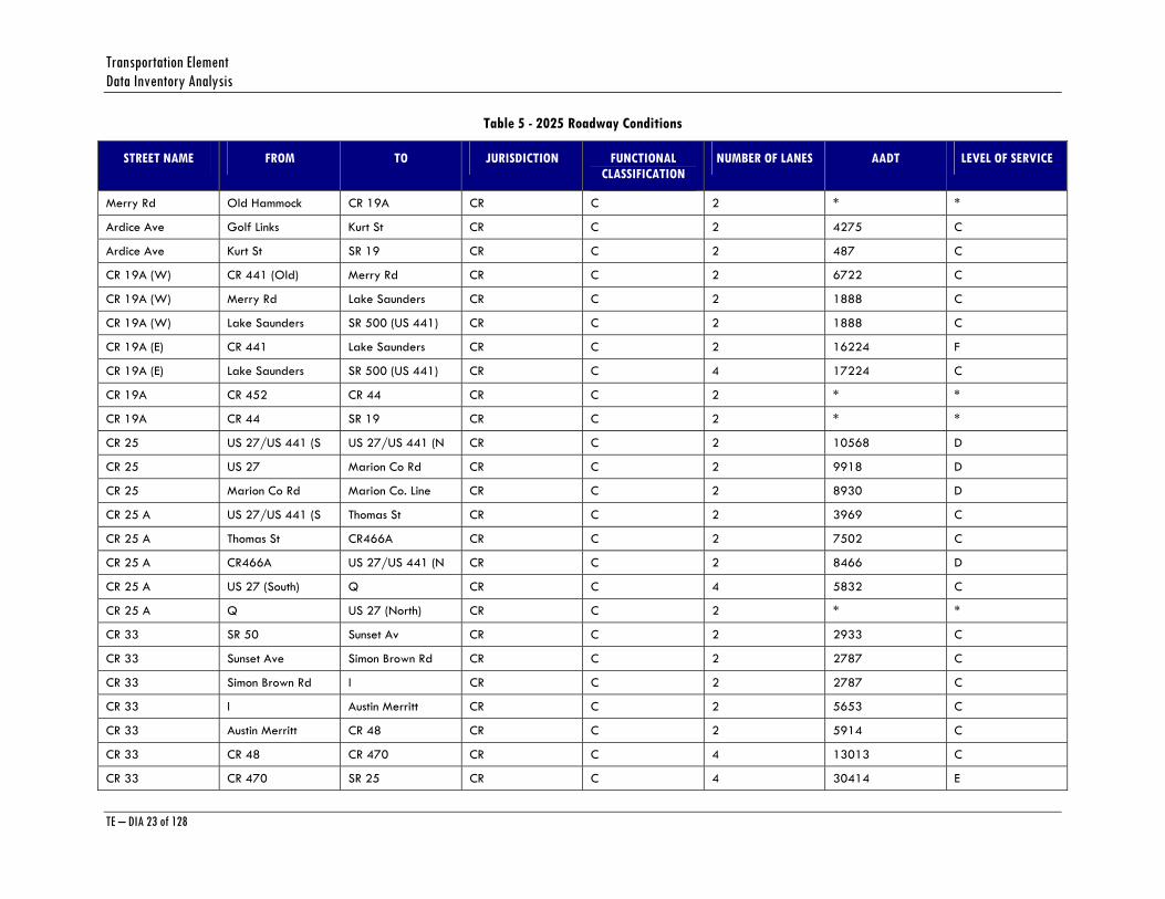
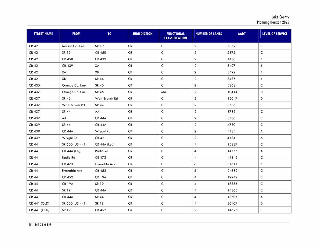
The Table below lists the 2025 Future Year Roadway Operating Conditions:
Transportation Element Data Inventory Analysis
TE – DIA 23 of 128
Table 5 - 2025 Roadway Conditions
STREET NAME FROM TO JURISDICTION FUNCTIONAL CLASSIFICATION
NUMBER OF LANES AADT LEVEL OF SERVICE
Merry Rd Old Hammock CR 19A CR C 2 * *
Ardice Ave Golf Links Kurt St CR C 2 4275 C
Ardice Ave Kurt St SR 19 CR C 2 487 C
CR 19A (W) CR 441 (Old) Merry Rd CR C 2 6722 C
CR 19A (W) Merry Rd Lake Saunders CR C 2 1888 C
CR 19A (W) Lake Saunders SR 500 (US 441) CR C 2 1888 C
CR 19A (E) CR 441 Lake Saunders CR C 2 16224 F
CR 19A (E) Lake Saunders SR 500 (US 441) CR C 4 17224 C
CR 19A CR 452 CR 44 CR C 2 * *
CR 19A CR 44 SR 19 CR C 2 * *
CR 25 US 27/US 441 (S US 27/US 441 (N CR C 2 10568 D
CR 25 US 27 Marion Co Rd CR C 2 9918 D
CR 25 Marion Co Rd Marion Co. Line CR C 2 8930 D
CR 25 A US 27/US 441 (S Thomas St CR C 2 3969 C
CR 25 A Thomas St CR466A CR C 2 7502 C
CR 25 A CR466A US 27/US 441 (N CR C 2 8466 D
CR 25 A US 27 (South) Q CR C 4 5832 C
CR 25 A Q US 27 (North) CR C 2 * *
CR 33 SR 50 Sunset Av CR C 2 2933 C
CR 33 Sunset Ave Simon Brown Rd CR C 2 2787 C
CR 33 Simon Brown Rd I CR C 2 2787 C
CR 33 I Austin Merritt CR C 2 5653 C
CR 33 Austin Merritt CR 48 CR C 2 5914 C
CR 33 CR 48 CR 470 CR C 4 13013 C
CR 33 CR 470 SR 25 CR C 4 30414 E
Lake County Planning Horizon 2025
TE – DIA 24 of 128
STREET NAME FROM TO JURISDICTION FUNCTIONAL CLASSIFICATION
NUMBER OF LANES AADT LEVEL OF SERVICE
CR 42 Marion Co. Line SR 19 CR C 2 5352 C
CR 42 SR 19 CR 450 CR C 2 5375 C
CR 42 CR 450 CR 439 CR C 2 4436 B
CR 42 CR 439 XA CR C 2 3497 B
CR 42 XA XB CR C 2 3492 B
CR 42 XB SR 44 CR C 2 3487 B
CR 435 Orange Co. Line SR 46 CR C 2 5868 C
CR 437 Orange Co. Line SR 46 CR MA 2 10414 D
CR 437 SR 46 Wolf Branch Rd CR C 2 12047 D
CR 437 Wolf Branch Rd SR 44 CR C 2 8786 C
CR 437 SR 44 AA CR C 2 8786 C
CR 437 AA CR 44A CR C 2 8786 C
CR 439 SR 44 CR 44A CR C 2 4730 C
CR 439 CR 44A Wiygul Rd CR C 2 4184 A
CR 439 Wiygul Rd CR 42 CR C 2 4184 A
CR 44 SR 500 (US 441) CR 44A (Leg) CR C 4 15337 C
CR 44 CR 44A (Leg) Radio Rd CR C 4 14557 A
CR 44 Radio Rd CR 473 CR C 4 41842 C
CR 44 CR 473 Emeralda Ave CR C 6 31611 B
CR 44 Emeralda Ave CR 452 CR C 6 24832 C
CR 44 CR 452 CR 19A CR C 4 19942 C
CR 44 CR 19A SR 19 CR C 4 18366 C
CR 44 SR 19 CR 44A CR C 4 14365 C
CR 44 CR 44A SR 44 CR C 4 13705 A
CR 441 (OLD) SR 500 (US 441) SR 19 CR C 4 26407 D
CR 441 (OLD) SR 19 CR 452 CR C 2 14625 F
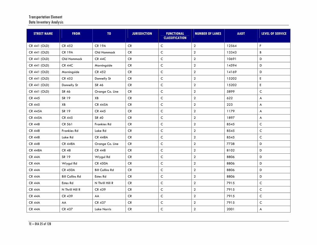
Transportation Element Data Inventory Analysis
TE – DIA 25 of 128
STREET NAME FROM TO JURISDICTION FUNCTIONAL CLASSIFICATION
NUMBER OF LANES AADT LEVEL OF SERVICE
CR 441 (OLD) CR 452 CR 19A CR C 2 12564 F
CR 441 (OLD) CR 19A Old Hammock CR C 2 13343 B
CR 441 (OLD) Old Hammock CR 44C CR C 2 10691 D
CR 441 (OLD) CR 44C Morningside CR C 2 14594 D
CR 441 (OLD) Morningside CR 452 CR C 2 14169 D
CR 441 (OLD) CR 452 Donnelly St CR C 2 15202 E
CR 441 (OLD) Donnelly St SR 46 CR C 2 15202 E
CR 441 (OLD) SR 46 Orange Co. Line CR C 2 5899 C
CR 445 SR 19 XB CR C 2 622 A
CR 445 XB CR 445A CR C 2 223 A
CR 445A SR 19 CR 445 CR C 2 1179 A
CR 445A CR 445 SR 40 CR C 2 1897 A
CR 448 CR 561 Frankies Rd CR C 2 8545 C
CR 448 Frankies Rd Lake Rd CR C 2 8545 C
CR 448 Lake Rd CR 448A CR C 2 8545 C
CR 448 CR 448A Orange Co. Line CR C 2 7738 D
CR 448A CR 48 CR 448 CR C 2 8102 D
CR 44A SR 19 Wiygul Rd CR C 2 8806 D
CR 44A Wiygul Rd CR 450A CR C 2 8806 D
CR 44A CR 450A Bill Collins Rd CR C 2 8806 D
CR 44A Bill Collins Rd Estes Rd CR C 2 8806 D
CR 44A Estes Rd N Thrill Hill R CR C 2 7915 C
CR 44A N Thrill Hill R CR 439 CR C 2 7915 C
CR 44A CR 439 AA CR C 2 7915 C
CR 44A AA CR 437 CR C 2 7915 C
CR 44A CR 437 Lake Norris CR C 2 2001 A

Lake County Planning Horizon 2025
TE – DIA 26 of 128
STREET NAME FROM TO JURISDICTION FUNCTIONAL CLASSIFICATION
NUMBER OF LANES AADT LEVEL OF SERVICE
CR 44A Lake Norris SR 44 CR C 2 2001 A
CR 44A Thomas Av US 27/US 441 CR C 2 11089 D
CR 44A (Leg) CR 44 SR 500 (US 441) CR C 4 * *
CR 44A (Leg) CR 44 CR 44A CR C 2 3963 C
CR 44B US 441 SR 44 CR C 4 16578 C
CR 44C CR 441 (Old) SR 500 (US 441) CR C 2 13753 D
CR 44C CR 468 Thomas Av CR C 2 6620 C
CR 450 Marion Co. Line SR 19 CR C 2 2932 B
CR 450 SR 19 CR 42 CR C 2 3963 B
CR 450A SR 19 CR 44A CR C 2 1512 A
CR 452 SR 19 (North) CR 19A CR C 4 17630 C
CR 452 CR 19A CR 44 CR C 4 12419 C
CR 452 CR 44 Goose Prairie Rd CR C 2 6645 B
CR 452 Goose Prairie Rd Felkins Rd CR C 2 8469 B
CR 452 Felkins Rd Marion Co. Line CR C 2 7204 C
CR 452 SR 500 (US 441) CR 441 CR C 2 12510 F
CR 452 CR 441 Main St CR C 2 6150 C
CR 452 Main St Dora Ave CR C 2 2227 C
CR 452 Dora Av CR 441 (Old) CR C 2 1775 A
CR 455 SR 50 CR 50 CR C 2 3389 C
CR 455 CR 50 (S) CR 50 (N) CR C 2 4667 C
CR 455 CR 50 (N) Ridgewood Ave CR C 2 6485 C
CR 455 Ridgewood Ave Fosgate CR C 2 5739 C
CR 455 Fosgate CR 561A CR C 2 4801 C
CR 455 CR 561A M CR C 2 3234 C
CR 455 M Fosgate CR C 2 3234 C

Transportation Element Data Inventory Analysis
TE – DIA 27 of 128
STREET NAME FROM TO JURISDICTION FUNCTIONAL CLASSIFICATION
NUMBER OF LANES AADT LEVEL OF SERVICE
CR 455 Fosgate CR 561 CR C 2 2382 B
CR 455 CR 561 SR 19 CR C 2 2132 B
CR 46 CR 441 (Old) SR 500 (US 441) CR MA 2 9714 B
CR 460 CR 468 Thomas Av CR C 4 4146 C
CR 460 Thomas Av US 27/US 441 CR C 4 4146 C
CR 466 Sumter Co. Line Rex Rd CR C 4 12333 C
CR 466 Rex Rd US 27/US 441 CR C 4 21801 C
CR 466 A Sumter Co. Line Micro Racetrack CR C 2 4842 B
CR 466 A Micro Racetrack Spring Lake Rd CR C 2 4842 B
CR 466 A Spring Lake Rd CR 468 CR C 2 5944 C
CR 466 A CR 468 CR 25A CR C 2 7768 C
CR 466 A CR 25A US 27/US 441 CR C 2 5221 A
CR 466 A US 27/US 441 CR 466B CR C 2 14036 F
CR 466B CR 466A Eaglesnest Rd CR C 2 11890 F
CR 468 SR 44 CR 44C CR C 4 9437 A
CR 468 CR 44C CR 460 CR C 2 7546 A
CR 468 CR 460 CR 466A CR C 2 3473 C
CR 46A SR 44 Orlando Beltway CR C 4 6487 A
CR 46A Orlando Beltway SR 46 CR C 4 6487 A
CR 470 Sumter Co. Line SR 91 CR C 2 11973 D
CR 470 SR 91 CR 33 CR C 4 22513 C
CR 473 SR 500 Bell Rd CR C 4 12287 C
CR 473 Bell Rd Treadway School CR C 4 5342 C
CR 473 Treadway School CR 44 CR C 2 7162 B
CR 474 SR 33 SR 25 CR C 2 3258 B
CR 48 Sumter Co. Line North Austin Me CR C 2 7262 C
Lake County Planning Horizon 2025
TE – DIA 28 of 128
STREET NAME FROM TO JURISDICTION FUNCTIONAL CLASSIFICATION
NUMBER OF LANES AADT LEVEL OF SERVICE
CR 48 North Austin Me CR 33 CR C 2 7359 C
CR 48 CR 33 SR 25 CR C 4 13767 C
CR 48 SR 25 Number Two Rd CR C 4 10951 A
CR 48 Number Two Rd SR 19 CR C 2 8646 D
CR 48 CR 561 Daque Lake CR C 2 4633 C
CR 48 Daque Lake CR 448A CR C 2 6081 C
CR 50 CR 455 Orange Co. Line CR C 2 4435 C
CR 50 SR 25 Jacks Lake Rd CR C 2 5448 C
CR 50 Jacks Lake Rd Turkey Farms Rd CR C 2 5200 C
CR 50 Turkey Farms Rd Blackstill Lake CR C 2 5200 C
CR 50 Blackstill Lake CR 455 CR C 2 2960 C
CR 561 SR 33 Lakeshore Dr CR C 2 1282 A
CR 561 Lakeshore Dr CR 565B CR C 2 2890 C
CR 561 CR 565B SR 50 CR C 2 2890 C
CR 561 US 27 CR 561A CR C 2 11594 D
CR 561 CR 561A Sugarloaf Mt Rd CR C 2 9733 D
CR 561 Sugarloaf Mt Rd K CR C 2 9733 D
CR 561 K Sullivan Rd CR C 2 9733 D
CR 561 Sullivan Rd CR 455 CR C 2 9145 D
CR 561 CR 455 CR 48 CR C 2 11428 D
CR 561 CR 48 Frankies Rd CR C 2 11435 D
CR 561 Frankies Rd CR 448 CR C 2 11435 D
CR 561 CR 448 O CR C 2 13856 D
CR 561 O SR 19 CR C 2 13856 D
CR 561A SR 50 CR 565A CR C 2 2792 C
CR 561A CR 565A Jalarmy CR C 2 5472 C
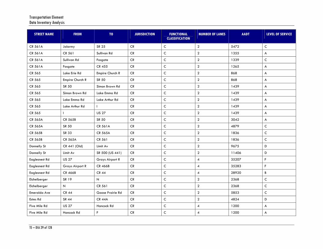
Transportation Element Data Inventory Analysis
TE – DIA 29 of 128
STREET NAME FROM TO JURISDICTION FUNCTIONAL CLASSIFICATION
NUMBER OF LANES AADT LEVEL OF SERVICE
CR 561A Jalarmy SR 25 CR C 2 5472 C
CR 561A CR 561 Sullivan Rd CR C 2 1355 A
CR 561A Sullivan Rd Fosgate CR C 2 1339 C
CR 561A Fosgate CR 455 CR C 2 1265 A
CR 565 Lake Erie Rd Empire Church R CR C 2 868 A
CR 565 Empire Church R SR 50 CR C 2 868 A
CR 565 SR 50 Simon Brown Rd CR C 2 1439 A
CR 565 Simon Brown Rd Lake Emma Rd CR C 2 1439 A
CR 565 Lake Emma Rd Lake Arthur Rd CR C 2 1439 A
CR 565 Lake Arthur Rd I CR C 2 1439 A
CR 565 I US 27 CR C 2 1439 A
CR 565A CR 565B SR 50 CR C 2 3042 A
CR 565A SR 50 CR 561A CR C 2 4879 C
CR 565B SR 33 CR 565A CR C 2 1836 C
CR 565B CR 565A CR 561 CR C 2 1836 C
Donnelly St CR 441 (Old) Limit Av CR C 2 9675 D
Donnelly St Limit Av SR 500 (US 441) CR C 2 11406 D
Eaglesnest Rd US 27 Grays Airport R CR C 4 35207 F
Eaglesnest Rd Grays Airport R CR 466B CR C 4 35283 F
Eaglesnest Rd CR 466B CR 44 CR C 4 28920 B
Eichelberger SR 19 N CR C 2 2368 C
Eichelberger N CR 561 CR C 2 2368 C
Emeralda Ave CR 44 Goose Prairie Rd CR C 2 5853 C
Estes Rd SR 44 CR 44A CR C 2 4824 D
Five Mile Rd US 27 Hancock Rd CR C 4 1200 A
Five Mile Rd Hancock Rd F CR C 4 1200 A
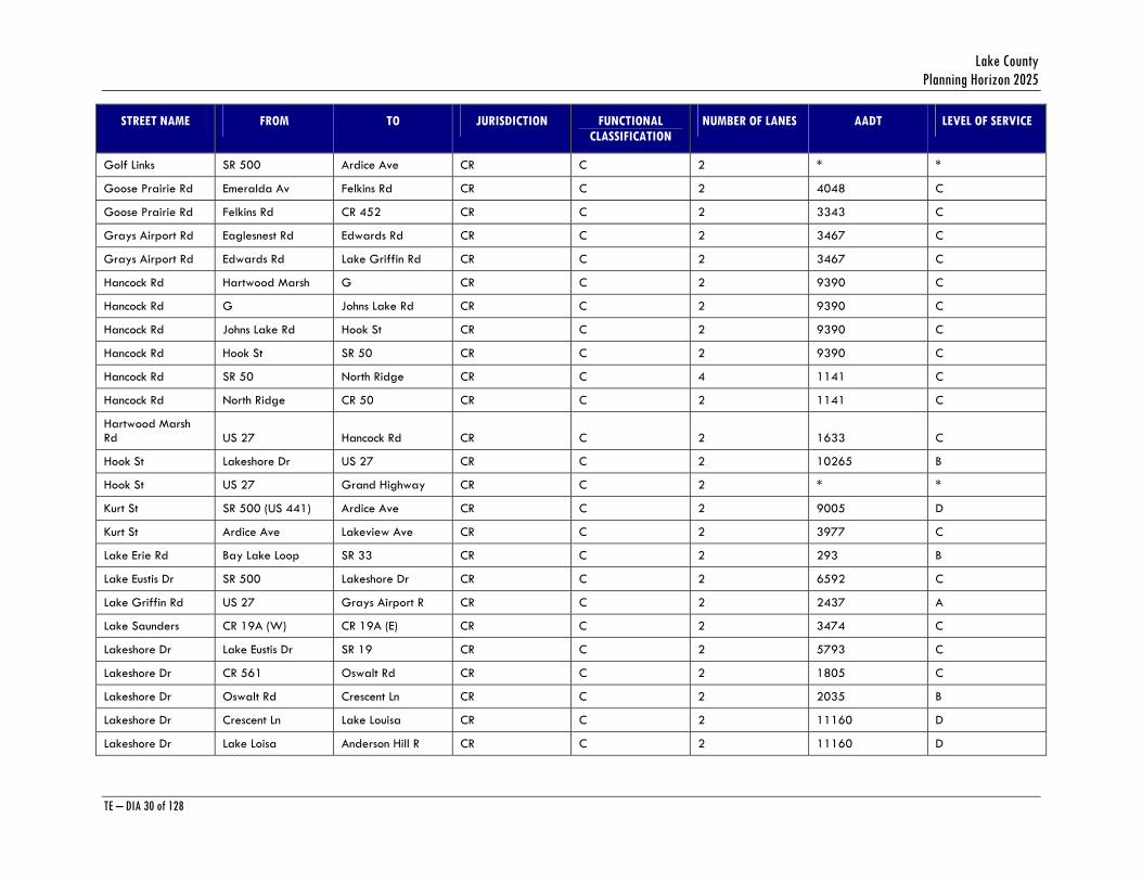
Lake County Planning Horizon 2025
TE – DIA 30 of 128
STREET NAME FROM TO JURISDICTION FUNCTIONAL CLASSIFICATION
NUMBER OF LANES AADT LEVEL OF SERVICE
Golf Links SR 500 Ardice Ave CR C 2 * *
Goose Prairie Rd Emeralda Av Felkins Rd CR C 2 4048 C
Goose Prairie Rd Felkins Rd CR 452 CR C 2 3343 C
Grays Airport Rd Eaglesnest Rd Edwards Rd CR C 2 3467 C
Grays Airport Rd Edwards Rd Lake Griffin Rd CR C 2 3467 C
Hancock Rd Hartwood Marsh G CR C 2 9390 C
Hancock Rd G Johns Lake Rd CR C 2 9390 C
Hancock Rd Johns Lake Rd Hook St CR C 2 9390 C
Hancock Rd Hook St SR 50 CR C 2 9390 C
Hancock Rd SR 50 North Ridge CR C 4 1141 C
Hancock Rd North Ridge CR 50 CR C 2 1141 C
Hartwood Marsh Rd US 27 Hancock Rd CR C 2 1633 C
Hook St Lakeshore Dr US 27 CR C 2 10265 B
Hook St US 27 Grand Highway CR C 2 * *
Kurt St SR 500 (US 441) Ardice Ave CR C 2 9005 D
Kurt St Ardice Ave Lakeview Ave CR C 2 3977 C
Lake Erie Rd Bay Lake Loop SR 33 CR C 2 293 B
Lake Eustis Dr SR 500 Lakeshore Dr CR C 2 6592 C
Lake Griffin Rd US 27 Grays Airport R CR C 2 2437 A
Lake Saunders CR 19A (W) CR 19A (E) CR C 2 3474 C
Lakeshore Dr Lake Eustis Dr SR 19 CR C 2 5793 C
Lakeshore Dr CR 561 Oswalt Rd CR C 2 1805 C
Lakeshore Dr Oswalt Rd Crescent Ln CR C 2 2035 B
Lakeshore Dr Crescent Ln Lake Louisa CR C 2 11160 D
Lakeshore Dr Lake Loisa Anderson Hill R CR C 2 11160 D
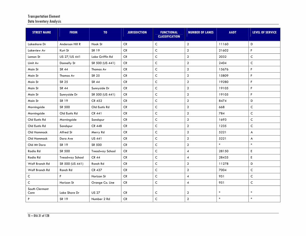
Transportation Element Data Inventory Analysis
TE – DIA 31 of 128
STREET NAME FROM TO JURISDICTION FUNCTIONAL CLASSIFICATION
NUMBER OF LANES AADT LEVEL OF SERVICE
Lakeshore Dr Anderson Hill R Hook St CR C 2 11160 D
Lakeview Av Kurt St SR 19 CR C 2 21602 F
Lemon St US 27/US 441 Lake Griffin Rd CR C 2 2032 C
Limit Av Donnelly St SR 500 (US 441) CR C 2 2404 C
Main St SR 44 Thomas Av CR C 2 15676 F
Main St Thomas Av SR 25 CR C 2 15809 F
Main St SR 25 SR 44 CR C 2 19280 F
Main St SR 44 Sunnyside Dr CR C 2 19105 F
Main St Sunnyside Dr SR 500 (US 441) CR C 2 19105 F
Main St SR 19 CR 452 CR C 2 8474 D
Morningside SR 500 Old Eustis Rd CR C 2 668 C
Morningside Old Eustis Rd CR 441 CR C 2 784 C
Old Eustis Rd Morningside Sandspur CR C 2 1693 C
Old Eustis Rd Sandspur CR 44B CR C 2 1235 C
Old Hammock Alfred St Merry Rd CR C 2 5221 A
Old Hammock Dora Ave US 441 CR C 2 5221 A
Old Mt Dora SR 19 SR 500 CR C 2 * *
Radio Rd SR 500 Treadway School CR C 4 28150 E
Radio Rd Treadway School CR 44 CR C 4 28435 E
Wolf Branch Rd SR 500 (US 441) Ranch Rd CR C 2 11278 D
Wolf Branch Rd Ranch Rd CR 437 CR C 2 7004 C
C F Horizon St CR C 4 951 C
C Horizon St Orange Co. Line CR C 4 951 C
South Clermont Conn Lake Shore Dr US 27 CR C 2 * *
P SR 19 Number 2 Rd CR C 2 * *
Lake County Planning Horizon 2025
TE – DIA 32 of 128
STREET NAME FROM TO JURISDICTION FUNCTIONAL CLASSIFICATION
NUMBER OF LANES AADT LEVEL OF SERVICE
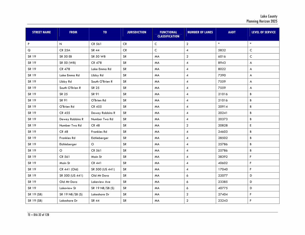
P N CR 561 CR C 2 * *
Q CR 25A SR 44 CR C 4 5832 C
SR 19 SR 50 EB SR 50 WB SR MA 2 6016 C
SR 19 SR 50 (WB) CR 478 SR MA 4 8943 A
SR 19 CR 478 Lake Emma Rd SR MA 4 8022 A
SR 19 Lake Emma Rd Libby Rd SR MA 4 7390 A
SR 19 Libby Rd South O'Brien R SR MA 4 7559 A
SR 19 South O'Brien R SR 25 SR MA 4 7559 A
SR 19 SR 25 SR 91 SR MA 4 21016 B
SR 19 SR 91 O'Brien Rd SR MA 4 21016 B
SR 19 O'Brien Rd CR 455 SR MA 4 20914 B
SR 19 CR 455 Dewey Robbins R SR MA 4 20241 B
SR 19 Dewey Robbins R Number Two Rd SR MA 4 20373 B
SR 19 Number Two Rd CR 48 SR MA 2 20828 E
SR 19 CR 48 Frankies Rd SR MA 4 24603 B
SR 19 Frankies Rd Eichleberger SR MA 4 28502 B
SR 19 Eichleberger O SR MA 4 25786 B
SR 19 O CR 561 SR MA 4 25786 B
SR 19 CR 561 Main St SR MA 4 38392 F
SR 19 Main St CR 441 SR MA 4 40602 F
SR 19 CR 441 (Old) SR 500 (US 441) SR MA 4 17040 F
SR 19 SR 500 (US 441) Old Mt Dora SR MA 6 22077 D
SR 19 Old Mt Dora Lakeview Ave SR MA 6 23385 D
SR 19 Lakeview St SR 19 NB/SB (S) SR MA 6 40775 D
SR 19 (SB) SR 19 NB/SB (S) Lakeshore Dr SR MA 2 27404 F
SR 19 (SB) Lakeshore Dr SR 44 SR MA 2 23243 F
Transportation Element Data Inventory Analysis
TE – DIA 33 of 128
STREET NAME FROM TO JURISDICTION FUNCTIONAL CLASSIFICATION
NUMBER OF LANES AADT LEVEL OF SERVICE
SR 19 (SB) SR 44 SR 19 NB/SB (N) SR MA 2 23045 F
SR 19 (NB) SR 19 NB/SB (S) SR 44 SR MA 2 19264 E
SR 19 (NB) SR 44 SR 19 NB/SB (N) SR MA 2 20538 E
SR 19 SR 19 NB/SB (N) CR 44 SR MA 4 20617 B
SR 19 CR 44 CR 19A SR MA 4 26195 B
SR 19 CR 19A CR 450A SR MA 4 26900 B
SR 19 CR 450A CR 44A SR MA 4 24334 B
SR 19 CR 44A CR 450 (South) SR MA 4 24134 B
SR 19 CR 450 (South) CR 450 (North) SR MA 4 19643 A
SR 19 CR 450 (North) CR 42 SR MA 4 15560 A
SR 19 CR 42 CR 445 SR MA 2 7087 C
SR 19 CR 445 CR 445A SR MA 2 5000 B
SR 19 CR 445A Marion Co. Line SR MA 2 5054 B
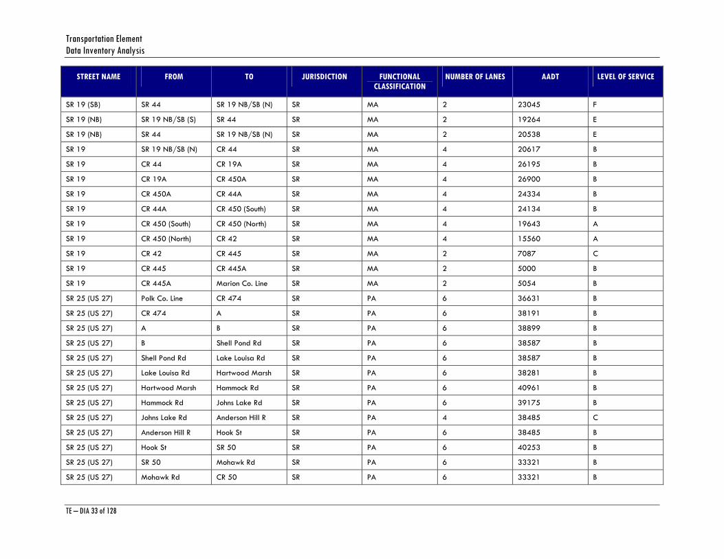
SR 25 (US 27) Polk Co. Line CR 474 SR PA 6 36631 B
SR 25 (US 27) CR 474 A SR PA 6 38191 B
SR 25 (US 27) A B SR PA 6 38899 B
SR 25 (US 27) B Shell Pond Rd SR PA 6 38587 B
SR 25 (US 27) Shell Pond Rd Lake Louisa Rd SR PA 6 38587 B
SR 25 (US 27) Lake Louisa Rd Hartwood Marsh SR PA 6 38281 B
SR 25 (US 27) Hartwood Marsh Hammock Rd SR PA 6 40961 B
SR 25 (US 27) Hammock Rd Johns Lake Rd SR PA 6 39175 B
SR 25 (US 27) Johns Lake Rd Anderson Hill R SR PA 4 38485 C
SR 25 (US 27) Anderson Hill R Hook St SR PA 6 38485 B
SR 25 (US 27) Hook St SR 50 SR PA 6 40253 B
SR 25 (US 27) SR 50 Mohawk Rd SR PA 6 33321 B
SR 25 (US 27) Mohawk Rd CR 50 SR PA 6 33321 B
Lake County Planning Horizon 2025
TE – DIA 34 of 128
STREET NAME FROM TO JURISDICTION FUNCTIONAL CLASSIFICATION
NUMBER OF LANES AADT LEVEL OF SERVICE
SR 25 (US 27) CR 50 CR 561A SR PA 6 31103 B
SR 25 (US 27) CR 561A Sullivan Rd SR PA 6 29654 A
SR 25 (US 27) Sullivan Rd CR 561 SR PA 6 29654 A
SR 25 (US 27) CR 561 Libby Rd SR PA 4 24865 B
SR 25 (US 27) Libby Rd SR 19 SR PA 4 25501 B
SR 25 (US 27) SR 19 O'Brien Rd SR PA 4 21595 B
SR 25 (US 27) O'Brien Rd Independence SR PA 4 21595 B
SR 25 (US 27) Independence CR 565 SR PA 4 21595 B
SR 25 (US 27) CR 565 East Dewey Robb SR PA 4 20581 B
SR 25 (US 27) East Dewey Robb Bridges Rd SR PA 4 17633 A
SR 25 (US 27) Bridges Rd J SR PA 4 17633 A
SR 25 (US 27) J Dewey Robbins R SR PA 4 17633 A
SR 25 (US 27) Dewey Robbins R CR 48 SR PA 4 17633 A
SR 25 (US 27) CR 48 CR 33 SR PA 4 22454 B
SR 25 (US 27) CR 33 CR 25A (South) SR PA 6 56985 F
SR 25 (US 27) CR 25A (South) CR 25A (North) SR PA 6 51875 F
SR 25 (US 27) CR 25A (North) SR 44 SR PA 4 53967 F
SR 25 (US 27) SR 44 Main St SR PA 4 41996 F
SR 25 (US 27) Main St US 27/US 441 SR PA 4 46424 F
SR 33 Polk Co. Line CR 474 SR MA 2 6808 C
SR 33 CR 474 CR 561 SR MA 2 6461 C
SR 33 CR 561 Lake Erie Rd SR MA 2 6152 C
SR 33 Lake Erie Rd CR 565B SR MA 2 6108 C
SR 33 CR 565B SR 50 SR MA 4 6845 A
SR 40 Marion Co. Line CR 445A SR PA 2 7534 C
SR 40 CR 445A CR 40 (West) SR PA 2 9869 D
Transportation Element Data Inventory Analysis
TE – DIA 35 of 128
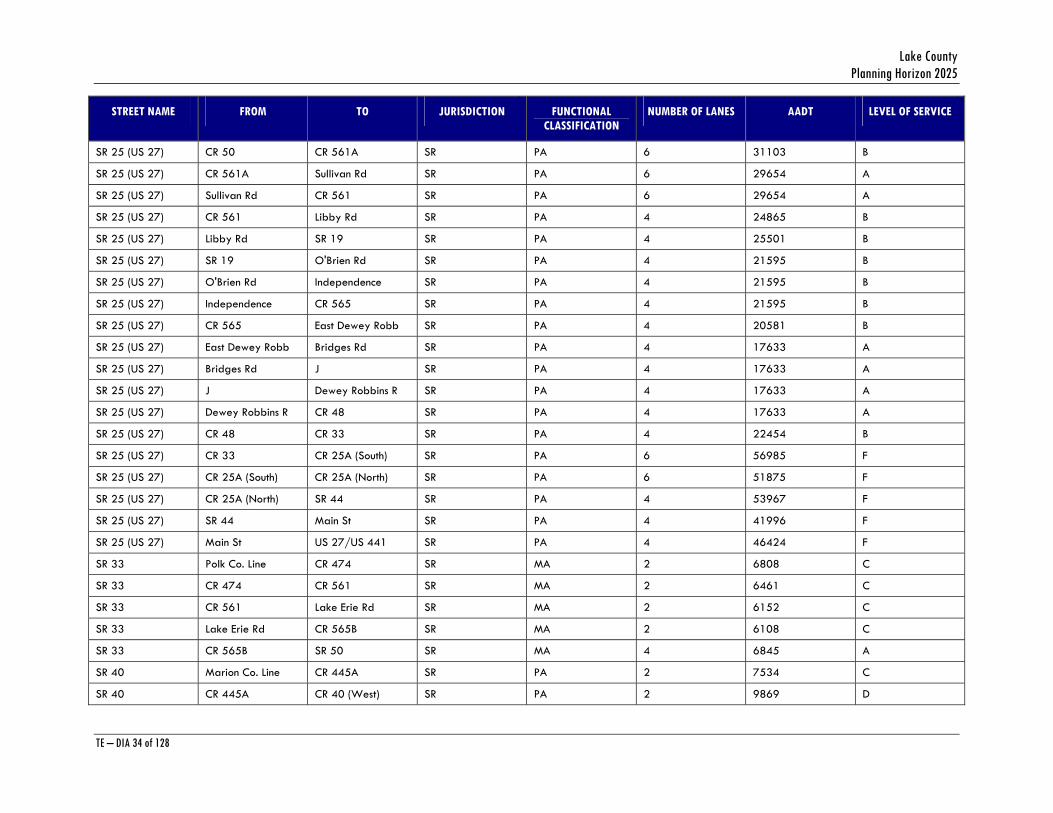
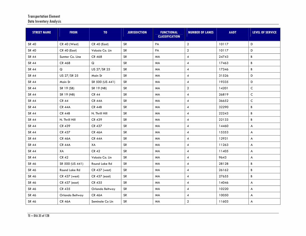
STREET NAME FROM TO JURISDICTION FUNCTIONAL CLASSIFICATION
NUMBER OF LANES AADT LEVEL OF SERVICE
SR 40 CR 40 (West) CR 40 (East) SR PA 2 10117 D
SR 40 CR 40 (East) Volusia Co. Lin SR PA 2 10117 D
SR 44 Sumter Co. Line CR 468 SR MA 4 24743 B
SR 44 CR 468 Q SR MA 4 17463 B
SR 44 Q US 27/SR 25 SR MA 4 17346 B
SR 44 US 27/SR 25 Main St SR MA 4 31526 D
SR 44 Main St SR 500 (US 441) SR MA 4 19335 D
SR 44 SR 19 (SB) SR 19 (NB) SR MA 2 14201 C
SR 44 SR 19 (NB) CR 44 SR MA 4 26819 C
SR 44 CR 44 CR 44A SR MA 4 36652 C
SR 44 CR 44A CR 44B SR MA 4 32290 B
SR 44 CR 44B N. Thrill Hill SR MA 4 22243 B
SR 44 N. Thrill Hill CR 439 SR MA 4 22133 B
SR 44 CR 439 CR 437 SR MA 4 14460 A
SR 44 CR 437 CR 46A SR MA 4 15353 A
SR 44 CR 46A CR 44A SR MA 4 12931 A
SR 44 CR 44A XA SR MA 4 11263 A
SR 44 XA CR 42 SR MA 4 11405 A
SR 44 CR 42 Volusia Co. Lin SR MA 4 9643 A
SR 46 SR 500 (US 441) Round Lake Rd SR MA 4 28128 B
SR 46 Round Lake Rd CR 437 (west) SR MA 4 26162 B
SR 46 CR 437 (west) CR 437 (east) SR MA 4 27655 B
SR 46 CR 437 (east) CR 435 SR MA 4 14046 A
SR 46 CR 435 Orlando Beltway SR MA 4 10220 A
SR 46 Orlando Beltway CR 46A SR MA 4 10050 A
SR 46 CR 46A Seminole Co Lin SR MA 2 11603 A

Lake County Planning Horizon 2025
TE – DIA 36 of 128
STREET NAME FROM TO JURISDICTION FUNCTIONAL CLASSIFICATION
NUMBER OF LANES AADT LEVEL OF SERVICE
SR 50 Sumter Co. Line Tuscanooga Rd SR PA 4 27478 B
SR 50 Tuscanooga Rd CR 565 SR PA 4 26879 B
SR 50 CR 565 Sunset Av SR PA 4 26949 B
SR 50 Sunset Av CR 33 SR PA 4 26949 B
SR 50 CR 33 CR 565 SR PA 4 34880 C
SR 50 CR 565 Ivey St SR PA 4 38024 C
SR 50 EB Ivey St SR 19 SR PA 2 22212 C
SR 50 EB SR 19 SR 33 SR PA 2 19431 B
SR 50 WB SR 33 SR 19 SR PA 2 19102 B
SR 50 WB SR 19 Ivey St SR PA 2 18448 B
SR 50 SR 33 CR 565A SR PA 4 38864 C
SR 50 CR 565A (west) CR 565A (east) SR PA 4 37980 C
SR 50 CR 565A (east) CR 561 SR PA 4 37471 C
SR 50 CR 561 SR 25 SR PA 4 54263 F
SR 50 SR 25 Grand Highway SR PA 6 59782 F
SR 50 Grand Highway Jacks Lake Rd SR PA 6 59782 F
SR 50 Jacks Lake Rd Hancock Rd SR PA 6 50467 B
SR 50 Hancock Rd CR 455 SR PA 6 60096 C
SR 50 CR 455 Orange Co. Line SR PA 6 54579 C
SR 91 Orange Co. Line Sullivan Rd SR PA 4 36993 C
SR 91 Sullivan Rd SR 19 SR PA 4 36744 C
SR 91 SR 19 CR 470 SR PA 4 29390 C
SR 91 CR 470 Sumter Co. Line SR PA 4 38005 C
US 27/US 441 SR 27/SR 25(@HI CR 466A SR PA 6 60947 F
US 27/US 441 CR 466A CR 460 SR PA 6 46988 F
US 27/US 441 CR 460 CR 25A (South) SR PA 6 43814 F

Transportation Element Data Inventory Analysis
TE – DIA 37 of 128
STREET NAME FROM TO JURISDICTION FUNCTIONAL CLASSIFICATION
NUMBER OF LANES AADT LEVEL OF SERVICE
US 27/US 441 CR 25A (South) CR 466A SR PA 6 35121 B
US 27/US 441 CR 466A CR 25A (North) SR PA 6 32407 B
US 27/US 441 CR 25A (North) Spring Lake Rd SR PA 6 37564 B
US 27/US 441 Spring Lake Rd Grays Airport R SR PA 6 39293 B
US 27/US 441 Grays Airport R Eaglesnest Rd SR PA 6 39293 B
US 27/US 441 Eaglesnest Rd Edwards Rd SR PA 6 63826 F
US 27/US 441 Edwards Rd CR 466 SR PA 6 64359 F
US 27/US 441 CR 466 CR 25 (South) SR PA 6 46512 F
US 27/US 441 CR 25 (South) CR 25 (North) SR PA 6 35613 F
US 27/US 441 CR 25 (North) Rex Rd SR PA 6 34964 B
US 27/US 441 Rex Rd Sumter Co. Line SR PA 6 35521 B
SR 500 (US 441) US 27/US 441 SR 44 SR PA 6 31470 D
SR 500 (US 441) SR 44 Main St SR PA 6 40616 C
SR 500 (US 441) Main St CR 44 SR PA 6 56009 C
SR 500 (US 441) CR 44 CR 44A (Leg) SR PA 6 35330 C
SR 500 (US 441) CR 44A (Leg) Radio Rd SR PA 6 35423 C
SR 500 (US 441) Radio Rd CR 473 SR PA 6 52524 C
SR 500 (US 441) CR 473 CR 441 (Old) SR PA 6 59149 C
SR 500 (US 441) CR 441 (Old) SR 19 SR PA 6 36499 C
SR 500 (US 441) SR 19 CR 452 SR PA 6 62724 F
SR 500 (US 441) CR 452 Lake Eustis Dr SR PA 6 68300 F
SR 500 (US 441) Lake Eustis Dr Golf Links SR PA 6 66066 F
SR 500 (US 441) Golf Links Merry Rd SR PA 6 68588 F
SR 500 (US 441) Merry Rd CR 19A SR PA 6 53350 F
SR 500 (US 441) CR 19A SR 19 SR PA 6 62817 F
SR 500 (US 441) SR 19 CR 44C SR PA 6 55706 D
Lake County Planning Horizon 2025
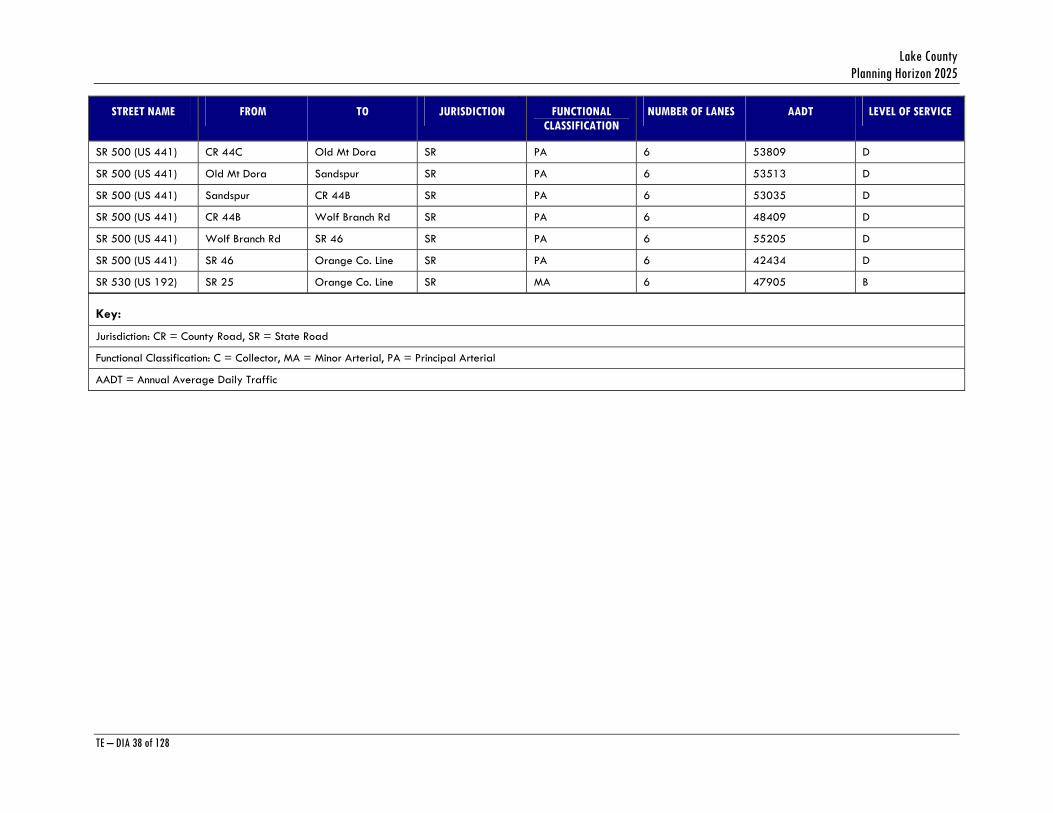
TE – DIA 38 of 128
STREET NAME FROM TO JURISDICTION FUNCTIONAL CLASSIFICATION
NUMBER OF LANES AADT LEVEL OF SERVICE
SR 500 (US 441) CR 44C Old Mt Dora SR PA 6 53809 D
SR 500 (US 441) Old Mt Dora Sandspur SR PA 6 53513 D
SR 500 (US 441) Sandspur CR 44B SR PA 6 53035 D
SR 500 (US 441) CR 44B Wolf Branch Rd SR PA 6 48409 D
SR 500 (US 441) Wolf Branch Rd SR 46 SR PA 6 55205 D
SR 500 (US 441) SR 46 Orange Co. Line SR PA 6 42434 D
SR 530 (US 192) SR 25 Orange Co. Line SR MA 6 47905 B
Key:
Jurisdiction: CR = County Road, SR = State Road
Functional Classification: C = Collector, MA = Minor Arterial, PA = Principal Arterial
AADT = Annual Average Daily Traffic
Transportation Element Data Inventory Analysis
TE – DIA 39 of 128
During the development of the 2025 Transportation Element, policies in the Comprehensive Plan regarding scenic roadways and maximum number of lanes were taken into consideration as far as recommended improvements. On other roads, improvements are scheduled to the maximum number of lanes permitted by the Comprehensive Plan, but will still experience traffic volumes that are above the roadway’s ultimate capacity. These roadways will need to be monitored to determine if and when they actually exceed adopted level of service thresholds. At that point, Lake County may have to consider designating these roadways as “constrained”. Constrained roads are those that, for physical or policy reasons, cannot be widened any further to add vehicle capacity. The State has designated US 27 in Leesburg as a constrained facility between its juncture with US 441 south to RR ROW.
While constrained roads are not candidates for future widening beyond their year 2025 lane configuration, operation of these roads can still be improved through operational improvements, such as intersection improvements, and transportation demand management strategies. Transportation demand management strategies, such as car-pooling, van-pooling, and improved transit service will be especially crucial to the future operation of US 441. While most of this roadway is programmed for expansion to six lanes in the current FDOT Work Program, future traffic volume will still be such that levels of service are projected to drop below adopted standards by the year 2025. Since widening beyond 6 lanes is neither feasible nor desirable, transportation demand management and improved transit service provide some of the few opportunities to maintain and improve capacity on this road in the years to come. The adopted Transit Development Plan and the Mass Transit Element of the Lake County Comprehensive Plan contain upgraded fixed-route transit service on the US 441 corridor. Additional measures, including the establishment of a commuter-assistance program to implement and support alternatives to single-occupant vehicle travel, such as car-pooling and van-pooling, will be a necessary adjunct to improved transit service on US 441.
Lake County supports the use of TDM and TSM (transportation system management) strategies, and will consider the following actions:
1. Development of a Transportation Systems Management Plan to outline TSM strategies. The Plan would be adopted by the Lake County Board of County Commissioners and implemented by the Public Works Department.
2. Requiring, through the Land Development Regulations, new and expanded development to provide external and internal transportation improvements made necessary by the development
3. Construction of non-motorized transportation facilities, including bike lanes, bicycle paths, and sidewalks.
In addition, Lake County also supports van-pooling, car-pooling, and other TDM measures. Future land uses may also need to be evaluated as a method of mitigating further strain on congested roadways.
Transportation needs in Lake County were assessed as part of the 2025 Transportation Plan analysis. Lake County will construct some additional roadways by the year 2025 in order to address deficiencies and enhance mobility. These improvements are listed in the adopted Cost-Feasible 2025 Long Range Transportation Plan. Further, as some additional funds become available, Lake County will evaluate additional roadway segments to further address roadway

Lake County Planning Horizon 2025
TE – DIA 40 of 128
deficiencies and mobility enhancements. These projects are listed in the Needs Plan of the 2025 Long Range Transportation Plan.
To address the impact of the traffic from major Developments of Regional Impact (DRI), Lake County will coordinate with FDOT and private developers in assessing the need for programming road improvements, and ensure the DRI developer will contribute to these improvements as required in an approved Development Order.
TRANSPORTATION CONCURRENCY
Concurrency is the concept of ensuring that required infrastructure is in place before development is functional. As in most areas of Florida, the concept of concurrency is most applicable to roadways, as that is the infrastructure most likely to be deficient. Lake County has a process in place for review of proposed development for concurrency purposes, and this process is incorporated into Lake County’s Land Development Regulations. These regulations require that necessary transportation capacity for new development to be in place or funded for construction within three years from the time development is authorized.
Lake County monitors roadway-operating conditions annually, and updates its concurrency management system to reflect any changes in roadway level of service. Annual traffic counts are posted on the Lake County website: www.lakegovernment.com
ACCESS MANAGEMENT
As part of preserving capacity along roadways, Lake County has, through Comprehensive Plan policies and its Land Development Regulations, access management requirements for new development and redevelopment along State and County roadways. For State roads, development must comply with the access management provisions of Chapters 14-96 and 14-97 of the Florida Administrative Code; and the Florida Department of Transportation’s Driveway Handbook, Median Opening and Access Management Decision Process, and the Median Handbook will be applied. For County roads, Lake County has established access management requirements outlined in the Land Development Regulations.
Particularly along congested roadways, access management is a critical component of maintaining capacity. Access management regulates such things as distances between driveways, distances between median openings, and the number of median openings, depending on the type of road. The premise behind managing access is that allowing only as many median openings and driveways as needed increases capacity by reducing vehicle “friction” on the roadway.
Transportation Element Data Inventory Analysis
TE – DIA 41 of 128
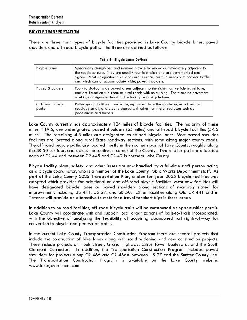
BICYCLE TRANSPORTATION
There are three main types of bicycle facilities provided in Lake County: bicycle lanes, paved shoulders and off-road bicycle paths. The three are defined as follows:
Table 6 - Bicycle Lanes Defined
Bicycle Lanes Specifically designated and marked bicycle travel-ways immediately adjacent to the roadway curb. They are usually four feet wide and are both marked and signed. Most designated bike lanes are in urban, built up areas with heavier traffic and which cannot accommodate wide, paved shoulders.
Paved Shoulders Four- to six-foot wide paved areas adjacent to the right-most vehicle travel lane, and are found on suburban or rural roads with no curbing. There are no pavement markings or signage denoting the facility as a bicycle lane.
Off-road bicycle paths
Pathways up to fifteen feet wide, separated from the roadway, or not near a roadway at all, and usually shared with other non-motorized users such as pedestrians and skaters.
Lake County currently has approximately 124 miles of bicycle facilities. The majority of these miles, 119.5, are undesignated paved shoulders (65 miles) and off-road bicycle facilities (54.5 miles). The remaining 4.5 miles are designated as striped bicycle lanes. Most paved shoulder facilities are located along rural State roadway sections, with some along major county roads. The off-road bicycle paths are located mostly in the southern part of Lake County, roughly along the SR 50 corridor, and across the southwest corner of the County. Two smaller paths are located north of CR 44 and between CR 445 and CR 42 in northern Lake County.
Bicycle facility plans, safety, and other issues are now handled by a full-time staff person acting as a bicycle coordinator, who is a member of the Lake County Public Works Department staff. As part of the Lake County 2025 Transportation Plan, a plan for year 2025 bicycle facilities was adopted which provides for additional on and off-road bicycle facilities. Most new facilities will have designated bicycle lanes or paved shoulders along sections of roadway slated for improvement, including US 441, US 27, and SR 50. Other facilities along Old CR 441 and in Tavares will provide an alternative to motorized travel for short trips in those areas.
In addition to on-road facilities, off-road bicycle trails will be constructed as opportunities permit. Lake County will coordinate with and support local organizations of Rails-to-Trails Incorporated, with the objective of analyzing the feasibility of acquiring abandoned rail rights-of-way for conversion to bicycle and pedestrian paths.
In the current Lake County Transportation Construction Program there are several projects that include the construction of bike lanes along with road widening and new construction projects. These include projects on Hook Street, Grand Highway, Citrus Tower Boulevard, and the South Clermont Connector. In addition, the Transportation Construction Program includes paved shoulders for projects along CR 466 and CR 466A between US 27 and the Sumter County line. The Transportation Construction Program is available on the Lake County website: www.lakegovernment.com

Lake County Planning Horizon 2025
TE – DIA 42 of 128
PEDESTRIAN CIRCULATION
As of 1997, there were sidewalks on approximately 21 percent of the urban road network in Lake County, concentrated in the Leesburg, Tavares, Mount Dora and Eustis urbanized areas. Additional sidewalk was along sections of SR 50 in the cities of Clermont, Mascotte, and Groveland in southern Lake County.
Planning for pedestrian facilities is done through the Lake County Public Works Department. The 2006-2010 Transportation Construction Program, found in Appendix A of this document, includes several programmed projects that include sidewalk construction.
Pedestrian access to schools, shopping centers, and neighborhoods also need to be addressed. These needs can partially be met through provisions in the Lake County Land Development Regulations. However, an inventory of existing local sidewalk connectivity and needs should be completed in order to prioritize the construction of sidewalks in these areas.
Mass Transit
Major transportation routes within the Lake County area include U.S. Highways 27 and 441 and State Roads 44, 19, and 50. Both U.S. Highways 27 and 441 are pre-interstate, major north-south thoroughfares, which traverse the interior of Florida from the Georgia state line. U.S. 27 borders Leesburg. U.S. 441 borders the Leesburg airport on the north. State Road 44 traverses Lake County from east to west. This road goes across the state from New Smyrna Beach on the Atlantic Coast, to the town of Homosassa Springs, near the Gulf of Mexico. State Road 44 is located north of 441 and runs from east to west. SR 50 runs east to west from the Orange County line across Lake County to the Sumter County line. SR 19 runs north-south from the Ocala National Forest to Groveland.
The year 2000 census population was 210,528 individuals and ranked 168th among the nation's counties. It is seen that the population density is lower than the state average (221 vs. 296 persons per square mile). Lake County has a higher percentage of retirees (65+) than the state average (26.4 percent vs. 17.6 percent). The percentage of residents who were below the poverty level is under the state average (12.8 percent vs. 14.4 percent).
Because the population density is very low, there are distinct challenges to the design and operation of transportation services to the residents of neighborhoods and communities. The challenge is to provide timely service to the passengers who live and work at such distances from each other that they must be served virtually one at a time. Any grouping of trips becomes progressively more difficult as the density declines. The cost per trip increases drastically with the decline in the number of passengers riding together. Demand response transit is usually the most successful mode along the corridors where the dwelling unit density is below 6 DU/Acre. Fixed route transit becomes viable once the density increases to above 6 DU/Acre. As the population density increases in Lake County, fixed route transit has a potential to play a major role in meeting mobility needs.

Transportation Element Data Inventory Analysis
TE – DIA 43 of 128
MAJOR TRIP GENERATORS AND ATTRACTORS
Congested corridors are also a consideration as opportunities for transit service are considered. Transit provides an alternative to single-occupant vehicle travel on congested roadways, and can serve to increase mobility along corridors which are constrained from further single-vehicle capacity improvements because of either physical or policy constraints.
Major activity centers in Lake County were identified in the Lake County 2025 Transportation Plan adopted in 2005. These trip generators and attractors include hospitals, medical centers/clinics, post secondary schools, and shopping centers. Activity center locations are a major consideration as future transit service alternatives are evaluated.
EXISTING PUBLIC TRANSPORTATION FACILITIES/SERVICES
The Board of County Commissioners currently serves as the Community Transportation Coordinator for the Lake County service area. The Community Transportation Coordinator is responsible for the arrangement of the delivery of transportation services to the transportation disadvantaged population and general public.
The CTC operates as a full brokerage entity and contracts the transportation services to MV Transportation which does business as Lake County Connection. Currently the CTC only offers paratransit service and subscription service. A service route with deviation was previously operated; however, that service was discontinued during the 2003 fiscal year. All services currently provided is door to door service. Plans are underway for fixed route transportation services to be implemented in 2006 after the completion of the Transit Operation Plan is completed.
In FY 2004, there were a total of 67 vehicles in the coordinated system. Fifty of the vehicles are owned by the Board of County Commissioners. Sixty -eight (68%) of the vehicles are wheelchair accessible.
Marketing Techniques And Program
Table 7 of the TDP provides a summary of transit marketing techniques, along with recommendations regarding the applicability of the marketing techniques for use in Lake County. This table, which was originally presented in the previous Lake County TDP, was reviewed and modified for this TDP update.
The marketing techniques are organized into four major categories, including pricing, promotional, media advertising, and market research. The extent of use, evidence of success, and perceived success is provided for each technique based on observations of marketing activities of transit systems throughout the United States. The applicability of the techniques is also indicated in the table. This column also indicates a check mark for marketing activities recommended for inclusion in the Lake County Transit marketing program. Primary and secondary marketing activities recommended for the marketing program include the following:
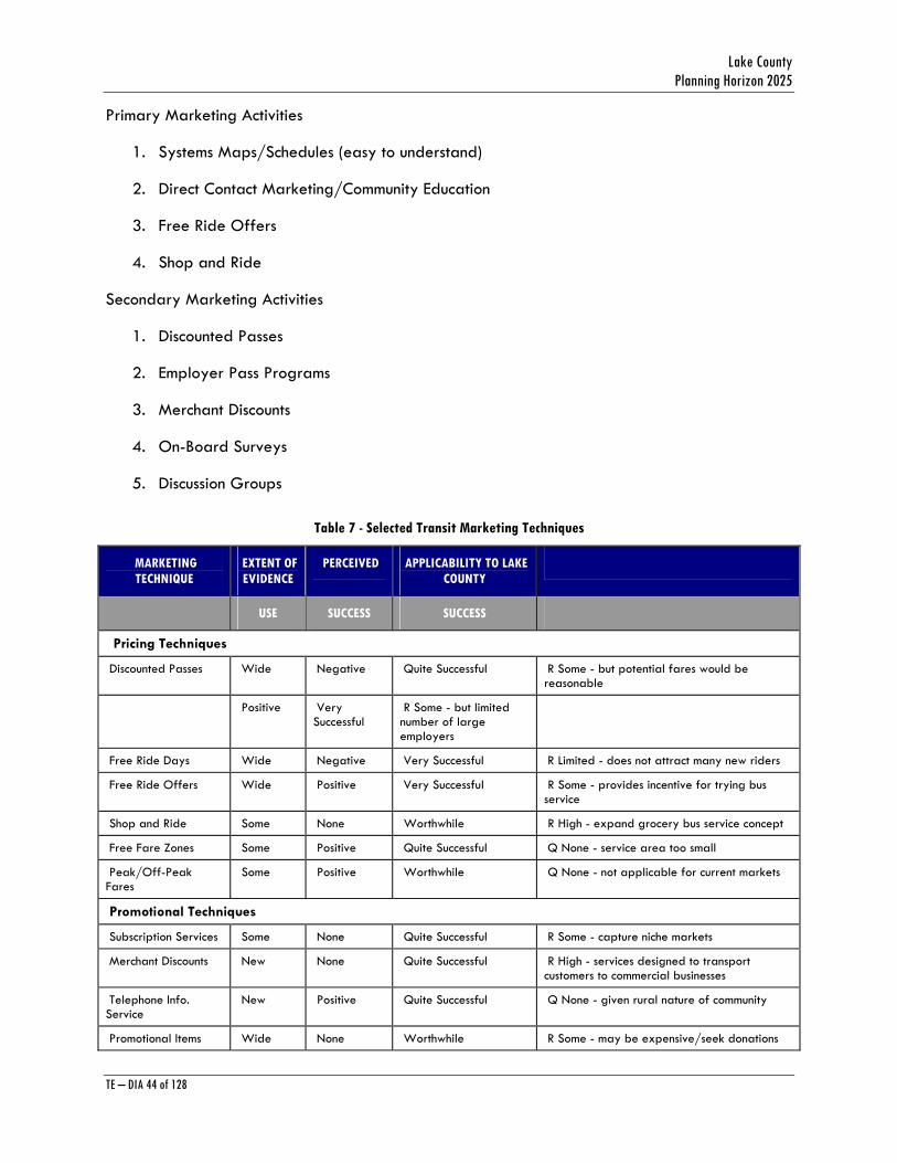
Lake County Planning Horizon 2025
TE – DIA 44 of 128
Primary Marketing Activities
1. Systems Maps/Schedules (easy to understand)
2. Direct Contact Marketing/Community Education
3. Free Ride Offers
4. Shop and Ride
Secondary Marketing Activities
1. Discounted Passes
2. Employer Pass Programs
3. Merchant Discounts
4. On-Board Surveys
5. Discussion Groups
Table 7 - Selected Transit Marketing Techniques
MARKETING TECHNIQUE
EXTENT OF EVIDENCE
PERCEIVED APPLICABILITY TO LAKE COUNTY
USE SUCCESS SUCCESS
Pricing Techniques
Discounted Passes Wide Negative Quite Successful R Some - but potential fares would be reasonable
Positive Very Successful
R Some - but limited number of large employers
Free Ride Days Wide Negative Very Successful R Limited - does not attract many new riders
Free Ride Offers Wide Positive Very Successful R Some - provides incentive for trying bus service
Shop and Ride Some None Worthwhile R High - expand grocery bus service concept
Free Fare Zones Some Positive Quite Successful Q None - service area too small
Peak/Off-Peak Fares
Some Positive Worthwhile Q None - not applicable for current markets
Promotional Techniques
Subscription Services Some None Quite Successful R Some - capture niche markets
Merchant Discounts New None Quite Successful R High - services designed to transport customers to commercial businesses
Telephone Info. Service
New Positive Quite Successful Q None - given rural nature of community
Promotional Items Wide None Worthwhile R Some - may be expensive/seek donations

Transportation Element Data Inventory Analysis
TE – DIA 45 of 128
MARKETING TECHNIQUE
EXTENT OF EVIDENCE
PERCEIVED APPLICABILITY TO LAKE COUNTY
USE SUCCESS SUCCESS
from community
Anniversary Promotions Wide
None Quite Successful
R Some - may be expensive/seek donations from community
Direct Contact Marketing New
Positive Quite Successful
R High - presentations to community groups/information
booths/transit fairs
Media Advertising
Newspaper Wide Positive Quite Successful R Limited - cost may be too high
Radio Wide Positive Quite Successful R Limited - cost may be too high
Outdoor Some None Worthwhile R Limited - cost may be too high
Television Some Positive Quite Successful R Limited - cost may be too high
Cable Television New New New R Limited - cost may be too high
Community Education Wide None Quite Successful R High - inexpensive/use with direct marketing
System Maps Wide Conflicting Very Successful R High - understanding of routes and schedules
Newsletters Some None Worthwhile R Some - requires labor commitment but can be inexpensive
Internet New None Worthwhile R High - inexpensive if County has web site
On-Board Surveys Wide Positive Worthwhile R Some - inexpensive with driver cooperation
General Public Surveys
Some None Worthwhile R Limited - community perception of transit
Discussion Groups Some Positive Quite Successful R High - special form of direct contact marketing
Source: Lake County 1999-2003 TDP
PUBLIC TRANSPORTATION NEEDS AND POTENTIAL MARKETS
Determinations of needed transit improvements have been developed through the Transit Development Plan (TDP) and Transportation Disadvantaged Service Plan (TDSP) processes. These needs include the necessity for providing additional service to the general public to major trip generators and attractors and along congested roadways, as well as enhancing service provided to the transportation disadvantaged. The TDSP and TDP adopted in 2005 recommended that the CTC implement a fixed route transportation system.
Based on the existing and forecast demand, the following general needs were identified:
1. An increase in hours and days of service.
2. More frequent service
Lake County Planning Horizon 2025
TE – DIA 46 of 128
3. Better marketing of public transportation services, and educating existing and potential transit customers on using the transit system.
4. Expanded geographic coverage of service routes to provide greater linkage between cities and activity centers.
Public hearings were held in May 2004 and September 2004 to obtain citizens input on transit needs in the county.
According to the participants, people living in the more rural areas of the county need to be connected to the more urbanized areas, such as connecting individuals living on CR-42 to the commercial districts along US-441. Other suggestions included:
1. Connectivity - Residents would like to see the system connect with LYNX, either in Tangerine, Zellwood, or Mt. Dora.
2. Efficient and reliable service should be provided to all adult communities.
3. Individuals would use public transit more often if it were available.
4. Need more frequent service than that planned (i.e., about once every 3.5 hours) if service is expected to meet mobility needs and be successful.
5. Door-to-Door Service is necessary for elderly persons who cannot wait at a bus shelter for an extended period of time.
6. Marketing - Better public education is needed.
7. Door-to-Door Service - Should be maintained in conjunction with public transit.
8. Reliable routes and times are needed.
9. Connectivity - Service connecting Clermont and Orlando is needed.
10. Connectivity - Service connecting Clermont to local hospitals is needed.
11. Connectivity - Service connecting Clermont to West Oaks Mall is needed.
12. Connectivity - Ability to transfer to other bus routes to go to Clermont and Orlando is needed.
13. Service - There is a need for public transit on CR 42; also consider service on CR 40 and CR 44.
14. Service - Should be provided to Lake-Sumter Community College and the YMCA.
15. Service - Reliable service should be provided for elderly persons who cannot drive.
16. Drivers - Ensure that drivers are content with jobs and that drivers are pleasant towards riders.

Transportation Element Data Inventory Analysis
TE – DIA 47 of 128
17. Service - Need to provide transportation services for after-school mentoring programs for at-risk kids (Umatilla and Paisley).
18. Signage - Make sure stops are well marked.
19. Bus Stops - Ensure that there is appropriate support infrastructure, like shelters and benches, at major stops since many elderly patrons will not be able to stand or remain in the heat/sun for extended periods.
20. Need to address protocol for sight-impaired patrons flagging down a bus since they will not be able to see an approaching vehicle.
Significant public transit corridors have been divided into two (2) groups—primary and secondary—as identified below:
Table 8 - Primary Corridors
PRIMARY CORRIDORS
Corridor 2 U.S. 441 from U.S. 27 (Lady Lake) to C.R. 44 (Leesburg)
Corridor 3 U.S. 441 from Main Street (Leesburg) to C.R. 44 (Mount Dora)
Corridor 4 S.R. 19 from U.S. 441 (Mount Dora) to C.R. 450 (Umatilla)
Corridor 6: U.S. 27 from S.R. 50 (Clermont) to Main St. (Leesburg)
Table 9 - Secondary Corridors
SECONDARY CORRIDORS
Corridor 1: C.R. 44 from C.R. 468 (Leesburg) to S.R. 19 (Eustis)
Corridor 5: S.R. 50 from C.R. 565 (Mascotte) to C.R. 455 (Clermont)
The Americans with Disabilities Act (ADA) of 1990 requires that complimentary paratransit services be provided by agencies that operate fixed-route bus service. The paratransit service must “shadow” the fixed-route service area and a comparable level of service must be provided for persons who cannot use the fixed-route service.
Several broad strategies have been developed through the TDP and TDSP process to meet needs identified in those documents. These strategies form a framework for specific actions, and include:
1. Transitioning services from door to door to a fixed route system. Fixed-route bus service should be provided on a repetitive, fixed-schedule basis along specific routes, with vehicles stopping to pick up and deliver passengers to specific locations. Each fixed route would serve the same origins and destinations, unlike demand response and taxicab service.
2. Implementing additional fixed-route or service deviation routes along the corridors identified as being underserved by the current door-to-door service. Likewise, the existing demand response service should be enhanced to improve the effectiveness and efficiency of that service.

Lake County Planning Horizon 2025
TE – DIA 48 of 128
3. Implement plans to ensure that all persons who currently use door to door service are able to utilize the fixed-route service.
4. Develop a marketing plan to strengthen ridership, particularly for off-peak hours and days. Also, an educational outreach program should be initiated to educate existing and potential riders on using the transit system.
5. Development of monitoring procedures to ensure that plans are implemented, and specified performance standards are met. The monitoring program should include two major elements: performance measures, and an annual quality of service survey. Performance measures such as transit ridership, operating expense per vehicle mile, operating expense per passenger trip, and passenger trips per vehicle mile should be monitored. Annual quality of service surveys, to provide a perspective from the system user and also compare of the quality of service over time, should be conducted. Surveys should seek customer satisfaction regarding, at a minimum, days and hours of service, frequency of service, convenience of routes, bus fares, and availability and clarity of bus route information.
6. As an adjunct to transit service, transportation demand management programs, such as car-pooling and van-pooling, can further enhance mobility along congested corridors and areas not served by fixed-route. Additionally, these programs encourage alternatives to single-occupant vehicle travel, and reduce dependence on automobiles for mobility. Policies and regulations providing preferential parking privileges to vanpools and carpools should be implemented to encourage use of these programs. Also, a re-examination of regulations prescribing minimum numbers of parking spaces may present opportunities to reduce parking and increase transit and TDM use.
Public Transportation Strategies to Meet Identified Needs
The purpose is to provide a safe, economically efficient, and accessible public transportation system that will meet the mobility and accessibility needs of all residents and visitors traveling in Lake County, and to examine the feasibility of establishing alternative public transportation services to meet the transportation needs of the general public by implementing the most cost effective public transportation services possible.
For all public transportation services that are provided, Lake County will ensure that a high level of service quality is provided, maintained, and improved as necessary, and that there will be increased visibility and utilization of public transportation services through marketing, education, improvement of existing services, and the development of new services.
Lake County will also pursue coordination activities with other jurisdictions and transportation providers; maximize the use of all funding sources and services, public and private, in meeting the need for general public transit services; ensure that the mobility needs of the transportation disadvantaged population in Lake County are identified and met; and encourage land use patterns that support and promote transit patronage through the clustering of mixed uses and other transit-oriented designs in medium and large scale planned developments.
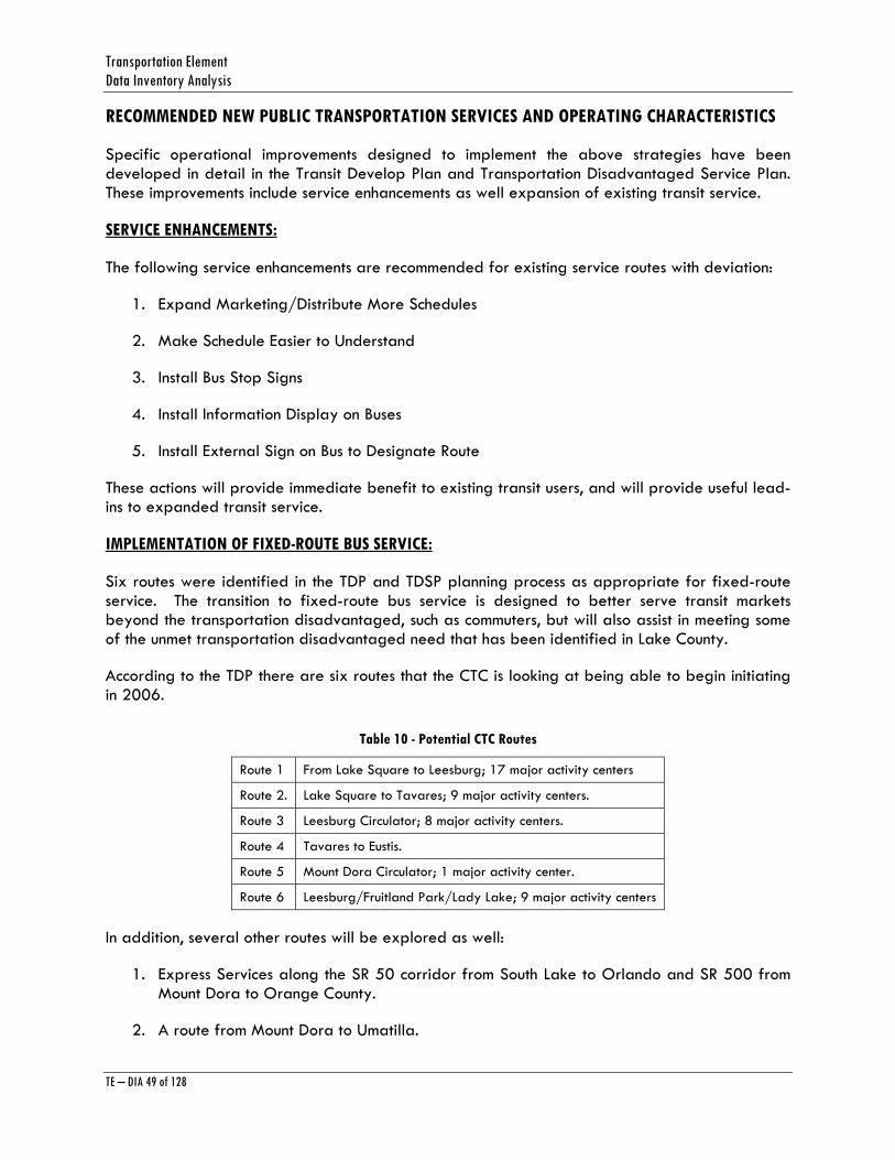
Transportation Element Data Inventory Analysis
TE – DIA 49 of 128
RECOMMENDED NEW PUBLIC TRANSPORTATION SERVICES AND OPERATING CHARACTERISTICS
Specific operational improvements designed to implement the above strategies have been developed in detail in the Transit Develop Plan and Transportation Disadvantaged Service Plan. These improvements include service enhancements as well expansion of existing transit service.
SERVICE ENHANCEMENTS:
The following service enhancements are recommended for existing service routes with deviation:
1. Expand Marketing/Distribute More Schedules
2. Make Schedule Easier to Understand
3. Install Bus Stop Signs
4. Install Information Display on Buses
5. Install External Sign on Bus to Designate Route
These actions will provide immediate benefit to existing transit users, and will provide useful lead-ins to expanded transit service.
IMPLEMENTATION OF FIXED-ROUTE BUS SERVICE:
Six routes were identified in the TDP and TDSP planning process as appropriate for fixed-route service. The transition to fixed-route bus service is designed to better serve transit markets beyond the transportation disadvantaged, such as commuters, but will also assist in meeting some of the unmet transportation disadvantaged need that has been identified in Lake County.
According to the TDP there are six routes that the CTC is looking at being able to begin initiating in 2006.
Table 10 - Potential CTC Routes
Route 1 From Lake Square to Leesburg; 17 major activity centers
Route 2. Lake Square to Tavares; 9 major activity centers.
Route 3 Leesburg Circulator; 8 major activity centers.
Route 4 Tavares to Eustis.
Route 5 Mount Dora Circulator; 1 major activity center.
Route 6 Leesburg/Fruitland Park/Lady Lake; 9 major activity centers
In addition, several other routes will be explored as well:
1. Express Services along the SR 50 corridor from South Lake to Orlando and SR 500 from Mount Dora to Orange County.
2. A route from Mount Dora to Umatilla.
Lake County Planning Horizon 2025
TE – DIA 50 of 128
3. A route from Leesburg to Clermont.
Coordination with other Fixed-Route Services:
Opportunities exist to coordinate with other transportation services in the region, and provide additional mobility choices to those regularly traveling to and from Lake County.
1. Lynx Services: Lake County borders Orange County, which is served by the Lynx transit service. Lynx has added an express service from the West Oaks Mall to Downtown Orlando and the University of Central Florida, via the East West Expressway. Other opportunities to coordinate with and connect to the Lynx system include connecting to U.S. 192 Corridor Service, and developing a joint Commuter Services via the Lynx Van Plan or another jointly developed service. Van Plan is a program that provides a van and maintenance to a group that provides a driver and fuel, for commuting in Orange County.
Lynx is currently providing services in the Four Corners area of the County. Other opportunities will be explored for joint commuter services with Lynx, as well as Sumter County, Marion County, and VOTRAN.
2. Commuter Rail (along Northwest Corridor): Lake County should coordinate with the Central Florida Regional Transportation Authority and FDOT District 5 with respect to the consideration of commuter rail in Central Florida. This is particularly true as it relates to the Northwest Corridor that includes Lake County. The northern limit of the corridor is the City of Eustis, while the southern limit is Downtown Orlando. The length of the corridor is approximately 33 miles. The 1994 “Corridor Designation Report” indicates that existing Florida Central Railroad right-of-way would be used for service in this corridor but new track would be required to meet specifications for commuter rail operations.
3. Tri-county Transportation Initiative: The intent is to expand transit services to the rapidly growing Lady Lake-Villages urbanized area. The Transportation Initiative is the first step in allowing Sumter County Transit the ability to serve residents in the entire Lady Lake-Villages area. Sumter County Transit currently provides bus service to a portion of the Villages.
The increased bus service in the Lady Lake-Villages urbanized area is expected to come to fruition in about a year as the Lake-Sumter MPO and the Ocala/Marion County Transportation Planning Organization will begin working on funding details and proposed routes for the planned service.
AVIATION/ RAIL
Within Lake County, there are 21 FAA landing facilities, located at three public airports, ten private airports, and two heliports (one each at Leesburg Regional Medical Center and Florida Hospital/Waterman in Tavares). At the present time, there is no commercial air carrier service in Lake County. Commercial air carrier service is available at the Orlando International Airport in Orange County, and the Orlando Sanford Airport in Seminole County (charter service).
Airport facilities that are improved, maintained, or operated by a governmental agency, or privately-owned airports with paved runways of at least 4,000 feet, must be included in the
Transportation Element Data Inventory Analysis
TE – DIA 51 of 128
Aviation/Rail Element. As of this time, only two airports in Lake County meet those requirements: Leesburg Regional Airport, located in Leesburg, and Umatilla Municipal Airport in Umatilla. Mid-Florida Airport, which is a private facility located in Eustis and has a grass landing strip, is included because it is designated as a general aviation facility in the East Central Florida Metropolitan Aviation System Plan. These airports are shown in Map IV-1.
Lake County does not own, control, or operate any of the air facilities located in Lake County. Therefore, its role is one of controlling land use adjacent to airports and coordination of the airports with other modes of transportation. This coordination role is reflected in the Goals, Objectives, and Policies of the Aviation/Rail Element.
Information on the existing conditions, existing and future operations, and planned improvements for Leesburg Regional, Umatilla Municipal, and Mid-Florida airports is provided below.
Leesburg Regional Airport
Leesburg Regional Airport is located within the municipal limits of the City of Leesburg approximately four miles east of downtown Leesburg on U.S. 441. The City of Leesburg is located in Central Florida’s Lake County, about 40 miles northwest of Orlando. Lake County is bordered to the north by Marion County, to the west by Sumter County, to the south by Orange County, and to the east by Seminole County. Leesburg can be characterized as a moderately growing community of approximately 15,600 permanent residents, and approximately 4,200 seasonal residents. Three major natural features have strongly shaped local development of the community, including Lake Harris, Lake Griffin, and Okahumpka Swamp. Lake Harris borders the Airport to the south.
The Leesburg Regional Airport is a public use, general aviation airport owned, operated, and maintained by the City of Leesburg. The Airport Master Plan was last updated in June 1998. The base year for the previous master plan was 1992. Since that time, the City of Leesburg and the surrounding areas have experienced significant growth. Since 1990, the City of Leesburg population increased from 14,783 to nearly 15,500. Lake County grew by 38.4 percent from 1990 to 2000, from 152,104 in 1990 to 210,528 in 2000, an increase of 58,424 persons.
The Leesburg Regional Airport has also experienced steady growth which coincides with growth in the City and County. Total aircraft operations increased from 90,600 in 1990 to more than 103,462 in 1998, a net change of 14 percent. Based aircraft increased from 152 to 165 in the same period. Operational activity has surpassed the forecasts prepared in the previous Airport Master Plan. Those projections, prepared in 1987, indicated that by 2007, annual operations were projected to reach 82,800.
There are seven public use airports within an approximately 30 nautical mile radius of the Airport. All of these airports serve the needs of general aviation users, yet they vary greatly in the facilities available and in services provided. For example, Orlando-Sanford accommodates numerous daily international charter flights. Two additionally privately owned airports, Bob White Field and Orlando County, are also located within 30 nautical miles of Leesburg Regional Airport.
Leesburg Regional Airport recently established a U.S. Customs and Border Protection inspection program. This service is available because the City of Ocala and the City of Leesburg entered into an Interlocal Agreement to share a U.S. Customs & Border Protection Officer. The advantage
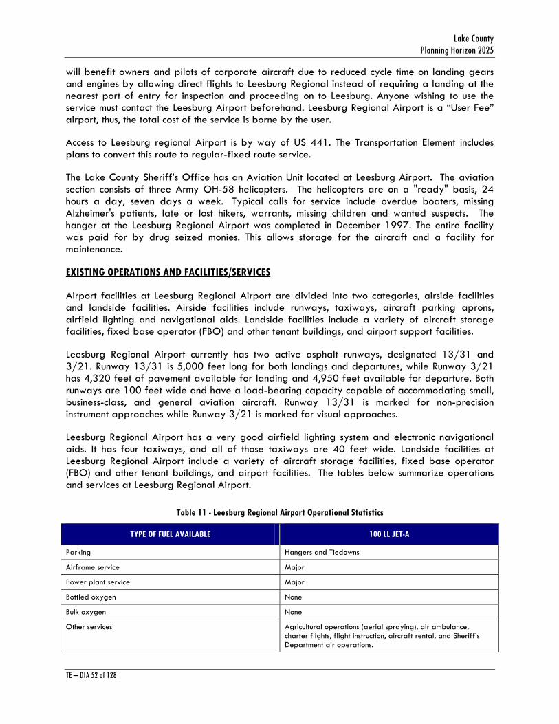
Lake County Planning Horizon 2025
TE – DIA 52 of 128
will benefit owners and pilots of corporate aircraft due to reduced cycle time on landing gears and engines by allowing direct flights to Leesburg Regional instead of requiring a landing at the nearest port of entry for inspection and proceeding on to Leesburg. Anyone wishing to use the service must contact the Leesburg Airport beforehand. Leesburg Regional Airport is a “User Fee” airport, thus, the total cost of the service is borne by the user.
Access to Leesburg regional Airport is by way of US 441. The Transportation Element includes plans to convert this route to regular-fixed route service.
The Lake County Sheriff’s Office has an Aviation Unit located at Leesburg Airport. The aviation section consists of three Army OH-58 helicopters. The helicopters are on a "ready" basis, 24 hours a day, seven days a week. Typical calls for service include overdue boaters, missing Alzheimer's patients, late or lost hikers, warrants, missing children and wanted suspects. The hanger at the Leesburg Regional Airport was completed in December 1997. The entire facility was paid for by drug seized monies. This allows storage for the aircraft and a facility for maintenance.
EXISTING OPERATIONS AND FACILITIES/SERVICES
Airport facilities at Leesburg Regional Airport are divided into two categories, airside facilities and landside facilities. Airside facilities include runways, taxiways, aircraft parking aprons, airfield lighting and navigational aids. Landside facilities include a variety of aircraft storage facilities, fixed base operator (FBO) and other tenant buildings, and airport support facilities.
Leesburg Regional Airport currently has two active asphalt runways, designated 13/31 and 3/21. Runway 13/31 is 5,000 feet long for both landings and departures, while Runway 3/21 has 4,320 feet of pavement available for landing and 4,950 feet available for departure. Both runways are 100 feet wide and have a load-bearing capacity capable of accommodating small, business-class, and general aviation aircraft. Runway 13/31 is marked for non-precision instrument approaches while Runway 3/21 is marked for visual approaches.
Leesburg Regional Airport has a very good airfield lighting system and electronic navigational aids. It has four taxiways, and all of those taxiways are 40 feet wide. Landside facilities at Leesburg Regional Airport include a variety of aircraft storage facilities, fixed base operator (FBO) and other tenant buildings, and airport facilities. The tables below summarize operations and services at Leesburg Regional Airport.
Table 11 - Leesburg Regional Airport Operational Statistics
TYPE OF FUEL AVAILABLE 100 LL JET-A
Parking Hangers and Tiedowns
Airframe service Major
Power plant service Major
Bottled oxygen None
Bulk oxygen None
Other services Agricultural operations (aerial spraying), air ambulance, charter flights, flight instruction, aircraft rental, and Sheriff’s Department air operations.
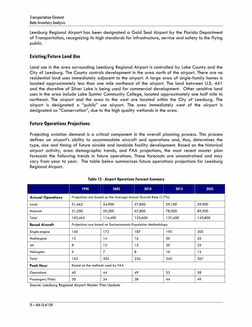
Transportation Element Data Inventory Analysis
TE – DIA 53 of 128
Leesburg Regional Airport has been designated a Gold Seal Airport by the Florida Department of Transportation, recognizing its high standards for infrastructure, service and safety to the flying public.
Existing/Future Land Use
Land use in the area surrounding Leesburg Regional Airport is controlled by Lake County and the City of Leesburg. The County controls development in the area north of the airport. There are no residential land uses immediately adjacent to the airport. A large area of single-family homes is located approximately less than one mile northeast of the airport. The land between U.S. 441 and the shoreline of Silver Lake is being used for commercial development. Other sensitive land uses in the area include Lake Sumter Community College, located approximately one half mile to northeast. The airport and the area to the west are located within the City of Leesburg. The airport is designated a “public” use airport. The area immediately west of the airport is designated as “Conservation”, due to the high quality wetlands in the area.
Future Operations Projections
Projecting aviation demand is a critical component in the overall planning process. This process defines an airport’s ability to accommodate aircraft and operations and, thus, determines the type, size and timing of future airside and landside facility development. Based on the historical airport activity, area demographic trends, and FAA projections, the most recent master plan forecasts the following trends in future operations. These forecasts are unconstrained and may vary from year to year. The table below summarizes future operations projections for Leesburg Regional Airport.
Table 12 - Airport Operations Forecast Summary
1998 2005 2010 2015 2025
Annual Operations Projections are based on the Average Annual Growth Rate (1.7%)
Local 51,462 54,900 57,800 59,100 59,900
Itinerant 51,200 59,500 67,800 78,300 89,900
Total 103,462 114,400 125,600 137,400 149,800
Based Aircraft Projections are based on Socioeconomic-Population Methodology
Single-engine 140 172 187 195 205
Multiengine 12 14 16 20 25
Jet 8 12 15 20 25
Helicopter 5 7 8 10 12
Total 165 204 224 245 267
Peak Hour Based on the methods used by FAA
Operations 40 44 49 53 58
Passengers/Pilots 30 34 38 44 49
Source: Leesburg Regional Airport Master Plan Update
Lake County Planning Horizon 2025
TE – DIA 54 of 128
PLANNED IMPROVEMENTS
In order for Leesburg Regional Airport to meet the projected demand, it will require significant landside and airside improvements. The following summarizes the identified facility requirements contained in the Leesburg Regional Airport Master Plan:
1. The Airport capacity is adequate to accommodate the projected number of operations. But, the airport’s primary runway should be designed to accommodate demanding business jets as well as possible charter aircraft.
2. In order to accommodate the above-mentioned traffic activity, Runway 13/31 should be extended to 6,300 feet, while Runway 3/21 should be extended to 5,500 feet. Work has commenced to extend Runway 13/31 and should be complete by 2007.
3. Additional T-Hangar units and conventional hangar space are needed to accommodate future demand.
4. An air traffic control tower is recommended, apart from the additional apron to accommodate itinerant aircraft needs, and tie-down spaces to accommodate for the increase in based aircraft.
ENVIRONMENTAL IMPACT SUMMARY
Based on the preliminary analysis of Leesburg Regional Airport Master Plan, detailed investigations will be required to address noise, wetlands, floodplains, biotic communities, endangered species and water quality impacts of planned improvements. Coordination with various federal, state and local reviewing agencies will be required to determine the extent of these impacts. For impacts that exceed state and federal limits, approved mitigation strategies/plans will be required.
FUNDING SOURCES FOR LEESBURG REGIONAL AIRPORT
Funding for planned improvements may come from several sources. These sources include:
1. Most public use airports improvements are eligible for 90% federal funding and 80% State funding. General aviation terminal buildings, T-hangars, and corporate hangars and other private use facilities are not eligible for federal funding. Revenue producing items such as automobile parking lots are not eligible for federal funding.
2. The Department of Aviation (FDOT) administers state funding for airport improvements. Similar to the Federal Trust Fund, funding from the state is derived from user fees (i.e. aircraft fuel taxes and the state sales tax on aircraft). A significant percentage of gasoline taxes are assigned for aviation infrastructure development.
3. Local funding is currently provided by the City of Leesburg and Lake County. Leesburg Airport receives operating income from tenant lease fees and local subsidies.
Another potential source for airport improvements is private investors. Private investors may construct needed facilities as part of a lease agreement with the Airport Board that will allow time to amortize their investments. This type of funding is particularly suitable for corporate
Transportation Element Data Inventory Analysis
TE – DIA 55 of 128
hangar development since they are not eligible for FAA funding but are eligible for State funding at a 50% level.
Phasing for planned improvements is summarized in the table below
:

Lake County Planning Horizon 2025
TE – DIA 56 of 128
Table 13 - Leesburg Regional Airport Capital Improvement Plan Fiscal years 2005-2015
PROJECT DESCRIPTION
FISCAL YEAR
2004-05
FISCAL YEAR
2005-06
FISCAL YEAR
2006-07
FISCAL YEAR
2007-08
FISCAL YEAR
2008-09
FISCAL YEAR
2009-10
FISCAL YEAR
2010-11
FISCAL YEAR
2011-12
FISCAL YEAR
2012-13
FISCAL YEAR
2013-14
FISCAL YEAR
2014-15
TOTAL
Apron east of Taxiway B
350,000 350,000
Extend Runway 13/31
200,000 4,000,000 4,200,000
Instrument Landing System Equipment
350,000 350,000
Overcoat GA Ramp Area
150,000 150,000
FBO Ramp Space Phase II
360,000 360,000
Permit/Mitigate RW 13/31 Extension
150,000 150,000
Small Corporate Hangars
650,000 650,000
Taxilane to Cracker Barrel
600,000 600,000
T-hangars 350,000 350,000
Drainage Improvements—Phillips Hangar
60,000 60,000
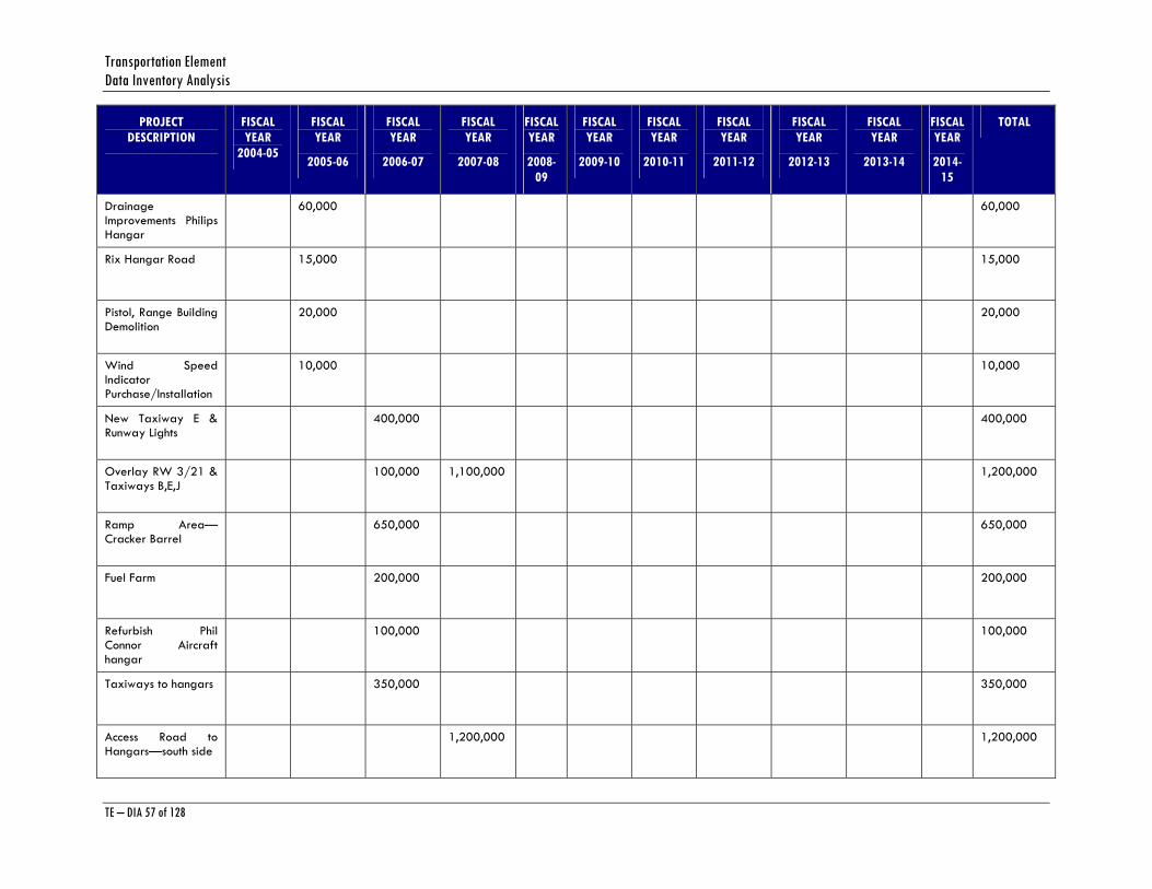
Transportation Element Data Inventory Analysis
TE – DIA 57 of 128
PROJECT DESCRIPTION
FISCAL YEAR
2004-05
FISCAL YEAR
2005-06
FISCAL YEAR
2006-07
FISCAL YEAR
2007-08
FISCAL YEAR
2008-09
FISCAL YEAR
2009-10
FISCAL YEAR
2010-11
FISCAL YEAR
2011-12
FISCAL YEAR
2012-13
FISCAL YEAR
2013-14
FISCAL YEAR
2014-15
TOTAL
Drainage Improvements Philips Hangar
60,000 60,000
Rix Hangar Road 15,000 15,000
Pistol, Range Building Demolition
20,000 20,000
Wind Speed Indicator Purchase/Installation
10,000 10,000
New Taxiway E & Runway Lights
400,000 400,000
Overlay RW 3/21 & Taxiways B,E,J
100,000 1,100,000 1,200,000
Ramp Area—Cracker Barrel
650,000 650,000
Fuel Farm 200,000 200,000
Refurbish Phil Connor Aircraft hangar
100,000 100,000
Taxiways to hangars 350,000 350,000
Access Road to Hangars—south side
1,200,000 1,200,000
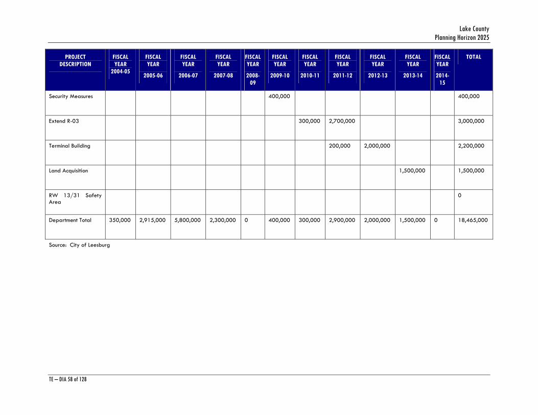
Lake County Planning Horizon 2025
TE – DIA 58 of 128
PROJECT DESCRIPTION
FISCAL YEAR
2004-05
FISCAL YEAR
2005-06
FISCAL YEAR
2006-07
FISCAL YEAR
2007-08
FISCAL YEAR
2008-09
FISCAL YEAR
2009-10
FISCAL YEAR
2010-11
FISCAL YEAR
2011-12
FISCAL YEAR
2012-13
FISCAL YEAR
2013-14
FISCAL YEAR
2014-15
TOTAL
Security Measures 400,000 400,000
Extend R-03 300,000 2,700,000 3,000,000
Terminal Building 200,000 2,000,000 2,200,000
Land Acquisition 1,500,000 1,500,000
RW 13/31 Safety Area
0
Department Total 350,000 2,915,000 5,800,000 2,300,000 0 400,000 300,000 2,900,000 2,000,000 1,500,000 0 18,465,000
Source: City of Leesburg
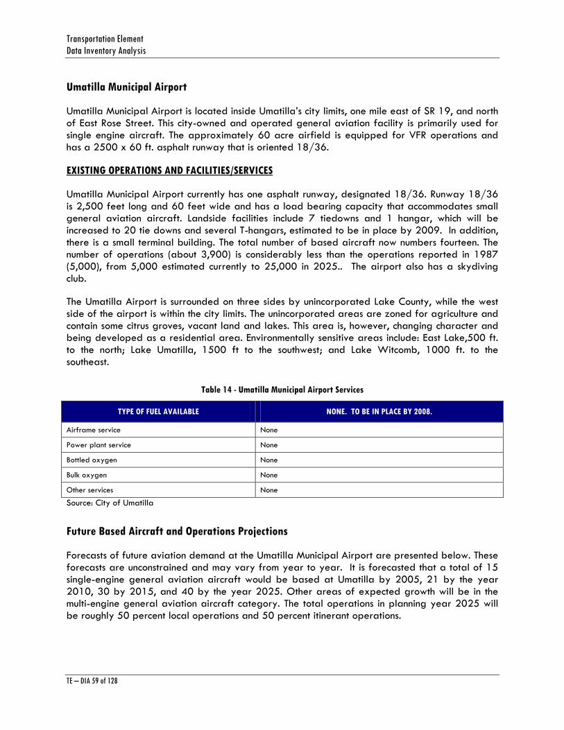
Transportation Element Data Inventory Analysis
TE – DIA 59 of 128
Umatilla Municipal Airport
Umatilla Municipal Airport is located inside Umatilla’s city limits, one mile east of SR 19, and north of East Rose Street. This city-owned and operated general aviation facility is primarily used for single engine aircraft. The approximately 60 acre airfield is equipped for VFR operations and has a 2500 x 60 ft. asphalt runway that is oriented 18/36.
EXISTING OPERATIONS AND FACILITIES/SERVICES
Umatilla Municipal Airport currently has one asphalt runway, designated 18/36. Runway 18/36 is 2,500 feet long and 60 feet wide and has a load bearing capacity that accommodates small general aviation aircraft. Landside facilities include 7 tiedowns and 1 hangar, which will be increased to 20 tie downs and several T-hangars, estimated to be in place by 2009. In addition, there is a small terminal building. The total number of based aircraft now numbers fourteen. The number of operations (about 3,900) is considerably less than the operations reported in 1987 (5,000), from 5,000 estimated currently to 25,000 in 2025.. The airport also has a skydiving club.
The Umatilla Airport is surrounded on three sides by unincorporated Lake County, while the west side of the airport is within the city limits. The unincorporated areas are zoned for agriculture and contain some citrus groves, vacant land and lakes. This area is, however, changing character and being developed as a residential area. Environmentally sensitive areas include: East Lake,500 ft. to the north; Lake Umatilla, 1500 ft to the southwest; and Lake Witcomb, 1000 ft. to the southeast.
Table 14 - Umatilla Municipal Airport Services
TYPE OF FUEL AVAILABLE NONE. TO BE IN PLACE BY 2008.
Airframe service None
Power plant service None
Bottled oxygen None
Bulk oxygen None
Other services None
Source: City of Umatilla
Future Based Aircraft and Operations Projections
Forecasts of future aviation demand at the Umatilla Municipal Airport are presented below. These forecasts are unconstrained and may vary from year to year. It is forecasted that a total of 15 single-engine general aviation aircraft would be based at Umatilla by 2005, 21 by the year 2010, 30 by 2015, and 40 by the year 2025. Other areas of expected growth will be in the multi-engine general aviation aircraft category. The total operations in planning year 2025 will be roughly 50 percent local operations and 50 percent itinerant operations.

Lake County Planning Horizon 2025
TE – DIA 60 of 128
Airport Operations Forecast Summary:
Table 15 - Umatilla Municipal Airport Operations Forecast Summary
1998 2005 2010 2015 2025
Annual Operations Projections are based on the Average Annual Growth Rate (1.7%)
Local 2,000 2,520 4,000 6,000 10,000
Itinerant 1,900 2,480 4,000 6,000 10,000
Total 3,900 5,000 8,000 12,000 20,000
Based Aircraft Projections are based on Socioeconomic-Population Methodology
Single-engine 13 15 21 30 40
Multiengine 2 2 3 4 4
Jet 0 0 0 0 0
Helicopter 0 0 1 1 1
Total 16 18 26 34 70
Source: Reynolds, Smith and Hills, Inc and the City of Umatilla. Numbers are rough estimates, and will change.
Table 16 - Umatilla Municipal Airport Operational Statistics
Average aircraft operations 96/week
Percentage of local general aviation 60%
Percentage of general transient aviation 40%
Source: City of Umatilla
Planned Improvements
In order for Umatilla Municipal Airport to meet the projected demand, it will require significant landside and airside development. The table below summarizes the identified facility requirements contained in the Umatilla Municipal Airport Master Plan:
Table 17 - Umatilla Airport Planned Improvements Summary
ITEM 2000-2005 2006-2010 2011-2025
Airside:
Runway 18/36 2,500-feet x 60-feet 2,500-feet x 60-feet 2,800 feet x 60-feet
Taxiway Partial Partial Partial
Lighting MIRL MIRL MIRL
NAVAIDS Precision Approach Path Indicator (PAPI), Wind Direction Indicator, Rotating Beacon
Precision Approach Path Indicator (PAPI), Wind Direction Indicator, Rotating Beacon
Precision Approach Path Indicator PAPI), Wind Direction Indicator, Rotating Beacon
Landside:
General Aviation 250 square-feet. Pilot Lounge 350 square-feet 500 square-feet

Transportation Element Data Inventory Analysis
TE – DIA 61 of 128
ITEM 2000-2005 2006-2010 2011-2025
Terminal
FBO Area Improved Improved Improved
T-Hangar Spaces None 10 25
Conventional Hangar Spaces
Seven Additional Additional
Fuel None 12,000 gallons 24,000 gallons
Source: Reynolds, Smith and Hills, Inc and the City of Umatilla
Also, the above table identifies the general facility requirements to meet 20-year aviation demand. These facility requirements are approximate based upon the forecast of aviation activity.
FUNDING SOURCES FOR UMATILLA MUNICIPAL AIRPORT:
The potential funding sources for the Capital Improvement Program include Florida Department of Transportation (FDOT) grant funds, FAA grant funds, local/city funds, private funds and other funds. These sources are discussed in the following section
1. FDOT Funding: The State of Florida provides funding to public airport sponsors for eligible projects through the FDOT, Aviation office. Aviation user taxes are used to support eligible aviation developments at the airports. FDOT can fund up to 80 percent of eligible projects not supported by FAA and actually provides more funding statewide then is received from FAA for Florida’s airports, especially general aviation and reliever airports.
2. FAA Funding: Under the current law, airport sponsors are eligible for FAA funding for specifically approved airport projects through the Airport Improvement Program (AIP). AIP provides entitlement funds for commercial service airports based on the number of annual enplaned passengers. Other allocations of AIP dollars go to general aviation and reliever airports, state Departments of Transportation, and national noise compatibility planning programs. Since Umatilla Municipal Airport has few based aircraft, FAA funding is included in the CIP in the last phase since activity at the airport will be increased.
3. Local/City Funds: The City of Umatilla (and revenue from airport operations) has historically provided local funding to the airport for operations and annual maintenance. It is expected that the city will continue to support the airport.
4. County: Lake County may provide funding for particular projects, based on the needs.
5. Other Funding Options: The other funding options include other federal and state grant sources such as economic development funds and intermodal transportation funds. Intermodal Transportation funds can be used to connect highways with other transportation facilities and create intermodal facilities.
Lake County Planning Horizon 2025
TE – DIA 62 of 128
UMATILLA MUNICIPAL AIRPORT IMPROVEMENT SCHEDULE
Capital improvements to Umatilla Municipal Airport will be phased in as outlined in the table below.
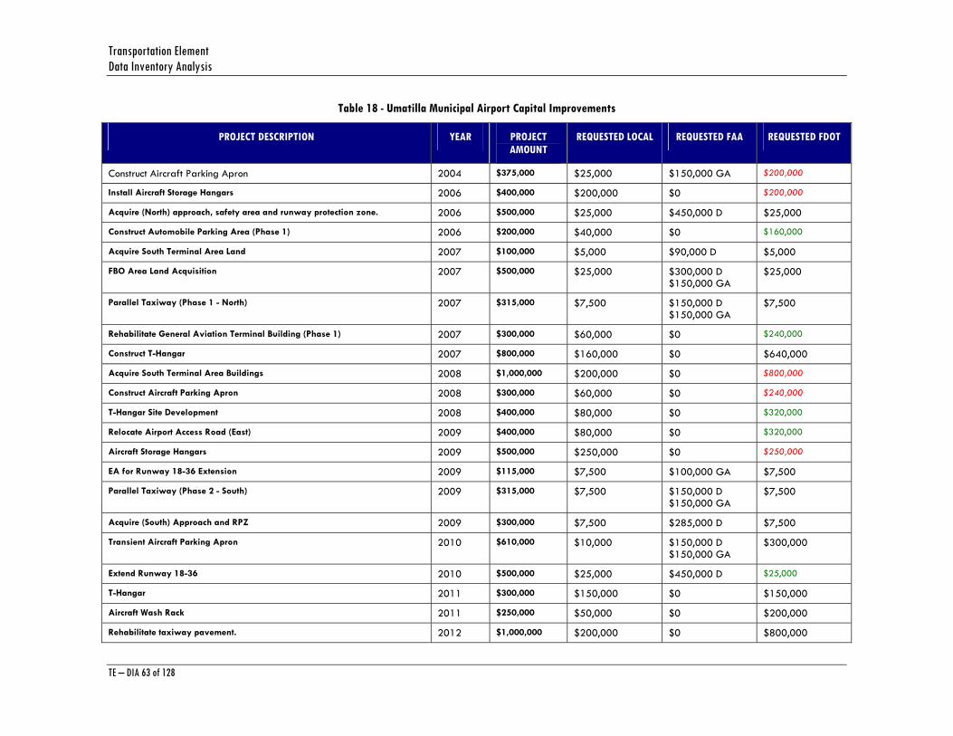
Transportation Element Data Inventory Analysis
TE – DIA 63 of 128
Table 18 - Umatilla Municipal Airport Capital Improvements
PROJECT DESCRIPTION YEAR PROJECT AMOUNT
REQUESTED LOCAL REQUESTED FAA REQUESTED FDOT
Construct Aircraft Parking Apron 2004 $375,000 $25,000 $150,000 GA $200,000
Install Aircraft Storage Hangars 2006 $400,000 $200,000 $0 $200,000
Acquire (North) approach, safety area and runway protection zone. 2006 $500,000 $25,000 $450,000 D $25,000
Construct Automobile Parking Area (Phase 1) 2006 $200,000 $40,000 $0 $160,000
Acquire South Terminal Area Land 2007 $100,000 $5,000 $90,000 D $5,000
FBO Area Land Acquisition 2007 $500,000 $25,000 $300,000 D $150,000 GA
$25,000
Parallel Taxiway (Phase 1 - North) 2007 $315,000 $7,500 $150,000 D $150,000 GA
$7,500
Rehabilitate General Aviation Terminal Building (Phase 1) 2007 $300,000 $60,000 $0 $240,000
Construct T-Hangar 2007 $800,000 $160,000 $0 $640,000
Acquire South Terminal Area Buildings 2008 $1,000,000 $200,000 $0 $800,000
Construct Aircraft Parking Apron 2008 $300,000 $60,000 $0 $240,000
T-Hangar Site Development 2008 $400,000 $80,000 $0 $320,000
Relocate Airport Access Road (East) 2009 $400,000 $80,000 $0 $320,000
Aircraft Storage Hangars 2009 $500,000 $250,000 $0 $250,000
EA for Runway 18-36 Extension 2009 $115,000 $7,500 $100,000 GA $7,500
Parallel Taxiway (Phase 2 - South) 2009 $315,000 $7,500 $150,000 D $150,000 GA
$7,500
Acquire (South) Approach and RPZ 2009 $300,000 $7,500 $285,000 D $7,500
Transient Aircraft Parking Apron 2010 $610,000 $10,000 $150,000 D $150,000 GA
$300,000
Extend Runway 18-36 2010 $500,000 $25,000 $450,000 D $25,000
T-Hangar 2011 $300,000 $150,000 $0 $150,000
Aircraft Wash Rack 2011 $250,000 $50,000 $0 $200,000
Rehabilitate taxiway pavement. 2012 $1,000,000 $200,000 $0 $800,000
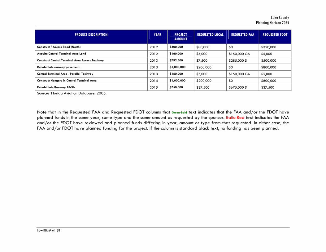
Lake County Planning Horizon 2025
TE – DIA 64 of 128
PROJECT DESCRIPTION YEAR PROJECT AMOUNT
REQUESTED LOCAL REQUESTED FAA REQUESTED FDOT
Construct / Access Road (North) 2012 $400,000 $80,000 $0 $320,000
Acquire Central Terminal Area Land 2012 $160,000 $5,000 $150,000 GA $5,000
Construct Central Terminal Area Access Taxiway 2013 $792,500 $7,500 $285,000 D $500,000
Rehabilitate runway pavement. 2013 $1,000,000 $200,000 $0 $800,000
Central Terminal Area - Parallel Taxiway 2013 $160,000 $5,000 $150,000 GA $5,000
Construct Hangars in Central Terminal Area. 2014 $1,000,000 $200,000 $0 $800,000
Rehabilitate Runway 18-36 2015 $750,000 $37,500 $675,000 D $37,500
Source: Florida Aviation Database, 2005.
Note that in the Requested FAA and Requested FDOT columns that Green-Bold text indicates that the FAA and/or the FDOT have planned funds in the same year, same type and the same amount as requested by the sponsor. Italic-Red text indicates the FAA and/or the FDOT have reviewed and planned funds differing in year, amount or type from that requested. In either case, the FAA and/or FDOT have planned funding for the project. If the column is standard black text, no funding has been planned.
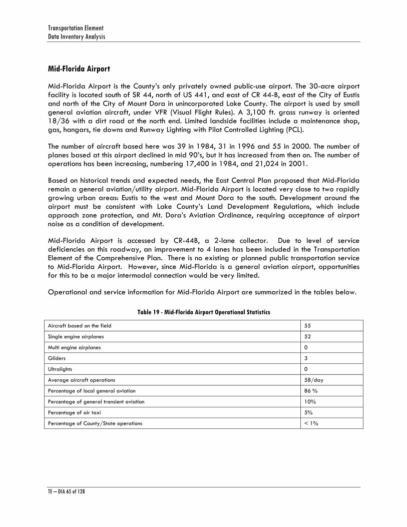
Transportation Element Data Inventory Analysis
TE – DIA 65 of 128
Mid-Florida Airport
Mid-Florida Airport is the County’s only privately owned public-use airport. The 30-acre airport facility is located south of SR 44, north of US 441, and east of CR 44-B, east of the City of Eustis and north of the City of Mount Dora in unincorporated Lake County. The airport is used by small general aviation aircraft, under VFR (Visual Flight Rules). A 3,100 ft. grass runway is oriented 18/36 with a dirt road at the north end. Limited landside facilities include a maintenance shop, gas, hangars, tie downs and Runway Lighting with Pilot Controlled Lighting (PCL).
The number of aircraft based here was 39 in 1984, 31 in 1996 and 55 in 2000. The number of planes based at this airport declined in mid 90’s, but it has increased from then on. The number of operations has been increasing, numbering 17,400 in 1984, and 21,024 in 2001.
Based on historical trends and expected needs, the East Central Plan proposed that Mid-Florida remain a general aviation/utility airport. Mid-Florida Airport is located very close to two rapidly growing urban areas: Eustis to the west and Mount Dora to the south. Development around the airport must be consistent with Lake County’s Land Development Regulations, which include approach zone protection, and Mt. Dora’s Aviation Ordinance, requiring acceptance of airport noise as a condition of development.
Mid-Florida Airport is accessed by CR-44B, a 2-lane collector. Due to level of service deficiencies on this roadway, an improvement to 4 lanes has been included in the Transportation Element of the Comprehensive Plan. There is no existing or planned public transportation service to Mid-Florida Airport. However, since Mid-Florida is a general aviation airport, opportunities for this to be a major intermodal connection would be very limited.
Operational and service information for Mid-Florida Airport are summarized in the tables below.
Table 19 - Mid-Florida Airport Operational Statistics
Aircraft based on the field 55
Single engine airplanes 52
Multi engine airplanes 0
Gliders 3
Ultralights 0
Average aircraft operations 58/day
Percentage of local general aviation 86 %
Percentage of general transient aviation 10%
Percentage of air taxi 5%
Percentage of County/State operations < 1%
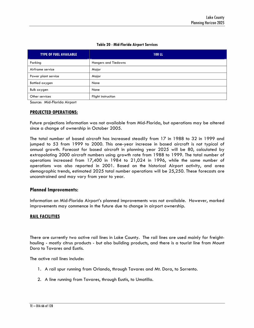
Lake County Planning Horizon 2025
TE – DIA 66 of 128
Table 20 - Mid-Florida Airport Services
TYPE OF FUEL AVAILABLE 100 LL
Parking Hangers and Tiedowns
Airframe service Major
Power plant service Major
Bottled oxygen None
Bulk oxygen None
Other services Flight instruction
Source: Mid-Florida Airport
PROJECTED OPERATIONS:
Future projections information was not available from Mid-Florida, but operations may be altered since a change of ownership in October 2005.
The total number of based aircraft has increased steadily from 17 in 1988 to 32 in 1999 and jumped to 53 from 1999 to 2000. This one-year increase in based aircraft is not typical of annual growth. Forecast for based aircraft in planning year 2025 will be 80, calculated by extrapolating 2000 aircraft numbers using growth rate from 1988 to 1999. The total number of operations increased from 17,400 in 1984 to 21,024 in 1996, while the same number of operations was also reported in 2001. Based on the historical Airport activity, and area demographic trends, estimated 2025 total number operations will be 25,250. These forecasts are unconstrained and may vary from year to year.
Planned Improvements:
Information on Mid-Florida Airport’s planned improvements was not available. However, marked improvements may commence in the future due to change in airport ownership.
RAIL FACILITIES
There are currently two active rail lines in Lake County. The rail lines are used mainly for freight-hauling - mostly citrus products - but also building products, and there is a tourist line from Mount Dora to Tavares and Eustis.
The active rail lines include:
1. A rail spur running from Orlando, through Tavares and Mt. Dora, to Sorrento.
2. A line running from Tavares, through Eustis, to Umatilla.

Transportation Element Data Inventory Analysis
TE – DIA 67 of 128
These lines are generally short-haul lines or spurs. There are no known plans to discontinue use of these lines.
The use of rail by business and industry to move freight is a benefit to other transportation system users, as it reduces the number of medium and heavy trucks using already congested roadways. Therefore, business and industry in Lake County should be encouraged to use rail, to the extent feasible, for freight movement.
Lake County Planning Horizon 2025
TE – DIA 68 of 128
APPENDIX A 2006-2010 Lake County Construction Program
Source: Lake County Public Works,
Special Services Division
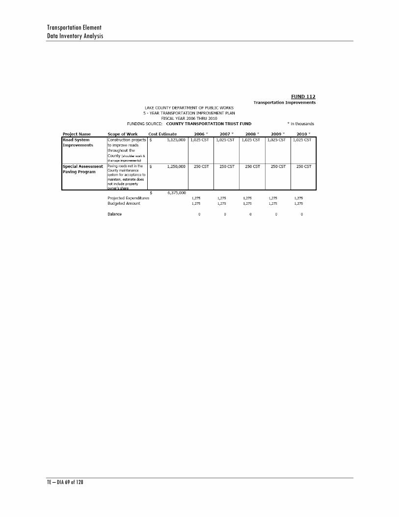
Transportation Element Data Inventory Analysis
TE – DIA 69 of 128
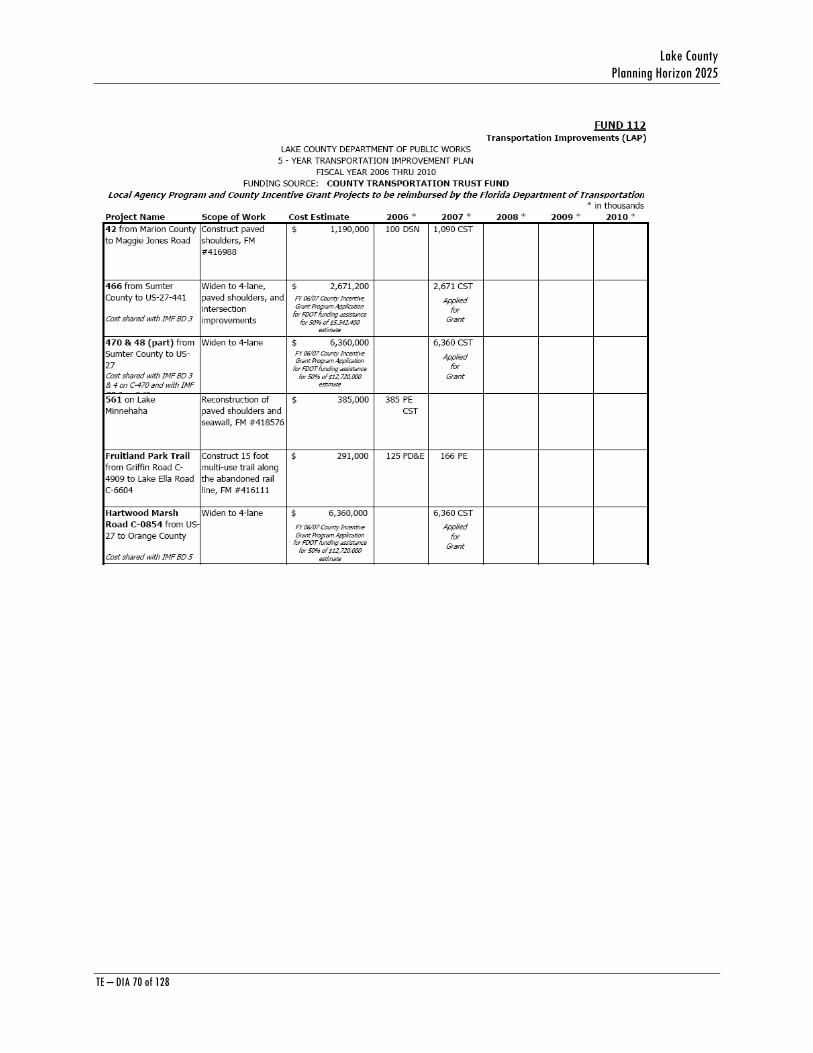
Lake County Planning Horizon 2025
TE – DIA 70 of 128
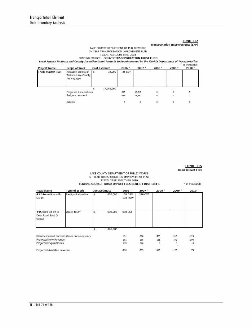
Transportation Element Data Inventory Analysis
TE – DIA 71 of 128
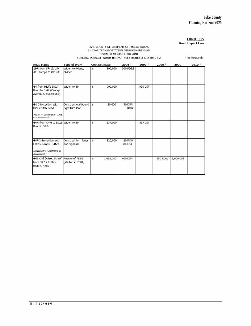
Lake County Planning Horizon 2025
TE – DIA 72 of 128
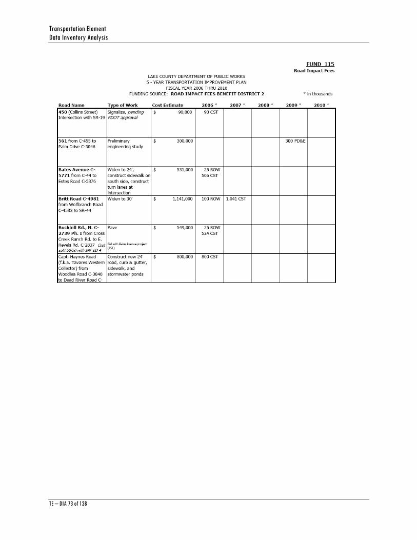
Transportation Element Data Inventory Analysis
TE – DIA 73 of 128

Lake County Planning Horizon 2025
TE – DIA 74 of 128
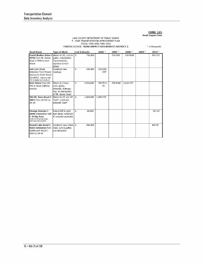
Transportation Element Data Inventory Analysis
TE – DIA 75 of 128

Lake County Planning Horizon 2025
TE – DIA 76 of 128

Transportation Element Data Inventory Analysis
TE – DIA 77 of 128
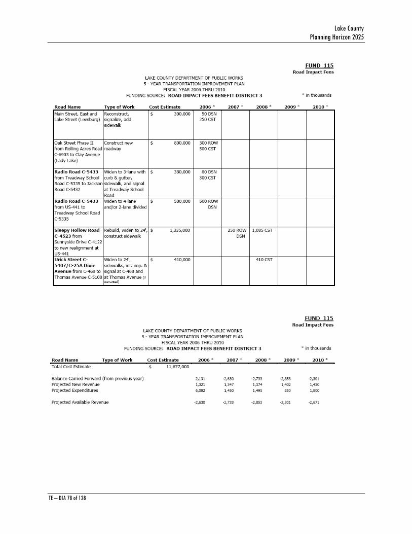
Lake County Planning Horizon 2025
TE – DIA 78 of 128
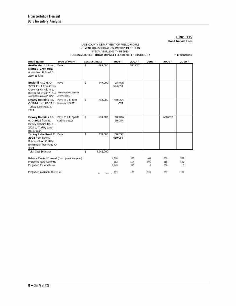
Transportation Element Data Inventory Analysis
TE – DIA 79 of 128
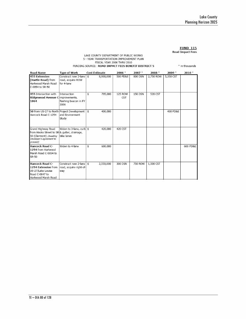
Lake County Planning Horizon 2025
TE – DIA 80 of 128

Transportation Element Data Inventory Analysis
TE – DIA 81 of 128
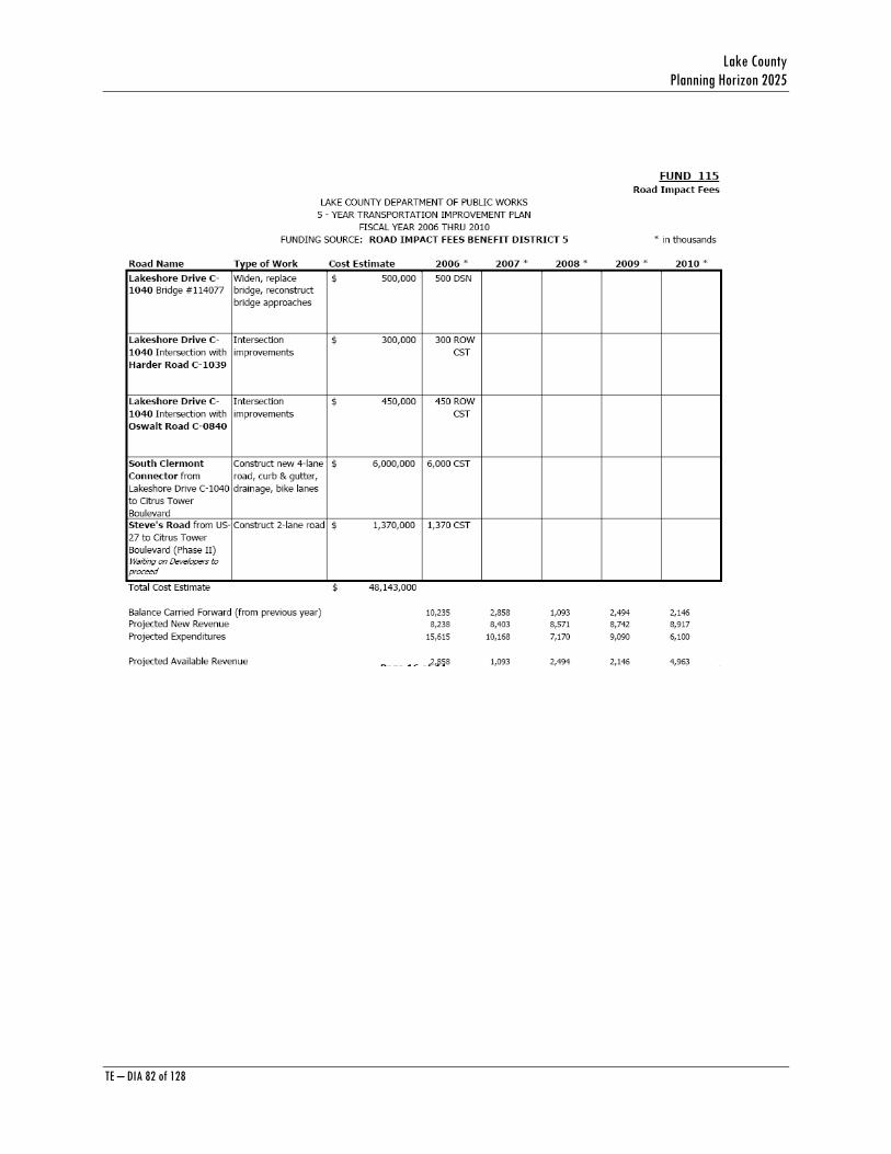
Lake County Planning Horizon 2025
TE – DIA 82 of 128
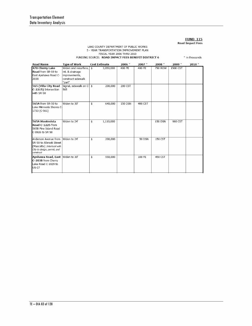
Transportation Element Data Inventory Analysis
TE – DIA 83 of 128
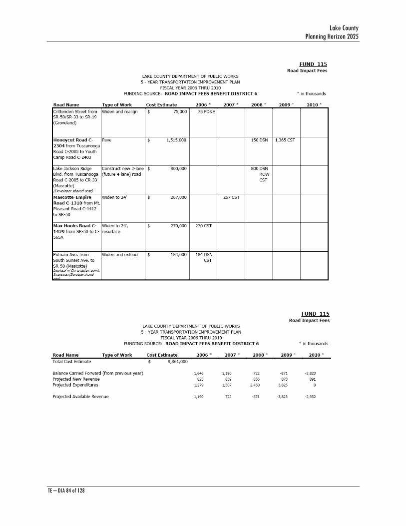
Lake County Planning Horizon 2025
TE – DIA 84 of 128
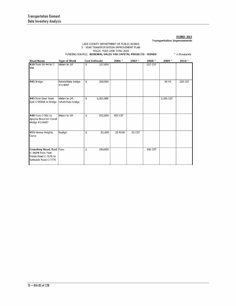
Transportation Element Data Inventory Analysis
TE – DIA 85 of 128
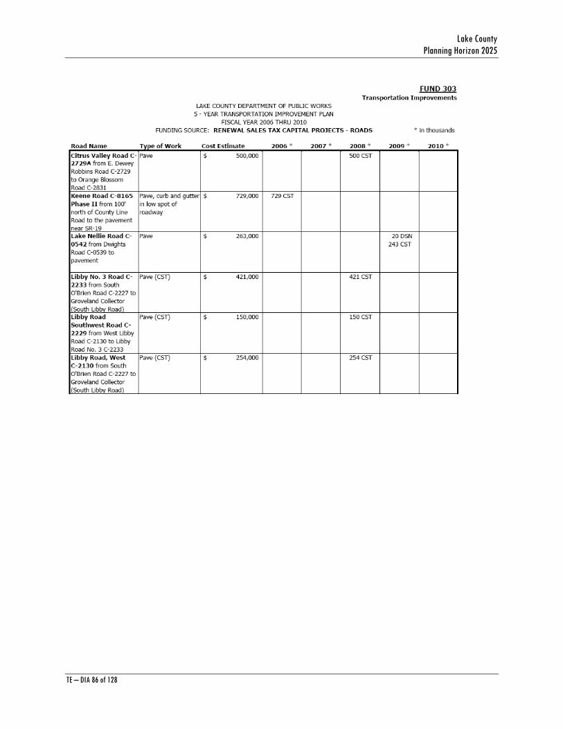
Lake County Planning Horizon 2025
TE – DIA 86 of 128

Transportation Element Data Inventory Analysis
TE – DIA 87 of 128

Lake County Planning Horizon 2025
TE – DIA 88 of 128

Transportation Element Data Inventory Analysis
TE – DIA 89 of 128

Lake County Planning Horizon 2025
TE – DIA 90 of 128
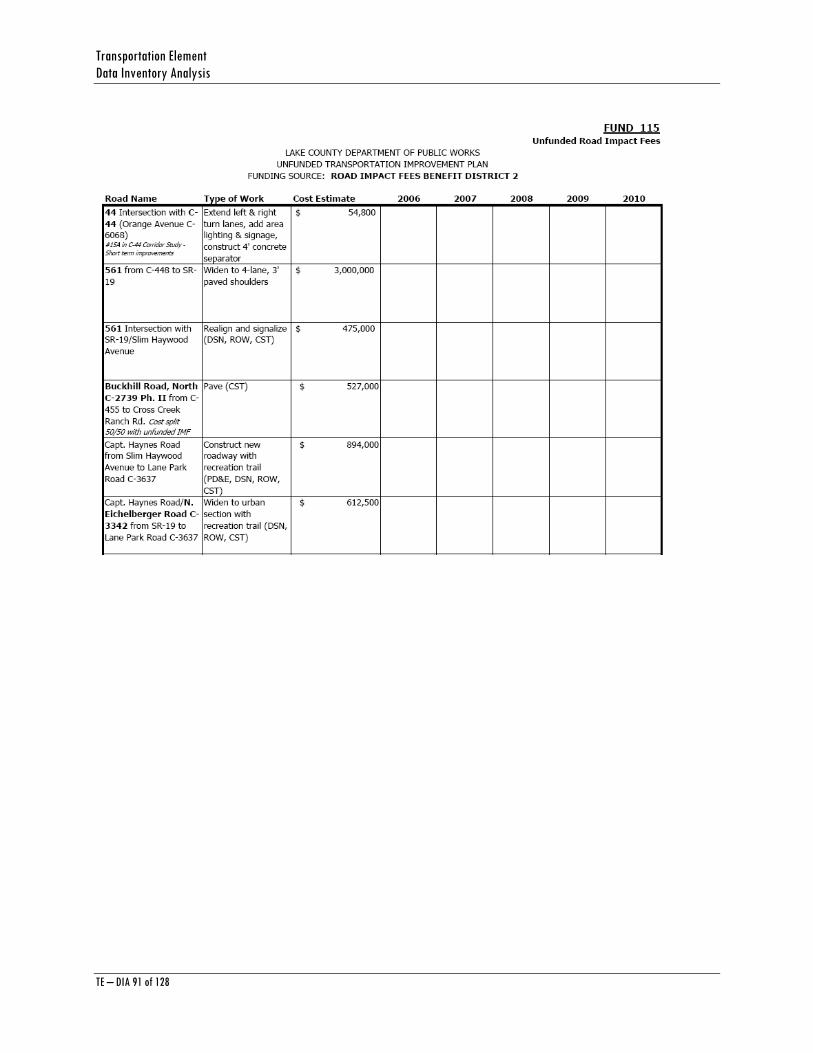
Transportation Element Data Inventory Analysis
TE – DIA 91 of 128
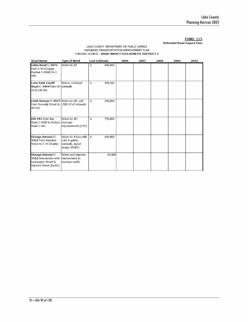
Lake County Planning Horizon 2025
TE – DIA 92 of 128
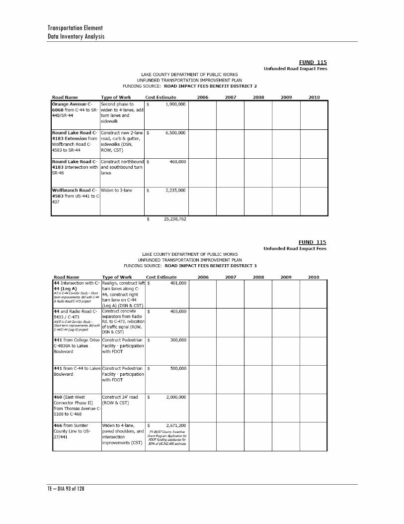
Transportation Element Data Inventory Analysis
TE – DIA 93 of 128

Lake County Planning Horizon 2025
TE – DIA 94 of 128

Transportation Element Data Inventory Analysis
TE – DIA 95 of 128
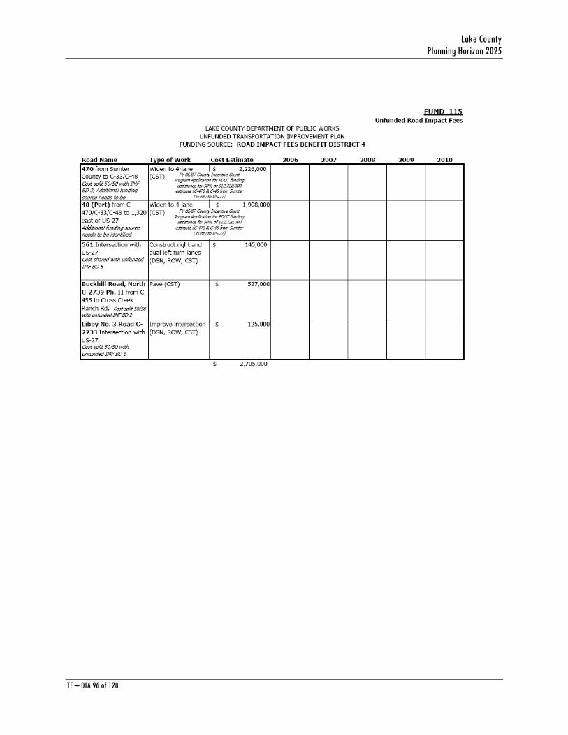
Lake County Planning Horizon 2025
TE – DIA 96 of 128
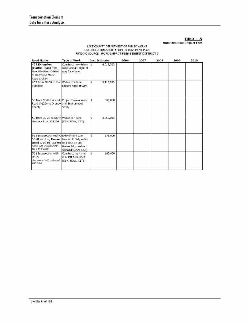
Transportation Element Data Inventory Analysis
TE – DIA 97 of 128
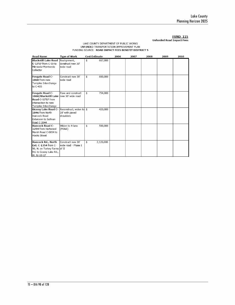
Lake County Planning Horizon 2025
TE – DIA 98 of 128
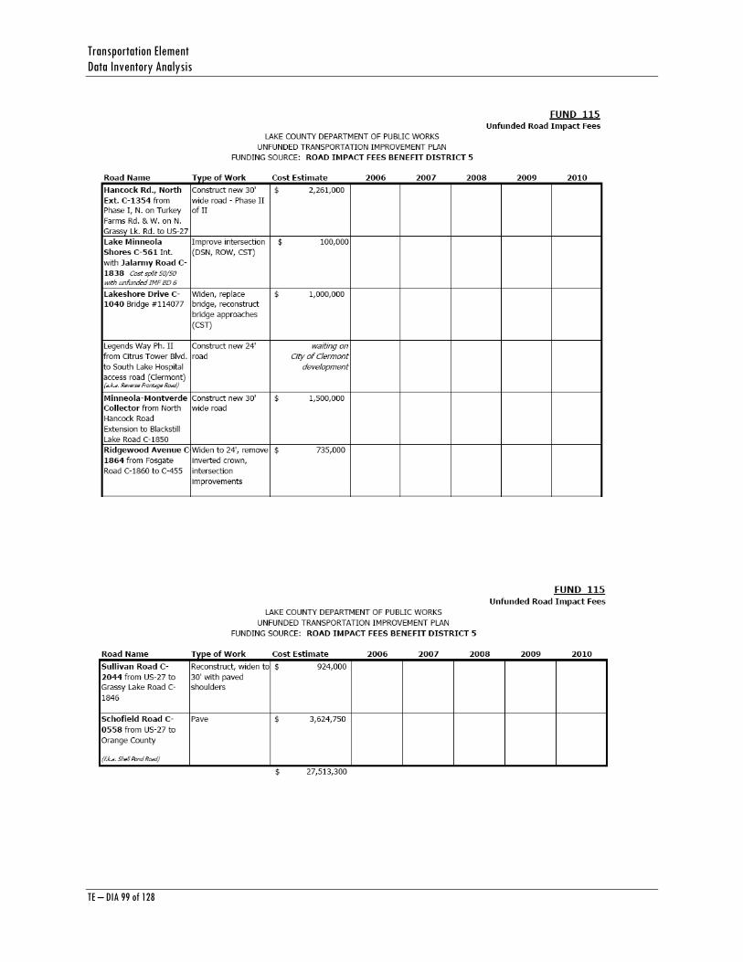
Transportation Element Data Inventory Analysis
TE – DIA 99 of 128
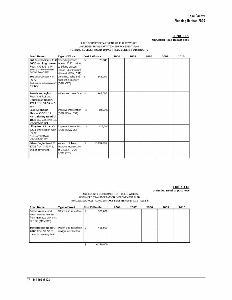
Lake County Planning Horizon 2025
TE – DIA 100 of 128
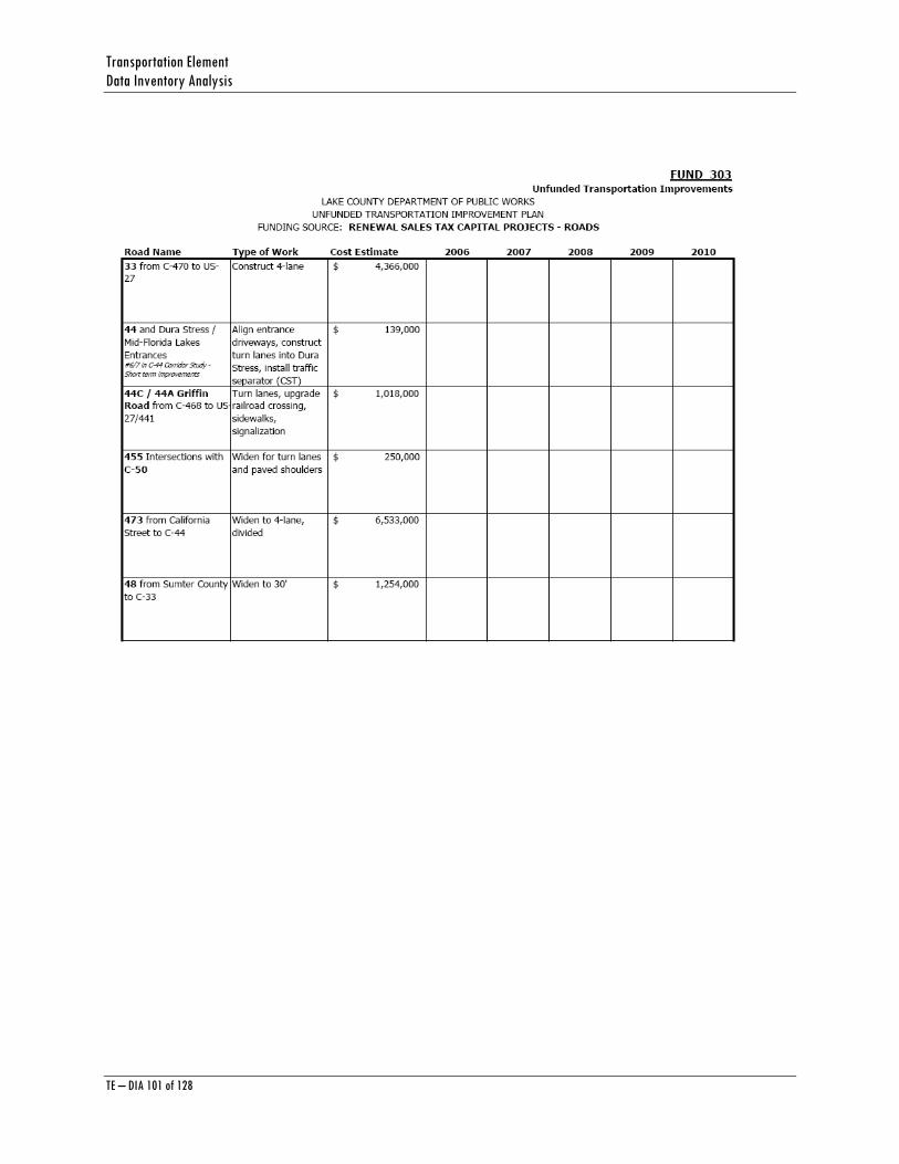
Transportation Element Data Inventory Analysis
TE – DIA 101 of 128
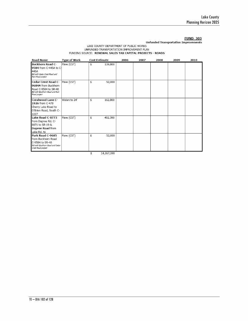
Lake County Planning Horizon 2025
TE – DIA 102 of 128

Transportation Element Data Inventory Analysis
TE – DIA 103 of 128
Lake County Planning Horizon 2025
TE – DIA 104 of 128
APPENDIX B Lake County Five (5) Year Transportation Improvement Program (TIP)
Source: Lake-Sumter Metropolitan Planning Organization (MPO)
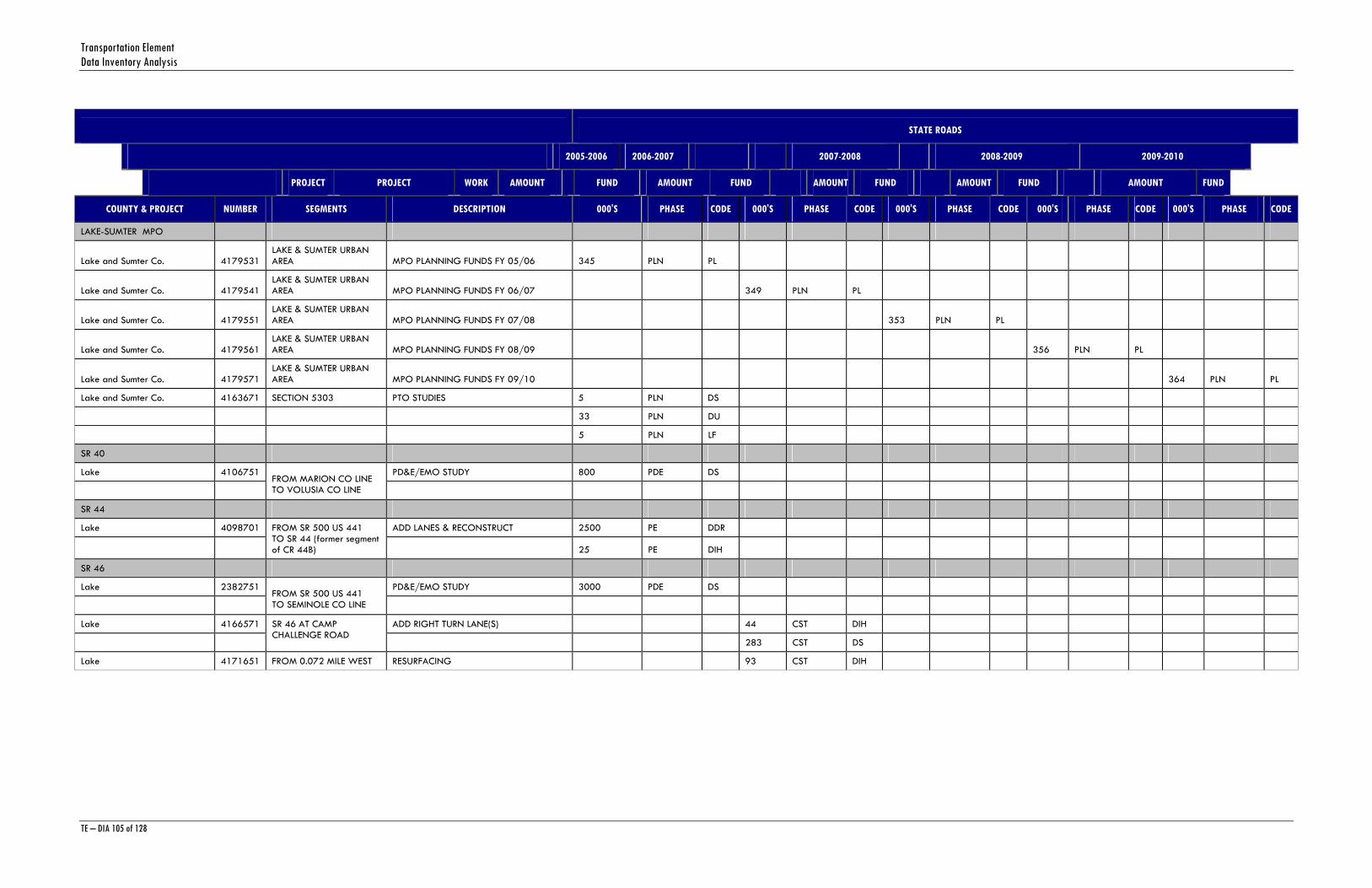
Transportation Element Data Inventory Analysis
TE – DIA 105 of 128
STATE ROADS
2005-2006 2006-2007 2007-2008 2008-2009 2009-2010
PROJECT PROJECT WORK AMOUNT FUND AMOUNT FUND AMOUNT FUND AMOUNT FUND AMOUNT FUND
COUNTY & PROJECT NUMBER SEGMENTS DESCRIPTION 000'S PHASE CODE 000'S PHASE CODE 000'S PHASE CODE 000'S PHASE CODE 000'S PHASE CODE
LAKE-SUMTER MPO
Lake and Sumter Co. 4179531 LAKE & SUMTER URBAN AREA MPO PLANNING FUNDS FY 05/06 345 PLN PL
Lake and Sumter Co. 4179541 LAKE & SUMTER URBAN AREA MPO PLANNING FUNDS FY 06/07 349 PLN PL
Lake and Sumter Co. 4179551 LAKE & SUMTER URBAN AREA MPO PLANNING FUNDS FY 07/08 353 PLN PL
Lake and Sumter Co. 4179561 LAKE & SUMTER URBAN AREA MPO PLANNING FUNDS FY 08/09 356 PLN PL
Lake and Sumter Co. 4179571 LAKE & SUMTER URBAN AREA MPO PLANNING FUNDS FY 09/10 364 PLN PL
Lake and Sumter Co. 4163671 SECTION 5303 PTO STUDIES 5 PLN DS
33 PLN DU
5 PLN LF
SR 40
Lake 4106751 PD&E/EMO STUDY 800 PDE DS
FROM MARION CO LINE TO VOLUSIA CO LINE
SR 44
Lake 4098701 ADD LANES & RECONSTRUCT 2500 PE DDR
FROM SR 500 US 441 TO SR 44 (former segment of CR 44B) 25 PE DIH
SR 46
Lake 2382751 PD&E/EMO STUDY 3000 PDE DS
FROM SR 500 US 441 TO SEMINOLE CO LINE
Lake 4166571 ADD RIGHT TURN LANE(S) 44 CST DIH
SR 46 AT CAMP CHALLENGE ROAD
283 CST DS
Lake 4171651 FROM 0.072 MILE WEST RESURFACING 93 CST DIH
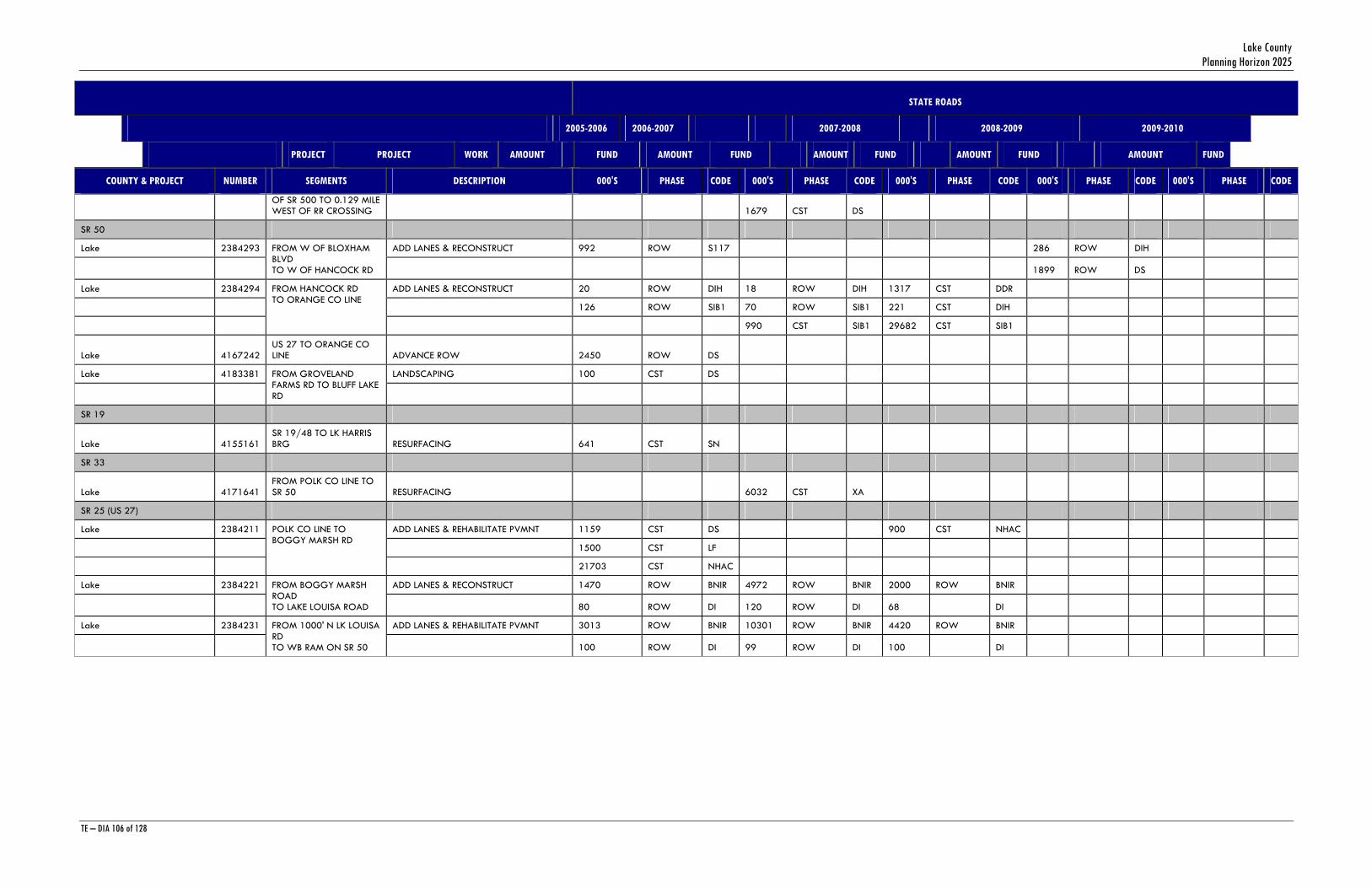
Lake County Planning Horizon 2025
TE – DIA 106 of 128
STATE ROADS
2005-2006 2006-2007 2007-2008 2008-2009 2009-2010
PROJECT PROJECT WORK AMOUNT FUND AMOUNT FUND AMOUNT FUND AMOUNT FUND AMOUNT FUND
COUNTY & PROJECT NUMBER SEGMENTS DESCRIPTION 000'S PHASE CODE 000'S PHASE CODE 000'S PHASE CODE 000'S PHASE CODE 000'S PHASE CODE
OF SR 500 TO 0.129 MILE WEST OF RR CROSSING 1679 CST DS
SR 50
Lake 2384293 ADD LANES & RECONSTRUCT 992 ROW S117 286 ROW DIH
FROM W OF BLOXHAM BLVD TO W OF HANCOCK RD 1899 ROW DS
Lake 2384294 ADD LANES & RECONSTRUCT 20 ROW DIH 18 ROW DIH 1317 CST DDR
126 ROW SIB1 70 ROW SIB1 221 CST DIH
FROM HANCOCK RD TO ORANGE CO LINE
990 CST SIB1 29682 CST SIB1
Lake 4167242 US 27 TO ORANGE CO LINE ADVANCE ROW 2450 ROW DS
Lake 4183381 LANDSCAPING 100 CST DS
FROM GROVELAND FARMS RD TO BLUFF LAKE RD
SR 19
Lake 4155161 SR 19/48 TO LK HARRIS BRG RESURFACING 641 CST SN
SR 33
Lake 4171641 FROM POLK CO LINE TO SR 50 RESURFACING 6032 CST XA
SR 25 (US 27)
Lake 2384211 ADD LANES & REHABILITATE PVMNT 1159 CST DS 900 CST NHAC
1500 CST LF
POLK CO LINE TO BOGGY MARSH RD
21703 CST NHAC
Lake 2384221 ADD LANES & RECONSTRUCT 1470 ROW BNIR 4972 ROW BNIR 2000 ROW BNIR
FROM BOGGY MARSH ROAD TO LAKE LOUISA ROAD 80 ROW DI 120 ROW DI 68 DI
Lake 2384231 ADD LANES & REHABILITATE PVMNT 3013 ROW BNIR 10301 ROW BNIR 4420 ROW BNIR
FROM 1000' N LK LOUISA RD TO WB RAM ON SR 50 100 ROW DI 99 ROW DI 100 DI
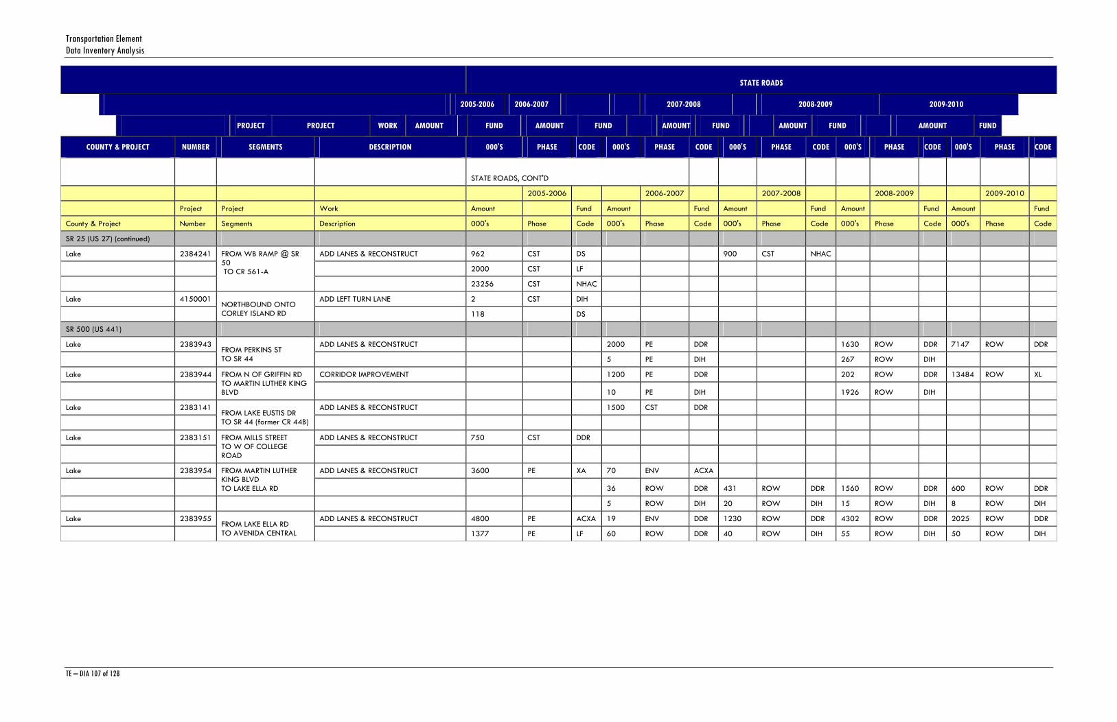
Transportation Element Data Inventory Analysis
TE – DIA 107 of 128
STATE ROADS
2005-2006 2006-2007 2007-2008 2008-2009 2009-2010
PROJECT PROJECT WORK AMOUNT FUND AMOUNT FUND AMOUNT FUND AMOUNT FUND AMOUNT FUND
COUNTY & PROJECT NUMBER SEGMENTS DESCRIPTION 000'S PHASE CODE 000'S PHASE CODE 000'S PHASE CODE 000'S PHASE CODE 000'S PHASE CODE
STATE ROADS, CONT'D
2005-2006 2006-2007 2007-2008 2008-2009 2009-2010
Project Project Work Amount Fund Amount Fund Amount Fund Amount Fund Amount Fund
County & Project Number Segments Description 000's Phase Code 000's Phase Code 000's Phase Code 000's Phase Code 000's Phase Code
SR 25 (US 27) (continued)
Lake 2384241 ADD LANES & RECONSTRUCT 962 CST DS 900 CST NHAC
2000 CST LF
FROM WB RAMP @ SR 50 TO CR 561-A
23256 CST NHAC
Lake 4150001 ADD LEFT TURN LANE 2 CST DIH
NORTHBOUND ONTO CORLEY ISLAND RD 118 DS
SR 500 (US 441)
Lake 2383943 ADD LANES & RECONSTRUCT 2000 PE DDR 1630 ROW DDR 7147 ROW DDR
FROM PERKINS ST TO SR 44 5 PE DIH 267 ROW DIH
Lake 2383944 CORRIDOR IMPROVEMENT 1200 PE DDR 202 ROW DDR 13484 ROW XL
FROM N OF GRIFFIN RD TO MARTIN LUTHER KING BLVD 10 PE DIH 1926 ROW DIH
Lake 2383141 ADD LANES & RECONSTRUCT 1500 CST DDR
FROM LAKE EUSTIS DR TO SR 44 (former CR 44B)
Lake 2383151 ADD LANES & RECONSTRUCT 750 CST DDR
FROM MILLS STREET TO W OF COLLEGE ROAD
Lake 2383954 ADD LANES & RECONSTRUCT 3600 PE XA 70 ENV ACXA
FROM MARTIN LUTHER KING BLVD TO LAKE ELLA RD 36 ROW DDR 431 ROW DDR 1560 ROW DDR 600 ROW DDR
5 ROW DIH 20 ROW DIH 15 ROW DIH 8 ROW DIH
Lake 2383955 ADD LANES & RECONSTRUCT 4800 PE ACXA 19 ENV DDR 1230 ROW DDR 4302 ROW DDR 2025 ROW DDR
FROM LAKE ELLA RD TO AVENIDA CENTRAL 1377 PE LF 60 ROW DDR 40 ROW DIH 55 ROW DIH 50 ROW DIH

Lake County Planning Horizon 2025
TE – DIA 108 of 128
STATE ROADS
2005-2006 2006-2007 2007-2008 2008-2009 2009-2010
PROJECT PROJECT WORK AMOUNT FUND AMOUNT FUND AMOUNT FUND AMOUNT FUND AMOUNT FUND
COUNTY & PROJECT NUMBER SEGMENTS DESCRIPTION 000'S PHASE CODE 000'S PHASE CODE 000'S PHASE CODE 000'S PHASE CODE 000'S PHASE CODE
Lake 2383942 INTERSECTION (MAJOR) 50 ROW DIH 100 ROW DIH 21 ROW DIH 295 CST LF
FROM PERKINS STREET TO N OF GRIFFIN RD 4748 ROW XA 3804 ROW XA 2142 ROW XA 8868 CST XA
100 PE DDR
Lake 4171631 RESURFACING 2771 CST XA
FROM EAST OF PERKINS TO WEST OF MILLS STREET
Sumter 2383957 ADD LANES & RECONSTRUCT 505 PE XL
FROM BUENOS AIRES TO MARION CO LINE
Sumter 4169071 INTERSECTION (MINOR) 180 CST
US 27 FROM SOUTH OF NE 138TH AVE TO NORTH OF CR 109
Sumter 2383952 PD&E/EMO STUDY 4 PDE DS
FROM LAKE COUNTY LINE TO MARION COUNTY LINE
SR 91 (FLORIDA'S TURNPIKE)
Lake 4136233 RESURFACING 11 CST PKYI
RESURFACING MP 275.7 TO 281.8 - THERMOPLASTIC SIGNING/PAVEMENT MARKINGS 551 CST PKYR
LOCAL ROADS
2005-2006 2006-2007 2007-2008 2008-2009 2009-2010
Project Project Work Amount Fund Amount Fund Amount Fund Amount Fund Amount Fund
County & Project Number Segments Description 000's Phase Code 000's Phase Code 000's Phase Code 000's Phase Code 000's Phase Code
CR 48
Lake 4154721 PAVE SHOULDERS 841 ADM ACSH
FROM US 27 TO SR 19 841 ADM SH
CR 42
Lake 4169881 PAVE SHOULDERS 100 PE SS
FROM MARION CO LINE TO MAGGIE JONES ROAD 1090 CST SS

Transportation Element Data Inventory Analysis
TE – DIA 109 of 128
STATE ROADS
2005-2006 2006-2007 2007-2008 2008-2009 2009-2010
PROJECT PROJECT WORK AMOUNT FUND AMOUNT FUND AMOUNT FUND AMOUNT FUND AMOUNT FUND
COUNTY & PROJECT NUMBER SEGMENTS DESCRIPTION 000'S PHASE CODE 000'S PHASE CODE 000'S PHASE CODE 000'S PHASE CODE 000'S PHASE CODE
BRIDGES, SIGNALS & DRAINAGE
2005-2006 2006-2007 2007-2008 2008-2009 2009-2010
Project Project Work Amount Fund Amount Fund Amount Fund Amount Fund Amount Fund
County & Project Number Segments Description 000's Phase Code 000's Phase Code 000's Phase Code 000's Phase Code 000's Phase Code
LAKE NORRIS ROAD
Lake 2414441 REPLACE LOW LEVEL BRIDGE 968 CST BZAC
BR#114076 NE LAKE CO 3.2MI N OF CR 44A
SR 50
Lake 4114901 BRIDGE-REPAIR/REHABILITATION 417 CST BRRP
PALATLAKAHA RIVER BR # 110027 4 CST DIH
SR 25 (US 27)
Lake 4086381 REPLACE LOW LEVEL BRIDGE 1704 CST BRAC
1848 CST BRP
BR# 110061 PALATLAKAHA CREEK SOUTHBOUND LANE 2 CST DIH
SR 25/500 (US 27/441)
Lake 4149741 TRAFFIC SIGNALS 79 CST DIH
FROM CITIZENS BLVD TO EAGLES NEST ROAD 707 CST DS
Lake 4102901 DRAINAGE IMPROVEMENTS 7 ROW DIH 49 CST DIH
NORTH OF GRIFFIN RD 1243 ROW DS 327 CST DS
SR 46
Lake 4162181 TRAFFIC SIGNALS 7 ROW DIH 36 CST DIH
FROM CR 437 SOUTH 90 ROW DS 228 CST DS
SR 500 (US 441)
Lake 4161251 US 441 OVER SR 46 BRIDGE #110030 & 110066 1754 CST BRRP

Lake County Planning Horizon 2025
TE – DIA 110 of 128
STATE ROADS
2005-2006 2006-2007 2007-2008 2008-2009 2009-2010
PROJECT PROJECT WORK AMOUNT FUND AMOUNT FUND AMOUNT FUND AMOUNT FUND AMOUNT FUND
COUNTY & PROJECT NUMBER SEGMENTS DESCRIPTION 000'S PHASE CODE 000'S PHASE CODE 000'S PHASE CODE 000'S PHASE CODE 000'S PHASE CODE
97 CST DIH
MISC MAINTENANCE
2005-2006 2006-2007 2007-2008 2008-2009 2009-2010
Project Project Work Amount Fund Amount Fund Amount Fund Amount Fund Amount Fund
County & Project Number Segments Description 000's Phase Code 000's Phase Code 000's Phase Code 000's Phase Code 000's Phase Code
LIGHTING AGREEMENTS
Lake 4136151 DDR FUNDS LIGHTING 69 MNT DDR 60 MNT DDR 62 MNT DDR 64 MNT DDR
SIGNAL MAINTENANCE
Lake 4130193 TRAFFIC SIGNALS 135 OPS DDR 139 OPS DDR 143 OPS DDR 151 OPS DDR 161 OPS DDR
TRAFFIC ENGINEERING CONTRACTS
Sumter 4130198 TRAFFIC SIGNALS 24 OPS DDR 25 OPS DDR 26 OPS DDR 27 OPS DDR 27 OPS DDR
TRAFFIC ENGINEERING CONTRACTS
AESTHETICS
Lake 4157841 ROUTINE MAINTENANCE CONTRACTS 100 MNT D
TREE TRIMMING - VARIOUS LOCATIONS
Lake 4157842 FERTILIZING - VARIOUS LOCATIONS ROUTINE MAINTENANCE CONTRACTS 50 MNT D
AESTHETICS 'MEGA'
Lake 2447542 ROUTINE MAINTENANCE CONTRACTS 833 MNT D 833 MNT D
CC 592 - MOWING, LITTERING, SWEEPING, EDGING
LAKE ROADWAYS
Lake 2441201 ROUTINE MAINTENANCE 3000 MNT D 3000 MNT D
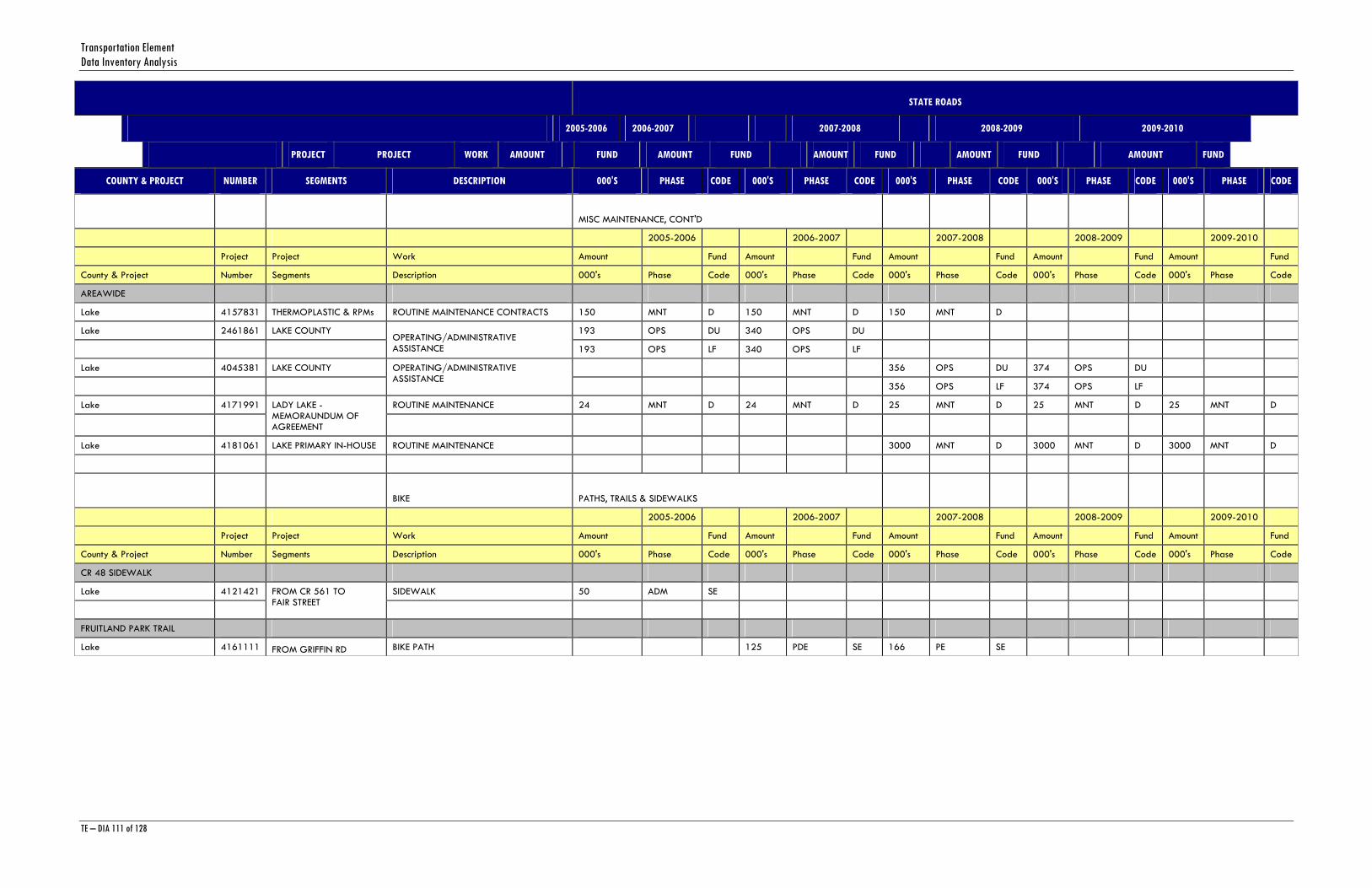
Transportation Element Data Inventory Analysis
TE – DIA 111 of 128
STATE ROADS
2005-2006 2006-2007 2007-2008 2008-2009 2009-2010
PROJECT PROJECT WORK AMOUNT FUND AMOUNT FUND AMOUNT FUND AMOUNT FUND AMOUNT FUND
COUNTY & PROJECT NUMBER SEGMENTS DESCRIPTION 000'S PHASE CODE 000'S PHASE CODE 000'S PHASE CODE 000'S PHASE CODE 000'S PHASE CODE
MISC MAINTENANCE, CONT'D
2005-2006 2006-2007 2007-2008 2008-2009 2009-2010
Project Project Work Amount Fund Amount Fund Amount Fund Amount Fund Amount Fund
County & Project Number Segments Description 000's Phase Code 000's Phase Code 000's Phase Code 000's Phase Code 000's Phase Code
AREAWIDE
Lake 4157831 THERMOPLASTIC & RPMs ROUTINE MAINTENANCE CONTRACTS 150 MNT D 150 MNT D 150 MNT D
Lake 2461861 LAKE COUNTY 193 OPS DU 340 OPS DU
OPERATING/ADMINISTRATIVE ASSISTANCE 193 OPS LF 340 OPS LF
Lake 4045381 LAKE COUNTY 356 OPS DU 374 OPS DU
OPERATING/ADMINISTRATIVE ASSISTANCE
356 OPS LF 374 OPS LF
Lake 4171991 ROUTINE MAINTENANCE 24 MNT D 24 MNT D 25 MNT D 25 MNT D 25 MNT D
LADY LAKE - MEMORAUNDUM OF AGREEMENT
Lake 4181061 LAKE PRIMARY IN-HOUSE ROUTINE MAINTENANCE 3000 MNT D 3000 MNT D 3000 MNT D
BIKE PATHS, TRAILS & SIDEWALKS
2005-2006 2006-2007 2007-2008 2008-2009 2009-2010
Project Project Work Amount Fund Amount Fund Amount Fund Amount Fund Amount Fund
County & Project Number Segments Description 000's Phase Code 000's Phase Code 000's Phase Code 000's Phase Code 000's Phase Code
CR 48 SIDEWALK
Lake 4121421 SIDEWALK 50 ADM SE
FROM CR 561 TO FAIR STREET
FRUITLAND PARK TRAIL
Lake 4161111 FROM GRIFFIN RD BIKE PATH 125 PDE SE 166 PE SE
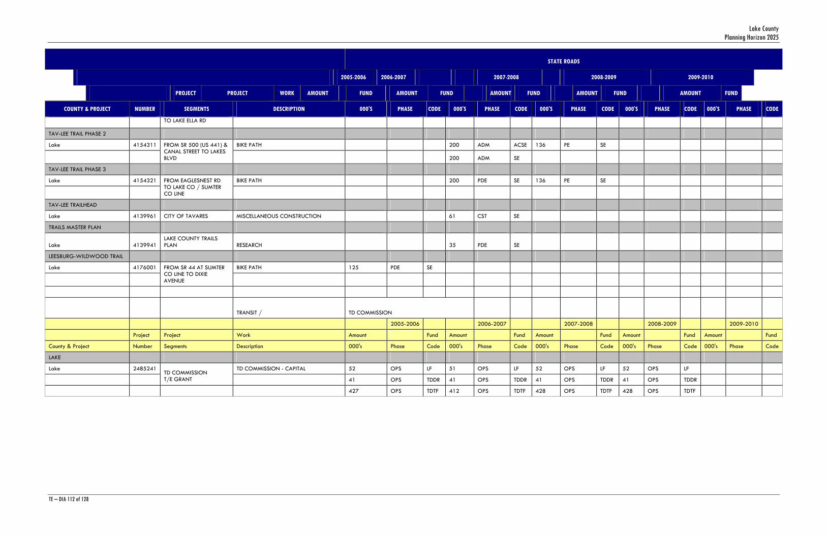
Lake County Planning Horizon 2025
TE – DIA 112 of 128
STATE ROADS
2005-2006 2006-2007 2007-2008 2008-2009 2009-2010
PROJECT PROJECT WORK AMOUNT FUND AMOUNT FUND AMOUNT FUND AMOUNT FUND AMOUNT FUND
COUNTY & PROJECT NUMBER SEGMENTS DESCRIPTION 000'S PHASE CODE 000'S PHASE CODE 000'S PHASE CODE 000'S PHASE CODE 000'S PHASE CODE
TO LAKE ELLA RD
TAV-LEE TRAIL PHASE 2
Lake 4154311 BIKE PATH 200 ADM ACSE 136 PE SE
FROM SR 500 (US 441) & CANAL STREET TO LAKES BLVD 200 ADM SE
TAV-LEE TRAIL PHASE 3
Lake 4154321 BIKE PATH 200 PDE SE 136 PE SE
FROM EAGLESNEST RD TO LAKE CO / SUMTER CO LINE
TAV-LEE TRAILHEAD
Lake 4139961 CITY OF TAVARES MISCELLANEOUS CONSTRUCTION 61 CST SE
TRAILS MASTER PLAN
Lake 4139941 LAKE COUNTY TRAILS PLAN RESEARCH 35 PDE SE
LEESBURG-WILDWOOD TRAIL
Lake 4176001 BIKE PATH 125 PDE SE
FROM SR 44 AT SUMTER CO LINE TO DIXIE AVENUE
TRANSIT / TD COMMISSION
2005-2006 2006-2007 2007-2008 2008-2009 2009-2010
Project Project Work Amount Fund Amount Fund Amount Fund Amount Fund Amount Fund
County & Project Number Segments Description 000's Phase Code 000's Phase Code 000's Phase Code 000's Phase Code 000's Phase Code
LAKE
Lake 2485241 TD COMMISSION - CAPITAL 52 OPS LF 51 OPS LF 52 OPS LF 52 OPS LF
TD COMMISSION T/E GRANT 41 OPS TDDR 41 OPS TDDR 41 OPS TDDR 41 OPS TDDR
427 OPS TDTF 412 OPS TDTF 428 OPS TDTF 428 OPS TDTF
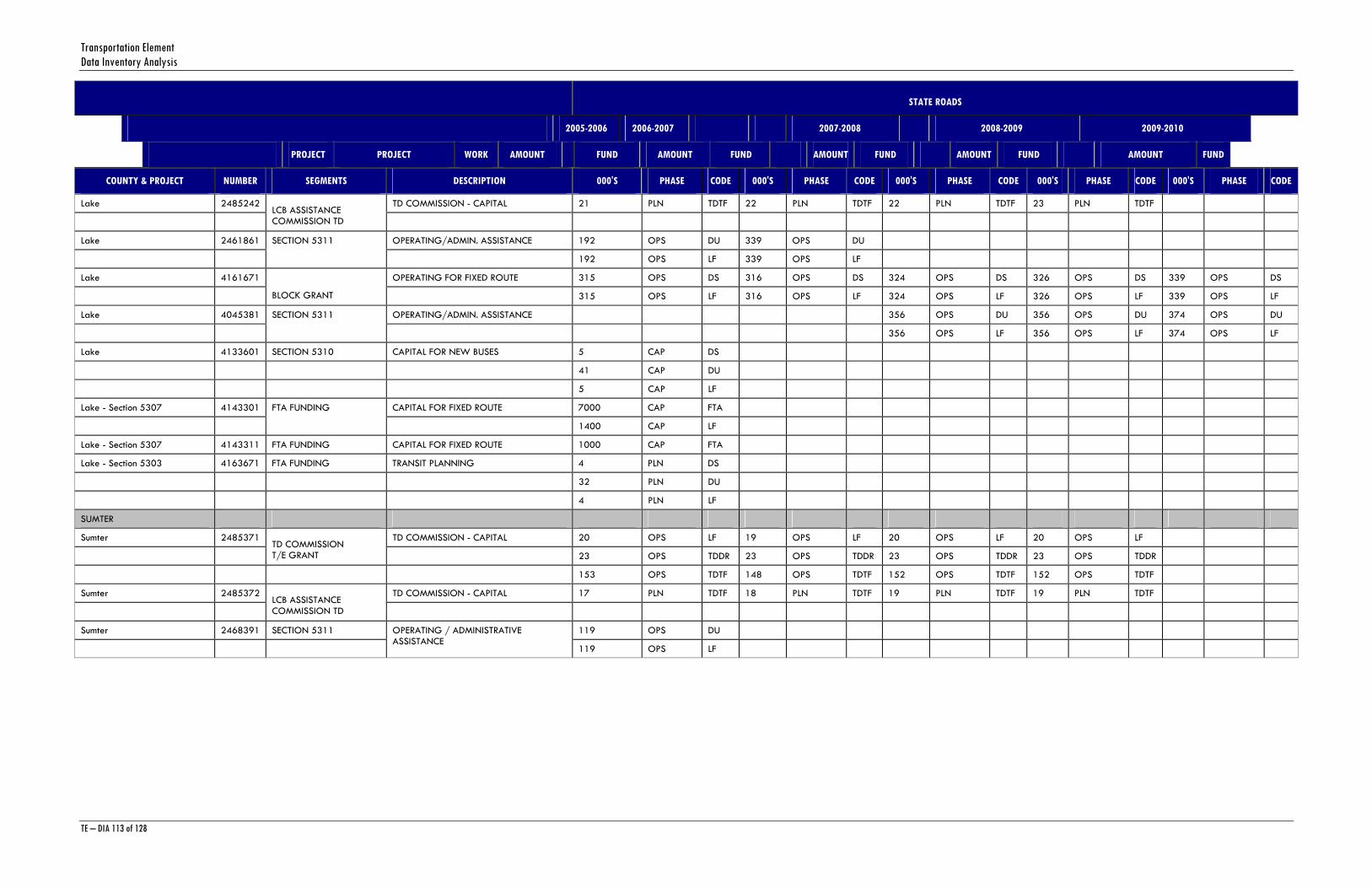
Transportation Element Data Inventory Analysis
TE – DIA 113 of 128
STATE ROADS
2005-2006 2006-2007 2007-2008 2008-2009 2009-2010
PROJECT PROJECT WORK AMOUNT FUND AMOUNT FUND AMOUNT FUND AMOUNT FUND AMOUNT FUND
COUNTY & PROJECT NUMBER SEGMENTS DESCRIPTION 000'S PHASE CODE 000'S PHASE CODE 000'S PHASE CODE 000'S PHASE CODE 000'S PHASE CODE
Lake 2485242 TD COMMISSION - CAPITAL 21 PLN TDTF 22 PLN TDTF 22 PLN TDTF 23 PLN TDTF
LCB ASSISTANCE COMMISSION TD
Lake 2461861 OPERATING/ADMIN. ASSISTANCE 192 OPS DU 339 OPS DU
SECTION 5311
192 OPS LF 339 OPS LF
Lake 4161671 OPERATING FOR FIXED ROUTE 315 OPS DS 316 OPS DS 324 OPS DS 326 OPS DS 339 OPS DS
BLOCK GRANT 315 OPS LF 316 OPS LF 324 OPS LF 326 OPS LF 339 OPS LF
Lake 4045381 OPERATING/ADMIN. ASSISTANCE 356 OPS DU 356 OPS DU 374 OPS DU
SECTION 5311
356 OPS LF 356 OPS LF 374 OPS LF
Lake 4133601 SECTION 5310 CAPITAL FOR NEW BUSES 5 CAP DS
41 CAP DU
5 CAP LF
Lake - Section 5307 4143301 CAPITAL FOR FIXED ROUTE 7000 CAP FTA
FTA FUNDING
1400 CAP LF
Lake - Section 5307 4143311 FTA FUNDING CAPITAL FOR FIXED ROUTE 1000 CAP FTA
Lake - Section 5303 4163671 FTA FUNDING TRANSIT PLANNING 4 PLN DS
32 PLN DU
4 PLN LF
SUMTER
Sumter 2485371 TD COMMISSION - CAPITAL 20 OPS LF 19 OPS LF 20 OPS LF 20 OPS LF
TD COMMISSION T/E GRANT 23 OPS TDDR 23 OPS TDDR 23 OPS TDDR 23 OPS TDDR
153 OPS TDTF 148 OPS TDTF 152 OPS TDTF 152 OPS TDTF
Sumter 2485372 TD COMMISSION - CAPITAL 17 PLN TDTF 18 PLN TDTF 19 PLN TDTF 19 PLN TDTF
LCB ASSISTANCE COMMISSION TD
Sumter 2468391 SECTION 5311 119 OPS DU
OPERATING / ADMINISTRATIVE ASSISTANCE
119 OPS LF
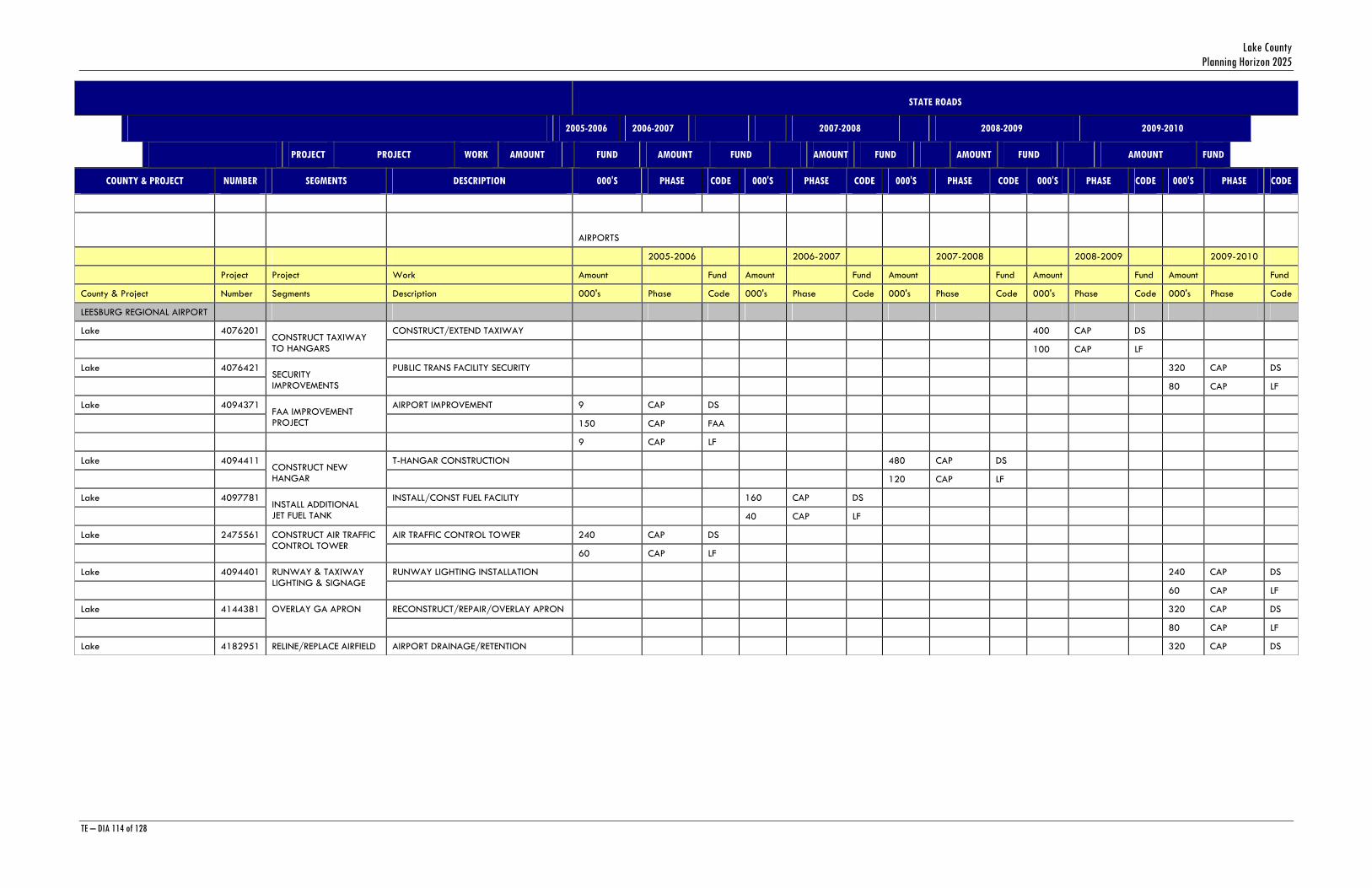
Lake County Planning Horizon 2025
TE – DIA 114 of 128
STATE ROADS
2005-2006 2006-2007 2007-2008 2008-2009 2009-2010
PROJECT PROJECT WORK AMOUNT FUND AMOUNT FUND AMOUNT FUND AMOUNT FUND AMOUNT FUND
COUNTY & PROJECT NUMBER SEGMENTS DESCRIPTION 000'S PHASE CODE 000'S PHASE CODE 000'S PHASE CODE 000'S PHASE CODE 000'S PHASE CODE
AIRPORTS
2005-2006 2006-2007 2007-2008 2008-2009 2009-2010
Project Project Work Amount Fund Amount Fund Amount Fund Amount Fund Amount Fund
County & Project Number Segments Description 000's Phase Code 000's Phase Code 000's Phase Code 000's Phase Code 000's Phase Code
LEESBURG REGIONAL AIRPORT
Lake 4076201 CONSTRUCT/EXTEND TAXIWAY 400 CAP DS
CONSTRUCT TAXIWAY TO HANGARS 100 CAP LF
Lake 4076421 PUBLIC TRANS FACILITY SECURITY 320 CAP DS
SECURITY IMPROVEMENTS 80 CAP LF
Lake 4094371 AIRPORT IMPROVEMENT 9 CAP DS
FAA IMPROVEMENT PROJECT 150 CAP FAA
9 CAP LF
Lake 4094411 T-HANGAR CONSTRUCTION 480 CAP DS
CONSTRUCT NEW HANGAR 120 CAP LF
Lake 4097781 INSTALL/CONST FUEL FACILITY 160 CAP DS
INSTALL ADDITIONAL JET FUEL TANK 40 CAP LF
Lake 2475561 AIR TRAFFIC CONTROL TOWER 240 CAP DS
CONSTRUCT AIR TRAFFIC CONTROL TOWER
60 CAP LF
Lake 4094401 RUNWAY LIGHTING INSTALLATION 240 CAP DS
RUNWAY & TAXIWAY LIGHTING & SIGNAGE
60 CAP LF
Lake 4144381 RECONSTRUCT/REPAIR/OVERLAY APRON 320 CAP DS
OVERLAY GA APRON
80 CAP LF
Lake 4182951 RELINE/REPLACE AIRFIELD AIRPORT DRAINAGE/RETENTION 320 CAP DS
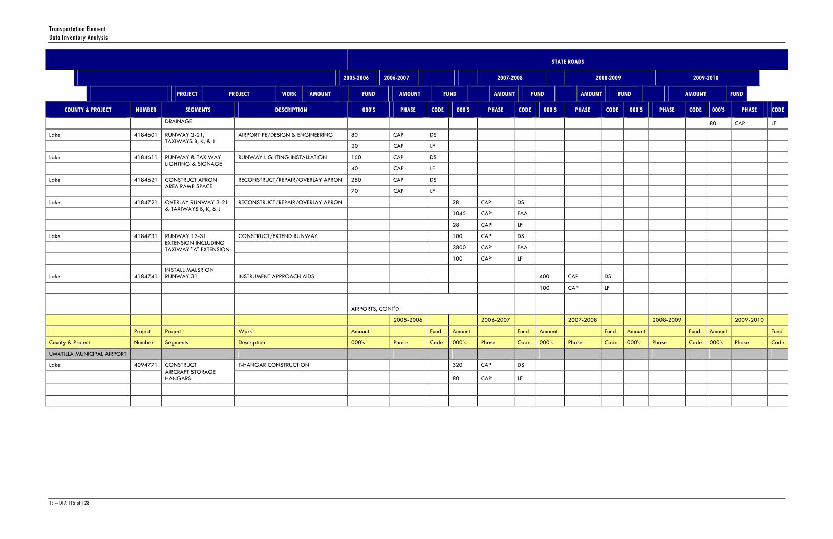
Transportation Element Data Inventory Analysis
TE – DIA 115 of 128
STATE ROADS
2005-2006 2006-2007 2007-2008 2008-2009 2009-2010
PROJECT PROJECT WORK AMOUNT FUND AMOUNT FUND AMOUNT FUND AMOUNT FUND AMOUNT FUND
COUNTY & PROJECT NUMBER SEGMENTS DESCRIPTION 000'S PHASE CODE 000'S PHASE CODE 000'S PHASE CODE 000'S PHASE CODE 000'S PHASE CODE
DRAINAGE 80 CAP LF
Lake 4184601 AIRPORT PE/DESIGN & ENGINEERING 80 CAP DS
RUNWAY 3-21, TAXIWAYS B, K, & J
20 CAP LF
Lake 4184611 RUNWAY LIGHTING INSTALLATION 160 CAP DS
RUNWAY & TAXIWAY LIGHTING & SIGNAGE
40 CAP LF
Lake 4184621 RECONSTRUCT/REPAIR/OVERLAY APRON 280 CAP DS
CONSTRUCT APRON AREA RAMP SPACE
70 CAP LF
Lake 4184721 RECONSTRUCT/REPAIR/OVERLAY APRON 28 CAP DS
OVERLAY RUNWAY 3-21 & TAXIWAYS B, K, & J
1045 CAP FAA
28 CAP LF
Lake 4184731 CONSTRUCT/EXTEND RUNWAY 100 CAP DS
3800 CAP FAA
RUNWAY 13-31 EXTENSION INCLUDING TAXIWAY "A" EXTENSION
100 CAP LF
Lake 4184741 INSTALL MALSR ON RUNWAY 31 INSTRUMENT APPROACH AIDS 400 CAP DS
100 CAP LF
AIRPORTS, CONT'D
2005-2006 2006-2007 2007-2008 2008-2009 2009-2010
Project Project Work Amount Fund Amount Fund Amount Fund Amount Fund Amount Fund
County & Project Number Segments Description 000's Phase Code 000's Phase Code 000's Phase Code 000's Phase Code 000's Phase Code
UMATILLA MUNICIPAL AIRPORT
Lake 4094771 T-HANGAR CONSTRUCTION 320 CAP DS
CONSTRUCT AIRCRAFT STORAGE HANGARS 80 CAP LF
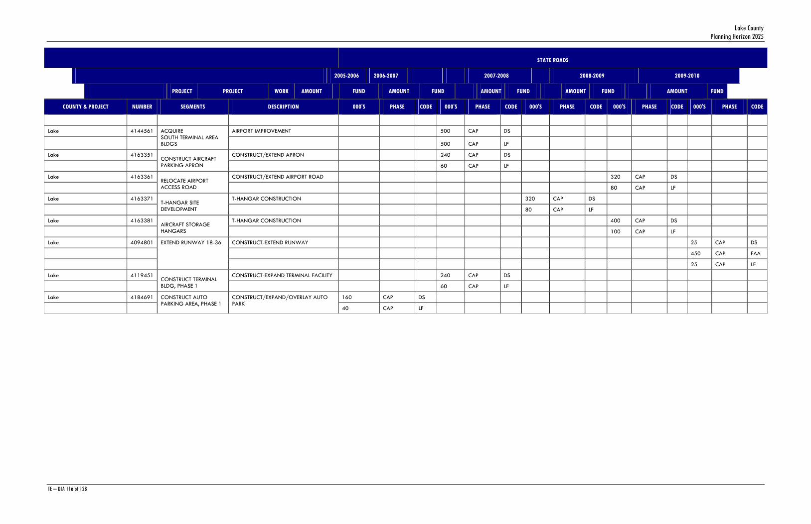
Lake County Planning Horizon 2025
TE – DIA 116 of 128
STATE ROADS
2005-2006 2006-2007 2007-2008 2008-2009 2009-2010
PROJECT PROJECT WORK AMOUNT FUND AMOUNT FUND AMOUNT FUND AMOUNT FUND AMOUNT FUND
COUNTY & PROJECT NUMBER SEGMENTS DESCRIPTION 000'S PHASE CODE 000'S PHASE CODE 000'S PHASE CODE 000'S PHASE CODE 000'S PHASE CODE
Lake 4144561 AIRPORT IMPROVEMENT 500 CAP DS
ACQUIRE SOUTH TERMINAL AREA BLDGS 500 CAP LF
Lake 4163351 CONSTRUCT/EXTEND APRON 240 CAP DS
CONSTRUCT AIRCRAFT PARKING APRON 60 CAP LF
Lake 4163361 CONSTRUCT/EXTEND AIRPORT ROAD 320 CAP DS
RELOCATE AIRPORT ACCESS ROAD 80 CAP LF
Lake 4163371 T-HANGAR CONSTRUCTION 320 CAP DS
T-HANGAR SITE DEVELOPMENT 80 CAP LF
Lake 4163381 T-HANGAR CONSTRUCTION 400 CAP DS
AIRCRAFT STORAGE HANGARS 100 CAP LF
Lake 4094801 CONSTRUCT-EXTEND RUNWAY 25 CAP DS
450 CAP FAA
EXTEND RUNWAY 18-36
25 CAP LF
Lake 4119451 CONSTRUCT-EXPAND TERMINAL FACILITY 240 CAP DS
CONSTRUCT TERMINAL BLDG, PHASE 1 60 CAP LF
Lake 4184691 160 CAP DS
CONSTRUCT AUTO PARKING AREA, PHASE 1
CONSTRUCT/EXPAND/OVERLAY AUTO PARK
40 CAP LF
Transportation Element Data Inventory Analysis
TE – DIA 117 of 128
APPENDIX C 2005 Lake County Traffic Counts
Source: Lake County Public Works

Lake County Planning Horizon 2025
TE – DIA 118 of 128

Transportation Element Data Inventory Analysis
TE – DIA 119 of 128
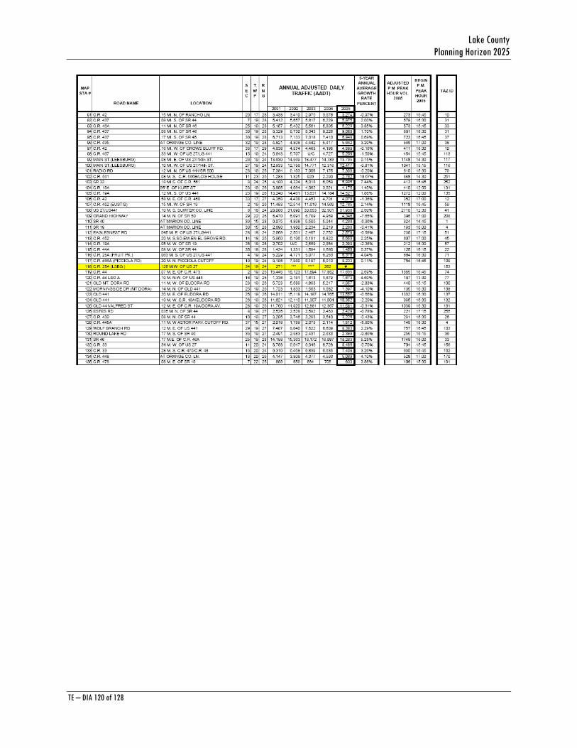
Lake County Planning Horizon 2025
TE – DIA 120 of 128
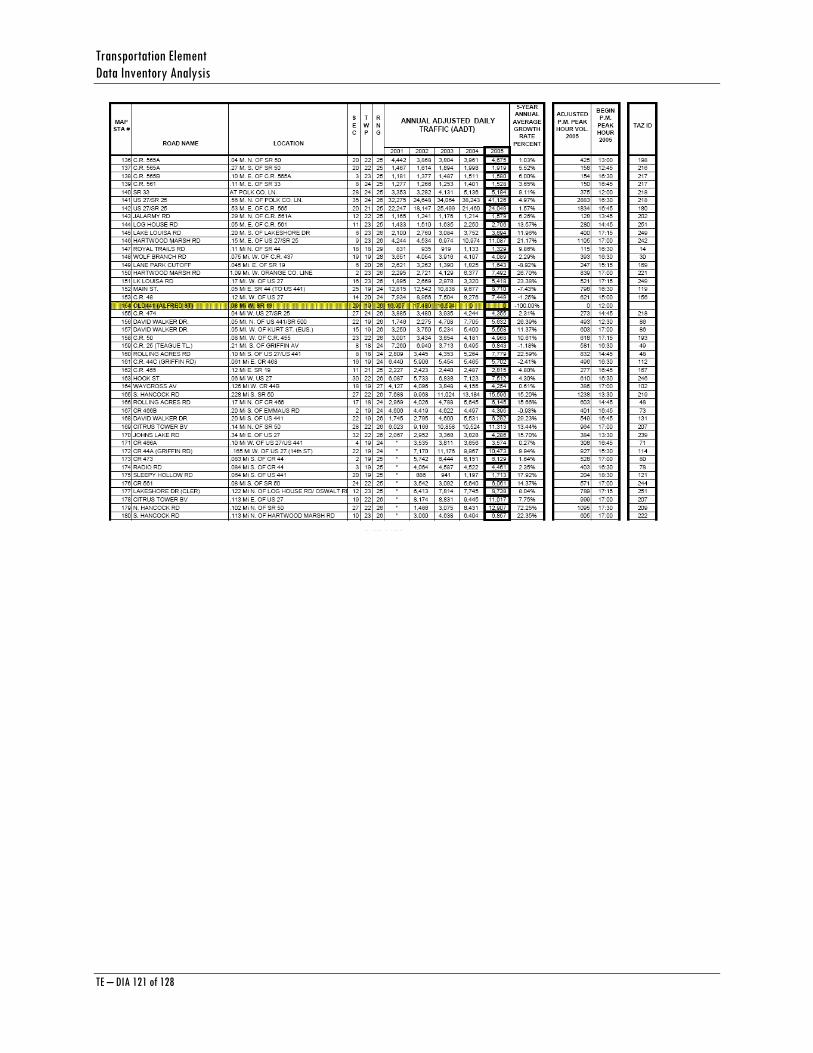
Transportation Element Data Inventory Analysis
TE – DIA 121 of 128
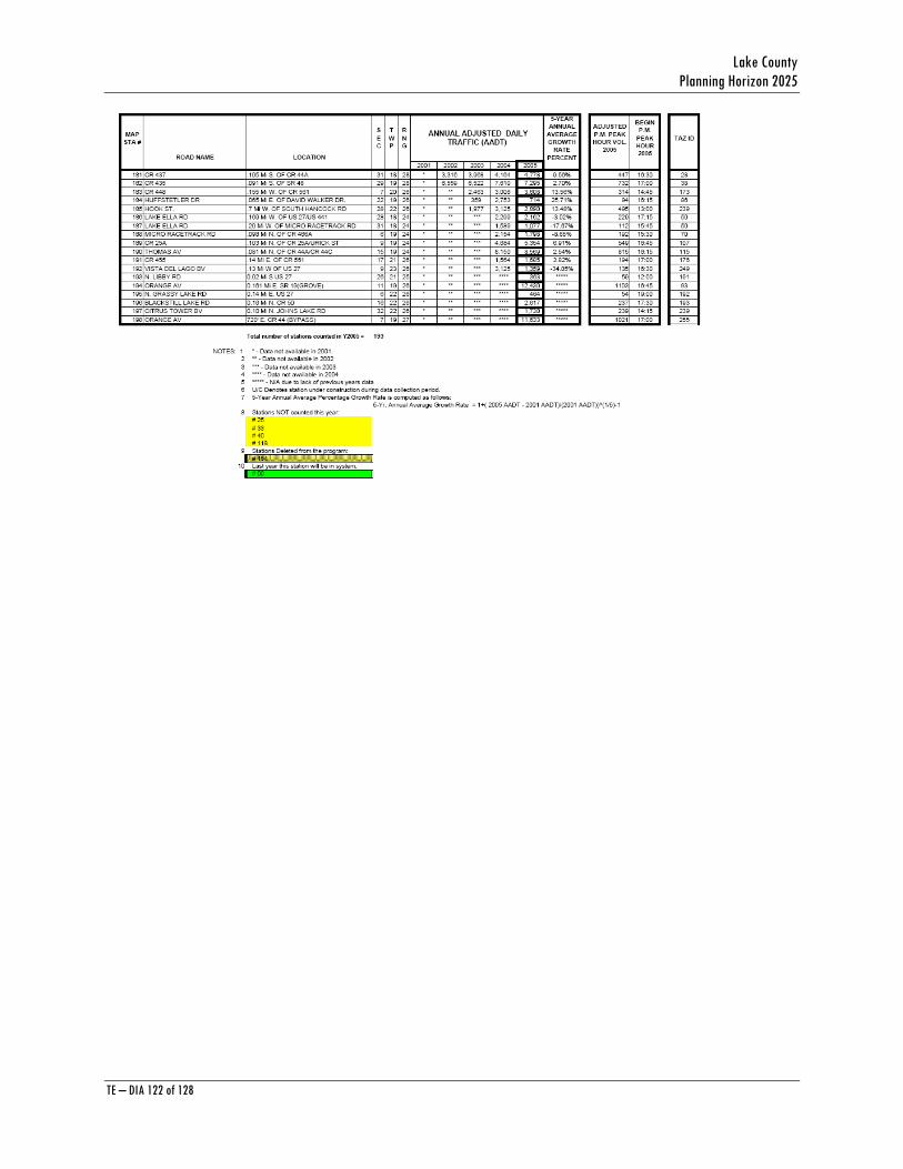
Lake County Planning Horizon 2025
TE – DIA 122 of 128
Transportation Element Data Inventory Analysis
TE – DIA 123 of 128
APPENDIX D 2010 to 2015 Costs and 2016 to 2025 Costs
Source: Lake-Sumter Metropolitan Planning Organization (MPO) Long Range Transportation Plan
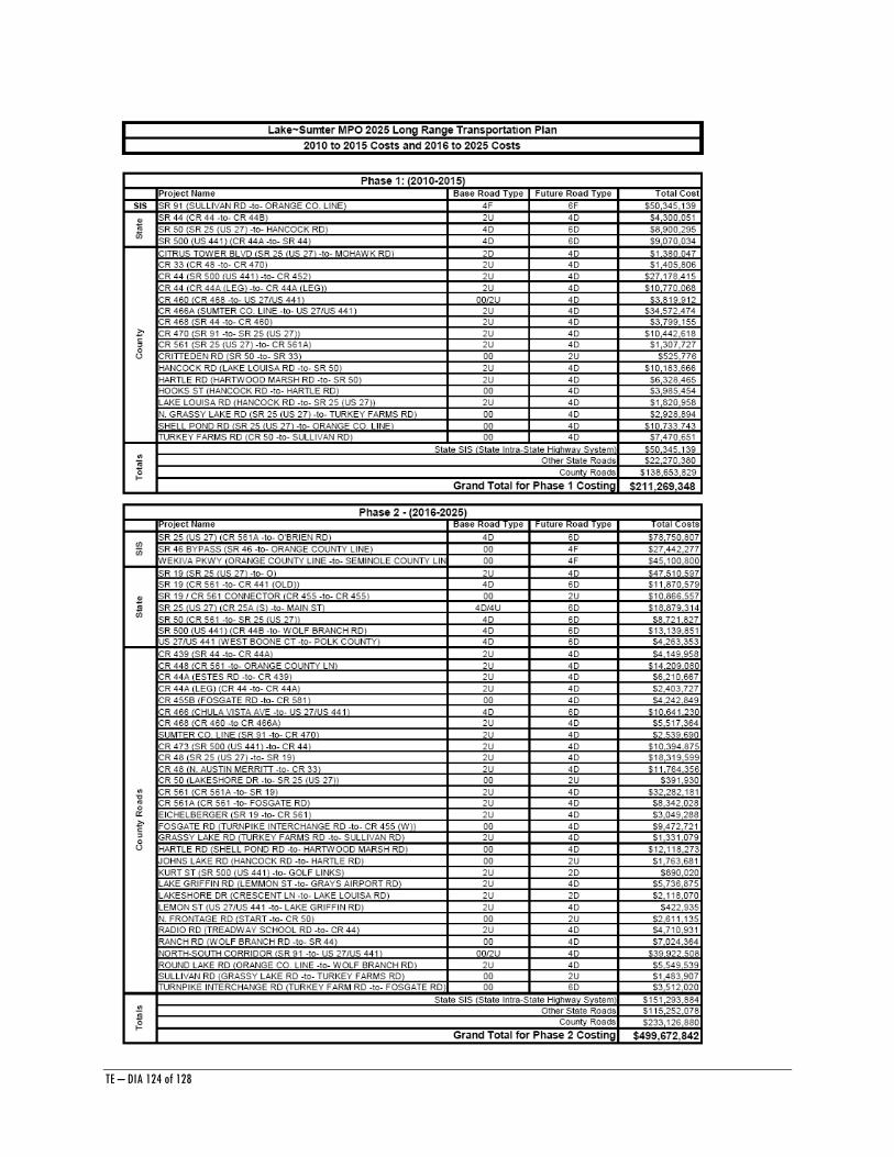
TE – DIA 124 of 128