9 THE BORNEO EAST-WEST SEA CROSSINGS BETWEEN … · Pontianak port is overwhelmingly large compared...
165
The Master Plan and Feasibility Study on the Establishment of an ASEAN RO-RO Shipping Network and Short Sea Shipping FINAL REPORT: Volume 1 9-1 9 THE BORNEO EAST-WEST SEA CROSSINGS BETWEEN INDONESIA AND MALAYSIA This chapter reports the results of the field survey encompassing two Borneo connected routes. They are (i) the Johor – Sintete route, and (ii) the Tawau – Tarakan – Pantoloan route. Figure 9.1 Location of Surveyed Routes 9.1 Economy and Trade 1) Johor, Malaysia Johor, the southernmost state of Peninsular Malaysia, has a long coastline flanking the Straits of Malacca on its western seaboard and the South China Sea on the east. Known as the "Southern Gateway", Johor is the second largest state (at 19,984 km 2 ) and is also one of the most developed in Peninsular Malaysia. Johor's capital city, Johor Bahru (or “JB” as it is popularly known), is the main administrative center for the state government and a bustling commercial hub. This southernmost Malaysian city sits right next to the national boundary between Malaysia and Singapore where they are connected via the Johor Causeway. Thirty kilometers southwest of Johor Bahru is the Second Link which connects Tanjung Kupang to Tuas in Singapore. Located within the district are the Sultan Ismail International Airport, Johor Causeway, Second Link and the Johor Bahru International Ferry Terminal. Johor's population increased from 3.2 million in 2008 to 3.35 million in 2010 (see Table 9.1). After experiencing a negative 4% growth in 2009, its GRDP at current price recovered in 2010, to MYR20.9 billion. The Per Capita GRDP that year was USD6,499. The services and manufacturing sectors are the main drivers of Johor's economy, contributing 50% and 34%, respectively, to GRDP. The agriculture sector has an 11% share.
Transcript of 9 THE BORNEO EAST-WEST SEA CROSSINGS BETWEEN … · Pontianak port is overwhelmingly large compared...

The Master Plan and Feasibility Study on the Establishment of an ASEAN RO-RO Shipping Network and Short Sea Shipping FINAL REPORT: Volume 1
9-1
9 THE BORNEO EAST-WEST SEA CROSSINGS BETWEEN INDONESIA AND MALAYSIA This chapter reports the results of the field survey encompassing two Borneo connected routes. They are (i) the Johor – Sintete route, and (ii) the Tawau – Tarakan – Pantoloan route.
Figure 9.1 Location of Surveyed Routes
9.1 Economy and Trade 1) Johor, Malaysia
Johor, the southernmost state of Peninsular Malaysia, has a long coastline flanking the Straits of Malacca on its western seaboard and the South China Sea on the east.
Known as the "Southern Gateway", Johor is the second largest state (at 19,984 km2) and is also one of the most developed in Peninsular Malaysia. Johor's capital city, Johor Bahru (or “JB” as it is popularly known), is the main administrative center for the state government and a bustling commercial hub. This southernmost Malaysian city sits right next to the national boundary between Malaysia and Singapore where they are connected via the Johor Causeway. Thirty kilometers southwest of Johor Bahru is the Second Link which connects Tanjung Kupang to Tuas in Singapore. Located within the district are the Sultan Ismail International Airport, Johor Causeway, Second Link and the Johor Bahru International Ferry Terminal.
Johor's population increased from 3.2 million in 2008 to 3.35 million in 2010 (see Table 9.1). After experiencing a negative 4% growth in 2009, its GRDP at current price recovered in 2010, to MYR20.9 billion. The Per Capita GRDP that year was USD6,499. The services and manufacturing sectors are the main drivers of Johor's economy, contributing 50% and 34%, respectively, to GRDP. The agriculture sector has an 11% share.

The Master Plan and Feasibility Study on the Establishment of an ASEAN RO-RO Shipping Network and Short Sea Shipping FINAL REPORT: Volume 1
9-2
Table 9.1 Socioeconomic Indicators of Johor State, 2008-2010
Year Population (Million)
GRDP at Current Prices
(MYR Million)
Per Capita GRDP at Current Prices
(USD) 2008 3.20 20,045 nd 2009 3.30 18,656 nd 2010 3.35 20,911 6,499
Source: Department of Statistics, Malaysia
The State's major agricultural products are crude palm oil, fruits and vegetables, rubber, fresh and canned pineapple, and coconut. It also produces livestock and various fishery products (e.g., prawns, freshwater and aquarium fish), rocks and minerals, and timber products.
The total volume of exports/ imports at the Johor Port does not change much yearly. The average daily volume is about 80,000 MT (see Figure 9.2). Palm oil is a major loaded good, and petroleum, fertilizer and cement are major unloaded goods (see Figure 9.3).
Source: All Ports and Marine Department, Malaysia
Figure 9.2 Average Daily Cargo Volume at Johor Port, 2001-2010 (in 000 MT)
Loaded Cargo Unloaded Cargo
Source: All Ports and Marine Department, Malaysia
Figure 9.3 Major Commodities at Johor Port, 2010 (by Weight)
Although the number of domestic air passengers coming to Johor Bahru was 1.2 million in 2010, the number of international passengers is very small. Most of the international
0102030405060708090
2001 2002 2003 2004 2005 2006 2007 2008 2009 2010
Export Import
Others53.7%
Palm Oil29.8%
PalmKernelWaste3.6%
Petroleum and
Fuel Oil9.5%Chemical/
Fertilizer2.7%
Iron/ Steel0.7%
Palm Oil8.7%
Cement/Clinker9.1%
Others44.9%
Chemical/Fertilizer14.0%
Grains/Cereal3.9%
Iron/ Steel2.8%
Petroleum and
Fuel Oil16.6%
The Master Plan and Feasibility Study on the Establishment of an ASEAN RO-RO Shipping Network and Short Sea Shipping FINAL REPORT: Volume 1
9-3
tourists can go to JB by land transportation from Singapore. Many foreign visitors visiting JB are Singaporeans because of the close distance between Singapore and JB. Malaysia is also a very popular destination for Indonesians.
The Johor Port Authority (JPA) regulates the operations of ports in four locations, namely (1) the Johor Port at Pasir Gudang, (2) the Tanjung Pelepas Port at Gelang Patah, (3) the Tanjung Belungkor Ferry Terminal at Kota Tinggi, and (4) the Changi Ferry Terminal in Singapore. For the ASEAN RO-RO project, JPA designated the Tanjung Belungkor Ferry Terminal (TBFT) to be connected with Sintete, West Kalimantan, Indonesia.
There used to be RO-RO service operations at TBFT from 2001-2006. Now, only passenger ferries operate at the port. The active passenger ferry routes served are the Tanjung Belungkor-Changi Terminal route and Tanjung Belungkor-Batam and Tanjung Pinang routes. There is currently only one ferry operator providing ferry service between CFT and TBFT – a Malaysian company called Limbongan Maju Sdn. Bhd. Limbongan Maju is chartering a vessel from Indo Falcon Travel & Shipping Pte. Ltd., MV Falcon II, which can take maximum 126 passengers. The average load factor per trip is about 24% (based on average 30 passengers per trip from information obtained between the months of May – July 2012, when Limbongan Maju first started operations. There was no ferry service between CFT-TBFT from Jan to mid April). There are 2 and 4 round trips from Tanjung Belukor to Singapore on weekdays and weekends respectively. TBFT is dedicated to passenger services operation. It cannot operate cargo services except for hand-carried cargo limited to 10 kg per passenger.
2) Sintete, West Kalimantan, Indonesia
The characters of the east side and west side of Borneo are quite different because the east of Kalimantan in Indonesia has oil resources and is comparatively a rich region while the west of Kalimantan depends mainly on agricultural products. However, both ports in Indonesia need daily consumer products from Malaysia by the export of agricultural products.
Sintete Port is located in Sambas Regency, one of the regencies of West Kalimantan province in Indonesia. Sambas is located in the northern part of the province, bounded in the north by Sarawak, Malaysia and Natuna Sea, in the south by Bengkayang Regency and Singkawang City, in the west by Natuna Sea, and in the east by Sarawak and Bengkayang Regency. Sintete is about 200 km north of Pontianak. Its population in 2010 was about 4.4 million (see Table 9.2). Around 11% of the provincial population live in Sambas Regency.
Table 9.2 Socioeconomic Indicators of West Kalimantan, 2000-2009
Year Province/ Regency Population
GRDP at Current Prices
(IDR Billion)
Per Capita GRDP at Current Prices
(USD)b
2000 West Kalimantan 4,016,353 19,319 511 Sambas 454,126 nd nd
2005 West Kalimantan 4,042,817 33,869 850 Sambas 476,036a 3,265 696
2010 West Kalimantan 4,393,239 53,866 1,375 Sambas 496,116 5,903 1,334
Notes: a-2003 population of Sambas; b-per capita GRDPs computed at prevailing dollar-rupiah exchange rates during respective years.
Source: Statistics of West Kalimantan
The Master Plan and Feasibility Study on the Establishment of an ASEAN RO-RO Shipping Network and Short Sea Shipping FINAL REPORT: Volume 1
9-4
West Kalimantan's economy has been growing at a substantial average rate of 14% a year in the last 10 years. Its GRDP at current prices in 2010 was IDR53.9 trillion, resulting in a Per Capita GRDP of USD1,375. Its economy was dominated by the agricultural sector (26%), trading sector (24%), and processing sector (17%). Its major products include pepper, cocoa, coconut, oil palm, rubber, cloves, coffee, and marine and cultured fish. Its tourism sector focuses on nature- and culture-based tourism. In 2009, over 20,000 visitors mostly from ASEAN countries visited the province. To support its economic activities, there are seven (7) airports and six (6) sea ports in the province.
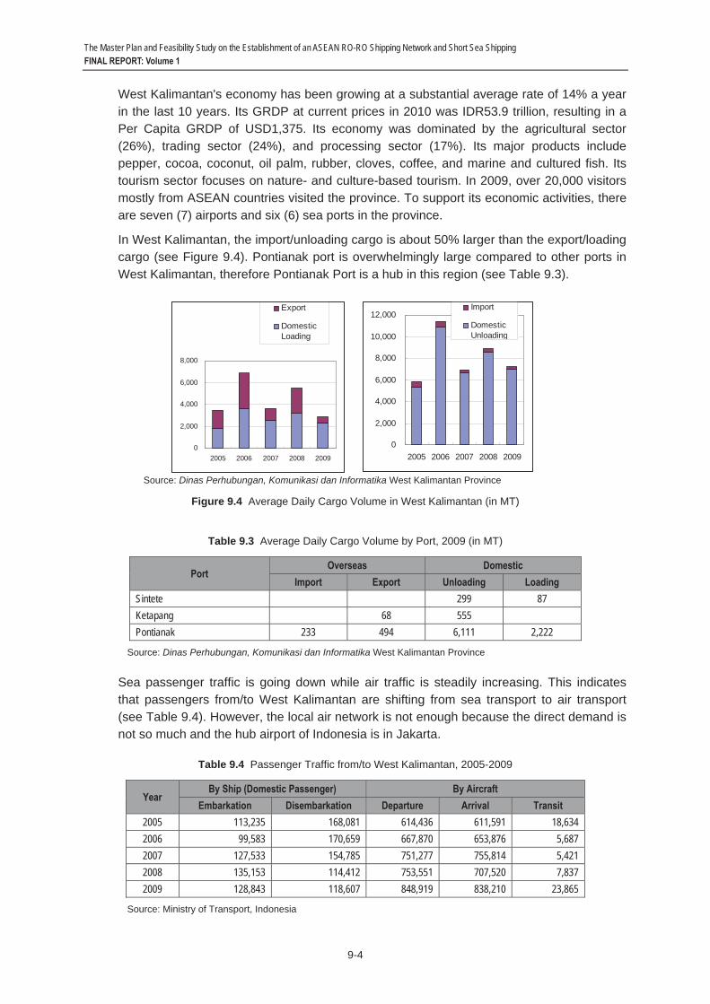
In West Kalimantan, the import/unloading cargo is about 50% larger than the export/loading cargo (see Figure 9.4). Pontianak port is overwhelmingly large compared to other ports in West Kalimantan, therefore Pontianak Port is a hub in this region (see Table 9.3).
Source: Dinas Perhubungan, Komunikasi dan Informatika West Kalimantan Province
Figure 9.4 Average Daily Cargo Volume in West Kalimantan (in MT)
Table 9.3 Average Daily Cargo Volume by Port, 2009 (in MT)
Port Overseas Domestic
Import Export Unloading Loading Sintete 299 87 Ketapang 68 555 Pontianak 233 494 6,111 2,222
Source: Dinas Perhubungan, Komunikasi dan Informatika West Kalimantan Province
Sea passenger traffic is going down while air traffic is steadily increasing. This indicates that passengers from/to West Kalimantan are shifting from sea transport to air transport (see Table 9.4). However, the local air network is not enough because the direct demand is not so much and the hub airport of Indonesia is in Jakarta.
Table 9.4 Passenger Traffic from/to West Kalimantan, 2005-2009
Year By Ship (Domestic Passenger) By Aircraft
Embarkation Disembarkation Departure Arrival Transit 2005 113,235 168,081 614,436 611,591 18,634 2006 99,583 170,659 667,870 653,876 5,687 2007 127,533 154,785 751,277 755,814 5,421 2008 135,153 114,412 753,551 707,520 7,837 2009 128,843 118,607 848,919 838,210 23,865
Source: Ministry of Transport, Indonesia
0
2,000
4,000
6,000
8,000
2005 2006 2007 2008 2009
Export
DomesticLoading
0
2,000
4,000
6,000
8,000
10,000
12,000
2005 2006 2007 2008 2009
Import
DomesticUnloading
The Master Plan and Feasibility Study on the Establishment of an ASEAN RO-RO Shipping Network and Short Sea Shipping FINAL REPORT: Volume 1
9-5
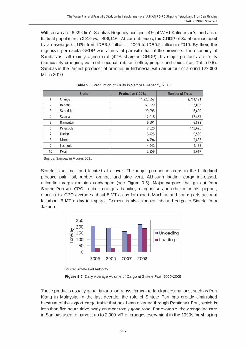
With an area of 6,396 km2, Sambas Regency occupies 4% of West Kalimantan's land area. Its total population in 2010 was 496,116. At current prices, the GRDP of Sambas increased by an average of 16% from IDR3.3 trillion in 2005 to IDR5.9 trillion in 2010. By then, the regency's per capita GRDP was almost at par with that of the province. The economy of Sambas is still mainly agricultural (42% share in GRDP). Its major products are fruits (particularly oranges), palm oil, coconut, rubber, coffee, pepper and cocoa (see Table 9.5). Sambas is the largest producer of oranges in Indonesia, with an output of around 122,000 MT in 2010.
Table 9.5 Production of Fruits in Sambas Regency, 2010
Fruits Production (100 kg) Number of Trees 1 Orange 1,222,553 2,701,131 2 Banana 51,929 113,003 3 Sapodilla 29,995 16,699 4 Salacia 12,018 63,487 5 Rambutan 9,901 6,588 6 Pineapple 7,620 113,625 7 Durian 5,425 9,559 8 Mango 4,794 2,833 9 Jackfruit 4,242 4,136 10 Petai 2,959 9,617
Source: Sambas in Figures 2011
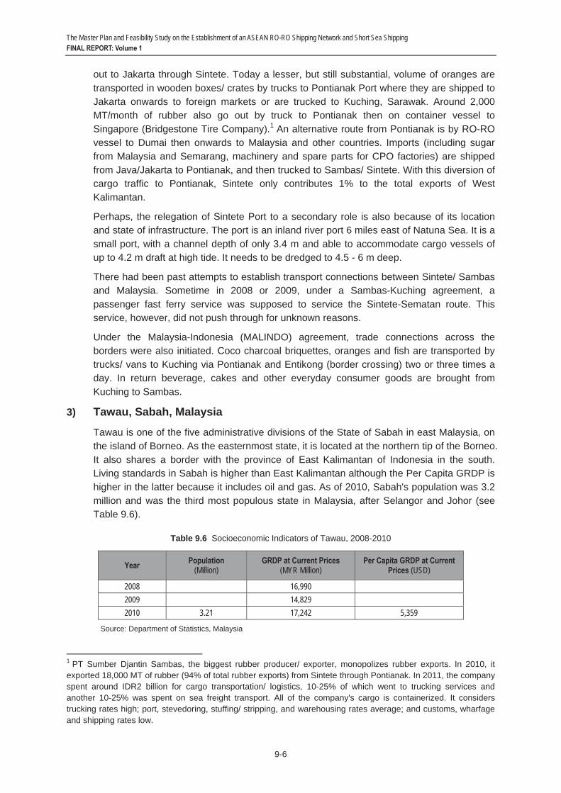
Sintete is a small port located at a river. The major production areas in the hinterland produce palm oil, rubber, orange, and aloe vera. Although loading cargo increased, unloading cargo remains unchanged (see Figure 9.5). Major cargoes that go out from Sintete Port are CPO, rubber, oranges, bauxite, manganese and other minerals, pepper, other fruits. CPO averages about 8 MT a day for export. Machine and spare parts account for about 6 MT a day in imports. Cement is also a major inbound cargo to Sintete from Jakarta.
Source: Sintete Port Authority
Figure 9.5 Daily Average Volume of Cargo at Sintete Port, 2005-2008
These products usually go to Jakarta for transshipment to foreign destinations, such as Port Klang in Malaysia. In the last decade, the role of Sintete Port has greatly diminished because of the export cargo traffic that has been diverted through Pontianak Port, which is less than five hours drive away on moderately good road. For example, the orange industry in Sambas used to harvest up to 2,000 MT of oranges every night in the 1990s for shipping
050
100150200250
2005 2006 2007 2008
Ton/
day
UnloadingLoading
The Master Plan and Feasibility Study on the Establishment of an ASEAN RO-RO Shipping Network and Short Sea Shipping FINAL REPORT: Volume 1
9-6
out to Jakarta through Sintete. Today a lesser, but still substantial, volume of oranges are transported in wooden boxes/ crates by trucks to Pontianak Port where they are shipped to Jakarta onwards to foreign markets or are trucked to Kuching, Sarawak. Around 2,000 MT/month of rubber also go out by truck to Pontianak then on container vessel to Singapore (Bridgestone Tire Company).1 An alternative route from Pontianak is by RO-RO vessel to Dumai then onwards to Malaysia and other countries. Imports (including sugar from Malaysia and Semarang, machinery and spare parts for CPO factories) are shipped from Java/Jakarta to Pontianak, and then trucked to Sambas/ Sintete. With this diversion of cargo traffic to Pontianak, Sintete only contributes 1% to the total exports of West Kalimantan.
Perhaps, the relegation of Sintete Port to a secondary role is also because of its location and state of infrastructure. The port is an inland river port 6 miles east of Natuna Sea. It is a small port, with a channel depth of only 3.4 m and able to accommodate cargo vessels of up to 4.2 m draft at high tide. It needs to be dredged to 4.5 - 6 m deep.
There had been past attempts to establish transport connections between Sintete/ Sambas and Malaysia. Sometime in 2008 or 2009, under a Sambas-Kuching agreement, a passenger fast ferry service was supposed to service the Sintete-Sematan route. This service, however, did not push through for unknown reasons.
Under the Malaysia-Indonesia (MALINDO) agreement, trade connections across the borders were also initiated. Coco charcoal briquettes, oranges and fish are transported by trucks/ vans to Kuching via Pontianak and Entikong (border crossing) two or three times a day. In return beverage, cakes and other everyday consumer goods are brought from Kuching to Sambas.
3) Tawau, Sabah, Malaysia
Tawau is one of the five administrative divisions of the State of Sabah in east Malaysia, on the island of Borneo. As the easternmost state, it is located at the northern tip of the Borneo. It also shares a border with the province of East Kalimantan of Indonesia in the south. Living standards in Sabah is higher than East Kalimantan although the Per Capita GRDP is higher in the latter because it includes oil and gas. As of 2010, Sabah's population was 3.2 million and was the third most populous state in Malaysia, after Selangor and Johor (seeTable 9.6).
Table 9.6 Socioeconomic Indicators of Tawau, 2008-2010
Year Population (Million)
GRDP at Current Prices (MYR Million)
Per Capita GRDP at Current Prices (USD)
2008 16,990 2009 14,829 2010 3.21 17,242 5,359
Source: Department of Statistics, Malaysia
1 PT Sumber Djantin Sambas, the biggest rubber producer/ exporter, monopolizes rubber exports. In 2010, it exported 18,000 MT of rubber (94% of total rubber exports) from Sintete through Pontianak. In 2011, the company spent around IDR2 billion for cargo transportation/ logistics, 10-25% of which went to trucking services and another 10-25% was spent on sea freight transport. All of the company's cargo is containerized. It considers trucking rates high; port, stevedoring, stuffing/ stripping, and warehousing rates average; and customs, wharfage and shipping rates low.
The Master Plan and Feasibility Study on the Establishment of an ASEAN RO-RO Shipping Network and Short Sea Shipping FINAL REPORT: Volume 1
9-7
Sabah's economy shrunk by 13% in 2009 mainly from the effects of the global financial crisis that affected its tourism and export industries. It bounced back in 2010 when its GRDP grew by 16% to MYR17.2 billion, translating to a per capita GRDP of USD5,359. Sabah is a globally known premier tourist destination. Tourism, particularly ecotourism, is a major contributor to the economy of Sabah. Tourism is one of the priority sectors under the Halatuju development direction, which also focuses on the agriculture and manufacturing sectors. In 2006, around 2 million tourists visited Sabah, generating tourism receipts of MYR2.9 billion.
The agriculture sector consistently contributes 25% of the state's GRDP. The key priority investment sectors in Sabah are oil palm, cocoa, rubber, forestry-based, food processing, food production (fruits, vegetables, livestock, and dairy products), marine and aquaculture, and petrochemical industries. At 35% of the national output, Sabah is Malaysia's top palm oil producing state. The State Government has set up the Palm Oil Industry Cluster (POIC) in Lahad Datu to further develop oil palm value adding industries (e.g., biodiesel, oil palm biomass products, and fertilizers).
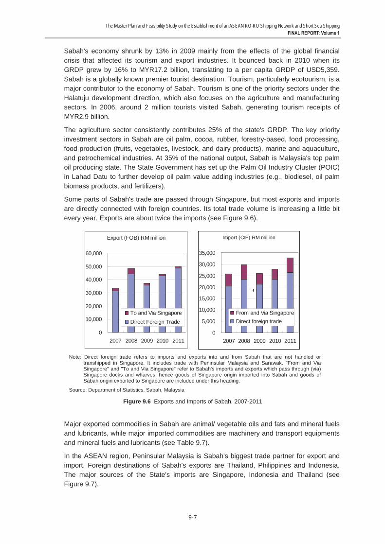
Some parts of Sabah's trade are passed through Singapore, but most exports and imports are directly connected with foreign countries. Its total trade volume is increasing a little bit every year. Exports are about twice the imports (see Figure 9.6).
Note: Direct foreign trade refers to imports and exports into and from Sabah that are not handled or transhipped in Singapore. It includes trade with Peninsular Malaysia and Sarawak. "From and Via Singapore" and "To and Via Singapore" refer to Sabah's imports and exports which pass through (via) Singapore docks and wharves, hence goods of Singapore origin imported into Sabah and goods of Sabah origin exported to Singapore are included under this heading.
Source: Department of Statistics, Sabah, Malaysia
Figure 9.6 Exports and Imports of Sabah, 2007-2011
Major exported commodities in Sabah are animal/ vegetable oils and fats and mineral fuels and lubricants, while major imported commodities are machinery and transport equipments and mineral fuels and lubricants (see Table 9.7).
In the ASEAN region, Peninsular Malaysia is Sabah's biggest trade partner for export and import. Foreign destinations of Sabah's exports are Thailand, Philippines and Indonesia. The major sources of the State's imports are Singapore, Indonesia and Thailand (see Figure 9.7).
Export (FOB) RM million
0
10,000
20,000
30,000
40,000
50,000
60,000
2007 2008 2009 2010 2011
To and Via SingaporeDirect Foreign Trade
Import (CIF) RM million
0
5,000
10,000
15,000
20,000
25,000
30,000
35,000
2007 2008 2009 2010 2011
From and Via SingaporeDirect foreign trade
f

The Master Plan and Feasibility Study on the Establishment of an ASEAN RO-RO Shipping Network and Short Sea Shipping FINAL REPORT: Volume 1
9-8
Table 9.7 Foreign Trade of Sabah, by Commodity, 2011
Commodity Export (MYR 000) Import (MYR 000) Food 1,173,281 3,322,345 Beverages and tobacco 71,918 693,048 Crude materials, inedible 2,064,000 1,072,673 Mineral fuels, lubricants, etc. 17,669,960 6,967,103 Animal/Vegetable oils and fats 22,050,324 862,333 Chemicals 1,674,406 3,662,471 Manufactured goods 3,226,970 4,669,953 Machinery and transport equipment 1,306,907 9,253,679 Miscellaneous manufactured articles 262,184 2,113,966 Miscellaneous transactions and commodities 57,028 167,617
Source: Department of Statistics, Sabah, Malaysia
Source: Department of Statistics, Sabah, Malaysia
Figure 9.7 Trade of Sabah with ASEAN, 2011
Tawau Division occupies a total of 14,905 km2 or 20% of Sabah's territory. Tawau's population in 2009 was 475,000 70% of which are non-Malaysian citizens, including 55,000 Indonesians. Tawau's economy is mainly supported by agriculture, fisheries and aquaculture production. Its main agricultural products are tobacco, cocoa, and palm oil. Malaysia is the world's third largest cocoa producer (next to Ivory Coast and Ghana) because of Tawau, which is also host to vast oil palm plantations. It is also a major fisheries and aquaculture production area, with its high value fishes and tiger prawns being exported to Singapore, Hong Kong, Taiwan and Japan.
Among the significant development projects in Tawau are the Tawau Free Trade Zone; the Kuhara Point, which is an integrated leisure and living complex consisting of a shopping mall, an office tower, a four-star hotel, and high-rise luxurious condominiums; and the Bandar Sri Indah, Sabah's largest (at 5.5 km2) satellite township development project to be constructed on reclaimed land along the Tawau Airport Highway.
Tawau Port is the third largest port in Sabah, after Kota Kinabalu and Sandakan. It has several general cargo/container berths for ships of up to 10,000 DWT and one oil jetty for ships up to 10,000 DWT. The port, which is operated by Sabah Ports Sdn. Bhd. (a
Export to South East Asia (Value)
Malaysia(Peninsula
r)34.4%
Others0.0%
Malaysia(Sarawak)
15.1%
Vietnam4.4%
Thailand19.4%
Singapore4.6%
Philippines11.3%
Indonesia9.1%
Myanmar0.0%
BruneiDarussala
m1.7%
Import from South East Asia (Value)
Malaysia(Peninsula
r)67.8%
Malaysia(Sarawak)
1.5%
Others0.0%
Singapore16.3%
Thailand4.6%
Vietnam1.7%
Myanmar0.0%
Indonesia6.5%
Philippines
1.4%
BruneiDarussala
m0.1%

The Master Plan and Feasibility Study on the Establishment of an ASEAN RO-RO Shipping Network and Short Sea Shipping FINAL REPORT: Volume 1
9-9
government-linked corporation), serves as a major export center for timber, agricultural products (palm oil, crude palm and coconut oil), rubber, and general cargo to various destinations including Kuala Lumpur, Sandakan, Indonesia, Hongkong and Singapore. Imports include fertilizer/ potash from China, Korea, etc., corn from Thailand, and rice from Vietnam, which is transshipped to the Philippines on traditional wooden-hulled boats.
Tawau Port is also a very busy passenger port, handling 6-9 passenger ferry trips to/from Nunukan everyday (maximum capacity of 140 passengers, 1-1.5 hours travel time, one-way ticket price is IDR100,000) and one ferry trip to Tarakan thrice a week.
There is a separate port near the main port for palm oil (using tankers). Vessels above 15 GRT should dock at the main (container) port; smaller vessels (barter trading boats, fishing boats) dock at the barter trade jetty (operated by JPDS, not Sabah Ports). There are many NCVs (kumpits from Tawi-Tawi/ Zamboanga and jongkongs from Tarakan) at the barter trade jetty. Goods traded from Tawau to the Philippines and Indonesia include rice, cooking oil, biscuits (in cans), noodles, beverage/ soft drinks, Milo, other grocery items, fruits, vegetables, and even LPG contents (because it is cheaper to refill in Tawau). From the Philippines, traders bring cash to buy consumer goods, cigarettes, clothes, etc. From Indonesia, traders bring cash, noodles, cigarettes, etc. The export goods from the Philippines and Indonesia are considered "illegal" as they go through the back door and do not pass the Customs clearance of their respective countries.
4) Tarakan, East Kalimantan, Indonesia
Tarakan is one of the cities of East Kalimantan Province. The province is divided into ten (10) regencies, and four (4) cities with Samarinda as capital city. It had a population of 3.6 million in 2010, growing by an average of 4% since 2006.
East Kalimantan's GRDP in current prices in 2010 was IDR321.0 billion, growing by 2% a year (see Table 9.8). The high per capita GRDP of USD9,575 is mainly because it includes oil and gas, though without oil and gas income, per capita GRDP is still a high USD5,605. Despite this, the ordinary living standard in the province is not high since GRDP by industrial origin is low and about 10% of the labor force is seeking jobs.
Table 9.8 Socioeconomic Indicators of East Kalimantan, 2000 and 2010
Year Population GRDP at Current Price (IDR Billion)
Per Capita GRDP (USD)
With Oil & Gas Without Oil & Gas
2000 2,443,334 nd nd nd
2010 3,553,143 320,959 9,575 5,605
Source: Statistics of East Kalimantan
Its economic structure was dominated by the mining sector (39%), processing sector (32%) and trading sector (8%). The biggest contribution of the mining sector is from gas, followed by non-gas and excavation. The mining sector produces mainly coal. The biggest contribution of processing sector is oil and gas processing. The trading sector is dominated by large trading and retail, followed by restaurant and hotel. The services sector mainly consists of tourism, particularly culture and nature-based tourism. East Kalimantan's main exports are LNG, coal, petroleum oils, and CPO (see Figure 9.8). Its main imports are

The Master Plan and Feasibility Study on the Establishment of an ASEAN RO-RO Shipping Network and Short Sea Shipping FINAL REPORT: Volume 1
9-10
crude petroleum oil, motor oil and fuel, chemicals, machinery and transport equipment. Among the province's major agricultural products are cocoa, rubber, oil palm, rattan, pepper, corn, fish (grouper), seaweed, and tiger shrimp.
Source: Statistics of East Kalimantan
Figure 9.8 Major Exports and Imports of East Kalimantan, 2010
Tarakan is an island city separated from Kalimantan mainland. It has a total area of 250.8 km². The distance between Tarakan Island and the closest coastal area of Kalimantan mainland is about 7 km. The city had a population of 193,370 in 2010, growing by less than 1% yearly. Its GRDP was IDR6,981 billion, growing in constant terms by 6% a year. The city's economy is dominated by the trade, hotel and restaurant sector (40%), transport and communication sector (16%) and manufacturing industry sector (8%). The main commodities of Tarakan City are coal, fishery products, agricultural products, and wood products.
Tarakan is supported by Juwata Airport and two seaports, namely Malundung Port in the city center (West Tarakan Sub-District) and Juwata Laut ASDP Port (North Tarakan Sub-District). The tourism industry caters mainly to local and domestic tourists. The number of foreign and domestic tourists (from outside Tarakan City) is less than 500 a month.
In its medium-term and long-term development plan, Tarakan is envisioned to be developed as a cross-border gateway mainly through marine and air transport connectivity. The city is being positioned as a trade, services and logistics center for East Kalimantan. It used to be an oil city but is now being developed as a fishery city. It is now the biggest supplier of fishery products, coming from the hinterlands, in the province. To realize its vision, city plans include developing high capacity cold storage facilities, road improvement and widening especially in the northern part (as the west and central parts are already very dense), development of a 35 ha industrial area (for processed fish, processed vegetables, fertilizer, etc.), and improvement of the seaport and airport, among others.
In terms of containerized cargo, Tarakan exports frozen fish and shrimps (sea and freshwater) in reefer vans to Surabaya onwards to Japan. The same products, plus paper and steel, are also shipped domestically to Nunukan and Toli-Toli. Exports of CPO mainly go to Malaysia, coal to the Philippines and Thailand, and shrimps and fish to Singapore and
Export ValueCrude
palm oil1.5%
Others4.8%
Anhydrous
ammonia1.4%
Otherresidues
ofpetroleum
oils5.3%
Crudepetroleum
oil7.1%
Other coal10.0%
Bituminous coal:
other thancoking
coal17.0%
Bituminous coal:cokingcoal
20.9%
Liquidnatural
gas32.1%
25.1 Billion USD Import Value
Othervessels,
motorisedof gross
1.9% Ammoniumnitrate2.7%
Others21.7%
Othersdiesel fuel
1.3%
Parts ofboring/sinking mach of
subhead1.3%
Othervessels
withnavigation
ability1.4%
Othermotorspirit,
unleaded5.8%
Crudepetroleum
oil63.8%
6.3 Billion USD
The Master Plan and Feasibility Study on the Establishment of an ASEAN RO-RO Shipping Network and Short Sea Shipping FINAL REPORT: Volume 1
9-11
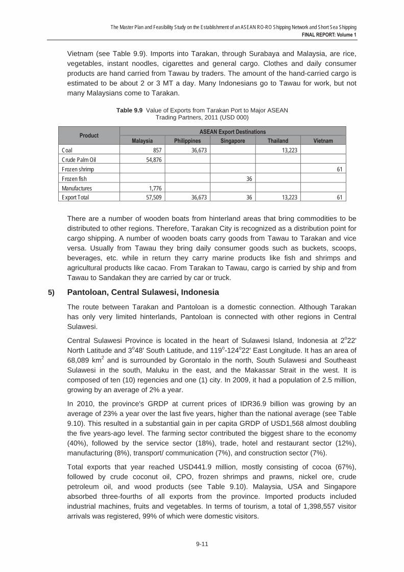
Vietnam (see Table 9.9). Imports into Tarakan, through Surabaya and Malaysia, are rice, vegetables, instant noodles, cigarettes and general cargo. Clothes and daily consumer products are hand carried from Tawau by traders. The amount of the hand-carried cargo is estimated to be about 2 or 3 MT a day. Many Indonesians go to Tawau for work, but not many Malaysians come to Tarakan.
Table 9.9 Value of Exports from Tarakan Port to Major ASEAN Trading Partners, 2011 (USD 000)
Product ASEAN Export Destinations Malaysia Philippines Singapore Thailand Vietnam
Coal 857 36,673 13,223 Crude Palm Oil 54,876 Frozen shrimp 61 Frozen fish 36 Manufactures 1,776 Export Total 57,509 36,673 36 13,223 61
There are a number of wooden boats from hinterland areas that bring commodities to be distributed to other regions. Therefore, Tarakan City is recognized as a distribution point for cargo shipping. A number of wooden boats carry goods from Tawau to Tarakan and vice versa. Usually from Tawau they bring daily consumer goods such as buckets, scoops, beverages, etc. while in return they carry marine products like fish and shrimps and agricultural products like cacao. From Tarakan to Tawau, cargo is carried by ship and from Tawau to Sandakan they are carried by car or truck.
5) Pantoloan, Central Sulawesi, Indonesia
The route between Tarakan and Pantoloan is a domestic connection. Although Tarakan has only very limited hinterlands, Pantoloan is connected with other regions in Central Sulawesi.
Central Sulawesi Province is located in the heart of Sulawesi Island, Indonesia at 2o22' North Latitude and 3o48' South Latitude, and 119o-124o22' East Longitude. It has an area of 68,089 km2 and is surrounded by Gorontalo in the north, South Sulawesi and Southeast Sulawesi in the south, Maluku in the east, and the Makassar Strait in the west. It is composed of ten (10) regencies and one (1) city. In 2009, it had a population of 2.5 million, growing by an average of 2% a year.
In 2010, the province's GRDP at current prices of IDR36.9 billion was growing by an average of 23% a year over the last five years, higher than the national average (see Table 9.10). This resulted in a substantial gain in per capita GRDP of USD1,568 almost doubling the five years-ago level. The farming sector contributed the biggest share to the economy (40%), followed by the service sector (18%), trade, hotel and restaurant sector (12%), manufacturing (8%), transport/ communication (7%), and construction sector (7%).
Total exports that year reached USD441.9 million, mostly consisting of cocoa (67%), followed by crude coconut oil, CPO, frozen shrimps and prawns, nickel ore, crude petroleum oil, and wood products (see Table 9.10). Malaysia, USA and Singapore absorbed three-fourths of all exports from the province. Imported products included industrial machines, fruits and vegetables. In terms of tourism, a total of 1,398,557 visitor arrivals was registered, 99% of which were domestic visitors.
The Master Plan and Feasibility Study on the Establishment of an ASEAN RO-RO Shipping Network and Short Sea Shipping FINAL REPORT: Volume 1
9-12
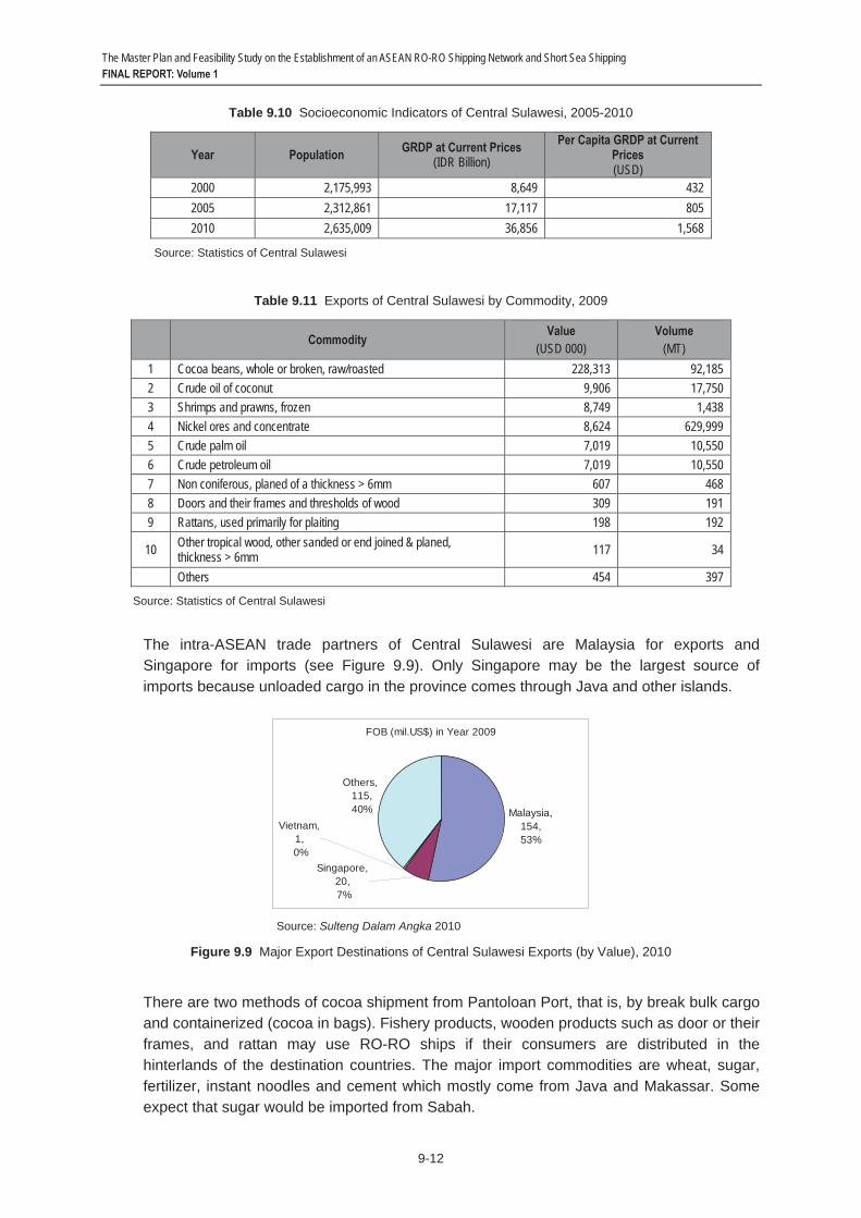
Table 9.10 Socioeconomic Indicators of Central Sulawesi, 2005-2010
Year Population GRDP at Current Prices (IDR Billion)
Per Capita GRDP at Current Prices (USD)
2000 2,175,993 8,649 432 2005 2,312,861 17,117 805 2010 2,635,009 36,856 1,568
Source: Statistics of Central Sulawesi
Table 9.11 Exports of Central Sulawesi by Commodity, 2009
Commodity Value (USD 000)
Volume (MT)
1 Cocoa beans, whole or broken, raw/roasted 228,313 92,185 2 Crude oil of coconut 9,906 17,750 3 Shrimps and prawns, frozen 8,749 1,438 4 Nickel ores and concentrate 8,624 629,999 5 Crude palm oil 7,019 10,550 6 Crude petroleum oil 7,019 10,550 7 Non coniferous, planed of a thickness > 6mm 607 468 8 Doors and their frames and thresholds of wood 309 191 9 Rattans, used primarily for plaiting 198 192
10 Other tropical wood, other sanded or end joined & planed, thickness > 6mm 117 34
Others 454 397
Source: Statistics of Central Sulawesi
The intra-ASEAN trade partners of Central Sulawesi are Malaysia for exports and Singapore for imports (see Figure 9.9). Only Singapore may be the largest source of imports because unloaded cargo in the province comes through Java and other islands.
Source: Sulteng Dalam Angka 2010
Figure 9.9 Major Export Destinations of Central Sulawesi Exports (by Value), 2010
There are two methods of cocoa shipment from Pantoloan Port, that is, by break bulk cargo and containerized (cocoa in bags). Fishery products, wooden products such as door or their frames, and rattan may use RO-RO ships if their consumers are distributed in the hinterlands of the destination countries. The major import commodities are wheat, sugar, fertilizer, instant noodles and cement which mostly come from Java and Makassar. Some expect that sugar would be imported from Sabah.
FOB (mil.US$) in Year 2009
Vietnam,1,
0%Singapore,
20, 7%
Others, 115, 40% Malaysia,
154,53%
The Master Plan and Feasibility Study on the Establishment of an ASEAN RO-RO Shipping Network and Short Sea Shipping FINAL REPORT: Volume 1
9-13
Palu is Central Sulawesi's capital city and main gateway, including Mutiara Airport and Pantoloan. The city serves as the province's trade, commercial, financial, educational, health, and tourism center and is home to about 500,000 people.
The vision of the Provincial Government of Central Sulawesi is to develop Palu as "the North Gate of Indonesia." For this purpose, the local government continues to develop the city's infrastructure to stimulate business activities. This includes a 150-ha industrial zone for cacao, fisheries and other agribusiness processing; improvement/ expansion of the airport, main seaport and smaller ports; fishing port in Toli-Toli; tourism facilities development; hydropower development; and possibly a canal cutting across Tomini Bay and Makassar Strait from east to west.
The province continues to promote its tourism products such as nice white sand beaches, dive sites and sailing (for example, the "Sail Tomini" yachting event from Australia). Tourists come mainly by air but also sometimes by cruise ship, as had happened in the recent past when 2 cruise ships from UK and Germany (via Singapore and Makassar) called on Pantoloan Port and another docked in anchorage in Donggala Port, 60 km from Palu, which is nearer the dive sites.
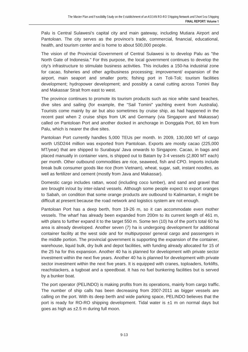
Pantoloan Port currently handles 5,000 TEUs per month. In 2009, 130,000 MT of cargo worth USD244 million was exported from Pantoloan. Exports are mostly cacao (225,000 MT/year) that are shipped to Surabaya/ Java onwards to Singapore. Cacao, in bags and placed manually in container vans, is shipped out to Batam by 3-4 vessels (2,800 MT each) per month. Other outbound commodities are rice, seaweed, fish and CPO. Imports include break bulk consumer goods like rice (from Vietnam), wheat, sugar, salt, instant noodles, as well as fertilizer and cement (mostly from Java and Makassar).
Domestic cargo includes rattan, wood (including coco lumber), and sand and gravel that are brought in/out by inter-island vessels. Although some people expect to export oranges to Sabah, on condition that some orange products are outbound to Kalimantan, it might be difficult at present because the road network and logistics system are not enough.
Pantoloan Port has a deep berth, from 19-26 m, so it can accommodate even mother vessels. The wharf has already been expanded from 200m to its current length of 461 m, with plans to further expand it to the target 550 m. Some ten (10) ha of the port's total 60 ha area is already developed. Another seven (7) ha is undergoing development for additional container facility at the west side and for multipurpose/ general cargo and passengers in the middle portion. The provincial government is supporting the expansion of the container, warehouse, liquid bulk, dry bulk and depot facilities, with funding already allocated for 15 of the 25 ha for this expansion. Another 40 ha is planned for development with private sector investment within the next five years. Another 40 ha is planned for development with private sector investment within the next five years. It is equipped with cranes, toploaders, forklifts, reachstackers, a tugboat and a speedboat. It has no fuel bunkering facilities but is served by a bunker boat.
The port operator (PELINDO) is making profits from its operations, mainly from cargo traffic. The number of ship calls has been decreasing from 2007-2011 as bigger vessels are calling on the port. With its deep berth and wide parking space, PELINDO believes that the port is ready for RO-RO shipping development. Tidal water is ±1 m on normal days but goes as high as ±2.5 m during full moon.

The Master Plan and Feasibility Study on the Establishment of an ASEAN RO-RO Shipping Network and Short Sea Shipping FINAL REPORT: Volume 1
9-14
9.2 Corridor-wide Traffic 1) Johor – Sintete
Figure 9.10 The Routes of Subsidized Pioneer Shipping Service between Sintete and Tj. Pinang
The Study Team did not observe any shipping service between Johor and Sintete during the field survey.
There may be some cargo demand on the route. The Study Team collected some piecemeal information about the demand to be detoured through the Natuna islands, the ports in Riau such as Tanjung Pinang and the ports in Sumatra such as Dumai. The Entikong-Tebedu land crossing border between West Kalimantan and Sarawak may help such detoured service. However, combined cargo volumes may be only marginal.
In terms of route distance, the Natuna detour route is the second best to direct shipping. But this route is operated by government subsidy to offset revenue deficit.
Table 9.12 Land Cross-Border Trade at Entikong – Tebedu Border, 2000-2006
Year Export to West Kalimantan Import from West Kalimantan
2000 6,726,794 9,080,618 2001 5,743,240 12,658,958 2002 12,658,743 21,214,300 2003 36,160,111 18,516,408 2004 18,293,427 22,770,619 2005 15,532,862 23,638,920 2006 17,917,986 35,352,587
Note: US$
Source: Statistical Department, Sarawak
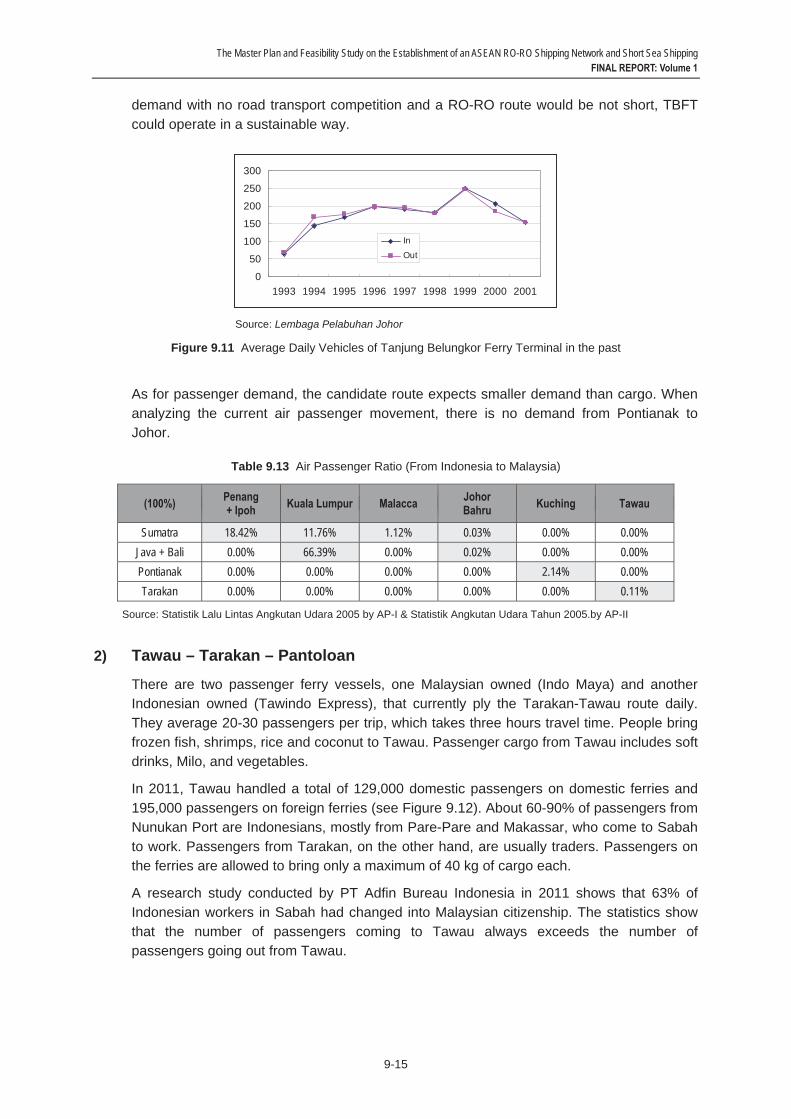
The Study Team collected a bit old data from Tanjung Belungkor Ferry Terminal (TBFT) which is the vehicle traffic using RO-RO service between TBFT and Changi, Singapore. One reason to suspend the service is the location of TBFT. If there would be enough
The Master Plan and Feasibility Study on the Establishment of an ASEAN RO-RO Shipping Network and Short Sea Shipping FINAL REPORT: Volume 1
9-15
demand with no road transport competition and a RO-RO route would be not short, TBFT could operate in a sustainable way.
Source: Lembaga Pelabuhan Johor
Figure 9.11 Average Daily Vehicles of Tanjung Belungkor Ferry Terminal in the past
As for passenger demand, the candidate route expects smaller demand than cargo. When analyzing the current air passenger movement, there is no demand from Pontianak to Johor.
Table 9.13 Air Passenger Ratio (From Indonesia to Malaysia)
(100%) Penang + Ipoh Kuala Lumpur Malacca Johor
Bahru Kuching Tawau
Sumatra 18.42% 11.76% 1.12% 0.03% 0.00% 0.00% Java + Bali 0.00% 66.39% 0.00% 0.02% 0.00% 0.00% Pontianak 0.00% 0.00% 0.00% 0.00% 2.14% 0.00% Tarakan 0.00% 0.00% 0.00% 0.00% 0.00% 0.11%
Source: Statistik Lalu Lintas Angkutan Udara 2005 by AP-I & Statistik Angkutan Udara Tahun 2005.by AP-II
2) Tawau – Tarakan – Pantoloan
There are two passenger ferry vessels, one Malaysian owned (Indo Maya) and another Indonesian owned (Tawindo Express), that currently ply the Tarakan-Tawau route daily. They average 20-30 passengers per trip, which takes three hours travel time. People bring frozen fish, shrimps, rice and coconut to Tawau. Passenger cargo from Tawau includes soft drinks, Milo, and vegetables.
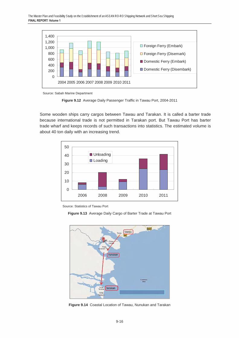
In 2011, Tawau handled a total of 129,000 domestic passengers on domestic ferries and 195,000 passengers on foreign ferries (see Figure 9.12). About 60-90% of passengers from Nunukan Port are Indonesians, mostly from Pare-Pare and Makassar, who come to Sabah to work. Passengers from Tarakan, on the other hand, are usually traders. Passengers on the ferries are allowed to bring only a maximum of 40 kg of cargo each.
A research study conducted by PT Adfin Bureau Indonesia in 2011 shows that 63% of Indonesian workers in Sabah had changed into Malaysian citizenship. The statistics show that the number of passengers coming to Tawau always exceeds the number of passengers going out from Tawau.
0
50
100
150
200
250
300
1993 1994 1995 1996 1997 1998 1999 2000 2001
In
Out
The Master Plan and Feasibility Study on the Establishment of an ASEAN RO-RO Shipping Network and Short Sea Shipping FINAL REPORT: Volume 1
9-16
Source: Sabah Marine Department
Figure 9.12 Average Daily Passenger Traffic in Tawau Port, 2004-2011
Some wooden ships carry cargos between Tawau and Tarakan. It is called a barter trade because international trade is not permitted in Tarakan port. But Tawau Port has barter trade wharf and keeps records of such transactions into statistics. The estimated volume is about 40 ton daily with an increasing trend.
Source: Statistics of Tawau Port
Figure 9.13 Average Daily Cargo of Barter Trade at Tawau Port
Figure 9.14 Coastal Location of Tawau, Nunukan and Tarakan
0200400600800
1,0001,2001,400
2004 2005 2006 2007 2008 2009 2010 2011
Foreign Ferry (Embark)
Foreign Ferry (Disemark)
Domestic Ferry (Embark)
Domestic Ferry (Disembark)
0
10
20
30
40
50
2006 2008 2009 2010 2011
UnloadingLoading

The Master Plan and Feasibility Study on the Establishment of an ASEAN RO-RO Shipping Network and Short Sea Shipping FINAL REPORT: Volume 1
9-17
The Tarakan Airport is already considered an international airport, with MAS Wings servicing the Tawau-Tarakan route thrice a week. About 20-30% of Tawau residents are Indonesians who travel across regularly. There are also flights from Tarakan to Nunukan twice a day, and from Tarakan to Balikpapan thrice a day.
Between Tarakan and Pantoloan, there is even no domestic RO-RO service available. From Tarakan, its counterpart port in Sulawesi is Toli-toli due to the shortest strait crossing.
PT. ASDP operates a regular RO-RO ferry service between Palu (at Taipa Port several kilometers away from Pantoloan Port) and Balikpapan twice a week. The 1,100 GT RO-RO vessel has a capacity of 200 passengers, 22 cars and 70 MT cargo (general). The vessel is already 9 years old and has average load factors of 30% passengers, 45-60% cars, and 80% cargo (to Balikpapan, but no cargo in return). Travel time takes 24 hours at 8-9 knots speed. ASDP considers its lone vessel old and in need of interior and safety maintenance. ASDP operations receive a 40% subsidy from the Ministry of Transport. Cargo from Taipa is mostly fruits, vegetables and cattle, and a few trucks and used cars from Balikpapan. Traffic in Taipa is relatively low. Especially during peak season (e.g., Christmas, Lebaran) when the Taipa terminal becomes congested, most passengers from Palu to Balikpapan choose to use the better vessels from Mamuju City, West Sulawesi.2 To promote increased traffic demand, an option is to operate a newer and bigger (1,000 passenger capacity) RO-RO ferry between Taipa and Balikpapan, which will reduce travel time to only 11 hours at 17 knots speed. Taipa Port has a parking area for 70 cars and enough space in the passenger lounge. However, its bridge ramp has been broken for 6 months now so the vessel's door ramp is being used instead.
2 This route is served by two vessels operated by PT Dharma Lautan Utama and PT Jembatan Madura.
The Master Plan and Feasibility Study on the Establishment of an ASEAN RO-RO Shipping Network and Short Sea Shipping FINAL REPORT: Volume 1
9-18
9.3 Port Operation and Infrastructure 1) Tanjung Belungkor Ferry Terminal
(1) Overview of the Port
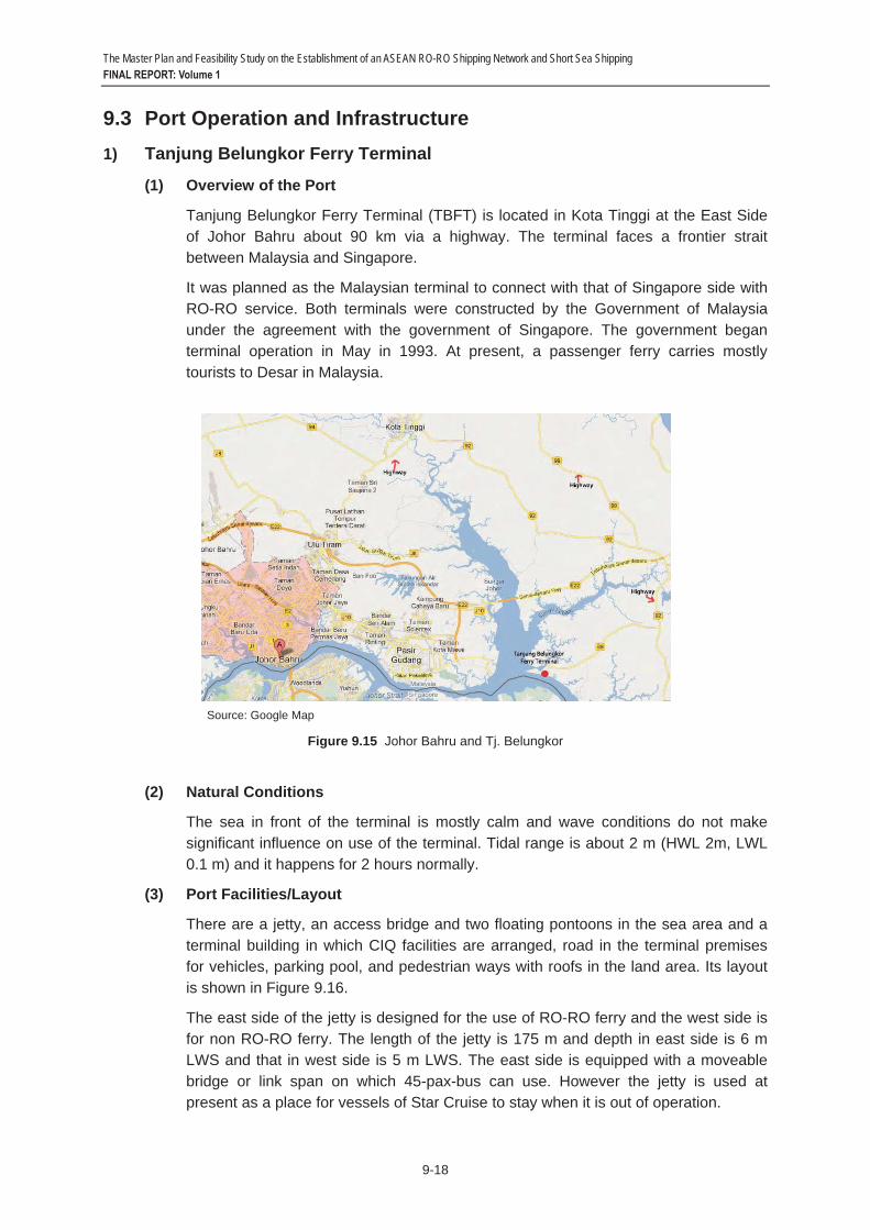
Tanjung Belungkor Ferry Terminal (TBFT) is located in Kota Tinggi at the East Side of Johor Bahru about 90 km via a highway. The terminal faces a frontier strait between Malaysia and Singapore.
It was planned as the Malaysian terminal to connect with that of Singapore side with RO-RO service. Both terminals were constructed by the Government of Malaysia under the agreement with the government of Singapore. The government began terminal operation in May in 1993. At present, a passenger ferry carries mostly tourists to Desar in Malaysia.
Source: Google Map
Figure 9.15 Johor Bahru and Tj. Belungkor
(2) Natural Conditions
The sea in front of the terminal is mostly calm and wave conditions do not make significant influence on use of the terminal. Tidal range is about 2 m (HWL 2m, LWL 0.1 m) and it happens for 2 hours normally.
(3) Port Facilities/Layout
There are a jetty, an access bridge and two floating pontoons in the sea area and a terminal building in which CIQ facilities are arranged, road in the terminal premises for vehicles, parking pool, and pedestrian ways with roofs in the land area. Its layout is shown in Figure 9.16.
The east side of the jetty is designed for the use of RO-RO ferry and the west side is for non RO-RO ferry. The length of the jetty is 175 m and depth in east side is 6 m LWS and that in west side is 5 m LWS. The east side is equipped with a moveable bridge or link span on which 45-pax-bus can use. However the jetty is used at present as a place for vessels of Star Cruise to stay when it is out of operation.

The Master Plan and Feasibility Study on the Establishment of an ASEAN RO-RO Shipping Network and Short Sea Shipping FINAL REPORT: Volume 1
9-19
The terminal is also equipped with two floating pontoons to accommodate passenger ferries with a smaller size. The depth of the seas at the pontoons is 4 m LWS. In addition, fuel oil and fresh water bunker facilities are installed.
In the passenger building, there is a waiting room with 150 seats. The parking area can accommodate 70 vehicles. The traffic lines of vehicles and passengers are divided between inbound and outbound passengers for safety and convenience of users.
Figure 9.16 Layout of Tanjung Belungkor Ferry Terminal
(4) Management and Operation
Johor Port Authority (LPJ) is responsible for managing the ferry terminal. LPJ was incorporated in 1976 under the Port Authorities Act, 1963 and the operation of the ports under LPJ was privatized in principle under the Privatization Act 1990. This terminal has been managed and operated by LPJ itself but after June 2012, the terminal operation has been privatized. The current operator is Marina Island.
The contract with Marina Island is a 5+5 method. The first contract is 5 years and then it can be prolonged for another 5 years. Finally the contract may be extended up to 30 years. But in terms of concession fee, it will be receivable every year.
Regarding CIQS, the available facilities are security posts, police station, immigration office, and a passenger waiting room. The terminal area is designated as the restricted zone and necessary measures for securing security have been taken according to the ISPS code.

The Master Plan and Feasibility Study on the Establishment of an ASEAN RO-RO Shipping Network and Short Sea Shipping FINAL REPORT: Volume 1
9-20
(5) Connection with Hinterland
Tanjung Belungkor Ferry Terminal is about 100 km away from the downtown of Johor Bahru but it is linked to the urban area by well-maintained roads such as Expressway E22 (Senai – Desar Expressway) and Federal Road Routes 92 and 89 and it takes less than two hours to go there from Johor Bahru. The traffic volumes are low (several thousand vehicles daily) on the two-lane and 8-meter-wide access road to the port due to very low population density. The access road can accommodate 20-ft container trailers. Therefore, if a RO-RO service is introduced in the Johor – Sintete route, vehicles might not affect the land transportation but improvement of access roads would be necessary to allow entrance of 40-ft container trailers and other heavy vehicles.
The Expressway E22 which bridges the Johor River is concurrently the ASEAN Highway No.18 therefore TBFT is connected with this trunk road with a branch access road. Although Expressway E22 is not designated as Transit Transport Route in the ASEAN Highway network, but it is connected to North-South Expressway E2, a Designated Transit Transport Route of ASEAN Highway No. 2 at its one end.
(6) Future Development
LPJ intends to maximize the fresh water supply, cargo handling and barter trade and to revive vehicle-carrying ferries to Singapore and ferry services in Malaysia and to nearby tourist areas.
(7) Topics of RO-RO Terminal
From 1993 to 2001 Syarikat Ferry link Sdn. Bhd., a subsidiary of MBF (M) Sdn. Bhd. was the operator running the RO-RO ferry operation between the terminal and Changi terminal. The ferry can carry 450 passengers and 70 vehicles. In 2002, the operator was replaced by the company whose name is Sea Ferry but it closed the service in 2010.
Marina Island Company which will take over the rights of the operation of the terminal in June 2012 plans to revive RO-RO services to Singapore.
2) Port of Sintete
(1) Overview of the Port
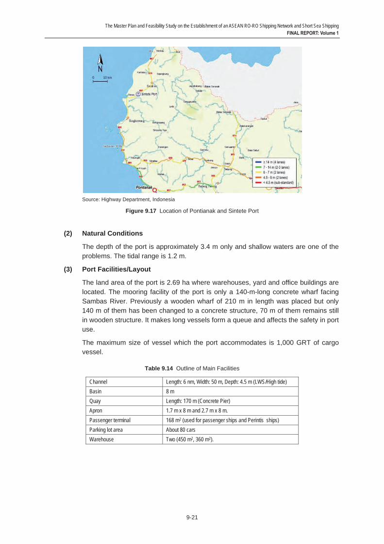
Sintete Port is located in Semparuk district, Sambas regency in West Kalimantan and faces the Sambas River. The port is a river port to serve sea transportation. Singkawang and Sambas are the nearest cities to which it takes 60 minutes by land transport and Pontianak which is a capital city of West Kalimantan Province is located about 200 km south of the port.
Sintete port is classified as a pilot port with small activity.
The Master Plan and Feasibility Study on the Establishment of an ASEAN RO-RO Shipping Network and Short Sea Shipping FINAL REPORT: Volume 1
9-21
Source: Highway Department, Indonesia
Figure 9.17 Location of Pontianak and Sintete Port
(2) Natural Conditions
The depth of the port is approximately 3.4 m only and shallow waters are one of the problems. The tidal range is 1.2 m.
(3) Port Facilities/Layout
The land area of the port is 2.69 ha where warehouses, yard and office buildings are located. The mooring facility of the port is only a 140-m-long concrete wharf facing Sambas River. Previously a wooden wharf of 210 m in length was placed but only 140 m of them has been changed to a concrete structure, 70 m of them remains still in wooden structure. It makes long vessels form a queue and affects the safety in port use.
The maximum size of vessel which the port accommodates is 1,000 GRT of cargo vessel.
Table 9.14 Outline of Main Facilities
Channel Length: 6 nm, Width: 50 m, Depth: 4.5 m (LWS/High tide) Basin 8 mQuay Length: 170 m (Concrete Pier) Apron 1.7 m x 8 m and 2.7 m x 8 m. Passenger terminal 168 m2 (used for passenger ships and Perintis ships) Parking lot area About 80 cars Warehouse Two (450 m2, 360 m2).

The Master Plan and Feasibility Study on the Establishment of an ASEAN RO-RO Shipping Network and Short Sea Shipping FINAL REPORT: Volume 1
9-22
Source: JICA Study Team
Figure 9.18 Layout of Sintete Port
(4) Management and Operation
This port is operated under management of Sintete Port of PT (Persero) Pelabuhan Indonesia (Pelindo II).
CIQS is not available in this port and CIQS buildings and infrastructures are left damaged and only security posts and customs office are available. Previously, the Immigration Agency has an office to manage any foreigner but it is inactive at present.
(5) Connection with Hinterland
Sintete port can be reached by land transport about 5 hours (± 200 km) driving from Pontianak and about 1 hour (50 km) driving from the nearest cities, Singkawang and Sambas. The road access from Pontianak to Sintete is classified as moderate condition with a width of only 8 meters. Most of the road users are fully loaded trucks and private vehicles. A large number of overloaded trucks damage the pavement condition on some sections of the Pontianak – Singkawang – Sambas road. Those trucks usually bring goods from Sambas to Pontianak and vice versa. Several trucks also enter Sintete Port for loading and unloading goods. This situation makes the access road to the port heavily damaged. The Pontianak – Singkawang – Sambas road and roads in Sintete city need a strict control of overloading as well as improvement and expansion.
Sintete has no specific regulation to control truck movement in the city. All kinds of trucks are allowed to access major roads from/to the port and the city area. However, since the road capacity and size are limited and also the conditions are mostly damaged, trucks only use certain roads/corridors for their movements. Additionally, motorcycles cause traffic congestions in Sintete city.
In relation to the ASEAN Highway Network, the nearest road section from Sintete lies between Pontianak and Entikong (ASEAN Highway No. 150). It means there is more or less 200 km long to gain access to the ASEAN Highway from Sintete. Road improvement and expansion is necessary between Sintete and Pontianak in terms of the access to ASEAN Highway.

The Master Plan and Feasibility Study on the Establishment of an ASEAN RO-RO Shipping Network and Short Sea Shipping FINAL REPORT: Volume 1
9-23
(6) Future Development
Dredging work will start in September 2012.
(7) Topics of RO-RO Terminal
No information has been obtained that the port received RO-RO vessels.
3) Port of Tawau
(1) Overview of the Port
Tawau Port is one of six ports scattered in the State of Sabah, Malaysia. Tawau old wharf was first established in 1969. Nowadays Tawau Port has several general cargo/container berths for ships of up to 10,000 DWT and one oil jetty for ships up to 10,000 DWT.
Tawau Port is the third largest port after Kota Kinabalu and Sandakan. The port serves as a major timber and agricultural products export center.
The maximum size of vessel which the port accommodates is 202 m in length and 9.5 m in draught.
Figure 9.19 Location of Tawau
(2) Natural Conditions
The tidal difference of the waters in the port is about 2.4 m in mean spring range. Regarding largest tidal difference, the statistics shows 3.6 m but the port operator experienced 5 m.
High sedimentation is a major issue for Tawau port, especially on main wharves. Every two years Sabah Ports Sdn. Bhd. allocates MYR5-6 million for maintenance dredging. The last dredging was conducted in 2009.
(3) Port Facilities/Layout
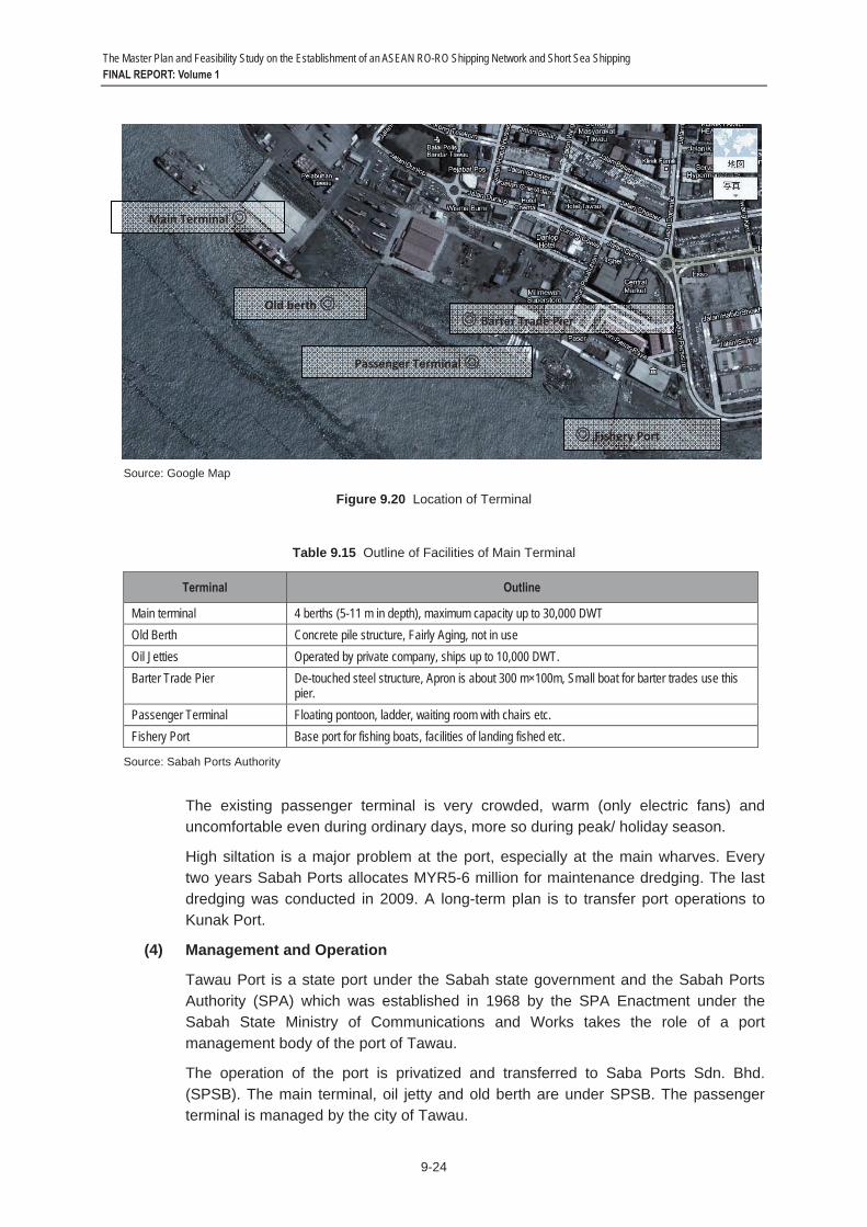
There are several terminals and mooring facilities along the shoreline of the city of Tawau. The main facilities in the port are: the main terminal, which is a distribution center of seaborne cargo, an old berth which is not active due to aging of facilities, a barter trade pier which is used for barter trade, a passenger terminal with pontoon type mooring facilities, fishery ports and oil jetties. Their layout is shown in Figure 9.20. Oil jetties are located north-west of main terminal about 10 km away.
The outline of these terminals is summarized in Table 9.15.
The Master Plan and Feasibility Study on the Establishment of an ASEAN RO-RO Shipping Network and Short Sea Shipping FINAL REPORT: Volume 1
9-24
Source: Google Map
Figure 9.20 Location of Terminal
Table 9.15 Outline of Facilities of Main Terminal
Terminal Outline
Main terminal 4 berths (5-11 m in depth), maximum capacity up to 30,000 DWT Old Berth Concrete pile structure, Fairly Aging, not in use Oil Jetties Operated by private company, ships up to 10,000 DWT. Barter Trade Pier De-touched steel structure, Apron is about 300 m×100m, Small boat for barter trades use this
pier. Passenger Terminal Floating pontoon, ladder, waiting room with chairs etc. Fishery Port Base port for fishing boats, facilities of landing fished etc.
Source: Sabah Ports Authority
The existing passenger terminal is very crowded, warm (only electric fans) and uncomfortable even during ordinary days, more so during peak/ holiday season.
High siltation is a major problem at the port, especially at the main wharves. Every two years Sabah Ports allocates MYR5-6 million for maintenance dredging. The last dredging was conducted in 2009. A long-term plan is to transfer port operations to Kunak Port.
(4) Management and Operation
Tawau Port is a state port under the Sabah state government and the Sabah Ports Authority (SPA) which was established in 1968 by the SPA Enactment under the Sabah State Ministry of Communications and Works takes the role of a port management body of the port of Tawau.
The operation of the port is privatized and transferred to Saba Ports Sdn. Bhd. (SPSB). The main terminal, oil jetty and old berth are under SPSB. The passenger terminal is managed by the city of Tawau.
Old berth
Fishery Port
Main Terminal
Barter Trade Pier
Passenger Terminal

The Master Plan and Feasibility Study on the Establishment of an ASEAN RO-RO Shipping Network and Short Sea Shipping FINAL REPORT: Volume 1
9-25
Administrative agencies such as customs, immigration authority and quarantine authority are located at the port where they conduct their duties. It has CIQ facilities with X-Ray scanner but processing is slow due to the many passengers.
(5) Connection with Hinterland
The port is located in front of the downtown of Tawau City but vehicles from/to the port may not give severe influence to urban traffic. Inter-city roads are satisfactory. Nowadays it is 2-hour driving between Tawau and Sandakan on a stretch of 160 km.
The road to Sandakan and Kota Kinabalu is also designated as the ASEAN Highway No.150. However this section is not designated as Transit Transport Route. The ASEAN Highway alignment extends to East Kalimantan, Indonesia on the map. As a matter of fact, the border crossing at Serudong (Sabah) – Simanggaris (East Kalimantan) is not operational.
(6) Future Development
The construction work of a new passenger terminal building, including customs facilities, is on-going at the area near the present passenger terminal in order to expand its capacity.
(7) Topics of RO-RO Terminal
In the port, RO-RO terminal is neither existing nor planned by the responsible authority.
4) Port of Tarakan
(1) Overview of the Port
There are two ports that serve passengers and goods in Tarakan City, Malundung Port (in the city center) and Juwata Laut Port (in North Tarakan Sub District, or about 12 km from the city center). Malundung port (the port of Tarakan) is located at the west coast of the Pulau Bunyu Island. The port is a main port of Tarakan City and classified as a National Port with the main function as a logistics center of the island. Recently, the government of Tarakan City is promoting the port status to be an export port for specific products.

The Master Plan and Feasibility Study on the Establishment of an ASEAN RO-RO Shipping Network and Short Sea Shipping FINAL REPORT: Volume 1
9-26
Figure 9.21 Location of the Port of Tarakan
(2) Natural Conditions
The sea depth surrounding the port ranges from 3 m to 5 m and the sea depth reaches 10 to 20 m beyond the 3 km radius to the northern sea of Tarakan Island. The tidal range of high tide reaches about 3.2 m and the low tide 0.1 m. The high water level and low water level in spring is 3.78 m and 0.15 m, respectively. The wind velocity and current velocity near the port is 10 knots and 3 knots, respectively. (PELINDO IV Annual Report 2009)
(3) Port Facilities/Layout
The area of the port is 21.6 ha hectares, composed of: water area of 17.22 ha and land area of 4.38 ha. The mooring facility is placed about 350 m from the shoreline and it is connected by three 350-m–long trestles. It consists of four jetties and their outlines are summarized in Table 9.16 and the layout of facilities is shown in Figure 9.22.
Table 9.16 Jetties and Trestles
Jetties Length (m) Width (m) Structure Jetty I 75 15 Reinforced Concrete Jetty II 100 9 Reinforced Concrete Jetty III 75 15 Reinforced Concrete Jetty IV 130 25 Reinforced Concrete
Trestles Length (m) Width (m) Structure Passenger Trestle 350 3 Wood
Old Trestle 350 6 Reinforced Concrete New Trestle 350 5 Reinforced Concrete
Source: PELINDO IV
The port of Tarakan

The Master Plan and Feasibility Study on the Establishment of an ASEAN RO-RO Shipping Network and Short Sea Shipping FINAL REPORT: Volume 1
9-27
Figure 9.22 The Layout of the Port of Tarakan
(4) Management and Operation
The Tarakan Port Administrator takes the role as the port authority of the port. On the other hand, PELINDO IV takes the role of the operator of the port. Juwata Laut Port is operated by PT. ASDP.
State administrative agencies such as customs, immigration authority and quarantine authority are located in the port and conduct their duties there.
(5) Connection with Hinterland
The access road to Malundung Port is about 12 meters wide and has sufficient capacity with four lanes. The access road is paved with asphalt in good condition and is supported by road direction boards and marks. However, the load capacity is only 10 tons. In terms of local policy, there is no specific regulation for trucks or container trailers to use the city roads.
Tarakan Island is not connected with the ASEAN Highway network. Tarakan City Government in coordination with East Kalimantan Provincial Government plans to construct a regional bridge connecting Tarakan – Sadau – Bulungan on main island of Kalimantan, with total length about 1 km (Tarakan – Sadau) and 4 km (Sadau – Kalimantan Mainland) by 2014.
Since containers need not to be brought out from the port under current cargo movement patterns, road improvements will not be necessary unless the island is highly industrialized. However, the roads would have to be renovated to accommodate 40 ft container trailers when the island is connected to the planned Pan Kalimantan Highway in the mainland via the regional bridge which results in demands for trucking containers.
The Master Plan and Feasibility Study on the Establishment of an ASEAN RO-RO Shipping Network and Short Sea Shipping FINAL REPORT: Volume 1
9-28
(6) Future Development
Several projects for improving the port infrastructure are planned as shown in Table 9.17. A port layout according to Port Master Plan 2030 is shown is Figure 9.23.
5) Port of Pantoloan
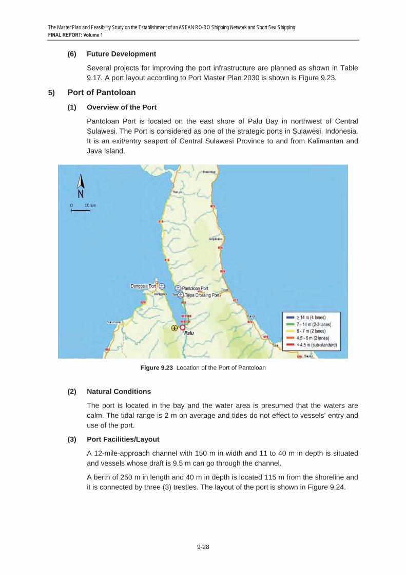
(1) Overview of the Port
Pantoloan Port is located on the east shore of Palu Bay in northwest of Central Sulawesi. The Port is considered as one of the strategic ports in Sulawesi, Indonesia. It is an exit/entry seaport of Central Sulawesi Province to and from Kalimantan and Java Island.
Figure 9.23 Location of the Port of Pantoloan
(2) Natural Conditions
The port is located in the bay and the water area is presumed that the waters are calm. The tidal range is 2 m on average and tides do not effect to vessels’ entry and use of the port.
(3) Port Facilities/Layout
A 12-mile-approach channel with 150 m in width and 11 to 40 m in depth is situated and vessels whose draft is 9.5 m can go through the channel.
A berth of 250 m in length and 40 m in depth is located 115 m from the shoreline and it is connected by three (3) trestles. The layout of the port is shown in Figure 9.24.

The Master Plan and Feasibility Study on the Establishment of an ASEAN RO-RO Shipping Network and Short Sea Shipping FINAL REPORT: Volume 1
9-29
Figure 9.24 Layout of Pantoloan Port
(4) Management and Operation
The port is under the management of PELINDO IV Pantoloan. Security posts and gates and multifunction room for customs and immigration activities are located in the port.
(5) Connection with Hinterland
Sulawesi Island is not included in ASEAN Highway network but Trans-Sulawesi road network is available. It is an important to link Palu, Mamuju, Pare-pare and Makassar by maintaining the west coastal road in a good condition. In addition, a planned toll road between Palu and Toboil will strengthen the intercity network.
The main road access to port in Palu City is designed for 40-feet container size vehicle. A trans-Sulawesi road network is available and connects Palu and other cities in Sulawesi.
(6) Future Development
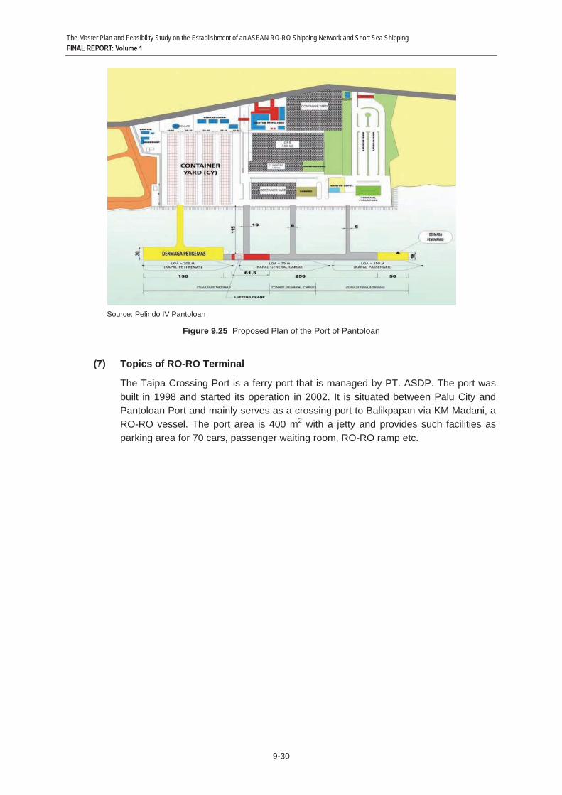
Due to a number of ships queuing’ at the wharf, the expansion of the berth is planned. In addition, construction of the berth for container cargo handling is also planned (See Figure 9.25).
The Master Plan and Feasibility Study on the Establishment of an ASEAN RO-RO Shipping Network and Short Sea Shipping FINAL REPORT: Volume 1
9-30
Source: Pelindo IV Pantoloan
Figure 9.25 Proposed Plan of the Port of Pantoloan
(7) Topics of RO-RO Terminal
The Taipa Crossing Port is a ferry port that is managed by PT. ASDP. The port was built in 1998 and started its operation in 2002. It is situated between Palu City and Pantoloan Port and mainly serves as a crossing port to Balikpapan via KM Madani, a RO-RO vessel. The port area is 400 m2 with a jetty and provides such facilities as parking area for 70 cars, passenger waiting room, RO-RO ramp etc.

The Master Plan and Feasibility Study on the Establishment of an ASEAN RO-RO Shipping Network and Short Sea Shipping FINAL REPORT: Volume 1
9-31
9.4 Shipping Route 1) Johor – Sintete Route
The Johor – Sintete route is one of the longest route in the proposed ASEAN RO-RO Network, covering 321 nautical miles. The voyage will make the passage from the Port of Johor along Johor Strait then out to Singapore Strait, and making the long journey across the open sea to the mouth of Sambas River and then navigating the river channel up to the Port of Sintete. Presently, there is no shipping service along this route.
The Port of Johor is strategically positioned in the heart of the sprawling 8,000 acre Pasir Gudang Industrial Estate, which is home to a comprehensive range of industries specializing in petrochemicals, engineering, furniture, telecommunications, electronic goods and food products among others. The port is located at the southern tip of Peninsular Malaysia, on the eastern shoreline of the Johor Strait. The main channel in the east Johor Strait has a depth of approximately 12.4 m up to the port waterfront and 11.4 m up to Sembawang Shipyard and 10.9 m up to the causeway. Pilotage is compulsory for vessels either exceeding 45 m in length and/or with height structure above 30 m or without any radio communication on board, entering or leaving the port limits. Pilotage service is available 24/7. Notice should be sent to the Harbor Master 24 hours prior to arrival. There are restrictions imposed, such as: recommended speed, reporting, tugs, and others. Please see Figure 9.26.
The Port of Sintete is a small port situated along Sambas River, some six (6) miles from the mouth of the river. The port is located in West Kalimantan, 5 hours from Pontianak City by car. The channel depth is 4.5 m (LWS) and its width is 50m. Due to river navigation and poor port facilities, only small size vessels can be accommodated. Considering the depth of water and port facilities, maximum acceptable size of vessel is less than 1,000GT. Please see Figure 9.27.
See Annex 9.1 for more details.

The Master Plan and Feasibility Study on the Establishment of an ASEAN RO-RO Shipping Network and Short Sea Shipping FINAL REPORT: Volume 1
9-32
Source: Google Earth
Figure 9.26 Port Channel at Johor
Source: Google Earth
Figure 9.27 Port Channel at Sintete
To Johor
To Sintete
Port of Johor
Port of Sintete

The Master Plan and Feasibility Study on the Establishment of an ASEAN RO-RO Shipping Network and Short Sea Shipping FINAL REPORT: Volume 1
9-33
2) Tawau – Tarakan – Pantoloan Route
This route has an international leg (Tawau – Tarakan) and a domestic leg (Tarakan – Pantoloan). The Tawau – Tarakan leg is a short voyage of eighty-two (82) nautical miles along the northeastern coastline of Borneo, traversing the Malaysia – Indonesia border. The Tarakan – Pantoloan leg is an open sea voyage of some 281 nautical miles, from northeast Borneo to Central Sulawesi. Tawau and Tarakan are traditionally strong trading partners. Presently, there is a viable passenger service, using fast crafts, between Tawau and Tarakan. As of yet, there is no maritime service between Tarakan and Pantoloan.
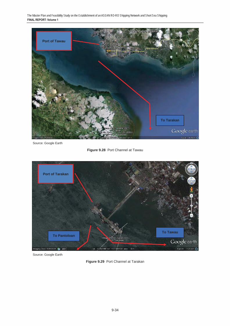
The Port of Tawau is the third largest port in Sabah. It serves the thriving trading city of Tawau. Navigating in the approaches to the port is straight forward. Sometimes, there are numerous fishing boats near the entrance to the port, but they generally keep out of the fairway. The port has service depths of 5 – 11 m. Pilotage is not compulsory, although a pilot is available from 06.00-18.00 hrs. Advance notice should be given 24 hours prior to actual time that pilot service is required. The controlling draft is 9.5 m. Please see Figure 9.28.
The Port of Tarakan serves as the gateway for the island of Tarakan, an island in Kalimantan Timur of Indonesia, off the northeast coast of Borneo. Its approach channel has a length of 21 miles, a of width 1,500 m, and a depth of 9 – 15 m. Pilotage is compulsory, and vessels should call Tarakan Guard Station or raise “G” flag to request a pilot. The port operates 24/7. Vessel less than 10.0 m draft may enter/exit channel at any time. Please see Figure 9.29.
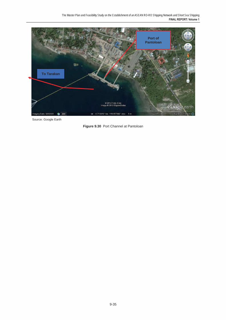
Pantoloan Port serves as the cargo port of the City of Palu. There is another port in the city (Port of Donggala) that is operated by ASDP, which caters to RO-RO shipping. It is located on the east shore of Palu Bay in NW Central Sulawesi. The approach channel has a length of 12 miles, width of 150 m, and depths ranging from 11.0 – 40.0 m. Pilotage is compulsory, and vessels should call Pantoloan Coast Station or raise “G” flag to request a pilot. The port operates 24/7. There are no restrictions due to tides or weather. However, when ships enter at night, they must be careful as there are many fishing boats active in the area. The controlling draft is 9.5 m. Please see Figure 9.30.
See Annex 9.1 for more details.
The Master Plan and Feasibility Study on the Establishment of an ASEAN RO-RO Shipping Network and Short Sea Shipping FINAL REPORT: Volume 1
9-34
Source: Google Earth
Figure 9.28 Port Channel at Tawau
Source: Google Earth
Figure 9.29 Port Channel at Tarakan
Port of Tawau
To Tarakan
Port of Tarakan
To Tawau To Pantoloan
The Master Plan and Feasibility Study on the Establishment of an ASEAN RO-RO Shipping Network and Short Sea Shipping FINAL REPORT: Volume 1
9-35
Source: Google Earth
Figure 9.30 Port Channel at Pantoloan
Port of Pantoloan
To Tarakan
The Master Plan and Feasibility Study on the Establishment of an ASEAN RO-RO Shipping Network and Short Sea Shipping FINAL REPORT: Volume 1
9-36
9.5 CIQS The CIQS facilities and services vary greatly among the five (5) ports. At the lowest rank would be the Port of Sintete (Indonesia), which does not have CIQS facilities since the port is no longer in operation for international routes. It only has a small multi-function room and customs office.
At the Port of Johor (Malaysia), there is an Immigration Office and a Passenger Waiting Room. At the terminal, they have an X-Ray Machine and a Walkthrough Metal Detector. The port CIQS system is mostly operated for passengers and their hand carried baggages,hence, many inspection activities are conducted in handling passengers and their baggages.
At the Port of Pantoloan (Indonesia), there is a Multifunction Room, which functions for Customs and Immigration activities, instead of Ticketing, Passenger Waiting Room, and Information. Since most of the traffic are domestic, there are no significant immigration and only very limited customs activities in the port area.
At the high end would be the two ports of Tawau (Sabah) and Tarakan (Indonesia), both of have comprehensive CIQS equipment, including X-Ray Machines, Walkthrough Metal Detector, Handheld Metal Detector, CCTV cameras, etc. These two ports are traditional partner ports, many citizens have relatives at either side. This contributes to the high volume of passenger traffic but also presents a problem in controlling the movement of illegal immigrants.
The Port of Tawau adopts the “Single-window” system where customs, immigration and security checks are done in a single corridor.
The Port of Tarakan adopts a semi-integrated system, where Customs and Immigration are located in different sites (but still in port area). Therefore, customs officers found some difficulties in doing regular inspection effectively. Moreover, port visitors and porters are allowed to enter the wharf area, which causes difficulties in goods sterilization and passengers inspection. CIQS services operate from 8:00 a.m. to 4:00 p.m. The City of Tarakan imposes a restriction on the use of city streets by big trucks since most of roads are narrow and the axle load capacity is limited (only two lanes per direction and 9 tons capacity).
If the ASEAN RO-RO project would be pushed through, the port authorities have committed to support its development. The Port of Sintete intends to integrate CIQS services, by moving Immigration Office, which is located 60 km from the port (in Singkawang City) to the port area, together with existing Custom Office building. The Port of Johor intends to add inspection equipment, such as cargo x-ray and to redesign Customs, Immigration and Quarantine in a single window system. The Port of Pantoloan plans the separation of passengers and goods lanes (include inspection point) in the port area, the establishment of a specific passenger waiting room with enough (and adjustable) space for customs and immigration inspection activities, the procurement of CIQS tools and equipment for inspections, and the improvement of port security, especially the establishment of regular patrol boats in Pantoloan sea area. The Port of Tarakan intends to further improve their existing CIQS services and facilities.
Table 9.17 and Table 9.18 show the CIQS facilities and systems at the Ports of Sintete, Johor, Tawau, Tarakan and Pantoloan.

The Master Plan and Feasibility Study on the Establishment of an ASEAN RO-RO Shipping Network and Short Sea Shipping FINAL REPORT: Volume 1
9-37
Table 9.17 CIQS Facility Condition in Sintete and Tanjung Belungkor (Johor)
Item Sintete (Indonesia) Johor (Malaysia) Port Name Sintete Port Tanjung Belungkor (Ferry Terminal)
CIQS Facility
Building Security Post Small Multifunction Room Customs Office
Security Post and GatesImmigration Office Passenger Waiting Room
Facility Sintete Port CIQS has not been supported by CIQS facilities since the port is no longer in operation for international routes
X-Ray MachineWalkthrough Metal Detector Permanent Fence Temporary Fence
CIQS Service Service Hours No operation No specific informationOperational System Sintete Port CIQS has no longer in operation due to
inactive international routes The port CIQS system is mostly operated for passengers (and passengers hand carriages)
Major Issues No specific major issue No specific information
Coordination with other country
Cross-border Agreement
• Sintete has not implemented any Govt to Govt agreement or cooperation with neighboring countries. However, in terms of Kalimantan Island, there is a Cross Border Agreement between Kalimantan Government representing Indonesian Government, and Sarawak Government representing Malaysian Government. The agreement allows people and vehicle movement between two country’s borders especially from sea and land to enhance bilateral trading activity. It was signed in August 1970, as a realization of Overland Border Trade proposed by two countries in 1967. The agreement says trading activities by sea and land transport are freely-allowed, particularly in 5 Districts in Kalimantan (Indonesia) and 32 Subdistricts in Sarawak (Malaysia). As an impact of the agreement, a significant number of people moving by cars and buses increase every year between Indonesia and Malaysia borders via Entikong.
• Coordination between Indonesian government and Malaysian government were taken several times to solve the treatment differences between Indonesian side and Malaysian side regarding cross border vehicle in addition to the Kalimantan-Sarawak agreement.
• So far, Indonesia government follows Ministry of Finance Regulation Number 142/2011 regarding Temporary Import, where cross-border vehicles will be treated as temporary import product which given free import duty. However, the regulation mentions if in order to prevent smuggling, customs will ask for cash or custom bond that is released by insurance company or bank guarantee as a safety guarantee. This safety guarantee will be released back at the time when the vehicle going back to origin country
• According to regulation, the amount of money released for safety guarantee is equivalent with the price of import duty for its vehicle, usually about 40% to 50% of its vehicle price
• In additions, in terms of wider region, as a part of ASEAN, this port which located under BIMP-EAGA, IMT-GT and ASEAN agreements, will follow those agreement points which mainly regulate integration of cross border trade, immigration, and vehicle.
Johor has not engaged to any agreement in government to government (G to G) concept with neighboring countries regarding cross border vehicle. However, Malaysia government stipulated two requirements for cross border vehicle, which among others: (1) one international circulation permit issued by Road Transport Agency of Malaysia (valid for 90 days free of charge and 1 day process), and (2) safety insurance for vehicle. In this case, Malaysia recognizes Malaysian and Singaporean insurance. Therefore, Indonesian, Thailand or other countries cross border vehicle want to enter Malaysia gate, they should pay for these insurance from the third party, usually informed in the Immigration Office/gates.

The Master Plan and Feasibility Study on the Establishment of an ASEAN RO-RO Shipping Network and Short Sea Shipping FINAL REPORT: Volume 1
9-38
Export-Import Custom Office in Sintete Port used to process export and import of CPO, spare parts CPO mills and also machinery equipment
Since the existing port serves for passengers, hence many inspection activities conducted in handling passengers hand carriages
Other related matters
Regulation for Truck and Port
No specific regulation provided by the government to control truck movement
No specific regulation provided by the government to control truck movement
Future CIQS Improvement Plan
There is no specific plan from Sintete Port, however if RO-RO ASEAN service operated in Sintete, the important plan to be realized is the integrated CIQS service, by moving Immigration Office which located 60 km from the port (in Singkawang City) to port area, together with existing Custom Office building.
CIQS implementation will be improved to cover the possibility of cargo arrivals if RO-RO ASEAN Operated. The improvement plan are as follows: • Adding inspection tools such as cargo x-ray and
security posts • Redesign Customs, Immigration and Quarantine in a
single window system

The Master Plan and Feasibility Study on the Establishment of an ASEAN RO-RO Shipping Network and Short Sea Shipping FINAL REPORT: Volume 1
9-39
Table 9.18 CIQS Facility Condition in Tawau, Tarakan and Pantoloan
Item Tawau (Malaysia) Tarakan (Indonesia) Pantoloan Port Name Tawau Port Malundung Port Pantoloan Port
CIQS Facility
Building Security Post and Gates Police Station Security Station Customs Office Immigration Office Quarantine Office Passenger Waiting Room Secure Parking
Security Post and GatesPolice Station Customs Office Immigration Office Quarantine Office Passenger Waiting Room Secure Parking
• Security Post and Gates • Multifunction Room (50 m x
20m) which functioned for Customs and Immigration activities instead of Ticketing, Passenger Waiting Room, and Information
Facility X-Ray Machine Walkthrough Metal Detector Handheld Metal Detector CCTVCCTV Monitor Room Permanent Fence Temporary Fence Access Card Gate with Access Card Mirror Inspection for Vehicle Street Poles and Lights
X-Ray MachineWalkthrough Metal Detector Handheld Metal Detector CCTVCCTV Monitor Room Permanent Fence Temporary Fence Access Card Gate with Access Card Mirror Inspection for Vehicle Street Poles and Lights
No specific information
CIQS Service
Service Hours No specific information Irregular (Mostly 08:00 – 16:00) Irregular Operational System The operation system adopts
Single window system with custom, immigration and security checks are done in a single corridor and more integrated area.
• The operation system adopts semi-integrated system, where Custom and Immigration are located in different side (but still in port area). Therefore custom officers found some difficulties in doing regular inspection effectively, especially when related to hand-carry goods and cargoes. For instance, cargo from the vessel must be picked to loading area, then continue to custom area, and put back in the wharf area.
• Port visitors and porters are allowed to enter wharf area, this condition causes difficulties in goods sterilization and passengers inspection
The port operates adequate security system, however since most of vessels and passengers coming are domestic, there are no significant immigration and only limited customs activities in port area.
Major Issues • Unofficial trades between Tarakan – Tawau
• Illegal immigrant (mostly from Tarakan to Tawau)
• Unofficial trades between Tarakan – Tawau
• Illegal immigrant (mostly from Tarakan to Tawau)
• Uncoordinated inspections conducted by many agencies, on-shore and off-shore
• Unintegrated and limited space of Custom, Immigration, and Quarantine Office
• Dangerous goods smuggling activities (bomb, guns, and other illegal weapons)
• Export tax management especially for cocoa exporter
Coordination with other country
Cross-border Agreement
• Coordination between Indonesian government and Malaysian government were taken several times to solve passengers and vehicles treatment differences between
• Coordination between Indonesian government and Malaysian government were taken several times to solve passengers and vehicles treatment differences between
There is no specific agreement related to Pantoloan and closest border countries such as Philippines and Malaysia.
In additions, as a part of ASEAN,

The Master Plan and Feasibility Study on the Establishment of an ASEAN RO-RO Shipping Network and Short Sea Shipping FINAL REPORT: Volume 1
9-40
Indonesian side and Malaysian side
• Tawau has not engaged to any agreement in government to government (G to G) concept with neighboring countries regarding cross border vehicle. However, Malaysia government stipulated two requirements for cross border vehicle, which among others: (1) one international circulation permit issued by Road Transport Agency of Malaysia (valid for 90 days free of charge and 1 day process), and (2) safety insurance for vehicle. In this case, Malaysia recognize Malaysian and Singaporean insurance. Therefore, Indonesian, Thailand or other countries cross border vehicle want to enter Malaysia gate, they should pay for these insurance from the third party, usually informed in the Immigration Office/gates.
• In additions, as a part of ASEAN, this port which located under BIMP-EAGA and ASEAN agreements, will follow those agreement points which mainly regulate integration of cross border trade, immigration, and vehicle. The specific aspects related are as follows: (1) Recognition of country domestic driving license and vehicle inspection (2) Handling on left hand driving and right hand driving (3) Tax and Insurance for cross border vehicle
Indonesian side and Malaysian side
• So far, Indonesia government follows Ministry of Finance Regulation Number 142/2011 regarding Temporary Import, where cross-border vehicles will be treated as temporary import product which given free import duty. However, the regulation mentions if in order to prevent smuggling, customs will ask for cash or custom bond that is released by insurance company or bank guarantee as a safety guarantee. This safety guarantee will be released back at the time when the vehicle going back to origin country
• According to regulation, the amount of money released for safety guarantee is equivalent with the price of import duty for its vehicle, usually about 40% to 50% of its vehicle price.
this port which located under BIMP-EAGA and ASEAN agreements, will follow those agreement points which mainly regulate integration of cross border trade, immigration, and vehicle. The specific aspects related are as follows: (1) Recognition of country domestic driving license and vehicle inspection (2) Handling on left hand driving and right hand driving (3) Tax and Insurance for cross border vehicle
Export-Import Tawau Customs handles bulk palm oil, crude oil and general cargo. There are large coconut and rubber estates in the developed area within 10 miles of the town, all of which are major exports. Timber continues to be the principal export.
Customs mostly handles vegetables, fishery products, plywood, clothes for export commodities, while for import commodities are such as fish, toys, crackers, beverages, electronics. To be noted, several type of commodity are come informally.
Most of the export commodities passing through Pantoloan Port are cocoa products. However, Customs is improving tax collection system since many exporters ignored their tax payment.
Other related matters
Regulation for Truck and Port
No specific regulation provided by the government to control truck movement
Truck is prohibited to access city roads, since most of road width and capacity are limited (only two lanes per direction and 9 tons capacity)
No specific regulation provided by the government to control truck movement
Future CIQS Improvement Plan
No specific information CIQS implementation will be improved based on several actions among others: • Making faster administration
checking activity with complete input and output of manifest and crew record data.
• Improvement of quarantine activity, by expanding quarantine and warehouse stock rooms
CIQS implementation will be improved based on several actions among others: • Separation of passengers and
goods lanes (include inspection point) in port area
• Specific passenger waiting room establishment with enough (and adjustable) space for customs and immigration inspection

The Master Plan and Feasibility Study on the Establishment of an ASEAN RO-RO Shipping Network and Short Sea Shipping FINAL REPORT: Volume 1
9-41
9.6 Stakeholders’ Views 1) Johor – Sintete
Stakeholders in Johor see some opportunities for connecting with Indonesia. Among the future plans that may impact on traffic between Johor and Sintete are the following:
(1) Johor Bahru plans to operate a Lego Park (a theme park like Disneyland) by the end of 2012. It will become a good attraction for local and foreign visitors.
(2) Johor needs many workers since many industries have developed. It may be possible for Sintete to send many workers to Johor. Workers from Vietnam, Myanmar and Nepal can also be target sources of foreign workforce.
(3) In the next two years there will be around 40 new hotels available in Johor Bahru to boost its tourism industry.
(4) The local government wants to position Johor Bahru for health and education tourism, with its many good hospitals and schools.
It was informed that by June 2012, Tanjung Belungkor Ferry Terminal will be operated by a private company named Marina Island (from the Marina Island Group). The new terminal operator is planning to revive RO-RO services from Tanjung Belungkor to Singapore. However, in terms of regulation and facilities, TBFT may not be ready for cargo RO-RO operations. The terminal is only allowed passenger ferry operations so cargo services may have to be directed to cargo terminals such as Tanjung Pelepas, etc. The port ramp or Link Span can accommodate up to medium-sized bus of 45-person capacity, but maybe not big trucks or container cargo movement.
• Improvement of integrated checking room for Custom and Immigration with redesign of shelter, passengers and goods corridors (lanes), product room (warehouse), and separation of domestic and international passenger room as well as adding facility such as additional X-ray, CCTV, and security gates
• ID Card system will be implemented to control/identify people in port area. There will be two types of ID Card, for workers (drivers, potters, etc) and port management.
• Coordination for security checking, in order to solve double checking and illegal checking by other agencies or organization outside Port Authority and related agencies
• The Immigration Office planned to establish a new regulation to handle passengers and goods database implementation and special treatment for people with no free visa (non ASEAN).
activities • Procurement of CIQS tools and
equipment for inspections. • Security improvement especially
the establishment of regular patrol boats in Pantoloan sea area as a realization of national regulation that select Pantoloan Port as a one of the security central point

The Master Plan and Feasibility Study on the Establishment of an ASEAN RO-RO Shipping Network and Short Sea Shipping FINAL REPORT: Volume 1
9-42
Local stakeholders in Sintete/ Sambas are aware of how cargo transport from their area has shifted over the years from Sintete Port to the much bigger and better Pontianak Port. They feel that the possible opening of the Sintete-Johor sea transport route would support trade development. However, trucking the cargo from Sambas through Entikong to Kuching where it is shipped to Port Klang is still the cheaper transport alternative because of the subsidized transport at the Malaysian side. At almost 300 miles, Sintete and Johor may be very far from each other and, if ever, would need larger vessels which would then require expansion of Sintete Port's facilities. Another possible route that may be explored is Sintete – Natuna (Serasan – Ranai – Medai) – Tembelan – Tanjung Pinang – Batam – Johor/ Singapore. At present, subsidized pioneering service is provided between Sintete and Tanjung Pinang by PT. ASDP.
2) Tawau – Tarakan – Pantoloan
There is no existing RO-RO shipping service between Tawau and Tarakan. If merited, the Sabah Ports can probably develop it but it needs sustainable volume and probably subsidy from the government. RO-RO vessels (for delivering cars) now only go to Kota Kinabalu, where car carriers deliver the vehicles to Tawau and other parts of Sabah.
At present, there seems to be little potential for RO-RO shipping between Tawau and Nunukan due to the small cargo volumes and shallow waters around these islands. Local ship owners currently use only small container vessels. RO-RO cargo shipping may not be feasible at this time.
A local passenger ferry operator, however, thinks otherwise. He believes it would be good to have RO-RO service so passengers can bring their vehicles across. However, he thinks the better route would be Tawau–Nunukan–Pare-Pare–Makassar than Pantoloan since 70% of the population in Tawau comes from Sulawesi. Passenger-wise, there may be potential for ROPAX development between Tawau, Nunukan and Tarakan since an average of 1,000 passengers travel across this route daily.
Some stakeholders in Sabah look at developing international shipping routes as a sort of "chicken-and-egg" issue, whether the transport infrastructure and service or the volume should come first. They believe that the business community should initiate trade to develop sustainable cargo volumes that would merit opening up new shipping routes/ services. The Sabah Ports, for example, built CIQS facilities at Semporna Port in 2010 to service passengers from Bongao, Tawi-Tawi but there were no takers, mainly due to the lack of marketing of the service in the Philippine side and that Filipinos from Bongao need to go all the way to Zamboanga to have their passports stamped.
In contrast, there is a lot of trade between Tawau and Simpati Island (shared border between Malaysia and Indonesia). Freight costs depend on cargo volume, so costs become higher if there is no backload on the vessels. What governments can do is (i) to stimulate production by attracting more external investments; (ii) build more factories to increase cargo volumes; and (iii) offer incentives to shipping operators on developmental routes (e.g., subsidies, long-term financing arrangements).
The current commercial cargo transactions between Tarakan and Tawau is considered as "illegal trade" since they remain unregulated, at least at the Indonesian side. This cargo, shipped on traditional wooden-hulled boats from Tarakan include instant noodles, crackers, cigarettes, clothes, etc. In return, traders bring from Tawau beverage, snacks, milk, egg, cake, fruits, beef, chicken, vegetables, etc. Some of the Indonesian goods brought to

The Master Plan and Feasibility Study on the Establishment of an ASEAN RO-RO Shipping Network and Short Sea Shipping FINAL REPORT: Volume 1
9-43
Tawau are traded onwards to the Philippine islands of Tawi-Tawi and Zamboanga. The traders have been organized with the help of the Tarakan Chamber of Commerce and Industry (KADIN). However, there are frequent incidents of traders running into problems with CIQS authorities (e.g., difference in CIQS regulations, too many checkpoints, informal fees), which require KADIN to intercede for them with KADIN Malaysia and BIMP-EAGA counterparts. To avoid such issues, KADIN Tarakan sees the need to make this industry more formal and regulated. They welcome the development of RO-RO shipping along this route. Products that can be sold to Malaysia include fish, shrimps, spices, plastic ware and kitchenware (from Surabaya), soap, etc. Tarakan currently has no trading activity with Pantoloan but perhaps opportunities for trading agricultural products may be explored.
The local stakeholders in Central Sulawesi welcome projects that could increase its trade relationships with other countries inasmuch as this would benefit the local economy and local community. The Immigration officials at Pantoloan do not see any problem if international connections to the Philippines or Malaysia are opened. Palu can offer agricultural, mining and fishery products to Malaysia, getting sugar and other daily consumer products in return.

The Master Plan and Feasibility Study on the Establishment of an ASEAN RO-RO Shipping Network and Short Sea Shipping FINAL REPORT: Volume 1
10-1
10 COUNTRY SURVEYS 10.1 Survey Methodology and Scope
The main focus of this chapter is on assessing the legal and institutional readiness of individual ASEAN Member States in facilitating entry and exit of international RO-RO ships.
A harmonized and consistent regional legal and institutional framework is vital for the development and expansion of intra-ASEAN RO-RO shipping services. This involves realigning domestic legal and institutional framework to that of the region. Often, the regional framework is also built upon and consistent with the existing international framework. Hence, adoption and implementation of relevant international conventions and regional agreements represents an important step towards arriving at a harmonized and consistent regional framework.
In this light, the legal and institutional readiness of an ASEAN Member State may be determined by the number of relevant international conventions and regional agreements that the country has acceded, ratified and enforced. Countries that are most ready are usually those that have acceded, ratified and enforced most number of relevant international conventions and regional agreements. Among this group of countries, there should be no major legal and institutional barrier preventing them from facilitating the entry and exit of each other’s RO-RO ships.
The same logic may be applied to participation and implementation of sub-regional and bi-lateral agreements. Considering that a number of the major ASEAN transport agreements are yet to be operationalized, implementation of sub-regional and bi-lateral agreements is a viable interim bottom-up solution to achieving regional integration.
Given the understanding, the level of legal and institutional readiness of an ASEAN Member State is therefore can be determined by assessing the number of relevant international, regional, sub-regional and bi-lateral agreements that the country has acceded and ratified and the extent of which it has enforced/implemented those agreements.
But this provides only a partial picture. Operationally international RO-RO shipping involves intense sea-land interface and effective cross-border coordination. Mindful of this, this report therefore evaluate also the effectiveness of the formalities and procedures adopted by individual ASEAN Member States in facilitating the entry and exit of RO-RO ships as well as passengers, goods and vehicles on board of the ships.
The assessment is of based on the findings of the field surveys conducted in the ten ASEAN Member States during the period March – June 2012. Key findings from literature review have also been incorporated in the report.
This chapter includes analyzing of existing CIQS regulations and formalities of each ASEAN Member State in dealing with international RO-RO shipping operation and their respective domestic laws governing the grant of land transport traffic rights, temporary importation of road vehicle, transport permits, third party vehicle insurance, mutual recognition of domestic driving license, vehicle inspection certificates, vehicle registration certificates, charges for cross-border movement of vehicles, etc. The report does not provide analysis on the legal and institutional framework of the air, rail and inland waterway transport of ASEAN Member States.

The Master Plan and Feasibility Study on the Establishment of an ASEAN RO-RO Shipping Network and Short Sea Shipping FINAL REPORT: Volume 1
10-2
10.2 Brunei Darussalam 1) Administration
The Ministry of Communications is the national agency responsible for the planning, development, coordination and regulation of the transportation system in Brunei Darussalam. Under the Ministry, the Ports Department and Marine Department are responsible for maritime administration while the Land Transport Department is in charge of land transport administration.
2) Legal and Institutional Framework
Port Act 1984 and Merchant Shipping Order 2002 (formerly Merchant Shipping Act 1984) are among the key legislations governing the maritime transport sector of the country.
On the other hand, the Road Transport Act and Motor Transport Licensing Authority Act govern the land transport sector.
The relevant laws and regulations governing the transport logistics services sector are shown in the following table.
Table 10.1 Laws and Regulations Related to Transport Logistics Services Sector in Brunei Darussalam
No. Sub-Sectors Relevant Laws and Regulations 1. Maritime cargo handling services - Company’s Act
- Labour Act - Ports Act,1984, Chapter 144
2. Storage and warehousing services - Company’s Act- Ports Act,1984, Chapter 144 - Customs Order, 2006 - Labour Act
3. Freight transport agency services - Company’s Act - Ports Act, 1984, Chapter 144 - Labour Act
4. Other auxiliary services Company’s Act5. Customs clearance services - Company’s Act
- Customs Order, 2006 - Labour Act
6. International Freight Transportation excluding Cabotage
- Company’s Act- Labour Act
7. International road freight transport services - Company’s Act- Labour Act - Road Transport Act - Motor Transport Licensing Authority Act
Source: Adopted from the ASEAN Secretariat; http://www.asean.org/logisticsservices.htm
3) Ship Registration
The Marine Department is responsible for ship registration. In line with the Ministry of Communication’s vision to make Brunei Darussalam a logistics hub in BIMP-EAGA, the Marine Department has been promoting the registration of Brunei-owned vessels under the Brunei Flag. The first international RO-RO ferry in the BIMP-EAGA region, the MV Shuttle Hope, is registered in Brunei Darussalam.
The Master Plan and Feasibility Study on the Establishment of an ASEAN RO-RO Shipping Network and Short Sea Shipping FINAL REPORT: Volume 1
10-3
4) International Agreements
To date Brunei Darussalam has acceded to/ratified the following 18 IMO conventions/ protocols:
- IMO Convention 48
- IMO amendments 91 - IMO amendments 93
- SOLAS Convention 74 - SOLAS Protocol 78 - LOAD LINES Convention 66
- TONNAGE Convention 69 - COLREG Convention 72
- STCW Convention 78 - IMSO Convention 76
- INMARSAT OA 76 - INMARSAT amendments 98
- MARPOL 73/78 (Annex I/II) - CLC Protocol 76
- CLC Protocol 92 - FUND Protocol 92
- SUA Convention 88 - SUA Protocol 88
Given its relatively small and less complicated administrative set up, Brunei Darussalam has a good record of implementing the IMO conventions and protocols in a timely manner. For example, it signed the International Convention on Standards of Training, Certification and Watchkeeping for Seafarers (1978) on 23 October 1986 and enforced the convention on 23 January 1987; and it signed the International Convention on Civil Liability for Oil Pollution Damage (1969) on 29 September 1992 and enforced it on 28 Dec 1992.
Brunei Darussalam’s main port, Muara, which is part of the ASEAN Network Port system, is ISPS compliant. The Serasa Car Ferry Terminal which supports the existing RO-RO shipping operation between Serasa (Muara, Brunei Darussalam) and Labuan (Malaysia) is also ISPS compliant and is audited by the designated marine authority which is the Marine Department.
5) International Road Transport and Customs Conventions
Brunei Darussalam is not a party to the 1949 Geneva Convention on Road Traffic. However it honors the International Driving Permit issued under the Convention. It is also not a signatory to the following major international transport and customs conventions:
- UN Convention on Road Traffic (1968) (i.e., the Vienna Convention on Road Traffic 1968)
- UN Convention on Road Signs and Signals (1968) (i.e., the Vienna Convention on Road Signs and Signals)
The Master Plan and Feasibility Study on the Establishment of an ASEAN RO-RO Shipping Network and Short Sea Shipping FINAL REPORT: Volume 1
10-4
- Customs Convention on the International Transport of Goods under Cover of TIR (TIR stands for French “Transports Internationaux Routiers” or "International Road Transports") Carnets (1975)
- Customs Convention on the Temporary Importation of Commercial Road Vehicles (1956)
- Customs Convention on Containers (1972)
- International Convention on the Harmonization of Frontier Controls of Goods (1982)
- Convention on the Contract for the International Carriage of Goods by Road (CMR) (1956)
Brunei Darussalam is also not a party to the 1961 Customs Convention on the ATA Carnet for the Temporary Admission of Goods (ATA Convention) and 1990 Convention on Temporary Admission (also known as the Istanbul Convention). It plans to accede to the ATA Convention in 2015 or 2016.
6) Regional Agreements (ASEAN)
At the ASEAN level, Brunei Darussalam is a party to the following transport-related agreements:
- The ASEAN Framework Agreement on the Facilitation of Goods in Transit (AFAFGIT), 1998
- The ASEAN Framework Agreements on Multimodal Transport (AFAMT), 2005
- The ASEAN Framework Agreement on Facilitation of Inter-State Transport (AFAFIST), 2008
- The ASEAN Agreement on Recognition of Commercial Vehicle Inspection Certificate, 1998
- The ASEAN Agreement on Recognition of Domestic Driving License, 1985
- Ministerial Understanding on the Development of the ASEAN Highway Network Project, 1999
- MoU on Cooperation Relating to Marine Casualty and Marine Incident Safety Investigations, 2009
Brunei Darussalam has ratified the AFAFGIT but not the AFAMT and AFAFSIT. Brunei Darussalam has established its NTTCC to implement the AFAFGIT. The NTTCC is chaired by the Permanent Secretary of Ministry of Communications.
7) ASEAN Highway Network
The Brunei Darussalam’s portion of the ASEAN Highway Network is highway numbered AH150. AH150 includes the roads stretching from Sungai Tujoh / Miri (Brunei Darussalam / Malaysia Check Point) to Kuala Lurah / Limbang (Brunei Darussalam / Malaysia Check Point) (with a total length of 140 km) and from Puni / Limbang (Brunei Darussalam / Malaysia Check Point) to Labu / Lawas (Brunei Darussalam / Malaysia Check Point) (28 km). Generally these roads are in good condition with technical design standards and road signs and signals that meet international standards. The maximum vehicle weight capacity that the roads can take is 8 tons per axle load. Among others, the Puni CIQS facilities along the AH150 have been upgraded. Toilets, sign boards, bus/cargo vehicle lanes at other

The Master Plan and Feasibility Study on the Establishment of an ASEAN RO-RO Shipping Network and Short Sea Shipping FINAL REPORT: Volume 1
10-5
border checkpoints are also being upgraded. To date, in line with the requirements of the MoU on the Development of the ASEAN Highway Network Project (1999), Brunei Darussalam has installed common road signs and the route numbering system on all its TTR routes.
8) Sub-regional Agreements (BIMP-EAGA)
Brunei Darussalam is a signatory to the following BIMP-EAGA transport MoUs:
- MoU Cross-Border Movement of Commercial Buses and Coaches, 2007 - MoU on Expansion of Air Linkages, 2007 - MoU on Establishing and Promoting Efficient and Integrated Sea Linkages, 2007
- MoU on Transit and Inter-State Transport of Goods, 2009
Brunei Darussalam has implemented all the four MoUs.
9) Temporary Admission of Road Vehicle
Brunei Darussalam’s Customs Order 2006 and Administrative Rules allow for temporary admission of foreign road vehicles for an initial period of three months. The period can be extended up to six months at the request of the vehicle owners/operators. The amount of security required for such temporary admission is equivalent to the duty involved on the vehicle. The security can be in the form of bank guarantee, general bond and cash. The following documents are required for admission:
- Approval letter from Customs for the temporary admission - Import Permit and supporting documents from other Government Agencies
- Temporary Importation Form (e-customs).
The temporarily admitted vehicles can be re-exported (exit) through a Customs office other than the one through which they were imported (entered).
Despite the above standard customs requirements, Brunei Darussalam has a more flexible bi-lateral and sub-regional arrangements with Malaysia and Indonesia on temporary admission of road vehicles. Under the bi-lateral arrangement between Brunei Darussalam and Malaysia, road vehicles from Sabah and Sarawak are exempted from many of these customs requirements including import duty payment and customs guarantee.
Under the BIMP-EAGA MoU on Cross Border Movement of Commercial Buses and Coaches, a limited number of buses and coaches from Malaysia and Indonesia are allowed to enter Brunei Darussalam on a daily basis without the need to pay any import duty or security. Buses operating under the MoU are however required to secure a vehicle transit pass from the Land Transport Department of Brunei Darussalam to ensure that the vehicles are road worthy. Such requirement reflects the reality that Brunei Darussalam has not fully implemented the 1998 ASEAN Agreement on Recognition of Commercial Vehicle Inspection Certificate.
For transit goods, instead of depositing bonds and bank guarantees which involve a lengthy refund procedure, a transit charge of BD$25 (about US$20) per container of general consignment and BD$100 (about US$78) for dangerous and controlled items are imposed.
Brunei Darussalam recognized the domestic driving issued by Malaysia and Indonesia. It recognizes Malaysia’s third party car insurance but not Indonesia’s as the coverage amount of the latter is considered to be too low by regional standard. Buses from Indonesia are
The Master Plan and Feasibility Study on the Establishment of an ASEAN RO-RO Shipping Network and Short Sea Shipping FINAL REPORT: Volume 1
10-6
therefore required to purchase Brunei Darussalam’s third party car insurance before entering the country. No such requirement is imposed on Malaysian vehicles as the two countries mutually recognize each other’s third party car insurance.
Brunei Darussalam has left-hand traffic, i.e., it uses right hand drive vehicles. It has no problem accepting road vehicles from Indonesia and Malaysia since the two countries also drive on the left. Brunei Darussalam does not allow left hand drive vehicles.
The Frequent Traveler Facility (FTF) meant for citizens of Brunei Darussalam and Malaysia has been undergoing trial run and evaluation since August 2011. Phase 1 of the project covered the border posts in Miri-Sungai Tujoh, Kuala Lurah-Tedungan and Pandaruan-Ujung. The two countries are now in the second phase of implementing the FTF covering the immigration control posts in Labu (Temburong, Brunei Darussalam) - Mengkalap (Lawas, Sarawak) and Serasa (Brunei Darussalam) - Labuan (Malaysia). The facility expedites the immigration inspection process at entry points of both countries. FTF users need only obtain passport verification once every three months as verification and entry or exit activities are recorded electronically using biometric fingerprints which do not require them to fill out disembarkation forms. Professional drivers from the two countries are encouraged and allowed to utilize the facility.
To facilitate vehicles and cargo movement between Brunei Darussalam and Malaysia, the private and public sectors from the two countries have been jointly implementing radio frequency identification (RFID) and web-based tagging technologies to speed up their customs clearance process since early 2011. Through application of machine-readable tags for verification purposes, the system allows for reduction of customs paperwork and minimizes processes required of commercial vehicles when crossing borders.
Brunei Darussalam and Malaysia reached a bi-lateral arrangement in October 2010 to introduce the first international RO-RO ferry service in BIMP-EAGA. It is the only remaining active international RO-RO ferry service in ASEAN. The bi-lateral MoU is an offshoot of the 2007 BIMP-EAGA MoU on Establishing and Promoting Efficient and Integrated Sea Linkages. It represents the combined commitment and effort of the two countries to implement the BIMP-EAGA MoU. The RO-RO ferry service linking Serasa (Brunei Darussalam) and Labuan (Malaysia) began its operation on 4 October 2010. The ferry operator is Syarikat PKL Jaya Sdn Bhd which operates the Brunei-registered MV Shuttle Hope.
The governments of Brunei Darussalam and Malaysia have exempted the ferry operator from paying marine charges and terminal tariff. The ferry operator is required to provide adequate insurance coverage for passenger on board MV Shuttle Hope. Vehicles on board of the ferry are exempted from International Circulation Permit (ICP). In pursuance of the 2009 BIMP-EAGA MoU on Transit and Inter-State Transport of Goods, MV Shuttle Hope is allowed to transport commercial freight vehicles and goods for the Serasa – Labuan sector. The two countries have agreed to facilitate the movement of vehicles and goods for this sector in accordance with the provisions stipulated under the 2009 BIMP-EAGA MoU on Transit and Inter-State Transport of Goods. The Land Transport Department of Brunei Darussalam has emplaced its officers on call at the Serasa Terminal. The ferry operator is required to notify the Department if there are cargo trucks on board from Labuan to Muara. With respect to immigration formalities, ASEAN citizens on entering Brunei Darussalam are exempted from visa. Visa on arrival services are available for non-ASEAN citizens.
The Master Plan and Feasibility Study on the Establishment of an ASEAN RO-RO Shipping Network and Short Sea Shipping FINAL REPORT: Volume 1
10-7
10) Concluding Remarks
Presently Brunei Darussalam is the only country in BIMP-EAGA that owns and operates an international RO-RO shipping service (MV Shuttle Hope). Now with over two years of experience under its belt, Brunei Darussalam’s legal and institutional framework are reasonably attuned to facilitating entry and exit of RO-RO ships, including the passengers and private and commercial vehicles on board of the ships. Brunei Darussalam shared its land borders with Malaysia and its highway AH150 is linked to the AH150 in Sabah and Sarawak. Even prior to the introduction of the Serasa-Labuan RO-RO shipping service, Brunei Darussalam was already familiar with handling of temporary admission of road vehicles from Malaysia. Implementation of the BIMP-EAGA transport MoUs has necessitated Brunei Darussalam to further adjust and streamline its cross-border formalities to better facilitate inter-state and transit vehicles from Indonesia and Malaysia. However, since Brunei Darussalam is not a party to most of the international land transport and customs conventions, and given that the AFAFGIT and AFAFIST are yet to operationalize, it is not so well positioned to facilitate transit and inter-state traffics originating from countries other than Malaysia and Indonesia.
The Master Plan and Feasibility Study on the Establishment of an ASEAN RO-RO Shipping Network and Short Sea Shipping FINAL REPORT: Volume 1
10-8
10.3 Cambodia 1) Administration
The Ministry of Public Works and Transport (MPWT) is a national agency primarily responsible for planning, managing and regulating the transport sector, covering national roads, road transport, railways, ports, inland water transport, coastal and international shipping and airport construction.
The MPWT manages the national and provincial roads, measuring about 10,500 km. National roads include primary national highways and provincial roads are secondary national highways.
The Department of Merchant Marine is an agency set up under the General Department of Transport of the MPWT. It is responsible for the administration of the maritime transport sector.
The Department of Transport within the MPWT is responsible for vehicle registration, inspection and road safety, among others.
2) Legal and Institutional Framework
Cambodia has a relatively young maritime administration. The 20-year (1973-1993) civil war has more or less wiped out the legal and administrative framework that the country inherited from the French colonial administration. However, in 1994, the Merchant Marine Service was re-established. In 1999, the Department of Merchant Marine was set up under the MPWT.
Cambodia is in the process of putting in place a new national maritime legislation. This involves updating and augmenting the existing regulations to comply with international maritime conventions to which Cambodia is a party. Among others, port laws and a legal framework for private ports operations are being developed; ship registration systems are being enhanced to develop national tonnage and improve monitoring of the national fleet; and maritime safety systems are being improved.
The draft legislation is currently being reviewed with Belgian assistance. It was expected that the final draft of the legislation would be ready for tabling at the General Assembly for adoption and enactment in the second half of 2012 or in 2013.
3) International Agreements
Cambodia is a member of the IMO. It has acceded to/ratified 19 IMO conventions/protocols to date, as follows:
- IMO Convention 48
- SOLAS Convention 74 - SOLAS Protocol 78
- SOLAS Protocol 88 - LOAD LINES Convention 66
- LOAD LINES Protocol 88 - TONNAGE Convention 69
- COLREG Convention 72 - STCW Convention 78
The Master Plan and Feasibility Study on the Establishment of an ASEAN RO-RO Shipping Network and Short Sea Shipping FINAL REPORT: Volume 1
10-9
- MARPOL 73/78 (Annex I/II)
- MARPOL 73/78 (Annex III) - MARPOL 73/78 (Annex IV)
- MARPOL 73/78 (Annex V) - CLC Convention 69
- CLC Protocol 76 - CLC Protocol 92
- FUND Protocol 92 - SUA Convention 88 - SUA Protocol 88
However, ratification of these conventions has been slow going and Cambodia does not have a national law to enforce them. Having returned to international shipping in the late 1990s following the protracted civil war, Cambodia finds itself facing resource limitation to translate the conventions into Khmer, the official language of Cambodia and to turn them into national legislations.
Cambodia has yet to implement the ISPS Codes since it does not have the required legal framework to designate an authorized agency to enforce the Codes. Nevertheless, pursuant to the relevant presidential decrees/sub-decrees of the national government, all the major seaports in Cambodia have in one way or the other enforced the measures prescribed under the ISPS Code. The initiative covers the Phnom Penh and Sihanoukville ports, the two Cambodian ports that are part of the ASEAN Network Ports system. Presently there isn’t any foreign RO-RO ship calling at these two ports.
Cambodia is a signatory to a number of international road, transport facilitation and customs agreements. It has ratified the 2004 UNESCAP-initiated Intergovernmental Agreement on the Asian Highway Network which specifies basic technical standards for roads and route signs. Other ASEAN Member States that are also parties to the agreement are Myanmar and Vietnam. The Agreement entered into force in 2005.
In 1971, Cambodia ratified the 1921 Convention and Statute on Freedom of Transit which ensures freedom of transit for various commercial goods across national boundaries. Lao PDR and Thailand are others ASEAN Member States that are parties to convention.
Cambodia is a contracting party to the 1982 United Nations Convention on the Law of the Sea. The convention provides for land-locked countries the right of access to and from the sea. These countries shall enjoy freedom of transit through the territory of transit States by all means of transport. Nevertheless, the terms and modalities for exercising freedom of transit shall be agreed between the land-locked countries and transit states involved through bilateral, subregional or regional agreements.
Cambodia is among the contracting parties to the 1956 Customs Convention on the Temporary Importation of Commercial Road Vehicles, which grants temporary admission without payment of import duties and import taxes and free of import prohibitions and restrictions to vehicles registered in the territory of any of the other contracting parties. Singapore is the only other ASEAN Member States that is party to the convention.
Cambodia is a member of the World Customs Organization (WCO) and ratified the revised Kyoto Convention on the Simplification and Harmonization of Customs Procedures in 2006.
The Master Plan and Feasibility Study on the Establishment of an ASEAN RO-RO Shipping Network and Short Sea Shipping FINAL REPORT: Volume 1
10-10
Regarding quarantine, Cambodia is a party to the WTO Agreement on the Application of Sanitary and Phytosanitary Measures which came into force in 1995. The agreement stipulates constraints on contracting parties' policies relating to food safety (bacterial contaminants, pesticides, inspection and labeling) as well as animal and plant health (phytosanitation) pertaining to imported pests and diseases. Cambodia is also a party to another closely related WTO agreement, namely the Agreement on Technical Barriers to Trade, which aims at ensuring that technical regulations, standards, testing, and certification procedures do not create unnecessary obstacles to trade.
4) Regional Agreements
Cambodia is a signatory to the following ASEAN transport agreements: - The ASEAN Framework Agreement on the Facilitation of Goods in Transit
(AFAFGIT), 1998 - The ASEAN Framework Agreements on Multimodal Transport (AFAMT), 2005
- The ASEAN Framework Agreement on Facilitation of Inter-State Transport (AFAFIST), 2008
- The ASEAN Agreement on Recognition of Commercial Vehicle Inspection Certificate, 1998
- The ASEAN Agreement on Recognition of Domestic Driving License, 1985 - Ministerial Understanding on the Development of the ASEAN Highway Network
Project, 1999 - MoU on Cooperation Relating to Marine Casualty and Marine Incident Safety
Investigations, 2009
Cambodia has ratified the AFAFGIT and AFAMT. It has yet to ratify the AFAFSIT. Cambodia has established its NTTCC to oversee existing cross border transport facilitation arrangements with Lao PDR, Thailand and Vietnam and future implementation of AFAFGIT and Cross-border Transport Agreement (CBTA) of the Greater Mekong Subregion (GMS). The NTTCC of Cambodia is chaired by a Director-General of the Ministry of Public Works and Transport. It has 11 other members, all of whom represent government agencies, including the Ministries of Foreign Affairs, Commerce, Interior, Finance and the Economy, Agriculture, Health and Tourism, the Customs and Civil Aviation Departments, the Central Bank and the National Insurance Company.
The Cambodia’s portions of the ASEAN transit transport routes/Highway Network are as follows:
- AH 1: Poi Pet (Cambodia / Thailand Border) – Sisophon – Phnom Penh – Bavet (Cambodia / Vietnam Border) (574 km in length)
- AH11: Trapeing Kreal (Cambodia / Lao PDR Border) – Stung Treng – Kampong Cham – Phnom Penh – Sihanoukville Port (764 km)
To date the development of AH-11 has been completed. The development of AH-1 is nearing completion. Cambodia has completed the installation of common road signs on all its designated TTR routes. The installation of the harmonized route numbering signs along AH-11 is on-going. Route numbering signs for the routes from Phnom Penh to Sihanoukville Port and from Phnom Penh–Battambang–Poipet (Cambodia/Thailand border) would be installed soon.

The Master Plan and Feasibility Study on the Establishment of an ASEAN RO-RO Shipping Network and Short Sea Shipping FINAL REPORT: Volume 1
10-11
5) Sub-regional and Bi-lateral Agreements
At the sub-regional level, Cambodia acceded to the CBTA of the GMS in 2001 and has ratified all the annexes of CBTA. Cambodia has implemented the various transport facilitation measures of the CBTA at the Bavet (Cambodia) - Moc Bai (Vietnam) border crossing point and Poipet (Cambodia) - Aranyaprathet (Thailand) border crossing point along the GMS Southern Economic Corridor.
A national secretariat has been established to coordinate GMS program activities at the offices of the Council for the Development of Cambodia.
The Cambodia Freight Forwarder Association (CAMFFA) was established in 2004 with the view to enhance the professionalism within the freight forwarding and logistics sectors and facilitate cross-border movement of goods and vehicles. To date, CAMFFA has 29 members. It acts as a government-appointed issuing/guaranteeing organization to provide guarantees for cargo in transit under the GMS-CBTA and related bi-lateral MoUs.
Over the years, Cambodia have concluded a number of bi-lateral transport and trade facilitation agreements with its closest neighbors, i.e. Lao PDR, Thailand and Vietnam, as follows. Many of these bi-lateral agreements represent the initial steps towards the full operationalization of the CBTA.
Cambodia – Lao PDR
a) Agreement on Road Transport between the Government of the Lao People’s Democratic Republic and the Royal Government of Cambodia (1999); and
b) Protocol to Implement the Agreement on Road Transport between the Kingdom of Cambodia and the Lao People’s Democratic Republic (2007).
The Agreement on Road Transport has been operationalized with cross-border bus operation forming the bulk of the services provided under the agreement.
Cambodia – Thailand
a) MoU on the Establishment of the Joint Thailand-Cambodia Committee on Trade between the Government of the Kingdom of Thailand and the Government of the Kingdom of Cambodia (2000); and
b) MoU between the Government of the Kingdom of Thailand and the Royal Government of Cambodia on the Exchange of Traffic Rights for Cross-Border Transport through the Aranyaprathet-Poipet Border Crossing (2008).
Under the MoU on Aranyaprathet-Poipet Border Crossing, the quota for vehicles for cross border operation from each site was set at 40. The two countries may consider increasing the number of quota to meet the market demand. Implementation of the MoU was expected to begin in June 2012.
Cambodia – Vietnam
a) Agreement on the Transit of Goods between the Government of the Socialist Republic of Vietnam and the Government of the Kingdom of Cambodia (1994) and its amendment (2000);
b) Agreement between the Royal Government of Cambodia and the Government of the Socialist Republic of Vietnam on Road Transportation (1998);

The Master Plan and Feasibility Study on the Establishment of an ASEAN RO-RO Shipping Network and Short Sea Shipping FINAL REPORT: Volume 1
10-12
c) Agreement on the Purchase, Sale and Exchange of Goods and Commercial Services in the Border Area between the Government of the Socialist Republic of Vietnam and the Royal Government of Cambodia (2001);
d) Protocol for the Implementation of the Agreement between the Royal Government of Cambodia and the Government of the Socialist Republic of Vietnam on Road Transportation (2005); and
e) MoU between the Government of the Socialist Republic of Vietnam and the Royal Government of Cambodia on the initial implementation of CBTA at Bavet, the Kingdom of Cambodia, and Moc Bai, the Socialist Republic of Vietnam, signed at Phnom Penh, March (2006).
For the arrangement between Bavet and Moc Bai, Cambodia and Vietnam agreed to increase the quota for commercial vehicles (freight trucks and buses) for cross border operation from 40 to 150 in 2009. Lately, in response to the growing market demand, the two governments again raised the quota to 500. The cross-border vehicles permits are valid for one year (see the sections under Lao PDR, Thailand and Vietnam for more information on the implementation of the sub-regional and bi-lateral agreements).
6) Temporary Admission of Road Vehicle
Beyond the above bi-lateral agreements, there are customs restrictions on cross-border movement of commercial and private vehicles in Cambodia imposed by the Customs and Excise Department of Cambodia.
Under the Article 15 of Law on Customs and Ministerial Regulation No. 928 MEF dated 2 October 2008 on Temporary Importation under Temporary Admission Procedures, Cambodia allows temporary admission of road vehicles free of import duty or tax. The vehicles are allowed to be in the country for a period of up to 12 months. This time limit may be extended by Customs at the request in writing prior to the expiration of the time limit. The vehicle owners/operators are required to pay a security in the form of a bank guarantee or cash. The amount of security required will not exceed the estimated duty and tax on the goods, and customs may authorize security of a lesser amount depending on the assessed risk.
With the technical assistance of UNCTAD and financial assistance from World Bank, the Customs and Excise Department has been implementing the Automated System for Customs Data (ASYCUDA World) since 2006. The system helps to speed up the process of clearing goods from Customs and facilitate movement of vehicles. A pilot project of the system was launched at Sihanoukville Port in 2008. Also, a one-stop service window was established in the special economic zone in Bavet with five government agencies represented under one roof. To date ASYCUDA has centralized its server at the customs headquarter building and expanded its operation to a number of check points in the country.
Being a contracting party to the ASEAN Framework Agreement on Visa Exemption (2006), Cambodia exempts citizens of other ASEAN Member States holding valid national passports from visa requirement for a period of stay of up to 14 days from the date of entry. Such ruling is applicable to drivers of foreign (ASEAN) vehicles entering Cambodia.
Cambodia has ratified Protocol 4 of the ASEAN Framework Agreement on the Facilitation of Goods in Transit 1998, which specifies the dimensions for vehicle weight and dimension.
The Master Plan and Feasibility Study on the Establishment of an ASEAN RO-RO Shipping Network and Short Sea Shipping FINAL REPORT: Volume 1
10-13
The maximum vehicle weight allows under the protocol is 38 tons. The bilateral agreements between Cambodia and Lao PDR adopt the ASEAN standards of vehicles. The Agreement on Road Transportation between Cambodia and Vietnam also adopts the ASEAN standards on vehicle dimensions.
In most cases, foreign road vehicles entering Cambodia are allowed only to travel on the transit and inter-state routes designated under the international, regional, sub-regional and bi-lateral agreements which Cambodia is party to.
7) Concluding Remarks
Cambodia has an impressive record of acceding to international conventions/agreements. To date, it has acceded to a relatively large number of international agreements that are critical for international RO-RO shipping operation. However, Cambodia does not have the relevant domestic laws to enforce many of the agreements. The country also finds itself facing resource limitation to turn some of the international agreements into national legislations. To overcome, Cambodia is in the process of putting in place new national legislations and upgrading some of its existing national laws. To address local capacity problem, international assistance has been sought. To a significant extent, the ability of Cambodia to facilitate international operation of RO-RO ships hinges on how soon the country is able to enact the relevant national legislations (such as the new national maritime legislation) and to enforce the related international agreements. Meantime, implementation of the ASEAN, sub-regional and bi-lateral transport agreements will definitely help.
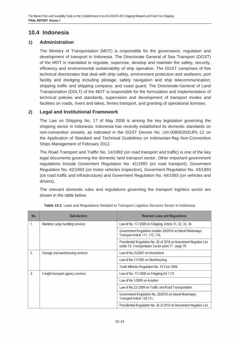
The Master Plan and Feasibility Study on the Establishment of an ASEAN RO-RO Shipping Network and Short Sea Shipping FINAL REPORT: Volume 1
10-14
10.4 Indonesia 1) Administration
The Ministry of Transportation (MOT) is responsible for the governance, regulation and development of transport in Indonesia. The Directorate General of Sea Transport (DGST) of the MOT is mandated to regulate, supervise, develop and maintain the safety, security, efficiency and environmental sustainability of ship operation. The DGST comprises of five technical directorates that deal with ship safety, environment protection and seafarers; port facility and dredging including pilotage; safety navigation and ship telecommunication; shipping traffic and shipping company; and coast guard. The Directorate-General of Land Transportation (DGLT) of the MOT is responsible for the formulation and implementation of technical policies and standards, supervision and development of transport modes and facilities on roads, rivers and lakes, ferries transport, and granting of operational licenses.
2) Legal and Institutional Framework
The Law on Shipping No. 17 of May 2008 is among the key legislation governing the shipping sector in Indonesia. Indonesia has recently established its domestic standards on non-convention vessels, as indicated in the DGST Decree No. Um.008/9/20/DJPL-12 on the Application of Standard and Technical Guidelines on Indonesian-flag Non-Convention Ships Management of February 2012.
The Road Transport and Traffic No. 14/1992 (on road transport and traffic) is one of the key legal documents governing the domestic land transport sector. Other important government regulations include Goverment Regulation No. 41/1993 (on road transport), Goverment Regulation No. 42/1993 (on motor vehicles inspection), Goverment Regulation No. 43/1993 (on road traffic and infrastructure) and Goverment Regulation No. 44/1993 (on vehicles and drivers).
The relevant domestic rules and regulations governing the transport logistics sector are shown in the table below.
Table 10.2 Laws and Regulations Related to Transport Logistics Services Sector in Indonesia
No. Sub-Sectors Relevant Laws and Regulations
1. Maritime cargo handling services Law of No. 17/ 2008 on Shipping, Article 31, 32, 33, 34
Government Regulation number 20/2010 on Inland Waterways Transport Article 111, 115, 116,
Presidential Regulation No. 36 of 2010 on Investment Negative List under 10. Transportation Sector point 17 - page 79.
2. Storage and warehousing services Law of No.25/2007 on Investment
Law of No.11/1965 on Warehousing
Trade Minister Regulation No. 16 Year 2006
3. Freight transport agency services Law of No. 17/ 2008 on Shipping Art 1 (7)
Law of No.1/2009 on Aviation
Law of No.22/ 2009 on Traffic and Road Transportation
Government Regulation No. 20/2010 on Inland Waterways Transport Article 120,121,
Presidential Regulation No. 36 of 2010 on Investment Negative List,

The Master Plan and Feasibility Study on the Establishment of an ASEAN RO-RO Shipping Network and Short Sea Shipping FINAL REPORT: Volume 1
10-15
No. Sub-Sectors Relevant Laws and Regulations
Transportation Sector, page 75, which consists of: - Container Cargo Services - General Cargo Services - Dangerous Goods Transportation Services - Special Cargo Services - Heavy Equipment Cargo Services
4. Other auxiliary services According to Government Regulation No. 20/2010 on Inland Waterways Article 82, these services are the scope of services of Freight Forwarder as Logistics Service Providers
a. Bill auditing Government Regulation No. 20/2010 on Inland Waterways, Article 82
Presidential Regulation No. 36 of 2010 on Investment Negative List under 10.18 –Transportation Sector– Freight Forwarder, page 79.
b. Freight brokerage services Government Regulation No. 20/2010 on Inland Waterways, Article82
Presidential Regulation No. 36 of 2010 on Investment Negative List – Transportation Sector – Freight Forwarder – page 79.
c. Freight inspection Government Regulation No. 20/2010 on Inland Waterways, Article82
Presidential Regulation No. 36 of 2010 on Investment Negative List – Transportation Sector – Freight Forwarder – page 79.
d. Weighing and sampling services Government Regulation No. 20/2010 on Inland Waterways, Article82
e. Cargo condition survey Presidential Regulation No. 36 of 2010 on Investment Negative List – Trade Sector – Survey Services – page 61.
f. Freight receiving and acceptance services Government Regulation No. 20/2010 on Inland Waterways, Article82
Presidential Regulation No. 36 of 2010 on Investment Negative List – Transportation Sector – Freight Forwarder – page 79.
g. Transportation document preparation service Government Regulation No. 20/2010 on Inland Waterways, Article82
Presidential Regulation No. 36 of 2010 on Investment Negative List –Transportation Sector – Freight Forwarder, page 79.
5. Customs clearance services Custom Laws of No. 10 of 1995, Article 29 as amended by No.17 of 2006
6. Finance Minister regulation No. 65/PMK.04/2007 on Customs Brokerage No. PMK. 65 Year 2007:
1) The handling of the Customs Declaration mandatorily required by this law shall be conducted by carriers, importers, or exporters.
2) If the importers or exporters as referred to in paragraph (1) cannot carry out the handling themselves, they may authorize Customs brokers to do it.
7. International freight transportation excluding cabotage Law of No. 17/ 2008 on Shipping
Law of No.1/2009 on Aviation.
Government Regulation No. 20/2010 on Inland Waterways Transport Article 120, 121
Presidential Regulation No. 36 of 2010 on Investment Negative List
Presidential Instruction of Rep of Indonesia No. 5 of 2005 on Empowering National Shipping Industry

The Master Plan and Feasibility Study on the Establishment of an ASEAN RO-RO Shipping Network and Short Sea Shipping FINAL REPORT: Volume 1
10-16
No. Sub-Sectors Relevant Laws and Regulations
8. International rail freight transport services 1. Law of 23/2010 on Rail Transportation 2. Government Regulation no. 56/2009 on Management of Rail
Transportation 3. Government Regulation no. 72/2009 on Traffic and Rail
Transportation
9. International road freight transport services Law of no. 22/2009 on Traffic and Road Transportation Article 139
Source: Adopted from the ASEAN Secretariat; http://www.asean.org/logisticsservices.htm
3) Cabotage
The Law on Shipping No. 17 of 2008 reserves coastal trades for Indonesian-flag vessels, provides operating subsidies for vessels used on selected inter-island routes, provides construction subsidies for vessels used for domestic trades, and requires that crews be Indonesian citizens.
4) International Agreements
Indonesia has acceded to/ ratified 20 IMO Conventions/Protocols, as follows:
- IMO Convention 48 - IMO amendments 91
- IMO amendments 93 - SOLAS Convention 74
- SOLAS Protocol 78 - LOAD LINES Convention 66
- TONNAGE Convention 69 - COLREG Convention 72
- CSC Convention 72 - STCW Convention 78
- STP Agreement 71 - STP Protocol 73
- IMSO Convention 76 - INMARSAT OA 76
- INMARSAT amendments 94 - INMARSAT amendments 98
- FACILITATION Convention 65 - MARPOL 73/78 (Annex I/II)
- CLC Convention 69 - CLC Protocol 92
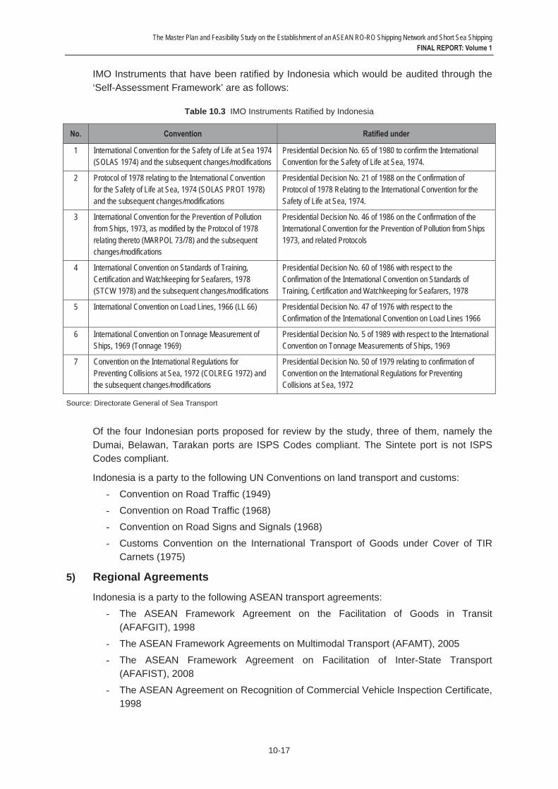
The Master Plan and Feasibility Study on the Establishment of an ASEAN RO-RO Shipping Network and Short Sea Shipping FINAL REPORT: Volume 1
10-17
IMO Instruments that have been ratified by Indonesia which would be audited through the ‘Self-Assessment Framework’ are as follows:
Table 10.3 IMO Instruments Ratified by Indonesia
No. Convention Ratified under
1 International Convention for the Safety of Life at Sea 1974 (SOLAS 1974) and the subsequent changes/modifications
Presidential Decision No. 65 of 1980 to confirm the International Convention for the Safety of Life at Sea, 1974.
2 Protocol of 1978 relating to the International Convention for the Safety of Life at Sea, 1974 (SOLAS PROT 1978) and the subsequent changes/modifications
Presidential Decision No. 21 of 1988 on the Confirmation of Protocol of 1978 Relating to the International Convention for the Safety of Life at Sea, 1974.
3 International Convention for the Prevention of Pollution from Ships, 1973, as modified by the Protocol of 1978 relating thereto (MARPOL 73/78) and the subsequent changes/modifications
Presidential Decision No. 46 of 1986 on the Confirmation of the International Convention for the Prevention of Pollution from Ships 1973, and related Protocols
4 International Convention on Standards of Training, Certification and Watchkeeping for Seafarers, 1978 (STCW 1978) and the subsequent changes/modifications
Presidential Decision No. 60 of 1986 with respect to the Confirmation of the International Convention on Standards of Training, Certification and Watchkeeping for Seafarers, 1978
5 International Convention on Load Lines, 1966 (LL 66) Presidential Decision No. 47 of 1976 with respect to the Confirmation of the International Convention on Load Lines 1966
6 International Convention on Tonnage Measurement of Ships, 1969 (Tonnage 1969)
Presidential Decision No. 5 of 1989 with respect to the International Convention on Tonnage Measurements of Ships, 1969
7 Convention on the International Regulations for Preventing Collisions at Sea, 1972 (COLREG 1972) and the subsequent changes/modifications
Presidential Decision No. 50 of 1979 relating to confirmation of Convention on the International Regulations for Preventing Collisions at Sea, 1972
Source: Directorate General of Sea Transport
Of the four Indonesian ports proposed for review by the study, three of them, namely the Dumai, Belawan, Tarakan ports are ISPS Codes compliant. The Sintete port is not ISPS Codes compliant.
Indonesia is a party to the following UN Conventions on land transport and customs: - Convention on Road Traffic (1949)
- Convention on Road Traffic (1968) - Convention on Road Signs and Signals (1968)
- Customs Convention on the International Transport of Goods under Cover of TIR Carnets (1975)
5) Regional Agreements
Indonesia is a party to the following ASEAN transport agreements: - The ASEAN Framework Agreement on the Facilitation of Goods in Transit
(AFAFGIT), 1998 - The ASEAN Framework Agreements on Multimodal Transport (AFAMT), 2005
- The ASEAN Framework Agreement on Facilitation of Inter-State Transport (AFAFIST), 2008
- The ASEAN Agreement on Recognition of Commercial Vehicle Inspection Certificate, 1998

The Master Plan and Feasibility Study on the Establishment of an ASEAN RO-RO Shipping Network and Short Sea Shipping FINAL REPORT: Volume 1
10-18
- The ASEAN Agreement on Recognition of Domestic Driving License, 1985
- Ministerial Understanding on the Development of the ASEAN Highway Network Project, 1999
- MoU on Cooperation Relating to Marine Casualty and Marine Incident Safety Investigations, 2009
Indonesia has ratified the AFAFGIT but not AFAFSIT and AFAMT. To coordinate the future implementation of the AFAFGIT, Indonesia has established its NTTCC which is chaired by the Secretary-General of Ministry of Transportation.
The following are the Indonesian ports that are part of the ASEAN Port Network system:
Belawan, Dumai, Tanjung Priok, Palembang, Panjang, Pontianak, Tanjung Perak, Tanjung Emas, Makassar, Balikpapan, Bitung, Jayapura, Sorong, and Banjarmasin.
Indonesia has designated the following highways as its transit transport routes (TTR) under the AFAFGIT. It has upgraded 1,762.3 km of its AH 150 and 611.9 km of its AH 151 to Class 3 standard. Rehabilitation of AH-150 in Kalimantan is on-going with ADB’s assistance. A study on identification of route numbering signs is being implemented in three phases over 3 years starting 2011 to 2013 for AH-2 and AH-25. Installation of the route numbering signs in those designated Transit Transport Routes is expected to begin in 2014.
Table 10.4 ASEAN Highway Routes in Indonesia
Highways Length
AH 2: Merak - Jakarta - Surakarta - Surabaya – Denpasar 1,299 km
AH 150: Pontianak - Entikong/Tebedu (Indonesia/Malaysia, Sarawak Border) 321 km
AH 25: Banda Aceh - Medan - Palembang – Bakahuni 2,523 km
6) Sub-regional and Bi-lateral Agreements
Indonesia is a signatory to the following BIMP-EAGA transport MoUs:
- MoU Cross-Border Movement of Commercial Buses and Coaches, 2007 - MoU on Expansion of Air Linkages, 2007
- MoU on Establishing and Promoting Efficient and Integrated Sea Linkages, 2007 - MoU on Transit and Inter-State Transport of Goods, 2009
Indonesia has implemented the first three MoUs. The standard operating procedures (SOPs) of the MoU on Transit and Inter-State Transport of Goods 2009 are presently being finalized.
Indonesia is a party to the IMT-GT framework. However, presently there is no cross-border movement of road vehicle between Indonesia and Malaysia and Indonesia and Thailand under the IMT-GT framework.
The Master Plan and Feasibility Study on the Establishment of an ASEAN RO-RO Shipping Network and Short Sea Shipping FINAL REPORT: Volume 1
10-19
The Socio-Economic Exchange for Malaysia-Indonesia (SOSEK-MALINDO) arrangements allows for movement of private and commercial road vehicles between Kalimantan (Indonesia) and Sarawak (Malaysia). This bi-lateral arrangement pre-dates the BIMP-EAGA arrangement.
7) Temporary Admission of Road Vehicle
Indonesia permits temporary admission of road vehicles to its territory for a period of maximum three years from the date of registration of import customs notification. Governing the temporary admission of road vehicle are the Customs Act Number 17/2006 and Ministry of Finance Decree Number 615 of 2004.
The laws require the vehicle owners/operators to pay a customs security equivalent to the import duties and taxes of the vehicle. The security may be in the form of bank guarantee, customs bond or cash guarantee.
The documents required for temporary admission of a road vehicle are import declaration, insurance premium invoice, license or permit for restricted imports, documents that explain the specifications, identity, the estimated value of the road vehicle, information on port of entry, and location of temporary use of the vehicle, supporting documents certifying that the vehicle will be re-exported, applicant’s identity documents and recommendations from the relevant authorities. Indonesia does not accept other forms of temporary admission papers such as ATA Carnet as it is not a party to the WCO Customs Convention on the ATA Carnet for the Temporary Admission of Goods and Istanbul Convention.
The vehicle can exit Indonesia through a Customs office other than the one through which it was imported.
If the vehicle stays longer than the time period permitted, full import duties and taxes will be imposed on it together with an additional administrative fine of 100 per cent of import duties and taxes due.
In spite of the above standard customs requirements, Indonesia has a more flexible bi-lateral and sub-regional arrangements with Malaysia and Brunei Darussalam on temporary admission of road vehicles.
Under the the SOSEK-MALINDO framework, there are 40 buses servicing the Pontianak-Kuching route, of which 20 buses are from Indonesia and 20 buses from Malaysia. Thebuses from Indonesia are operated by Damri (6 units), Setia Jiwana Sakti (9 units), and PT. Andau Kapuas (2 units). While the buses from Malaysia are operated by Sri Tebakang (3 units), Kirata (3 units), Saphira Pacific (3 units), Sri Merah (3 units), Eva Transport (5 units), and Bintang Jaya Express (3 units).
Under the BIMP-EAGA framework, licensed buses from Brunei Darussalam and Sarawak and Sabah (Malaysia) are allowed to enter Kalimantan on the designated inter-state and transit transport routes.
Under the BIMP-EAGA and SOSEK-MALINDO frameworks, Indonesia recognizes the driving licenses, inspection certificates, registration certificates and insurance policies of Brunei Darussalam and Malaysia (see sections under Brunei Darussalam and Malaysia for more information on this sub-regional arrangement). These vehicles are exempted from import duties and taxes.

The Master Plan and Feasibility Study on the Establishment of an ASEAN RO-RO Shipping Network and Short Sea Shipping FINAL REPORT: Volume 1
10-20
Indonesia uses right hand drive vehicles. Its law prohibits left hand drive vehicles. Left hand drive vehicles need to secure special permit prior to entering the country. Indonesia does not have problem receiving right hand drive road vehicles from Brunei Darussalam and Malaysia (e.g., under the BIMP-EAGA arrangements).
8) Concluding Remarks
The number of IMO conventions/protocols ratified/acceded by Indonesia is on the upper scale of the ASEAN list. It has also acceded to a number of important UN road transport and customs conventions. Some of these conventions have been adopted and incorporated into its national laws. This represents an important step towards realigning its domestic legal framework to that of international conventions. On paper, Indonesia has relatively flexible legal requirements on temporary admission of foreign road vehicles: It permits foreign road vehicles to remain in its territory for a period of maximum three years from the date of registration of import customs notification. In practice, however, there are strict requirements on payment of import duties and customs security. Such rigid implementation of customs regulations was said to have contributed to the suspension of the RO-RO Shipping between Belawan and Penang in the mid-2000s. But Indonesia can always build upon its SOSEK-MALINDO and BIMP-EAGA experience in promoting intra-ASEAN RO-RO shipping, particularly in area of facilitating temporary admission of foreign road vehicles. These SOSEK-MALINDO and BIMP-EAGA models/approaches should be replicated in other international entry points in Indonesia, particularly in its international seaports.
The Master Plan and Feasibility Study on the Establishment of an ASEAN RO-RO Shipping Network and Short Sea Shipping FINAL REPORT: Volume 1
10-21
10.5 Lao PDR 1) Administration
The Ministry of Public Works and Transport (MPWT) (formerly Ministry of Communication, Transport, Post and Construction (MCTPC)) is the main government agency responsible for the planning, development and regulation of the transport sector. MPWT comprises of six departments, namely the Department of Civil Aviation, Department of Housing and Urban Planning, Department of Inland Waterways, Department of Planning and Cooperation, Department of Roads (DOR) and Department of Transport.
2) Legal and Institutional Framework
Lao PDR has undertaken various measures to reform its laws to make the transition to a market economy since late 1980s. More than 90 new laws have been enacted ever since and the reform process is still ongoing.
The Land Transport Law 1997 is the key legal document governing the domestic, international and cross-border transport of goods and of passengers in Lao PDR. The main customs law is Customs Law 1994 N 006 of 18 July 1994. The immigration rules are stipulated under the Decree on Immigration of Lao PDR for Lao and Foreign Nationals (1998, revised 2009).
3) International Agreements
Despite being a landlocked country, Lao PDR is contemplating to become a member of the IMO to ensure more of its products are exported using maritime transport. Lao PDR’s maritime trade is mostly via the seaports in Thailand and Vietnam. The access roads to the seaports are roads No. 8, 9, 12 and 18. Lao PDR has formal agreements with Vietnam to use the latter’s seaports.
Lao PDR ratified the United Nations Convention on Law of the Se (UNCLOS) in 1998 to ensure its right as a landlocked country to use international waters and to access seas to carry goods to other countries.
Lao PDR ratified to the IMO Convention for the Suppression of Unlawful Acts against the Safety of Maritime Navigation (SUA Convention 88) in March 2012. The Convention entered into force for the Lao PDR in June 2012.
Lao PDR is a party to the 1949 Convention on Road Traffic. It is also a party to the 1982 International Convention on the Harmonization of Frontiers Controls of Goods, having adopted the UNESCAP Resolution 48/11 (land transport facilitation) of 23 April 1992. The convention aims at reducing the requirements for completing formalities as well as the number and duration of controls, in particular by national and international co-ordination of control procedures and of their methods of application. Lao PDR is the only ASEAN Member State that has acceded to the convention.
To integrate into the pan-Asia transport networks and to position itself as a ‘land-link’ country, Lao PDR signed the UN-ESCAP driven Intergovernmental Agreement on the Asian Highways Network in 2004 and Intergovernmental Agreement on the Trans-Asian Railway Network in 2006. To date, it has ratified the two agreements.
Lao PDR is also a party to the 1921 Convention and Statute on Freedom of Transit which ensures freedom of transit for various commercial goods across national boundaries.
The Master Plan and Feasibility Study on the Establishment of an ASEAN RO-RO Shipping Network and Short Sea Shipping FINAL REPORT: Volume 1
10-22
4) Regional Agreements
At the ASEAN level, Lao PDR is a party to the following transport agreements:
- The ASEAN Framework Agreement on the Facilitation of Goods in Transit (AFAFGIT), 1998
- The ASEAN Framework Agreements on Multimodal Transport (AFAMT), 2005 - The ASEAN Framework Agreement on Facilitation of Inter-State Transport
(AFAFIST), 2008 - The ASEAN Agreement on Recognition of Commercial Vehicle Inspection Certificate,
1998
- The ASEAN Agreement on Recognition of Domestic Driving License, 1985 - Ministerial Understanding on the Development of the ASEAN Highway Network
Project, 1999 - MoU on Cooperation Relating to Marine Casualty and Marine Incident Safety
Investigations, 2009
Lao PDR has ratified the AFAFGIT and AFAFIST but not the AFAMT.
The Lao PDR’s portions of the ASEAN Transit Transport Routes (TTR) are shown in the following table. Those routes are also part of the ASEAN Highway Networks. The upgrading of all its TTR below class III is ongoing and is targeted to complete in 2012. Installation of common road signs and route numbering signs at AH-11 and AH-12 will start in the latter part of 2012 and end in 2013.
Table 10.5 ASEAN Highway Routes in Lao PDR
Highways Length
AH 3: Boten (Lao PDR/China Border) - Luang Namtha - Houi Sai (Lao PDR/Thailand border) 251 km
AH 12: Natrey (J.R.AH.3)-Oudomsay - Luang Phrabang – Vientiane 682 km
AH 11: Vientiane (J.R.AH.12) – Ban Lao - Thakhek – Savannakhet - Pakse - Veunkhame (Lao PDR/Cambodia Border) 861 km
AH 15: Namphao (Lao PDR/Vietnam Border)- Ban Lao (J.R.AH.11) 136 km
AH 16: Savannakhet (Lao PDR/ Thailand Border) – Danesavanh (Lao PDR/ Vietnam Border) 240 km
5) Sub-regional and Bi-lateral Agreements
At the GMS level, Lao PDR together with Thailand and Vietnam are among the original signatories of the Agreement on Facilitation of Cross Border Movement of Goods and People. Lao PDR has signed and ratified all Annexes and Protocols of the CBTA.
For initial implementation of the agreement, Lao PDR concluded a bilateral MoU with Vietnam for facilitation of cross-border transport operation between Dansavanh (Lao PDR) and Lao Bao (Vietnam) in 2005. It also concluded a bilateral MoU with Thailand to facilitate cross-border movement of road vehicles at the Savannakhet (Lao PDR) and Mukdahan (Thailand) in the same year.
The Master Plan and Feasibility Study on the Establishment of an ASEAN RO-RO Shipping Network and Short Sea Shipping FINAL REPORT: Volume 1
10-23
A Trilateral MoU between Lao PDR, Vietnam and Thailand on Initial implementation of the CBTA was concluded for facilitation of transport operation at the Dansavanh-Lao Bao and Savannakhet-Mukdahan border crossing points in 2007. In the same year, Lao PDR also signed the Arrangement on the Operation of the Tourism Road Transport with Thailand and Vietnam.
Between Lao PDR and China, along the GMS North-South Economic Corridor, a bilateral MoU on Initial implementation of the CBTA at the Boten (Lao PDR) and Mohan (China) was signed in 2009.
Between Lao PDR and Vietnam, the Agreement on the Facilitation of Cross Border Transport of Road Vehicles was signed in 2009. The implementation protocols of the agreement were concluded in the following year. Under the agreement, 10 border crossing points and 11 routes from each side have been designated for inter-state transport operation. Freight transport operators from both sides were granted the right to access to each other market. For passenger transport services, 33 routes were designated for inter-state bus operation.
Lao PDR signed a bilateral road transport agreement with Thailand in 1999. The protocol to implement the agreement was signed in 2001. Under the agreement, 10 border crossing points were designated and, respectively, Lao PDR and Thailand designated seven and 10 routes for cross-border freight transport operation. Six routes were designated for passenger bus services. Transport operators from both sides are given the equal opportunity to take part in providing services under the agreement. Despite this, transport operators of Lao PDR observed that Thailand continued to impose certain legal and technical barriers on their buses and trucks thereby preventing their vehicles from enter freely to the Thai territory.
With Cambodia, Lao PDR signed the Agreement on Road Transport in 1999. The implementation protocols of the agreement were concluded in 2007. Under the agreement, one border crossing point and six routes from Lao PDR side and seven routes from Cambodia side have been designated. Forty road vehicles are allowed to operate under the agreement. Three routes were designated for passenger bus services (see sections under Cambodia, Thailand and Vietnam for more information on the tri-lateral and bi-lateral arrangements).
Presently Lao PDR does not have any road transport agreement with Myanmar. But there are two border crossing points along the border of the two countries.
The National Transport Committee (NTC) (formerly known as National Transport Facilitation Committee) was established in 1997 to serve as a coordination body and a focal point for the resolution of all issues related to cross-border transport. NTC covers NTTCC for ASEAN and National Transport Facilitation Committee (NTFC) for GMS transport facilitation agreements. The committee is chaired by the Vice-Minister of the Ministry of Communication, Transport, Post and Construction (CTPC). It consists of 12 members from the public and private sectors. The private sector is represented by representatives from the Lao National Chamber of Commerce and Industry, Lao Insurance Company and the Lao Freight Forwarders Association. The government entities that sit in the committee are the MPWT, Ministries of Commerce, Foreign Affairs, Finance (Customs Department), Security and State Committee for Planning and Cooperation. The committee has been given the mandate to:

The Master Plan and Feasibility Study on the Establishment of an ASEAN RO-RO Shipping Network and Short Sea Shipping FINAL REPORT: Volume 1
10-24
- Implement all tasks as prescribed in the Road Transport Law of Lao PDR;
- Coordinate and implement all international, regional, sub-regional and bi-lateral transport agreements and activities; and
- Study, review and propose for accession to all relevant international conventions.
The Lao International Freight Forwarder Association (LIFFA) and Passenger Transporter Association have been created through Ministerial Decrees on 2001 and 2003, respectively. LIFFA acts as a national guaranteeing organization for the GMS-CBTA.
6) Temporary Admission of Road Vehicle
Under its Customs Law No. 05/NA of 20 May 2005 and Prime Minister’s Decree No. 362/PM, dated 19th October 2007, Lao PDR allows temporary admission of road vehicles for a period of two years. The drivers of the vehicles must pay a security of 120% of customs duty and other fee payable. The security may be in form of cash or bank guarantee. The documents needed are Temporary Admission Approval Letter, Customs Declaration Form, etc. These customs requirements are applicable to vehicles operated under the GMS and related agreements.
Generally there is not enough transport support facilities (such as inland container depot (ICD), rest areas and gas stations, etc) at the designated border check points and along the designated routes. The Thanaleng ICD in Vientiane is the only ICD in the country.
Lao PDR is in a relatively early stage of developing its freight transport industry. To a significant extent, importers and exporters in Lao PDR are still depended on trucks from Vietnam and Thailand to carry goods to and from ports of transit country. Chinese operators from mainland China dominate the freight transport services between Lao PDR and China.
Lao PDR does no impose any restriction on right hand and left hand drive vehicles if they are in transit through the country. It recognizes the technical inspection certificates of commercial vehicles issued by other ASEAN Member States by virtue that it is a signatory of the ASEAN Agreement on Recognition of Commercial Vehicle Inspection Certificate signed in 1998. It also recognizes International Driving Permit (IDP) and domestic driving licenses of ASEAN Member States.
Foreign vehicles entering Lao PDR must have a third party vehicle insurance. The insurance may be purchased at the designated border check points in Lao PDR.
The number of agencies/organizations at the main border crossing points has been reduced and their functions streamlined following the implementation of the Notification of Government Secretariat of the Prime Minister Office No. 1705/GS in 2007, leaving the Customs, Immigration, and Quarantine (CIQ) as the core agencies in facilitating cross-border movement of vehicles, people and goods. As a result, it is reported that the processing time at the border crossing between Lao PDR and Vietnam has been reduced from 120 minutes to 80 minutes and between Lao PDR and Thailand reduced from 240 minutes to 40 minutes.

The Master Plan and Feasibility Study on the Establishment of an ASEAN RO-RO Shipping Network and Short Sea Shipping FINAL REPORT: Volume 1
10-25
Lao PDR has introduced ASYCUDA system and set up scanner at its main border check points, including at Thanaleng-Thadeua, Dansavanh-Laobao, Savannakhet-Mukdahan, and Vangtao-Congmaek. Introduction of such and automated system have hastened the customs clearance and data collection processes.
Requirements for import and export permits for ordinary transit goods has been abolished, except for prohibited goods such as lumbers, timbers, gold, copper, weapons, etc.
7) Concluding Remarks
In its quest to become a land-link country, Lao PDR has acceded to a number of international, regional and sub-regional trade and transport facilitation agreements. Adoption of some of these agreements and implementation of the various bi-lateral and tri-lateral land transport arrangements with Cambodia, Thailand and Vietnam has so far helped to make Lao PDR a relevant player along the GMS East West Economic Corridor and connected its economy to seaports in Vietnam and Thailand. Accession to and enforcement of the relevant IMO Conventions shall contribute to Lao PDR’s ability to engage in maritime trade, allowing it to tap into the potential benefits of intra-ASEAN RO-RO shipping. But Lao PDR needs to further develop its freight and passenger transport industries in order to withstand the competition from Thailand and Vietnam and to participate more meaningfully in regional trade.

The Master Plan and Feasibility Study on the Establishment of an ASEAN RO-RO Shipping Network and Short Sea Shipping FINAL REPORT: Volume 1
10-26
10.6 Malaysia 1) Administration
The Maritime Division of the Ministry of Transport is mandated to carry out the following functions: (a) promote the local shipping industry; (b) plan and implement policies on navigational safety, pollution prevention from ship, ship security, property and life at sea; (c) frame and implement policies, coordinate and oversee activities of federal ports; (d) process application for domestic shipping license; and (e) review and update existing laws or formulate new laws relating to ports and shipping, as well as to ratify international conventions related to maritime sector.
The Marine Department is one of the departments under the Maritime Division. It formulates and implements policies and programs in the areas of administration, technical, social and seafarer education.
Ports in Malaysia are classified as federal ports and state ports. All federal ports are under the jurisdiction of the Ministry of Transport. There are seven major federal ports in the country, namely, Port Klang, Penang Port, Johor Port, Port of Tanjung Pelepas, Kuantan Port, Kemaman Port, and Bintulu Port. Except for Kemaman Port, these ports have been privatized. They are regulated by port authorities.
The Port Klang Authority (PKA) is regarded as one of the major port authorities in the country. It plays the roles of regulator, landlord and trade facilitator which aims to promote Port Klang to become a hub for national and regional traffic. PKA also has jurisdiction over the Malacca Port at Tanjung Bruas. Its functions, powers, duties and jurisdiction were extended to Malacca Port in July 1983. Penang Port Commission is the regulatory body of the Penang Port. The port is managed and operated by Penang Port Sdn Bhd, a corporate entity brought about by the Malaysia Government's privatization policy.
There are an estimated 80 minor ports or jetties which come under the purview of the Marine Department. The ports in Sabah and Sarawak are also administered by port authorities, which report directly to their respective State Governments.
The Land Division of the Ministry of Transport drives the development and implementation or National Transport Policy. The Division’s power over land transport is derived from the Road Transport Act 1987 and Railways Act 1991. The agencies/departments that enforce the Acts include the Road Transport Department, Department of Railways, Railway Assets Corporation, Road Safety Department and the Institute of Road Safety Research.
The Land Public Transport Commission (SPAD) was established in 2010 as the single authority to monitor and enforce standards in providing long-term plans for the public transportation system.
2) Legal and Institutional Framework
The key legislations governing the maritime transport sector in Malaysia are, among others, the Cargo Transport by Sea Act 1950; Merchant Shipping Ordinance 1952; Federal Fire Dues Act 1953; Port Authorities Act 1963; Penang Port Commission Act 1955; Bintulu Port Authority Act 1981; and Privatization Port Act 1990. The Land Public Transport Act 2010 (Act 715) and Land Public Transport Commission Act 2010 (Act 714) were enacted to provide the mandate and focus in managing the land public transport matters.

The Master Plan and Feasibility Study on the Establishment of an ASEAN RO-RO Shipping Network and Short Sea Shipping FINAL REPORT: Volume 1
10-27
The following table shows the relevant laws and regulations governing the transport logistics services sector in Malaysia.
Table 10.6 Laws and Regulations Related to Transport Logistics Services Sector in Malaysia
No. Sub-Sectors Relevant Laws and Regulations
1. Maritime cargo handling services • Port Authorities Act 1963 • Penang Port Commission Act 1955 • Bintulu Port Authority Act 1981 • Carriage of Goods By Sea Act 1950 • Merchant Shipping Ordinance 1952 • Port (Privatisation) Act 1990 • Privatisation of the Federal Ports (Concession Agreement):
- Bintulu Port (1st January 1993) - Kuantan Port (1st January 1998) - Kemaman Port (1st October 2006) - Johor Port (16th January 1993) - Port of Tanjung Pelepas (24th March 1995) - Penang Port (1st January 1994) - Port Klang (Northport -1st December 1992 / Westport - 25th July 1994)
2. Storage & warehousing services • Licensing - Relevant Local Act - Public Bonded - Customs Act 1967
3. Freight transport agency services - Haulage and Bonded Services
• Carriage of Goods by Sea Act 1950 • Customs Act 1967
4. Customs clearance services • Section 90 Customs Act 1967 5. International Freight Transportation
excluding Cabotage • Merchant Shipping Ordinance (MSO) 1952 • Carriage of Goods by Sea Act 1950
6. International rail freight transport services • Railway Act 1991 • Bilateral/Multilateral Agreements • Land Public Transport Act 2010
7. International road freight transport services • Land Public Transport Act 2010
Source: Adopted from the ASEAN Secretariat; http://www.asean.org/logisticsservices.htm
3) Ship Registration
Under the Merchant Shipping Ordinance (1952), ships that want to fly the Malaysian flag must be 51% owned by Malaysian interests. Malaysia has a second register for registering of international ships, namely the Malaysia International Ship Registry (MISR). Under the MISR, foreign shipping companies are exempted from the requirement of Malaysian majority shareholder and are allowed to hold 100% equity. The Ports of registry for Malaysia International Ship is Labuan, an offshore financial centre in Malaysia. To be registered as a Malaysian International Ship, the company must be incorporated in Malaysia, has an office of the corporation established in Malaysia, and the majority of the shareholding including voting shares of the corporation are not held by Malaysian citizens. To date, no foreign RO-RO ship has been registered under the registry.
4) International Agreements
Malaysia has acceded to/ratified a total of 25 IMO Conventions/Protocols since 1971. The figure represents the second highest among the ASEAN Member States (the highest being Singapore, which has acceded/ratified 31 IMO Conventions/Protocols). The conventions/ protocols acceded/ratified by Malaysia are, as follows:

The Master Plan and Feasibility Study on the Establishment of an ASEAN RO-RO Shipping Network and Short Sea Shipping FINAL REPORT: Volume 1
10-28
- IMO Convention 48
- IMO amendments 91 - SOLAS Convention 74
- SOLAS Protocol 78 - SOLAS Protocol 88
- LOAD LINES Convention 66 - LOAD LINES Protocol 88
- TONNAGE Convention 69 - COLREG Convention 72 - STCW Convention 78
- IMSO Convention 76 - INMARSAT OA 76
- MARPOL 73/78 (Annex I/II) - MARPOL 73/78 (Annex III)
- MARPOL 73/78 (Annex IV) - MARPOL 73/78 (Annex V)
- MARPOL Protocol 97 (Annex VI) - CLC Protocol 92
- FUND Convention 71 - FUND Protocol 92
- LLMC Protocol 96 - OPRC Convention 90
- BUNKERS CONVENTION 01 - ANTI FOULING 01
- BALLASTWATER 2004
5) Regional Agreements
Malaysia is a signatory to the following ASEAN transport agreements:
- The ASEAN Framework Agreement on the Facilitation of Goods in Transit (AFAFGIT), 1998
- The ASEAN Framework Agreements on Multimodal Transport (AFAMT), 2005 - The ASEAN Framework Agreement on Facilitation of Inter-State Transport
(AFAFIST), 2008 - The ASEAN Agreement on Recognition of Commercial Vehicle Inspection Certificate,
1998
- The ASEAN Agreement on Recognition of Domestic Driving License, 1985 - Ministerial Understanding on the Development of the ASEAN Highway Network
Project, 1999 - MoU on Cooperation Relating to Marine Casualty and Marine Incident Safety
Investigations, 2009
Malaysia has ratified the AFAFGIT but not the AFAMT and AFAFIST.

The Master Plan and Feasibility Study on the Establishment of an ASEAN RO-RO Shipping Network and Short Sea Shipping FINAL REPORT: Volume 1
10-29
The Malaysia’s sections of the TTR / ASEAN Highway Network include highways numbered AH2 situated on the west coast of Peninsular Malaysia and highways numbered AH150 found in Sabah and Sarawak which is also part of the Pan-Borneo Highway. AH-150 in Sabah and Sarawak is currently being upgraded from Class III to Class II standard. To date more than 40 km of the AH 150 has been upgraded to Class II standard.
Table 10.7 ASEAN Highway Routes in Malaysia
Highways Length
AH 2: Bukit Kayu Hitam (Malaysia/ Thailand Border) – Kuala Lumpur - Seremban – Senai Utara - Tanjung Kupang 980 km
AH 150: Entikong/Tebedu (Indonesia/Malaysia Border) - Serian – Kuching 106 km
AH 150: Serian - Sibu - Bintulu – Miri 861km
AH 150: Miri - Sg. Tujoh (Malaysia/ Brunei Darussalam Check Point) 24 km
AH 150: Kuala Lurah (Malaysia/Brunei Darussalam Check Point) - Limbang/Puni (Malaysia/ Brunei Darussalam Check Point)
45 km
AH 150: Lawas/Labu (Malaysia/Brunei Darussalam Check Point) - Kota Kinabalu 226 km
The roads linking Tanjung Bruas, Penang Port, Dumai, Tanjung Belungkor Ferry Terminal and Tawau Port are not part of the ASEAN Highway Network.
6) Sub-regional Agreements (BIMP-EAGA)
Malaysia is a signatory to the following BIMP-EAGA transport MoUs:
- MoU Cross-Border Movement of Commercial Buses and Coaches, 2007 - MoU on Expansion of Air Linkages, 2007
- MoU on Establishing and Promoting Efficient and Integrated Sea Linkages, 2007
- MoU on Transit and Inter-State Transport of Goods, 2009
Malaysia has implemented all the four MoUs.
7) Bi-lateral Transport Agreements
Malaysia has concluded bi-lateral maritime transport agreements with two ASEAN Member States, namely with Indonesia (in 1988) and Vietnam (1992). The main provisions of the agreements are on special treatment, confirmation of ships and seafarers certificates, and bilateral consultation mechanism to strengthen cooperation. Malaysia and Thailand signed the MoU on the Movement in Transit of Perishable Goods by Road from Thailand through Malaysia to Singapore in 1979.
8) CIQS Rules, Technical and Safety Requirements on Foreign RO-RO Ships
Malaysia does not impose any special or extra CIQS requirements on entry and exit of foreign RO-RO ships. The standard CIQS rules apply to all types of ships calling at its ports.
Generally, foreign ships calling at its ports are required to comply with the relevant IMO conventions, International Labour Organization (ILO) conventions, International Health Regulations (IHR) and International Telecommunication Union Conventions, etc.

The Master Plan and Feasibility Study on the Establishment of an ASEAN RO-RO Shipping Network and Short Sea Shipping FINAL REPORT: Volume 1
10-30
9) Temporary Admission of Road Vehicle
Malaysia allows temporary admission of foreign road vehicles to its territory for an initial period of three months with possible extension of up to 12 months. The road vehicles must have a foreign car registration certificate prior to entering Malaysia. Foreign private vehicles entering Malaysia are required to obtain International Circulation Permit (ICP) and for freight transport to secure a vehicle entry permit from Public Land Transport Commission (PLTC) in Peninsular Malaysia or from Commercial Vehicle Licensing Board (CVLB) in Sabah and Sarawak. Foreign freight transport vehicles are allowed to move their consignments to the designated points without unloading, changing of drivers or prime movers. Road vehicles with tinted windows of more than 35% are not allowed on Malaysian roads.
With respect to customs procedures and charges, the following rules apply: - Section 97 of the Customs Act 1967;
- Customs Duties (Exemption) Order 1988; and - Sales Tax (Exemption) Order 1980.
The laws require the vehicle owners/operators to pay an amount of security equivalent to the duty involved on the vehicle. The security may be in the form of bank guarantee, general bond and cash. The documents required for the temporary admission are approval letter for temporary admission, national Customs declaration, invoice, etc. In lieu of a national Customs document, Malaysia accepts other forms of temporary admission papers such as ATA Carnet as it is a party to the WCO Customs Convention on the ATA Carnet for the Temporary Admission of Goods and Istanbul Convention.
Malaysia has a relatively less restrictive cross-border transport facilitation regime when comes to dealing with vehicles from Singapore, Thailand, Brunei Darussalam and Indonesia. Malaysia, Singapore and Thailand are parties to the 1949 UN Convention on Road Traffic (Geneva Convention 1949). Cross-border movement of vehicles and trailers among these countries are general governed by this convention.
Under the 1985 Agreement on the Recognition of Domestic Driving Licenses Issued by ASEAN Countries, Malaysia recognizes domestic driving licenses of Thailand and Singapore. Also, under the Road Transport Act 1987, Malaysia recognizes the domestic driving licenses of Singapore. Under the 1998 Agreement on the Commercial Vehicle Inspection Certificates for Goods Vehicles and Public Service Vehicles Issued by ASEAN Member States, the three countries recognize each other’s inspection certificates.
Malaysia follows left-hand traffic system, which means it uses right hand drive vehicles. However, Malaysia allows left hand drive vehicles on its roads. Such vehicles are required to have a "Left Hand Drive" sticker on their rear.
Malaysia and Singapore recognize each other’s insurance policies. However, there is still no such mutual recognition agreement between Malaysian and Thailand. Thai vehicles entering Malaysia are required to purchase third party liability insurance at border crossings in the Malaysia side. Likewise, Malaysian vehicles going to Thailand must purchase Thai third party liability insurance at border crossings in Thailand.

The Master Plan and Feasibility Study on the Establishment of an ASEAN RO-RO Shipping Network and Short Sea Shipping FINAL REPORT: Volume 1
10-31
There are language related restrictions imposed on Thai vehicles, as follows:
- There must be an English translation of car registration; and - Thai license plates that are written in Thai scripts must be translated into the roman
alphabets. A translated license plate stickers may be made and purchase at border crossings at a cost of RM10 or 100 Baht.
Seamless land transport of goods between Malaysia and Thailand are still not possible at the moment. However, Malaysia and Thailand signed the MoU on the Movement in Transit of Perishable Goods by Road from Thailand through Malaysia to Singapore in 1979 that allows the transport of perishable goods of up to 30,000 metric tons a year from Thailand to Singapore through Malaysia without the payment of duties, taxes, fees or other charges. The vehicles are allowed to carry goods from Singapore to Thailand on their return journey through Malaysia which must be done in the same manner and subject to the same conditions as the movement in transit of perishable goods from Thailand to Singapore.
There are other restrictions on the operation: the vehicles used for transportation of perishable goods shall be refrigerated or closed van type trucks or container lorries and shall be capable of being sealed to meet customs and security requirements; the vehicles involved are allowed to use only the designated routes in Malaysia (i.e., AH2); only a limited number of transport companies are given the permits to operate under the MoU; the vehicles shall be registered and licensed under the laws relating to registration and licensing of commercial vehicles in Malaysia; and the normal Malaysian customs requirements, including security and bank guarantee, and examination of documentation shall be fully complied with.
Malaysia and Thailand have been negotiating for a more liberal new bilateral agreement to cover inter-state and transit transport of goods and passengers by road and rail.
Malaysia taxis are not allowed to enter Thailand and vice versa. Presently a limited number of scheduled and charter buses from Malaysia can enter Thailand (and vice versa) without the need of changing vehicles and drivers at border crossings. The main land crossing point between Malaysia and Thailand is Bukit Kayu Hitam – Sadao. There is no visa on arrival facilities at Bukit Kayu Hitam.
Similar cross-border bus services arrangement is found between Malaysia and Singapore. Since September 2010, five new cross-border bus services have been implemented. Cross-border scheduled bus services have been doubled with the introduction of eight new additional routes (four from each side) between Pasar Bakti and Larkin in Johor and the two Integrated Resorts, Boon Lay, Yishun, Newton and Changi Airport in Singapore.
Since June 2012, cross-border taxis on the domestic leg of the journey have been further liberalized, allowing picking up and dropping off passengers from any location on the domestic leg of that journey, instead of only at the designated taxi terminals. Both sides have agreed to explore the possibility of establishing ferry and water taxi services as another means of transportation between the two countries.

The Master Plan and Feasibility Study on the Establishment of an ASEAN RO-RO Shipping Network and Short Sea Shipping FINAL REPORT: Volume 1
10-32
Malaysia and Singapore have reduced toll charges for the Second Link Expressway (Tuas Second Link) along the AH2 by 30% since August 2010 and was said to have contributed to an increase of about 10% in traffic using the Second Link. Both Singapore and Malaysia Immigration authorities had introduced automated clearance systems for eligible frequent travellers to seek immigration clearance at the two countries. A Cross Border Land Checkpoints Committee has been formed to facilitate cooperation on operational management of cross-border traffic.
Sarawak, one of the two Malaysian states on the island of Borneo has a bi-lateral inter-state transport arrangement with Indonesia under the Socio-Economic Exchange for Malaysia-Indonesia (SOSEK-MALINDO) framework. Under the framework, licensed buses from each side are allowed to provide cross-border services of up to eight times per day. Also, a limited number of truck companies have been given the permits to provide inter-state transport services via the Entikong/Tebedu check point along the AH150. Under the SOSEK-MALINDO framework, there is a special technical team that discuss measures to facilitate movement of cargoes and passengers and to curb smuggling activities. Sawarak also welcomes Brunei registered road vehicles to enter its territory, especially private passenger vehicles and taxis. Sabah, another Malaysian state on the island of Borneo has similar arrangement with Brunei Darussalam.
Since late 2007, such bi-lateral arrangements have been further mainstreamed and formalized under the BIMP-EAGA framework. The signing and implementation of the BIMP-EAGA MoU on Cross-Border Movement of Commercial Buses and Coaches in November 2007 and MoU on Transit and Inter-State Transport of Goods in June 2009 have allowed for not only inter-state transport movement but also transit transport arrangements among the signatories. Among other, the MoUs provide for mutual recognition of vehicle registration certificate and registration plate, technical inspection certificates and domestic driving licenses. Sabah, Sarawak and Brunei Darussalam recognise each other’s third-party motor vehicle liability insurance.
The Malaysian Customs has implemented the Electronics Vehicle Information System (e-VIS) at some of the main checkpoints at Malaysia-Brunei Darussalam and Malaysia-Thailand borders. The bar code/smart card system helps to expedite cross border movement of motor vehicles with minimal procedures as well as to prevent smuggling of vehicles. E-VIS registration could be done on-line or manually at CIQ complexes in Malaysia.
10) Concluding Remarks
Malaysia ranks second in ASEAN in terms of number of IMO conventions/protocols acceded/ratified. This, to a certain extent, reflects its legal and institutional readiness to participate in intra-ASEAN RO-RO shipping. In fact, Malaysia has been facilitating the international operation of the Brunei registered RO-RO ship (MV Shuttle Hope) since December 2009, initially for the Serasa (Brunei Darussalam) - Menumbok (Sabah) operation and later on (since October 2010) for the Serasa (Brunei) - Labuan (Malaysia) voyage. The practical experience gained in Menumbok and Labuan shall prove useful for other ports in Malaysia that wish to involve in intra-ASEAN RO-RO shipping, including the four ports under review, namely Tanjung Bruas (Melaka), Penang Port (Penang), Tanjung Belungkor Ferry Terminal (Johor) and Tawau (Sabah). The existing bi-lateral road transport arrangements with Brunei Darussalam, Indonesia (Kalimantan), Singapore and Thailand are building blocks for expansion of RO-RO networks across the country and beyond.

The Master Plan and Feasibility Study on the Establishment of an ASEAN RO-RO Shipping Network and Short Sea Shipping FINAL REPORT: Volume 1
10-33
However, Malaysia will need to designate the access roads to Tanjung Bruas, Penang Port, Tanjung Belungkor Ferry Terminal and Tawau Port as part of the ASEAN Transit Transport Routes if indeed it is viable for these ports/terminals to participate in intra-ASEAN RO-RO shipping. Further simplification of cross-border formalities and easing of quantitative restrictions (e.g., quota on foreign road vehicles) is important for sustainability of RO-RO ships that make port call in Malaysia.

The Master Plan and Feasibility Study on the Establishment of an ASEAN RO-RO Shipping Network and Short Sea Shipping FINAL REPORT: Volume 1
10-34
10.7 Myanmar1) Administration
The Ministry of Transport is the national agency oversees that planning, development and regulation of the transport sector. The key entities under the Ministry of Transport include the Department of Transport, Department of Marine Administration, Department of Civil Aviation, Department of Meteorology and Hydrology, Directorate of Water Resources and Improvement of River Systems, Myanmar Mercantile Marine College, Inland Water Transport, Myanmar Airways, Myanmar Maritime University, Myanmar Port Authority, and Myanmar Shipyards.
The Department of Transport is in charge of monitoring and facilitating implementation of long and short term plans of the departments and enterprises under the Ministry of Transport; scrutinizing the financial performance of the departments and enterprises in project implementation; and liaising with international and regional organizations on transport matters.
The main functions of the Department of Marine Administration include advising the higher authority on implementation of conventions and codes concerning maritime affairs; registering inland powered vessels; examining and registering all type of newly built powered vessels; issuing certificate of competency for deck and engineer officers, coastal and inland masters, mates, chief engineers and engine drivers; undertaking inspection of the inland powered vessels; investigating maritime accidents; enforcing the relevant rules and regulations and making arrangement for bare boat charter.
There is no coast guard system in Myanmar. The Department of Marine Administration is responsible for port and flag state control.
The Government controls and manages the port facilities in Myanmar through a single port authority, namely the Myanmar Port Authority. The Myanmar Port Authority also plays the role of shipping agency which provides services for shipping companies. However, Myanmar’s commitment in the ASEAN Framework Agreement on Services (AFAS) will see the industry be liberalized and opened up for international competition by 2015.
2) Legal and Institutional Framework
Among the key legislations governing Myanmar transport sector are the Myanmar Merchant Shipping Act (and its amendment), Yangon Ports Act (1905), Carriage of Goods by Sea Act (1925), Ports Act (1908), the Road Transport and Inland Water Transport law (1963).
Myanmar is working towards streamlining their laws and enforcement practices to be in line with international legislation. The Merchant shipping rule was established in 1923 with the latest revisions in 2007. The major features of the revisions are mainly to be consistent with international conventions in terms of implementation.
Inland waters are governed by the Inland Water Act. Both inland and sea ports are under the same port authority (the Myanmar Port Authority) which is administered by the port by-law.
The following table shows the relevant laws and regulations governing the transport logistics services sector in Myanmar.

The Master Plan and Feasibility Study on the Establishment of an ASEAN RO-RO Shipping Network and Short Sea Shipping FINAL REPORT: Volume 1
10-35
Table 10.8 Laws and Regulations Related to Transport Logistics Services Sector in Myanmar
No. Sub-Sectors Relevant Laws and Regulations
1. Maritime cargo handling services - The Yangon Ports Act (1905),- The Carriage of Goods by Sea Act (1925), - The Ports Act (1908), - The Outports Act (1914), - The Road Transport and Inland Water Transport law (1963), - The Road Transport and Inland Water Transport Functional Rules (1964), - The Road Transport and Inland Water Transport Functional Regulations
(1965)
2. Storage and warehousing services - The Yangon Ports Act (1905),- The Ports Act (1908), - The Outports Act (1914),
3. Freight transport agency services - The Yangon Ports Act (1905),- The Ports Act (1908), - The Outports Act (1914), - The Bill of Landing Act (1856), - The Carriers Act (1865), - The Myanmar Carriage of Goods by Sea Act (1925), - The Road Transport and Inland Water Transport law (1963), - The Road Transport and Inland Water Transport Functional Rules (1964), - The Road Transport and Inland Water Transport Functional Regulations
(1965), - The Railways Act (1890)
4. Customs clearance services - The Sea Customs Act (1878),- The Land Customs Act (1924), - The Tariff Law (1992),
5. International Freight Transportation excluding Cabotage
- The Carriers Act (1865),- The Bill of Landing Act (1856), - The Maritime Transport Administration Act (1952), - The Myanmar Merchant Shipping Act (1923),
6. International rail freight transport services Not Yet
7. International road freight transport services - Motor Vehicle Law (1964),- Motor Vehicle Rules (1989),
Source: Adopted from the ASEAN Secretariat; http://www.asean.org/logisticsservices.htm
3) Ship Registration
Ship registration is governed by the Myanmar Registration of Ships Act. Presently there is no international or domestic RO-RO ship registered in Myanmar.
4) International Agreements
Myanmar has acceded to/ratified 11 IMO Convention/Protocols, as follows: - IMO Convention 48 - IMO amendments 93
- SOLAS Convention 74 - SOLAS Protocol 78
- LOAD LINES Convention 66 - TONNAGE Convention 69
- COLREG Convention 72 - STCW Convention 78
The Master Plan and Feasibility Study on the Establishment of an ASEAN RO-RO Shipping Network and Short Sea Shipping FINAL REPORT: Volume 1
10-36
- MARPOL 73/78 (Annex I/II)
- SUA Convention 88 - SUA Protocol 88
Eleven ports in Myanmar have been declared as ISPS compliant ports. Myanmar is in the white list of STCW.
Myanmar is not a party to the 1949 Geneva Convention on Road Traffic and the 1968 Vienna Convention on Road Traffic. However Myanmar honors the International Driving Permits issued under the Conventions. Generally it follows the rules and regulations of the conventions.
5) Regional Agreements
Myanmar is a signatory to the following ASEAN transport agreements:
- The ASEAN Framework Agreement on the Facilitation of Goods in Transit (AFAFGIT), 1998
- The ASEAN Framework Agreements on Multimodal Transport (AFAMT), 2005 - The ASEAN Framework Agreement on Facilitation of Inter-State Transport
(AFAFIST), 2008 - The ASEAN Agreement on Recognition of Commercial Vehicle Inspection Certificate,
1998 - The ASEAN Agreement on Recognition of Domestic Driving License, 1985
- Ministerial Understanding on the Development of the ASEAN Highway Network Project, 1999
- MoU on Cooperation Relating to Marine Casualty and Marine Incident Safety Investigations, 2009
Myanmar has ratified the AFAFGIT but not the AFAFIST and AFAMT.
The Yangon Port, Thilawa, and Kyaukphyu are part of the ASEAN Port Network System. The Yangon Port is ISPS Code compliant. Efforts are on-going to make the latter two ports ISPS Code complaint.
The road networks in Myanmar are connected to the ASEAN Highway Networks nos. AH1, AH2, AH3 and AH14 (Table below). They are the designated transit transport roads under Protocol 1 of the ASEAN Framework Agreement on the Facilitation of Goods in Transit (1998). AH1 is 1,656 km in length, out of which 1,208 km have been upgraded to Class 3 Level. The total length of AH2 is 807 km with 350 km of the route have been upgraded to Class 3 Level. The whole of AH3 (93 km) has been upgraded to Class 3 Level. The total length of AH14 is 2,378 km. Of these, 453 km have been upgraded to Class 3 Level. Myanmar has installed common road signage at its TRRs. The common road numbering system will be installed with assistance of JICA and KOICA.
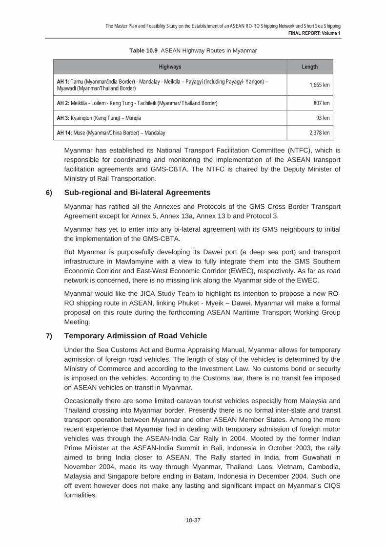
The Master Plan and Feasibility Study on the Establishment of an ASEAN RO-RO Shipping Network and Short Sea Shipping FINAL REPORT: Volume 1
10-37
Table 10.9 ASEAN Highway Routes in Myanmar
Highways Length
AH 1: Tamu (Myanmar/India Border) - Mandalay - Meiktila – Payagyi (including Payagyi- Yangon) – Myawadi (Myanmar/Thailand Border) 1,665 km
AH 2: Meiktila - Loilem - Keng Tung - Tachileik (Myanmar/ Thailand Border) 807 km
AH 3: Kyaington (Keng Tung) – Mongla 93 km
AH 14: Muse (Myanmar/China Border) – Mandalay 2,378 km
Myanmar has established its National Transport Facilitation Committee (NTFC), which is responsible for coordinating and monitoring the implementation of the ASEAN transport facilitation agreements and GMS-CBTA. The NTFC is chaired by the Deputy Minister of Ministry of Rail Transportation.
6) Sub-regional and Bi-lateral Agreements
Myanmar has ratified all the Annexes and Protocols of the GMS Cross Border Transport Agreement except for Annex 5, Annex 13a, Annex 13 b and Protocol 3.
Myanmar has yet to enter into any bi-lateral agreement with its GMS neighbours to initial the implementation of the GMS-CBTA.
But Myanmar is purposefully developing its Dawei port (a deep sea port) and transport infrastructure in Mawlamyine with a view to fully integrate them into the GMS Southern Economic Corridor and East-West Economic Corridor (EWEC), respectively. As far as road network is concerned, there is no missing link along the Myanmar side of the EWEC.
Myanmar would like the JICA Study Team to highlight its intention to propose a new RO-RO shipping route in ASEAN, linking Phuket - Myeik – Dawei. Myanmar will make a formal proposal on this route during the forthcoming ASEAN Maritime Transport Working Group Meeting.
7) Temporary Admission of Road Vehicle
Under the Sea Customs Act and Burma Appraising Manual, Myanmar allows for temporary admission of foreign road vehicles. The length of stay of the vehicles is determined by the Ministry of Commerce and according to the Investment Law. No customs bond or security is imposed on the vehicles. According to the Customs law, there is no transit fee imposed on ASEAN vehicles on transit in Myanmar.
Occasionally there are some limited caravan tourist vehicles especially from Malaysia and Thailand crossing into Myanmar border. Presently there is no formal inter-state and transit transport operation between Myanmar and other ASEAN Member States. Among the more recent experience that Myanmar had in dealing with temporary admission of foreign motor vehicles was through the ASEAN-India Car Rally in 2004. Mooted by the former Indian Prime Minister at the ASEAN-India Summit in Bali, Indonesia in October 2003, the rally aimed to bring India closer to ASEAN. The Rally started in India, from Guwahati in November 2004, made its way through Myanmar, Thailand, Laos, Vietnam, Cambodia, Malaysia and Singapore before ending in Batam, Indonesia in December 2004. Such one off event however does not make any lasting and significant impact on Myanmar’s CIQS formalities.

The Master Plan and Feasibility Study on the Establishment of an ASEAN RO-RO Shipping Network and Short Sea Shipping FINAL REPORT: Volume 1
10-38
Myanmar drove on the left hand side of the road until 1970 (i.e., with right hand drive vehicles). In December 1970, the military administration ordered that traffic to flow on the right hand side of the road. However, most passenger vehicles in Myanmar continue to be right hand drive since there has been no ban on the importation of new and second-hand right hand drive vehicles from Japan, Thailand, and Singapore. Usage of China and Russia-made left hand drive vehicles are common among the government officials and military. Today, both right and left hand drive vehicles are allowed on Myanmar’s roads. Recently, for safety reason, a new ruling came into effect in which new buses imported from foreign countries must be of left hand drive so that passengers may be alighted on the kerbside. This implies that in future foreign buses entering Myanmar will have to comply with the ruling.
Myanmar accepts and honors International Driving Permit (IDP). Myanmar also recognizes the domestic driving license of other ASEAN Member States. However, a temporary license fee of around USD20/pax is charged for non-international driving licenses.
Myanmar recognizes the inspection certificate issued by other ASEAN Member States as it is a signatory to the 1998 ASEAN Agreement on Recognition of Commercial Vehicle Inspection Certificate.
Foreign vehicles must purchase third party liability insurance upon arriving at Myanmar’s border crossings. There are facilities for purchasing the insurance at designated international check points in Myanmar.
Myanmar has a bi-lateral visa exemption agreement with Lao PDR but not with other Member States of ASEAN. Hence, citizens of these ASEAN Member States are required to secure entry visa when travelling to Myanmar. Beginning 1 May 2012, application of visas on arrival at the Yangon airport has been resumed. At its major sea and land ports, immigration facilities are open 24 hours. For other entry points, visitors are required to apply for special permits or visas prior to entering the country. Business visas can be granted for up to 70 days and extensions are allowed whereas personal visas are restricted to 28 days without further extensions. Multiple entry visas need to be applied through the Ministry of Foreign Affairs as Immigration Department is only able to issue single entry visa.
8) Concluding Remarks
The number of IMO conventions/protocols and UN road transport and customs conventions acceded/ratified by Myanmar is on the lower scale of the ASEAN list. This gives an indication that Myanmar has a relatively low level of legal and institutional readiness for international RO-RO shipping.
But Myanmar do enforce a number of ASEAN transport agreements, including the ASEAN Agreement on Recognition of Commercial Vehicle Inspection Certificate (1998), ASEAN Agreement on Recognition of Domestic Driving License (1985) and Ministerial Understanding on the Development of the ASEAN Highway Network Project (1999). There has being continuous effort to reform its domestic transport laws to be in line with international legislation. This include the amendments to its Merchant Shipping Act (1923) to be consistent with international conventions and the initiatives to open up its ship agency services to international competition by 2015 to meet the commitments made under the ASEAN Framework Agreement on Services.
The Master Plan and Feasibility Study on the Establishment of an ASEAN RO-RO Shipping Network and Short Sea Shipping FINAL REPORT: Volume 1
10-39
Myanmar shows strong intention to embark on new international RO-RO shipping route linking Phuket (Thailand) – Myeik (Myanmar) – Dawei (Myanmar). It is developing its Dawei port and transport infrastructure in Mawlamyine in order to physically integrate into the GMS transport system.
However, given the protracted impasses facing the implementation of the AFAFGIT and AFAFIST and CBTA, there is presently no regular transit and inter-state transport in Myanmar. Moreover, the country does not have any formal bi-lateral land transport agreement with its closest ASEAN neighbors (Thailand and Lao PDR). Generally Myanmar’s CIQ authorities do not have a lot of experience in dealing with temporary admission of road vehicles. Myanmar’s immigration law remains to be the most restrictive in ASEAN. Myanmar needs to intensify its legal and institutional reform process in order to be able to play a more significant role in intra-ASEAN RO-RO shipping.

The Master Plan and Feasibility Study on the Establishment of an ASEAN RO-RO Shipping Network and Short Sea Shipping FINAL REPORT: Volume 1
10-40
10.8 The Philippines 1) Administration
Created under the Executive Order (EO) No. 125, the Department of Transportation and Communications (DOTC) is the primary policy, planning, programming, coordinating, implementing and administrative national agency responsible for the development, promotion and regulation of the transportation and communications systems and services in the Philippines.
The Department has three Sectoral Offices and 15 Attached Agencies. The Sectoral Offices in charge of road transport are the Land Transportation Office (LTO), Land Transportation Franchising and Regulatory Board (LTFRB). On the maritime front, the Philippine Coast Guard (PCG) is primarily tasked with safeguarding life and property at sea, protecting marine resources and the environment, and assisting in the enforcement of maritime laws within the Philippines jurisdiction. The Office for Transportation Security (OTS) is in charge of transportation security for all sectoral offices and attached agencies. The Metro Rail Transit (MRT) Line 3 is the Project Management Office (PMO) of the Department. The Attached Agencies responsible for road transport are the Toll Regulatory Board (TRB) and Office of Transport Cooperatives (OTC). The key Attached Agencies responsible for maritime transport include the Maritime Industry Authority (MARINA), Philippine Ports Authority (PPA), The Cebu Ports Authority (CPA) and Philippine Merchant Marine Academy (PMMA).
2) Legal and Institutional Framework
The development of the maritime transport industry in the Philippines is guided by the Republic Act No. 9295 of 3 May 2004 entitled An Act Promoting the Development of Philippine Domestic Shipping, Shipbuilding, Ship Repair and Ship Breaking, Ordaining Reforms in Government Policies towards Shipping in the Philippines, and for Other Purposes (in short, ‘Domestic Shipping Development Act of 2004’).
To promote Filipino ownership of vessels and for the continued growth of the domestic merchant marine fleet, the Act grants qualified domestic ship operators the following investment incentives:
- Exemption from value-added tax on the importation and local purchase of passenger and/or cargo vessels of 150 tons and above, including engine and spare parts of said vessels. To avail of this incentive the vessels to be imported shall comply with the age limit requirements stipulated in the Act; and
- Exemption from value-added tax on the importation of life-saving equipment, safety and rescue equipment and communication, navigational safety equipment, etc.
As part of its cabotage arrangement, the Act does not permit foreign vessels to transport passengers or cargo between ports or places within the Philippine territorial waters, except upon the grant of Special Permit by the MARINA when no domestic vessel is available or suitable to provide the needed shipping service. No franchise, certificate or any other form of authorization for the carriage of cargo and/or passenger in the domestic trade are granted except to domestic ship operators. As a step towards deregulating the industry, domestic ship operators are given the right to fix their own passenger and/or cargo rates.
With respect to vessel safety, all vessels operated by domestic ship operators shall be in seaworthy condition, properly equipped with adequate life-saving communication, safety

The Master Plan and Feasibility Study on the Establishment of an ASEAN RO-RO Shipping Network and Short Sea Shipping FINAL REPORT: Volume 1
10-41
and other equipment, operated and maintained in accordance with the standards set by MARINA, and manned by duly licenses and competent vessel crew. Domestic ship operators are required to provide adequate insurance coverage for passenger and cargo on board their ships. All ships are acquired to be classed by a government recognized classification society on the date of acquisition prior to its operation in the domestic trade.
To promote the development of Philippine overseas shipping, Republic Act No. 9301 was enacted in July 2004, amending certain provisions of Republic Act No. 7471 entitled An Act to Promote the Development of Philippine Overseas Shipping and for Other Purposes. Under the amended act, Philippine shipping enterprises are exempted from payment of income tax on income derived from Philippine overseas shipping for a period of 10 years from the date of approval of the Act.
Prompted by the need to reduce inter-island transportation cost, the Philippine Government has been focussing on developing domestic RO-RO facilities and vessels over the past one decade. With the issuance of Executive Order No. 170 dated 22 January 2003, a new policy promoting the participation of and investment by the private sector in the development of the RO-RO terminal system (RRTS) was established. The coverage of the RRTS was later expanded through the issuance of Executive Order 170-A dated 9 June 2003.
Executive Order 170-B dated 19 September 2005 further enhanced the initiative to develop RO-RO facilities and vessels in the country. To widen the coverage of the nautical highway program and to entice greater private sector participation, the EO stipulated measures for conversion of private non-commercial ports into private commercial ports.
All port authorities, like the Philippine Ports Authority, Cebu Ports Authority, Regional Port Management Authority and other independent port authorities were ordered to allow and encourage the conversion of private non-commercial ports into private commercial ports under the RRTS network. Proximity to and direct competition with a public port shall not be a valid cause for non-approval of any private port conversion. The port authorities and MARINA were given the task to maintain an affordable level of RO-RO transport charges across the RRTS network.
3) Ship Registration
The Philippines aims to become a major shipping registry in the region and beyond. Mindful of the steady downtrend in the ships registered under bareboat chartering program and in the face of increasing competition from China, India, and Indonesia, the country has repositioned itself as a ‘flag-of-choice’. The country welcomes ships of any type, size and age to register there, provided the ship is class maintained by an international recognized classification society.
According to Memorandum Circular No. 182 of MARINA, a ship may be registered in the Philippines provided the company is accredited by the MARINA under its Memorandum Circular No. 181. The company must have a paid-up capital of Peso 7 million (US$160,920) for shipowning companies and Peso 10 million (US$229,885) for non-shipowning companies. The Chief Executive and Chief Operating Officer shall be citizens of the Philippines. Two principal officers shall have at least five years’ experience in ship management, shipping operations and/or chartering. In terms of incentives, under the Republic Acts No. 7471 and 7301, ships acquired through importation or ship’s spare parts used for the repair/overhauled of ship are exempted from import duties and taxes derived
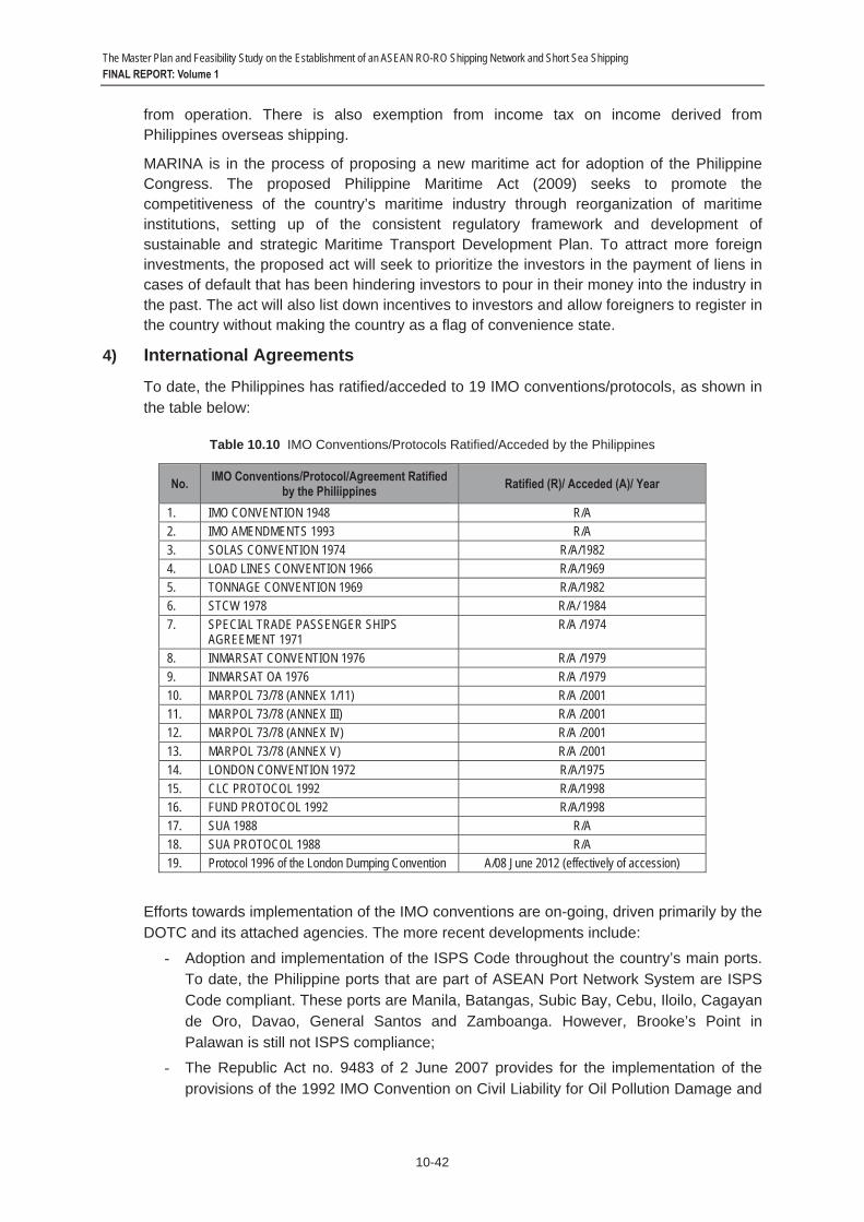
The Master Plan and Feasibility Study on the Establishment of an ASEAN RO-RO Shipping Network and Short Sea Shipping FINAL REPORT: Volume 1
10-42
from operation. There is also exemption from income tax on income derived from Philippines overseas shipping.
MARINA is in the process of proposing a new maritime act for adoption of the Philippine Congress. The proposed Philippine Maritime Act (2009) seeks to promote the competitiveness of the country’s maritime industry through reorganization of maritime institutions, setting up of the consistent regulatory framework and development of sustainable and strategic Maritime Transport Development Plan. To attract more foreign investments, the proposed act will seek to prioritize the investors in the payment of liens in cases of default that has been hindering investors to pour in their money into the industry in the past. The act will also list down incentives to investors and allow foreigners to register in the country without making the country as a flag of convenience state.
4) International Agreements
To date, the Philippines has ratified/acceded to 19 IMO conventions/protocols, as shown in the table below:
Table 10.10 IMO Conventions/Protocols Ratified/Acceded by the Philippines
No. IMO Conventions/Protocol/Agreement Ratified by the Philiippines Ratified (R)/ Acceded (A)/ Year
1. IMO CONVENTION 1948 R/A 2. IMO AMENDMENTS 1993 R/A3. SOLAS CONVENTION 1974 R/A/19824. LOAD LINES CONVENTION 1966 R/A/1969 5. TONNAGE CONVENTION 1969 R/A/1982 6. STCW 1978 R/A/ 1984 7. SPECIAL TRADE PASSENGER SHIPS
AGREEMENT 1971 R/A /1974
8. INMARSAT CONVENTION 1976 R/A /1979 9. INMARSAT OA 1976 R/A /1979 10. MARPOL 73/78 (ANNEX 1/11) R/A /2001 11. MARPOL 73/78 (ANNEX III) R/A /2001 12. MARPOL 73/78 (ANNEX IV) R/A /2001 13. MARPOL 73/78 (ANNEX V) R/A /2001 14. LONDON CONVENTION 1972 R/A/1975 15. CLC PROTOCOL 1992 R/A/1998 16. FUND PROTOCOL 1992 R/A/199817. SUA 1988 R/A18. SUA PROTOCOL 1988 R/A19. Protocol 1996 of the London Dumping Convention A/08 June 2012 (effectively of accession)
Efforts towards implementation of the IMO conventions are on-going, driven primarily by the DOTC and its attached agencies. The more recent developments include:
- Adoption and implementation of the ISPS Code throughout the country’s main ports. To date, the Philippine ports that are part of ASEAN Port Network System are ISPS Code compliant. These ports are Manila, Batangas, Subic Bay, Cebu, Iloilo, Cagayan de Oro, Davao, General Santos and Zamboanga. However, Brooke’s Point in Palawan is still not ISPS compliance;
- The Republic Act no. 9483 of 2 June 2007 provides for the implementation of the provisions of the 1992 IMO Convention on Civil Liability for Oil Pollution Damage and
The Master Plan and Feasibility Study on the Establishment of an ASEAN RO-RO Shipping Network and Short Sea Shipping FINAL REPORT: Volume 1
10-43
the 1992 IMO Convention on the Establishment of an International Fund for Compensation for Oil Pollution Damage;
- The Administrative Order No. 242 of 13 October 2008 authorized the Secretary of the DOTC to implement the voluntary IMO Member State Audit Scheme; and
- As a party to the 1993 MoU on Port State Control in the Asia-Pacific Region (Tokyo MoU), the Philippine Coast Guard conducted close to 1500 individual inspections in 2011.
To make the country a registry-of-choice among ship owners or ship management companies, the Philippines is considering to accede to the UN Arrest Convention of 1952, among others. The Convention provides 22 grounds by which a ship can be arrested by port control authorities of a certain country. By ratifying and adopting the convention, ships flying Philippine flags can invoke their rights under the convention when arrested by port control authorities in other countries.
Philippine road traffic regulations are conformed to international standards as it is a party to the 1949 Geneva Convention on Road Traffic (which was later replaced by the 1968 Vienna Convention on Road Traffic)
5) Regional Agreements
The Philippines is a party to the following transport agreements: - The ASEAN Framework Agreement on the Facilitation of Goods in Transit
(AFAFGIT), 1998 - The ASEAN Framework Agreements on Multimodal Transport (AFAMT), 2005
- The ASEAN Framework Agreement on Facilitation of Inter-State Transport (AFAFIST), 2008
- The ASEAN Agreement on Recognition of Commercial Vehicle Inspection Certificate, 1998
- The ASEAN Agreement on Recognition of Domestic Driving License, 1985 - Ministerial Understanding on the Development of the ASEAN Highway Network
Project, 1999 - MoU on Cooperation Relating to Marine Casualty and Marine Incident Safety
Investigations, 2009
The Philippines has ratified the AFAFGIT and AFAMT but not AFAFSIT.
The Philippines has established the National Competent Body for Multimodal Transport to implement the 2005 ASEAN Framework Agreement on Multimodal Transport. It has also established its NTTCC to implement the 1998 ASEAN Framework Agreement on the Facilitation of Goods in Transit. Executive Order No. 786 of 9 March 2009 gave the Secretary of Transportation and Communications greater leeway in selecting agencies and instrumentalities which can ably assist him in coordinating the national transit transport.
The Philippines has not implemented the 1985 Agreement on the Recognition of Domestic Driving Licenses Issued by ASEAN Countries. It recognises only International Driving Permit/ License. Holders of such license are allowed to drive in the Philippines for a period of 90 days, after which they are required to convert the license to a local license without the need to sit for a domestic driving test. The Philippine officials are expected to have

The Master Plan and Feasibility Study on the Establishment of an ASEAN RO-RO Shipping Network and Short Sea Shipping FINAL REPORT: Volume 1
10-44
difficulties understanding the driving licenses issued by the Indonesian authorities since they are printed in Indonesian language.
Unlike its many ASEAN counterparts, the Philippines has not entered any bi-lateral road transport agreements with other ASEAN Member States. Though it is a signatory to the BIMP-EAGA MoU on Cross-Border Movement of Commercial Buses and Coaches (2007) and MoU on Transit and Inter-State Transport of Goods (2009), there is presently no Filipino transport operator operating under the MoUs.
The Pan-Philippine Highway, also known as the Maharlika Highway is part of the ASEAN Highway Network (AH26) (which is also part of the Asian Highway Network). The Philippines designated AH26 as the transit transport route under the AFAFGIT. AH26 comprises of the following routes. The length of AH26 is approximately 3,460 km, stretching from Laoag City in Luzon passing through the Visayas Islands (Samar & Leyte) down to Zamboanga City in Mindanao. No road in Palawan has been designated as part of the ASEAN Highway Network.
Laoag – Tuguegarao – Manila – Legazpi – Matnog – ferry – Allen – Tacloban (Ormoc – ferry – Cebu) – Liloan – ferry – Surigao – Davao (Cagayan de Oro) – General Santos – Zamboanga
As of June 2011, over 87 percent of the AH26 were of Class III standard, 0.2 percent Class II, 7.7 per cent Class I and 4.8 per cent Primary. In terms of pavement type, 58 percent were asphalt, 41 percent concrete and one percent gravel.
The high percentage of Class III roads suggests that most of the designated routes in the Philippines will not be able to accommodate the types of vehicle prescribed under the AFAFGIT. Transport officials also pointed out during the Country Survey that the Cagayan de Oro-Davao portion of the AH 26 was not designed and built to accommodate articulated trucks as indicated by the frequent road accidents involving such vehicles on the highway.
Some 450 route markers and directional signs that are of international standards are currently being installed along AH26 following the issuance of Department of Public Works and Highways Order No.15 in March 2009. The installation work is expected to be completed by end 2013. (Source: Country Survey and Maria Catalina E. Cabral, Status of Asian Highway, Philippines, September 2011; http://www.unescap.org/ttdw/ common/TIS/AH/files/wgm4/Countries/PPT/Philippines.pdf)
6) Temporary Admission of Road Vehicle
There is no specific law in the Philippine that govern the temporary admission of private road vehicles. The closest rules and regulations may be found under Section 105 of Tariff and Customs Code of the Philippines, as amended (TCCP); TCCP provisions and Customs regulations on warehousing; various laws and regulations on the entry of imported goods to free ports and special economic zones; and Omnibus Investment Code. However, these acts are mostly deal with temporary importation of vehicles to be used by those in government service or for foreign diplomats; or, Department of National Defense under Government to Government Agreements such as the Visiting Forces Agreement.
The Philippines is not a party to the 1956 Customs Convention on the Temporary Importation of Commercial Road Vehicles. Under the Philippine Customs regulations, motor vehicle, including trailers and parts are dutiable items. Vehicles that are brought in by RO-RO ships are treated as import goods and therefore subject to a relatively long process of customs clearance and paper works. The Import Authority Permit is available only in the

The Master Plan and Feasibility Study on the Establishment of an ASEAN RO-RO Shipping Network and Short Sea Shipping FINAL REPORT: Volume 1
10-45
Philippines and cannot be issued by an embassy or consulate office. The issuing body is the Philippine Bureau of Import Service of the Department of Trade and Industry. Right-hand-drive vehicles are strictly not permitted to enter the country. In addition, vehicles that are five years old or older are not allowed to be brought in.
The Bureau of Immigration does not give any special visa/pass for professional driver of foreign vehicles. Foreign drivers are subject to the standard immigration rule of the country. Similarly, the standard quarantine rules are applied to the cargo carried by RO-RO ships.
7) Concluding Remarks
The Philippines has been purposefully developing its maritime legal infrastructure with the view to transform the country from a seafarer-supplying country into a major shipping industry hub.
Industry sources suggest that the Republic Nautical Highway initiative has led to improvement in domestic passenger and cargo flows, with significant savings in both cost and in transit time.
While the Philippines’ domestic RO-RO shipping industry is among the most established and progressive in ASEAN, there is no indication that the country is ready to venture into international RO-RO shipping operation in the foreseeable future. So far there is no Philippine flagged RO-RO ship plying the ASEAN waters. This is in spite of the various legislative reform initiatives to make the country a registry-of-choice among ship owners or ship management companies.
Unlike the CLMV countries and some parts of the IMT-GT and BIMP-EAGA members which are connected by land and are fairly familiar with transit and inter-state transport facilitation brought about either by bi-lateral or sub-regional arrangements, the Philippines, being an island nation, has no such experience. It has no practical experience in issuing land transport permit and compulsory vehicle insurance to foreign operators engaging in cross-border operation; and in dealing with mutual recognition of driving licenses, vehicle registration certificates and temporary admission of vehicles. Its existing legal and institutional frameworks are hardly conducive to receiving foreign RO-RO ships and foreign vehicles on-board of such ships.
The customs and immigration regimes required for effective facilitation of entry and exit of foreign RO-RO ships and vehicles are not yet in place. It enforces restrictive rules on recognition of foreign driving licenses and prohibits entering of right-hand-drive vehicles. All these may explain why Filipino transport officials are often of the view that chassis RO-RO shipping operation may be more viable than the conventional RO-RO shipping operation.
The Master Plan and Feasibility Study on the Establishment of an ASEAN RO-RO Shipping Network and Short Sea Shipping FINAL REPORT: Volume 1
10-46
10.9 Singapore 1) Administration
The Ministry of Transport oversees the development and regulation of the civil aviation and air transport, maritime and ports and land transport sectors. Its main focus is to formulate policies and facilitate outcomes in the transport arena. The day-to-day operations are handled by its four statutory boards, namely the Civil Aviation Authority of Singapore, Land Transport Authority, Maritime and Port Authority of Singapore and Public Transport Council.
The Civil Aviation Authority of Singapore is responsible for the development of the air hub and aviation industry in Singapore as a whole as well as the provision of air navigation services. The Land Transport Authority is responsible for spearheading the land transport developments in Singapore. The Maritime and Port Authority of Singapore’s mission is to develop Singapore as a premier global hub port and international maritime centre, and to advance and safeguard Singapore’s strategic maritime interests. The Public Transport Council is an independent body that regulates bus services, public transport fares and ticket payment services.
2) Legal and Institutional Framework
The following Table shows the list of domestic rules and regulations governing the transport logistics services in Singapore.

The Master Plan and Feasibility Study on the Establishment of an ASEAN RO-RO Shipping Network and Short Sea Shipping FINAL REPORT: Volume 1
10-47
Table 10.11 Laws and Regulations Related to Transport Logistics Services Sector in Singapore
No. Sub-Sectors Relevant Laws and Regulations
1. Maritime cargo handling services - Maritime and Port Authority of Singapore Act, Cap. 170A- Business Registration Act, Cap. 32 - Companies Act, Cap. 50 - Limited Liability Partnerships Act, Cap. 163A - Limited Partnerships Act - Customs Act Cap. 70:
a) Customs (Authorised Piers and Places for Import by Sea) Regulations b) Customs (Authorised Piers and Places for Transhipment, Export and Transit
by Sea) Regulations - Regulation of Import and Exports Act Cap. 272A
2. Storage & warehousing services - Maritime and Port Authority of Singapore Act, Cap. 170A- Business Registration Act, Cap. 32 - Companies Act, Cap. 50 - Limited Liability Partnerships Act, Cap. 163A - Limited Partnerships Act
3. Freight transport agency services - Business Registration Act, Cap. 32- Companies Act, Cap. 50 - Limited Liability Partnerships Act, Cap. 163A - Limited Partnerships Act - Customs Act Cap. 70 - Regulation of Imports and Exports Act Cap. 272A
4. Other auxiliary services - Business Registration Act, Cap. 32- Companies Act, Cap. 50 - Limited Liability Partnerships Act, Cap. 163A - Limited Partnerships Act - Customs Act Cap. 70 - Regulation of Imports and Exports Act Cap. 272A
5. Customs clearance services - Business Registration Act, Cap. 32- Companies Act, Cap. 50 - Limited Liability Partnerships Act, Cap. 163A - Limited Partnerships Act - Customs Act Cap. 70 - Regulation of Imports and Exports Act
6. International Freight Transportation excluding Cabotage
- Business Registration Act, Cap. 32- Companies Act, Cap. 50 - Limited Liability Partnerships Act, Cap. 163A - Limited Partnerships Act
7. International road freight transport services
- Business Registration Act, Cap. 32- Companies Act, Cap. 50 - Limited Liability Partnerships Act, Cap. 163A - Limited Partnerships Act - Road Traffic Act Cap. 276
Source: Adopted from the ASEAN Secretariat; http://www.asean.org/logisticsservices.htm
3) Ship Registration
The Singapore Registry of Ships is administered by the Maritime and Port Authority of Singapore. As an open registry, it ranks among the top ten largest registries in the world with over 3,850 registered vessels. The registry adopts a "quality flag" strategy and offers maritime and related companies a range of incentive schemes to grow and develop their businesses in Singapore. The two key incentive schemes are the Maritime Sector Incentive scheme and Maritime Cluster Fund. The former offers tax exemption to qualified international shipping companies; tax concessions for up to 5 years for ship or container leasing companies, funds, business trusts or partnerships; a concessionary tax rate of 10% on the incremental income derived from the provision of shipping-related support services; and withholding tax exemption on interest payable on loans obtained from foreign lenders to finance the purchase or construction of ships. The latter includes financial and technical support for manpower development.

The Master Plan and Feasibility Study on the Establishment of an ASEAN RO-RO Shipping Network and Short Sea Shipping FINAL REPORT: Volume 1
10-48
There is no special requirement or incentives for registration of RO-RO ship. The same registration requirements and incentives apply to any ship type. Singapore currently has no plan to introduce international RO-RO shipping services over the medium to long term.
4) International Agreements
Among the ASEAN Member States, Singapore has acceded to/ratified the most number of IMO conventions (31 in all), as follows:
- IMO Convention 48 - IMO amendments 91 - IMO amendments 93
- SOLAS Convention 74 - SOLAS Protocol 78
- SOLAS Protocol 88 - LOAD LINES Convention 66
- LOAD LINES Protocol 88 - TONNAGE Convention 69
- COLREG Convention 72 - STCW Convention 78
- SAR Convention 79 - IMSO Convention 76
- INMARSAT OA 76 - INMARSAT amendments 94
- INMARSAT amendments 98 - FACILITATION Convention 65
- MARPOL 73/78 (Annex I/II) - MARPOL 73/78 (Annex III)
- MARPOL 73/78 (Annex IV) - MARPOL 73/78 (Annex V)
- MARPOL Protocol 97 (Annex VI) - CLC Protocol 76
- CLC Protocol 92 - FUND Protocol 92
- LLMC Convention 76 - SUA Convention 88 - OPRC Convention 90
- OPRC/HNS 2000 - BUNKERS CONVENTION 01
- ANTI FOULING 01
Singapore Port is ISPS Code compliant. In line with the SOLAS Regulation XI-2/3 and XI-2/7, the Maritime and Port Authority of Singapore (MPA) sets security levels and ensures

The Master Plan and Feasibility Study on the Establishment of an ASEAN RO-RO Shipping Network and Short Sea Shipping FINAL REPORT: Volume 1
10-49
that the current security level information is made known to ships and their respective flag states.
Singapore is a party to the 1949 UN Convention on Road Traffic (Geneva Convention 1949), which was translated into Singapore law via the Road Traffic (International Circulation) Rules. Singapore is also a party to and 1956 Customs Convention on the Temporary Importation of Commercial Road Vehicles.
The General Agreement for Tariffs and Trade (GATT) through Article V also obligates contracting parties to preserve freedom of transit. Singapore became a contracting party in 1973.
5) Regional Agreements
At the ASEAN level, Singapore is a party to the following transport agreements:
- The ASEAN Framework Agreement on the Facilitation of Goods in Transit (AFAFGIT), 1998
- The ASEAN Framework Agreements on Multimodal Transport (AFAMT), 2005 - The ASEAN Framework Agreement on Facilitation of Inter-State Transport
(AFAFIST), 2008 - The ASEAN Agreement on Recognition of Commercial Vehicle Inspection Certificate,
1998 - The ASEAN Agreement on Recognition of Domestic Driving License, 1985
- Ministerial Understanding on the Development of the ASEAN Highway Network Project, 1999
- MoU on Cooperation Relating to Marine Casualty and Marine Incident Safety Investigations, 2009
Singapore Port is part of the ASEAN Port Network system.
The expressway networks in Singapore and Malaysia are connected via the Ayer Rajah Expressway (connects with the Second Link Expressway in Malaysia) and Bukit Timah Expressway (connects with the Skudai Highway via Johor–Singapore Causeway).
Bi-lateral Agreements
Singapore has entered bilateral maritime transport agreements with Myanmar and Vietnam. The relevant articles of the agreements are listed below:
Myanmar Agreement 1998 Article 4B – Non-discriminatory treatment Article 5 – Equal status as other countries, no less favourable Article 8 – Standardised crew identity documents
Article 9.3 – Crew members able to go ashore during the period of stay of their vessels in ports but subject to host country’s rules and regulations
Article 12 – Expedite and simplify customs and formalities at ports
Myanmar Addendum to Agreement 1998 Article 1 – Cooperation in shipping and shipping ancillary services and set up companies to promote shipping and trade
The Master Plan and Feasibility Study on the Establishment of an ASEAN RO-RO Shipping Network and Short Sea Shipping FINAL REPORT: Volume 1
10-50
Article 2 – To expedite applications for setting up of companies and assist in finding solutions.
Vietnam Agreement 1992 Article 2.2 – Both contracting parties open to investments Article 4 – Non-discriminatory treatment
Article 5 – Awarded most-favoured nation status applied to customs, port dues, access and use of port facilities. Article 8 –Standardised crew identity documents
Article 9.3 – Crew members able to go ashore during the period of stay of their vessels in ports but subject to host country’s rules and regulations Article 12 – Expedite and simplify customs and formalities at ports
6) CIQS Formalities on International RO-RO Ships
There is no foreign RO-RO ship calling at Singapore Port. If any, such ship would subject to the normal CIQS formalities.
There is no Customs import permit requirement for passengers’ own vehicles and personal effects driven or carried out of the RO-RO ship calling at Singapore Port. Similarly, there is no Customs export permit requirement for passengers’ own vehicles and personal effects driven or carried into the RO-RO ship leaving Singapore Port, except for exports of dutiable, controlled and strategic goods. However, a Customs permit is required if passengers bring in dutiable, controlled or commercial goods from the RO-RO ship into Singapore. The services of freight forwarders or declaring agents may be engaged to declare such permits. Freight forwarders and declaring agents are required to register with Singapore Customs prior to declaring Customs permits via TradeNet®, Singapore’s national single window.
The shipping agent/master of the RO-RO vessel is required to submit crew and passengers manifests in advance of its arrival and departure from Singapore. For immigration clearance, passengers and crew must carry a valid travel document (passport, etc) and are subject to the prevailing immigration entry requirements, including having obtained a valid Singapore visa prior to arrival in Singapore (where applicable), an In-Principle Approval Letter issued by the Singapore Immigration & Checkpoints Authority (for crew), and submit a duly completed disembarkation/embarkation card upon arrival and departure respectively.
7) Temporary Admission of Road Vehicle
Singapore allows temporary admission road vehicles to its territory. The relevant laws are the Customs Act, Customs Duties (Exemption) Order, Goods and Services Tax Act and Goods and Services Tax (Imports Relief) Order. Singapore’s law does not specify how long the vehicle can be in the country. No customs duty is imposed on the vehicle and no customs guarantee is required. Tax is payable only if the vehicle is sold, disposed of or transferred locally.
Foreign drivers must observe local traffic rules, including fastening of seat belts, avoiding the bus lane during certain hours, and using mobile phones while driving only with a hands-free device.
Foreigners visiting Singapore may drive with their foreign license for up to 12 months each time they enter into the country. Singapore Traffic Police recognizes driving licenses issued by ASEAN Member States. It is not necessary for the license holders to convert their

The Master Plan and Feasibility Study on the Establishment of an ASEAN RO-RO Shipping Network and Short Sea Shipping FINAL REPORT: Volume 1
10-51
licenses to Singapore driving licenses if they are not staying in Singapore for more than a year. For a foreign driving license that is not written in English language, an International Driving Permit or an official translation in English language is required.
Foreign registered vehicles entering Singapore must have a valid insurance coverage for the period of the vehicles stay in Singapore; a valid road tax and an Autopass Card. Autopass Card is a non-transferable stored-value smart card that is used for paying toll charges, Electronic Road Pricing (ERP) (an electronic toll collection scheme) fees and car park charges for car parks that use the cash card system. The card costs SGD 10 (about USD8) and is sold at the main primary clearance and immigration booths at Singapore checkpoints. It is valid for five years.
Singapore does not allow left hand drive vehicles from being imported for personal local registration, but temporary usage by tourists of left hand drive vehicles is allowed.
All Singapore-registered vehicles are required to have their petrol tanks at least three quarters full before departing from Singapore. This ruling has been in place since 1991. It is part of Singapore's policy to moderate vehicle usage and reduce traffic congestion. Since January 2012, the three-quarter tank rule has also applied to compressed natural gas (CNG) fuel supply tanks of CNG vehicles and petrol-CNG vehicles.
Motor vehicles leaving Singapore must pay toll charges at both ends of the Causeway and the Second Link.
Cross-border traffic between Singapore and Malaysia are generally governed by the 1949 UN Convention on Road Traffic (Geneva Convention 1949). Both Singapore and Malaysia are parties to the Convention, which facilitates cross-border movement of vehicles between member countries by specifying the minimum standards relating to vehicle construction and use which vehicles must meet while in the host country in order that they not be denied entry. The standards are spelt out in general terms, including such requirements as that the vehicle must be in good working order and safe mechanical condition so as not to endanger the driver, other occupants of the vehicle or other road users, and that the vehicle should be used in a manner so as not to cause damage to public or private property, and in adherence to traffic rules and regulations in the host country.
Singapore issues the ASEAN Goods Vehicle Permits and ASEAN Public Service Vehicle Permits to qualified Malaysian goods vehicle and public service vehicle entering into Singapore. Operation of these vehicles is governed by the provisions of the Road Traffic (International Circulation) Rules as well as the Terms and Conditions on the Permits themselves (see section under Malaysia for more information on Singapore-Malaysia road transport arrangements).
All foreign-registered vehicles (except Malaysia-registered) must buy mandatory insurance coverage at the immigration checkpoint in Singapore. Premiums collected are channeled into a special purpose insurance pool known as the Special Risks Pool.
8) Concluding Remarks
Being one of the most developed maritime hubs in the World, Singapore has an established legal and institutional framework to facilitate international RO-RO shipping operation. Singapore has a relatively liberal regulatory regime to deal with temporary admission of road vehicles, for example, no customs duty is imposed on foreign vehicles and no customs guarantee is required. Though being a right hand drive nation, Singapore allows temporary
The Master Plan and Feasibility Study on the Establishment of an ASEAN RO-RO Shipping Network and Short Sea Shipping FINAL REPORT: Volume 1
10-52
usage by tourists of left hand drive vehicles. Singapore’s CIQS authorities have considerable experience in dealing with cross-border movement of road vehicles, particularly those from/to Malaysia and Thailand. Though developing a RO-RO shipping industry is not a national priority for now, Singapore’s legal and institutional framework has a high level of readiness to deal with intra-ASEAN RO-RO shipping operation.

The Master Plan and Feasibility Study on the Establishment of an ASEAN RO-RO Shipping Network and Short Sea Shipping FINAL REPORT: Volume 1
10-53
10.10 Thailand 1) Administration
The Ministry of Transport is responsible for the planning, development, management and regulation of the transport sector. The Ministry of Transport is comprised of a number of Government Administrations and State Enterprises. The Marine Department, Department of Land Transport, Department of Civil Aviation, Department of Highways, Department of Rural Roads and Office of Transport Policy and Traffic are among the Government Administrations under the Ministry. The State Enterprises include State Railway of Thailand, Port Authority of Thailand, Mass Rapid Transit Authority of Thailand, Expressway and Rapid Transit Authority of Thailand and Bangkok Mass Transit Authority.
2) Legal and Institutional Framework
Under the Thai Vessels Act B.E.2481 (as amended by the Act B.E.2540), Thai domestic shipping is restricted to Thai vessels (at least 70% of Thai equity).
The Port Authority of Thailand Act B.E.2494 (1951) as amended by the Act B.E.2543 (2000) stipulates the functions of the Port Authority of Thailand (PAT), which includes management, monitoring and control of Bangkok Port, Laem Chabang Port and other designated ports.
The following are the relevant laws governing the transport logistics sector in Thailand.
Table 10.12 Laws and Regulations Related to Transport Logistics Services Sector in Thailand
No. Sub-Sectors Relevant Laws and Regulations
1. Maritime cargo handling services Port Authority of Thailand Act B.E.2494 (1951)
2. Storage and warehousing services Foreign Business Act B.E. 2542 (1999)
3. Freight transport agency services Foreign Business Act B.E. 2542 (1999)
4. Other auxiliary services - Customs Act B.E. 2469 (1926)- Foreign Business Act B.E. 2542 (1999)
5. Customs clearance services Customs Act B.E. 2469 (1926)
6. International freight transportation excluding Cabotage Navigation in Thai Water Acts B.E. 2456 (1913)
7. International rail freight transport services - Railway of Thailand Act B.E. 2494 (1951) - Organization of Railway and Highway Act B.E.2464 (1921)
8. International road freight transport services Land Transport Act B.E. 2522 (1979)
Source: Adopted from the ASEAN Secretariat; http://www.asean.org/logisticsservices.htm
3) Ship Registration
Thailand welcomes both the foreign and domestic shipping operators/owners to fly it flag, subject to the following conditions:
- The operator must be a juristic person incorporated under Thai law with at least 51% of Thai equity (Thai Vessels Act B.E.2481 (as amended by the Act B.E.2540)) and must register as a maritime transport operator at the Maritime Department (Mercantile Marine Promotion Act B.E.2521); and
The Master Plan and Feasibility Study on the Establishment of an ASEAN RO-RO Shipping Network and Short Sea Shipping FINAL REPORT: Volume 1
10-54
- Operation of such ships must comply with the safety and marine environmental requirements prescribe under the Navigation in Thai Waters Act B.E. 2456 (as amended by the Act B.E.2540).
So far no RO-RO shipping company plying international routes has registered under the Thai registry. The registry does not offer any special incentive to attract registration of RO-RO ships.
4) International Agreements
Thailand has acceded to/ratified 13 IMO Conventions/Protocols, as follows. - IMO Convention 48
- IMO amendments 91 - IMO amendments 93
- SOLAS Convention 74 - LOAD LINES Convention 66
- TONNAGE Convention 69 - COLREG Convention 72
- STCW Convention 78 - IMSO Convention 76
- INMARSAT OA 76 - FACILITATION Convention 65
- MARPOL 73/78 (Annex I/II) - OPRC Convention 90
Thailand is a party to the following international land transport Conventions:
- 1949 Geneva Convention on Road Traffic
- 1968 Vienna Convention on Road Traffic - 1968 Convention on Road Signs and Signals
5) Regional Agreements
Thailand is a party to the following ASEAN transport agreements: - The ASEAN Framework Agreement on the Facilitation of Goods in Transit
(AFAFGIT), 1998 - The ASEAN Framework Agreements on Multimodal Transport (AFAMT), 2005 - The ASEAN Framework Agreement on Facilitation of Inter-State Transport
(AFAFIST), 2008 - The ASEAN Agreement on Recognition of Commercial Vehicle Inspection Certificate,
1998 - The ASEAN Agreement on Recognition of Domestic Driving License, 1985
- Ministerial Understanding on the Development of the ASEAN Highway Network Project, 1999
- MoU on Cooperation Relating to Marine Casualty and Marine Incident Safety Investigations, 2009
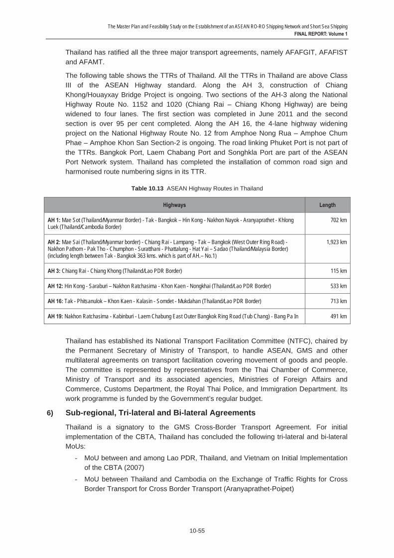
The Master Plan and Feasibility Study on the Establishment of an ASEAN RO-RO Shipping Network and Short Sea Shipping FINAL REPORT: Volume 1
10-55
Thailand has ratified all the three major transport agreements, namely AFAFGIT, AFAFIST and AFAMT.
The following table shows the TTRs of Thailand. All the TTRs in Thailand are above Class III of the ASEAN Highway standard. Along the AH 3, construction of Chiang Khong/Houayxay Bridge Project is ongoing. Two sections of the AH-3 along the National Highway Route No. 1152 and 1020 (Chiang Rai – Chiang Khong Highway) are being widened to four lanes. The first section was completed in June 2011 and the second section is over 95 per cent completed. Along the AH 16, the 4-lane highway widening project on the National Highway Route No. 12 from Amphoe Nong Rua – Amphoe Chum Phae – Amphoe Khon San Section-2 is ongoing. The road linking Phuket Port is not part of the TTRs. Bangkok Port, Laem Chabang Port and Songhkla Port are part of the ASEAN Port Network system. Thailand has completed the installation of common road sign and harmonised route numbering signs in its TTR.
Table 10.13 ASEAN Highway Routes in Thailand
Highways Length
AH 1: Mae Sot (Thailand/Myanmar Border) - Tak - Bangkok – Hin Kong - Nakhon Nayok - Aranyaprathet - Khlong Luek (Thailand/Cambodia Border)
702 km
AH 2: Mae Sai (Thailand/Myanmar border) - Chiang Rai - Lampang - Tak – Bangkok (West Outer Ring Road) - Nakhon Pathom - Pak Tho - Chumphon - Suratthani - Phattalung - Hat Yai – Sadao (Thailand/Malaysia Border) (including length between Tak - Bangkok 363 kms. which is part of AH.– No.1)
1,923 km
AH 3: Chiang Rai - Chiang Khong (Thailand/Lao PDR Border) 115 km
AH 12: Hin Kong - Saraburi – Nakhon Ratchasima - Khon Kaen - Nongkhai (Thailand/Lao PDR Border) 533 km
AH 16: Tak - Phitsanulok – Khon Kaen - Kalasin - Somdet - Mukdahan (Thailand/Lao PDR Border) 713 km
AH 19: Nakhon Ratchasima - Kabinburi - Laem Chabung East Outer Bangkok Ring Road (Tub Chang) - Bang Pa In 491 km
Thailand has established its National Transport Facilitation Committee (NTFC), chaired by the Permanent Secretary of Ministry of Transport, to handle ASEAN, GMS and other multilateral agreements on transport facilitation covering movement of goods and people. The committee is represented by representatives from the Thai Chamber of Commerce, Ministry of Transport and its associated agencies, Ministries of Foreign Affairs and Commerce, Customs Department, the Royal Thai Police, and Immigration Department. Its work programme is funded by the Government’s regular budget.
6) Sub-regional, Tri-lateral and Bi-lateral Agreements
Thailand is a signatory to the GMS Cross-Border Transport Agreement. For initial implementation of the CBTA, Thailand has concluded the following tri-lateral and bi-lateral MoUs:
- MoU between and among Lao PDR, Thailand, and Vietnam on Initial Implementation of the CBTA (2007)
- MoU between Thailand and Cambodia on the Exchange of Traffic Rights for Cross Border Transport for Cross Border Transport (Aranyaprathet-Poipet)

The Master Plan and Feasibility Study on the Establishment of an ASEAN RO-RO Shipping Network and Short Sea Shipping FINAL REPORT: Volume 1
10-56
- MoU on the Initial Implementation (Aranyaprathet-Poipet)
- MoU on the Initial Implementation (Mukdahan-Savannakhet)
Thailand is a party to the Arrangement between and among Lao PDR, Thailand, and Vietnam on the Operation of the Tourism Road Transport (2007). Thailand has also signed the following bi-lateral agreements/MOUs with Lao PDR and with Malaysia:
- Agreement Between the Government of the Kingdom of Thailand and the Government of the Lao People’s Democratic Republic on Road Transport (1999)
- Subsidiary Agreement Specifying Road Transport Arrangement between the Government of Thailand and the Government of the Lao PDR (2001)
- MoU between Thailand and Malaysia on the Movement in Transit of Perishable Goods by Road from Thailand through Malaysia to Singapore (1979)
The extent of the MoUs implementation is indicated by the number of licenses issued by the Department of Land Transport of Thailand. According to the 2010 records of the Department of Land Transport, in the year 2007, Thailand issued 59 licences for cross-border bus services involving 177 vehicles; 310 truck licences (involving 9,761 vehicles) for the cross-border operation between Thailand and Lao PDR and 3 truck licences (79 vehicles) for operation under the MoU between Thailand and Malaysia on the Movement in Transit of Perishable Goods by Road from Thailand through Malaysia to Singapore.
Thailand, Lao PDR and Vietnam started to exchange traffic rights for the East-West Economic Corridor in June 2009. Work is on-going for implementation of customs transit systems along the Corridor. However, implementation of the MoU on the Initial Implementation for Aranyaprathet-Poipet was delayed due to political situation (see the sections under Lao PDR, Cambodia, Vietnam and Malaysia for more information on the implementation status of the MoUs).
7) Temporary Admission of Road Vehicle
Under the Customs Tariff Decree (Heading 3, Part 4), Thailand allows temporary admission of road vehicles free of import duty or tax. The vehicles are allowed to be in the country for a period of up to two months, with possible extension of up to six months. Any further extension will need the approval from the Customs Department. Approval will normally be granted only in exceptional circumstances such as a broken engine, car accident, etc. The time-limit may be extended to more than six months but not exceeding eight months from the date of admission.
The vehicle owners/operators are required to pay a security in the form of a bank guarantee or cash amounting to 120 per cent of tax and plus another two per cent of tax per month. The security will be forfeited if the vehicle not exported within the time indicated on the temporary import papers.
The documents required for temporary admission include temporary import declaration form, the vehicle's registration certificate, a passport or identification card of the vehicle's owner, an application form for the temporary import of the vehicle, a proforma invoice or invoice, certificate of legal Entity, re-export contract and if the vehicle is to be driven by someone other than the owner and proof of Power of Attorney. All fittings and accessories such as stereo system, CD players must be declared at the time of admission. Temporary admission papers such as ATA Carnet cannot be used to replace national Customs document.
The Master Plan and Feasibility Study on the Establishment of an ASEAN RO-RO Shipping Network and Short Sea Shipping FINAL REPORT: Volume 1
10-57
Vehicles owners or operators must submit the temporary import declaration form and relevant documents at the port of entry/border checkpoint in Thailand. Once the form and relevant documents have been checked the vehicle owners or operators must deposit the bank guarantee with the Cashier Division of the Thai Customs Department. This will follows by customs inspection of the vehicle. Once this is done, the vehicle owners or operators will receive one copy of the form which they must keep to return to Customs when leaving the country.
Thailand is a signatory to the Istanbul Convention since January 2007. It acceded to Annex A and B1 of the Convention.
Thailand also recognizes both the private and commercial domestic driving licenses issues by other ASEAN Member States under the 1985 Agreement on the Recognition of Domestic Driving Licenses Issued by ASEAN Countries. License holders may only drive the category of vehicle for which their license is valid.
Being a signatory to the 1949 Geneva Convention on Road Traffic and 1968 Vienna Convention on Road Traffic, Thailand accepts International Driver's License/Permit (IDL/IDP).
Thai Immigration Department requires foreigners entering Thailand by road vehicles to fill in and present the Thai arrival/departure card and a completed manifest (when there are accompanying passengers).
Thailand does not recognize insurance of other ASEAN Member States. Vehicle operators/owners are required to purchase third party liability insurance at the Thai side of border crossing. The cost of the insurance policy may vary according to vehicle type, engine size and duration of cover.
Thailand is a left hand drive country. But its law does not prohibit right hand drive vehicles to drive on its roads. Technically and legally it has no problem receiving vehicles from Malaysia, Singapore and Indonesia which are also left hand drive countries. But Thailand is surrounded by right hand drive neighbors like Cambodia, Lao PDR and Myanmar, which means switching of traffic from one side to the other at borders is necessary. To facilitate such changeover, traffic lights or signposts are installed at the following locations:
- Friendship Bridge between Thailand and Lao PDR
- Second Friendship Bridge between Thailand and Lao PDR - Mae Sot Friendship Bridge between Thailand and Myanmar - Poipet between Thailand and Cambodia
8) Concluding Remarks
The land transportation system of Thailand is quite well connected with those in Lao PDR, Cambodia, Vietnam (via Lao PDR and Cambodia), Malaysia, and to a certain extent, with Myanmar. Thailand’s CIQS agencies are familiar with inter-state and transit transport facilitation requirements and processes brought about the country’s active participation in a number of bi-lateral and tri-lateral land transport MoUs with its neighboring countries. It has a competitive road transport industry with many years of cross-border operation experience. For example, Thai transport operator began to deliver perishable goods by road from Thailand to Singapore via Malaysia since late 1970s or early 1980s under the Thailand-Malaysia MoU on the Movement in Transit of Perishable Goods by Road from Thailand through Malaysia to Singapore (1979). Thai bus and truck operators are said to be a
The Master Plan and Feasibility Study on the Establishment of an ASEAN RO-RO Shipping Network and Short Sea Shipping FINAL REPORT: Volume 1
10-58
dominate force in the Thailand-Lao PDR cross-border transport business. Thailand is a left hand drive country but it welcomes right hand drive vehicles. It recognizes all classes of driving licenses and commercial vehicles inspection certificates issued by other ASEAN Member States. Thailand has a thriving tourism industry. All these are important ingredients for developing a viable RO-RO shipping industry in Thailand and beyond. Further streamlining of its CIQ and transit transport formalities through adoption of international transport and customs conventions may be necessary. As of now, Thailand has ratified and implemented only a relatively small number of IMO conventions and UN road transport and customs conventions.
The Master Plan and Feasibility Study on the Establishment of an ASEAN RO-RO Shipping Network and Short Sea Shipping FINAL REPORT: Volume 1
10-59
10.11 Vietnam 1) Administration
The Ministry of Transport is responsible for the planning, development, management and regulation of the country’s transport sector, covering road, railway, inland waterway, maritime and civil aviation transport. Its power is derived from the Decree No. 178/2007/ND-CP dated 3 December 2007.
The Ministry accords high priority in developing seaport infrastructure facilities; increasing the shipping capacity of Vietnamese fleets; and transferring and applying maritime scientific and technological advances. The development of the maritime transport sector is guided by two master plans, one on sea port development and another on ocean shipping development.
There are five specialized agencies under the Ministry of Transport, as follows:
- Vietnam Road Administration - Vietnam Inland Waterways Administration
- Vietnam National Maritime Bureau - Vietnam Register
- Transport Construction Quality Control and Management Bureau
Vinalines is the main shipping company in the country. It is a state-owned enterprise under the Ministry of Transport. Ports in Vietnam fall under the jurisdiction of the Vietnam National Maritime Bureau of the Ministry of Transport.
In recent years, the Government of Vietnam has been putting in place various regulatory measures to improve the financial sustainability, competitiveness and governance of the state-owned enterprises of the Ministry.
2) Legal and Institutional Framework
The Vietnam Maritime Code 2005 (entered into force in 2006) provides the legal framework for management of the maritime sector, covering seagoing vessels, crew, seaports, marine navigable channels, ocean shipping, marine navigation safety, marine navigation security, prevention of environmental pollution and other activities related to the use of seagoing vessels for economic, cultural, social, sport, public service and scientific research purposes. All Vietnamese organizations and individuals and foreign organizations and individuals involved in maritime shipping activities in Vietnam are governed by the Code. The Maritime Code 2005 represents a major revision of the 1990 Maritime Code of Vietnam.
The Law on Road Traffic 2008 (effective in 2009) sets the legal framework for road transportation, road infrastructure facilities, road traffic, road users and state management of road traffic. Prior to this, the land transport sector in Vietnam was governed by the Road Code of Vietnam 2001.

The Master Plan and Feasibility Study on the Establishment of an ASEAN RO-RO Shipping Network and Short Sea Shipping FINAL REPORT: Volume 1
10-60
The following laws and regulations governing the transport logistics sector in Vietnam.
Table 10.14 Laws and Regulations Related to Transport Logistics Services Sector in Vietnam
No. Sub-Sectors Relevant Laws and Regulations
1. Maritime cargo handling services Maritime Code, 2005.Trade Law, 2005. Decree No.140/2007/ND-CP.
2. Storage & warehousing services Law on Trade, 2005.Decree No.140/2007/ND-CP
3. Freight transport agency services Maritime Code, 2005.Law on Trade, 2005. Decree No.140/2007/ND-CP.
4. Other auxiliary services Maritime Code, 2005.Law on Trade, 2005. Decree No.140/2007/ND-CP.
5. Customs clearance services Law on Custom, 2001 and Amended, 2005 Decree No. 140/2007/ND-CP
6. International Freight Transportation excluding Cabotage
Maritime Code, 2005.Law on Trade, 2005. Decree No.140/2007/ND-CP.
7. International rail freight transport services Law on Railway, 2005.Decree No. 140/2007/ND-CP
8. International road freight transport services Law on Road traffic, 2008.Decree No. 140/2007/ND-CP
Source: Adopted from the ASEAN Secretariat; http://www.asean.org/logisticsservices.htm
3) Cabotage
Article 7 of the Vietnam Maritime Code 2005 reserves coastal trades for Vietnamese-flag ships. Vietnamese seagoing vessels enjoy priority to conduct domestic carriage of cargoes, passengers and luggage.
However, when Vietnamese seagoing vessels are incapable of domestic carriage, foreign seagoing vessels may participate in domestic carriage. This may take place under the following circumstances:
- Carrying extra-long and extra-heavy cargoes or other kinds of cargoes by seagoing vessels exclusively used for this purpose;
- Preventing, controlling, remedying the consequences of, natural disasters, epidemics or rendering emergency relief; and
- Transporting passengers and luggage from tourist passenger vessels to shore and vice versa.
4) Ship Registration
Vietnam Register is responsible for ship registration in Vietnam. The country encourages all Vietnamese and foreign entities to develop its fleets, seaport infrastructure facilities and carry out other maritime shipping activities in Vietnam.
To register under the Vietnam National Register of Ships, a seagoing vessel must satisfy the following requirements as stipulated under Article 16 of the Vietnam Maritime Code 2005:

The Master Plan and Feasibility Study on the Establishment of an ASEAN RO-RO Shipping Network and Short Sea Shipping FINAL REPORT: Volume 1
10-61
- Legal paper proving ownership of the vessel;
- Certificates showing the tonnage and class of the vessel; - Having a name that is approved by the Vietnam Registry of Shipping;
- Certificates of suspension or deletion of registration if the vessel is registered abroad; - The ship-owner must have its head office, branches or representative offices in
Vietnam; and - Used foreign seagoing vessels applying for first-time registration or re-registration in
Vietnam must comply with the age limit set by the Government.
There are around 800 vessels registered under the Registry with less than 5% of them are foreign vessels. Vietnam Register does not offer any special incentive to attract registration of RO-RO vessels. Vietnam Register charges a low registration fee. This in itself is an incentive for vessels to register in Vietnam.
Vietnam does not accord high priority to developing its RO-RO shipping industry. There is no such plan in its Master Plan for Ocean Shipping. But Vietnam is monitoring the market conditions and has not ruled out the possibility of participating in intra-ASEAN RO-RO shipping.
In the mid-2000s, Vietnam used to have a RO-RO ship plying its domestic routes. However the service was suspended due to poor market demand. There were limited berthing facilities to facilitate the RO-RO shipping operation then. For tourism development, Vinalines is now looking into the option of deploying the RO-RO ship to service the northern part of Vietnam and Hainan Island (China).
5) International Agreements
Vietnam has acceded to/ratified 19 IMO Conventions/Protocols, as follows:
- IMO Convention 48 - IMO amendments 93
- SOLAS Convention 74 - SOLAS Protocol 78
- SOLAS Protocol 88 - LOAD LINES Convention 66
- LOAD LINES Protocol 88 - TONNAGE Convention 69
- COLREG Convention 72 - STCW Convention 78 - IMSO Convention 76
- INMARSAT OA 76 - INMARSAT amendments 98
- FACILITATION Convention 65 - MARPOL 73/78 (Annex I/II)
- CLC Protocol 92
The Master Plan and Feasibility Study on the Establishment of an ASEAN RO-RO Shipping Network and Short Sea Shipping FINAL REPORT: Volume 1
10-62
- SUA Convention 88
- SUA Protocol 88 - BUNKERS CONVENTION 01
The MARPOL 73/78 and SOLAS have been translated into Vietnamese language, among others.
Vietnam has acceded to the International Convention on the Simplification and Harmonization of Customs Procedures (Kyoto Convention). Vietnam is not a party to any of the major UN road traffic and transport facilitation conventions. However, Vietnam honors the International Driving Permits issued under the UN Road Traffic Conventions. The road signs along its major highways are complied with international standards. Nevertheless, Vietnam is studying the possibility of acceding to the Vienna Convention on Road Signs and may accede to the Convention by next year.
6) Regional Agreements
Vietnam is a party to the following ASEAN transport agreements: - The ASEAN Framework Agreement on the Facilitation of Goods in Transit
(AFAFGIT), 1998 - The ASEAN Framework Agreements on Multimodal Transport (AFAMT), 2005
- The ASEAN Framework Agreement on Facilitation of Inter-State Transport (AFAFIST), 2008
- The ASEAN Agreement on Recognition of Commercial Vehicle Inspection Certificate, 1998
- The ASEAN Agreement on Recognition of Domestic Driving License, 1985 - Ministerial Understanding on the Development of the ASEAN Highway Network
Project, 1999 - MoU on Cooperation Relating to Marine Casualty and Marine Incident Safety
Investigations, 2009
Vietnam has ratified the AFAFGIT and AFAMT but not the AFAFIST. Vietnam has established its NTTCC to coordinate and monitor the implementation of the ASEAN and GMS transport agreements. The NTTCC is chaired by the Vice Minister of Transport.
Saigon, Haiphong, Danang, and Cailan are part of ASEAN Port Network system. Besides promoting these ports, Vietnam has been also developing Van Phong, a transhipment port in Khanh Hoa in central Vietnam and Cai Mep, a deep sea port in Vung Tau to serve southern Vietnam.
Vietnam’s TTRs under the AFAFGIT are shown in the table below. Some of these routes are also an integral part if the ASEAN Highway Network. Vietnam has eight AH routes with a total length of 4,200 km. To date most of the AH routes in Vietnam have been upgraded to at least class 3 standard. Vietnam has installed common road signs and route numbering system on all its TTRs.

The Master Plan and Feasibility Study on the Establishment of an ASEAN RO-RO Shipping Network and Short Sea ShippingFINAL REPORT: Volume 1
10-63
Table 10.15 ASEAN Highway Routes in Vietnam
Highways Length
AH 1: Moc Bai (Vietnam/Cambodia Border) - An Suong (Ho Chi Minh City) 99 km
AH 1: Dong Ha – Da Nang/Tien Sa 197 km
AH 15: Keo Nua (Vietnam/Lao PDR Border) - Bai Vot - Vinh – Cua Lo 123 km
AH 16: Lao Bao (Vietnam/Lao PDR Border) - Dong Ha 83 km
AH 17: Dong Nai - Vung Tau 75 km
7) Sub-regional, Tri-lateral and Bi-lateral Agreements
Vietnam is a signatory to the GMS Cross-Border Transport Agreement. For initialimplementation of the CBTA, Vietnam, Lao PDR and Thailand concluded the MoU on InitialImplementation of the CBTA in 2007. The MoU allows for operation of cross border roadtransport of goods and people along the East-West Economic Corridor at the Lao Bao-Dansavanh and at the Savannakhet-Mukdahan border crossing points. Cross-bordertransport traffic under the MoU has been on the rise especially for the Vietnam-Lao PDRsector.
Under the MoU, personal effects carried by people not engaged in cross-border transportoperations are exempted from customs duties and taxes. It also exempts sealed goodsincluding sealed containers in international transit from routine physical customs inspectionat the border and customs escorts in the national territory. The goods in transit are alsoexempted from customs duties and taxes.
Single-window inspection and single stop inspection have been adopted at the Lao Bao-Dansavanh border crossing. Single Window Inspection has been implemented at Hakou-Lao Cai border crossing.
Vietnam, Lao PDR and Thailand mutually recognize each other’s vehicle registrationcertificate, registration plate and inspection certificate under the MoU.
The allowed period for the temporary admission of vehicle without payment of import dutiesand taxes is 30 days. The quantitative quota is 500 vehicles for each country. Customsguarantee in form of security is still required. In that case, a designated organization suchas national forwarders’ association may give a guarantee.
To promote tourism, the Arrangement between and among Lao PDR, Thailand, andVietnam on the Operation of the Tourism Road Transport was signed in 2007. The keyfeatures of the Arrangement are similar to the MoU between and among Lao PDR,Thailand, and Vietnam on Initial Implementation of the CBTA (2007).
Under the Vietnam-Lao PDR Road Transport Agreement, vehicles of the two countries areallowed to cross 15 designated border-pairs. The agreement applies to both non-commercial and commercial vehicles.
Under the Vietnam-Cambodia Road Transport Agreement, vehicles of the two countries areallowed to cross seven designated border-pairs. The quantitative quota is 40 commercial

The Master Plan and Feasibility Study on the Establishment of an ASEAN RO-RO Shipping Network and Short Sea ShippingFINAL REPORT: Volume 1
10-64
vehicles for each country for the initial implementation period with the flexibility ofincreasing to 150 and 300 at later dates.
Vietnam and Lao PDR have a bi-lateral agreement on making Vung Ang a transit port forthe latter. Cua Lo Port and Danang Port in Vietnam are also serve as transit ports for LaoPDR (see sections under Lao PDR and Thailand for more information on theimplementation status of the tri-lateral and bi-lateral MoUs).
8) Concluding Remarks
Vietnam has made commendable progress in reforming its legal system to support itseconomic transition from planning to market. The 2005 Vietnam Maritime Code and theLaw on Road Traffic 2008 provide a sound basis for the efficient operation of transport subsectors. Generally both laws are consistent with international conventions, guiding thedevelopment of the transport sector towards global integration. Vietnam has madeencouraging progress in connecting its land and maritime transport sectors with that of theASEAN and GMS through implementation of the relevant ASEAN transport agreements(e.g., mutual recognition of driving licenses, ASEAN Highway MoU, etc.) and initialimplementation of the CBTA-related tri-lateral and bi-lateral arrangements. To provideadded impetus to the regional and sub-regional integration process as well as to establish asound legal and institutional framework for its future participation in intra-ASEAN RO-ROshipping, Vietnam should consider stepping up its effort in adopting and enforcing moreinternational transport facilitation conventions. Presently Vietnam is not a party to most ofthe major UN road transport and transport facilitation conventions.

Annexes

ANNEX TO CHAPTER 1
A1-1
Annex 1.1
JICA-ASEAN FIRST REGIONAL WORKSHOP ON THE MASTER PLAN AND FEASIBILITY STUDY ON THE ESTABLISHMENT OF
AN ASEAN RO-RO SHIPPING NETWORK AND SHORT SEA SHIPPING
24-25 July 2012, Manila, Philippines
HIGHLIGHTS OF DISCUSSIONS
1. The Workshop was attended by participants from all ASEAN Member States (except Singapore), Japan International Cooperation Agency (JICA), BIMP-EAGA Secretariat, ALMEC Corporation, and the ASEAN Secretariat.
2. The Workshop was officially opened by Hon. Nicasio Conti, Officer-in-charge, Maritime Industry Authority of the Philippines. Mr. Shimura Akira, Deputy Director General, JICA also delivered his Opening Remarks.
3. Mr. H.R. Vitasa served as the moderator for the Workshop.
Session 1: Lessons Learned from Other RO-RO Experiences
4. The participants noted some lessons from the experiences of EU and Northeast Asia on the development of international RO-RO shipping, and of archipelagic countries like Japan, the Philippines and Indonesia on the development of domestic RO-RO shipping. Such experiences vary in terms of history, implementation, and level of success.
5. The participants also noted the common factors and best practices leading to successful development of RO-RO shipping, among others, are the following:
- Creating market demand for RO-RO shipping services (in terms of cargo and passengers);
- Favorable geographic conditions; - Strong support by the governments and private sector; - Initial provision of incentives and subsidies (e.g., fuel, taxes, financing,
reduced port fees, etc.) until the routes become commercially viable; - Adequate infrastructure; - Effective intermodal transport such as land transport (e.g., trucks and buses)
to support RO-RO shipping; - Effective marketing and promotion strategy; and - Profitable operations.
6. The participants were of the view that feasibility of RO-RO shipping should be viewed in terms of the whole integrated RO-RO transport system, including shipping services, port operations, logistics and intermodal interface/connectivity. This will be further examined during the more detailed analysis of the selected shortlisted RO-RO routes.

A1-2
Session 2: Legal and Institutional Framework for RO-RO Shipping Development
7. Based on a legal and institutional survey conducted in all the ASEAN countries, it was noted that an initial assessment of the legal and institutional readiness for RO-RO shipping development was made in terms of their comparative levels of accession/ ratification/ enforcement of international, regional, subregional and bilateral agreements on maritime and land transport, and the complexity of their cross-border formalities.
8. The participants shared the view that it is necessary to set the basic legal and institutional agenda for ASEAN RO-RO shipping. In this regard, it was widely recognised that the ASEAN transport facilitation agreements covering goods in transit (AFAFGIT), inter-state transport (AFAFIST) and multimodal transport (AFAMT) provide the relevant guiding and implementing principles to address among others the key institutional bottlenecks and constraints in ASEAN RO-RO shipping. Successful experiences and best practices of bilateral, trilateral and subregional agreements (such as those under the BIMP-EAGA, IMT-GT, GMS, SOSEK-MALINDO cooperation mechanisms) are valuable to be replicated in more international entry points. In the overall, a practical and harmonised legal agenda for ASEAN RO-RO shipping should underscore and converge into the following operational aspects:
• Temporary admission of road vehicles(No customs security and No tax on goods in transit)
• Mutual recognition of driving licenses • Mutual recognition of vehicle inspection certificates • Mutual recognition of insurance policies • Mutual recognition of vehicle registrations • Validity of cross-border vehicles permits are standardised • Single-window inspection & single stop inspection • Exemption from routine physical customs inspection at the border & no customs
escorts in the national territory • Frequent traveler facility
9. The participants agreed that further detailed study of the selected routes is needed to look into institutional requirements, including possible implementation agreements/MOUs between interested countries, as a first step, to advance the Master Plan on ASEAN Connectivity (MPAC)’s initiative on the Establishment of an ASEAN Ro-Ro shipping Network and Short Sea Shipping. The resulting agreement/MOU may also have to include defining the core institutional and coordination mechanisms, roles/responsibilities of the interested countries in promoting/marketing the routes, etc.
Session 3: ASEAN RO-RO Candidate Routes
10. The participants noted that the 8 candidate routes surveyed for RO-RO shipping development were found to have varying levels of viability, from mature to uncertain. Assessment of their viability was mainly based on demand, physical conditions, and regulatory environment.
11. The participants also noted that the Muara-Labuan route, the only existing international RO-RO shipping service in the study area, is an example of good practice. Despite birth pains and initial teething problems, it was developed into a viable route. The participants further noted that on the other hand, the Belawan-Penang pilot RO-RO shipping project is an example of a failed attempt at route development. Both these experiences provide practical lessons for consideration in the development of the other RO-RO routes.
A1-3
Session 4: How to Promote ASEAN RO-RO Shipping Development
12. JICA Study Team presented the RO-RO shipping development opportunities and selection criteria and process for the selection of priority routes. Based on the results of comprehensive selection process, JICA Study Team recommended the selection of the following priority routes: Dumai-Malacca route, Belawan-Penang-Phuket route, and General Santos-Bitung route. The selection reasons including the proposed RO-RO ship types and sizes were also presented by JICA Study Team. In addition, the JICA Study Team made presentations on RO-RO terminal development issues and basic directions of improvement, recommendations to improve institutional coordination, and proposed measures to promote a favorable business environment for RO-RO shipping of the priority routes.
13. Recognising the importance of the establishment of an ASEAN RO-RO Network by 2015 which is mentioned in the MPAC and the Brunei Action Plan/ASEAN Strategic Transport Plan, the participants shared the following views:
• Commercial viability as well as the hard and soft infrastructures, such as port facilities, access road, and institutional arrangements including exemption of import duties to transit transport would be prerequisites to establish sustainable RO-RO shipping network;
• Further cooperation would be needed in order to put the preconditions into place, not only in priority route countries but also in other potential routes so that a common image of ASEAN RO-RO services would be envisaged in the future; and
• The selection of priority routes is one of the joint steps for the establishment of an ASEAN RO-RO shipping network.
14. The participants confirmed the following criteria for the selection of priority routes:
a) There must be certain level of existing traffic and part of them would be diverted to RO-RO shipping route;
b) RO-RO shipping service can be introduced by 2015 as a sustainable transport system, consisting of vessel, terminal, access road and others; and
c) Route countries would commit to provide efficient CIQS services and an attractive regulatory framework to support RO-RO shipping operators’ investment planning and marketing.
15. In addition to the above criteria, the participants agreed that priority routes would provide good lesson for realising RO-RO shipping network in ASEAN in terms of certain level of replicability for other ASEAN Member States.
16. After extensive discussion, the participants agreed to select Dumai-Malacca route, Belawan-Penang-Phuket route, and General Santos-Bitung route as the priority routes. The participants noted that JICA Study Team will conduct further analysis on the selected routes.
17. The progress of the Study will be reported to the 24th ASEAN Maritime Transport Working Group Meeting to be held in October 2012 in Myanmar.

A1-4
Session 5: Field Survey and Planning Works for Priority Routes
18. The participants were briefed on the schedule and activities of the second field survey including the convening of the Second Regional Workshop on the Master Plan and Feasibility Study on the Establishment of an ASEAN RO-RO Shipping Network and Short Sea Shipping in December 2012 in Jakarta, Indonesia.
19. The national focal points of Indonesia, the Philippines, Malaysia and Thailand were requested to provide necessary support to JICA Study Team particularly on the arrangements of the stakeholder interview survey, port traffic survey, workshop among local shipping and maritime industries, workshop/meeting between RO-RO shipping related stakeholders, and workshop/meeting for drafting a route-wide MOU where transport and customs official will attend.
Closing Session
20. ASEAN Member States and the ASEAN Secretariat thanked JICA for organising the Workshop.
21. Mr. Ken Kumazawa, Leader of JICA Study Team, delivered his Closing Remarks. Hon. Ildefonso T. Patdu Jr., Assistant Secretary, Department of Transportation and Communications of the Philippines officially closed the Workshop.
A1-5
Annex 1.2
JICA-ASEAN SECOND REGIONAL WORKSHOP ON THE MASTER PLAN AND FEASIBILITY STUDY ON THE ESTABLISHMENT OF
AN ASEAN RO-RO SHIPPING NETWORK AND SHORT SEA SHIPPING
6 December 2012, Jakarta, Indonesia
HIGHLIGHTS OF DISCUSSION
1. The Workshop was attended by participants from Indonesia, Malaysia, the Philippines, Thailand, Japan International Cooperation Agency (JICA), JICA Study Team, the Mission of Japan to ASEAN and the ASEAN Secretariat.
2. The Workshop was officially opened by Mr. Leon Muhamad, Secretary General, Ministry of Transportation of Indonesia. Mr. Kawakami Taiji, Executive Technical Advisor to the Director General, JICA also delivered his Opening Remarks.
3. Mr Honorio R. Vitasa and Mr. Adolf R. Tambunan served as the moderators for the Workshop.
Session 1: How to Develop Priority Routes
4. The Study Team presented international RO-RO shipping experiences in Europe, Northeast Asia and an example of successful RO-RO shipping practice in ASEAN, between Muara (Brunei Darussalam) and Labuan (Malaysia). It was noted that factors leading to successful RO-RO shipping operations among others are the existence of stable demand (both passengers and vehicles), acceptance of various kinds of transit vehicles, smooth immigration and customs procedures, sufficient parking spaces and bilateral MOU between two participating countries to attract RO-RO operators. An example of suspended RO-RO shipping operation was also presented, underlining problems of infrastructure and regulation.
5. The Study Team noted that 3 priority routes, namely: Dumai-Malacca route, Belawan-Penang-Phuket route, and General Santos-Bitung, were selected from 8 (eight) RO-RO shipping candidate routes after conducting survey based on the criteria of potential demand, available infrastructure, and institutional preparedness. The Study Team presented the result of evaluation on the 3 priority routes, as follows:
a. Priority Route 1: Dumai – Malacca Both sides of the route welcomed the planned RO-RO services, as it would bring benefits to their local economies including possibilities of expanding tourism industries. International RO-RO terminals are proposed to be built both in Dumai and Malacca, particularly in Malacca where a new terminal will be attached to the proposed cruise terminal jetty.
b. Priority Route 2: Belawan – Penang – Phuket The stakeholders of both sides are more optimistic about the RO-RO shipping service due to bigger market demand today and convertible traffic from NCV and container ship trade and the absence of existing passenger shipping. The three existing ports at Belawan, Penang and Phuket will be re-organized to accommodate RO-RO terminal requirements. There are also some issues of institutional arrangements that need to be overcome, such as: the designation of international RO-RO terminal at Butterworth/Penang Port, customs regulation in
A1-6
Indonesia, immigration regulations at Penang and recognition of driver’s license and vehicle registration particularly of Thai vehicles.
c. Priority Route: General Santos – Bitung The development of this route would reduce by as much half the shipping distance between Hong Kong and Bitung via Jakarta/Surabaya. There is only small convertible traffic, but large inducible traffic along and beyond the corridor. Some issues needs to be addressed are: the need to upgrade Port of Bitung to be an international port, customs regulations in both sides, and vehicle recognition in the Philippines.
6. In order to realize a financially viable and sustainable RORO operations several actions must be undertaken by the authorities concerned and at different levels of government.
7. The participants expressed their appreciation for the work done by the Study Team in assessing the potential markets and the existing issues among the routes. The local government representatives gave an update on the current situation on their respective initiatives to realize the proposed RORO routes.
Session 2: How to Make it Happen
Financial Plan of Priority Route Development
8. The Study Team presented the summary of financial internal rate of return (FIRR) for each selected route for 20 years (2015 to 2034) based on demand forecasts, operation plan and ship procurement cost and assumptions of shipping tariff. The results of the FIRR evaluation show that Belawan – Penang – Phuket is the most profitable route, due to high cargo volume and efficient operation. Dumai – Malacca route’s profitability is lower, but still rated as fair, due to high initial cost of purchasing 2 ships. The Bitung - General Santos route is the least profitable, as a result of small volume of passenger / cargo on likely acceptable fare tariff.
9. An alternative to increase the profitability is by purchasing second hand ships, which would be very relevant to the Bitung – General Santos route, which would not be viable unless a second-hand vessel is used and/or it receives operational subsidy.
10. In relation to the ship procurement cost and viability discussion, Japanese Mission, JICA, and Indonesia MOT shared information including their recognition on recent status and issues regarding the idea of possible cooperation on ship procurement loan, which has been under consideration, noting a proceeding example of public ship loan cooperation in Philippines, at the same time also for the reference of the other member states.
Promoting a Favorable Business Environment for RO-RO Shipping
11. The Study Team noted that successful RO-RO shipping development is supported by two co-dependent factors, namely sustainable RO-RO shipping routes and adequate investment in RO-RO shipping services and facilities. Common factors leading to favourable market conditions for sustainable RO-RO shipping routes are (i) rising growth in world, regional and national economies, (ii) sufficient suitable cargo and stable demand, (iii) complementary industry across the routes, (iv) adequate connections with the hinterlands; and (v) sufficient passenger traffic (especially for ROPAX). Physical and technical infrastructure, including port access roads, highways network, railway, trucks, and telecommunications, are also major important factors to develop an effective multimodal transport network and maintain the comparative advantages of RO-RO shipping, i.e. efficiency and speedy loading and unloading process.

A1-7
12. To enable profitable and sustainable shipping operations, the following measures can be taken to address financial concerns:
a. Provide incentives for RO-RO shipping development, especially on pioneering routes, such as investment incentives, permits, licenses, access to cheaper sources of vessels and capital goods, access to specialized financing schemes, financial subsidies, concessional port charges and fees and operational subsidies (e.g., fuel, etc.)
b. Adopt competitive RO-RO shipping tariff structure c. Explore possible common tariff structure at partner ports d. Encourage Joint Venture and Public Private Partnership schemes in investments
in shipping and port facilities 13. The participants expressed their appreciation for the presentations made on the
profitability scenarios and the needed inter-governmental and inter-sectoral coordination to ensure profitable and sustainable RORO operations. They noted, however, that the profitability picture is not very attractive for the private sector, hence, it would need government subsidy, in one form or another. It was suggested that some other financing schemes should be explored on a commercial basis and evaluate what would be the financial indices for each option.
Regional Institutional Framework and Corridor-wide MOU
14. The Study Team noted that two main institutional arrangements are required for a successful and sustainable international RO-RO operation in ASEAN:
a. Policy coordination and institutional harmonization within ASEAN ASEAN formulated a number of transport facilitation initiatives such as AFAFGIT, AFAFIST, and AFAMT. However, despite the signing of these agreements by Member States, some protocols, especially Protocols 2, 6 and 7 of the AFAFGIT, have yet to be concluded or ratified. The Study team also recommended solutions to address common legal and institutional issues for ASEAN RO-RO shipping development.
b. Route-wide Coordination among Route Connecting countries Notwithstanding the presence of a number of ASEAN Framework Agreements, the development of RO-RO shipping route can be hastened through a bilateral agreement between participating countries. This is also in line with the ASEAN-X principle, wherein a number of ASEAN Member States may enter into an agreement following or adopting a general ASEAN Agreement. In line with this, the Study Team presented a draft MOU between countries involved in ASEAN RO-RO Shipping Network with the following salient features: • Priority is given to shipping companies or ship operators registered in
either of the Participating Parties; • It is the responsibility of the vessel operator to plan for an efficient and
profitable frequency of service and vessel schedule, in consultation and coordination with the concerned maritime and port authorities of the Participating Parties;
• Compliance with operational, technical, safety and security standards is compulsory.
15. The Study Team also presented some of its findings on the current Customs policies and practices, and how these practices can be aligned with the primary objective of RORO transport, i.e., seamless transport.
16. The participants thanked the Study Team for their analysis on the required institutional framework for the successful operation of ASEAN RORO Network and for the preparation
A1-8
of the draft MOU. They noted that the cooperation of many government agencies and private sector players would be needed to discuss and work towards addressing the various legal and institutional measures proposed for developing the RO-RO shipping routes. There needs to be convergence of these efforts. However, they would still need to study the proposed MOU some more as coordination and consolidation of opinions and positions on the RO-RO recommendations among stakeholders has to be done first at the domestic level, then raise it to the appropriate regional level, then to STOM. They also suggested to look more closely into the success factors in the Muara-Labuan RO-RO route. The participants also proposed subsidy sharing between among partner countries in the development of the three (3) RO-RO routes.
17. The participants further suggested that the implementation recommendations be raised to the IMT-GT and BIMP-EAGA. Maybe a special committee within these regional bodies can be organized to look at the recommendations and submit their own recommendations to ASEAN. There is a high expectation among the countries in implementing the RO-RO shipping services. Given that the MTWG meets only every six months, there is a need to have a coordinating body to continue moving the project forward.
18. The JICA representative informed that the Study results will be presented in the next MTWG meeting. JICA will consider whatever will be the requests from the MTWG, for further action after completion of the study to support the implementation of the RO-RO project. Japanese Mission to ASEAN will continue to dialogue with the countries through not only MTWG but also Japan-ACCC related meetings, if necessary, while noting the need and their concern on how to involve other concerned agencies, for example the Customs agencies, in these dialogues.
19. The Moderator suggested to sharpen the study recommendations on a per route basis. Additional comments from the countries may be submitted to the Study Team by the end of December 2012.
20. ASEAN Member States and the ASEAN Secretariat thanked JICA for organizing the Workshop.
21. Mr. Ken Kumazawa, Leader of JICA Study Team, delivered his Closing Remarks. Mr. Adolf R. Tambunan, Director for Sea Transport, Ministry of Transportation of Indonesia officially closed the Workshop.

ANNEX TO CHAPTER 2
A2-1
Annex 2.1 Agreement between Korea and China on Multimodal Transport
AGREEMENT BETWEEN THE GOVERNMENT OF THE REPUBLIC OF KOREA AND THE GOVERNMENT OF THE PEOPLE’S REPUBLIC OF CHINA ON SEA-LAND
INTERMODAL FREIGHT VEHICLE TRANSPORTATION
The Government of the Republic of Korea and the Government of the People’s Republic of China (hereinafter referred to as "the Parties"), Recognizing that sea-land intermodal freight vehicle transportation is an important transport mode to meet the increasing demand of trade between the two countries, Desiring to enhance logistics efficiency and transportation facilitation and to promote the development of the economies of and trade between the two countries, and Based on the principles of reciprocity and mutual benefit, Have agreed as follows:
Article 1 Definitions For the purpose of this Agreement: a)"Sea-land intermodal freight vehicle transportation" means transportation by
freight vehicles of the two countries between the ports, zones or along transportation routes agreed upon by the Parties after being shipped by vessels.
b) "Sea-land intermodal freight vehicle transportation" includes methods such as trailer chassis transportation and tractor trailer transportation and so forth.
Article 2 Phased-in Implementation 1.Sea-land intermodal freight vehicle transportation shall be implemented on a
phased-in basis. Trailer chassis transportation without a tractor shall be in the first phase, and trailer chassis transportation with a tractor shall be in the second.
2. Specific implementing arrangements for each phase will be set out in the protocols to this Agreement.
3. The first phase shall be implemented after this Agreement and its protocol enter into force. Based on the result of the first phase, the Parties shall endeavor to move to the second phase.
Article 3 Operation Permit 1. The Parties shall mutually allow transportation vehicles of the other country that
satisfy the requirements of this Agreement and its protocols to undertake sea-land intermodal freight vehicle transportation under this Agreement.
2.Ports, zones or transportation routes and the number of transportation permits subject to this Agreement shall be set out by the Parties in the protocols to this Agreement.

A2-2
Article 4 Implementation Method Sea-land intermodal freight vehicle transportation shall be implemented through the Korea-China sea-land intermodal freight vehicle transportation permit system, and the specifics shall be set out in the protocols to this Agreement.
Article 5 International Distinguishing Signs and Safety Standards 1. Transportation vehicles of the two countries shall use their respective international
transportation distinguishing signs. The distinguishing sign for each country is as follows:
a) for the Republic of Korea: ROK; b) for the People’s Republic of China: CHN. 2. The Parties shall mutually recognize the vehicle registration numbers issued by
the vehicle authorities of the other Party. 3. When transportation vehicles of one country enter the territory of the other Party,
they must satisfy the vehicle safety standards, technical standards and environmental standards, including those relating to fuel and exhaust gases, of the other Party.
4. Transportation vehicles of the two countries shall carry the vehicle registration number plates, vehicle registration certificates, safety inspection signs and documents of their own countries, accompanied by a translation of the registration certificates into the language of the other country.
Article 6 Exchange of Information The Parties shall exchange information on the vehicles approved for operation under this Agreement and other relevant matters.
Article 7 Limitation on Operation 1.Transportation companies and their vehicles of one country may not undertake
transportation activities of which the origin and the destination are both within the territory of the other Party.
2.Transportation companies and their vehicles of one country cannot undertake transit transportation to a third country by passing through the territory of the other Party without the permission of the relevant administrative bodies of the other Party.
Article 8 Insurance Transportation companies of both countries shall follow the principle of reciprocity in purchasing insurance policies for their transportation vehicles that enter the territory of the other Party. However, if certain insurance is compulsory under the laws and regulations of either Party, such requirements shall be met.

A2-3
Article 9 Tax Guarantee The transportation companies of one country shall provide the customs authorities of the other Party with the tax guarantee required under the laws and regulations of the other Party.
Article 10 Compliance with Laws, Regulations, Rules and Provisions 1.Transportation vehicles of one country entering the territory of the other Party
shall comply with the provisions of this Agreement and its protocols. For issues not provided for in this Agreement or its protocols, the international treaties to which the Parties are both parties shall apply. For issues not provided for in those international treaties, the laws, regulations, rules and provisions of the other Party shall apply.
2.Transportation vehicles of one country and the cargo carried therein shall go through the necessary procedures according to the laws, regulations, rules and provisions of the other Party, and accept supervision and administration by the relevant authorities of the other Party.
Article 11 Maritime Agreement Shipping issues arising from sea-land intermodal freight vehicle transportation are subject to the Agreement on Maritime Transport between the Government of the Republic of Korea and the Government of the People’s Republic of China signed on May 27, 1993.
Article 12 Construction of Relevant Facilities 1.The Parties shall make efforts to facilitate sea-land intermodal freight vehicle transportation by improving infrastructure in the ports and zones and transportation routes within their own territories. 2.The Parties shall endeavor to promote informatization in their territories to facilitate the development of sea-land intermodal freight vehicle transportation.
Article 13 Competent Authorities and Administrative Agencies 1.The competent authorities of the Parties responsible for implementing this
Agreement and its protocols are: a)for the Republic of Korea: the Ministry of Land, Transport and Maritime Affairs b)for the People’s Republic of China: the Ministry of Transport. 2. The competent authorities of the Parties shall each set up or designate an
administrative agency to administrate the sea-land intermodal freight vehicle transportation under this Agreement and its protocols.
Article 14 Cooperation Committee 1.The competent authorities of the Parties shall establish a cooperation committee on sea-land intermodal freight vehicle transportation (hereinafter referred to as "the Cooperation Committee") when this Agreement enters into force.
A2-4
2.The Cooperation Committee shall hold meetings in the two countries alternately on a regular basis or at the request of either Party when necessary, to assess the implementation of this Agreement and its protocols, and resolve any problems arising from the implementation thereof.
Article 15 Consultation Any disputes arising from the interpretation or application of this Agreement or its protocols shall be resolved by the Parties through friendly consultations.
Article 16 Amendments This Agreement may be amended with written agreement of both Parties.
Article 17 Termination Either Party may terminate this Agreement by giving written notice to the other Party. Such termination shall take effects one year after the date of the receipt of the notice by the other Party.
Article 18 Entry into Force The Parties shall notify each other in writing through diplomatic channels of the completion of their domestic legal procedures required to bring this Agreement into force. This Agreement shall enter into force 30 days after the date of the second notification.
IN WITNESS WHEREOF, the undersigned, being duly authorized thereto by their respective Governments, have signed this Agreement. Done at Weihai, on this 7th day of September 2010, in duplicate in the Korean, Chinese and English languages, all texts being equally authentic. In case of any divergence in interpretation, the English text shall prevail.
FOR THE GOVERNMENT OF THE REPUBLIC OF KOREA
FOR THE GOVERNMENT OF THE PEOPLE’S REPUBLIC OF CHINA

ANNEX TO CHAPTER 3
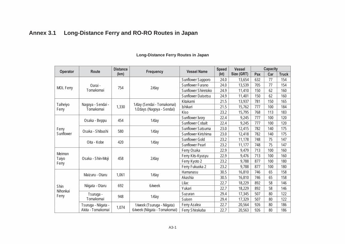
A3-1
Annex 3.1 Long-Distance Ferry and RO-RO Routes in Japan
Long-Distance Ferry Routes in Japan
Operator Route Distance(km) Frequency Vessel Name Speed
(kt) Vessel
Size (GRT) Capacity
Pax Car Truck
MOL Ferry Oarai - Tomakomai 754 2/day
Sunflower Sapporo 24.0 13,654 632 77 154 Sunflower Furano 24.0 13,539 705 77 154 Sunflower Shiretoko 24.9 11,410 150 62 160 Sunflower Daisetsu 24.9 11,401 150 62 160
TaiheiyoFerry
Nagoya - Sendai - Tomakomai 1,330 1/day (Sendai - Tomakomai)
1/2days (Nagoya - Sendai)
Kitakami 21.5 13,937 781 150 165 Ishikari 21.5 15,762 777 100 184 Kiso 23.2 15,795 768 113 183
Ferry Sunflower
Osaka - Beppu 454 1/day Sunflower Ivory 22.4 9,245 777 100 120 Sunflower Cobalt 22.4 9,245 777 100 120
Osaka - Shibushi 580 1/day Sunflower Satsuma 23.0 12,415 782 140 175 Sunflower Kirishima 23.0 12,418 782 140 175
Oita - Kobe 420 1/day Sunflower Gold 23.2 11,178 748 75 147 Sunflower Pearl 23.2 11,177 748 75 147
MeimonTaiyoFerry
Osaka - Shin-Moji 458 2/day
Ferry Osaka 22.9 9,479 713 100 160 Ferry Kits-Kyusyu 22.9 9,476 713 100 160 Ferry Kyoto 2 23.2 9,788 877 100 180 Ferry Fukuoka 2 23.2 9,788 877 100 180
ShinNihonkaiFerry
Maizuru - Otaru 1,061 1/day Hamanasu 30.5 16,810 746 65 158 Akashia 30.5 16,810 746 65 158
Niigata - Otaru 692 6/week Lilac 22.7 18,229 892 58 146Yukari 22.7 18,229 892 58 146
Tsuruga - Tomakomai 948 1/day Suzuran 29.4 17,345 507 80 122
Suisen 29.4 17,329 507 80 122 Tsuruga - Niigata - Akita - Tomakomai 1,074 1/week (Tsuruga - Niigata)
6/week (Niigata - Tomakomai) Ferry Azalea 22.7 20,564 926 80 186 Ferry Shirakaba 22.7 20,563 926 80 186

A3-2
Operator Route Distance(km) Frequency Vessel Name Speed
(kt) Vessel
Size (GRT) Capacity
Pax Car Truck
Hankyu Ferry
Shin-Moji - Izumiotsu 458 1/day Yamato 23.5 13,353 667 138 229
Tsukushi 23.5 13,353 667 138 229
Shin-Moji - Kobe 454 1/day Ferry Settsu 23.0 15,188 810 77 219 Ferry Suou 23.0 15,188 810 77 219
Ocean TokyuFerry
Kita-Kyushu - Tokushima -
Tokyo1,163 1/day
Ocean East 21.5 11,523 401 75 128 Ocean West 21.5 11,522 401 75 128 Ocean South 21.5 11,114 148 71 130 Ocean North 21.5 11,114 148 71 130
Miyazaki Car Ferry Miyazaki - Osaka 504 1/day Miyazaki Express 25.0 11,931 690 85 185
Osaka Express 25.0 11,933 690 85 185
Source: Japan Federation of Coastal Shipping Associations and Japan Long Course Ferry Service Association

A3-3
RO-RO and RO-RO Container Routes in Japan
Operator Route Distance
(km) Frequency Vessel Name Vessel Type
Speed
(kt)
Vessel
Size (GRT)
Capacity
Container Chassis Car
Kinkai Yusen
Logistics
Tsuruga - Tomakomai 948 1/day
Hokuto RO-RO 23.3 8,608 120
Tokachi RO-RO 23.2 9,858 128 103
Tsuruga RO-RO 23.3 8,608 120
Hitachinaka - Tomakomai 754 6/week Marimo RO-RO 21.7 8,348 128 152
Mashu RO-RO 21.7 8,349 - 128 152
Kawasaki
Kinkai Kisen
Hitachinaka - Tomakomai 754 6/week Yuuo-Maru RO-RO 20.7 9,348 105 61
Hokkaido-Maru RO-RO 20.0 12,526 160 46
Hitachi - Kushiro 791 1/day Hokuren-Maru RO-RO 23.5 13,950 130 64
Hokuren-Maru 2 RO-RO 23.5 13,950 130 64
Kita-Kyushu - Hitachinaka 1,213 2/week Yuuo-Maru RO-RO 20.7 9,348 105 61
Shin-Hokuo-Maru RO-RO 20.5 5,901 80
Hososhima - Aburatsu - Tokyo 1,012 2/week Nanno-Maru RO-RO 20.5 9,832 126 103
Nippon
Shipping
Tokyo - Tomakomai - Kushiro 1,239 4/2weeks
Himawari 1 RO-RO Container 23.0 7,323 200
(12ft)50
Himawari 2 RO-RO Container 23.0 7,323 200
(12ft)50
Himawari 3 RO-RO Container 21.5 7,754 300
(12ft)20
Tokyo - Uno/Iwakuni - Hakata 1,215 3/week Himawari 5 RO-RO 23.0 10,470 160 251
Himawari 6 RO-RO 23.0 10,471 160 251
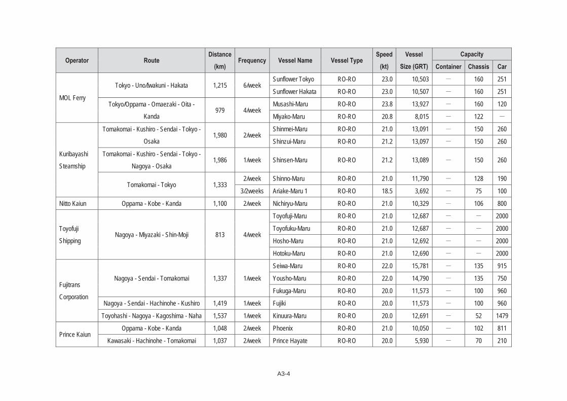
A3-4
Operator Route Distance
(km) Frequency Vessel Name Vessel Type
Speed
(kt)
Vessel
Size (GRT)
Capacity
Container Chassis Car
MOL Ferry
Tokyo - Uno/Iwakuni - Hakata 1,215 6/week Sunflower Tokyo RO-RO 23.0 10,503 160 251
Sunflower Hakata RO-RO 23.0 10,507 160 251
Tokyo/Oppama - Omaezaki - Oita -
Kanda979 4/week
Musashi-Maru RO-RO 23.8 13,927 160 120
Miyako-Maru RO-RO 20.8 8,015 122
Kuribayashi
Steamship
Tomakomai - Kushiro - Sendai - Tokyo -
Osaka1,980 2/week
Shinmei-Maru RO-RO 21.0 13,091 150 260
Shinzui-Maru RO-RO 21.2 13,097 150 260
Tomakomai - Kushiro - Sendai - Tokyo -
Nagoya - Osaka 1,986 1/week Shinsen-Maru RO-RO 21.2 13,089 150 260
Tomakomai - Tokyo 1,3332/week Shinno-Maru RO-RO 21.0 11,790 128 190
3/2weeks Ariake-Maru 1 RO-RO 18.5 3,692 75 100
Nitto Kaiun Oppama - Kobe - Kanda 1,100 2/week Nichiryu-Maru RO-RO 21.0 10,329 106 800
Toyofuji
Shipping Nagoya - Miyazaki - Shin-Moji 813 4/week
Toyofuji-Maru RO-RO 21.0 12,687 2000
Toyofuku-Maru RO-RO 21.0 12,687 2000
Hosho-Maru RO-RO 21.0 12,692 2000
Hotoku-Maru RO-RO 21.0 12,690 2000
Fujitrans
Corporation
Nagoya - Sendai - Tomakomai 1,337 1/week
Seiwa-Maru RO-RO 22.0 15,781 135 915
Yousho-Maru RO-RO 22.0 14,790 135 750
Fukuga-Maru RO-RO 20.0 11,573 100 960
Nagoya - Sendai - Hachinohe - Kushiro 1,419 1/week Fujiki RO-RO 20.0 11,573 100 960
Toyohashi - Nagoya - Kagoshima - Naha 1,537 1/week Kinuura-Maru RO-RO 20.0 12,691 52 1479
Prince Kaiun Oppama - Kobe - Kanda 1,048 2/week Phoenix RO-RO 21.0 10,050 102 811
Kawasaki - Hachinohe - Tomakomai 1,037 2/week Prince Hayate RO-RO 20.0 5,930 70 210
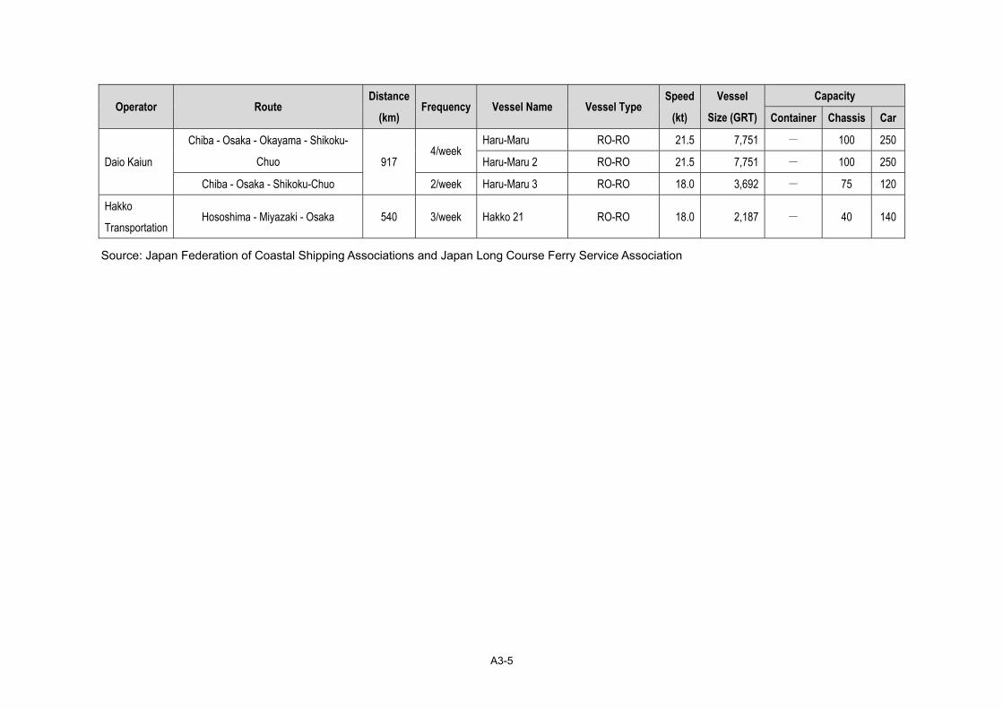
A3-5
Operator Route Distance
(km) Frequency Vessel Name Vessel Type
Speed
(kt)
Vessel
Size (GRT)
Capacity
Container Chassis Car
Daio Kaiun
Chiba - Osaka - Okayama - Shikoku-
Chuo 917 4/week
Haru-Maru RO-RO 21.5 7,751 - 100 250
Haru-Maru 2 RO-RO 21.5 7,751 - 100 250
Chiba - Osaka - Shikoku-Chuo 2/week Haru-Maru 3 RO-RO 18.0 3,692 - 75 120
Hakko
Transportation Hososhima - Miyazaki - Osaka 540 3/week Hakko 21 RO-RO 18.0 2,187 - 40 140
Source: Japan Federation of Coastal Shipping Associations and Japan Long Course Ferry Service Association

A3-7
Annex 3.2 Marine Accidents in the Philippines
Department of Transportation and Communications PUNONGHIMPILAN TANOD BAYBAYIN NG PILIPINAS
(HEADQUARTERS PHILIPPINE COAST GUARD) BOARD OF MARINE INQUIRY
139 25th Street, Port Area, 1018 Manila
MAJOR MARINE ACCIDENTS
VESSEL CASE NO. & NATURE
PLACE OF INCIDENT
DATE OF INCIDENT
BMI F&R (DATED)
CASUALTIES SURVIVOR BMI &SBMI FINDINGS
&RECOMMENDATION DATE
FORWARD TO LEGAL
DATE OF DECISION
STATUS ON APPEAL TO
DND/DOTC DATE FORWARD
DEAD MISSING
MV DONA PAZ Vs MT VECTOR BMI-653-87
(Collision)Tablas Strait
bet.Marinduqueand Mindoro
20 Dec. 1987
22 Mar 1988 1,827 13
Paz- - - 24 Vector - -2
26BMI found MT Vector
solely at fault 28 Mar 1988 29 Oct 1988
On appeal to SND
Dona Marilyn SBMI-08-88
(2CGD) (Sinking)
Vicinity bet. Tanguigui Island Manok-Manok
Island 24 Oct 1988
28 Mar 1989 77 2 300
SBMI 2CGD found that the sinking of the vessel
was due to force majeure 28 Aug 1989 20 July
1990 None
MV Cebu City Vs MV Kota Suria
BMI-819-94(Collision)
Lat. 14 degrees 24’-02” North Long
120 degrees 07’ 02 Dec 1994
05 Jan 1995 73 41 525 BMI found MV Kota Suria
solely at fault 05 Jan 1995 09 Jan 1995 On appeal to SND
MV Viva Antipolo VII
BMI-829-95(Burning/Sin
king)
Vicinity of Dalahican Fish Port, Lucena
16 May 1995
25 Aug 1995 62 10 142
Owner/Operator and Officers and Crew
Negligent 25 Nov 1995 21 Dec 1998 None
MV Kimelody Cristy
BMI-839-95(Burning)
5 Miles off Fortune Island
13 Dec 1995
15 May 1998 24 13 171
Owner/Operator and Officers and Crew
negligent 18 May 1998 05 Dec 2000
On appeal to DOTC
MV Princess of the Orient BMI_880-98
(Sinking)Vicinity of Fortune
Island 18 Sept
199827
Jan1999 70 80 355 The BMI found the officers negligent 27 Jan 1999 17 Feb
1999
On appeal to DOTC on 11 Feb
2000

A3-8
ML Gretchen I SBMI-01-96(Grounding)
CGD WV Cadiz City 18 Feb 1996
29 Nov 1996
51 0 145Owner/Operator officer
and crew negligent 13 Jan 1997 17 Jul 1997 None
FB Toroshita SBMI-01-91
(Sinking)CGD NCR-CL
Simirara Island, Antique
28 Mar 1991
15 Apr 1991 5 18 15 Owner/Operator and
Patron negligent 18 Apr 1991 No decision None
MV Emerald I SBMI-002-91(sinking) CGD
ST Matuco Point 17 Jul 1991 11 Dec 1991
3 2 81Officers and Crew found
negligent 26 Dec 1991 21 Feb 1992 None
FB King Roger SBMI-110-97(Capsizing)
CGD NCR-CL Manila Bay, South
Harbor, Manila 15 Aug 1997
14 Oct 1997 0 7 41 Owner/Operator and
Patron negligent 14 Oct 1997 23 Oct 1997 None
MV Kalibo Star SBMI-03-97
(Sinking)2CGD CGD
CV
Vicinity of Tincasan pt.bet.
Maripipi and Biliran Island
15 Aug 1997
08 Oct 1997 12 18 107
Negligence and imprudence of Shipowner and negligence of officers 09 Dec 1997 06 Nov
1998 None
ML Annahada SBMI-001-00
(Sinking)CGD SM-Z
Vicinity 1.2 NM off Jolo Pier, Jolo
Sulu 12 Apr 2000
17 Jul 2000 124 14 138
Owner/Operator and Patron negligent 07 Sept 2000 No decision None
MV Asia South Korea
SBMI-04-99 (Sinking)
CGD NCR-CL Coast of Bantayan
way23 Dec 1999
15Aug2000 58 0 699
Negligence of Captain and navigating officer None
Resolutionby DOTC
Investigation Panel
None
MV ACXLILAC Vs Barge
CARGOLIFT-III
SBMI-111-2000
(Collision)CGD NCR-CL
Lat. 14 degrees 26.7 min. North
Long 12.0” degrees 41.7 Min
NE
02 Sept 2000
09 Mar 2001
04 2
Navigating officer and Master negligent 04 Apr 2001 None
MV Maria Carmela SBMI-01-02 (Burning)
Vicinity of Pagbilao, Quezon
11 Apr 2002
02 May& 03 June2002
39 6Crews
95 (injured-hospital)176 (not
injured , no record)
371person
SBMI found Owner officer and crew negligent
Forwarded to SOTC
10 May 2002 None None
M/B NILODE-A SBMI-04-02(Sinking)
Vicinity of Bgy. Antipolo, Naval 11 May
200212 June
200219 0 79 Operator and Patron
found negligent 09 Sept 2002 None None

A3-9
M/V Super Ferry 12 Vs M/V San
NicholasSBMI-01-03 (Collision)
Vicinity of 1NM Limbones Island 25 May
200306 June
2003 43 21 182
Master of M/V Superferry 12 be strongly
reprimanded w/Stern Warning
Master & Chief Mate of M/V San Nicholas
revocation of there Major Patron License, Filing
appropriate criminal & civil charge.
Forwarded to Sec. DOTC
06 June 2003 None None
M/V Super Ferry 14
SBMI-001-04 Fire on Board
/Burning
Off El Fraile at Lat. 14 deg. 19 mins N,
Long. 120 deg. 37.4 mins E.
270030HFeb 04
16 Apr 04 & 27 Sep 04
94 24 781 Fire or Explosion is undetermined and
explosion due to explosive
Forwarded to Sec. DOTC 29 Sep 04
Forresolution ,
DOTC
M/V Doña Ramona SBMI-SWM-001-05 Fire on Board
Vic. Of Kulaybato Wharf located on Brgy Kulaybato, Lamitan, Basilan
280700HAugust2005
31January
20061 died 0 29 injured
Explosion on board caused by an improvised explosive device. Board
strictly direct the ARMM to adopt the ISPS Code.
Forwarded to Sec. DOTC
on March 22, 2006
M/T Solar-I SBMI-936-06 Sinking
Vicinity of Guimaras Island
on11 August
200614
September 2006
0 2 16
Board finds several factors as follows: Loss of
reserved buoyancy, loss of residual stability and Master’s incompetence.
Forwarded to Sec. DOTC
on September 26, 2006
M/V CATALYN-D SBMI-STL-001-2007Burning/Sinking
Vicinity of Calintugan,
Calavite point 10 June
2007 5 12 282survivor On going hearing
M/V Blue WaterPrincess SBMI-03-007
Vicinity of Bondoc Point San
Francisco, Quezon 12 July 2007 11 0 126 On going hearing
M/V Princess of the Stars
BMI-941-08 Capzising
Vicinity off Sibuyan Island
21 June 2008
*SOURCE: BOARD OF MARINE INQUIRY (BMI) FILES
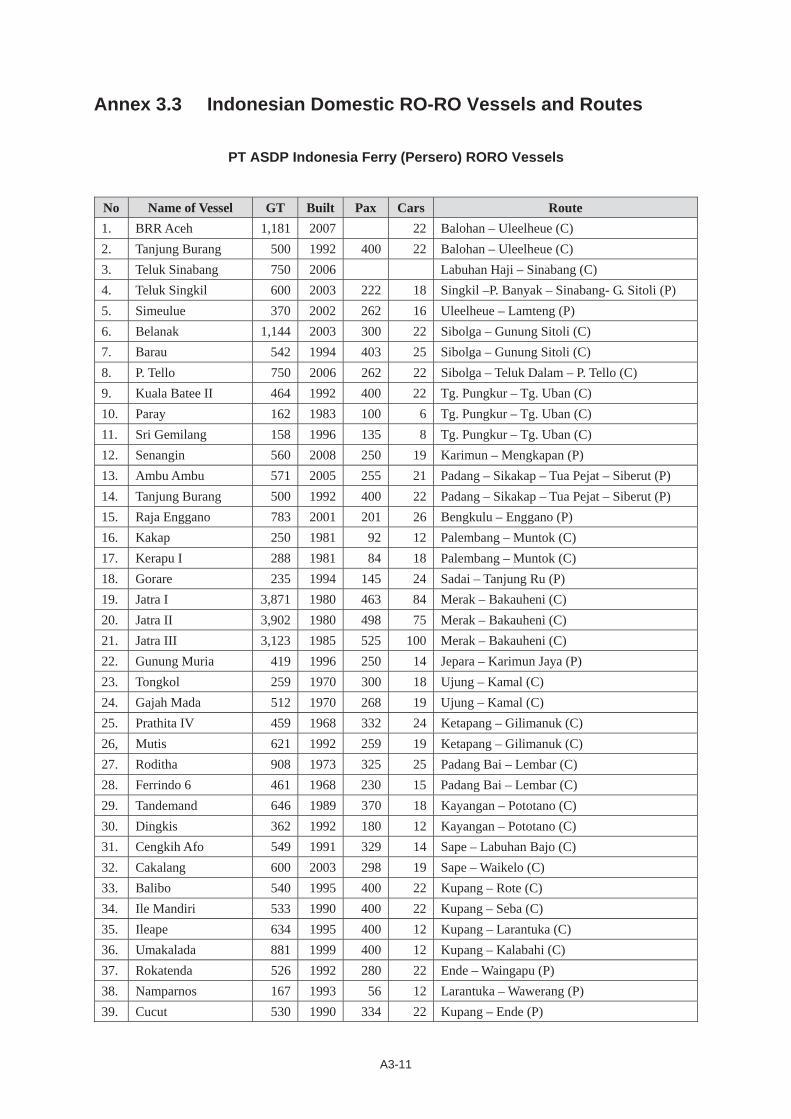
A3-11
Annex 3.3 Indonesian Domestic RO-RO Vessels and Routes
PT ASDP Indonesia Ferry (Persero) RORO Vessels
No Name of Vessel GT Built Pax Cars Route 1. BRR Aceh 1,181 2007 22 Balohan – Uleelheue (C) 2. Tanjung Burang 500 1992 400 22 Balohan – Uleelheue (C) 3. Teluk Sinabang 750 2006 Labuhan Haji – Sinabang (C) 4. Teluk Singkil 600 2003 222 18 Singkil –P. Banyak – Sinabang- G. Sitoli (P) 5. Simeulue 370 2002 262 16 Uleelheue – Lamteng (P) 6. Belanak 1,144 2003 300 22 Sibolga – Gunung Sitoli (C) 7. Barau 542 1994 403 25 Sibolga – Gunung Sitoli (C) 8. P. Tello 750 2006 262 22 Sibolga – Teluk Dalam – P. Tello (C) 9. Kuala Batee II 464 1992 400 22 Tg. Pungkur – Tg. Uban (C) 10. Paray 162 1983 100 6 Tg. Pungkur – Tg. Uban (C) 11. Sri Gemilang 158 1996 135 8 Tg. Pungkur – Tg. Uban (C) 12. Senangin 560 2008 250 19 Karimun – Mengkapan (P) 13. Ambu Ambu 571 2005 255 21 Padang – Sikakap – Tua Pejat – Siberut (P) 14. Tanjung Burang 500 1992 400 22 Padang – Sikakap – Tua Pejat – Siberut (P) 15. Raja Enggano 783 2001 201 26 Bengkulu – Enggano (P) 16. Kakap 250 1981 92 12 Palembang – Muntok (C) 17. Kerapu I 288 1981 84 18 Palembang – Muntok (C) 18. Gorare 235 1994 145 24 Sadai – Tanjung Ru (P) 19. Jatra I 3,871 1980 463 84 Merak – Bakauheni (C) 20. Jatra II 3,902 1980 498 75 Merak – Bakauheni (C) 21. Jatra III 3,123 1985 525 100 Merak – Bakauheni (C) 22. Gunung Muria 419 1996 250 14 Jepara – Karimun Jaya (P) 23. Tongkol 259 1970 300 18 Ujung – Kamal (C) 24. Gajah Mada 512 1970 268 19 Ujung – Kamal (C) 25. Prathita IV 459 1968 332 24 Ketapang – Gilimanuk (C) 26, Mutis 621 1992 259 19 Ketapang – Gilimanuk (C) 27. Roditha 908 1973 325 25 Padang Bai – Lembar (C) 28. Ferrindo 6 461 1968 230 15 Padang Bai – Lembar (C) 29. Tandemand 646 1989 370 18 Kayangan – Pototano (C) 30. Dingkis 362 1992 180 12 Kayangan – Pototano (C) 31. Cengkih Afo 549 1991 329 14 Sape – Labuhan Bajo (C) 32. Cakalang 600 2003 298 19 Sape – Waikelo (C) 33. Balibo 540 1995 400 22 Kupang – Rote (C) 34. Ile Mandiri 533 1990 400 22 Kupang – Seba (C) 35. Ileape 634 1995 400 12 Kupang – Larantuka (C) 36. Umakalada 881 1999 400 12 Kupang – Kalabahi (C) 37. Rokatenda 526 1992 280 22 Ende – Waingapu (P) 38. Namparnos 167 1993 56 12 Larantuka – Wawerang (P) 39. Cucut 530 1990 334 22 Kupang – Ende (P)
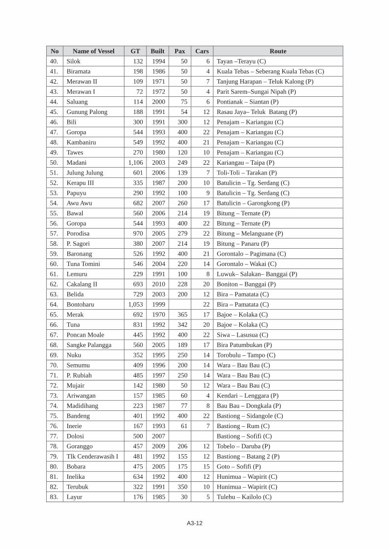
A3-12
No Name of Vessel GT Built Pax Cars Route 40. Silok 132 1994 50 6 Tayan –Terayu (C) 41. Biramata 198 1986 50 4 Kuala Tebas – Seberang Kuala Tebas (C) 42. Merawan II 109 1971 50 7 Tanjung Harapan – Teluk Kalong (P) 43. Merawan I 72 1972 50 4 Parit Sarem–Sungai Nipah (P) 44. Saluang 114 2000 75 6 Pontianak – Siantan (P) 45. Gunung Palong 188 1991 54 12 Rasau Jaya– Teluk Batang (P) 46. Bili 300 1991 300 12 Penajam – Kariangau (C) 47. Goropa 544 1993 400 22 Penajam – Kariangau (C) 48. Kambaniru 549 1992 400 21 Penajam – Kariangau (C) 49. Tawes 270 1980 120 10 Penajam – Kariangau (C) 50. Madani 1,106 2003 249 22 Kariangau – Taipa (P) 51. Julung Julung 601 2006 139 7 Toli-Toli – Tarakan (P) 52. Kerapu III 335 1987 200 10 Batulicin – Tg. Serdang (C) 53. Papuyu 290 1992 100 9 Batulicin – Tg. Serdang (C) 54. Awu Awu 682 2007 260 17 Batulicin – Garongkong (P) 55. Bawal 560 2006 214 19 Bitung – Ternate (P) 56. Goropa 544 1993 400 22 Bitung – Ternate (P) 57. Porodisa 970 2005 279 22 Bitung – Melanguane (P) 58. P. Sagori 380 2007 214 19 Bitung – Panaru (P) 59. Baronang 526 1992 400 21 Gorontalo – Pagimana (C) 60. Tuna Tomini 546 2004 220 14 Gorontalo – Wakai (C) 61. Lemuru 229 1991 100 8 Luwuk– Salakan– Banggai (P) 62. Cakalang II 693 2010 228 20 Boniton – Banggai (P) 63. Belida 729 2003 200 12 Bira – Pamatata (C) 64. Bontoharu 1,053 1999 22 Bira – Pamatata (C) 65. Merak 692 1970 365 17 Bajoe – Kolaka (C) 66. Tuna 831 1992 342 20 Bajoe – Kolaka (C) 67. Poncan Moale 445 1992 400 22 Siwa – Lasusua (C) 68. Sangke Palangga 560 2005 189 17 Bira Patumbukan (P) 69. Nuku 352 1995 250 14 Torobulu – Tampo (C) 70. Semumu 409 1996 200 14 Wara – Bau Bau (C) 71. P. Rubiah 485 1997 250 14 Wara – Bau Bau (C) 72. Mujair 142 1980 50 12 Wara – Bau Bau (C) 73. Ariwangan 157 1985 60 4 Kendari – Lenggara (P) 74. Madidihang 223 1987 77 8 Bau Bau – Dongkala (P) 75. Bandeng 401 1992 400 22 Bastiong – Sidangole (C) 76. Inerie 167 1993 61 7 Bastiong – Rum (C) 77. Dolosi 500 2007 Bastiong – Sofifi (C) 78. Goranggo 457 2009 206 12 Tobelo – Daruba (P) 79. Tlk Cenderawasih I 481 1992 155 12 Bastiong – Batang 2 (P) 80. Bobara 475 2005 175 15 Goto – Sofifi (P) 81. Inelika 634 1992 400 12 Hunimua – Wapirit (C) 82. Terubuk 322 1991 350 10 Hunimua – Wapirit (C) 83. Layur 176 1985 30 5 Tulehu – Kailolo (C)
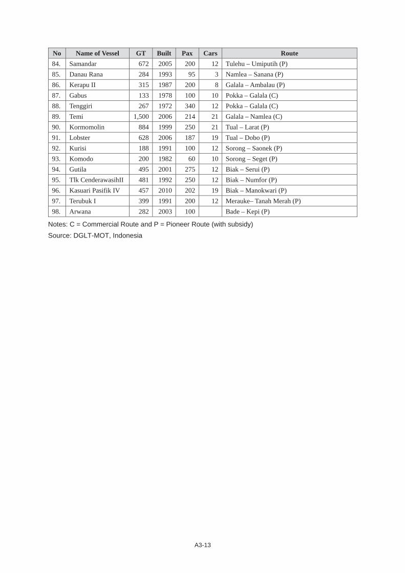
A3-13
No Name of Vessel GT Built Pax Cars Route 84. Samandar 672 2005 200 12 Tulehu – Umiputih (P) 85. Danau Rana 284 1993 95 3 Namlea – Sanana (P) 86. Kerapu II 315 1987 200 8 Galala – Ambalau (P) 87. Gabus 133 1978 100 10 Pokka – Galala (C) 88. Tenggiri 267 1972 340 12 Pokka – Galala (C) 89. Temi 1,500 2006 214 21 Galala – Namlea (C) 90. Kormomolin 884 1999 250 21 Tual – Larat (P) 91. Lobster 628 2006 187 19 Tual – Dobo (P) 92. Kurisi 188 1991 100 12 Sorong – Saonek (P) 93. Komodo 200 1982 60 10 Sorong – Seget (P) 94. Gutila 495 2001 275 12 Biak – Serui (P) 95. Tlk CenderawasihII 481 1992 250 12 Biak – Numfor (P) 96. Kasuari Pasifik IV 457 2010 202 19 Biak – Manokwari (P) 97. Terubuk I 399 1991 200 12 Merauke– Tanah Merah (P) 98. Arwana 282 2003 100 Bade – Kepi (P)
Notes: C = Commercial Route and P = Pioneer Route (with subsidy) Source: DGLT-MOT, Indonesia

A3-14
Private Shipping Companies RORO/Ferry Vessels (Under DGLT Authority)
No Shipping Company Vessel's Name GT Built Pax Car Route 1 PT Pewete Aeng Mas 402 1987 297 31 Air Putih - Sei Seleri (C) Banyu Mas 552 1985 216 53 Air Putih - Sei Seleri (C) 2 PT Dharma Lautan
Utama
Dharma Ferry 342 1980 500 45 Palembang - Muntok (C)
Mustika Kencana 4183 1992 586 60 Merak - Bakaheuni (C)
Joko Tole 192 1976 256 15 Ujung - Kamal (C) Pottre Koneng 797 1988 700 50 Ujung - Kamal (C) Wicitra Dharma 589 1986 500 65 Ujung - Kamal (C) Dharma Kartika 259 1987 250 4 Jangkar - Kalianget (P) Dharma Badra 193 1984 150 30 Ketapang - Gilimanuk (C) Dharma Ferry I 421 1986 400 50 Ketapang - Gilimanuk (C) Dharma Rucitra 468 1964 320 24 Ketapang - Gilimanuk (C) Dharma Ferry IX 2916 1989 Padang Bai - Lembar (C) Dharma Kosala 625 1979 450 35 Padang Bai - Lembar (C) Dharma Sentosa 536 1984 300 25 Padang Bai - Lembar (C) Dharma Sentosa 536 1984 300 25 Nusa Penida - Padang Bai (C) Satya Dharma 481 1969 172 18 Nusa Penida - Padang Bai (C) Dewana Dharma 560 1989 320 18 Sape - Labuhan Bajo (C) Dharma Badra 193 1984 150 30 Sape - Labuhan Bajo (C) Truno Joyo 178 1976 150 15 Sape - Labuhan Bajo (C) Ulin Ferry 244 1991 240 26 Sape - Labuhan Bajo (C)
3 PT Jembatan Madura Jembatan Musi I 406 1972 145 24 Palembang - Muntok (C)
Jembatan Musi II 148 1967 60 12 Palembang - Muntok (C) Mulia Nusantara 425 1971 188 26 Palembang - Muntok (C) Mitra Nusantara 5813 1994 800 150 Merak - Bakaheuni (C) Panorama Nusantara 8915 1995 1200 150 Merak - Bakaheuni (C) Prima Nusantara 2773 1990 976 110 Merak - Bakaheuni (C) Royal Nusantara 6034 1992 1005 100 Merak - Bakaheuni (C) Titian Murni 3614 1982 840 45 Merak - Bakaheuni (C) Titian Nusantara 5532 1992 1200 150 Merak - Bakaheuni (C) Bahari Nusantara 846 1969 330 42 Ujung - Kamal (C) Selat Madura I 209 1980 367 15 Ujung - Kamal (C) Selat Madura II 209 1980 223 15 Ujung - Kamal (C) Marina Pratama 688 1993 280 40 Ketapang - Gilimanuk (C) Pertiwi Nusantara 605 1985 500 25 Ketapang - Gilimanuk (C) RaJavali Nusantara 585 1989 360 12 Ketapang - Gilimanuk (C) Reny II 456 1968 500 30 Ketapang - Gilimanuk (C) Satria Nusantara 656 1984 450 75 Ketapang - Gilimanuk (C) Adhi Swadharma III 511 1984 500 25 Padang Bai - Lembar (C) Citra Nusantara 1007 1992 333 25 Padang Bai - Lembar (C) Gading Nusantara 1325 1992 250 22 Padang Bai - Lembar (C) Marina Primera 824 1990 290 22 Padang Bai - Lembar (C)
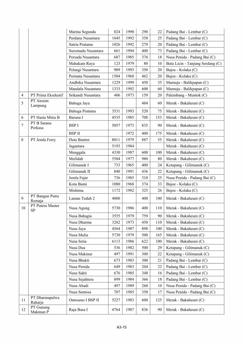
A3-15
Marina Segunda 824 1990 290 22 Padang Bai - Lembar (C) Perdana Nusantara 1645 1992 358 25 Padang Bai - Lembar (C) Satria Pratama 1026 1992 279 20 Padang Bai - Lembar (C) Suromadu Nusantara 661 1994 400 73 Padang Bai - Lembar (C) Persada Nusantara 687 1985 376 18 Nusa Penida - Padang Bai (C) Mahakam Raya 123 1979 80 10 Batu Licin - Tanjung Serdang (C) Pelangi Nusantara 909 1993 350 20 Bajoe - Kolaka (C) Permata Nusantara 1504 1968 462 20 Bajoe - Kolaka (C) Andhika Nusantara 1229 1999 450 35 Mamuju - Balikpapan (C) Mandala Nusantara 1333 1992 600 60 Mamuju - Balikpapan (C) 4 PT Prima Eksekutif Srikandi Nusantara 406 1973 159 20 Palembang - Muntok (C)
5 PT Atosim Lampung Bahuga Jaya 484 60 Merak - Bakaheuni (C)
Bahuga Pratama 3531 1993 520 75 Merak - Bakaheuni (C) 6 PT Hasta Mitra B Baruna I 4535 1985 708 153 Merak - Bakaheuni (C)
7 PT B Sarana Perkasa BSP I 5057 1973 835 90 Merak - Bakaheuni (C)
BSP II 1972 400 175 Merak - Bakaheuni (C) 8 PT Jemla Ferry Duta Banten 8011 1979 887 55 Merak - Bakaheuni (C) Jagantara 5193 1984 Merak - Bakaheuni (C) Menggala 4330 1987 600 100 Merak - Bakaheuni (C) Mufidah 5584 1977 980 80 Merak - Bakaheuni (C) Gilimanuk I 733 1965 400 24 Ketapang - Gilimanuk (C) Gilimanuk II 840 1991 436 22 Ketapang - Gilimanuk (C) Jemla Fajar 736 1985 310 25 Nusa Penida - Padang Bai (C) Kota Bumi 1080 1968 374 33 Bajoe - Kolaka (C) Mishima 1172 1982 325 26 Bajoe - Kolaka (C)
9 PT Bangun Putra Remaja Lautan Teduh 2 4000 400 100 Merak - Bakaheuni (C)
10 PT Putera Master SP Nusa Agung 5730 1986 400 110 Merak - Bakaheuni (C)
Nusa Bahagia 3555 1979 759 90 Merak - Bakaheuni (C) Nusa Dharma 3282 1973 450 110 Merak - Bakaheuni (C) Nusa Jaya 4564 1987 898 100 Merak - Bakaheuni (C) Nusa Mulia 5730 1979 500 165 Merak - Bakaheuni (C) Nusa Setia 6113 1986 622 100 Merak - Bakaheuni (C) Nusa Dua 536 1982 500 29 Ketapang - Gilimanuk (C) Nusa Makmur 497 1991 300 22 Ketapang - Gilimanuk (C) Nusa Bhakti 673 1983 300 21 Padang Bai - Lembar (C) Nusa Penida 649 1983 204 22 Padang Bai - Lembar (C) Nusa Sakti 676 1985 348 16 Padang Bai - Lembar (C) Nusa Sejahtera 899 1984 366 18 Padang Bai - Lembar (C) Nusa Abadi 497 1989 260 10 Nusa Penida - Padang Bai (C) Nusa Sentosa 707 1985 350 17 Nusa Penida - Padang Bai (C)
11 PT Dharmapalwa Raharja Ontoseno I BSP II 5227 1983 600 125 Merak - Bakaheuni (C)
12 PT Gunung Makmun P Raja Basa I 4764 1987 836 90 Merak - Bakaheuni (C)
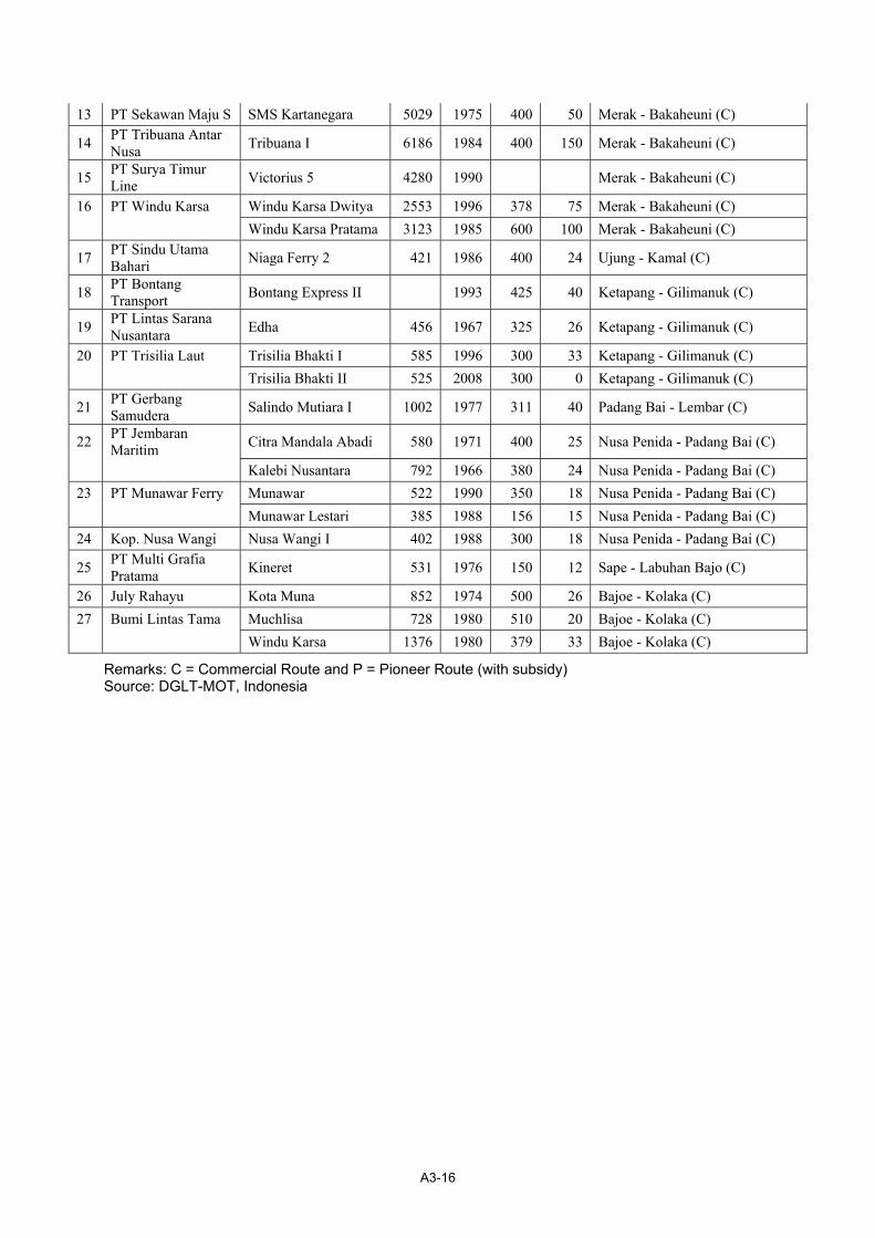
A3-16
13 PT Sekawan Maju S SMS Kartanegara 5029 1975 400 50 Merak - Bakaheuni (C)
14 PT Tribuana Antar Nusa Tribuana I 6186 1984 400 150 Merak - Bakaheuni (C)
15 PT Surya Timur Line Victorius 5 4280 1990 Merak - Bakaheuni (C)
16 PT Windu Karsa Windu Karsa Dwitya 2553 1996 378 75 Merak - Bakaheuni (C) Windu Karsa Pratama 3123 1985 600 100 Merak - Bakaheuni (C)
17 PT Sindu Utama Bahari Niaga Ferry 2 421 1986 400 24 Ujung - Kamal (C)
18 PT Bontang Transport Bontang Express II 1993 425 40 Ketapang - Gilimanuk (C)
19 PT Lintas Sarana Nusantara Edha 456 1967 325 26 Ketapang - Gilimanuk (C)
20 PT Trisilia Laut Trisilia Bhakti I 585 1996 300 33 Ketapang - Gilimanuk (C) Trisilia Bhakti II 525 2008 300 0 Ketapang - Gilimanuk (C)
21 PT Gerbang Samudera Salindo Mutiara I 1002 1977 311 40 Padang Bai - Lembar (C)
22 PT Jembaran Maritim Citra Mandala Abadi 580 1971 400 25 Nusa Penida - Padang Bai (C)
Kalebi Nusantara 792 1966 380 24 Nusa Penida - Padang Bai (C) 23 PT Munawar Ferry Munawar 522 1990 350 18 Nusa Penida - Padang Bai (C) Munawar Lestari 385 1988 156 15 Nusa Penida - Padang Bai (C) 24 Kop. Nusa Wangi Nusa Wangi I 402 1988 300 18 Nusa Penida - Padang Bai (C)
25 PT Multi Grafia Pratama Kineret 531 1976 150 12 Sape - Labuhan Bajo (C)
26 July Rahayu Kota Muna 852 1974 500 26 Bajoe - Kolaka (C) 27 Bumi Lintas Tama Muchlisa 728 1980 510 20 Bajoe - Kolaka (C) Windu Karsa 1376 1980 379 33 Bajoe - Kolaka (C)
Remarks: C = Commercial Route and P = Pioneer Route (with subsidy) Source: DGLT-MOT, Indonesia
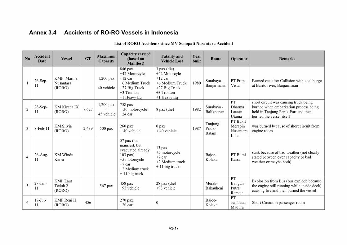
A3-17
Annex 3.4 Accidents of RO-RO Vessels in Indonesia
List of RORO Accidents since MV Senopati Nusantara Accident
No Accident Date Vessel GT Maximum
Capacity
Capacity carried (based on Manifest)
Fatality and Vehicle Lost
Year built Route Operator Remarks
1 26-Sep-11
KMP Marina Nusantara (RORO)
1,200 pax +
40 vehicle
846 pax +42 Motorcyle +12 car +6 Medium Truck +27 Big Truck +3 Tronton +1 Heavy Eq
3 pax (die) +42 Motorcyle +12 car +6 Medium Truck +27 Big Truck +3 Tronton +1 Heavy Eq
1980 Surabaya-Banjarmasin
PT Prima Vista
Burned out after Collision with coal barge at Barito river, Banjarmasin
2 28-Sep-11
KM Kirana IX (RORO) 8,627
1,200 pax +
45 vehicle
758 pax + 36 motorcycle +24 car
8 pax (die) 1982 Surabaya - Balikpapan
PT Dharma Lautan Utama
short circuit was causing truck being burned when embarkation process being held in Tanjung Perak Port and then burned the vessel itself
3 8-Feb-11 KM Silvia (RORO) 2,439 500 pax 260 pax
+ 40 vehicle 0 pax + 40 vehicle 1987
Tanjung Priok-Batam
PT Bukit Merapin Nusantara Line
was burned because of short circuit from engine room
4 26-Aug-11
KM Windu Karsa
57 pax ( in manifest, but evacuated already 103 pax) +5 motorcycle +7 car +2 Medium truck + 11 big truck
13 pax +5 motorcycle +7 car +2 Medium truck + 11 big truck
Bajoe- Kolaka
PT Bumi Karsa
sunk because of bad weather (not clearly stated between over capacity or bad weather or maybe both)
5 28-Jan-11
KMP Laut Teduh 2 (RORO) 567 pax 458 pax
+93 vehicle 28 pax (die) +93 vehicle
Merak-Bakauheni
PT Bangun Putra Remaja
Explosion from Bus (bus explode because the engine still running while inside deck) causing fire and then burned the vessel
6 17-Jul-11
KMP Reni II (RORO) 456
270 pax +20 car 0
Bajoe- Kolaka
PT Jembatan Madura
Short Circuit in passenger room
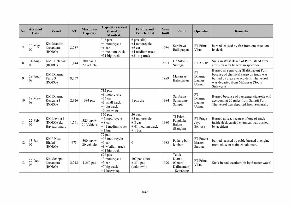
A3-18
No Accident Date Vessel GT Maximum
Capacity
Capacity carried (based on Manifest)
Fatality and Vehicle Lost
Year built Route Operator Remarks
7 30-May-09
KM Mandiri Nusantara (RORO)
8,257
302 pax +4 motorcycle +6 car +4 medium truck +31 big truck
6 pax (die) +4 motorcycle +6 car +4 medium truck +31 big truck
1989 Surabaya-Balikpapan
PT Prima Vista
burned, caused by fire from one truck on its deck
8 31-Aug-08
KMP Belanak (RORO) 1,144 300 pax +
22 vehicle 2003 Gn Sitoli - Sibolga PT ASDP Sunk in West Beach of Putri Island after
collision with fisherman speedboat
9 28-Aug-08
KM Dharma Ferry 3 (RORO)
8,257 1989 Makassar-Balikpapan
PT Dharma Lautan Utama
Burned at Semayang (Balikpapan) Port because of chemical cargo on truck was burned by cigarette accident. The vessel was departed from Makassar (South Sulawesi)
10 18-May-08
KM Dharma Kencana I (RORO)
2,326 684 pax
712 pax +8 motorcycle +14 car +3 small truck +4 big truck +6 heavy eq
1 pax die 1984 Surabaya-Semarang-Sampit
PT Dharma Lautan Utama
Burned because of passenger cigarette end accident, at 20 miles from Sampit Port. The vessel was departed from Semarang
11 22-Feb-07
KM Levina I (RORO) eks Hayazurumaru
1,791 325 pax + 50 Vehicle
350 pax + 5 motorcycle + 8 car + 41 medium truck + 1 bus
50 pax +5 motorcycle + 8 car + 41 medium truck + 1 bus
1980
Tj Priok - Pangkalan Balam (Bangka) -
PT Praga Jaya Sentosa
Burned at sea, because of one of truck inside deck carried chemical was burned by accident
12 13-Jan-07
KMP Nusa Bhakti (RORO)
673 300 pax + 20 vehicle
72 pax +16 motorcycle +1 car +8 Medium truck +11 big truck
0 1983 Padang bai - lembar
PT Putera Master Sarana
burned, caused by cable burned at engine room close to main swicth board
13 29-Dec-06
KM Senopati Nusantara (RORO)
2,718 1,250 pax
628 pax +3 motorcycle +3 car +7 big truck + 1 heavy eq.
107 pax (die) + 314 pax (unknown)
1990
Teluk Kumai (Central Kalimantan) - Semarang
PT Prima Vista Sunk in bad weather (hit by 6 meter wave)

ANNEX TO CHAPTER 5
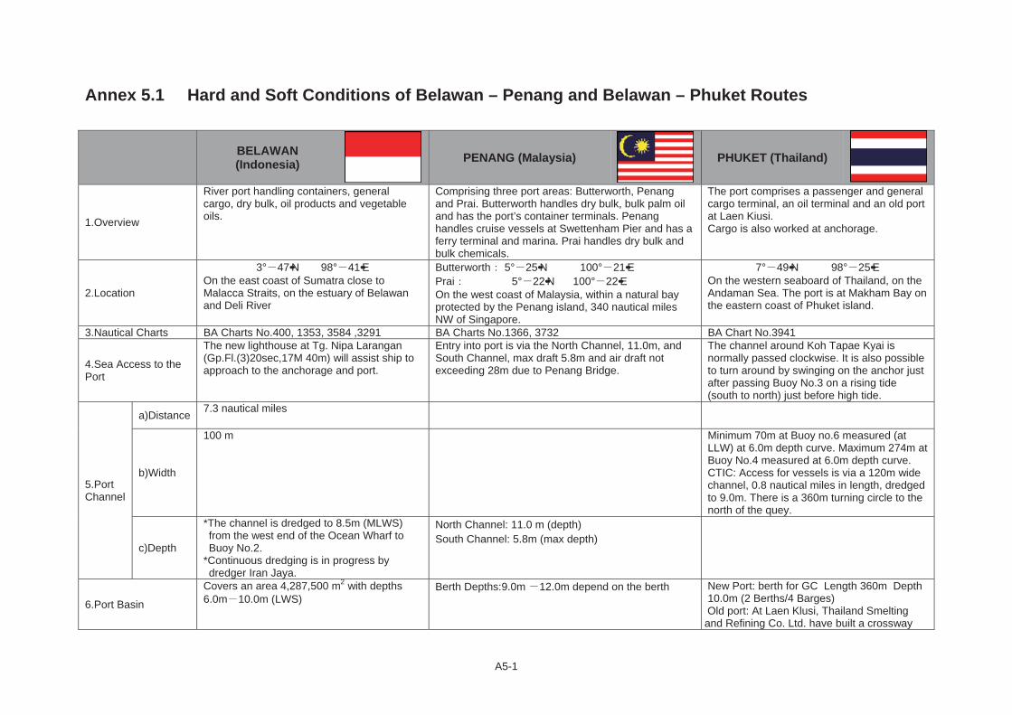
A5-1
Annex 5.1 Hard and Soft Conditions of Belawan – Penang and Belawan – Phuket Routes
BELAWAN (Indonesia) PENANG (Malaysia) PHUKET (Thailand)
1.Overview
River port handling containers, general cargo, dry bulk, oil products and vegetable oils.
Comprising three port areas: Butterworth, Penang and Prai. Butterworth handles dry bulk, bulk palm oil and has the port’s container terminals. Penang handles cruise vessels at Swettenham Pier and has a ferry terminal and marina. Prai handles dry bulk and bulk chemicals.
The port comprises a passenger and general cargo terminal, an oil terminal and an old port at Laen Kiusi. Cargo is also worked at anchorage.
2.Location
3° 47••N 98° 41••EOn the east coast of Sumatra close to Malacca Straits, on the estuary of Belawan and Deli River
Butterworth 5° 25••N 100° 21••EPrai 5° 22••N 100° 22••EOn the west coast of Malaysia, within a natural bay protected by the Penang island, 340 nautical miles NW of Singapore.
7° 49••N 98° 25••EOn the western seaboard of Thailand, on the Andaman Sea. The port is at Makham Bay on the eastern coast of Phuket island.
3.Nautical Charts BA Charts No.400, 1353, 3584 ,3291 BA Charts No.1366, 3732 BA Chart No.3941
4.Sea Access to the Port
The new lighthouse at Tg. Nipa Larangan (Gp.Fl.(3)20sec,17M 40m) will assist ship to approach to the anchorage and port.
Entry into port is via the North Channel, 11.0m, and South Channel, max draft 5.8m and air draft not exceeding 28m due to Penang Bridge.
The channel around Koh Tapae Kyai is normally passed clockwise. It is also possible to turn around by swinging on the anchor just after passing Buoy No.3 on a rising tide (south to north) just before high tide.
5.PortChannel
a)Distance 7.3 nautical miles
b)Width
100 m Minimum 70m at Buoy no.6 measured (at LLW) at 6.0m depth curve. Maximum 274m at Buoy No.4 measured at 6.0m depth curve. CTIC: Access for vessels is via a 120m wide channel, 0.8 nautical miles in length, dredged to 9.0m. There is a 360m turning circle to the north of the quey.
c)Depth
*The channel is dredged to 8.5m (MLWS) from the west end of the Ocean Wharf to Buoy No.2.
*Continuous dredging is in progress by dredger Iran Jaya.
North Channel: 11.0 m (depth) South Channel: 5.8m (max depth)
6.Port Basin
Covers an area 4,287,500 m2 with depths 6.0m 10.0m (LWS)
Berth Depths:9.0m 12.0m depend on the berth New Port: berth for GC Length 360m Depth 10.0m (2 Berths/4 Barges) Old port: At Laen Klusi, Thailand Smelting and Refining Co. Ltd. have built a crossway
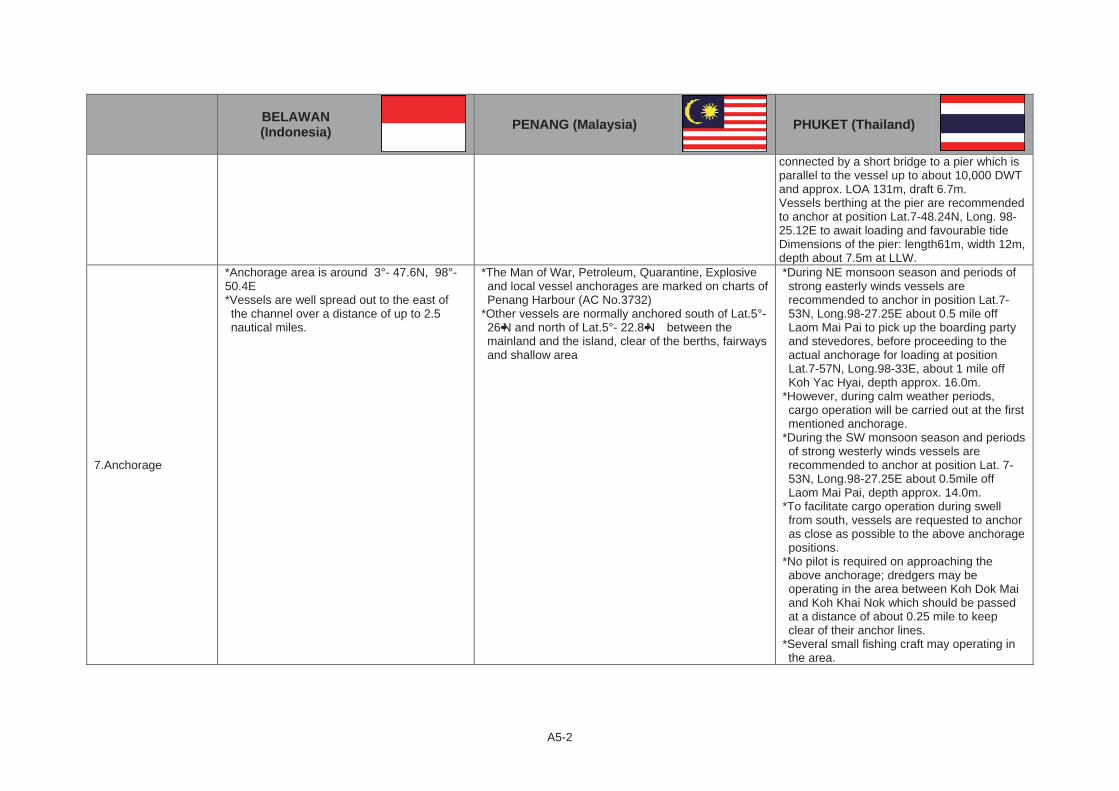
A5-2
BELAWAN (Indonesia) PENANG (Malaysia) PHUKET (Thailand)
connected by a short bridge to a pier which is parallel to the vessel up to about 10,000 DWT and approx. LOA 131m, draft 6.7m. Vessels berthing at the pier are recommended to anchor at position Lat.7-48.24N, Long. 98-25.12E to await loading and favourable tide Dimensions of the pier: length61m, width 12m, depth about 7.5m at LLW.
7.Anchorage
*Anchorage area is around 3°- 47.6N, 98°- 50.4E *Vessels are well spread out to the east of the channel over a distance of up to 2.5 nautical miles.
*The Man of War, Petroleum, Quarantine, Explosive and local vessel anchorages are marked on charts of Penang Harbour (AC No.3732)
*Other vessels are normally anchored south of Lat.5°- 26••N and north of Lat.5°- 22.8••N between the mainland and the island, clear of the berths, fairways and shallow area
*During NE monsoon season and periods of strong easterly winds vessels are recommended to anchor in position Lat.7-53N, Long.98-27.25E about 0.5 mile off Laom Mai Pai to pick up the boarding party and stevedores, before proceeding to the actual anchorage for loading at position Lat.7-57N, Long.98-33E, about 1 mile off Koh Yac Hyai, depth approx. 16.0m.
*However, during calm weather periods, cargo operation will be carried out at the first mentioned anchorage.
*During the SW monsoon season and periods of strong westerly winds vessels are recommended to anchor at position Lat. 7-53N, Long.98-27.25E about 0.5mile off Laom Mai Pai, depth approx. 14.0m.
*To facilitate cargo operation during swell from south, vessels are requested to anchor as close as possible to the above anchorage positions.
*No pilot is required on approaching the above anchorage; dredgers may be operating in the area between Koh Dok Mai and Koh Khai Nok which should be passed at a distance of about 0.25 mile to keep clear of their anchor lines.
*Several small fishing craft may operating in the area.
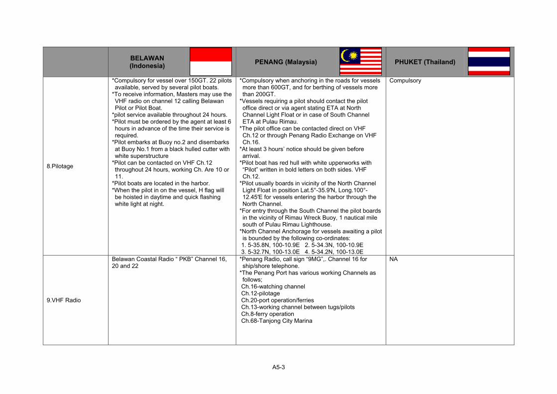
A5-3
BELAWAN (Indonesia) PENANG (Malaysia) PHUKET (Thailand)
8.Pilotage
*Compulsory for vessel over 150GT. 22 pilots available, served by several pilot boats.
*To receive information, Masters may use the VHF radio on channel 12 calling Belawan Pilot or Pilot Boat.
*pilot service available throughout 24 hours. *Pilot must be ordered by the agent at least 6 hours in advance of the time their service is required.
*Pilot embarks at Buoy no.2 and disembarks at Buoy No.1 from a black hulled cutter with white superstructure
*Pilot can be contacted on VHF Ch.12 throughout 24 hours, working Ch. Are 10 or 11.
*Pilot boats are located in the harbor. *When the pilot in on the vessel, H flag will be hoisted in daytime and quick flashing white light at night.
*Compulsory when anchoring in the roads for vessels more than 600GT, and for berthing of vessels more than 200GT.
*Vessels requiring a pilot should contact the pilot office direct or via agent stating ETA at North Channel Light Float or in case of South Channel ETA at Pulau Rimau.
*The pilot office can be contacted direct on VHF Ch.12 or through Penang Radio Exchange on VHF Ch.16.
*At least 3 hours’ notice should be given before arrival.
*Pilot boat has red hull with white upperworks with “Pilot” written in bold letters on both sides. VHF Ch.12.
*Pilot usually boards in vicinity of the North Channel Light Float in position Lat.5°-35.9′N, Long.100°-12.45′E for vessels entering the harbor through the North Channel.
*For entry through the South Channel the pilot boards in the vicinity of Rimau Wreck Buoy, 1 nautical mile south of Pulau Rimau Lighthouse.
*North Channel Anchorage for vessels awaiting a pilot is bounded by the following co-ordinates:
1. 5-35.8N, 100-10.9E 2. 5-34.3N, 100-10.9E 3. 5-32.7N, 100-13.0E 4. 5-34.2N, 100-13.0E
Compulsory
9.VHF Radio
Belawan Coastal Radio “ PKB” Channel 16, 20 and 22
*Penang Radio, call sign “9MG”,. Channel 16 for ship/shore telephone.
*The Penang Port has various working Channels as follows;
Ch.16-watching channel Ch.12-pilotage Ch.20-port operation/ferries Ch.13-working channel between tugs/pilots Ch.8-ferry operation Ch.68-Tanjong City Marina
NA

A5-4
BELAWAN (Indonesia) PENANG (Malaysia) PHUKET (Thailand)
10.Weather/Tides
*Heaviest rainfall in September, and lowest in February, this does affect river levels.
*River levels are highest between September to December and lowest January to April.
*Visibility can be reduced to less than 1 nautical mile during period of fog, usually experienced between September and October.
*June is warmest with an average temperature of 32.7 °C at noon. January is coldest with an average temperature of 21.6 °C at night. Belawan has no distinct temperature seasons, the temperature is relatively constant during the year. The temperatures at night are cooler than during daytime. July is on average the month with most sunshine. Rainfall and other precipitation peaks around November. The time around June is driest
*Current: Influenced by the Belawan and Deli Rivers, Malacca Straits weather conditions. During spring tides the current in the entrance channel can reach 2 knots and up to 3 knots outside.
*Tide Range: about 2.0m
*March is warmest with an average temperature of 33.2 °C at noon. January is coldest with an average temperature of 22.5 °C at night. George Town has no distinct temperature seasons, the temperature is relatively constant during the year. The temperatures at night are cooler than during daytime. September is on average the month with most sunshine. Rainfall and other precipitation peaks around October. The time around February is driest.
*NE monsoon season: From November through March, periods
of strong easterly winds. *SW monsoon season: Prevailing from April through October, periods of strong westerly winds.
*March is warmest with an average temperature of 33.1 °C at noon. January is coldest with an average temperature of 23 °C at night. Phuket has no distinct temperature seasons, the temperature is relatively constant during the year. The temperatures at night are cooler than during daytime. September is on average the month with most sunshine. The wet season has a rainfall peak around September, the dry season is around the month of February.
*Tide Range:
11.Restrictions
*Berthing and unberthing are throughout 24 hours. *Bar is silting excessively and continuous dredging work is necessary to keep the shallowest part at 8.0m (LWS).
*Berthing and unberthing are throughout 24 hours. *Dredging work of the North Channel has been conducted through 2010-2011 from11.5m to 14.0m
*Entering or leaving through the north channel involves a rather sharp turn with a radius of about 305m and angle of about 115° between the axis of channel in a restricted area between Buoy No.6 and koh Tapai Noi island. Pay attention to the wreck buoy between Buy No.6 and Koh Tapao Noi.
*The draft at Buoy No.6 is about 7.5m at Lowest HW.
*The width between the narrowest pair of mooring buoys at Buoy No.5 is about 46m and vessels are required to pass clear between these mooring buoys.

A5-5
BELAWAN (Indonesia) PENANG (Malaysia) PHUKET (Thailand)
12.Max Acceptable Ship’s Size
LOA 200m, Draft 9.5m 50,000DWT、Draft 14.0m *New Port: Depth 10.0m *Old Port: 10,000DWT, LOA 131m
13.Summary
(1)Distance between Belawan and Penang : 140 nautical miles Distance between Belawan and Phuket : 242 nautical miles (2)Maximum Ship’s Size which can be assigned both Belawan & Penang ; Approx.30,000DWT, LOA 200m, Draft 9.5m Maximum Ship’s Size which can be assigned both Belawan & Phuket ; Approx.30,000DWT, LOA 200m, Draft 9.0m

ANNEX TO CHAPTER 6

A6-1
Annex 6.1 Hard and Soft Conditions of Dumai – Malacca Route
DUMAI (Indonesia) MALACCA (Malaysia)
1.Overview Sea port with good shelter. There are six berths a total 885m long, handling crude oil, palm oil, general cargoes, fertilizers, rice and international and domestic passengers
Small port located in an open-sea area, handling bulk, breakbulk and bulk liquid.
2.Location 1° 41••N 101° 27••ELocated on the north central shores of Sumatra island facing Malacca Strait.
2° 13••N 102° 09••ELocated in southern part of the Malay Peninsula on the Malacca Strait. 12km west of Malacca City centre, 23minutes by car.
3.Nautical Charts BA Chart No.795 (Cape Rachado to Singapore) Malaysian Chart No.5217 BA Chart No. 1141, 3946, 3947
4.Sea Access to the Port
The Dumai port installations can be reached by deep draft vessels by proceeding from Malacca Strait into Bengkalis and following a buoyed channel on a Southerly course of 22 miles to the junction of the Rupat Strait.Vessel must make a turn of approximately 180°to enter the Rupat Strait and thence Westerly for a distance of 33 miles to Dumai.
Freely accessible from all directions of sea
5.PortChannel
a)Distance 33 nautical miles No channel existing b)Width Wide enough for VLCC c)Depth 24m and 18.3m (LWS)
6.Port Basin
7.0m – 18.6m depend on the terminal T-shape jetty Length 170m (approx.12,000DWT) Depth of water: Seaward side 9m Inner side 5m Connecting Bridge 400m
7.Anchorage
*The Dumai general anchorage area is north and west of the wharves. *Minimum depth of water in this area 13.1m.; 10.67m shoal spot to east of the general anchorage should be noticed.
*Holding ground in anchorages considered good, bottom clay. Area large with sufficient maneuvering and swinging room for several vessels of size to be accommodated at oil wharves.
*If vessels are not met by the pilot’s launch on arrival, or not instructed by Dumai Port Control Radio to berth on arrival, it is suggested that they proceed to the recommended anchorage area.
*Located approximately 1-1.5 nautical mile off the mouth of the Malacca River and Tanjung Bruas Jetty, depth of water 4.87-9.75m.
*Anchoring is prohibited within 1 mile of Tanjung Bruas Jetty.
8.Pilotage
*Compulsory for vessels more than 105GT. *Harbor pilotage is performed by government pilots. *Harbor pilot will board a vessel at the anchorage for berthing or immediately on arrival at buoy No.18 when berth is available.
*Compulsory for vessels entering or leaving port limits and during berthing/unberthing.
*Vessels to give Malacca Port Authority 12 hours prior notice. *Vessels from west take pilot 2.75 miles WSW of Tanjung Kling

A6-2
DUMAI (Indonesia) MALACCA (Malaysia)
*Sea piloting for the Rupat Strait and Bengkalis Strait is provided by the department of Sea Communication.
*Sea pilot boarding areas as follows; (1)Bengkalis Strait and Rupat Strait from Fairway buoy or eastern
part of Morong Strait to eastern limit of Dumai harbor pilot area(Long.101°-30••E)
(2)Rupat Strait and Nengkalis Strait from eastern limit to Dumai Harbor pilot area (Long.101° 30••E) to northern limit of Sungai Pakning harbor pilot area.
*Six hours prior to arrival Dumai harbor area, all vessels should contact CPI through VHF Ch.10 or 16 and 69.
*At Fairway Buoy all vessels should hoist international code flag “H” and contact Morong Pilot station via Ch.16 for requesting pilot.
and vessels from east take pilot 5 miles SSW of Tanjung Kling. *Pilot on VHF Ch.12 and 16.
9.VHF Radio CPI radio operates through 24 hours and is available for information concerning vessel’s port activities, listening on Ch.16 and operating on Ch.10 and 69.
VHF Ch.16 & 12 for pilot
10.Weather/Tides
*Winds: NE monsoon is never very steady but is most constant in January when from 20-40% of wind are NE. In November and December NE winds are most frequent. In February the most frequent winds are NE. SW monsoon begins in late May or early June. From June to September winds in the straits are mainly SE but not steady. At this season squalls known as “Sumatra’s” occur off the coast; they are most frequent between 2200-0200 hrs.
*Rains: Rainfall is heavy with yearly average from80-100 inch. The wettest months are October to December or January. There are two comparatively dry seasons, February to March and June to August. The most intense rain falls are in the afternoon but these heavy downpours are often short in duration. The duration of the rain is more evenly spread over 24 hours during the NE monsoon than during the rest of the year when rain most likely occurs in the evening and night.
*Temperature: Average temperature is a little below 80°F. The range in an average year is only 30°F, between 65°F and 95°F. The daily range is from 15-20°F. The humidity is high(70-90%).
*Tides & Current: The tide rise is approximately 2.43m in the springs and approximately 1.52m at neaps. Max tide currents is easterly 3 knots(flooding), westerly at 2 knots(ebbing). The general direction of the current is parallel to the faces of the wharves. There is no slack
*Monsoonal similar to Dumai. *Wind: Prevailing SW’ly and NE’ly monsoons. Occasional strong NW wind during 3rd/4th quarter of the year, lasting3-4 days.
*March is warmest with an average temperature of 32.9 °C at noon. July is coldest with an average temperature of 22.4 °C at night. Melaka has no distinct temperature seasons, the temperature is relatively constant during the year. The temperatures at night are cooler than during daytime. March is on average the month with most sunshine. Rainfall and other precipitation peaks around November. The time around June is driest.
*Tidal range 2.0m

A6-3
DUMAI (Indonesia) MALACCA (Malaysia)
current in the Rupat Strait during spring tides and only a very brief period of slack current during neap tides. The current reverses its direction almost immediately. Vessels will always be berthed stemming the current flow.
11.Restrictions
*Requirement for entering Restricted Maritime Zone of Sumatra.: For some years, the Rupat-Bengkalis Strait area has been designated a Restricted Maritime Zone by decree of the Government of Indonesia. A partial exemption from the requirement to secure special Indonesian Consular Clearance before entering this Zone has been granted by the Indonesian Navy to tanker vessels proceeding to Dumai from any port in the world except Singapore. Vessels require only normal clearances from their last port to obtain entry at Dumai. Vessels diverted at sea need only normal clearance from last port and the diversion cable. All vessels inbound to Dumai from the time abreast Raleigh Bank Light Buoy until anchored off Dumai Terminal must display the following recognized signals;
By day: The international code flag hoist “CAL” flown a single hoist from the signal yard.
By night: A red light 1.83m above a white light both visible all around the horizon at a distance of not less than 2 miles.
Vessel should be prepared to answer identification queries from Indonesian Naval Patrol Craft.
None
12.Max Acceptable Ship’s Size
LOA 315m, Draft 17.7m Vessels over 315m should have and obtain special guidance and permission from Harbor Master.
T-Shape Jetty can accommodate one vessel LOA 150m (approx. 12,000DWT) on the seaward side, depth of water 9.0m, at any time. And one vessel LOA 70m on the inner side, depth of water 5m, at any time
13.Summary (1)Distance between Dumai and Malacca : 58 nautical miles (2)Maximum Ship’s Size which can be assigned both Dumai & Malacca ; Approx. 12,000DWT, LOA 150m, Draft 8.0m

ANNEX TO CHAPTER 7

A7-1
Annex 7.1 Hard and Soft Conditions of Muara – Labuan – Brooke’s Point and Muara – Zamboanga Routes
Hard and Soft Conditions of Muara – Labuan – Brooke’s Point Route
MUARA
(Brunei Darussalam)LABUAN
(Malaysia)BROOKE’S POINT
(Philippines)
1.Overview Port handles containers, RO-RO, livestock, Passengers, general cargo and bulk bitumen and cement
A naturally sheltered port offering facilities for various cargoes.
Major commodities handled at the port are consumer goods, construction materials, and products of agricultural and mining industries.
2.Location
5° 01••N 115° 04••EOn the west coast of Brunei Darussalam, facing Pulau Muara Besar.
5° 17••N 115° 15••E*The island of Labuan is 19km long and 11kmwide, lying off NW coast of Borneo at entrance to Brunei Bay.
*The Malaysian state of Sabah is 4.5 miles to the east and the state capital Kota Kinabalu is 124km to the NE.
*SBM for Crude oil located to the SW of the island.
8° 47••N 117° 49.1••E*The port of Brooke’s Point lies in the southern part of mainland Palawan and 192km south of Puerto Princesa.
*Port linkages include Cagayan de Tawi-Tawi, General Santos, Dipolog, Balabac, Puerto Princa,and Manila
3.Nautical Charts BA Chart No.1338, 2109 BA Chart No. 947, 1844, 2109, 2111
4.Sea Access to the Port
Training banks were constructed 2,012m long on the western side of the entrance channel and 457m long on the eastern side. These banks are built of sand and stone rubber topped with large blocks of stone weighing up to 4 tonnes each. Both banks slope downward as they proceed from Tanjung Pelompong Spit into South China Sea.
5.Port Channel Main entrance channel dredged to 12.5m (CD), length 2,651m, width 122m at the seabet.
Entrance channel starts three miles northeast from lighthouse to avoid Channel coral reef.
6.Port Basin
Main Berth:Maximum depth 13.5m RO-RO berth: depth 6-10m
*The berthing area is quite shallow that only barges with shallow draft can be accommodated at berth.
*Vessel with deeper draft may occupy and drop anchor at a distance of 400m from the rock
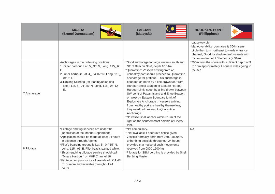
A7-2
MUARA
(Brunei Darussalam)LABUAN
(Malaysia)BROOKE’S POINT
(Philippines)
causeway pier. *Maneuverability room area is 300m semi-circle then turn northeast towards entrance channel, Good for shallow draft vessels with minimum draft of 1.3 fathoms (2.34m)
7.Anchorage
Anchorages in the following positions: 1. Outer harbour: Lat. 5_ 35' N, Long. 115_ 6' E2. Inner harbour: Lat. 4_ 54' 07" N, Long. 115_
04' 6" E 3.Tanjong Selirong (for loading/unloading
logs): Lat. 5_ 01' 36" N, Long. 115_ 04' 12" E.
*Good anchorage for large vessels south and SE of Beacon No.6, depth 10.51m
*Quarantine: Vessels arriving from an unhealthy port should proceed to Quarantine anchorage for pratique. This anchorage is bounded on north by a line drawn 090°from Harbour Shoal Beacon to Eastern Harbour Harbour Limit; south by a line drawn between SW point of Papan Island and Enoe Beacon: on west by Eastern Boundary Limit of Explosives Anchorage .If vessels arriving from healthy port are healthy themselves, they need not proceed to Quarantine Anchorage.
*No vessel shall anchor within 610m of the light on the southernmost dolphin of Liberty Pier.
*700m from the shore with sufficient depth of 9 to 10m approximately 4 square miles going to the sea.
8.Pilotage
*Pilotage and tug services are under the jurisdiction of the Marine Department.
*Application should be made at least 24 hours in advance through Agents.
*Pilot’s boarding ground is Lat. 5_ 04' 15" N, Long. 115_ 06' E. Pilot boat is painted white.
*Ships requiring pilotage service should call ‘‘Muara Harbour’’ on VHF Channel 16
*Pilotage compulsory for all vessels of LOA 46 m. or more and available throughout 24 hours.
*Not compulsory. *Pilot available if adequate notice given. *Vessels normally berth from 0600-1800hrs, unberthing possible throughout 24 hours, provided that notice of such movements received from 0800-1600 hrs.
*Pilotage for SBM berthing is provided by Shell Berthing Master.
NA
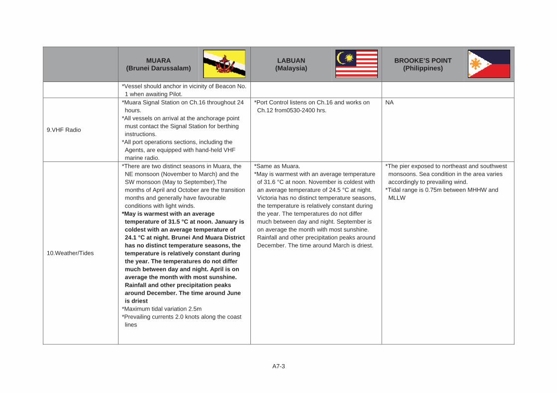
A7-3
MUARA
(Brunei Darussalam)LABUAN
(Malaysia)BROOKE’S POINT
(Philippines)
*Vessel should anchor in vicinity of Beacon No. 1 when awaiting Pilot.
9.VHF Radio
*Muara Signal Station on Ch.16 throughout 24 hours.
*All vessels on arrival at the anchorage point must contact the Signal Station for berthing instructions.
*All port operations sections, including the Agents, are equipped with hand-held VHF marine radio.
*Port Control listens on Ch.16 and works on Ch.12 from0530-2400 hrs.
NA
10.Weather/Tides
*There are two distinct seasons in Muara, the NE monsoon (November to March) and the SW monsoon (May to September).The months of April and October are the transition months and generally have favourable conditions with light winds.
*May is warmest with an average temperature of 31.5 °C at noon. January is coldest with an average temperature of 24.1 °C at night. Brunei And Muara District has no distinct temperature seasons, the temperature is relatively constant during the year. The temperatures do not differ much between day and night. April is on average the month with most sunshine. Rainfall and other precipitation peaks around December. The time around June is driest
*Maximum tidal variation 2.5m *Prevailing currents 2.0 knots along the coast lines
*Same as Muara. *May is warmest with an average temperature of 31.6 °C at noon. November is coldest with an average temperature of 24.5 °C at night. Victoria has no distinct temperature seasons, the temperature is relatively constant during the year. The temperatures do not differ much between day and night. September is on average the month with most sunshine. Rainfall and other precipitation peaks around December. The time around March is driest.
*The pier exposed to northeast and southwest monsoons. Sea condition in the area varies accordingly to prevailing wind.
*Tidal range is 0.75m between MHHW and MLLW
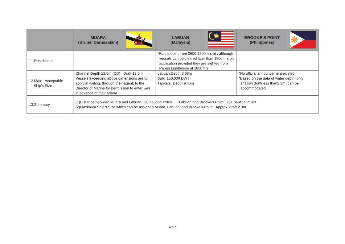
A7-4
MUARA
(Brunei Darussalam)LABUAN
(Malaysia)BROOKE’S POINT
(Philippines)
11.Restrictions
*Port is open from 0600-1800 hrs at , although vessels can be cleared later than 1800 hrs on application provided they are sighted from Papan Lighthouse at 1800 hrs.
12.Max Acceptable Ship’s Size
Channel Depth 12.5m (CD) Draft 12.5m Vessels exceeding above dimensions are to apply in writing, through their agent, to the Director of Marine for permission to enter well in advance of their arrival.
Labuan:Depth 8.68m Bulk: 150,000 DWT Tankers: Depth 9.45m
*No official announcement existed *Based on the data of water depth, only shallow draft(less than2.3m) can be accommodated
13.Summary (1)Distance between Muara and Labuan : 20 nautical miles Labuan and Brooke’s Point : 261 nautical miles (2)Maximum Ship’s Size which can be assigned Muara, Labuan, and Brooke’s Point : Approx. draft 2.3m

A7-5
Hard and Soft Conditions of Muara – Zamboanga Route
MUARA (Brunei Darussalam)
ZAMBOANGA (Philippines)
1.Overview
Port handles containers, RO-RO, livestock, Passengers, general cargo and bulk bitumen and cement
The multipurpose Port of Zamboanga consists of a number of ports, all contained by the Zamboanga City Special Economic Zone Authority (Zamboecozone), otherwise known by its corporate name as the Zamboanga Freeport Authority (ZFA).
2.Location 5° 01••N 115° 04••EOn the west coast of Brunei Darussalam, facing Pulau Muara Besar.
6° 54••N 122 04••EOn the southern tip of Western Mindanao Peninsula.
3.Nautical Charts BA Chart No.1338, 2109 BA Chart No.927, 928, 3811
4.Sea Access to the Port
Training banks were constructed 2,012m long on the western side of the entrance channel and 457m long on the eastern side. These banks are built of sand and stone rubber topped with large blocks of stone weighing up to 4 tonnes each. Both banks slope downward as they proceed from Tanjung Pelompong Spit into South China Sea.
5.Port Channel Main entrance channel dredged to 12.5m (CD), length 2,651m, width 122m at the seabet.
Vessels approach the port from the west via Caldera Bay, from the south via the Isabela Channel and from the east via the Tictaoan Channel.
6.Port Basin Main Berth:Maximum depth 13.5m RO-RO berth: depth 6-10m
Depth of water 5-12m depends on the terminal.
7.Anchorage
Anchorages in the following positions: 1. Outer harbour: Lat. 5_ 35' N, Long. 115_ 6' E 2. Inner harbour: Lat. 4_ 54' 07" N, Long. 115_ 04' 6" E 3.Tanjong Selirong (for loading/unloading logs): Lat. 5_ 01' 36" N,
Long. 115_ 04' 12" E.
*Owing to the steep bank, strong currents and hard, uneven bottom, there are no good anchorages off Zamboanga.
*However, anchorage may be made anywhere southward of the wharf at a distance of about 3 cables offshore eastward of an imaginary line from the tide indicator, at a depth of 45-50m with 192m chain in the water. This will hold vessel even at strongest current of 6 knots.
*In the event of very bad weather, the vessel should transfer anchorage to Caldera Bay, which is approximately 7 miles west of the anchorage area.
8.Pilotage
*Pilotage and tug services are under the jurisdiction of the Marine Department.
*Application should be made at least 24 hours in advance through Agents.
*Pilot’s boarding ground is Lat. 5_ 04' 15" N, Long. 115_ 06' E. Pilot
*Compulsory for foreign-going vessels and domestic trade vessels over 500GT 24-hours’ notice required.
*Vessels approaching the port use international code signals for calling pilot.
*Pilot station operational throughout 24 hours.
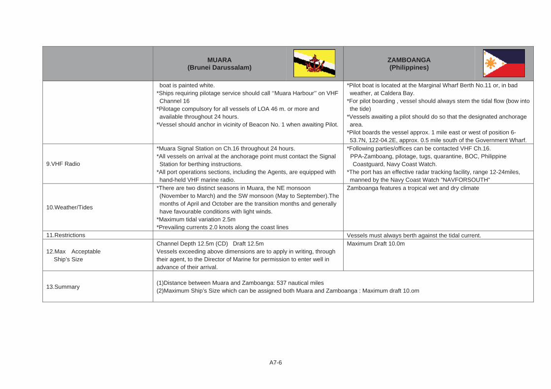
A7-6
MUARA (Brunei Darussalam)
ZAMBOANGA (Philippines)
boat is painted white. *Ships requiring pilotage service should call ‘‘Muara Harbour’’ on VHF Channel 16
*Pilotage compulsory for all vessels of LOA 46 m. or more and available throughout 24 hours.
*Vessel should anchor in vicinity of Beacon No. 1 when awaiting Pilot.
*Pilot boat is located at the Marginal Wharf Berth No.11 or, in bad weather, at Caldera Bay.
*For pilot boarding , vessel should always stem the tidal flow (bow into the tide)
*Vessels awaiting a pilot should do so that the designated anchorage area.
*Pilot boards the vessel approx. 1 mile east or west of position 6-53.7N, 122-04.2E, approx. 0.5 mile south of the Government Wharf.
9.VHF Radio
*Muara Signal Station on Ch.16 throughout 24 hours. *All vessels on arrival at the anchorage point must contact the Signal Station for berthing instructions.
*All port operations sections, including the Agents, are equipped with hand-held VHF marine radio.
*Following parties/offices can be contacted VHF Ch.16. PPA-Zamboang, pilotage, tugs, quarantine, BOC, Philippine
Coastguard, Navy Coast Watch. *The port has an effective radar tracking facility, range 12-24miles, manned by the Navy Coast Watch ”NAVFORSOUTH”
10.Weather/Tides
*There are two distinct seasons in Muara, the NE monsoon (November to March) and the SW monsoon (May to September).The months of April and October are the transition months and generally have favourable conditions with light winds.
*Maximum tidal variation 2.5m *Prevailing currents 2.0 knots along the coast lines
Zamboanga features a tropical wet and dry climate
11.Restrictions Vessels must always berth against the tidal current.
12.Max Acceptable Ship’s Size
Channel Depth 12.5m (CD) Draft 12.5m Vessels exceeding above dimensions are to apply in writing, through their agent, to the Director of Marine for permission to enter well in advance of their arrival.
Maximum Draft 10.0m
13.Summary (1)Distance between Muara and Zamboanga: 537 nautical miles (2)Maximum Ship’s Size which can be assigned both Muara and Zamboanga : Maximum draft 10.om

ANNEX TO CHAPTER 8
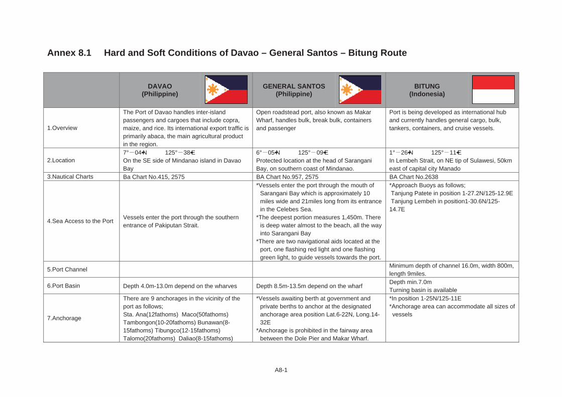
A8-1
Annex 8.1 Hard and Soft Conditions of Davao – General Santos – Bitung Route
DAVAO (Philippine)
GENERAL SANTOS (Philippine)
BITUNG (Indonesia)
1.Overview
The Port of Davao handles inter-island passengers and cargoes that include copra, maize, and rice. Its international export traffic is primarily abaca, the main agricultural product in the region.
Open roadstead port, also known as Makar Wharf, handles bulk, break bulk, containers and passenger
Port is being developed as international hub and currently handles general cargo, bulk, tankers, containers, and cruise vessels.
2.Location 7° 04••N 125° 38••EOn the SE side of Mindanao island in Davao Bay
6° 05••N 125° 09••EProtected location at the head of Sarangani Bay, on southern coast of Mindanao.
1° 26••N 125° 11••EIn Lembeh Strait, on NE tip of Sulawesi, 50km east of capital city Manado
3.Nautical Charts Ba Chart No.415, 2575 BA Chart No.957, 2575 BA Chart No.2638
4.Sea Access to the Port Vessels enter the port through the southern entrance of Pakiputan Strait.
*Vessels enter the port through the mouth of Sarangani Bay which is approximately 10 miles wide and 21miles long from its entrance in the Celebes Sea.
*The deepest portion measures 1,450m. There is deep water almost to the beach, all the way into Sarangani Bay
*There are two navigational aids located at the port, one flashing red light and one flashing green light, to guide vessels towards the port.
*Approach Buoys as follows; Tanjung Patete in position 1-27.2N/125-12.9E Tanjung Lembeh in position1-30.6N/125-14.7E
5.Port Channel Minimum depth of channel 16.0m, width 800m, length 9miles.
6.Port Basin Depth 4.0m-13.0m depend on the wharves Depth 8.5m-13.5m depend on the wharf Depth min.7.0m Turning basin is available
7.Anchorage
There are 9 anchorages in the vicinity of the port as follows; Sta. Ana(12fathoms) Maco(50fathoms) Tambongon(10-20fathoms) Bunawan(8-15fathoms) Tibungco(12-15fathoms) Talomo(20fathoms) Daliao(8-15fathoms)
*Vessels awaiting berth at government and private berths to anchor at the designated anchorage area position Lat.6-22N, Long.14-32E
*Anchorage is prohibited in the fairway area between the Dole Pier and Makar Wharf.
*In position 1-25N/125-11E *Anchorage area can accommodate all sizes of vessels
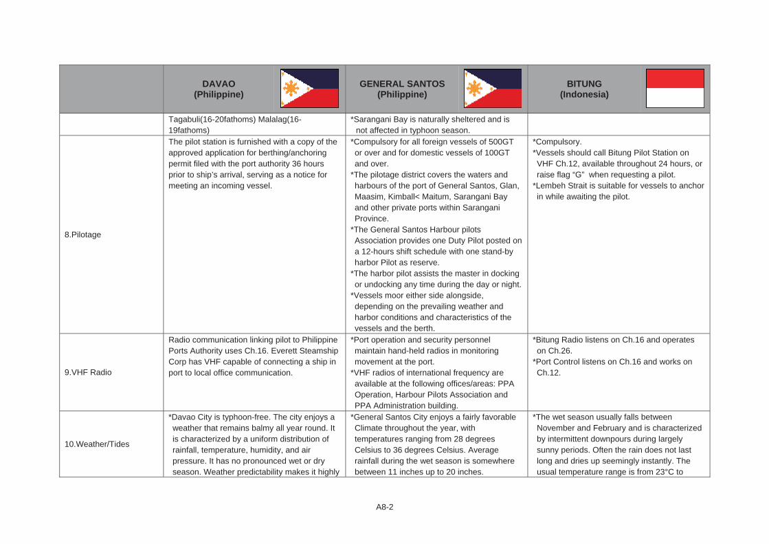
A8-2
DAVAO (Philippine)
GENERAL SANTOS (Philippine)
BITUNG (Indonesia)
Tagabuli(16-20fathoms) Malalag(16-19fathoms)
*Sarangani Bay is naturally sheltered and is not affected in typhoon season.
8.Pilotage
The pilot station is furnished with a copy of the approved application for berthing/anchoring permit filed with the port authority 36 hours prior to ship’s arrival, serving as a notice for meeting an incoming vessel.
*Compulsory for all foreign vessels of 500GT or over and for domestic vessels of 100GT and over.
*The pilotage district covers the waters and harbours of the port of General Santos, Glan, Maasim, Kimball< Maitum, Sarangani Bay and other private ports within Sarangani Province.
*The General Santos Harbour pilots Association provides one Duty Pilot posted on a 12-hours shift schedule with one stand-by harbor Pilot as reserve.
*The harbor pilot assists the master in docking or undocking any time during the day or night.
*Vessels moor either side alongside, depending on the prevailing weather and harbor conditions and characteristics of the vessels and the berth.
*Compulsory. *Vessels should call Bitung Pilot Station on VHF Ch.12, available throughout 24 hours, or raise flag “G” when requesting a pilot.
*Lembeh Strait is suitable for vessels to anchor in while awaiting the pilot.
9.VHF Radio
Radio communication linking pilot to Philippine Ports Authority uses Ch.16. Everett Steamship Corp has VHF capable of connecting a ship in port to local office communication.
*Port operation and security personnel maintain hand-held radios in monitoring movement at the port.
*VHF radios of international frequency are available at the following offices/areas: PPA Operation, Harbour Pilots Association and PPA Administration building.
*Bitung Radio listens on Ch.16 and operates on Ch.26.
*Port Control listens on Ch.16 and works on Ch.12.
10.Weather/Tides
*Davao City is typhoon-free. The city enjoys a weather that remains balmy all year round. It is characterized by a uniform distribution of rainfall, temperature, humidity, and air pressure. It has no pronounced wet or dry season. Weather predictability makes it highly
*General Santos City enjoys a fairly favorable Climate throughout the year, with temperatures ranging from 28 degrees Celsius to 36 degrees Celsius. Average rainfall during the wet season is somewhere between 11 inches up to 20 inches.
*The wet season usually falls between November and February and is characterized by intermittent downpours during largely sunny periods. Often the rain does not last long and dries up seemingly instantly. The usual temperature range is from 23°C to
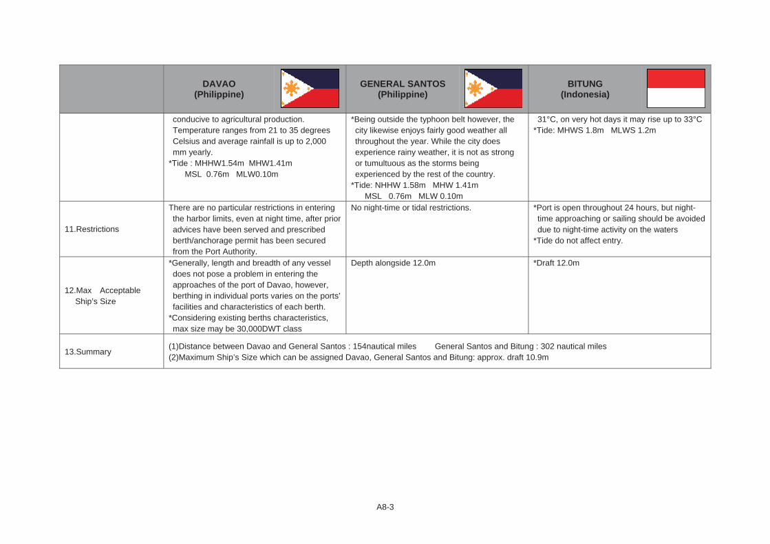
A8-3
DAVAO (Philippine)
GENERAL SANTOS (Philippine)
BITUNG (Indonesia)
conducive to agricultural production. Temperature ranges from 21 to 35 degrees Celsius and average rainfall is up to 2,000 mm yearly.
*Tide : MHHW1.54m MHW1.41m MSL 0.76m MLW0.10m
*Being outside the typhoon belt however, the city likewise enjoys fairly good weather all throughout the year. While the city does experience rainy weather, it is not as strong or tumultuous as the storms being experienced by the rest of the country.
*Tide: NHHW 1.58m MHW 1.41m MSL 0.76m MLW 0.10m
31°C, on very hot days it may rise up to 33°C *Tide: MHWS 1.8m MLWS 1.2m
11.Restrictions
There are no particular restrictions in entering the harbor limits, even at night time, after prior advices have been served and prescribed berth/anchorage permit has been secured from the Port Authority.
No night-time or tidal restrictions. *Port is open throughout 24 hours, but night-time approaching or sailing should be avoided due to night-time activity on the waters
*Tide do not affect entry.
12.Max Acceptable Ship’s Size
*Generally, length and breadth of any vessel does not pose a problem in entering the approaches of the port of Davao, however, berthing in individual ports varies on the ports’ facilities and characteristics of each berth.
*Considering existing berths characteristics, max size may be 30,000DWT class
Depth alongside 12.0m *Draft 12.0m
13.Summary (1)Distance between Davao and General Santos : 154nautical miles General Santos and Bitung : 302 nautical miles (2)Maximum Ship’s Size which can be assigned Davao, General Santos and Bitung: approx. draft 10.9m

ANNEX TO CHAPTER 9

A9-1
Annex 9.1 Hard and Soft Conditions of Johor – Sintete and Tawau – Tarakan – Pantoloan Routes Hard and Soft Conditions of Johor – Sintete Route
JOHOR(Malaysia)
SINTETE(Indonesia)
1.Overview
Johor Port is strategically positioned in the heart of the sprawling 8,000 acre Pasir Gudang Industrial Estate. The area is home to a comprehensive range of industries specializing in petrochemicals, engineering, furniture, telecommunications, electronic goods and food products among others.
Sintete port belongs to Sintete Port Administration Office and it is River Port. Port of Sintete 's size is small
2.Location
1° 26••N 103° 54••EJohor Port at Pasir Gudang, Johor, is located at the southern tip of Peninsular Malaysia, on the eastern shoreline of the Johor Strait, approximately 20 miles east of Johor Maru., the capital city.
1° 14.4••N 109° 08.5E *Sintete port is located in West Kalimantan, 5 hours from Pontianak City by car.
*Near of Sintete approximately 35 km, there are several regencies such as Singkawang, Pemangkat, and Sambas as hinterland area.
3.Nautical Charts BA Chart No.2585, 2586 4.Sea Access to the Port
5.Port Channel
There is no limitation imposed on size of vessels passing through the fairway except for the draft. The main channel in the east Johor Strait has a depth of water up to approximately 12.4 m up to the port waterfront and 11.4m up to Sembawang Shipyard and 10.9m up to the causeway.
*The distance from Sambas river mouth to the port is approximately 6 miles.
*Current channel depth is 4.5m(LWS) and width is 50m *1.5 miles of critical channel is existed in the Sambas river.
6.Port Basin Depth 6.0m -15.0m depend on the berth Depth 8m(maximum)
7.Anchorage
Anchorage areas have been designated within the port water limits and indicated in all navigational charts for the following; a)general purposes b)dangerous goods and explosives c)quarantine d)petroleum e)lay-up
8.Pilotage
*Compulsory for vessels either exceeding 45m in length and/or with height structure above 30m or without any radio communication on board, entering or leaving the port limits.
*Johor port provides round-the-clock pilotage services. *The pilot boarding point is at 1 18.9N, 104 7.2E, with Tanjung Stapa light beacon bearing 033°(T) ×1.95 miles.
*ETA to be sent to Harbor Master 24 hours prior to arrival, and to
NA

A9-2
JOHOR(Malaysia)
SINTETE(Indonesia)
“Johor port Control” 3 hours prior to arrival or departure.
9.VHF Radio
*Vessels can communicate with the pilot control station tower (call sign “Johor port Control” by VHF Ch.11, 63 and 68.
*VHF network links the tugs, launches and the port personnel working on board vessels at the anchorage.
NA
10.Weather/Tides
*Johor has a tropical rainforest climate with monsoon rain from November until February blowing from the South China Sea.
*The average annual rainfall is 1778 mm with average temperatures ranging between 25.5 °C (78 °F) and 27.8 °C (82 °F). Humidity is between 82 and 86%.
*April is warmest with an average temperature of 31.7 °C at noon. January is coldest with an average temperature of 22 °C at night. Johor Bahru has no distinct temperature seasons, the temperature is relatively constant during the year. The temperatures do not differ much between day and night. April is on average the month with most sunshine. Rainfall and other precipitation have no distinct peak month.
*Tide: Range of tide is 3.0m. Minimum 0.5m Maximum 3.5m
*August is warmest with an average temperature of 32 °C at noon. August is coldest with an average temperature of 22.6 °C at night. Sintete has no distinct temperature seasons, the temperature is relatively constant during the year. The temperatures at night are cooler than during daytime. September is on average the month with most sunshine. Rainfall and other precipitation peaks around December. The time around July is driest.
*Tide Range 1.2m
11.Restrictions
*24 Hours pilotage service for all vessels entering or leaving Johor Port is provided.
*However, the following restrictions are imposed; Recommended Speed, Reporting, Tugs, and others
River navigation and poor port facilities, only small size vessels can be accommodated.
12.Max Acceptable Ship’s Size
Bulk: 60,000DWT, Depth 11.0m Containers: 104,000DWT, Depth 15.0m Dry Cargo: 30,000DWT, Depth 11.0m Tankers: 90,000DWT, Depth 13.0m
Considering the depth of water and port facilities, maximum acceptable size of vessel is less than 1,000GT.
13.Summary (1)Distance between Johor and Sintete : 321 nautical miles (2)Maximum Ship’s Size which can be assigned Johor and Sintete : Approx. 1,000GT
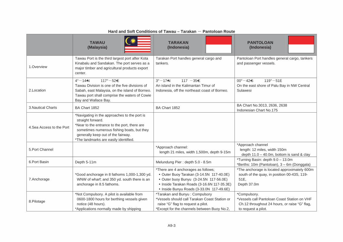
A9-3
Hard and Soft Conditions of Tawau – Tarakan Pantoloan Route
TAWAU (Malaysia)
TARAKAN (Indonesia)
PANTOLOAN (Indonesia)
1.Overview
Tawau Port is the third largest port after Kota Kinabalu and Sandakan. The port serves as a major timber and agricultural products export center.
Tarakan Port handles general cargo and tankers.
Pantoloan Port handles general cargo, tankers and passenger vessels.
2.Location
4° 14••N 117° 52••ETawau Division is one of the five divisions of Sabah, east Malaysia, on the island of Borneo. Tawau port shall comprise the waters of Cowie Bay and Wallace Bay.
3° 17••N 117� 35••EAn island in the Kalimantan Timur of Indonesia, off the northeast coast of Borneo.
00° 42••S 119° 51E On the east shore of Palu Bay in NW Central Sulawesi
3.Nautical Charts BA Chart 1852 BA Chart 1852 BA Chart No.3013, 2636, 2638 Indonesian Chart No.175
4.Sea Access to the Port
*Navigating in the approaches to the port is straight forward.
*Near to the entrance to the port, there are sometimes numerous fishing boats, but they generally keep out of the fairway.
*The landmarks are easily identified.
5.Port Channel *Approach channel: length 21 miles, width 1,500m, depth 9-15m
*Approach channel length: 12 miles, width 150m
depth 11.0 – 40.0m, bottom is sand & clay
6.Port Basin Depth 5-11m Melundung Pier : depth 5.0 - 8.5m *Turning Basin: depth 9.0 – 13.0m *Berths: 10m (Pantoloan), 3 – 6m (Donggala)
7.Anchorage *Good anchorage in 8 fathoms 1,000-1,300 yd. WNW of wharf; and 350 yd. south there is an anchorage in 8.5 fathoms.
*There are 4 anchorages as follows; Outer Buoy Tarakan (3-14.5N 117-40.0E) Outer buoy Bunyu (3-24.5N 117-56.0E) Inside Tarakan Roads (3-16.6N 117-35.3E) Inside Bunyu Roads (3-33.0N 117-49.6E)
*The anchorage is located approximately 600m south of the quay, in position 00-43S, 119-51E,
Depth 37.0m
8.Pilotage
*Not Compulsory. A pilot is available from 0600-1800 hours for berthing vessels given notice (48 hours).
*Applications normally made by shipping
*Tarakan and Bunyu : Compulsory *Vessels should call Tarakan Coast Station or raise “G” flag to request a pilot.
*Except for the channels between Buoy No.2,
*Compulsory. *Vessels call Pantoloan Coast Station on VHF Ch.12 throughout 24 hours, or raise “G” flag, to request a pilot.

A9-4
TAWAU (Malaysia)
TARAKAN (Indonesia)
PANTOLOAN (Indonesia)
agents with advance notice of 24 hours prior to actual time that pilot service are required.
*Pilot boats are from 9.14-12.19m length and equipped with VHF/AM sets.
*Pilot office (Marine Dept.) and location for vessel awaiting pilots within port limit.
inside Buoy Karang Siamey, and between buoy No.2 and Buoy No.9, all parts of Bunyu Bay are suitable for vessels to anchor while awaiting a pilot.
*Pilot boat 1×265HP
*Palu Bay provides a suitable anchorage to await pilot.
9.VHF Radio
*Maritime VHF radio telephone service now operates in the port of Tawau on Hague Plan Channels 16 and 12
*Continuous listening watch is kept on Ch.16 and the station is operative from 0600-2000 hrs daily.
*Vessels are requested to make use of the above facility to notify ETA, pilotage requirement, etc.
*Berth availability will be notified on vessel’s call.
*Tarakan Radio (PKO) listens on Ch.16 and works on Ch.6 throughout 24 hours, and is operated by Directorate General of Sea Communications.
*Pertamina Radio(PKO-2) operated by Pertamina listens on Ch.16
*Pantoloan Coast Radio, call sign “PKM-44”, listens on channel 16 and operates on channel 12 and 70 throughout 24 hours.
*Pilot Station works on channel 10, 12, 20 and 22.
10.Weather/Tides
*Monsoon: During strong wind from SE and SW, ships are liable to range alongside wharf, and during SW monsoon sea breeze may make it difficult for ships to leave wharf in the afternoon.
*May is warmest with an average temperature of 31.4 °C at noon. September is coldest with an average temperature of 23 °C at night. Tawau has no distinct temperature seasons, the temperature is relatively constant during the year. The temperatures do not differ much between day and night. April is on average the month with most sunshine. Rainfall and other precipitation peaks around October. The time around February is driest.
*Tide: Tidal range at about 2.4m, extreme
*October is warmest with an average temperature of 30.9 °C at noon. August is coldest with an average temperature of 22.6 °C at night. Tarakan has no distinct temperature seasons, the temperature is relatively constant during the year. The temperatures do not differ much between day and night. September is on average the month with most sunshine. Rainfall and other precipitation peaks around October. The time around July is driest.
*Tide: HHWS 3.75m MSL 1.80m LLWS 0.10m *Current: Max.2-3.5 knots, direction is between
110° 135° and 290° 315° *Temperature: 22-34 °C, average 28 °C
*Warmest with an average temperature of 32.2 °C at noon. July is coldest with an average temperature of 22 °C at night. Pantoloan has no distinct temperature seasons, the temperature is relatively constant during the year. The temperatures do not differ much between day and night. August is on average the month with most sunshine. Rainfall and other precipitation has no distinct peak month
*Tide: HHWS 2.4m MSL 1.2m LLWS 0.0m *Current: Maximum rate 1.5 knots *Wind: Maximum speed 8.0 knots *Temperature: Average 33 °C, Range 20 – 34 °C