8 River Basin Management Planning - Water Matterswfdireland.ie/docs/1_River Basin Management Plans...
8
8-1 8 River Basin Management Planning A specific programme of measures is required for each of the water bodies in the Eastern River Basin District. This is an enormous task made more complex by the number of waters (488), the differences in the pressures affecting them and the interrelationships between waters throughout each catchment. In the Eastern River Basin District the philosophy of catchment management has been rigorously adopted. Surface waters have been grouped into sub catchments (the term “water management unit” is used to describe groups of water bodies), where the waters have similar characteristics and pressures. Transitional waters, coastal and groundwaters are treated as individual units as these can surface cross catchment boundaries. Lakes are also treated individually, but relationships with their surface catchments are considered. For each sub-catchment or water body, a comprehensive process has been followed which reflects the overall structure of the Directive: understanding the pressures affecting the waters; evaluating their relative importance; identifying the measures that will address the specific problems; and assessing the cost and effectiveness of each measure. In this way a detailed profile and plan for each of our waters has been developed. The approach which is being used for measures selection is outlined in Figure 8.1 Figure 8.1: Approach for Measures Selection Select Water Body Identify Pressures Less than Good Status High Status Assess implementation Of HS/PA measures Assess cost implementation Of HS/PA measures Assess implementation of basic measures Assess cost and effect of full implementation of basic measures Identify necessary supplementary measures Assess cost and effect of implementation of supplementary measures Collate all measures costs and effectiveness Identify Status Classifications + Risk Assessments GIS mapping layers, field investigations, data, local knowledge Supplementary measures necessary Stakeholder Consultation Technically infeasible or economically disproportionate (for 2015) Develop case for exemption
Transcript of 8 River Basin Management Planning - Water Matterswfdireland.ie/docs/1_River Basin Management Plans...
8-1
8 River Basin Management Planning A specific programme of measures is required for each of the water bodies in the Eastern River Basin District. This is an enormous task made more complex by the number of waters (488), the differences in the pressures affecting them and the interrelationships between waters throughout each catchment.
In the Eastern River Basin District the philosophy of catchment management has been rigorously adopted. Surface waters have been grouped into sub catchments (the term “water management unit” is used to describe groups of water bodies), where the waters have similar characteristics and pressures. Transitional waters, coastal and groundwaters are treated as individual units as these can surface cross catchment boundaries. Lakes are also treated individually, but relationships with their surface catchments are considered.
For each sub-catchment or water body, a comprehensive process has been followed which reflects the overall structure of the Directive: understanding the pressures affecting the waters; evaluating their relative importance; identifying the measures that will address the specific problems; and assessing the cost and effectiveness of each measure. In this way a detailed profile and plan for each of our waters has been developed.
The approach which is being used for measures selection is outlined in Figure 8.1
Figure 8.1: Approach for Measures Selection
Select Water Body
Identify Pressures
Less than Good Status
High StatusAssess
implementationOf HS/PA measures
Assess cost implementation
Of HS/PA measures
Assess implementation
of basic measures
Assess cost andeffect of full
implementationof basic measures
Identify necessarysupplementary
measures
Assess cost and effect of
implementation ofsupplementary
measures
Collate all measurescosts and
effectiveness
Identify StatusClassifications
+Risk Assessments
GIS mapping layers,field investigations,
data, local knowledge
Supplementary measures necessary
StakeholderConsultation
Technically infeasibleor economically
disproportionate (for 2015)
Develop casefor exemption

8-2
The ecological objectives of waters that are artificial or which have been physically modified are different from those associated with waters in their natural condition, but the process of measures selection outlined in the figure remains unchanged, so that all of our waters are treated in a coherent and consistent manner.
It should be recognised that this approach to management of our waters has not been attempted before in Ireland and that the scale of the work is immense. In addition, there are important items of information and data that are not yet available and so this Plan is based on all of the available information and supplemented, where needed, with expert judgment.
The Eastern River Basin District has developed a River Basin Management System (RBMS) to help facilitate the process of selecting measures. The RBMS is an International Water Association award-winning information management system specifically developed by Dublin City Council/CDM which serves a variety of purposes including facilitating a structured approach to the selection of measures. It leads the user through a series of steps culminating in an implementation plan for the measures. All available data and information describing the waters and pressures in the District together with potential measures are available within the system. The user is required to undertake the sequence of tasks, shown in Table 8.1, for each sub-catchment or water body:
Table 8.1: River Basin Management System Tasks
Task Purpose Data Sets Available Output
1. Monitoring Data Import and analysis of monitoring data from local authorities and EDEN
Surveillance, operational and investigative monitoring data
Up to date information available for view and analysis
2. Updated Risk Assessment
Examine available monitoring and survey data, compare them to allowable limits and ascertain what problems (risks) occur in each sub-catchment or water body
2004 Characterisation risk assessment Monitoring data GIS with all point and diffuse pollutant sources, land use, etc. EPA Status Classification Local knowledge
Location and extent of risks to meeting the requirements of the Water Framework Directive
3. Pressure Identification
Identify which pressures are causing problems and focus on the key pressures in each sub-catchment or water body
2004 Characterisation risk assessment Monitoring data GIS data sets Updated risk assessment Local knowledge
Identification and ranking of unique set of pressures affecting each sub-catchment or water body
4. Measures Selection Selection of different potential sets of measures to address the pressures in each sub-catchment and water body
Updated risk assessment GIS data sets Capital cost budgets Local knowledge Basic measures Possible supplementary measures.
Alternative sets of measures with full costs and effective estimates
5. Actions Definition of an implementation plan for the selected programme of measures
The preferred programme of measures Resource availability. WFD Implementation plan
The RBMS offers a number of key benefits:
Imposing a consistent process for each water body; Providing a facility to record the assumptions and decisions that have been made for each water body; Transparency of the decision making process (which is important for stakeholder involvement); Providing a platform (and requirement) for estimates of costs and effectiveness of individual measures; A mapping environment to enable users to readily examine pressures, land uses and monitoring data, in
any water body or sub-catchment of the district; and Easily updated to evaluate alternative programmes of measures.

8-3
8.1 Public Access
This Plan is a substantial document and to support this there is a great deal of detail which is presented in electronic databases. The Plan aims to provide an overview of the process and objectives of the WFD; describe the status of the water bodies in the District; the pressures affecting them; and what measures are required to improve and protect them.
More supporting information and data are available in 4 main locations:
ERBD’s website at www.erbd.ie; EPA’s WFD website at www.wfdireland.ie; River Basin Management System (via Local Authority offices); and Electronic PowerPoint slides (at www.erbd.ie).
ERBD Web Site
www.erbd.ie provides an overview of the Directive and the ERBD project as well as public access to all of the key WFD deliverables and records of the Advisory Council and Technical Council meetings.
EPA’s Web Site
www.wfdireland.ie provides access to all supporting documentation and studies undertaken in Ireland as part of the WFD implementation since 2002 (the most relevant of these are listed in the bibliography at the end of this Plan).
River Basin Management System
The RBMS provides access to all data, assumptions, measures, how and why measures have been selected and the cost and effective estimates of those measures for all water bodies in the ERBD. A public access area in the system is available via each Local Authority; this offers a map based facility for users to:
1. Select waters of interest; 2. Display the objectives and status of that water; 3. Display the measures prescribed; and 4. Print reports.
An RBMS user guide is available on the ERBD web site (www.erbd.ie) and provides an overview of the process encapsulated in the RBMS and step by step guidance through its various elements. A summary is provided below.
Note: All screen shots are for illustrative purposes only. All information is available through accessing the RBMS at Local Authority offices.
Home screen
Key elements of background information are available on the system, including the Directive itself, SI 722, responsible authorities and timescales.

8-4
Overview screen
The first active screen is a Dashboard which gives summary information. Each window within the screen can be interrogated to provide more detail. By using the navigation links to the left of the screen the user is required to step through a set process for each water body in the Eastern River Basin District by taking a number of sequential steps.
Updated Risk Assessment
This requires users to assess the condition of each water body by comparing recent/best known data to the EPA’s environmental quality standards. The values used must be supplemented by an explanation in the “Notes” field for each parameter. This process is required for four different pressure categories: Physicochemical, Ecological, Morphological and Hydrological and helps develop an understanding of what pressures are detrimentally affecting each water body.
Identification of Key Pressures
For each water body the user estimates the relative importance of each pressure in terms of its effect on that water body. This estimate is supported by explanatory comments in the “Notes” field. The purpose of this step is to provide focus to measures selection.
Both the risk assessment and pressures identification benefit from the use of the GIS facility, which provides all known data and information about the ERBD.

8-5
Measures Selection
Measures are shown for each type of pressure grouped into 4 categories (See Section 7):
Basic (existing legislation); Guidance/guidelines; Proposed (based on DEHLG
research projects); and Supplementary (Supporting key
actions).
The user selects measures that are considered essential to address the problems identified in the previous steps. For each selected measure three estimates are required:
The degree to which the measure is currently implemented;
The cost of implementing the measure fully; and
The proportion of the gap between the present and good status that the measure will remedy.
Further screens allow:
Planning of implementation of the measures, including scheduling, refined cost estimation and allocating responsibilities. This is envisaged as the next stage in the WFD implementation process and when a clear understanding of criteria for selecting priorities, budgets and human resources in each agency are available;
Various elements of information can be reported based on several filtering criteria; and

8-6
Page 1 of 23
Final Programme of MeasuresAthboy WMU
1. Water Framework Directive2. Water Management Unit3. Status of Water4. Objective5. Protected Areas6. What are the Problems to address?7. Programme of Measures8. Action Measures9. Target DateAppendix 1: Programme of Measures
Page 5 of 23
Overview of Water Management Unit
Geography Local Authorities: 90%
Meath, 10% Westmeath
River Length: 43 km
Land use: Predominant land use is Agriculture 60% Pasture, 18% Arable, 10% of other
Agricultural land, Urban populations cover
0.5% of the area for example at Athboy, Kildalkey, Ossakeel and Clonmellon.
Monitoring data can be accessed
from the EDEN database; this is important during the risk assessment process, identifying pressures and tracking improvements and the benefits of measures in future years. Data can be selected by site, area, parameter and time.
Electronic Information: PowerPoint Slide Presentation
The Directive is clear that each water body has to be addressed, and that a catchment approach is required to manage waters. In the ERBD, the rivers have been grouped into water management units to allow a catchment based approach. The information is also managed at individual water body level so that reporting can be constructed at either scale.
With 488 water bodies, many protected areas, multiple pressures, extensive data sets and hundreds of possible measures, the scale of data and information management challenge is extensive. To assist readers who wish to investigate particular waters in more detail, a set of more comprehensive information is contained within slide presentations on the ERBD website (www.erbd.ie). For each water management unit or individual lake, coastal or transitional water, extensive information is presented on the local area, the various pressures, the status and the measures selected. A summary example is provided below for the Athboy water management unit in the Boyne catchment. Equivalent data is available for all waters in the Eastern River Basin District.
The first slide provides an overview of the information in the file, which in effect is a mini plan for this particular set of waters. Subsequent slides then provide general background on the WFD.
An overview of the water management unit, the population centres, land use and administrative boundaries is shown in map form. In the example shown the water management unit is depicted in yellow overlain on an Ordnance Survey map showing towns and roads to help orientate the user.
8-7
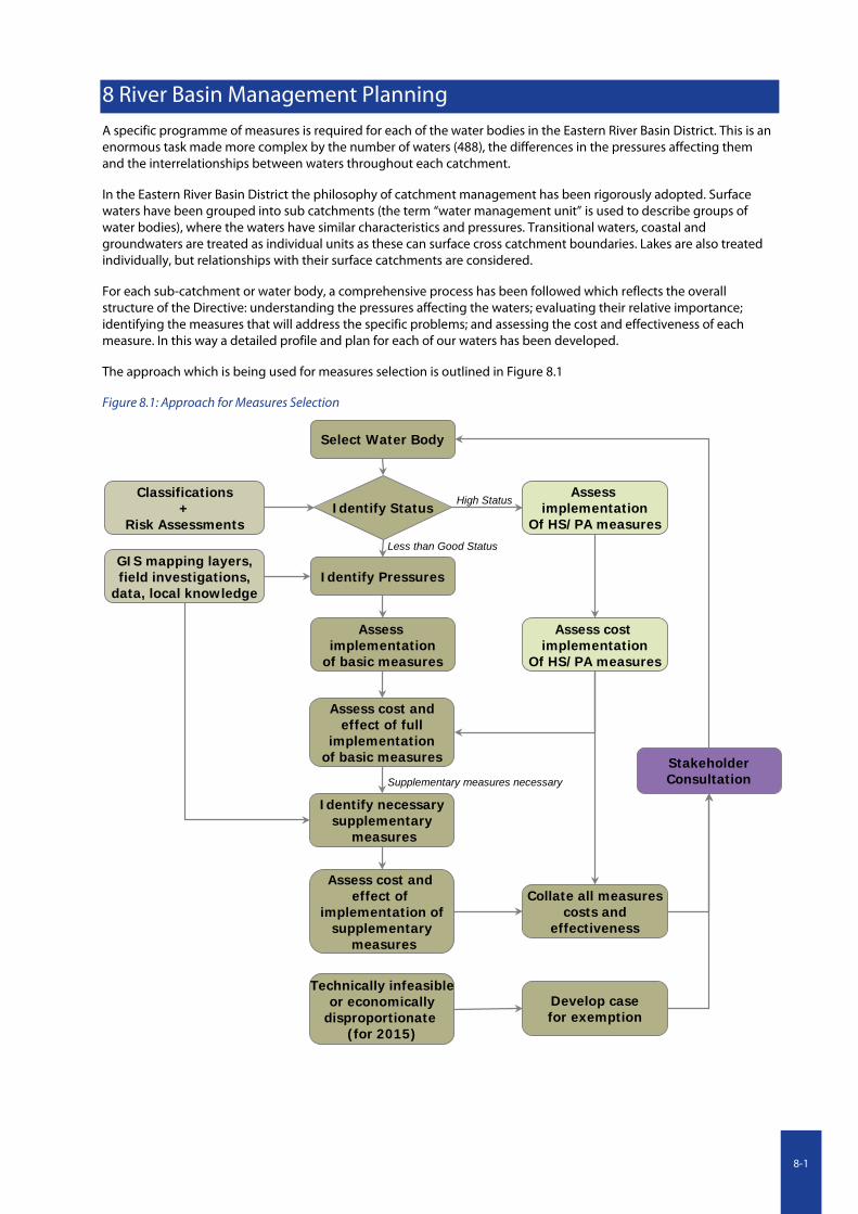
Page 8 of 23
3. Status of Water
River Status:
Good 20%
Moderate 20%
Poor 60%
The existing condition of our waters was determined by the Environmental Protection Agency using water quality, ecology and morphology monitoring data.
The percentage status is determined by the number of reportable segments or sub-basins. For this reason the percentage might not seem representative.
Page 10 of 23
5. Protected Areas
Some areas require greater protection because they contain rare and vulnerable habitats or wildlife. Other protected areas are sensitive because of their beneficial use for humans, such as drinking water sources or shellfish areas.
Drinking Water (1)
i River Tremblestown
Special Areas of Conservation (Habitat) (2)
iRiver Boyne and River Blackwater
Natural Heritage Areas (2)
i Lough Shesk and Girley Bog
Page 17 of 23
9. Target Date
In some cases due to technical infeasibility, disproportionate cost, the natural condition of the water body or new physical modifications it may not be possible to achieve all core objectives by 2015.
The main pressure preventing achievement of Good Status is thought to be diffuse agricultural and point sources pollution. Full implementation of the measures is expected to correct this, however recovery time will mean that the larger rivers will not achieve Good Status before 2015. 2015 40%
2021 80%
2027 100%
The percentage status is determined by the number of reportable segments or sub-basins. For this reason the percentage might not seem representative.
The present status of the waters in the water management unit is shown. These are provided by the EPA and are considered to be “interim” as they are based on only 2 years of data and because many water bodies have no monitoring stations within them.
All of the protected areas in the water management unit are listed and shown in map form.
The subsequent slides describe:
the problems facing the waters in the area; and
the causes of those problems.
A series of slides then describes the basic measures (existing legislation) in place and the specific combination of basic and additional specific actions considered necessary to achieve the objectives of the WFD; this combination of measures is termed “priority actions” in this Plan. These are listed for each local authority which has land in the area of concern (the priority action elements of basic measures for Meath are shown as an example):
The target dates for achieving good status for each water body and the justification for those dates are also shown:
8-8