Appraisal Tracker. Accessing “Appraisal Tracker” Go to Click on “Appraisal Tracker” button.
8. Appraisal and Evaluation Summary Tables - Highways...
68
POPE One Year After Evaluation: M1 Junction 31-32 Widening POPE _ M1 J31-32 OYA _ final.docx 84 8. Appraisal and Evaluation Summary Tables Introduction Appraisal Summary Table (AST) 8.1 The Appraisal Summary Table (AST) is a one page summary of the main economic, safety, environmental and social impacts of a trunk road scheme. Table 8.1 presents the AST for the M1 J31-32 Widening Scheme prepared at the time of the scheme’s appraisal. 8.2 The AST presents a brief description of the scheme, a problem statement detailing the problems that the scheme was planned to address, and makes an assessment of the schemes predicted qualitative and quantitative impacts against the following core NATA (New Approach to Appraisal) objectives: Environment – an estimate of scheme impact upon factors such as noise, local air quality, landscape, biodiversity, heritage and water; Safety – measured reduction in accidents and qualitative assessment of impacts on security; Economy – estimated impact of the scheme upon Journey Times, Vehicle Operating Costs; scheme cost and journey time reliability; Accessibility – a review of scheme impact upon access to the public transport network, community severance and non-motorised user impact; and Integration – a description of how a scheme is integrated with wider local planning policy objectives. Evaluation Summary Table (EST) 8.3 The Evaluation Summary Table (EST) was devised for the POPE process, to record a summary of the reforecast impacts for the NATA objectives, compared to the predictions in the AST. 8.4 Drawing on results presented in this report, Table 8.2 presents the EST for the M1 J31-32 Widening Scheme. 8.5 Where possible, the format of the EST mirrors the appearance and process of the AST to enable direct comparison between the two.
Transcript of 8. Appraisal and Evaluation Summary Tables - Highways...
POPE One Year After Evaluation: M1 Junction 31-32 Widening
POPE _ M1 J31-32 OYA _ final.docx 84
8. Appraisal and Evaluation Summary Tables IntroductionAppraisal Summary Table (AST)
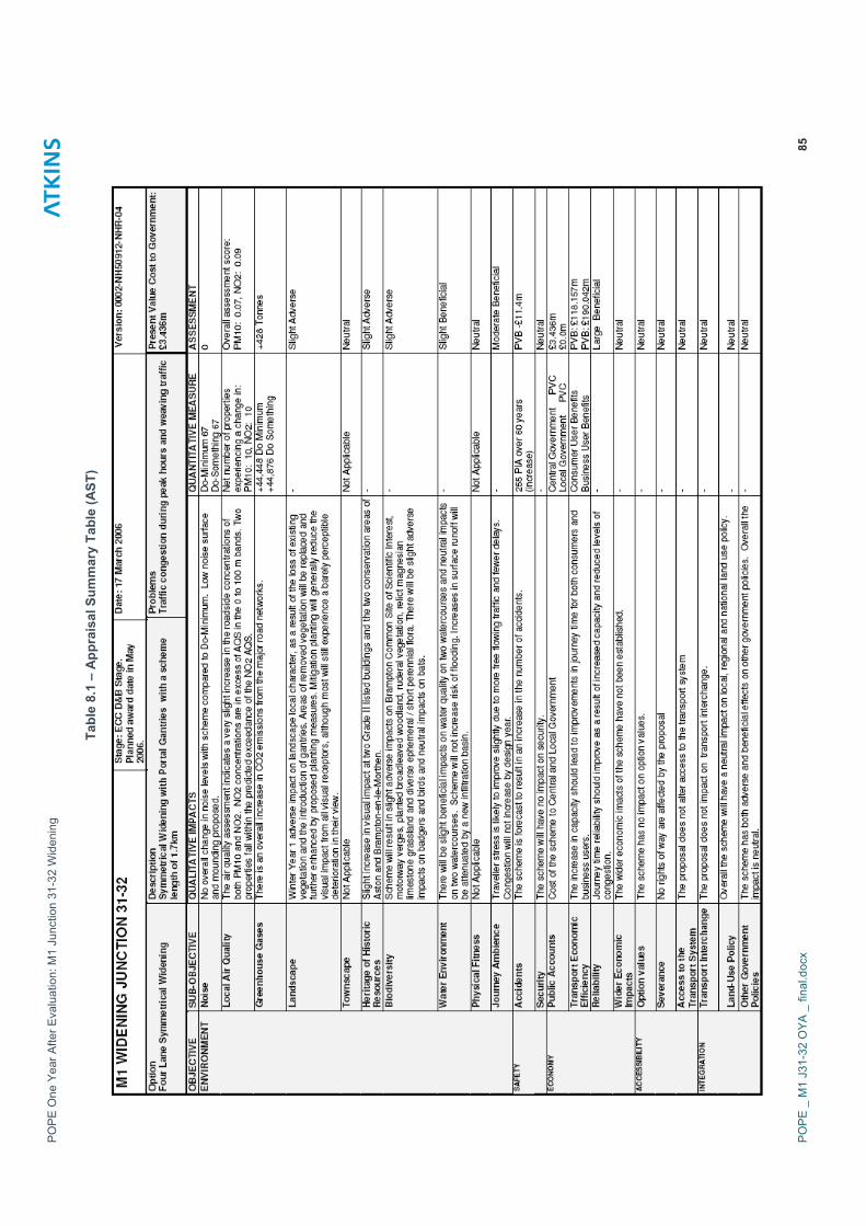
8.1 The Appraisal Summary Table (AST) is a one page summary of the main economic, safety, environmental and social impacts of a trunk road scheme. Table 8.1 presents the AST for the M1 J31-32 Widening Scheme prepared at the time of the scheme’s appraisal.
8.2 The AST presents a brief description of the scheme, a problem statement detailing the problems that the scheme was planned to address, and makes an assessment of the schemes predicted qualitative and quantitative impacts against the following core NATA (New Approach to Appraisal) objectives:
� Environment – an estimate of scheme impact upon factors such as noise, local air quality, landscape, biodiversity, heritage and water;
� Safety – measured reduction in accidents and qualitative assessment of impacts on security;
� Economy – estimated impact of the scheme upon Journey Times, Vehicle Operating Costs; scheme cost and journey time reliability;
� Accessibility – a review of scheme impact upon access to the public transport network, community severance and non-motorised user impact; and
� Integration – a description of how a scheme is integrated with wider local planning policy objectives.
Evaluation Summary Table (EST)
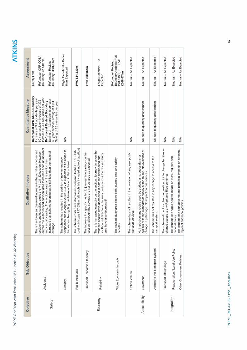
8.3 The Evaluation Summary Table (EST) was devised for the POPE process, to record a summary of the reforecast impacts for the NATA objectives, compared to the predictions in the AST.
8.4 Drawing on results presented in this report, Table 8.2 presents the EST for the M1 J31-32 Widening Scheme.
8.5 Where possible, the format of the EST mirrors the appearance and process of the AST to enable direct comparison between the two.
PO
PE
One
Yea
r Afte
r Eva
luat
ion:
M1
Junc
tion
31-3
2 W
iden
ing
PO
PE
_ M
1 J3
1-32
OYA
_ fi
nal.d
ocx
85
Tabl
e 8.
1 –
App
rais
al S
umm
ary
Tabl
e (A
ST)

PO
PE
One
Yea
r Afte
r Eva
luat
ion:
M1
Junc
tion
31-3
2 W
iden
ing
PO
PE
_ M
1 J3
1-32
OYA
_ fi
nal.d
ocx
86
Tabl
e 8.
2 –
Eval
uatio
n Su
mm
ary
Tabl
e (E
ST)
Obj
ectiv
e Su
b O
bjec
tive
Qua
litat
ive
Impa
cts
Qua
ntita
tive
Mea
sure
A
sses
smen
t
Noi
se
Noi
se m
ound
and
low
noi
se s
urfa
ce h
ave
been
pro
vide
d. B
ased
on
traffi
c flo
ws
whi
ch a
re s
light
ly le
ss th
an b
efor
e th
e im
prov
emen
ts
and
also
less
than
fore
cast
ed, t
he lo
cal n
oise
clim
ate
shou
ld b
e no
w
orse
than
bef
ore
the
sche
me
and
mig
ht b
e be
tter t
han
expe
cted
..
As
Exp
ecte
d - 0
Pos
sibl
y be
tter t
han
expe
cted
Loca
l Air
Qua
lity
Bas
ed o
n tra
ffic
flow
s w
hich
are
less
than
fore
cast
the
loca
l air
qual
ity is
like
ly to
be
sim
ilar t
o be
fore
the
impr
ovem
ents
and
is
poss
ibly
bet
ter t
han
expe
cted
.
Pos
sibl
y B
ette
r tha
n E
xpec
ted
Gre
enho
use
Gas
es
The
sche
me
has
resu
lted
in a
n in
crea
se in
CO
2 em
issi
ons,
al
thou
gh n
ot a
s m
uch
as o
rigin
ally
fore
cast
. In
the
revi
sed
stud
y ar
ea, t
he D
M C
arbo
n em
issi
ons
are
+92,
551
and
for t
he D
S
+93,
453.
Thi
s eq
uate
s to
an
incr
ease
in c
arbo
n em
issi
ons
of 9
0 to
nnes
.
Do
Min
imum
+18
,900
Do
Som
ethi
ng 1
8,99
0 +9
0 To
nnes
Land
scap
e
New
pla
ntin
g/se
edin
g pr
ovid
ed a
nd e
stab
lishi
ng s
atis
fact
orily
; on
goin
g es
tabl
ishm
ent s
houl
d be
eva
luat
ed a
t the
five
yea
r afte
r st
age.
The
ligh
ting
prop
osed
as
part
of th
e in
itial
Sch
eme
was
not
ta
ken
forw
ard
to c
onst
ruct
ion
and
this
was
take
n in
to a
ccou
nt in
the
2006
AS
T us
ed fo
r thi
s re
port.
Ove
rall
the
eval
uatio
n is
con
side
red
as
exp
ecte
d in
the
AS
T bu
t bet
ter t
han
expe
cted
in th
e E
S
As
Exp
ecte
d –
Slig
ht
Adv
erse
Tow
nsca
pe
N/A
N
/A
N/A
Her
itage
of H
isto
ric R
esou
rces
It is
con
side
red
that
the
prov
isio
n of
the
envi
ronm
enta
l ear
thbu
nd
and
new
land
scap
e pl
antin
g ad
jace
nt to
Ves
sey
Clo
se F
arm
has
he
lped
scr
een
the
setti
ng o
f the
Lis
ted
Bui
ldin
gs a
nd id
entif
ied
SM
R R
idge
and
Fur
row
and
con
serv
atio
n ar
eas
from
the
mot
orw
ay
wid
enin
g an
d im
pact
s as
exp
ecte
d.
As
Exp
ecte
d –
Slig
ht
Adv
erse
Bio
dive
rsity
From
the
info
rmat
ion
rece
ived
, in
the
Con
stru
ctio
n E
nviro
nmen
tal
Man
agem
ent P
lan
and
Gre
at C
rest
ed N
ewt M
onito
ring
reco
rds
year
1, t
oget
her w
ith th
e es
tabl
ishm
ent o
f veg
etat
ion
view
ed d
urin
g th
e si
te v
isit,
the
impa
cts
of th
e S
chem
e on
Bio
dive
rsity
are
like
ly to
be
As
Exp
ecte
d.
As
Exp
ecte
d –
Slig
ht
Adv
erse
Wat
er E
nviro
nmen
t
Pol
lutio
n co
ntro
l mea
sure
s ha
ve b
een
inco
rpor
ated
into
the
sche
me
and
it w
as a
gree
d w
ith E
A th
at th
e pr
opos
ed In
filtra
tion
area
at J
31 w
as n
ot re
quire
d. B
ased
on
the
info
rmat
ion
avai
labl
e it
is li
kely
that
the
impa
cts
are
as e
xpec
ted
how
ever
wat
er s
houl
d be
co
nsid
ered
with
in th
e 5Y
A re
port
whe
n m
ore
info
rmat
ion
may
be
avai
labl
e.
As
Exp
ecte
d –
Slig
ht
Ben
efic
ial (
Bas
ed o
n th
e In
form
atio
n A
vaila
ble)
Phy
sica
l Fitn
ess
The
site
vis
it co
nfirm
ed th
at p
aths
hav
e re
mai
ned
open
ther
e w
as
no re
stric
tion
to a
cces
s al
ong
them
or a
dditi
onal
sev
eran
ce.
Dro
pped
ker
bs h
ave
been
pro
vide
d as
reco
mm
ende
d w
ithin
the
NM
U s
urve
y of
200
2.
N/A
A
s E
xpec
ted
- Neu
tral
Env
ironm
ent
Jour
ney
Am
bien
ce
The
prop
osed
off
site
pla
ntin
g ha
s no
t bee
n un
derta
ken
allo
win
g m
ore
long
dis
tanc
e op
en v
iew
s fo
r mot
orw
ay u
sers
to th
e su
rrou
ndin
g co
untry
side
. The
impa
ct o
n tra
velle
r stre
ss is
mod
erat
e be
nefic
ial d
ue to
impr
oved
jour
ney
times
and
driv
er in
form
atio
n.
As
Exp
ecte
d –
Mod
erat
e B
enef
icia
l
PO
PE
One
Yea
r Afte
r Eva
luat
ion:
M1
Junc
tion
31-3
2 W
iden
ing
PO
PE
_ M
1 J3
1-32
OYA
_ fi
nal.d
ocx
87
Obj
ectiv
e Su
b O
bjec
tive
Qua
litat
ive
Impa
cts
Qua
ntita
tive
Mea
sure
A
sses
smen
t
Acc
iden
ts
Ther
e ha
s be
en a
n ob
serv
ed in
crea
se in
the
num
ber o
f obs
erve
d ac
cide
nts
and
casu
altie
s al
ong
the
M1
J31-
32 s
ectio
n. H
owev
er,
acro
ss th
e w
ider
revi
sed
acci
dent
are
a th
ere
has
been
an
acci
dent
an
d ca
sual
ty s
avin
g. T
he a
ccid
ent r
ate
on th
e se
ctio
n ha
s in
crea
sed
post
sch
eme
open
ing
but i
s st
ill le
ss th
an th
e na
tiona
l av
erag
e.
Ref
orec
ast O
PR C
OB
A B
ound
ary
In
crea
se o
f 3.7
acc
iden
ts p
er y
ear
60 y
ear a
ccid
ent i
ncre
ase
of 3
02
Incr
ease
of 4
.7 c
asua
lties
per
yea
r R
efor
ecas
t Rev
ised
Bou
ndar
y S
avin
g of
14.
3 ac
cide
nts
per y
ear
60 y
ear a
ccid
ent s
avin
g of
118
1
Sav
ing
of 2
3 ca
sual
ties
per y
ear
Saf
ety
PV
B
Ref
orec
ast O
PR C
OBA
B
ound
ary
-£17
.987
m
Ref
orec
ast R
evis
ed
Bou
ndar
y +£
70,3
13m
S
afet
y
Sec
urity
Th
e sc
hem
e ha
s re
sulte
d in
the
addi
tion
of n
ew e
mer
genc
y te
leph
ones
and
in A
ugus
t 200
9 C
CTV
is e
xpec
ted
to b
e ad
ded
to
the
sect
ion.
No
light
ing
has
been
incl
uded
in th
e sc
hem
e.
N/A
S
light
Ben
efic
ial –
Bet
ter
than
Exp
ecte
d
Pub
lic A
ccou
nts
The
sche
me
cost
s ha
ve d
ecre
ased
com
pare
d to
the
OP
R C
OB
A co
st w
hich
was
£17
.059
m (a
lthou
gh th
is in
clud
ed in
dire
ct ta
xatio
n)
PV
C £
11.3
39m
Tran
spor
t Eco
nom
ic E
ffici
ency
Th
e in
crea
se in
cap
acity
has
led
to jo
urne
y tim
e sa
ving
s on
the
sect
ion,
alth
ough
the
savi
ngs
are
not a
s la
rge
as e
xpec
ted.
PV
B £
60.0
61m
Rel
iabi
lity
Ther
e is
incr
ease
d ca
paci
ty o
n th
e se
ctio
n. J
ourn
ey ti
mes
on
the
wid
ened
sec
tion
have
dec
reas
ed in
bot
h th
e no
rthbo
und
and
sout
hbou
nd d
irect
ions
. Jou
rney
tim
es a
cros
s th
e re
vise
d st
udy
area
hav
e al
so d
ecre
ased
/
Larg
e Be
nefic
ial -
As
Exp
ecte
d E
cono
my
Wid
er E
cono
mic
Impa
cts
The
revi
sed
stud
y ar
ea s
how
s bo
th jo
urne
y tim
e an
d sa
fety
be
nefit
s.
Ref
orec
ast R
evis
ed
Bou
ndar
y A
ccid
ent P
VB
£7
0.31
3m, T
EE
PVB
£3
68.6
74m
Opt
ion
Val
ues
The
sche
me
has
not r
esul
ted
in th
e pr
ovis
ion
of a
ny n
ew p
ublic
tra
nspo
rt se
rvic
es.
N/A
N
eutra
l – A
s E
xpec
ted
Sev
eran
ce
No
impa
ct o
n an
y ro
utes
use
d by
ped
estri
ans,
equ
estri
ans
or
cycl
ists
or t
o th
e st
anda
rd o
r qua
lity
of th
e ro
utes
. No
evid
ence
of
chan
ge in
pat
rona
ge. N
o im
pact
on
bus
serv
ices
. N
o da
ta to
qua
ntify
ass
essm
ent
Neu
tral –
As
Exp
ecte
d A
cces
sibi
lity
Acc
ess
to th
e Tr
ansp
ort S
yste
m
The
sche
me
has
not r
esul
ted
in a
ny c
hang
e to
acc
ess
to th
e tra
nspo
rt sy
stem
. N
o da
ta to
qua
ntify
ass
essm
ent
Neu
tral –
As
Exp
ecte
d
Tran
spor
t Int
erch
ange
Th
e sc
hem
e di
d no
t inv
olve
the
crea
tion
of in
terc
hang
e fa
cilit
ies
or
chan
ge a
cces
s to
any
Par
k an
d R
ide
sche
mes
. N
/A
Neu
tral –
As
Exp
ecte
d
Reg
ener
atio
n / L
and
Use
Pol
icy
The
sche
me
has
had
a ne
utra
l im
pact
on
loca
l, re
gion
al a
nd
natio
nal p
olic
y.
N/A
N
eutra
l – A
s E
xpec
ted
Inte
grat
ion
Oth
er G
over
nmen
t Pol
icie
s Th
e sc
hem
e ha
s bo
th a
dver
se a
nd b
enef
icia
l im
pact
s on
nat
iona
l, re
gion
al a
nd lo
cal p
olic
ies.
N
/A
Neu
tral –
As
Exp
ecte
d
POPE One Year After Evaluation: M1 Junction 31-32 Widening
POPE _ M1 J31-32 OYA _ final.docx 88
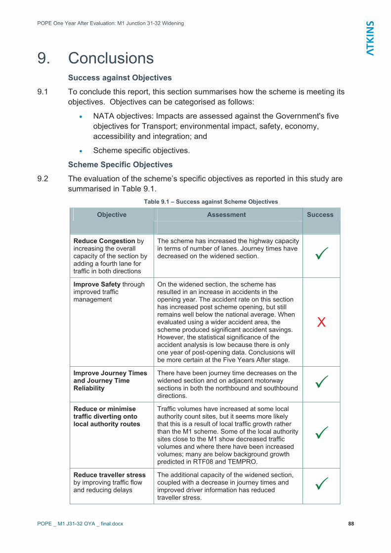
9. Conclusions Success against Objectives
9.1 To conclude this report, this section summarises how the scheme is meeting its objectives. Objectives can be categorised as follows:
� NATA objectives: Impacts are assessed against the Government's five objectives for Transport; environmental impact, safety, economy, accessibility and integration; and
� Scheme specific objectives.
Scheme Specific Objectives
9.2 The evaluation of the scheme’s specific objectives as reported in this study are summarised in Table 9.1.
Table 9.1 – Success against Scheme Objectives
Assessment Objective Success
Reduce Congestion by increasing the overall capacity of the section by adding a fourth lane for traffic in both directions
The scheme has increased the highway capacity in terms of number of lanes. Journey times have decreased on the widened section. ��
Improve Safety through improved traffic management
On the widened section, the scheme has resulted in an increase in accidents in the opening year. The accident rate on this section has increased post scheme opening, but still remains well below the national average. When evaluated using a wider accident area, the scheme produced significant accident savings. However, the statistical significance of the accident analysis is low because there is only one year of post-opening data. Conclusions will be more certain at the Five Years After stage.
X
Improve Journey Times and Journey Time Reliability
There have been journey time decreases on the widened section and on adjacent motorway sections in both the northbound and southbound directions.
��Reduce or minimise traffic diverting onto local authority routes
Traffic volumes have increased at some local authority count sites, but it seems more likely that this is a result of local traffic growth rather than the M1 scheme. Some of the local authority sites close to the M1 show decreased traffic volumes and where there have been increased volumes; many are below background growth predicted in RTF08 and TEMPRO.
��
Reduce traveller stressby improving traffic flow and reducing delays
The additional capacity of the widened section, coupled with a decrease in journey times and improved driver information has reduced traveller stress.
��

POPE One Year After Evaluation: M1 Junction 31-32 Widening
POPE _ M1 J31-32 OYA _ final.docx 89
9.3 In summary, the results in Table 9.1 show that based on the data available at the one year after stage, the M1 J31-32 Widening scheme is achieving all of its objectives, with the exception of accidents on the J31-32 link itself. However, this increase in accidents is far outweighed by the accident reduction on adjacent motorway links.
Did the Scheme offer Good Value for Money?
9.4 The scheme economics have been complicated by the general reduction in traffic flows on the motorway network in the area over recent years. The impact of this is to reduce the amount of vehicle hours on the network, which is normally an indicator of success on a major road scheme, but in this case the benefits cannot wholly be attributed to the scheme. The significant journey time benefits on the motorway also contribute towards the scheme benefits, but it is not clear whether journey times have improved because of the scheme or because traffic flows have decreased. It is likely to be a combination of these two factors but the relative importance of each is unknown.
9.5 The outturn cost of the scheme was only 66% of the forecast scheme cost which has contributed to the good Benefit Cost Ratio of the scheme.
9.6 The scheme has delivered healthy benefits and Benefit Cost Ratio in both the local study area and the wider study area. A cautious approach, of analysing just the single, widened motorway link, results in monetary benefits of nearly £40mand a BCR of 3.5 even when the effect of decreasing traffic flows is removed.This is considered good value for money.
9.7 If the wider network is considered, the apparent benefits increase significantly to £344m and a BCR of 30. However, it is felt that this approach includes too many non-scheme specific effects to be considered robust and that the local area economics should be used in reporting.
Five Years After study
9.8 The Five Years After study due to be undertaken in 2013 will follow a similar structure to this One Year After study setting out a comparison of the forecast and outturn impacts of the scheme against each of the NATA objectives (and sub-objectives) five years after opening. This will examine whether the successes reported in this report are continuing.
9.9 Particular issues for the five years after stage will be:
� Results from the analysis of accident analysis at the five years after stage are likely to offer greater robustness than those recorded at the one year after stage;
� A more detailed assessment of the wider impacts of the scheme should be undertaken, potentially comparing the impact on this section with other sections of the M1 and M62; and
� The environmental evaluation will focus more closely on the effectiveness of mitigation measures would should be more evident at the five years after stage.

POPE One Year After Evaluation: M1 Junction 31-32 Widening
POPE _ M1 J31-32 OYA _ final.docx 90
Appendix A Traffic Volume Tables with Growth

POPE One Year After Evaluation: M1 Junction 31-32 Widening
POPE _ M1 J31-32 OYA _ final.docx 91
A.1 HA Traffic Volumes and Growth Table A.1 - AADT Flow for M1 J30-31
Northbound (Site 1) Southbound (Site 2) Year
AADT Index AADT IndexRTF 08
2003 56,558 1.000 56,952 1.000 1.000
2004 55,179 0.976 55,380 0.972 1.005
2005 54,874 0.970 54,769 0.962 1.011
2006 54,784 0.969 55,146 0.968 1.016
2007 52,523 0.929 55,245 0.970 1.019
2008/09 53,417 0.944 53,879 0.946 1.023
Change & Average Annual Rate of Growth - 3,141 -1.1% - 3,073 -1.1% 0.5%
Table A.2 - AADT Flow for M1 J31-32
Northbound (Site 3) Southbound (Site 4) Year
AADT Index AADT IndexRTF 08
2003 66,426 1.000 67,438 1.000 1.000
2004 66,015 0.994 67,075 0.995 1.005
2005 66,301 0.998 67,128 0.995 1.011
2006 66,056 0.994 66,737 0.990 1.016
2007 No Data No Data No Data No Data 1.019
2008/09 65,462 0.985 65,470 0.971 1.023
Change & Average Annual Rate of Growth - 964 -0.3% - 1,968 -0.6% 0.5%
Table A.3 - AADT Flow for M1 J32-33
Northbound (Site 5) Southbound (Site 6) Year
AADT Index AADT IndexRTF 08
2003 60,594 1.000 62,302 1.000 1.000
2004 60,085 0.992 61,407 0.986 1.005
2005 60,564 1.000 61,817 0.992 1.011
2006 57,629 0.951 59,897 0.961 1.016
2007 56,322 0.929 58,582 0.940 1.019
2008/09 57,533 0.949 58,271 0.935 1.023
Change & Average Annual Rate of Growth - 3,061 -1.0% - 4,031 -1.3% 0.5%

POPE One Year After Evaluation: M1 Junction 31-32 Widening
POPE _ M1 J31-32 OYA _ final.docx 92
Table A.4 - AADT Flow for M1 J33-34
Northbound (Site 7) Southbound (Site 8) Year
AADT Index AADT IndexRTF 08
2003 52,762 1.000 53,974 1.000 1.000
2004 51,212 0.971 52,364 0.970 1.005
2005 53,251 1.009 53,906 0.999 1.011
2006 51,927 0.984 52,698 0.976 1.016
2007 50,011 0.948 51,668 0.957 1.019
2008/09 50,208 0.952 50,777 0.941 1.023
Change & Average Annual Rate of Growth - 2,554 -1.0% - 3,197 -1.2% 0.5%
Table A.5 - AADT Flow for M18 J1- M1 J32
Northbound (Site 9) Southbound (Site 10) Year
AADT Index AADT IndexRTF 08
2003 41,453 1.000 39,840 1.000 1.000
2004 41,325 0.997 39,988 1.004 1.004
2005 41,659 1.005 40,379 1.014 1.008
2006 41,942 1.012 41,023 1.030 1.013
2007 No Data No Data No Data No Data 1.017
2008/09 40,584 0.979 40,132 1.007 1.021
Change & Average Annual Rate of Growth - 869 -0.4% 292 0.1% 0.5%

POPE One Year After Evaluation: M1 Junction 31-32 Widening
POPE _ M1 J31-32 OYA _ final.docx 93
A.2 SCC Traffic Volumes and Growth Table A.6 - 2006 & 2008 AADT flow for A6102 Bochum Parkway
Year Southbound Index Northbound Index RTF 08 2006 12,879 1.000 15,685 1.000 1.000 2008 13,468 0.046 16,033 0.022 1.011
Annual Growth Rate 589 2.3% 348 1.1% 0.6%
Table A.7 - 2006 & 2008 AADT flow for A57 Mosborough Parkway
Year Towards Sheffield Index Away from
Sheffield Index RTF 08
2006 14,270 1.000 13,787 1.000 1.000 2008 14,573 0.021 13,931 0.010 1.011
Annual Growth Rate 303 1.1% 144 0.5% 0.6%
Table A.8 - 2006 & 2008 AADT flow for A57 Sheffield Parkway
Year Towards Sheffield Index Away from
Sheffield Index RTF 08
2006 28,316 1.000 26,591 1.000 1.000 2008 29,868 0.055 27,432 0.032 1.011
Annual Growth Rate 1,552 2.7% 841 1.6% 0.6%
Table A.9 - 2006 & 2008 AADT flow for A6102 Prince of Wales Road
Year Towards Sheffield Index Away from
Sheffield Index RTF 08
2006 15,105 1.000 14,017 1.000 1.000 2008 14,900 -0.014 15,080 0.076 1.011
Annual Growth Rate - 205 -0.7% 1063 3.7% 0.6%
Table A.10 - 2006 & 2008 AADT flow for A63 Shepcote Lane
Year Southbound Index Northbound Index RTF 08 2006 7,204 1.000 7,687 1.000 1.000 2008 7,296 0.013 7,764 0.010 1.011
Annual Growth Rate 92 0.6% 77 0.5% 0.6%
Table A.11 - 2006 & 2008 24 Hour AADT flow for A6178 Attercliffe Common
Year Towards Sheffield Index Away from
Sheffield Index RTF 08
2006 18,696 1.000 15,456 1.000 1.000 2008 18,501 -0.010 15,524 0.004 1.011
Annual Growth Rate - 195 -0.5% 68 0.2% 0.6%
Table A.12 - 2006 & 2008 AADT flow for M1 J34 SB Exit Slip
Year Flow Index RTF 08 2006 13,139 1.000 1.000 2008 12,883 -0.019 1.011
Annual Growth Rate - 256 -1.0% 0.6%
Table A.13 - 2006 & 2008 AADT flow for M1 J34 SB Exit Slip
Year Flow Index RTF 08 2006 13,529 1.000 1.000 2008 13,284 -0.018 1.011
Annual Growth Rate - 195 -0.9% 0.6%

POPE One Year After Evaluation: M1 Junction 31-32 Widening
POPE _ M1 J31-32 OYA _ final.docx 94
Appendix B – A6102 Timing Points
POPE One Year After Evaluation: M1 Junction 31-32 Widening
POPE _ M1 J31-32 OYA _ final.docx 95
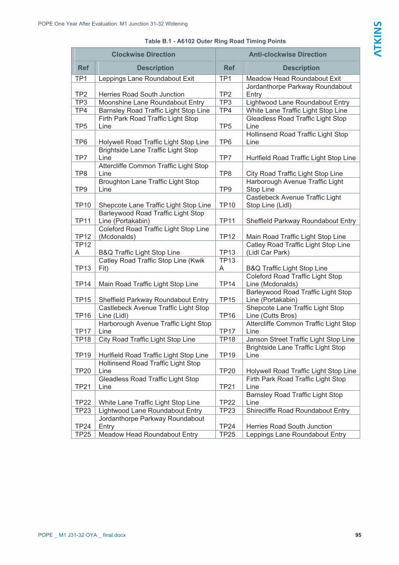
Table B.1 - A6102 Outer Ring Road Timing Points
Clockwise Direction Anti-clockwise Direction
Ref Description Ref Description TP1 Leppings Lane Roundabout Exit TP1 Meadow Head Roundabout Exit
TP2 Herries Road South Junction TP2 Jordanthorpe Parkway Roundabout Entry
TP3 Moonshine Lane Roundabout Entry TP3 Lightwood Lane Roundabout Entry TP4 Barnsley Road Traffic Light Stop Line TP4 White Lane Traffic Light Stop Line
TP5Firth Park Road Traffic Light Stop Line TP5
Gleadless Road Traffic Light Stop Line
TP6 Holywell Road Traffic Light Stop Line TP6 Hollinsend Road Traffic Light Stop Line
TP7Brightside Lane Traffic Light Stop Line TP7 Hurlfield Road Traffic Light Stop Line
TP8Attercliffe Common Traffic Light Stop Line TP8 City Road Traffic Light Stop Line
TP9Broughton Lane Traffic Light Stop Line TP9
Harborough Avenue Traffic Light Stop Line
TP10 Shepcote Lane Traffic Light Stop Line TP10 Castlebeck Avenue Traffic Light Stop Line (Lidl)
TP11Barleywood Road Traffic Light Stop Line (Portakabin) TP11 Sheffield Parkway Roundabout Entry
TP12Coleford Road Traffic Light Stop Line (Mcdonalds) TP12 Main Road Traffic Light Stop Line
TP12A B&Q Traffic Light Stop Line TP13
Catley Road Traffic Light Stop Line (Lidl Car Park)
TP13Catley Road Traffic Stop Line (Kwik Fit)
TP13A B&Q Traffic Light Stop Line
TP14 Main Road Traffic Light Stop Line TP14 Coleford Road Traffic Light Stop Line (Mcdonalds)
TP15 Sheffield Parkway Roundabout Entry TP15 Barleywood Road Traffic Light Stop Line (Portakabin)
TP16Castlebeck Avenue Traffic Light Stop Line (Lidl) TP16
Shepcote Lane Traffic Light Stop Line (Cutts Bros)
TP17Harborough Avenue Traffic Light Stop Line TP17
Attercliffe Common Traffic Light Stop Line
TP18 City Road Traffic Light Stop Line TP18 Janson Street Traffic Light Stop Line
TP19 Hurlfield Road Traffic Light Stop Line TP19 Brightside Lane Traffic Light Stop Line
TP20Hollinsend Road Traffic Light Stop Line TP20 Holywell Road Traffic Light Stop Line
TP21Gleadless Road Traffic Light Stop Line TP21
Firth Park Road Traffic Light Stop Line
TP22 White Lane Traffic Light Stop Line TP22 Barnsley Road Traffic Light Stop Line
TP23 Lightwood Lane Roundabout Entry TP23 Shirecliffe Road Roundabout Entry
TP24Jordanthorpe Parkway Roundabout Entry TP24 Herries Road South Junction
TP25 Meadow Head Roundabout Entry TP25 Leppings Lane Roundabout Entry

POPE One Year After Evaluation: M1 Junction 31-32 Widening
POPE _ M1 J31-32 OYA _ final.docx 96
Appendix C – Calculation of Route Stress

PO
PE
One
Yea
r Afte
r Eva
luat
ion:
M1
Junc
tion
31-3
2 W
iden
ing
PO
PE
_ M
1 J3
1-32
OYA
_ fi
nal.d
ocx
97
C.1
C
alcu
latio
n of
Rou
te S
tress
Cal
cula
tion
of R
oute
Str
ess
(Rel
iabi
lity)
Bas
ed o
n ap
proa
ch in
GO
MM
MS
Vol 2
par
a 6.
3.12
and
App
endi
x I.
Con
gest
ion
Ref
eren
ce F
low
bas
ed o
n D
MR
B 5
.1.3
Ann
ex D
for M
otor
way
Link
AB
PkH
CAP
ACIT
YN
LW
fPk
FPk
DAA
DT
AAW
TC
RF
Cal
cula
ted
Stre
ssM
1 J3
1-32
Befo
re
2300
25.0
23.4
1715
31
7.3
52.5
1327
9314
3079
1243
8810
6.8%
M1
J31-
32Af
ter
2300
25.0
18.3
1842
.54
17.
552
.513
0932
1431
1617
1732
76.2
%
A, B
- se
t par
amet
ers
in th
e ca
lcul
atio
n of
Rou
tetre
ss b
y ro
ad s
tand
ard
PkH
- P
erce
ntag
e H
GV
in P
eak
hour
, in
peak
dire
ctio
nC
apac
ity =
[A-(
B*Pk
H)]
NL
is th
e N
umbe
r of L
anes
per
dire
ctio
n;W
f is
a W
idth
Fac
tor
PkF
is th
e pr
opor
tion
(per
cent
age)
of t
he to
tal d
aily
flow
(2-w
ay) t
hat o
ccur
s in
the
peak
hou
r;P
kD is
the
dire
ctio
nal s
plit
(per
cent
age)
of t
he p
eak
hour
flow
;A
AD
T is
the
Ann
ual A
vera
ge D
aily
Tra
ffic
flow
on
the
link;
AA
WT
is th
e A
nnua
l Ave
rage
Wee
kday
Tot
al (M
on -
Frid
ay a
vera
ge)
CR
F - C
onge
stio
n R
efer
ence
Flo
w: A
n A
AD
T es
timat
e at
whi
ch a
road
is li
kely
to b
ecom
e co
nges
ted
in th
e pe
ak p
erio
ds o
n an
ave
rage
day
CR
F=C
apac
ity*N
L*W
f*10
0/P
kF*1
00/P
kD*A
AD
T/A
AWT
Stre
ss =
AA
DT/
CR
F

POPE One Year After Evaluation: M1 Junction 31-32 Widening
POPE _ M1 J31-32 OYA _ final.docx 98
Appendix D – Calculation of Accident Rates

POPE One Year After Evaluation: M1 Junction 31-32 Widening
POPE _ M1 J31-32 OYA _ final.docx 99
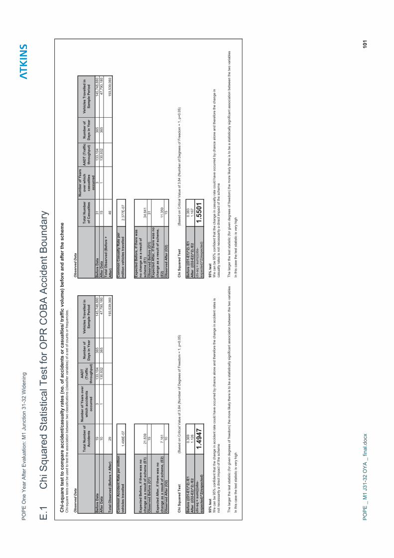
D.1 Accident Rate for OPR COBA Accident Boundary
Calculation of Accident Rates: M1 J31-32 Widening
Period km AADT No. days total mvkm accidents2004 4 133090 365 194311400 194 52005 4 133429 365 194806340 195 82006 4 132793 365 193877780 194 6
Total 3 Years Before 583 19Accident Rate 3 years before 0.033
2008 4 130932 365 191160720 191 10Total 1 Years After 191 10
Accident Rate 1 Years After 0.052
Calculation of National Accident Rates based on COBA manual default accident rates and Accident Rate Reduction Factor (ß) 2000 base
Road TypeBase Accident Rate
(ß)No of Years to growth
NA Accident
RateBefore D3 Motorway 0.089 1.001 5 0.089After D4 Motorway 0.089 1.001 8 0.090
D.2 Accident Rate for Revised Accident Boundary
Calculation of Accident Rates: M1 J31-32 Widening
Period km AADT No. days total mvkm accidents2004 52 109275 365 2074047574 2074 712005 52 109858 365 2085111366 2085 792006 52 108995 365 2068723326 2069 85
Total 3 Years Before 6228 235Accident Rate 3 years before 0.038
2008 52 106533 365 2021992427 2022 64Total 1 Years After 2022 64
Accident Rate 1 Years After 0.032
Calculation of National Accident Rates based on COBA manual default accident rates and Accident Rate Reduction Factor (ß) 2000 base
Road TypeBase Accident Rate
(ß)No of Years to growth
NA Accident
Rate Before D3 Motorway 0.089 1.001 5 0.089After D4 Motorway 0.089 1.001 8 0.090

POPE One Year After Evaluation: M1 Junction 31-32 Widening
POPE _ M1 J31-32 OYA _ final.docx 100
Appendix E – Chi Squared Statistical Tests
PO
PE
One
Yea
r Afte
r Eva
luat
ion:
M1
Junc
tion
31-3
2 W
iden
ing
PO
PE
_ M
1 J3
1-32
OYA
_ fi
nal.d
ocx
101
E.1
C
hi S
quar
ed S
tatis
tical
Tes
t for
OP
R C
OB
A A
ccid
ent B
ound
ary
Chi
-squ
are
test
to c
ompa
re a
ccid
ent/c
asua
lty ra
tes
(no.
of a
ccid
ents
or c
asua
lties
/ tra
ffic
volu
me)
bef
ore
and
afte
r the
sch
eme
Chi
-squ
are
test
s ca
n be
use
d to
test
the
asso
ciat
ion
betw
een
two
clas
sific
atio
ns (c
lass
ifier
var
iabl
es) o
f a s
et o
f cou
nts
or fr
eque
ncie
s.
Obs
erve
d D
ata
Obs
erve
d D
ata
Tota
l Num
ber o
f Ac
cide
nts
Num
ber o
f Yea
rs o
ver
whi
ch a
ccid
ents
oc
curr
ed
AAD
T (T
raffi
c th
roug
hput
)
Num
ber o
f D
ays
in Y
ear
Vehi
cles
Tra
velle
d in
Sa
mpl
e Pe
riod
Tota
l Num
ber
of C
asua
lties
Num
ber o
f Yea
rs
over
whi
ch
casu
altie
s oc
curr
ed
AAD
T (T
raffi
c th
roug
hput
)N
umbe
r of
Day
s in
Yea
rVe
hicl
es T
rave
lled
in
Sam
ple
Perio
d
Bef
ore
Dat
a19
313
3,10
436
514
5,74
8,88
0
B
efor
e D
ata
313
133,
104
365
145,
748,
880
A
fter D
ata
101
130,
932
365
47,7
90,1
80
A
fter D
ata
151
130,
932
365
47,7
90,1
80
Tota
l Obs
erve
d (B
efor
e +
Afte
r)29
193,
539,
060
Tota
l Obs
erve
d (B
efor
e +
Afte
r)46
193,
539,
060
Com
mon
Acc
iden
t Rat
e pe
r mill
ion
vehi
cles
trav
elle
d1.
498E
-07
Com
mon
Cas
ualty
Rat
e pe
r m
illio
n ve
hicl
es tr
avel
led
2.37
7E-0
7
Expe
cted
Bef
ore,
if th
ere
was
no
chan
ge a
s a
resu
lt of
sch
eme
(E1)
21.8
39
Expe
cted
Bef
ore,
if th
ere
was
no
cha
nge
as a
resu
lt of
sc
hem
e (E
1)34
.641
Obs
erve
d B
efor
e (O
1)19
Obs
erve
d B
efor
e (O
1)31
Expe
cted
Afte
r, if
ther
e w
as n
o ch
ange
as
a re
sult
of s
chem
e, (E
2)7.
161
Expe
cted
Afte
r, if
ther
e w
as n
o ch
ange
as
a re
sult
of s
chem
e,
(E2)
11.3
59O
bser
ved
Afte
r (O
2)10
Obs
erve
d Af
ter (
O2)
15
Chi
Squ
ared
Tes
t(B
ased
on
Crit
ical
Val
ue o
f 3.8
4 (N
umbe
r of D
egre
es o
f Fre
edom
= 1
, p=0
.05)
Chi
Squ
ared
Tes
t(B
ased
on
Crit
ical
Val
ue o
f 3.8
4 (N
umbe
r of D
egre
es o
f Fre
edom
= 1
, p=0
.05)
Bef
ore
((O1-
E1)^
2) /E
10.
369
Bef
ore
((O1-
E1)^
2) /E
10.
383
Afte
r ((O
2-E2
)^2)
/E2
1.12
6A
fter
((O2-
E2)^
2) /E
21.
167
chi-s
q =
sum
(((ob
s-ex
pect
ed)^
2)/e
xpec
ted)
1.49
47ch
i-sq
= su
m((
(obs
-ex
pect
ed)^
2)/e
xpec
ted)
1.55
0195
% te
st95
% te
st
In th
is c
ase
the
test
sta
tistic
is v
ery
high
In th
is c
ase
the
test
sta
tistic
is v
ery
high
We
can
be 9
5% c
onfid
ent t
hat t
he c
hang
e in
acc
iden
t rat
e co
uld
have
occ
urre
d by
cha
nce
alon
e an
d th
eref
ore
the
chan
ge in
acc
iden
t rat
es is
no
t nec
essa
rily
a di
rect
impa
ct o
f the
sch
eme
We
can
be 9
5% c
onfid
ent t
hat t
he c
hang
e in
cas
ualty
rate
cou
ld h
ave
occu
rred
by c
hanc
e al
one
and
ther
efor
e th
e ch
ange
in
casu
alty
rate
s is
not
nec
essa
rily
a di
rect
impa
ct o
f the
sch
eme
The
larg
er th
e te
st s
tatis
tic (f
or g
iven
deg
rees
of f
reed
om) t
he m
ore
likel
y th
ere
is to
be
a st
atis
tical
ly s
igni
fican
t ass
ocia
tion
betw
een
the
two
varia
bles
The
larg
er th
e te
st s
tatis
tic (f
or g
iven
deg
rees
of f
reed
om) t
he m
ore
likel
y th
ere
is to
be
a st
atis
tical
ly s
igni
fican
t ass
ocia
tion
betw
een
the
two
varia
bles

PO
PE
One
Yea
r Afte
r Eva
luat
ion:
M1
Junc
tion
31-3
2 W
iden
ing
PO
PE
_ M
1 J3
1-32
OYA
_ fi
nal.d
ocx
102
E.2
C
hi S
quar
ed S
tatis
tical
Tes
t for
Rev
ised
Acc
iden
t Bou
ndar
y
Chi
-squ
are
test
to c
ompa
re a
ccid
ent/c
asua
lty ra
tes
(no.
of a
ccid
ents
or c
asua
lties
/ tra
ffic
volu
me)
bef
ore
and
afte
r the
sch
eme
Chi
-squ
are
test
s ca
n be
use
d to
test
the
asso
ciat
ion
betw
een
two
clas
sific
atio
ns (c
lass
ifier
var
iabl
es) o
f a s
et o
f cou
nts
or fr
eque
ncie
s.
Obs
erve
d D
ata
Obs
erve
d D
ata
Tota
l Num
ber o
f Ac
cide
nts
Num
ber o
f Yea
rs o
ver
whi
ch a
ccid
ents
oc
curr
ed
AAD
T (T
raffi
c th
roug
hput
)
Num
ber o
f D
ays
in Y
ear
Vehi
cles
Tra
velle
d in
Sa
mpl
e Pe
riod
Tota
l Num
ber
of C
asua
lties
Num
ber o
f Yea
rs
over
whi
ch
casu
altie
s oc
curr
ed
AAD
T (T
raffi
c th
roug
hput
)N
umbe
r of
Day
s in
Yea
rVe
hicl
es T
rave
lled
in
Sam
ple
Perio
d
Bef
ore
Dat
a23
53
109,
376
365
119,
766,
720
Bef
ore
Dat
a38
43
109,
376
365
119,
766,
720
Af
ter D
ata
641
106,
533
365
38,8
84,5
45
Af
ter D
ata
105
110
6,53
336
538
,884
,545
Tota
l Obs
erve
d (B
efor
e +
Afte
r)29
915
8,65
1,26
5
To
tal O
bser
ved
(Bef
ore
+ Af
ter)
489
158,
651,
265
Com
mon
Acc
iden
t Rat
e pe
r mill
ion
vehi
cles
trav
elle
d1.
885E
-06
Com
mon
Cas
ualty
Rat
e pe
r m
illio
n ve
hicl
es tr
avel
led
3.08
2E-0
6
Expe
cted
Bef
ore,
if th
ere
was
no
chan
ge a
s a
resu
lt of
sch
eme
(E1)
225.
717
Expe
cted
Bef
ore,
if th
ere
was
no
cha
nge
as a
resu
lt of
sc
hem
e (E
1)36
9.14
9O
bser
ved
Bef
ore
(O1)
235
Obs
erve
d B
efor
e (O
1)38
4
Expe
cted
Afte
r, if
ther
e w
as n
o ch
ange
as
a re
sult
of s
chem
e, (E
2)73
.283
Expe
cted
Afte
r, if
ther
e w
as n
o ch
ange
as
a re
sult
of s
chem
e,
(E2)
119.
851
Obs
erve
d Af
ter (
O2)
64O
bser
ved
Afte
r (O
2)10
5
Chi
Squ
ared
Tes
t(B
ased
on
Crit
ical
Val
ue o
f 3.8
4 (N
umbe
r of D
egre
es o
f Fre
edom
= 1
, p=0
.05)
Chi
Squ
ared
Tes
t(B
ased
on
Crit
ical
Val
ue o
f 3.8
4 (N
umbe
r of D
egre
es o
f Fre
edom
= 1
, p=0
.05)
Bef
ore
((O1-
E1)^
2) /E
10.
382
Bef
ore
((O1-
E1)^
2) /E
10.
597
Afte
r ((O
2-E2
)^2)
/E2
1.17
6Af
ter
((O2-
E2)^
2) /E
21.
840
chi-s
q =
sum
(((ob
s-ex
pect
ed)^
2)/e
xpec
ted)
1.55
777
chi-s
q =
sum
(((o
bs-
expe
cted
)^2)
/exp
ecte
d)2.
4377
95%
test
95%
test
In th
is c
ase
the
test
sta
tistic
is v
ery
high
In th
is c
ase
the
test
sta
tistic
is v
ery
high
We
can
be 9
5% c
onfid
ent t
hat t
he c
hang
e in
acc
iden
t rat
e co
uld
have
occ
urre
d by
cha
nce
alon
e an
d th
eref
ore
the
chan
ge in
acc
iden
t rat
es is
no
t nec
essa
rily
a di
rect
impa
ct o
f the
sch
eme
We
can
be 9
5% c
onfid
ent t
hat t
he c
hang
e in
cas
ualty
rate
cou
ld h
ave
occu
rred
by c
hanc
e al
one
and
ther
efor
e th
e ch
ange
in
casu
alty
rate
s is
not
nec
essa
rily
a di
rect
impa
ct o
f the
sch
eme
The
larg
er th
e te
st s
tatis
tic (f
or g
iven
deg
rees
of f
reed
om) t
he m
ore
likel
y th
ere
is to
be
a st
atis
tical
ly s
igni
fican
t ass
ocia
tion
betw
een
the
two
varia
bles
The
larg
er th
e te
st s
tatis
tic (f
or g
iven
deg
rees
of f
reed
om) t
he m
ore
likel
y th
ere
is to
be
a st
atis
tical
ly s
igni
fican
t ass
ocia
tion
betw
een
the
two
varia
bles

POPE One Year After Evaluation: M1 Junction 31-32 Widening
POPE _ M1 J31-32 OYA _ final.docx 103
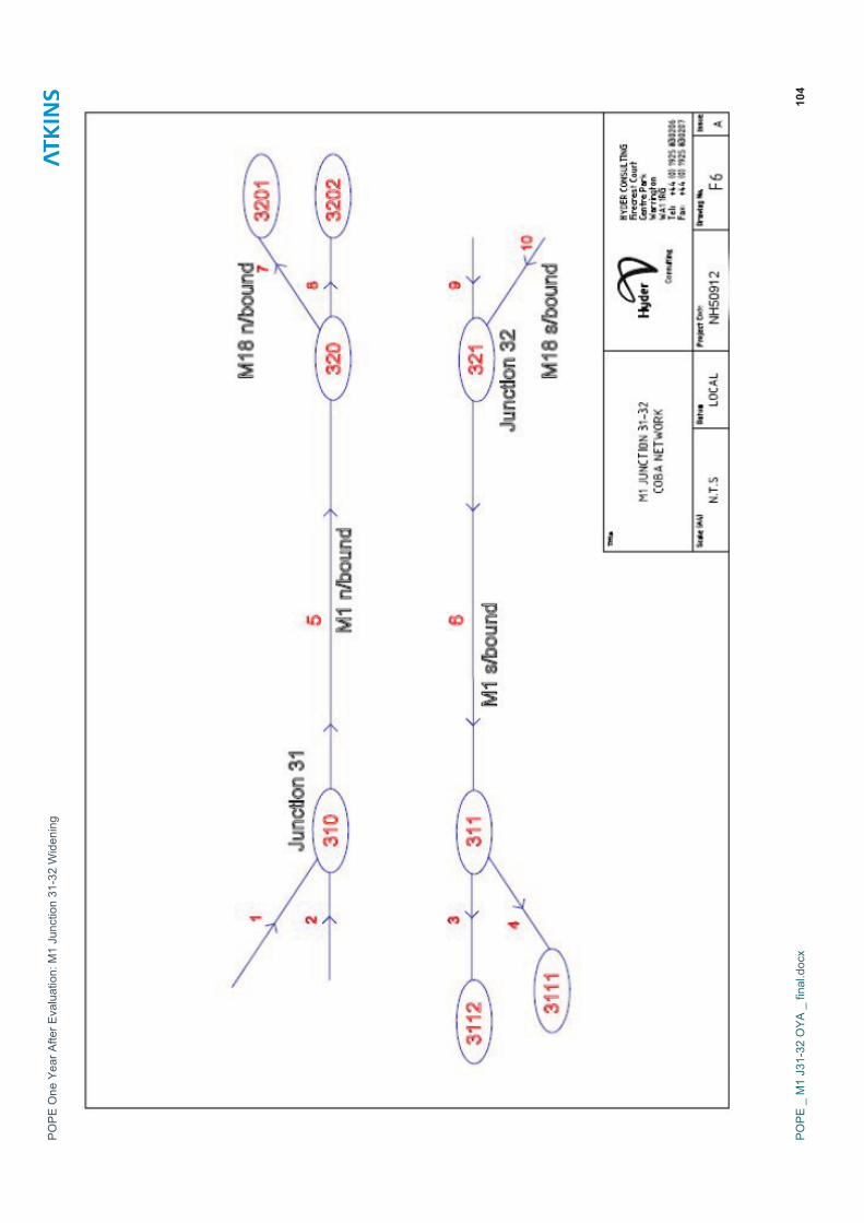
Appendix F – OPR COBA Network Diagram
PO
PE
One
Yea
r Afte
r Eva
luat
ion:
M1
Junc
tion
31-3
2 W
iden
ing
PO
PE
_ M
1 J3
1-32
OYA
_ fi
nal.d
ocx
104

POPE One Year After Evaluation: M1 Junction 31-32 Widening
POPE _ M1 J31-32 OYA _ final.docx
Appendix G – Calculation of Safety Benefits

POPE One Year After Evaluation: M1 Junction 31-32 Widening
POPE _ M1 J31-32 OYA _ final.docx
G.1 Calculation of Safety Benefits for M1 J31-32 Section Only
Number of Accidents
Fatal Serious Slight Total AA %KSI2004 0 1 4 5 1.42005 0 0 8 8 0.02006 0 0 6 6 6.3 0.02008 0 0 10 10 10 0.0
Opening Year Accident Saving -3.7
Average no. of accidents per year before construction 6.3Capitalisation factor to 60 years (motorway) 82.4No of accidents over 60 years without scheme 522
Average no of accidents per year on M1 J31-32 section after opening 10Capitalisation factor to 60 years (motorway) 82.4No of accidents over 60 years with widening scheme 824
Accident Saving Over 60 Years -302
Opening Yr value of PIA £83,400Opening Yr accident benefit -£305,80060 yr capitalisation factor 72.2660 yr accident benefit -£22,097,108Discount factor 0.814Safety PVB -£17,987,046

POPE One Year After Evaluation: M1 Junction 31-32 Widening
POPE _ M1 J31-32 OYA _ final.docx
G.2 Calculation of Safety Benefits for Revised Accident Area
Number of Accidents
Fatal Serious Slight Total AA %KSI2004 0 5 66 71 7.02005 1 1 77 79 2.82006 2 6 77 85 78.3 11.32008 1 6 57 64 64 9.9
Opening Year Accident Saving 14.3
Average no. of accidents per year before construction 78.3Capitalisation factor to 60 years (motorway) 82.398No of accidents over 60 years without scheme 6454.51
Average no of accidents per year in revised accident area after opening 64Capitalisation factor to 60 years (motorway) 82.398No of accidents over 60 years with widening scheme 5273.472
Accident Saving Over 60 Years 1181
Opening Yr value of PIA £83,400Opening Yr accident benefit £1,195,40060 yr capitalisation factor 72.2660 yr accident benefit £86,379,604Discount factor 0.814Safety PVB £70,312,998

POPE One Year After Evaluation: M1 Junction 31-32 Widening
POPE _ M1 J31-32 OYA _ final.docx
Appendix H – Economy Calculations
POPE One Year After Evaluation: M1 Junction 31-32 Widening
POPE _ M1 J31-32 OYA _ final.docx
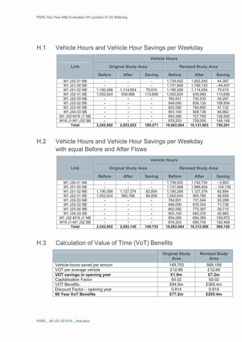
H.1 Vehicle Hours and Vehicle Hour Savings per Weekday
Vehicle Hours
Original Study Area Revised Study Area Link
Before After Saving Before After Saving M1 J30-31 NB - - - 1,736,932 1,692,545 44,387 M1 J31-30 SB - - - 1,731,668 1,796,125 - 64,457 M1 J31-32 NB 1,190,268 1,114,654 75,615 1,190,268 1,114,654 75,615 M1 J32-31 SB 1,052,624 938,968 113,656 1,052,624 938,968 113,656 M1 J32-33 NB - - - 784,831 730,535 54,297 M1 J33-32 SB - - - 948,090 839,135 108,954 M1 J33-34 NB - - - 802,082 754,950 47,132 M1 J34-33 SB - - - 903,100 808,138 94,962
M1 J32-M18 J1 NB - - - 854,266 727,759 126,508 M18 J1-M1 J32 SB - - - 878,203 729,055 149,148
Total 2,242,892 2,053,622 189,271 10,882,064 10,131,863 750,201
H.2 Vehicle Hours and Vehicle Hour Savings per Weekday with equal Before and After Flows
Vehicle Hours
Original Study Area Revised Study Area Link
Before After Saving Before After Saving M1 J30-31 NB - - - 1,736,932 1,742,734 - 5,803 M1 J31-30 SB - - - 1,731,668 1,866,404 - 134,736 M1 J31-32 NB 1,190,268 1,127,374 62,894 1,190,268 1,127,374 62,894 M1 J32-31 SB 1,052,624 965,766 86,858 1,052,624 965,766 86,858 M1 J32-33 NB - - - 784,831 731,544 53,288 M1 J33-32 SB - - - 948,090 876,354 71,736 M1 J33-34 NB - - - 802,082 772,367 29,715 M1 J34-33 SB - - - 903,100 840,235 62,865
M1 J32-M18 J1 NB - - - 854,266 694,395 159,872 M18 J1-M1 J32 SB - - - 878,203 695,734 182,469
Total 2,242,892 2,093,140 149,753 10,882,064 10,312,906 569,158
H.3 Calculation of Value of Time (VoT) Benefits
Original Study Area
Revised Study Area
Vehicle-hours saved per annum 149,753 569,158 VOT per average vehicle £12.66 £12.66 VOT savings in opening year £1.9m £7.2m Capitalisation Factor 50.02 50.02 VOT Benefits £94.8m £360.4m Discount Factor – opening year 0.814 0.814 60 Year VoT Benefits £77.2m £293.4m

POPE One Year After Evaluation: M1 Junction 31-32 Widening
POPE _ M1 J31-32 OYA _ final.docx
H.4 Present Value of Benefits for M1 J31-32 Widening Scheme (£Ms in 2002 prices)
Predicted OutturnSource of Benefit
AST OPRCOBA
Revised COBA
OriginalStudy Area
Revised Study Area
Value of Time Benefits £329.0 £180.1 £77.2 £293.4 Vehicle Operating Cost - £17.9 - £15.4 - £15.4 - £15.4 QUADRO Benefits
£308.2- £4.1 - £4.1 - £4.1 - £4.1
Accident Benefits -£11.4 - £11.4 - £3.7 - £18.0 £70.3 Total PVB £296.8 £295.6 £157.2 £39.7 £344.2

POPE One Year After Evaluation: M1 Junction 31-32 Widening
POPE _ M1 J31-32 OYA _ final.docx
Appendix I – Environmental Evaluation

POPE One Year After Evaluation: M1 Junction 31-32 Widening
POPE _ M1 J31-32 OYA _ final.docx
I.1 Introduction I.1.1 This report forms an Appendix to the Post Opening Project Evaluation One
Year After Study for the M1 Junction 31 – 32 Widening Scheme and documents the evaluation of the Environmental sub-objectives.
I.2 Data Collection I.2.1 The standard list of the background information requested and received for
this report is included in Table I.13 - Information Requested and Received at the end of this Appendix.
I.3 Site Visit I.3.1 A site visit was undertaken in July 2009 by a Landscape Architect. The
scheme was viewed both from within the highway estate and from adjacent local roads and footpaths. Photographs were taken and have been included within this document where appropriate.
I.4 Consultations I.4.1 Consultation has been carried out with the Statutory Bodies; Natural
England, English Heritage and the Environment Agency as well as Rotherham Metropolitan Borough Council and Sheffield City Council. Consultation sought to establish the opinions of the above on the impacts of the scheme together with their opinion as to whether mitigation measures have been effective. Not all of those contacted felt that they could comment on the scheme. Table I.1 is a summary of the consultees together with their responses.
Table I.1 – Summary of consultees and responses received
Organisation Field of Interest Response
Natural England Landscape and Biodiversity
Was unable to provide a response was not familiar with the scheme. Suggested contacting Rotherham MBC.
English Heritage Heritage EH could not provide comment as the scheme was deferred to Local Authority previously.
Environment Agency
Biodiversity & Water
Response received: Biodiversity - not aware of any impacts on biodiversity but have not actively monitored the area. Environmental Management - Not detected any improvement from pollution abatement measures as yet.Groundwater & Contamination - cannot confirm as yet if any issues

POPE One Year After Evaluation: M1 Junction 31-32 Widening
POPE _ M1 J31-32 OYA _ final.docx
Organisation Field of Interest Response have arisen. Other teams – Other teams within the EA had no adverse comments to make.
Rotherham MBC General
Not aware of any surveys having being carried out in respect of noise and air quality. Impacts considered as expected for listed buildings and conservation areas.
Sheffield CC General Did not feel it was able to make comment.
I.4.2 Further information on the responses received is contained within the specific topic sections in this report.
I.4.3 It is understood from the Highways Agency Part 1 Team that the Scheme is in the early stages of the claim period and it is not yet clear how many claims are likely to be successful. Information relating to Part 1 Claims will be included in the five year after evaluation.
I.5 Traffic Flows I.5.1 Three of the Environmental Sub-Objectives (noise, local air quality and
greenhouse gases) are directly linked to traffic flows. If the observed level of traffic is as that forecasted it can be assumed that the traffic noise and local air quality impacts are as expected.
I.5.2 Traffic volumes along the M1 and around junction 31 were predicted to change by between 0 and 11% due to scheme improvements. Traffic speeds were predicted to change very slightly on some links. The percentage of HGVs was not predicted to change.
I.5.3 The CSR assumed that the widened section would be completed in 2007, with a scheme design year 2022. High growth traffic flows were used in the report to provide a ‘worst case’ scenario. Figures are included in Table I.2.
Table I.2 - Traffic Forecast Figures included within the Confirmatory Studies Report (2005)
Monitoring Point Locations 2004 (Base Year) 2007 (Opening
year) 2022 (Design
year)
M1 Mainline 133,463 146,158 173,409
A57 (East of M1) 30,053 33,223 41,367
A57 (West of M1) 32,629 33,013 33,667
I.5.4 At the time of writing this report there was no traffic data available for the A57 monitoring points after completion of the scheme. Comparison of
POPE One Year After Evaluation: M1 Junction 31-32 Widening
POPE _ M1 J31-32 OYA _ final.docx
predicted with actual traffic flows could be considered as part of the five year after evaluation subject to any data being available.
I.5.5 Based on before and after observed traffic flows for the M1 mainline between junctions 31 and 32, including the percentage of HGVs, traffic flows are less than expected in the CSR. The actual 2004 AADT figure was 133,090. Traffic growth increases were assumed whereas in reality, there has been negative traffic growth. From information within the Traffic chapter of the POPE it would also appear that no induced or reassigned traffic has occurred in connection with the widening scheme with the observed flows for 2008/09 being 130,932 AADT.
I.6 Noise Predicted Impacts
I.6.1 The AST stated that there would be no overall change in noise levels with the scheme compared to the ‘Do-minimum’ and that low noise surfacing and mounding was proposed.
Comparison of ES (1994) and Confirmatory Studies Report (2005) I.6.2 A comparison with the 1994 ES recorded that the scheme as proposed in
2005 would result in a reduction in effects mainly due to the inclusion of low noise surfacing. In the 1994 ES it was anticipated that 9 dwellings would be eligible under the requirements of the Noise Insulation Regulations 1975 (as amended 1988). In the 2005 assessment it was predicted that as a result of mitigation that it was unlikely that any properties would be eligible.
I.6.3 Residential properties were considered the most sensitive receptors to the effects of road traffic noise in the 1994 ES, these were used as baseline ambient noise monitoring locations for the October 2005 surveys, the identified locations were: Woodville, Woodville Cottage, Vessey Close Cottages, Craiglea, Penny Hill and Brampton Villa.
Noise Level Changes I.6.4 The results of the traffic noise assessment concluded that without the
scheme, there would be a general rise in noise levels for all receptors of up to 0.5 dB LA10, 18-hour dB by 2022 due to expected traffic growth.
I.6.5 With the Scheme the operation of an extra lane would lead to the road moving slightly closer to some properties. It was predicted that at both opening (2007) and design (2022) years that increases would occur at some properties towards the southern end of the scheme of up to 0.5 LA10, 18-hour dB. It was assessed that this would not be perceptible to the residents of the properties.
I.6.6 Some properties towards the northern end of the scheme would undergo decreases in LA10, 18hour dB of up to 3 dB as a result of the scheme.

POPE One Year After Evaluation: M1 Junction 31-32 Widening
POPE _ M1 J31-32 OYA _ final.docx
Noise Nuisance I.6.7 All the properties would experience a decrease or no change in nuisance
levels with the scheme.
VibrationI.6.8 No properties were close enough to the scheme to be susceptible to
ground borne vibration effects, and vibration from air-borne low frequency noise was also not considered to be significant.
Approved Scheme
I.6.9 It was proposed that where the road was widened it would be surfaced with a low noise surface, which would result in a decrease in noise towards the northern end.
I.6.10 The 1994 ES proposed an earthbund immediately to the south of Vessey Close Farm overbridge, which would be 2m in height by 240m in length. It was predicted that this would shield some traffic noise from Vessey Close Cottages and Vessey Close Farm. An Environmental Bund is shown on the Environmental Objectives Sheet in the Confirmatory Studies Report (2005) between chainages 2300 and 2540 on the southbound side of the motorway estate.
Modification to Scheme
I.6.11 No noise specific modifications recorded.
Consultation Comments
I.6.12 Rotherham MBC is not aware of any surveys being carried out in respect of noise. No further responses in respect of noise are anticipated.
Key Findings
I.6.13 It was confirmed during the site visit and from as built drawings that the Environmental Bund has been constructed in the location anticipated in the before scheme studies. Figure I.1 shows the Environmental Bund, together with the planting.
I.6.14 It was confirmed with the Area 12 Mac that low noise surfacing has been added to this section of the motorway.
I.6.15 Traffic levels are less than forecast, and slightly less than actual flows before the improvements. Further information would be required to confirm noise levels at particular receptors but based on traffic flows the local noise climate should be no worse than before the scheme and may be better than expected although further study would be required to confirm this.

POPE One Year After Evaluation: M1 Junction 31-32 Widening
POPE _ M1 J31-32 OYA _ final.docx
Table I.3 - Evaluation of Noise Sub Objective against AST
Origin of Assessment
Summary of Predicted Effects Assessment
AST
No overall change in noise levels with the scheme compared to the ‘Do-minimum’. Low noise surfacing and mounding proposed
Quantitative Measure: Do-Minimum 67 Do-Something 67
0
EST
Noise mound and low noise surface provided as expected, Based on traffic flows which are slightly less than before the improvements and also less than forecast the local noise climate should be no worse than before the scheme and may be better than expected
As Expected and possibly better than expected
Figure I.1 - Environmental Bund Located to the South of Vessey Close Farm Overbridge

POPE One Year After Evaluation: M1 Junction 31-32 Widening
POPE _ M1 J31-32 OYA _ final.docx
I.7 Local Air Quality Predicted Effects
I.7.1 The AST stated that the air quality assessment indicated a very slight increase in the roadside concentrations of both PM 10 and NO2. NO2 concentrations would be in excess of Air Quality Standards (AQS) in the 0 to 100m bands. Two properties would fall within the predicted exceedance of the NO2 AQS.
I.7.2 There were no AQMA identified between junctions 31 and 32 of the M1 at the time of the 2005 assessment. A comparison between both ‘Do-Minimum’ and ‘Do-Something’ schemes indicated less than 1% variation in ambient air concentrations for all years considered as part of the assessment.
I.7.3 The localised, generalised and regional assessments indicated that little change in air quality was expected from the proposed widening of the M1 in comparison to the existing situation.
Approved Scheme including Mitigation Measures
I.7.4 The assessment was based on the widening of the M1 Motorway between junction 31 and 32 from a 3 lane to a 4 lane motorway in both directions. It was stated in the 2005 assessment that based on the modelling results that detailed assessment was not required for the CSR assessment; however that air quality monitoring was recommended for NO2 for the period between autumn and winter 2005 for one year. It was considered that no scheme specific mitigation measures were required.
Modification to Scheme
I.7.5 No air quality specific modifications recorded.
Consultation Comments
I.7.6 Rotherham MBC is not aware of any surveys being carried out in respect of Local Air Quality. No further responses in respect of noise are anticipated.
Key Findings
I.7.7 The local authority is not aware of any air quality monitoring having been undertaken and no other air quality information has been available for this report. It is suggested that the local authority is contacted for the five year after evaluation to confirm whether any monitoring has subsequently been required. Based on observed traffic flows it is considered that impacts associated with air quality could be better than expected although further study would be required to confirm this.

POPE One Year After Evaluation: M1 Junction 31-32 Widening
POPE _ M1 J31-32 OYA _ final.docx
Table I.4 - Evaluation of Air Quality Sub Objective against AST
Origin of Assessment
Summary of Predicted Effects Assessment
AST
The air quality assessment indicates a very slight increase in the roadside concentrations of both PM 10 and NO2. NO2concentrations are in excess of AQS in the 0 to 100m bands. Two properties fall within the predicted exceedance of the NO2 AQSThe Quantitative Measure noted that the net number of properties experiencing a change in PM10would be 10 and NO2 would be 10
Overall assessment score: PM10 = 0.07 N02 = 0.09
ESTBased on traffic flows which are less than forecast the local air quality may be better than expected.
Possibly Better than Expected
I.8 Greenhouse GasesPredicted Effects
I.8.1 A comparison between both ‘Do-Minimum’ and ‘Do-Something’ schemes indicated that there would be a change in CO2 emissions from 44,448 tonnes in the Do Minimum to 44,876 in the Do Something, a net increase of 428 tonnes.
I.8.2 The localised, generalised and regional assessments indicated that the change in greenhouse gas emission was expected from the proposed widening of the section due to increase in speeds.
Approved (Assessed) Scheme including Mitigation Measures
I.8.3 The assessment was based on the widening of the M1 Motorway between junction 31 and 32 from a 3 lane to a 4 lane motorway in both directions. It was stated in the 2005 assessment that based on the modelling results and advice from the Highways Agency that air quality monitoring was recommended for CO2. This monitoring takes the form of an assessment of traffic volume and speed and these factors have been monitored and used in this evaluation.
Modification to Scheme
I.8.4 No Greenhouse Gas specific modifications recorded.
Consultation Comments
I.8.5 Rotherham MBC is not aware of any surveys being carried out in respect of greenhouse gases. No further responses in respect of noise are anticipated.

POPE One Year After Evaluation: M1 Junction 31-32 Widening
POPE _ M1 J31-32 OYA _ final.docx
Key Findings
I.8.6 Using the greenhouse gases sub objective guidance in WebTAG, CO2 reforecast CO2 emissions have been calculated for the M1 J31-32 widened section only and the revised wider study area.
I.8.7 For the widened section only, the DM Carbon emissions are +18,900 and for the DS +18,990. This equates to an increase in carbon emissions of 90 tonnes. For the revised study area, the DM Carbon emissions are +92,551 and +93,453 for the DS. This equates to an increase in carbon emissions of 90 tonnes.
Table I.5 - Evaluation of Greenhouse Gases Sub Objective against AST
Origin of Assessment
Summary of Predicted Effects
Assessment
AST
There would be an overall increase in CO2emissions from the major road networks Quantitative Measure: +44,448 Do Minimum +44,876 Do Something
+428 Tonnes
EST
There is an increase in overall CO2 emissions from the +18,900 Do Minimum, +18,990
+90 Tonnes
I.9 Landscape Predicted Effects
I.9.1 The AST stated that in Winter Year 1 there would be an adverse impact on landscape local character, as a result of the loss of existing vegetation and the introduction of gantries. Areas of removed vegetation would be replaced and further enhanced by proposed planting measures. Mitigation planting would generally reduce the visual impact from all visual receptors, although most would still experience a barely perceptible deterioration in their view. The overall impact was predicted to be slight adverse.
Comparison of ES (1994) and Confirmatory Study (2005)
I.9.2 The CSR concluded that the landscape effects identified within the ES resulting from the widening of the carriageway and the loss of planting were generally still appropriate.
Visual Intrusion
I.9.3 The widening of the carriageway would have only a slight impact on landscape and visual receptors, with most of the intrusion resulting from the addition of the lighting columns and gantries. Existing night-time views from the settlements, including the village of Ulley, included headlights from the
POPE One Year After Evaluation: M1 Junction 31-32 Widening
POPE _ M1 J31-32 OYA _ final.docx
existing traffic within the motorway corridor. It was expected that the proposed cut-off lighting would increase light levels marginally.
I.9.4 The existing route was assessed overall as not highly visible and that the changes would be minimal. A total of nine visual receptors were identified, three were predicted to experience moderate adverse visual impacts in the first year of the works;
� Craig – Lea to Haven (10 properties), Worksop Road, Aston;
� Croft Farm, Aston; and
� Ulley Beeches, High Lane.
I.9.5 It was noted that users of High Lane route (parallel to motorway from bridge to Ulley Beeches) experienced substantial visual intrusion which would hardly be altered as a result of the proposals.
Landscape Character
I.9.6 The landscape was assessed as ‘good’ in the CSR noting that the area to the west of the motorway was designated as an ‘Area of County Landscape Value’. It was concluded that there would be a slight adverse, short to medium term, impact on the landscape mainly as a result of the lighting columns. However it was assessed that the effect would be mitigated in parts by the existing and proposed vegetation.
I.9.7 It was predicted that vegetation loss would be required to the bottom of the slopes between Junction 31 and Vessey Close Farm as a result of the construction of retaining structures. This loss of existing vegetation was expected to have a slight adverse impact on landscape character.
Approved Scheme including Mitigation Measures
I.9.8 The scheme was designed to minimise light pollution at the request of the then Countryside Agency (now Natural England). It was also proposed that the extent of lighting would be minimised by the use of lanterns with full cut-off capability.
I.9.9 Proposed planting locations included, near Vessey Close Farm Overbridge. It was considered that the proposed environmental bund and planting near Vessey Close Farm overbridge would improve views from the Vessey Close Farm and Cottages.
I.9.10 Off site planting was suggested in the 2005 assessment as desirable at two locations to minimise the visual impacts of the scheme from the village of Ulley and Vessey Close Cottages;
� to the south of Vessey Farm Overbridge east of the carriageway; and
� off High Lane, near Ulley Beeches west of the carriageway.
I.9.11 It was stated within the ES that existing planting to be retained should be protected by temporary fencing during construction. It was reported in the
POPE One Year After Evaluation: M1 Junction 31-32 Widening
POPE _ M1 J31-32 OYA _ final.docx
Environmental Action Plan that during site establishment areas of habitat and plants would be cordoned off to prevent damage from machinery and stockpiled material and this would be monitored on a weekly basis. Existing vegetation would appear to have been retained as expected.
Modification to Scheme
I.9.12 During the site visit it was recorded that lighting was not included in the widening scheme. It is noted that this is taken into account in the 2006 AST.
Consultation Comments
I.9.13 Natural England felt unable to provide feedback as it was not familiar with the scheme.
Key Findings
Visual Intrusion
I.9.14 Two photomontages were included within the Environmental Statement (1994), and are shown in Figures I2 and I3 overleaf.
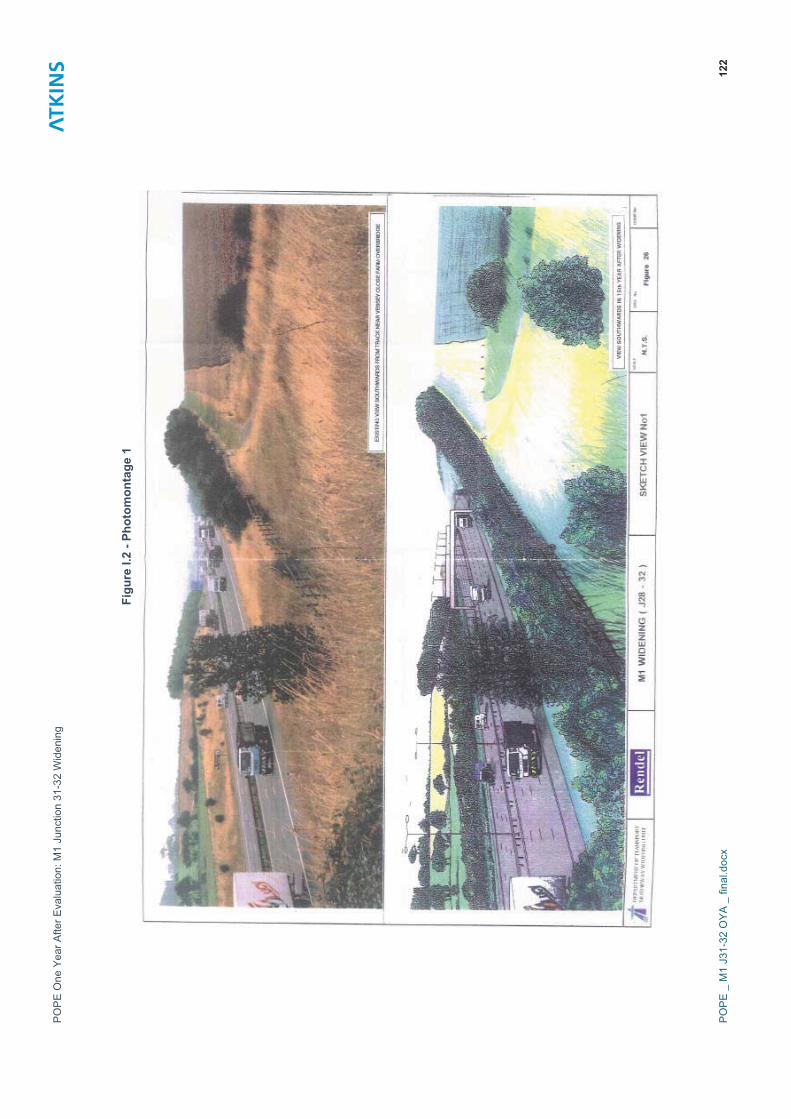
PO
PE
One
Yea
r Afte
r Eva
luat
ion:
M1
Junc
tion
31-3
2 W
iden
ing
PO
PE
_ M
1 J3
1-32
OYA
_ fi
nal.d
ocx
122
Fig
ure
I.2 -
Phot
omon
tage
1

PO
PE
One
Yea
r Afte
r Eva
luat
ion:
M1
Junc
tion
31-3
2 W
iden
ing
PO
PE
_ M
1 J3
1-32
OYA
_ fi
nal.d
ocx
123
Fig
ure
I.3 -
Phot
omon
tage
2

POPE One Year After Evaluation: M1 Junction 31-32 Widening
POPE _ M1 J31-32 OYA _ final.docx 124
I.9.15 During the site visit photographs (Figures I.4 and I.5) were taken from these viewpoints for comparison. The photographs illustrate that the proposed scheme generally appears as was expected with the exception that lighting has not been included. This change to in original scheme was noted in the 2006 version of the AST.
I.9.16 During the summer 2009 site visit the visual impact at receptors noted in the Confirmatory Studies was evaluated these are shown in Table I.6. It would be appropriate to re-visit these locations for the five year after study.
I.9.17 It is considered that the environmental mounding provided near Vessey Close Farm overbridge does improve views from Vessey Farm as expected. New planting has been provided and is establishing satisfactorily. The ongoing establishment and effectiveness of this as a screening measure would need to be confirmed during the five year after study. Figures I.6 and I.7 illustrate the screening provided by existing vegetation within the highway boundary located to the west of the motorway near Junction 31.
Table I.6 - Evaluation of Predicted Effects on Visual Receptors
Visual Receptor Predicted Impact Year 1 Evaluation
Craig – Lea to Haven, Worksop Road, Aston.
10 no. Residential properties
Some loss of vegetation and view of wider carriageway, 1 new gantry and new lighting. Views of lighting and gantries more evident in winter. Noticeable deterioration in view
Moderate Adverse
Lighting not included within constructed scheme.Vegetationretained as part of the Scheme to the west of the carriageway. Glimpsed views of gantries maybe visible.
Better than Expected in originalassessment but As Expected in AST 2006 version
Croft Farm, Aston. Farmhouse
Some loss of vegetation and view of wider carriageway, 1 new gantry and new lighting. Visual detractors more evident in Winter.
Moderate Adverse
Lighting not included within constructed scheme.Vegetationretained as part of the Scheme to the west of the carriageway. Glimpsed views of gantries maybe visible.
Better than Expected in originalassessment but As Expected in AST 2006 version
UlleyBeeches, High Lane.
Residential property
Proposed lighting columns and 3 gantries visible. Traffic visible closer to the property. Noticeable deterioration in the existing view
Moderate Adverse
Lighting not included within constructed scheme.Glimpsed views of gantries maybe visible.
Better than Expected in originalassessment but As Expected in AST 2006 version
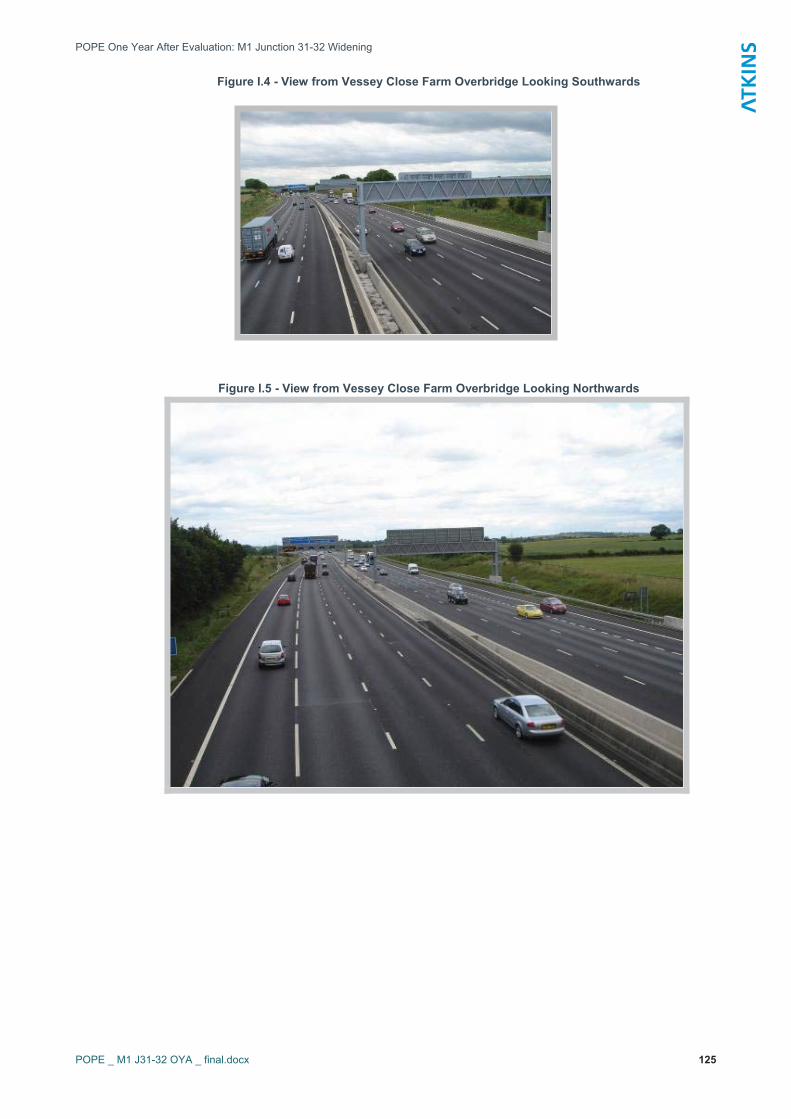
POPE One Year After Evaluation: M1 Junction 31-32 Widening
POPE _ M1 J31-32 OYA _ final.docx 125
Figure I.4 - View from Vessey Close Farm Overbridge Looking Southwards
Figure I.5 - View from Vessey Close Farm Overbridge Looking Northwards
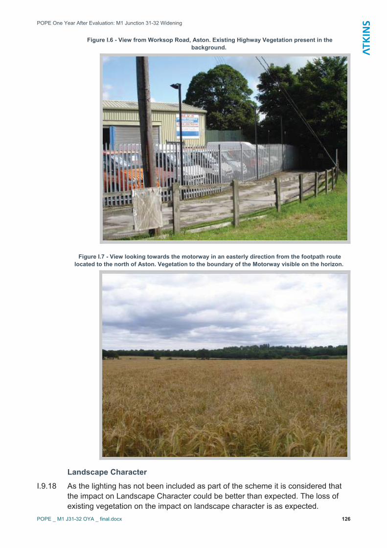
POPE One Year After Evaluation: M1 Junction 31-32 Widening
POPE _ M1 J31-32 OYA _ final.docx 126
Figure I.6 - View from Worksop Road, Aston. Existing Highway Vegetation present in the background.
Figure I.7 - View looking towards the motorway in an easterly direction from the footpath route located to the north of Aston. Vegetation to the boundary of the Motorway visible on the horizon.
Landscape Character
I.9.18 As the lighting has not been included as part of the scheme it is considered that the impact on Landscape Character could be better than expected. The loss of existing vegetation on the impact on landscape character is as expected.

POPE One Year After Evaluation: M1 Junction 31-32 Widening
POPE _ M1 J31-32 OYA _ final.docx 127
I.9.19 It was predicted that vegetation loss would occur to the bottom of the slopes between the Junction 31 and Vessey Close Farm as a result of the construction of retaining structures. Figure I.8 illustrates the typical ground retention, using Soil Nailing, and existing vegetation retained along the section of the scheme between Junction 31 and 32 and the extent of vegetation loss. The ongoing establishment of seeding on the soil nailed slopes and adjacent planting should be evaluated during the five year after study.
I.9.20 Planting within the highway estate has been undertaken as expected and in line with that proposed in the CSR figures and it is generally establishing satisfactorily and providing a framework for the road. Stakes, ties and guards are present on most plants and it was noted that maintenance is being undertaken (Figure I.9). However, there is some noxious weed growth present. Ongoing establishment of planting and seeding should be evaluated as part of the five year after study.
I.9.21 The Employers Agent confirmed that off site planting by agreement has not been required and suggested this could be due to the bunds included in the scheme. The fact that lighting did not form part of the final design might also be a consideration.
I.9.22 The Tree Windthrow Risk Assessment undertaken in December 2005, recommended that prior to the handover of the landscape and tree works a condition inspection of retained trees be undertaken to ensure that decay, structural faults or construction damage to roots and stems had not impaired tree stability. Confirmation is being sought as to whether this was undertaken and will be included within this report when received.
I.9.23 Subject to successful ongoing establishment of retained and new planting, and seeding it is considered at the one year after stage that the impacts are as expected. Establishment of the planting and seeding should be reviewed as part of the five year after report.

POPE One Year After Evaluation: M1 Junction 31-32 Widening
POPE _ M1 J31-32 OYA _ final.docx 128
Figure I.8 - The retention of existing vegetation adjacent to the soil nailed section of ground located between Junction 31 and Vessey Close Farm
Figure I.9 - Establishment of planting on the Motorway Embankment

POPE One Year After Evaluation: M1 Junction 31-32 Widening
POPE _ M1 J31-32 OYA _ final.docx 129
Table I.7 - Evaluation of Landscape Sub Objective against AST
Origin of Assessment
Summary of Predicted Effects Assessment
AST
Winter Year 1 adverse impact on landscape local character, as a result of the loss of existing vegetation and the introduction of gantries. Areas of removed vegetation will be replaced and further enhanced by proposed planting measures. Mitigation planting will generally reduce the visual impact from all visual receptors, although most will still experience a barely perceptible deterioration in their view.
Slight Adverse
EST
New planting has been provided within the motorway estate and is establishing satisfactorily. Existing planting has been retained where possible. The lighting proposed as part of the initial Scheme was later omitted and this was taken into account in the AST used for this report. Overall the evaluation is considered to be as expected in the AST but better than expected within the ES.
Likely to be As Expected
I.10 Cultural Heritage Predicted Impacts
I.10.1 The AST stated that there would be a slight increase in visual impact at two Grade II listed buildings and the two conservation areas of Ashton and Brampton-en-le-Morthern with a slight adverse impact predicted overall.
Comparison of ES (1994) and Confirmatory Study Report (2005)
I.10.2 The conclusions of the ES, which stated that ‘no sites of historical or cultural interest would be affected; remained the same after the re-assessment reported in the CSR.
I.10.3 The CSR contained a summary of the Cultural Heritage Desk Based Assessment published in 2003, which included consultations with English Heritage, South Yorkshire Archaeology Service and Rotherham Metropolitan Borough Council.
Conservation Areas
I.10.4 It was predicted that both Aston and Brampton-en-le-Morthen conservation areas would experience minimal impacts and would be unaffected by the construction works.
I.10.5 At the time of writing the confirmatory study a new Conservation Area, Ulley, was being considered for designation by Rotherham MBC, this area was located 1.5km from the motorway corridor.
Listed Buildings
I.10.6 A total of 42 listed buildings were identified within the study area, however impacts were only predicted for one of them, a Dovecote (Grade II Listed), at
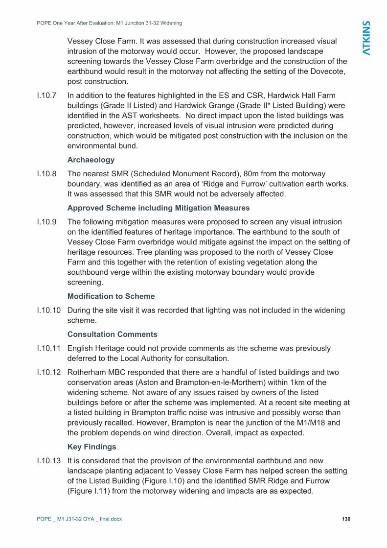
POPE One Year After Evaluation: M1 Junction 31-32 Widening
POPE _ M1 J31-32 OYA _ final.docx 130
Vessey Close Farm. It was assessed that during construction increased visual intrusion of the motorway would occur. However, the proposed landscape screening towards the Vessey Close Farm overbridge and the construction of the earthbund would result in the motorway not affecting the setting of the Dovecote, post construction.
I.10.7 In addition to the features highlighted in the ES and CSR, Hardwick Hall Farm buildings (Grade II Listed) and Hardwick Grange (Grade II* Listed Building) were identified in the AST worksheets. No direct impact upon the listed buildings was predicted, however, increased levels of visual intrusion were predicted during construction, which would be mitigated post construction with the inclusion on the environmental bund.
Archaeology
I.10.8 The nearest SMR (Scheduled Monument Record), 80m from the motorway boundary, was identified as an area of ‘Ridge and Furrow’ cultivation earth works. It was assessed that this SMR would not be adversely affected.
Approved Scheme including Mitigation Measures
I.10.9 The following mitigation measures were proposed to screen any visual intrusion on the identified features of heritage importance. The earthbund to the south of Vessey Close Farm overbridge would mitigate against the impact on the setting of heritage resources. Tree planting was proposed to the north of Vessey Close Farm and this together with the retention of existing vegetation along the southbound verge within the existing motorway boundary would provide screening.
Modification to Scheme
I.10.10 During the site visit it was recorded that lighting was not included in the widening scheme.
Consultation Comments
I.10.11 English Heritage could not provide comments as the scheme was previously deferred to the Local Authority for consultation.
I.10.12 Rotherham MBC responded that there are a handful of listed buildings and two conservation areas (Aston and Brampton-en-le-Morthern) within 1km of the widening scheme. Not aware of any issues raised by owners of the listed buildings before or after the scheme was implemented. At a recent site meeting at a listed building in Brampton traffic noise was intrusive and possibly worse than previously recalled. However, Brampton is near the junction of the M1/M18 and the problem depends on wind direction. Overall, impact as expected.
Key Findings
I.10.13 It is considered that the provision of the environmental earthbund and new landscape planting adjacent to Vessey Close Farm has helped screen the setting of the Listed Building (Figure I.10) and the identified SMR Ridge and Furrow (Figure I.11) from the motorway widening and impacts are as expected.
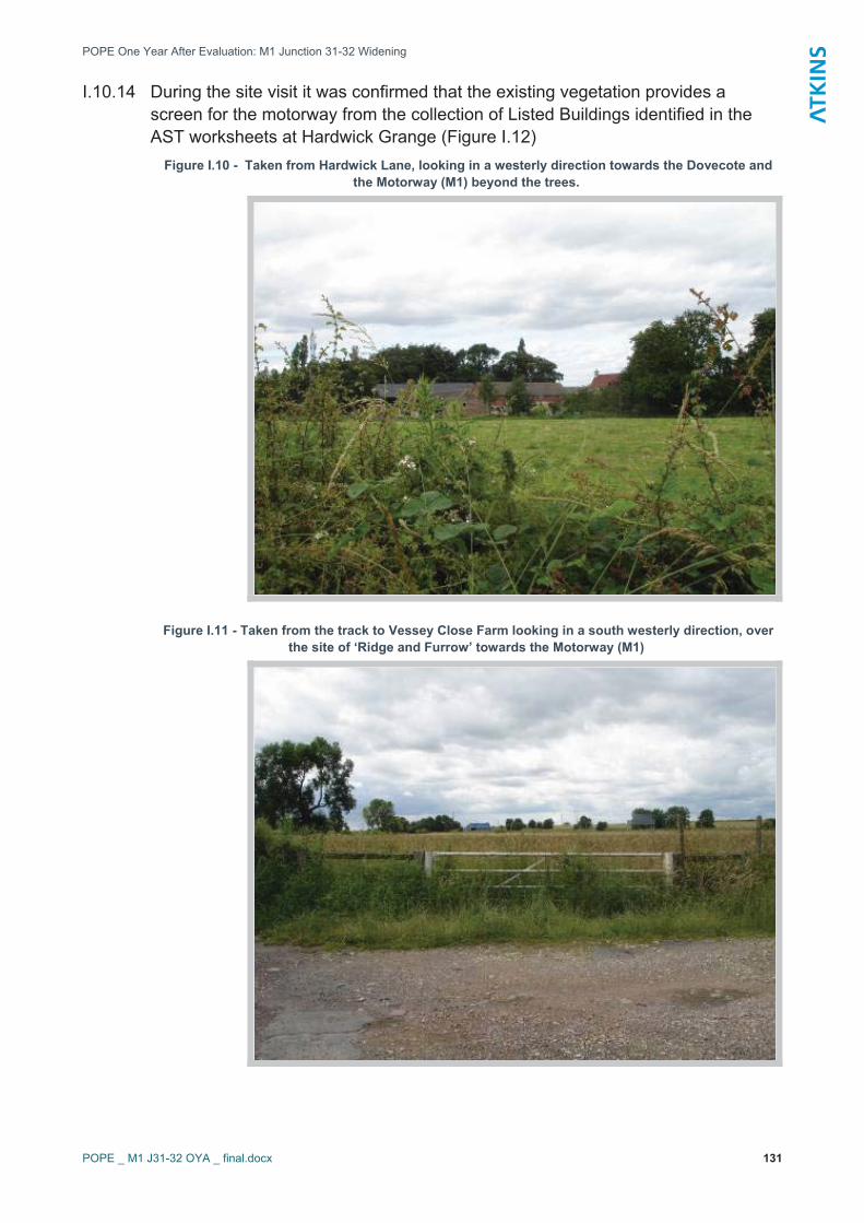
POPE One Year After Evaluation: M1 Junction 31-32 Widening
POPE _ M1 J31-32 OYA _ final.docx 131
I.10.14 During the site visit it was confirmed that the existing vegetation provides a screen for the motorway from the collection of Listed Buildings identified in the AST worksheets at Hardwick Grange (Figure I.12)
Figure I.10 - Taken from Hardwick Lane, looking in a westerly direction towards the Dovecote and the Motorway (M1) beyond the trees.
Figure I.11 - Taken from the track to Vessey Close Farm looking in a south westerly direction, over the site of ‘Ridge and Furrow’ towards the Motorway (M1)
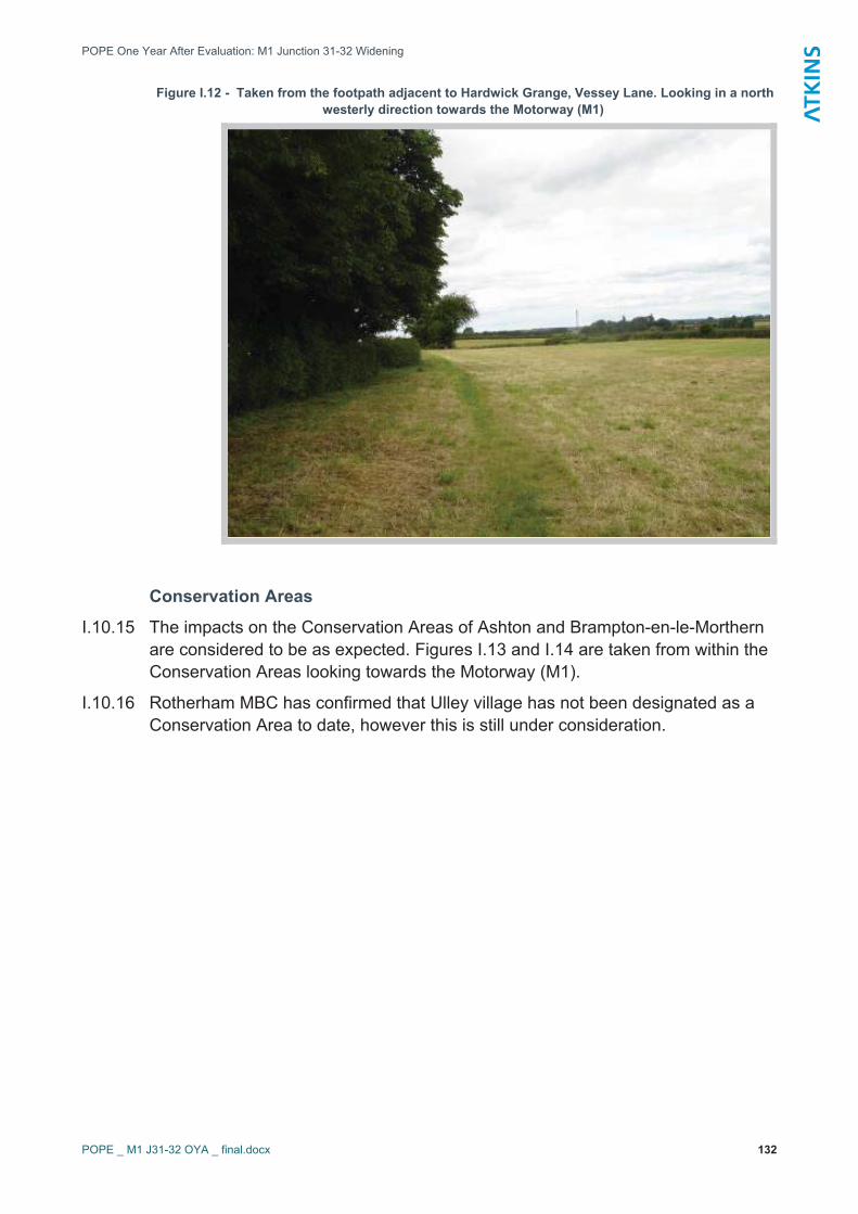
POPE One Year After Evaluation: M1 Junction 31-32 Widening
POPE _ M1 J31-32 OYA _ final.docx 132
Figure I.12 - Taken from the footpath adjacent to Hardwick Grange, Vessey Lane. Looking in a north westerly direction towards the Motorway (M1)
Conservation Areas
I.10.15 The impacts on the Conservation Areas of Ashton and Brampton-en-le-Morthern are considered to be as expected. Figures I.13 and I.14 are taken from within the Conservation Areas looking towards the Motorway (M1).
I.10.16 Rotherham MBC has confirmed that Ulley village has not been designated as a Conservation Area to date, however this is still under consideration.

POPE One Year After Evaluation: M1 Junction 31-32 Widening
POPE _ M1 J31-32 OYA _ final.docx 133
Figure I.13 - View looking in a south westerly direction towards the motorway (M1) from Toad Lane in Brampton-en-le-Morthen
Figure I.14 - View looking in a north easterly direction towards the Motorway (M1) from a public footpath route located on the eastern boundary of Ashton Conservation Area
POPE One Year After Evaluation: M1 Junction 31-32 Widening
POPE _ M1 J31-32 OYA _ final.docx 134
Table I.8 - Evaluation of Heritage Sub Objective against AST
Origin of Assessment
Summary of Predicted Effects Assessment
ASTSlight increase in visual impact at two Grade II listed buildings and two conservation areas of Ashton and Brampton-en-le-Morthern.
Slight adverse
EST
Any impacts on the setting of the identified sites of cultural heritage importance, Conservation Areas, Listed Buildings and the area of Ridge and Furrow are limited as expected - screened by retained planting northbound of Vessey Close Overbridge, and new planting within the highway estate and on the environmental bund
As Expected.
I.11 Biodiversity Predicted Impacts
I.11.1 The AST stated that the Scheme would result in slight adverse impacts on Brampton Common Site of Scientific Interest, motorway verges, planted broadleaved woodland, ruderal vegetation, relict magnesian limestone grassland and diverse ephemeral / short perennial flora. There was expected to be a slight adverse impacts on badgers and birds and neutral impacts on bats. Overall the impact was predicted to be slight adverse.
Comparison of ES (1994) and Confirmatory Studies (2005) I.11.2 Badgers were not highlighted as using the area in the ES, however they were
included within the CSR.
I.11.3 The survey work that formed part of the ES identified sneezewort being present within the Study Area. This was not reported in the CSR.
Confirmatory Studies 2005
I.11.4 It was stated that no statutory sites would be affected by the proposed works and it was predicted that the following impacts would occur;
� indirect impacts from the motorway run off affecting local watercourses of Ulley Brook and Ulley Beech Brook (non-statutory nature conservation sites);
� no direct or indirect impacts on Nickerwood and Rocky Bottom SSI, located to the southwest of Junction 31; and
� low adverse, short term effect on Brampton Common located north and east of Vessey Close farm overbridge. This was recorded as being of little ecological value within the Environmental Impact Table.
� The field study undertaken for the CSR found no ditches, slow flowing streams or ponds suitable for Water Voles that would be directly affected by

POPE One Year After Evaluation: M1 Junction 31-32 Widening
POPE _ M1 J31-32 OYA _ final.docx 135
the proposed widening. It was reported that due to the low availability of suitable habitat for this species the potential impacts were described as moderate and short term in nature.
I.11.5 One pond was highlighted within the ‘before studies’, as being situated within 50m to the east of the motorway, near to Vessey Close Farm. Table I.10 is an extract from the CSR and indicates the predicted impacts together with the recommended mitigation measures included within the Confirmatory Study.
Table I.10 - Predicted Biodiversity Impacts (From Confirmatory Studies Report, 2005)
Site/Species and Nature
Conservation Value
PotentialImpact(s)
Positive/ Negative
Significance of Impact
Comment
Non-statutory sites within the local area.
None identified. Potential impacts during construction identified in 1994 ES.
No Effect No Impact Local SSIs too far from the proposed route for any direct or indirect impacts to be likely.Adoption of good working practices as identified in the 1994 ES.
Relict Magnesian limestonegrassland.
Removal and encroachment from works.
Negative Minor Measures should be in place to ensure that the seed is collected from this site prior to works and re-sown in a nutrient poor sub soil following completion of works.
Diverse ephemeral short perennial.
Removal and encroachment from works.
Negative Minor As with relict Magnesian grassland.
Watercourses. Impacts on water quality, noise and dust pollution during construction.
Negative Minor The significance of this impact would be greatly reduced through good working practices.
Planted broad-leaved trees. Important habitat for local bird species.
Removal of some trees for carriageway widening.
Negative Minor Areas of trees provide important cover for a number of species. Some removal of trees is unavoidable and should be kept to a minimum. Clearance should take place outside the bird-nesting season to avoid disturbance to breeding birds.
Tall Ruderal grassland
Some removal and encroachment from works.
Negative Negligible Where possible areas resulting in loss of this grassland type should be re-seeded into nutrient poor sub soil using a seed-mix much the same as the structure of the relict Magnesian limestone grassland type.
Tall semi-improved grassland.
Some removal and encroachment from works
Negative Negligible As tall ruderal.

POPE One Year After Evaluation: M1 Junction 31-32 Widening
POPE _ M1 J31-32 OYA _ final.docx 136
Site/Species and Nature
Conservation Value
PotentialImpact(s)
Positive/ Negative
Significance of Impact
Comment
Great Crested Newts: Protected under the Wildlife & Countryside Act 1981 and EC legislation.
Impacts on water quality, removal of vegetation.
Negative Moderate Removal of vegetation adjacent to the pond and watercourses should be kept to a minimum. Potential hibernacula must be kept in situ. Amphibian fencing may be required.
Water Voles: Protected under the Wildlife & Countryside Act 1981.
Impacts on water quality, loss of habitat, disturbance during construction.
Negative Moderate The significance of this impact would be greatly reduced through good working practices. Removal of vegetation should be kept to a minimum.
Wild Birds:Including UK BAP Priority Species and BoCC red, amber and green listed species.
Disturbance during construction.
Negative Short-term
Moderate The significance of this impact would be greatly reduced through good working practices and appropriate timing of works. Temporary effects of disturbance during construction.
Badger: Protected under the Wildlife & Countryside Act 1981 and the Protection of Badgers Act 1992.
Disturbance of badger foraging area and possible sett.
Negative Short-term
Moderate Badgers known to be using small copse in study area. Surveys should be conducted prior to works to ensure no sett has been established.
Bats: Protected under the BERN Convention; the Wildlife & Countryside Act 1981; Schedule 2 of the Conservation (Natural Habitats) Regs 1994.
Disturbance to potential foraging area.
Negative Short-term
Moderate – Short Term
The significance of this impact would be greatly reduced through good working practices and appropriate timing of works.
Approved (Assessed) Scheme including Mitigation Measures
I.11.6 The mitigation measures recommended in the CSR were generally the requirement for the implementation of good working practices during the construction of the scheme including the retention of the maximum amount of habitat and a watching brief kept by a professional ecologist. Surveys for Great Crested Newts were also recommended.
I.11.7 Habitat creation is included on the Environmental Objective drawings in the form of areas of Conservation Grassland to be re-seeded using a seed mix with the same structure as the relict Magnesium Limestone Grassland type.
POPE One Year After Evaluation: M1 Junction 31-32 Widening
POPE _ M1 J31-32 OYA _ final.docx 137
Modification to Scheme
I.11.8 No specific modifications to the scheme have been confirmed in connection with the Biodiversity sub-objective.
Consultation Comments
I.11.9 The Environment Agency commented that they are not aware of any impacts on biodiversity but have not actively monitored the area.
I.11.10 Natural England was unable to provide any feedback as it was not familiar with the scheme or the local setting. NE suggested contacting the ecologist at Rotherham MBC. No comments were received and it is suggested that Rotherham MBC is consulted with again for the five year after report.
Key Findings
I.11.11 The following environmental measures were included within the Environmental Action Plan (part of the CEMP) and treatment of environmental areas programme:
� Check Vessey Close Bridge for the presence of Bats on a weekly basis;
� Check plantations and scrub for signs of badger activity on a weekly basis;
� Check woody vegetation for birds nest before felling in January 2007;
� Survey using Artificial Cover Objects to start in February or March 2007 prior to habitat clearance of excavation works, other than on mown verges, to determine the presence of GCNs;
� Erection of protective fencing and maintaining integrity of newt fencing on a weekly basis; and
� Top soil to be removed from grassland / botanically rich areas and stored to act as a seed bank for spreading on new slopes and verges. Re-plant similar assemblage of species of different ages. Re-seed embankments with calcareous grassland mixture, preferably sourced from a local magnesium limestone site, to mitigate for loss of degraded relict areas of magnesium limestone grassland.
I.11.12 Within the CEMP it was noted that the only Protected Species for which a risk had been identified was great crested newts but review of existing data identified a lack of information relating to the status of reptiles on the site and the CEMP suggested that until surveys were completed the precautionary principle required that this group was also treated as being at risk. During the CEMP survey work it was established that the pond, which lies 150m east of the motorway, held a small population of great crested newts. The road improvements required existing soft estate to be removed to accommodate the new carriageway. Existing terrestrial habitat linked the pond with the motorway verge so a DEFRA GCN development licence was obtained (WLF 024036).
I.11.13 It is understood that annual post opening monitoring to June 2010 is an obligation under the consent for the highway improvements and is being undertaken for Great Crested Newts at Vessey Farm Pond. It has been confirmed by the Employer’s Agent that field surveys were carried out between March and June

POPE One Year After Evaluation: M1 Junction 31-32 Widening
POPE _ M1 J31-32 OYA _ final.docx 138
2008. The surveys established that the pond is still being used by amphibians, including great crested newts. The records show that an increase in great crested newt population has occurred during the time since 2006. Based on the survey results to date it would appear that the mitigation measures have benefited the great crested newts and other amphibian populations. Results of the ongoing monitoring should be made available to inform the Five Year After evaluation.
I.11.14 Figure I.15, shows this pond in its context. Tall ruderal vegetation is present around the pond.
I.11.15 Based on the monitoring regime during construction included within the CEMP and the level of vegetation retention during the scheme it is likely that the impacts are as expected in respect of badgers.
I.11.16 In respect of bats none of the existing structures on the motorway were widened during the construction of the scheme. Vegetation loss is in line with that anticipated therefore it is likely that the impacts are as expected.
I.11.17 Animal mortality data has been received from the MAC. During the MAC commission (June 2003 to date) there have been a total of 4 recorded incidents on this section of the motorway. None of which have occurred after the opening of the widening scheme.
I.11.18 Based on the As-Built landscape plans and site visit it appears that the planting areas have generally been incorporated in line with the proposed mitigation measures. It has not been possible to evaluate the success of the establishment of the Magnesium Limestone grassland areas at this one year after stage (Figure I.16) as no survey information was made available to POPE.
I.11.19 Biodiversity should be further evaluated at the five year after stage when further monitoring information would be available. Rotherham MBC and the local Wildlife Trust should be consulted with for the five year after report.
Figure I.15 - Pond located to the east of the Motorway, within Vessey Close Farm
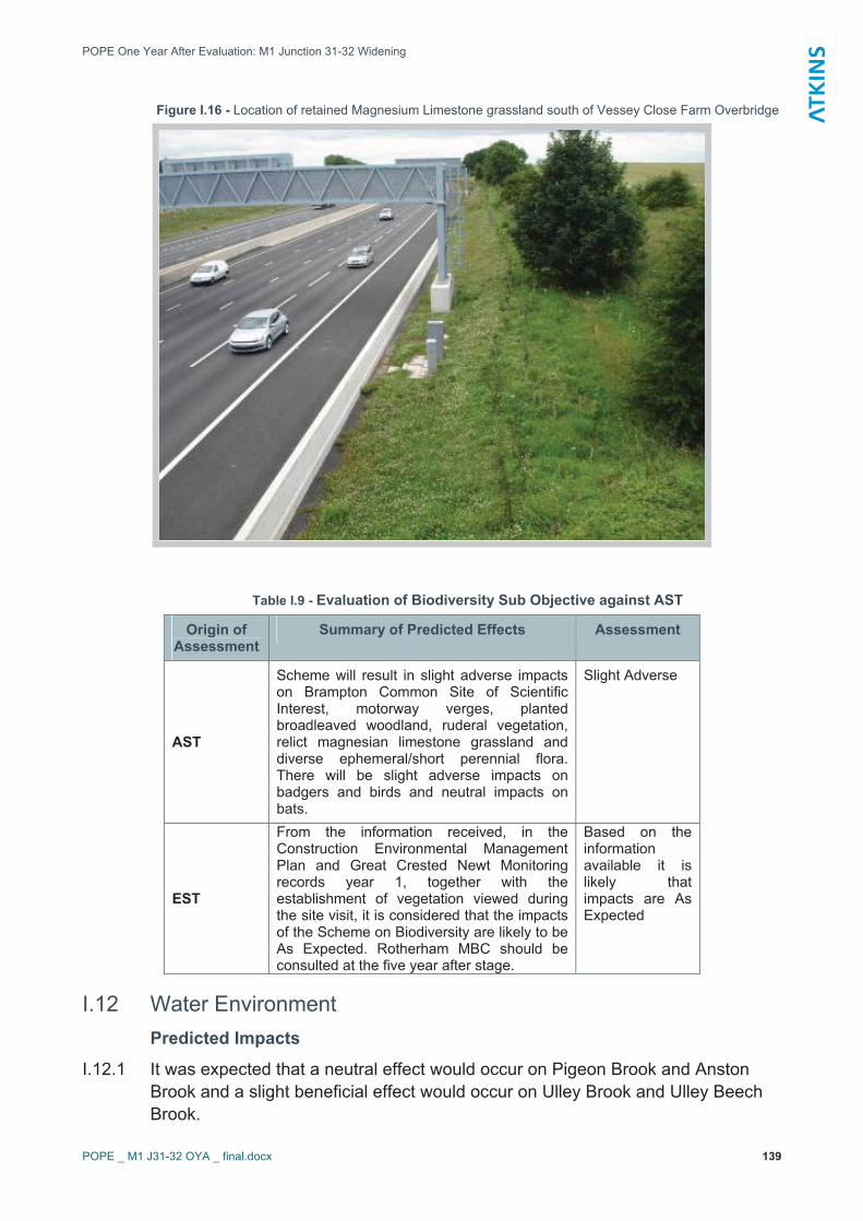
POPE One Year After Evaluation: M1 Junction 31-32 Widening
POPE _ M1 J31-32 OYA _ final.docx 139
Figure I.16 - Location of retained Magnesium Limestone grassland south of Vessey Close Farm Overbridge
Table I.9 - Evaluation of Biodiversity Sub Objective against AST
Origin of Assessment
Summary of Predicted Effects Assessment
AST
Scheme will result in slight adverse impacts on Brampton Common Site of Scientific Interest, motorway verges, planted broadleaved woodland, ruderal vegetation, relict magnesian limestone grassland and diverse ephemeral/short perennial flora. There will be slight adverse impacts on badgers and birds and neutral impacts on bats.
Slight Adverse
EST
From the information received, in the Construction Environmental Management Plan and Great Crested Newt Monitoring records year 1, together with the establishment of vegetation viewed during the site visit, it is considered that the impacts of the Scheme on Biodiversity are likely to be As Expected. Rotherham MBC should be consulted at the five year after stage.
Based on the informationavailable it is likely that impacts are As Expected
I.12 Water Environment Predicted Impacts
I.12.1 It was expected that a neutral effect would occur on Pigeon Brook and Anston Brook and a slight beneficial effect would occur on Ulley Brook and Ulley Beech Brook.

POPE One Year After Evaluation: M1 Junction 31-32 Widening
POPE _ M1 J31-32 OYA _ final.docx 140
I.12.2 The AST stated that there would be slight beneficial impacts on water quality on two watercourses and neutral impacts on two watercourses. The Scheme was not expected to increase the risk of flooding. The increase in surface runoff would be attenuated by a new infiltration pond. A slight beneficial impact was predicted overall.
Risk of Accidental Spillage
I.12.3 The calculations included as part of the 2005 confirmatory study identified that the probability of serious pollution incident occurring would be once in 67 years, less than the threshold. An acceptable risk was reported at the time of the ‘before studies’ as 1 in 50 years for watercourses, excluding sensitive watercourses and aquifers reported as 1 in 100years.
Ground Water
I.12.4 No Source Protection Zones within the study area and unlikely that significant impacts to groundwater would occur.
Drainage and Flooding
I.12.5 The proposed drainage system and pollution control measures included as mitigation would reduce the risks at the outfalls.
I.12.6 It was stated that the implementation of the proposed drainage system would have a net beneficial impact on operational discharges compared to the Do-minimum scenario.
Approved Scheme and Mitigation Measures
I.12.7 The following mitigation measures were proposed in the before scheme studies:
� Edge of pavement combined filter drains or kerb gullying connection to a carrier drain situated in the verge
� Storage pipes to temporarily retain flows in excess of existing flows for all rainfall events up to and including a 1 in 50 year return period.
� Oil interceptor with a integral silt trap at or near the outfall point with a minimum capacity of 20m3
� A penstock facility to permit isolation in the event of an accidental spillage
� A trapped outlet to the receiving ditch or stream course to retain silt and oils in the ditch
� A Penstock at each outlet to permit isolation in the event of an accidental spillage.
I.12.8 It was stated that the rainfall onto the carriageway would be removed by surface water channels at the edge of each carriageway, which would outfall into surface water pipes. Existing pipes would remain as part of the system where possible.
I.12.9 All the highway runoff from the widened section would be discharged into the existing outfall at Junction 31. It was proposed within the Confirmatory Studies Report that the pipes would outfall into an infiltration basin in the verge at the centre of Junction 31.
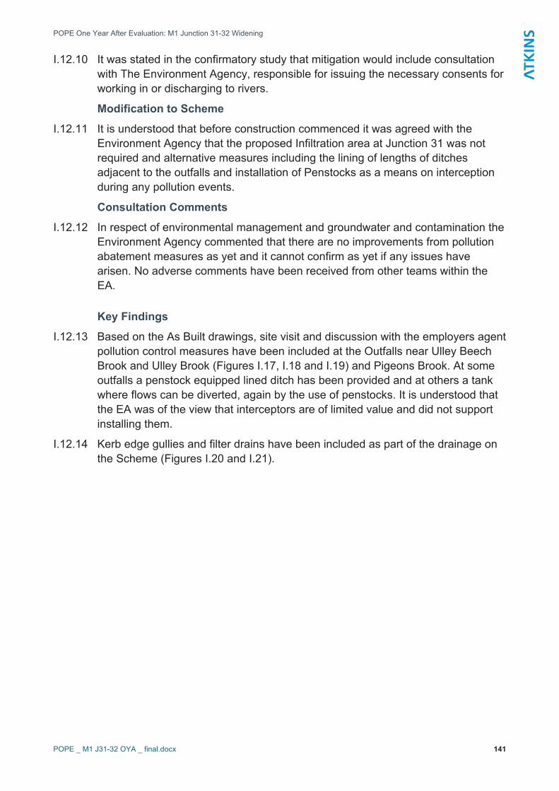
POPE One Year After Evaluation: M1 Junction 31-32 Widening
POPE _ M1 J31-32 OYA _ final.docx 141
I.12.10 It was stated in the confirmatory study that mitigation would include consultation with The Environment Agency, responsible for issuing the necessary consents for working in or discharging to rivers.
Modification to Scheme
I.12.11 It is understood that before construction commenced it was agreed with the Environment Agency that the proposed Infiltration area at Junction 31 was not required and alternative measures including the lining of lengths of ditches adjacent to the outfalls and installation of Penstocks as a means on interception during any pollution events.
Consultation Comments
I.12.12 In respect of environmental management and groundwater and contamination the Environment Agency commented that there are no improvements from pollution abatement measures as yet and it cannot confirm as yet if any issues have arisen. No adverse comments have been received from other teams within the EA.
Key Findings
I.12.13 Based on the As Built drawings, site visit and discussion with the employers agent pollution control measures have been included at the Outfalls near Ulley Beech Brook and Ulley Brook (Figures I.17, I.18 and I.19) and Pigeons Brook. At some outfalls a penstock equipped lined ditch has been provided and at others a tank where flows can be diverted, again by the use of penstocks. It is understood that the EA was of the view that interceptors are of limited value and did not support installing them.
I.12.14 Kerb edge gullies and filter drains have been included as part of the drainage on the Scheme (Figures I.20 and I.21).
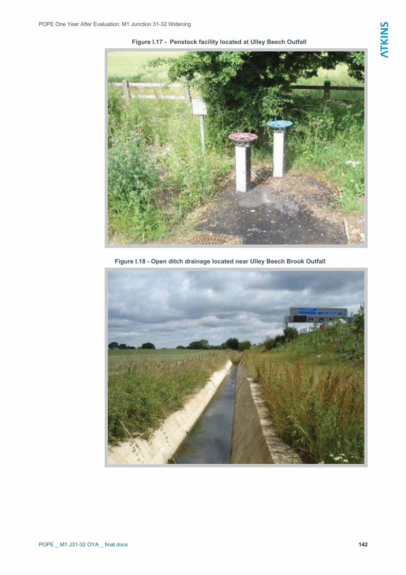
POPE One Year After Evaluation: M1 Junction 31-32 Widening
POPE _ M1 J31-32 OYA _ final.docx 142
Figure I.17 - Penstock facility located at Ulley Beech Outfall
Figure I.18 - Open ditch drainage located near Ulley Beech Brook Outfall
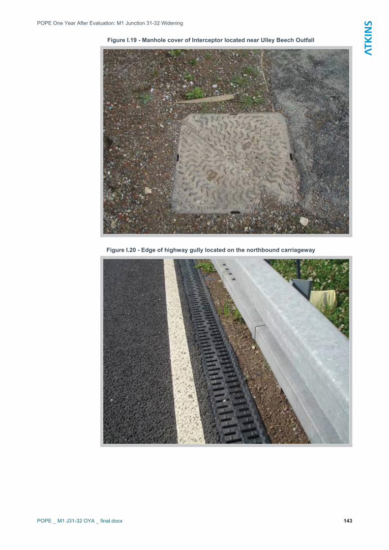
POPE One Year After Evaluation: M1 Junction 31-32 Widening
POPE _ M1 J31-32 OYA _ final.docx 143
Figure I.19 - Manhole cover of Interceptor located near Ulley Beech Outfall
Figure I.20 - Edge of highway gully located on the northbound carriageway
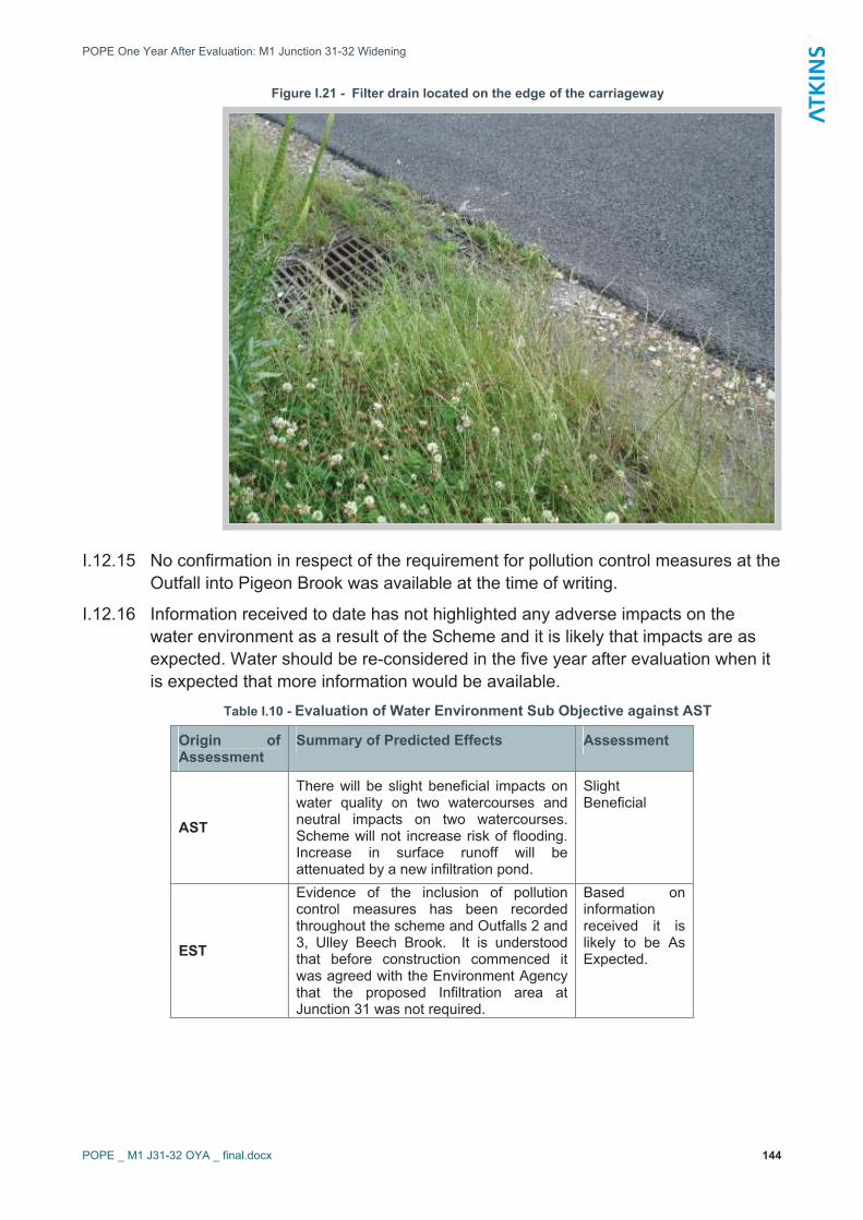
POPE One Year After Evaluation: M1 Junction 31-32 Widening
POPE _ M1 J31-32 OYA _ final.docx 144
Figure I.21 - Filter drain located on the edge of the carriageway
I.12.15 No confirmation in respect of the requirement for pollution control measures at the Outfall into Pigeon Brook was available at the time of writing.
I.12.16 Information received to date has not highlighted any adverse impacts on the water environment as a result of the Scheme and it is likely that impacts are as expected. Water should be re-considered in the five year after evaluation when it is expected that more information would be available.
Table I.10 - Evaluation of Water Environment Sub Objective against AST
Origin of Assessment
Summary of Predicted Effects Assessment
AST
There will be slight beneficial impacts on water quality on two watercourses and neutral impacts on two watercourses. Scheme will not increase risk of flooding. Increase in surface runoff will be attenuated by a new infiltration pond.
SlightBeneficial
EST
Evidence of the inclusion of pollution control measures has been recorded throughout the scheme and Outfalls 2 and 3, Ulley Beech Brook. It is understood that before construction commenced it was agreed with the Environment Agency that the proposed Infiltration area at Junction 31 was not required.
Based on informationreceived it is likely to be As Expected.

POPE One Year After Evaluation: M1 Junction 31-32 Widening
POPE _ M1 J31-32 OYA _ final.docx 145
I.13 Physical Fitness Predicted Impacts
I.13.1 The AST stated ‘not applicable’ under qualitative impacts, with a neutral score overall.
I.13.2 The ES concluded that there would be no alteration to the footpath network, though some inconvenience might occur during construction. The CSR confirmed that there would be no permanent closure of footpaths or bridleways, nor any permanent loss of amenity.
I.13.3 It was assessed that no new severance of pedestrian or equestrian movement would occur as a result of the proposed scheme.
Approved Scheme and Mitigation Measures
I.13.4 The Non–Motorised User (NMU) Crossing Survey prepared in 2002 recommended improvements, comprising of a drop crossing at the junction 31 to accommodate NMUs.
Modification to Scheme
I.13.5 None recorded.
Consultation Comments
I.13.6 No responses in respect of physical fitness are anticipated.
Key Findings
I.13.7 It is understood that no MNU post opening survey has been undertaken on the basis that NMUs are prohibited access to the Motorway. No new surveys of footpaths or bridleways have been carried out for this report. It is considered unlikely that the improvements within the motorway corridor will have had any impact on users of the PROWs.
I.13.8 The existing footpath route that runs along High Lane is very close to the motorway as can be seen in Figure I.22 below, existing hedges have been retained and it is considered that although the new gantries are visible that the visual intrusion has remained similar to before the scheme, as expected
I.13.9 In line with the recommendations of the NMU survey dropped kerbs are present at pedestrian crossing points on the roundabout at Junction 31. It is understood that dropped kerbs were provided prior to the scheme. (Figures I.23 and I.24).

POPE One Year After Evaluation: M1 Junction 31-32 Widening
POPE _ M1 J31-32 OYA _ final.docx 146
Table I.11 - Evaluation of Physical Fitness Sub Objective against AST
Origin of Assessment
Summary of Predicted Effects Assessment
AST Not applicable Neutral
EST
The site visit confirmed that paths have remained open there was no restriction to access along them or additional severance. Dropped kerbs have been provided as recommended.
As Expected
Figure I.22 - View from footpath route (High Lane) looking towards the Motorway (M1) in a south easterly direction

POPE One Year After Evaluation: M1 Junction 31-32 Widening
POPE _ M1 J31-32 OYA _ final.docx 147
Figure I.13 - Dropped kerb at pedestrian crossing point on the roundabout at Junction 31
Figure I.24 - Dropped kerb at pedestrian crossing point on the roundabout at Junction 31

POPE One Year After Evaluation: M1 Junction 31-32 Widening
POPE _ M1 J31-32 OYA _ final.docx 148
I.14 Journey Ambience Predicted Impacts
I.14.1 The AST stated that traveller stress was likely to improve slightly due to more free flowing traffic and fewer delays. Congestion would not increase by the design year. Overall the impact was predicted to be moderate beneficial.
Driver Views
I.14.2 It was commented on within the Landscape Section of the CSR with regards to Journey Ambience, the addition of gantries on the motorway was expected to have an impact on the visual quality of the landscape as viewed by the motorist. It was assessed that there would be no change in the short-term; however, increased planting would limit longer distance views from the motorway in the medium term.
Driver Stress
I.14.3 It was assessed in the Environmental Impact Tables that driver stress was high. In terms of safety it was assessed that there would be no change.
Driver Care
I.14.4 In terms of driver care it was assessed that in terms of driver information that it would be better as a result of the scheme. Driver cleanliness, facilities and environment were considered not applicable.
Approved Scheme and Mitigation Measures
I.14.5 No specific mitigation measure.
Modification to Scheme
I.14.6 None recorded.
Consultation Comments
I.14.7 No responses in respect of journey ambience are anticipated.
Key Findings
Driver Ambience and Traveller Care
I.14.8 It was noted during the site visit that there were several SOS locations along the scheme and dedicated refuge areas for maintenance vehicles, which are located off the hard shoulder when the hard shoulder running is in operation. The SOS communication point is located behind safety barriers in most instances (Figure I.25).
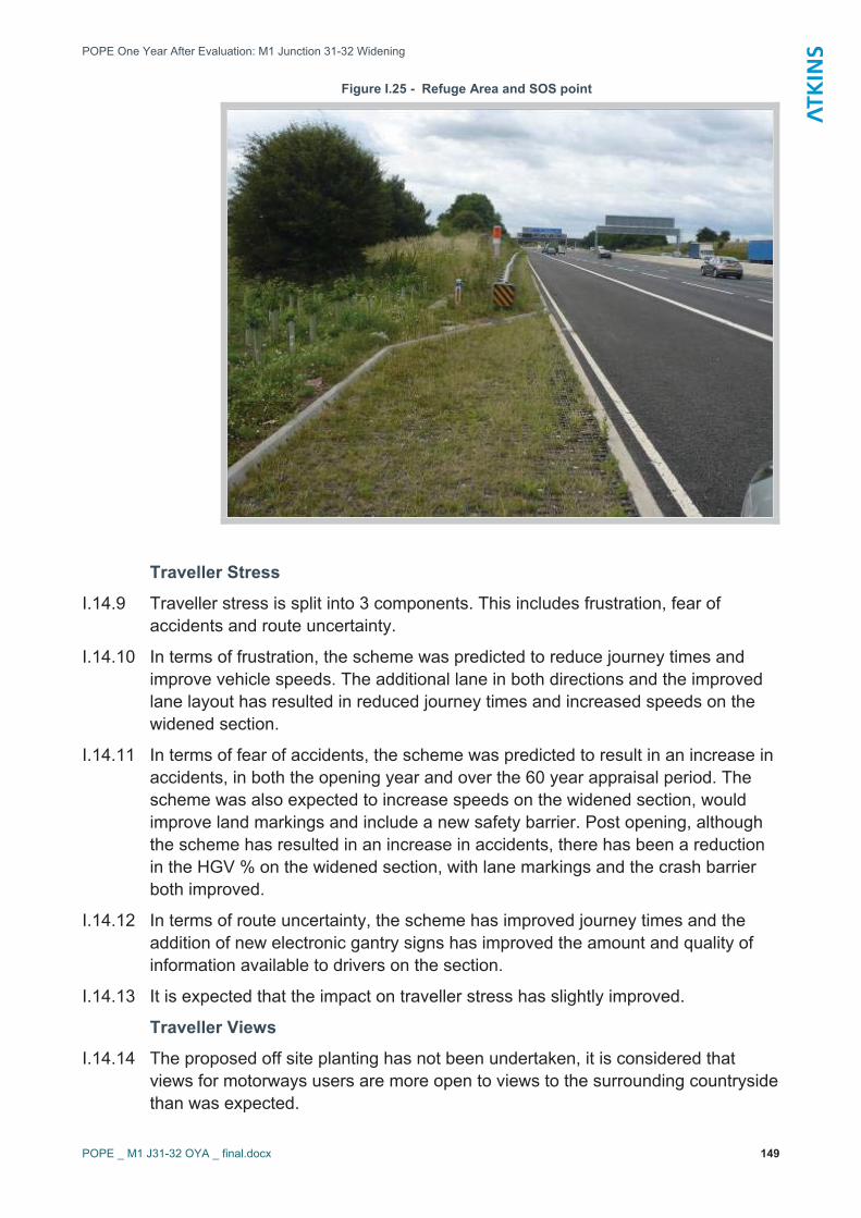
POPE One Year After Evaluation: M1 Junction 31-32 Widening
POPE _ M1 J31-32 OYA _ final.docx 149
Figure I.25 - Refuge Area and SOS point
Traveller Stress
I.14.9 Traveller stress is split into 3 components. This includes frustration, fear of accidents and route uncertainty.
I.14.10 In terms of frustration, the scheme was predicted to reduce journey times and improve vehicle speeds. The additional lane in both directions and the improved lane layout has resulted in reduced journey times and increased speeds on the widened section.
I.14.11 In terms of fear of accidents, the scheme was predicted to result in an increase in accidents, in both the opening year and over the 60 year appraisal period. The scheme was also expected to increase speeds on the widened section, would improve land markings and include a new safety barrier. Post opening, although the scheme has resulted in an increase in accidents, there has been a reduction in the HGV % on the widened section, with lane markings and the crash barrier both improved.
I.14.12 In terms of route uncertainty, the scheme has improved journey times and the addition of new electronic gantry signs has improved the amount and quality of information available to drivers on the section.
I.14.13 It is expected that the impact on traveller stress has slightly improved.
Traveller Views
I.14.14 The proposed off site planting has not been undertaken, it is considered that views for motorways users are more open to views to the surrounding countryside than was expected.

POPE One Year After Evaluation: M1 Junction 31-32 Widening
POPE _ M1 J31-32 OYA _ final.docx 150
I.14.15 It is considered that the effect of the introduction of the gantries on driver views is as expected.
Table I.12 - Evaluation of Journey Ambience Sub Objective against AST
Origin of Assessment
Summary of Predicted Effects Assessment
ASTTraveller stress is likely to improve slightly due to more free flowing traffic and fewer delays. Congestion will not increase by the design year
Moderate Beneficial
EST
The proposed off site planting has not been undertaken allowing more long distance open views for motorway users to the surrounding countryside. The impact on traveller stress has been slight beneficial due to the improved journey times and improved driver information.
As Expected
Table I.13 – Information requested and received
Information Requested Comments
AST AST version dated 17th March 2006
Environmental Statement
The widening scheme was subject to an EIA and was reported in an ES published in 1994. The scheme was put on hold and due to the time lapse, in 2005 the Highways Agency requested that confirmatory studies be undertaken to update the baseline information. The Confirmatory Studies Report (CSR) for the scheme was published in October 2005.
A Tree Windthrow assessment was published in December 2005
As Built drawings for landscape, ecological mitigation measures, drainage, fencing, earthworks etc
It was confirmed by the Employer’s Agent that with the exception of landscape works there was little ‘built’ ecological mitigation work. No drawings were produced. Landscape, drainage, fencing and earthworks ‘as built’ information provided
Construction Environment Management Plan (CEMP)
CEMP provided (including Environmental Action Plan).
Landscape and ecology management plans Not available to date
Contact names for consultation Some provided others sourced by the POPE team
Archaeology reports Informed that no archaeological works required
Properties eligible for noise insulation None
Part 1 Claims The HA Part 1 Claims Team advised that it is too soon in the claims process and information will be made available for the FYA report
Post opening survey or monitoring e.g. for ecology, water quality
Great Crested Newt Monitoring Report Method Statement and 2008 Monitoring Report received.
Animal mortality data Animal mortality data for M1 Junction 31-32 from June 2003 to date received from MAC.

POPE One Year After Evaluation: M1 Junction 31-32 Widening
POPE _ M1 J31-32 OYA _ final.docx 151
Information Requested Comments
Scheme newsletters etc Informed none available.
NMU post construction survey None undertaken as NMU prohibited on the motorway and no impact on the surrounding NMU network.


![[Area] Technology Managing Agent Contractor Contract ...assets.highways.gov.uk/specialist-information/guidance-and-best... · Technology Managing Agent Contractor Contract Service](https://static.fdocuments.in/doc/165x107/5ab7d0d87f8b9a28468c10b8/area-technology-managing-agent-contractor-contract-managing-agent-contractor.jpg)