7 GENERAL DEVELOPMENT STANDARDS
46
7 7-1 GENERAL DEVELOPMENT STANDARDS 7.1 LANDSCAPING AND SCREENING UNIFIED DEVELOPMENT ORDINANCE | Adopted 11.28.2016 7 GENERAL DEVELOPMENT STANDARDS 7.1 LANDSCAPING AND SCREENING The appropriate use of existing and supplemental landscaping provides aesthetic, environmental, and economic benefits and contributes to the overall quality of life in all communities. The purpose of this section is to: • Enhance appearance and increase property values in Lancaster County. • Provide visual buffers and transitions between dissimilar land uses and protect abutting properties from potential negative impacts of neighboring development and to preserve the character and value of a property and provide a sense of privacy. • Improve the visual quality of Lancaster County and minimize the potential impacts of development such as noise, dust, and glare of lights. • Improve the quality and efficacy of stormwater run-off while also providing opportunities for climatic control and reduced electricity costs. • Contribute to the overall quality of life and the built environment in Lancaster County. 7.1.1 TREE PROTECTION AND APPLICABILITY MATRIX The standards contained in this chapter shall apply to the following development conditions: Development Condition Applicability New Construction (Except Single-Family and Two-Family Dwellings on Previously Platted Lots) All standards apply. Expansion of Parking Areas (Less than 50% of Total Existing Area or less than 12 spaces) All standards apply only to the parking lot expansion areas. Expansion of Parking Areas (50% or Greater of Total Existing Area or 12 spaces or more) All new and existing parking areas and non-conforming street frontages per Section 7.1.4 shall be brought into full compliance with this chapter. Building Expansion (Less than 50% of Existing Floor Area) All standards shall apply only to the area around the addition that is parallel to any edge of the expansion area and extending to the property line or street pavement edge. This includes required street trees. (See diagram.) Building Expansion (50% or Greater of Existing Floor Area) The entire site shall be brought into full compliance with this chapter. Change of Use (From Residential to Non-Residential, OR any change of use which requires a more dense buffer yard) The entire site shall be brought into full compliance with this chapter. Change of Use (From Non-Residential to another Non- Residential) The site shall be brought into compliance with Sections 7.1.2 and 7.1.3. Building Interior and/or Exterior Renovation Only Compliance with this chapter is not required.
Transcript of 7 GENERAL DEVELOPMENT STANDARDS

7
7-1
GENERAL DEVELOPMENT STANDARDS 7.1 LANDSCAPING AND SCREENING
UNIFIED DEVELOPMENT ORDINANCE | Adopted 11.28.2016
7 GENERAL DEVELOPMENT STANDARDS
7.1 LANDSCAPING AND SCREENING
The appropriate use of existing and supplemental landscaping provides aesthetic, environmental, and economic benefits and contributes to the overall quality of life in all communities. The purpose of this section is to:
• Enhance appearance and increase property values in Lancaster County.
• Provide visual buffers and transitions between dissimilar land uses and protect abutting properties from potential negative impacts of neighboring development and to preserve the character and value of a property and provide a sense of privacy.
• Improve the visual quality of Lancaster County and minimize the potential impacts of development such as noise, dust, and glare of lights.
• Improve the quality and efficacy of stormwater run-off while also providing opportunities for climatic control and reduced electricity costs.
• Contribute to the overall quality of life and the built environment in Lancaster County.
7.1.1 TREE PROTECTION AND APPLICABILITY MATRIX The standards contained in this chapter shall apply to the following development conditions:
Development Condition Applicability New Construction (Except Single-Family and Two-Family Dwellings on Previously Platted Lots) All standards apply.
Expansion of Parking Areas (Less than 50% of Total Existing Area or less than 12 spaces) All standards apply only to the parking lot expansion areas.
Expansion of Parking Areas (50% or Greater of Total Existing Area or 12 spaces or more)
All new and existing parking areas and non-conforming street frontages per Section 7.1.4 shall be brought into full compliance with this chapter.
Building Expansion (Less than 50% of Existing Floor Area)
All standards shall apply only to the area around the addition that is parallel to any edge of the expansion area and extending to the property line or street pavement edge. This includes required street trees. (See diagram.)
Building Expansion (50% or Greater of Existing Floor Area) The entire site shall be brought into full compliance with this chapter. Change of Use (From Residential to Non-Residential, OR any change of use which requires a more dense buffer yard) The entire site shall be brought into full compliance with this chapter.
Change of Use (From Non-Residential to another Non- Residential)
The site shall be brought into compliance with Sections 7.1.2 and 7.1.3.
Building Interior and/or Exterior Renovation Only Compliance with this chapter is not required.

7
7-2
GENERAL DEVELOPMENT STANDARDS 7.1 LANDSCAPING AND SCREENING
UNIFIED DEVELOPMENT ORDINANCE | Adopted 11.28.2016
A. REQUIRED SITE LANDSCAPING AREAS The diagram below is intended to provide guidance by illustrating the type of landscaping areas and buffer yards required by this chapter. This diagram is not inclusive of the required landscaping and buffer areas for all development applications.
1. Building perimeter landscaping (PB, NB, GB, and RB Districts only) 2. Commercial building (PB, NB, GB, RB Districts) 3. Planting strip (5-foot minimum width) and sidewalk 4. Parking areas 5. Mixed-use buildings (RMX, MX, IMX Districts) 6. Watercourse buffer (not applicable) 7. Required buffer yard 8. Single family detached residential lots (AR, RR, RN, LDR, MDR, UR, RMX Districts)
B. LANDSCAPE PLAN REQUIRED Prior to obtaining a Zoning Permit, an applicant must receive approval of a landscaping plan as per Chapter 9, Administration, that satisfies the requirements of this chapter.
C. REVISIONS TO LANDSCAPE PLAN Revisions due to lack of plant availability may be approved by the Administrator if:
1. There is no reduction in the quantity of plant material.
2. There is no significant change in size or location of plant materials.
3. The new plants are of the same general category (i.e., canopy trees, understory trees, shrubs, groundcover) and have the same general design characteristics (mature height, crown spread) as the materials being replaced.
4. The new plants are appropriate to Lancaster County’s local climatic conditions in terms of seasonal hardiness and ease of maintenance.

7
7-3
GENERAL DEVELOPMENT STANDARDS 7.1 LANDSCAPING AND SCREENING
UNIFIED DEVELOPMENT ORDINANCE | Adopted 11.28.2016
D. GENERAL PROVISIONS 1. Landscaping must be installed, inspected, and approved prior to the issuance of a Certificate
of Occupancy. A Certificate of Occupancy accompanied by a bond as noted in B, below, may be granted to permit installation of required landscaping subsequent to occupancy of the building.
2. If the season or weather conditions prohibit planting, the developer may provide a bond, an irrevocable letter of credit, or other financial surety in an amount equal to 125 percent of the cost of installing the required landscaping to guarantee the completion of the required planting. The financial surety shall be canceled and/or returned upon completion of the required landscaping.
3. The owner of the property where required landscaping is planted shall be responsible for the maintenance and protection of all required plant and screening materials so as to continue their effectiveness. The owner shall replace any required plantings, which die or otherwise fail to satisfy the requirements of this chapter, within 180 calendar days with an equal or similar species and size. When plant material is severely damaged due to unusual weather conditions, disease, fire, or unforeseen natural occurrences, the owner shall have up to 365 calendar days to replant with submittal of a guarantee. Failure to maintain or replace dead, damaged, or diseased material or to repair a broken fence or wall shall constitute a violation.
4. If existing vegetation is to be used in complying with any part of this section, a plan for the protection of this vegetation during construction must be incorporated into the landscape plan and approved by the Administrator.
5. If a wall, fence or berm is used in conjunction with any vegetation to satisfy any requirements of this chapter, all required vegetation shall be placed on the side of the fence or wall of the development site under consideration.
E. ALTERNATIVE COMPLIANCE 1. Landscape plans proposing alternative methods of compliance may be used where
unreasonable or impractical situations would result from application of the specific landscaping requirements in this chapter. Such situations may result from streams, natural rock formations, topography or other physical conditions, or from lot configuration, utility easements, or unusual site conditions.
2. The Administrator may approve an alternate plan which proposes different plant materials or placement, provided that quality, effectiveness, durability, and performance are equivalent to that required by this section.
3. Decisions of the staff regarding alternate methods of compliance may be appealed to the Board of Zoning Appeals in accordance with Chapter 9.
7.1.2 TREE PROTECTION ON PRIVATE PROPERTY The preservation of existing trees or shrubs to satisfy the landscaping requirements of this chapter is expected. New development, through the protection of trees and existing vegetation, should be creative in design and placement of buildings, structures, parking, and other impervious surfaces as to preserve natural features and to complement the existing topography when practical.
A. ESTABLISHMENT OF TREE SAVE AREAS (TSA) Trees survive the stress of construction best when they are left in stands or larger groupings. For that reason, it is encouraged that, wherever possible, development sites should be designed and developed so that Tree Save Areas (TSAs) are designated in a single, contiguous unit.
1. Tree Credit Incentives: Trees preserved in Tree Save Areas may be credited towards compliance with the requirements of this section according to the following calculation: 1

7
7-4
GENERAL DEVELOPMENT STANDARDS 7.1 LANDSCAPING AND SCREENING
UNIFIED DEVELOPMENT ORDINANCE | Adopted 11.28.2016
tree credit per 700 square feet of protected area. The extent of the canopy spread of the tree or trees at the outer edges of the Tree Save Area shall constitute the limits of the Tree Save Area for the purposes of this measurement. Watercourse buffer areas and wetlands are not eligible for the tree credit and the respective amount of parcel area is exempt from the baseline tree coverage requirement.
2. Additional Incentives: The following incentives are offered to encourage tree preservation within TSAs. Individual TSAs may only be counted toward one of the incentives listed below.
3. Tree Save Area Requirements: In order to qualify for the incentives offered in 1 and 2, above, designated Tree Save Areas must conform to the following standards:
a. Minimum Tree Density: The TSA shall contain, as determined by an informal site assessment, a minimum tree density of at least one tree of 2.5" diameter at breast height (DBH) and a minimum of 10' in height per 700 square feet.
b. Tree Species: In order to be established as a designated Tree Save Area, the trees contained in these areas shall primarily be a mixture of healthy and useful canopy deciduous trees.
c. Maintenance and Ownership: When a TSA is established in association with the incentives as listed in this section, it should be designated, where possible, as a dedicated open space, or in a conservation easement.
d. Tree Removal Inside Tree Save Areas: Trees that are in poor health, as determined by the Administrator, may be removed from Tree Save Areas. All tree removal within the TSA must have prior approval by the Administrator pursuant to the provisions of this section. However, in an emergency situation due to storm damage, or to alleviate an imminent hazard to the health, safety, and welfare of the citizens, or to repair property damage, prior approval for tree removal in previously approved designated areas is not required.
e. Dead or Unhealthy Trees
i. No credit will be allowed for any dead tree, any tree in poor health, or any tree subject to grade alterations.
ii. The death or unhealthy state of any tree(s) used for tree credits, within 3 years of establishing the TSA, shall require the property owner to plant new trees equal to the number of credited trees.
iii. If any tree(s) used for preservation credit is improperly protected or determined to be hazardous, the Administrator may require new trees be planted equal to the number of credit trees.
Action Taken Incentive a. Establishment of a Tree Save
Area Along a Street Reduction by up to 50% of required street tree plantings at the rate of 1 less street tree for every 700 square feet of TSA established.
b. Establishment of a Tree Save Area In or Adjacent to a Parking Area
Reduction by up to 50% of required parking lot plantings at the rate of 1 less canopy tree or 2 less understory trees for each 700 square feet of TSA established.
c. Establishment of a Tree Save Area In or Along a R equired Buffer Yard
Reduction by up to 50% of required buffer yard plantings at the rate of 1 less canopy tree or 2 less understory trees for each 700 square feet of TSA established. The remaining buffer yard must still meet the required opacity as established in Section 7.1.5.

7
7-5
GENERAL DEVELOPMENT STANDARDS 7.1 LANDSCAPING AND SCREENING
UNIFIED DEVELOPMENT ORDINANCE | Adopted 11.28.2016
iv. The Administrator may require trees left outside preservations areas to be removed if improperly protected or determined to be hazardous.
7.1.3 STREET TREE AND BUILDING PERIMETER PLANTINGS It is the desire of the County to maintain tree-lined, pedestrian-friendly streets specifically in Mixed-Use Districts and in Transitional and Special Districts. Street trees shade the pedestrian realm of the street, encourage cars to move more slowly, improve pedestrian safety by creating a buffer between the moving cars and the sidewalk, absorb stormwater, absorb pollutants from tailpipe emissions, and add value to the fronting properties.
A. STREET TREE PLANTING REQUIREMENTS Street trees shall be planted in all rights-of-way adjacent to the development, between the street and the sidewalk, in accordance with the table and provisions below:
* Understory Trees may be substituted for Canopy Trees in existing development with planting strips less than 5 feet wide or tree wells less than 25 square feet.
1. Median Trees: Whenever a boulevard street type is constructed, the developer or applicant shall also install trees in the boulevard median at the rate of 1 canopy tree for every 50 linear feet of road median. understory trees may be substituted for canopy trees in medians less than 10 feet wide. The maximum spacing between trees shall be 50 feet on-center.
2. Existing County-Adopted Streetscape/Tree Planting Plan: Where a County-approved existing tree pattern exists on a street, the placement of new trees shall be compatible with the established pattern/species.
3. Private Drives for Commercial Development: Private drives, including vehicular ways between parking areas and building frontages, which serve commercial lots shall meet the street tree planting requirements within this chapter.
4. Residential Driveway/Alley: Landscaping is not required along any residential driveway or alley.
B. STREET TREE SPECIFICATIONS 1. Where street trees are required, such trees shall be within the right-of-way and be planted in
a planting strip between the sidewalk and the traveled way or in tree wells located along the street/sidewalk, except where the Administrator determines this impossible due to insufficient right-of-way, topography, utility conflicts, or conflicts with South Carolina Department of Transportation (SCDOT) operated roads. Where the Administrator
District Requirement AR, RR, RN, OSP Districts Not required
MH, LDR, MDR, HDR, UR, RMX Districts
Rate: 1 Canopy Tree for every 40 feet of street frontage Spacing: Maximum of 50 feet on-center Location: In Planting Strip (5-foot minimum width)*
MX, IMX, PB, NB, GB, RB, INS, LI, HI, M Districts
Rate: 1 Canopy Tree for every 50 feet of street frontage Spacing: Maximum of 50 feet on-center Location: In Planting Strip (5-foot minimum width)* or Tree Well (25-square-foot minimum area)
MX, IMX, NB, GB Districts with On-Street Parking and Ground Floor Retail
Rate: 1 Canopy Tree for every 40 feet of street frontage Spacing: Maximum of 50 feet on-center Location: Tree Well (25-square-foot minimum area)*
Existing Development with Non-Conforming Frontages See Section 7.1.1*

7
7-6
GENERAL DEVELOPMENT STANDARDS 7.1 LANDSCAPING AND SCREENING
UNIFIED DEVELOPMENT ORDINANCE | Adopted 11.28.2016
determines that it is impractical for street trees to be located within the right of way, compliance with this section may be achieved by planting street trees on private property.
2. Tree wells shall provide a root aeration zone around the base of a tree. If the adjacent sidewalk is less than 6 feet in width, tree grates shall be provided to cover the exposed area of soil and to widen the pedestrian passage zone along the sidewalk.
3. Street trees must (unless approved by the Administrator) maintain the same species, spacing, and distance from the street along both sides of the street.
4. The Administrator may approve the use of understory trees instead of canopy trees where such trees satisfy SCDOT requirements along State-owned roads.
C. BUILDING PERIMETER LANDSCAPING 1. Applicability: The following provisions for building perimeter landscaping shall apply to
the PB, NB, GB, and RB Districts.
2. Minimum Required Landscape Area: A minimum 6 foot wide area shall be provided for landscaping along any side of the building facing a public right-of-way. Up to 25 percent of the building width along the street may be utilized for entrance walkways.
3. Minimum Required Landscaping: The minimum required landscaping shall consist of one of the following options every 40 linear feet:
a. 2 understory trees; or
b. 10 shrubs; or
c. Any equivalent combination thereof.
This 40 foot requirement shall only serve as a ratio for establishing the minimum required landscaping. In locating the minimum required landscaping care shall be taken to ensure that adequate space is provided for the width of tree spread, height, and root system requirements.
7.1.4 PARKING LOT AREA LANDSCAPING A. REQUIRED PARKING LOT LANDSCAPE AREAS
The diagram below is intended to provide guidance by illustrating the screening and landscape islands required by this chapter. This diagram is not inclusive of the required screening and landscaping islands for all new or expanded parking lots.

7
7-7
GENERAL DEVELOPMENT STANDARDS 7.1 LANDSCAPING AND SCREENING
UNIFIED DEVELOPMENT ORDINANCE | Adopted 11.28.2016
1. Private drive islands 2. Parking lot islands/planting areas 3. Parking lot perimeter screening area
B. EXEMPTIONS Parking lots which serve industrial and automotive uses, as designated in the Use Table in Section 2.5.3, (whether for display of new or used vehicles for rental/sales/lease or for employee or customer parking) shall be exempt from the parking area landscaping and curbing requirements of Section 2.5.3 if a 50 foot wide landscape area with a semi-opaque screen is provided around any portion of the lot adjacent to another property or a public or private street.
C. PARKING LOT PERIMETER SCREENING 1. Applicability: The following provisions for parking lot perimeter screening shall
apply to all parking lots containing more than 10 spaces.
2. Required Screen Along Streets: Parking lots shall be screened from sidewalks and streets (public and private) by a semi-opaque screen to an average height of 3 feet, along with canopy trees planted with a maximum spacing of 40 feet on-center, for screening of car lights and glare.
a. Effective screening devices may include decorative brick walls, wood fences, earth berms, architectural features (e.g., facade extension, pergolas) and tight evergreen hedges which shall reach the required height within two years of planting, or any combination of the above.
b. The height of the screen, except for trees, shall not exceed 4 feet at any time.

7
7-8
GENERAL DEVELOPMENT STANDARDS 7.1 LANDSCAPING AND SCREENING
UNIFIED DEVELOPMENT ORDINANCE | Adopted 11.28.2016
c. Optional 8-foot openings shall be allowed every 50 feet to permit pedestrian passage where a formal connection to a sidewalk or pathway is provided. Openings for permitted driveways and their associated sight triangles are also permitted.
3. Required Screen Along Adjacent Properties: Parking lots shall be screened from adjacent properties by canopy trees planted with a maximum spacing of 40 feet on-center. Trees planted adjacent to parking lots to satisfy the buffer yard requirements in Section 7.1.5 may count toward this requirement.
4. Minimum Width Reserved for Perimeter Screens: 10 feet
D. PARKING LOT INTERIOR LANDSCAPING 1. Applicability: The following provisions for parking lot interior landscaping shall apply to
all parking lots containing more than 10 spaces.
2. Parking Lot Islands/Planting Areas
a. The minimum number of trees shall be 1 canopy tree per 10 parking spaces. Two understory trees may be used to replace 1 canopy tree for no more than 1/3 of the required canopy trees.
b. All trees and plantings shall be in planting areas or landscape islands, protected by curbs or wheel stops, with a minimum area of 180 square feet and a minimum width of 10 feet.
c. Parking lot islands or planting areas with a minimum of 1 canopy tree or 2 understory trees shall be placed at the end of every row of parking.
d. No parking space shall be more than 50 feet from the base of a tree. Parking lots fully designed using bioretention areas, as outlined in Section 7.1.4.F below, are exempt from this requirement.
3. Private Drive Islands: All private drives that channel traffic within the parking area, including vehicular ways between parking areas and building frontages, shall be separated from adjacent sidewalks or rows of parking by a landscaped area with a minimum width of 6 feet, containing canopy trees planted at a maximum spacing of 40 feet on-center. Understory trees may be substituted for canopy trees at the rate of 2 understory trees for every required canopy tree for up to 1/3 of the total required canopy trees. Traffic control islands required by SCDOT may be raised concrete or striped.
4. Pedestrian Access: Sidewalks or paths may be provided within required landscaped areas to address pedestrian needs.

7
7-9
GENERAL DEVELOPMENT STANDARDS 7.1 LANDSCAPING AND SCREENING
UNIFIED DEVELOPMENT ORDINANCE | Adopted 11.28.2016
.
E. CURBING All parking areas and landscaped islands shall either be curbed using a vertical curb or wheel stops. Curbing may be discontinuous or perforated allowing stormwater to enter landscaped areas constructed for bioretention (rain gardens). Where bioretention areas are constructed, wheel stops may be used in place of curbing. Where landscaping is above grade, curbing must be continuous to prevent landscaping material from eroding into the parking area.
Discontinuous curbing or wheel stops are permitted to allow stormwater infiltration in bioretention areas.
F. BIORETENTION AREAS/RAIN GARDENS
1. Rain Gardens Permitted: Required parking lot landscaping may be incorporated with one or more consolidated bioretention areas (rain gardens). Bioretention areas shall be located where it is most practical to capture stormwater, manage parking lot traffic, and facilitate pedestrian use, including adjacent to and connecting with vegetated areas on the perimeter of a parking lot. Bioretention areas shall be designed and landscaped to trap and mitigate runoff from paved surfaces consistent with the description and intent of the South Carolina Department of Health and Environmental Control: Stormwater Best Management Practices Manual.
2. Parking Dimension Bonus: A portion of the space devoted to motor vehicle parking may be landscaped instead of paved, as follows:
a. A landscaped area may include up to 3 feet of the front of the parking space as measured from a line parallel to the direction of the bumper of a vehicle. The landscape strip shall be a minimum of 6 feet in width.
b. The landscaped area within the parking space counts toward parking lot landscaping requirements and toward any overall site landscaping requirements.
c. In order to utilize this parking dimension bonus, landscaping must be below grade and designed as a bio-retention area.
Required parking landscaped areas may include up to 3 feet of the front of a parking space as measured from a line parallel to the direction of the bumper of a vehicle using the space, as shown.

7
7-10
GENERAL DEVELOPMENT STANDARDS 7.1 LANDSCAPING AND SCREENING
UNIFIED DEVELOPMENT ORDINANCE | Adopted 11.28.2016
G. ADDITIONAL STANDARDS FOR LARGE PARKING LOTS (GREATER THAN 100 SPACES) Pedestrian Walkways: For every 4 traffic aisles in parking bays, a landscape island between 2 back-to-back parking bays with a pedestrian walkway shall be provided and shall extend the entire length of the parking bay or aisle. The width of such landscape island shall be a minimum of 15 feet, measured from the back of curb to back of curb, and the width of the pedestrian walkway shall be a minimum of 5 feet. Trees shall be planted along the pedestrian walkway at the rate of 1 canopy tree or 2 understory trees for every 50 linear feet. Crosswalks shall be provided across private drives/driveways from these pedestrian islands to connect to any adjacent building entrances, private walkways, and public sidewalks along the street frontage.
7.1.5 BUFFERS AND SCREENING
Buffer yards are planting areas designed to separate incompatible adjacent uses and provide privacy and protection against potential adverse impacts of an adjoining incompatible use or zoning district.
10 space maximum between interior landscape islands
Interior landscape islands minimum of 1 canopy tree or 2 understory trees
Minimum of 1 landscape island with pedestrian corridor per 4 parking aisles
7
7-11
GENERAL DEVELOPMENT STANDARDS 7.1 LANDSCAPING AND SCREENING
UNIFIED DEVELOPMENT ORDINANCE | Adopted 11.28.2016
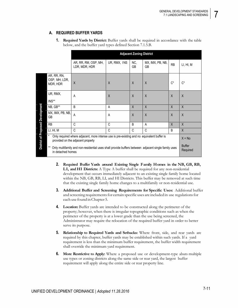
A. REQUIRED BUFFER YARDS 1. Required Yards by District: Buffer yards shall be required in accordance with the table
below, and the buffer yard types defined Section 7.1.5.B.
2. Required Buffer Yards around Existing Single Family Homes in the NB, GB, RB, L I, and HI Districts: A Type A buffer shall be required for any non-residential development that occurs immediately adjacent to an existing single family home located within the NB, GB, RB, LI, and HI Districts. This buffer may be removed at such time that the existing single family home changes to a multifamily or non-residential use.
3. Additional Buffer and Screening Requirements for Specific Uses: Additional buffer and screening requirements for certain specific uses are included in use regulations for each use found in Chapter 5.
4. Location: Buffer yards are intended to be constructed along the perimeter of the property; however, when there is irregular topographic conditions such as when the perimeter of the property is at a lower grade than the use being screened, the Administrator may require the relocation of the required buffer yard in order to better serve its purpose.
5. Relationship to Required Yards and Setbacks: Where front, side, and rear yards are required by this chapter, buffer yards may be established within such yards. If a yard requirement is less than the minimum buffer requirement, the buffer width requirement shall override the minimum yard requirement.
6. More Restrictive to Apply: Where a proposed use or development-type abuts multiple use types or zoning districts along the same side or rear yard, the largest buffer requirement will apply along the entire side or rear property line.
Adjacent Zoning District
AR, RR, RM, OSP, MH, LDR, MDR, HDR
UR, RMX, I NS NC, GB
MX, IMX, PB, NB, GB RB LI, HI, M
Dist
rict o
f Pro
pose
d De
velo
pmen
t
AR, RR, RN, OSP, MH, LDR, MDR, HDR
X
X
X
X
C*
C*
UR, RMX,
INS** A X X X X X
NB, GB** B A X X X X MX, IMX, PB, NB, GB A A X X X X
RB C C B A X X LI, HI, M C C C C B X * Only required where adjacent, more intense use is pre-existing and no equivalent buffer is
provided on the adjacent property
** Only multifamily and non-residential uses shall provide buffers between adjacent single family uses in detached homes
X = No
Buffer Required

7
7-12
GENERAL DEVELOPMENT STANDARDS 7.1 LANDSCAPING AND SCREENING
UNIFIED DEVELOPMENT ORDINANCE | Adopted 11.28.2016
7. Buffer Location Restrictions: Buffers shall not be located on any portion of any existing or proposed street right-of-way or utility easement (unless permitted by the easement holder).
B. BUFFER YARD TYPES 1. Type A Buffer Yard: A Type A buffer yard is a planting strip intended to separate uses,
provide vegetation in densely developed areas, and enhance the appearance of individual properties.
2. Type B Buffer Yard: A Type B buffer yard is a medium density screen which is intended to create a visual separation between uses and zoning districts.
Type A Buffer Yard Options Minimum
Depth Minimum Plantings per 100 linear feet
Wall, Fence, or Berm
Required Opacity
Option 1 20 feet 1 Canopy Tree
2 Understory Trees
8 Evergreen Shrubs
Not Required Semi-opaque (i.e., having only seasonal horizontal openings not exceeding 25% of the total width
from the ground to a height of 6 feet within 2 years of planting)
Option 2 10 feet 2 Canopy Trees
2 Understory Trees
12 Evergreen Shrubs
Not Required
Type B Buffer Yard Options Minimum
Depth Minimum Plantings per 100 linear feet
Wall, Fence, or Berm
Required Opacity
Option 1 20 feet 2 Evergreen Trees
1 Canopy Tree
2 Understory Trees
12 Evergreen Shrubs
Not Required Semi-opaque (i.e., having only seasonal horizontal openings not exceeding 10% of the total width
from the ground to a height of 8 feet within 2 years of planting)
Option 2 10 feet 1 Evergreen Tree
1 Canopy Tree
3 Understory Trees
24 Evergreen Shrubs
Not Required

7
7-13
GENERAL DEVELOPMENT STANDARDS 7.1 LANDSCAPING AND SCREENING
UNIFIED DEVELOPMENT ORDINANCE | Adopted 11.28.2016
3. Type C Buffer Yard: A Type C buffer yard is intended to provide a very dense all-season sight barrier to significantly separate uses and zoning districts. It is intended to reduce intrusive lighting and noise from adjacent properties.
C. BUFFER DETAILS 1. Fences and Walls: Any required 6-foot-tall privacy fence or wall shall be made of any
combination of treated and stained wood, brick, stone, wrought iron, polymer, decorative face block, or other composite material as approved by the Administrator and maintained in a like-new manner with the finished side facing towards the zone to be buffered (protected). The material(s) used shall provide an opaque fence. All required vegetation shall be placed on the unfinished side of the fence or wall. A chain link fence with slats is not considered a solid fence for purposes of this section.
2. Berms: All berms, if provided, shall not exceed a slope with maximum rise of 1 foot to a run of 2 feet (a ratio of 1:2) and a maximum height of 4 feet with a compacted flat top of at least 15 inches wide. All berms, regardless of size, shall be stabilized with a ground cover or other suitable vegetation or permanent slope retention device. A combination of trees and shrubs are to be installed in an appropriate design scheme along the berm for appearance, durability, and maintenance as approved by the Administrator. Berms taller than 4 feet shall be approved by the Administrator on a case-by-case basis.
3. Existing Vegetation, Fences, Walls, and Berms: Existing vegetation berms, walls, or fences within the landscaped area, but not including chain link fencing, may be used to fulfill the standards for the type of landscaping required provided that these elements are in good condition as determined by the Administrator. Where existing vegetative areas are to be credited, they shall be shown on the plan with a certification by a licensed landscape architect that the existing vegetation fully complies with the landscape requirements.
4. Riparian Buffer: Any required riparian buffer may be used to satisfy other buffer requirements, provided the plants are equivalent in number and type required by the landscape ordinance. Additional plant materials shall be installed in the riparian buffer to satisfy any remaining plant requirements. Additional plantings shall meet best management practices as determined by the Administrator.
Type C Buffer Yard Options
Minimum Depth
Minimum Plantings per 100 linear feet
Wall, Fence, or Berm
Required Opacity Option 1 40 feet 4 Evergreen Trees
4 Canopy Trees
4 Understory Trees
36 Evergreen Shrubs
Not Required
Completely opaque (i.e., having no horizontal openings from the ground to a height of 8 feet within 2 years of planting)
Option 2 25 feet 4 Evergreen Trees
4 Canopy Trees
4 Understory Trees
Wall or Fence
Option 3 10 feet 2 Evergreen Trees
2 Canopy Trees
2 Understory Trees
12 Evergreen Shrubs
Berm
7
7-14
GENERAL DEVELOPMENT STANDARDS 7.1 LANDSCAPING AND SCREENING
UNIFIED DEVELOPMENT ORDINANCE | Adopted 11.28.2016
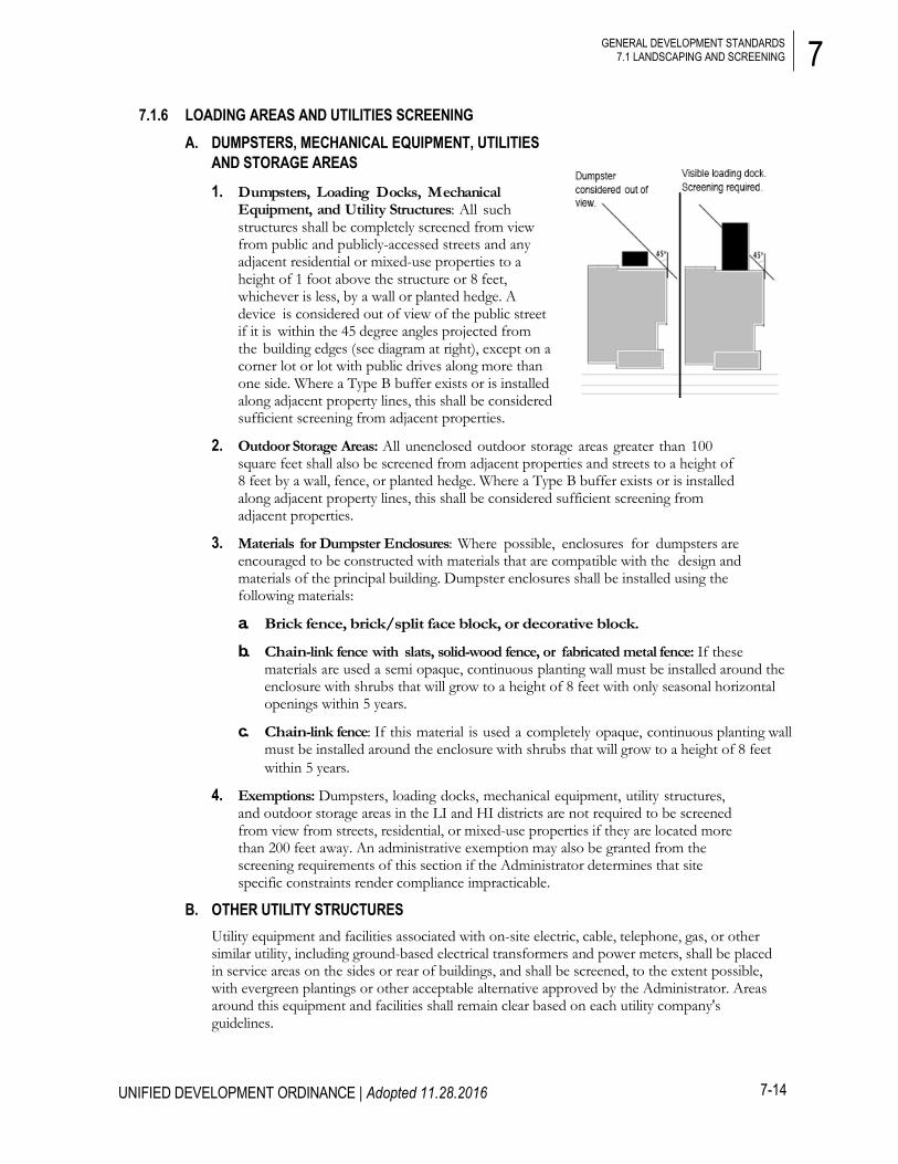
7.1.6 LOADING AREAS AND UTILITIES SCREENING A. DUMPSTERS, MECHANICAL EQUIPMENT, UTILITIES
AND STORAGE AREAS
1. Dumpsters, Loading Docks, Mechanical Equipment, and Utility Structures: All such structures shall be completely screened from view from public and publicly-accessed streets and any adjacent residential or mixed-use properties to a height of 1 foot above the structure or 8 feet, whichever is less, by a wall or planted hedge. A device is considered out of view of the public street if it is within the 45 degree angles projected from the building edges (see diagram at right), except on a corner lot or lot with public drives along more than one side. Where a Type B buffer exists or is installed along adjacent property lines, this shall be considered sufficient screening from adjacent properties.
2. Outdoor Storage Areas: All unenclosed outdoor storage areas greater than 100 square feet shall also be screened from adjacent properties and streets to a height of 8 feet by a wall, fence, or planted hedge. Where a Type B buffer exists or is installed along adjacent property lines, this shall be considered sufficient screening from adjacent properties.
3. Materials for Dumpster Enclosures: Where possible, enclosures for dumpsters are encouraged to be constructed with materials that are compatible with the design and materials of the principal building. Dumpster enclosures shall be installed using the following materials:
a. Brick fence, brick/split face block, or decorative block.
b. Chain-link fence with slats, solid-wood fence, or fabricated metal fence: If these materials are used a semi opaque, continuous planting wall must be installed around the enclosure with shrubs that will grow to a height of 8 feet with only seasonal horizontal openings within 5 years.
c. Chain-link fence: If this material is used a completely opaque, continuous planting wall must be installed around the enclosure with shrubs that will grow to a height of 8 feet within 5 years.
4. Exemptions: Dumpsters, loading docks, mechanical equipment, utility structures, and outdoor storage areas in the LI and HI districts are not required to be screened from view from streets, residential, or mixed-use properties if they are located more than 200 feet away. An administrative exemption may also be granted from the screening requirements of this section if the Administrator determines that site specific constraints render compliance impracticable.
B. OTHER UTILITY STRUCTURES Utility equipment and facilities associated with on-site electric, cable, telephone, gas, or other similar utility, including ground-based electrical transformers and power meters, shall be placed in service areas on the sides or rear of buildings, and shall be screened, to the extent possible, with evergreen plantings or other acceptable alternative approved by the Administrator. Areas around this equipment and facilities shall remain clear based on each utility company's guidelines.

7
7-15
GENERAL DEVELOPMENT STANDARDS 7.1 LANDSCAPING AND SCREENING
UNIFIED DEVELOPMENT ORDINANCE | Adopted 11.28.2016
7.1.7 GENERAL INSTALLATION AND MAINTENANCE STANDARDS A. LANDSCAPE PLAN SUBMITTAL REQUIREMENTS
When a development application is made on any land where the landscaping requirements of this chapter are applicable, such site/subdivision plan application shall be accompanied by a landscape plan as outlined in the Submittal Checklist in Appendix C, Manual of Specifications, Standards, and Design (MSSD).
B. PLANT MATERIAL SPECIFICATIONS 1. Canopy (Large Shade) Trees: All required
canopy trees must be a native or locally-adapted species with an expected mature height of 35 feet or greater and an expected mature crown spread of 30 feet or greater. When planted, canopy trees must be a minimum of 8 feet high, and have a minimum caliper of 2.5 inches as measured at breast height (or approximately 4.5 feet above grade – DBH). Multi-stemmed trees shall have at least 3 stalks (minimum 1-inch DBH) and be at least 8 feet in height when planted.
2. Evergreen Trees: All required evergreen trees must be a native or locally-adapted species with green foliage that lasts through all seasons and an expected mature height of 20 feet or greater. Evergreen trees shall be a minimum of 8 feet in height and have a 2.5-inch DBH when planted.
3. Understory (Small) Trees: All required understory trees must be a minimum of 6 feet high and 2-inch DBH when planted. When mature, understory trees shall be between 15 and 30 feet in height.
4. Shrubs: Shrubs planted as part of a required buffer yard, shall meet the following specifications:
a. Deciduous Shrubs: All deciduous shrubs shall be a minimum of 18 inches in height when planted and shall reach a height of 30 inches and a minimum spread of 30 inches within 2 years of planting.
b. Evergreen Shrubs: All evergreen shrubs shall be a minimum of 30 inches in height when planted and shall reach a height of 48 inches and a minimum spread of 36 inches within 2 years of planting.

7
7-16
GENERAL DEVELOPMENT STANDARDS 7.1 LANDSCAPING AND SCREENING
UNIFIED DEVELOPMENT ORDINANCE | Adopted 11.28.2016
5. Groundcover: All required groundcover plants must be a minimum of 1.5 to 2.5-inch pots with a 4-inch minimum length when planted. Groundcover must be planted with on-center spacing equivalent to the average mature spread for each particular species.
C. PLANT STANDARDS 1. General Material Standards: All plant materials shall be installed in accordance
with the standards found in the latest edition of American Standards for Nursery Stock published by the American Association of Nurserymen. After installation, plant materials shall be mulched with a 3-inch layer of appropriate material.
2. Recommended Species List: Plant materials utilized in meeting the requirements set forth in this section may be chosen from the Lancaster County recommended trees and shrubs list located in Section 4.3.2.J.6.vii. The use of drought-tolerant vegetation that is native to the area is encouraged to reduce dependency upon irrigation.
D. GENERAL CONSTRUCTION STANDARDS 1. Easements & Right-of-Ways: Nothing shall be planted or installed within an
underground or overhead utility easement or a drainage easement without the consent of the Administrator and the easement holder at the time of site plan approval.
2. Grading and Development in Required Landscape Areas: The required landscaping shall not contain any development, impervious surfaces, or site features that do not function to meet these standards or that require removal of existing significant vegetation. If grading within a planting yard is proposed, slopes of 3:1 or less are encouraged to ensure the proper transition of grades to the adjacent property and to facilitate landscaping and maintenance.
3. No Bare Soil Permitted: All portions of the landscaping area not planted with shrubs and trees or covered by a wall or other screening device shall be planted with ground cover and/or grass or covered with natural mulch with a minimum depth of 3 inches.
4. Overhead Power Lines: Where overhead power lines are present, small trees (approximately 20 feet in height at maturity) must be utilized. One small maturing tree is required for every 35 feet of property abutting a street. (Utility lines such as cable and phone do not constitute a hazard, and large maturing trees should be used if only these are present.)
5. Sight Distance: All plant materials within the sight distance triangle at an intersection, or driveway access point as defined in Chapter 6 shall comply with Section 6.14.1.D – J. (Exception: SCDOT has separate provisions for state-maintained roadways.)

7
7-17
GENERAL DEVELOPMENT STANDARDS 7.1 LANDSCAPING AND SCREENING
UNIFIED DEVELOPMENT ORDINANCE | Adopted 11.28.2016
E. PROTECTION OF EXISTING TREES DURING CONSTRUCTION
1. Protective barricades shall be placed around all trees designated to be saved, prior to the start of development activities or grading. Protective barricades shall remain in place until development activities are completed. The following conditions are required:
a. Barricades may consist of 2 x 4 inch posts with 1 x 4 inch rails, orange safety fence, or a similar treatment and shall remain in place until development activities are complete.
b. Signs indicating that the barricade is protecting a tree save area within which construction traffic and storage of materials are not permitted shall be placed at a rate of 1 sign for every 100 linear feet of barricade.
c. The barricaded area shall remain free of all building materials, stockpiled soil, or other construction debris.
d. Construction traffic, storage of vehicles and materials, and grading shall not take place within the protective areas of the existing trees.
2. Barricades shall be erected at a recommended minimum distance from the base of protected trees according to the following standards:
a. For trees 10 inches or less DBH: Place at a minimum distance of 6 feet from the base of each protected tree or outside the dripline, whichever is greater.
b. For trees between 10 and 20 inches DBH: Place at a minimum distance equal to 1.5 feet for each 1 inch in caliper or outside the dripline, whichever is greater.
c. For trees of 20 inches or greater DBH: Place at a minimum distance of 30 feet from the base of each protected tree or outside the dripline, whichever is greater.

7
7-18
UNIFIED DEVELOPMENT ORDINANCE | Adopted 11.28.2016
GENERAL DEVELOPMENT STANDARDS 7.2 PARKING AND DRIVEWAYS
3. Land disturbance within a tree dripline is prohibited except for driveway access points, sidewalks, curb, and gutter.
4. Where grading within a tree dripline cannot be avoided, cut and fill shall be limited to 25 percent of the area within the dripline, and tree roots must be pruned with clean cuts at the edge of the disturbed area. (No fill shall be placed within the dripline of a tree without venting to allow air and water to reach the roots.)
F. INSPECTION The Administrator may inspect the site after the issuance of a Certificate of Occupancy in order to ensure compliance with the approved site plan and to ensure that the landscape is properly maintained. The Administrator may issue a Notice of Violation to comply with the provisions of this ordinance if warranted upon an inspection under the provisions of Chapter 9 of this ordinance.
G. REPLACEMENT OF DISTURBED AND DAMAGED VEGETATION Without prior approval, the disturbance of any required landscaped area or vegetation required by this ordinance shall constitute a violation. All disturbed landscaped areas and vegetation shall be replanted to meet the standards of this section, the stormwater regulations in Chapter 8, and the approved site or sketch plan (landscape plan).
7.2 PARKING AND DRIVEWAYS
7.2.1 PURPOSE AND INTENT Parking lots and similar facilities are necessary elements in the built environment. However, these facilities can cause negative impacts including increased stormwater volume, velocity, and pollutants; increased surface level heat and glare; reduction in the efficiency of the connecting street system; reduction in the operations of the surrounding pedestrian and bicycle network; and interruption of a vibrant and attractive streetscape character. For these reasons, it is the intent of this chapter to impose regulations that mitigate the negative effects of parking lots in Lancaster County, preserve the character of the community, and protect the health, safety, and general welfare of Lancaster County’s residents.
7.2.2 APPLICABILITY The provisions of this chapter shall apply to all new and expanded development, as well as any changes in use that result in an increase in the minimum amount of required parking of at least 5 spaces or 10 percent of the existing spaces, whichever is greater.
7.2.3 PERMITTED PARKING LOCATIONS The following table details the permitted parking locations for each district according to the building types detailed in Chapter 3 of this ordinance. Additional locational requirements may apply to parking areas for specific uses. Such requirements are outlined in Chapter 5, Use Regulations.

7
7-19
UNIFIED DEVELOPMENT ORDINANCE | Adopted 11.28.2016
GENERAL DEVELOPMENT STANDARDS 7.2 PARKING AND DRIVEWAYS
Civic
Detac
hed H
ouse
Town
hous
e
Apar
tmen
t
Gene
ral
Mixe
d-Us
e
Indus
trial
All O
ther B
ldgs
Rura
l
AR U U n/a n/a n/a n/a n/a U
Permitted Parking Configurations
(Also see diagrams on next page)
Location A – Parking permitted in 3rd Layer only
Location B – Parking permitted in 2nd and 3rd Layers only
Location C – Parking permitted in 2nd and 3rd Layers. Parking in 1st Layer restricted to one drive aisle with two bays.
U – Unrestricted
RR U U n/a n/a n/a n/a n/a U RN U n/a n/a n/a n/a n/a n/a U RUB U n/a n/a n/a n/a n/a n/a U MH U U n/a n/a n/a n/a n/a U
Spe
cial
Tra
nsiti
onal
LDR U U – – – – – – MDR U U – – – – – – HDR C U – – – – – – PB U – A A A - – – NB U – B B C - – – GB U – B B U U – – RB U – B B U U – – INS B U B B B B – – OSP - - - - - - - - LI U – – – U U U U HI U – – – U U U U M U – – – U U U U
Neig
hbor
hood
UR C U B B – B – –
RMX B U B B C B – – MX B – B B B B – – IMX B – B B B B B –

7
7-20
UNIFIED DEVELOPMENT ORDINANCE | Adopted 11.28.2016
GENERAL DEVELOPMENT STANDARDS 7.2 PARKING AND DRIVEWAYS
PERMITTED PARKING CONFIGURATION DIAGRAMS Location A
Parking permitted in 3rd Layer only
1st Layer – distance from right-of-way to front of building
2nd Layer – 20 feet
3rd Layer – remainder of lot
Location B
Parking permitted in 2nd and 3rd Layers only
1st Layer – distance from right-of-way to front of building
2nd Layer – 20 feet
3rd Layer – remainder of lot
Location C
Parking permitted in 2nd and 3rd Layers. Parking in 1st Layer restricted to one drive aisle with two bays.
1st Layer – distance from right-of-way to front of building
2nd Layer – 20 feet
3rd Layer – remainder of lot U – Unrestricted
Parking permitted in all layers
1st Layer – distance from right-of-way to front of building
2nd Layer – 20 feet
3rd Layer – remainder of lot
7
7-21
UNIFIED DEVELOPMENT ORDINANCE | Adopted 11.28.2016
GENERAL DEVELOPMENT STANDARDS 7.2 PARKING AND DRIVEWAYS
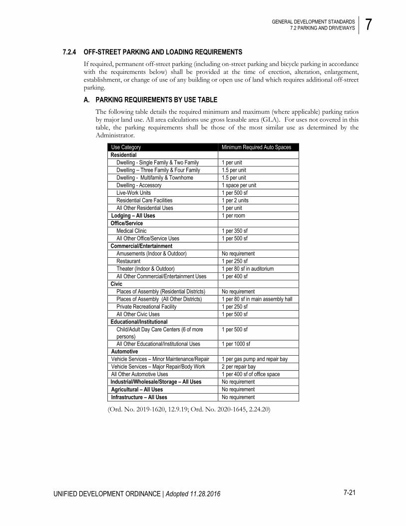
7.2.4 OFF-STREET PARKING AND LOADING REQUIREMENTS If required, permanent off-street parking (including on-street parking and bicycle parking in accordance with the requirements below) shall be provided at the time of erection, alteration, enlargement, establishment, or change of use of any building or open use of land which requires additional off-street parking.
A. PARKING REQUIREMENTS BY USE TABLE The following table details the required minimum and maximum (where applicable) parking ratios by major land use. All area calculations use gross leasable area (GLA). For uses not covered in this table, the parking requirements shall be those of the most similar use as determined by the Administrator.
Use Category Minimum Required Auto Spaces Residential
Dwelling - Single Family & Two Family 1 per unit Dwelling – Three Family & Four Family 1.5 per unit Dwelling - Multifamily & Townhome 1.5 per unit Dwelling - Accessory 1 space per unit Live-Work Units 1 per 500 sf Residential Care Facilities 1 per 2 units All Other Residential Uses 1 per unit
Lodging – All Uses 1 per room Office/Service
Medical Clinic 1 per 350 sf All Other Office/Service Uses 1 per 500 sf
Commercial/Entertainment Amusements (Indoor & Outdoor) No requirement Restaurant 1 per 250 sf Theater (Indoor & Outdoor) 1 per 80 sf in auditorium All Other Commercial/Entertainment Uses 1 per 400 sf
Civic Places of Assembly (Residential Districts) No requirement Places of Assembly (All Other Districts) 1 per 80 sf in main assembly hall Private Recreational Facility 1 per 250 sf All Other Civic Uses 1 per 500 sf
Educational/Institutional Child/Adult Day Care Centers (6 of more persons)
1 per 500 sf
All Other Educational/Institutional Uses 1 per 1000 sf Automotive Vehicle Services – Minor Maintenance/Repair 1 per gas pump and repair bay Vehicle Services – Major Repair/Body Work 2 per repair bay All Other Automotive Uses 1 per 400 sf of office space Industrial/Wholesale/Storage – All Uses No requirement Agricultural – All Uses No requirement Infrastructure – All Uses No requirement
(Ord. No. 2019-1620, 12.9.19; Ord. No. 2020-1645, 2.24.20)

7
7-22
UNIFIED DEVELOPMENT ORDINANCE | Adopted 11.28.2016
GENERAL DEVELOPMENT STANDARDS 7.2 PARKING AND DRIVEWAYS
B. MAXIMUM PARKING The minimum parking requirements above have intentionally been set well below general market expectations as a means to mitigate the negative aspects of paved surfaces on the environment such as excessive water runoff, water pollution, and urban heat island effect. To this end, there shall also be a maximum parking standard set as follows:
1. Maximum Parking Standard:
a. Twice the minimum number of spaces established for a use as outlined in Section 7.2.4A above,
b. If there are no minimum parking requirements for the use given in Section 7.2.4A above, the maximum parking standard shall be 35 percent of the site area.
2. Exceptions
a. Residential Development: Dwelling-Single Family and Dwelling-Two Family uses are exempt from the maximum parking standard.
b. All Other Development: In multifamily, commercial and mixed-use development, parking areas may be provided which exceed the maximum standard given above if stormwater control structures are installed, in accordance with Chapter 8, such that nitrogen runoff from any parking area above the maximum standard is reduced by at least 30 percent.
C. EXEMPTIONS AND ADJUSTMENTS 1. Exemptions: Uses in the AR, RR, RN, OS, and IMX Districts are exempt from the
minimum parking requirements of this subsection.
2. Commercial Uses in Mixed-Use Districts: All commercial uses in RMX and MX Districts shall provide all required parking on-site at a rate of one space per 400 square feet. The use of on-street spaces shall not be permitted in this calculation.
3. Residential Care Facilities: The Administrator may authorize a reduction in off-street parking requirements for multifamily dwellings that provide Residential Care Facilities (including dwelling two family and multifamily buildings of 4 or more units) to no less than 3 off-street parking spaces for each 4 dwelling units or fraction thereof. Should a change of use occur such that the building is no longer providing Residential Care Facilities as the primary use, parking requirements shall meet the minimum ratio for residential uses as required in the table above.
4. Tree Preservation: The minimum number of parking spaces required may be adjusted by the Administrator when it has been determined that the reductions are necessary to preserve a healthy tree or trees (with a 12 inch or greater diameter at breast height) from being damaged or removed.
D. SATELLITE PARKING 1. Proximity to Use: If the off-street parking spaces required by this section cannot be
reasonably provided on the same lot as the principal use, such spaces may be provided in a satellite parking area on any land within 600 feet of any public entrance to the principal use.
2. Shared Satellite Parking: Upon approval by the Administrator, satellite parking facilities may be shared by two or more uses which do not share normal operating hours.
3. Parking for Permitted Uses Only: If a satellite parking area is utilized to fulfill parking requirements, the owner or authorized agent for the land upon which such remote parking is located shall restrict the use of such parking area for parking only in connection with the use or structure for which such remote parking is provided. Such restriction shall be recorded by

7
7-23
UNIFIED DEVELOPMENT ORDINANCE | Adopted 11.28.2016
GENERAL DEVELOPMENT STANDARDS 7.2 PARKING AND DRIVEWAYS
a declaration of restrictions properly filed with the Register of Deeds of Lancaster County, which may be released only by written consent of the County. Remote parking for a particular use shall not be established in any district that does not allow that use.
7.2.5 VEHICLE PARKING DESIGN STANDARDS All off-street parking areas, except those on single family residential lots greater than 1 acre, shall conform to the following standards.
A. PARKING AREA GENERAL DESIGN STANDARDS 1. Parking areas shall be located and designed to avoid undue interference with the use
of public rights-of-way, driveways, or pedestrian ways. Parking stalls shall not be located in areas that would require backing into access driveways or streets except where allowed for residences or when no other practical alternative exists as determined by the Administrator or County Engineer.
2. Parking design and location shall be in accordance with the Lancaster County MSSD.
3. Parking stalls shall be located a minimum of 10 feet from public rights-of-way and buildings to allow sufficient separation for sidewalks, landscaping, and other site features except along the backs of buildings in areas designed for loading and unloading.
4. Parking shall not be located in landscaped, open space or tree save areas.
5. Minimum parking areas shall be kept free of material storage, including portable containers, and outdoor display/sales except on a temporary basis as part of an approved temporary use.
6. Parking areas shall be maintained to provide for vehicle access and shall be kept free of litter, debris, and potholes.
7. Parking for service vehicles shall be designated, located, and screened to minimize the view from adjacent properties and rights-of-way, generally at the rear of buildings per the screening regulations in Section 7.1.
8. Vehicle storage or display areas shall be identified on the site plan distinct from customer and employee parking areas and shall comply with parking access, location, and design requirements, except that striping of the display or storage area shall not be required. Vehicle storage or display areas shall not be located in a manner that interferes with vehicle or pedestrian access aisles or driveways. Vehicle display areas shall adhere to off-street parking landscape regulations in Section 7.2.5.B.2
9. Tractor trailers, cargo trucks, busses, and other large commercial vehicles, or heavy equipment parking and storage shall comply with parking access, location, and design requirements, except for stall size and aisle size, which shall be as appropriate for the vehicles to be stored, and shall be designated on a site plan.
10. For dwelling single family detached and dwelling two family residences, the width of front yard parking areas shall be limited to 50 percent of the total lot width. Such parking areas must be paved with appropriate materials according to the provisions in Section 7.2.5.B below.
B. MARKING AND SURFACING 1. Parking Space Marking: The individual parking spaces in a lot shall be delineated in all
parking lots except those utilizing road bond, gravel, grass, or other vegetative surfacing. Parking lots utilizing road bond, gravel, grass, or other vegetative surface shall delineate

7
7-24
UNIFIED DEVELOPMENT ORDINANCE | Adopted 11.28.2016
GENERAL DEVELOPMENT STANDARDS 7.2 PARKING AND DRIVEWAYS
parking spaces with a wheel stop. Overflow parking areas which provide parking spaces greater than the minimum required shall be exempt from the marking requirements.
2. Surfacing: Off-street parking areas shall be properly graded and located on improved lots or within parking structures. The material for surface parking spaces and corresponding access drives required by this section shall consist of suitable surfacing materials as set forth in the following table:
Material1
Non-Industrial Districts
Industrial Districts
Overflow Parking (for occasional or recreational use)
Accessible Spaces and
Paths
Parking Areas
Beyond Maximum Standard
Asphalt • • • • Concrete • • • • Compacted Stone (road bond)
• •
Gravel2 • • Turf/Grass3 • • Porous Asphalt • • • • • Porous Paving Blocks • • • • Other Pervious Materials4 • • • • •
1. Additional paving materials may be used where appropriate as determined by the Administrator. 2. When gravel is used it must be maintained on site with a concrete apron at the traveled way of at least 25
feet in length measured from the property line. 3. Turf/grass parking areas must be properly graded and designed as determined by the Administrator to
accommodate vehicular parking. 4. Other pervious materials may be used where appropriate as determined by the Administrator.
C. CONNECTIVITY
1. Adjoining parking lots serving (or potentially serving) non-residential buildings shall be interconnected as follows:
a. At least 1 connection is provided at all lot lines that are coincident for at least 60 feet with another lot zoned for non-residential use.
b. The connection is at least 20 feet in width.
c. If applicable, the connection aligns with a connection that has been previously constructed or designed on an adjacent property.
d. The connection has a slope of no greater than 15 percent.
e. The connection is not placed where a building on an adjacent property is within 50 feet of the lot line which would hamper traffic movements within the parking lot.
f. The connection is placed in an area which will not require the removal of significant natural features such as wetlands or trees with a caliper of 6 inches or more.
g. In the event these conditions cannot be met without undue hardship, or if such connections would create undesirable traffic flow, the Administrator may waive or adjust the connection requirement.

7
7-25
UNIFIED DEVELOPMENT ORDINANCE | Adopted 11.28.2016
GENERAL DEVELOPMENT STANDARDS 7.2 PARKING AND DRIVEWAYS
Suggested options for pedestrian access in parking lots.
2. Where a parking lot connection is required, an easement for ingress and egress to adjacent lots shall be recorded by the property owner with the Lancaster County Register of Deeds.
D. STRUCTURED PARKING 1. Screening Required: Where an above-ground parking structure fronts a public
street, the ground level shall be screened in such a way that cars are not visible from the street (e.g., structure should be wrapped by retail, office, or some other active use along the primary facade).
2. Materials: Along pedestrian-oriented streets, parking structure facades shall be treated with high-quality materials and given vertical articulation and emphasis compatible with the principle structure. The facade shall be designed to visually screen cars.
3. Entries: Pedestrian entries shall be clearly visible.
4. Bicycle Parking: Parking structures shall provide bicycle parking within the structure. It shall be located on the level closest to the street and/or a primary building entrance.
E. PEDESTRIAN CORRIDORS IN PARKING LOTS Parking lots shall be designed to separate pedestrian travel from vehicles and include protecting pedestrian walkways within parking areas that lead to business/office/store entrances. For lots of 36 spaces or greater, sidewalk corridors shall be provided within the parking area and/or along the perimeter to provide safe building access for pedestrians.
1. Perimeter sidewalks and interior parking lot pedestrian corridors may be utilized to provide the required pedestrian access.
2. Pedestrian pathways (if provided) must be a minimum 5 feet in width.
3. Where parking is located between a public entrance and the fronting sidewalk, a pedestrian pathway must be provided following the shortest practical route across the parking lot between at least one such entrance on each side of the building facing a street.
4. Pedestrian pathways must be clearly delineated. This may be accomplished with the use of paving materials that differ from that of vehicular areas, striping, or other similar methods.
F. PARKING, STORAGE, AND USE OF CERTAIN VEHICLES
1. Open storage of automobiles, trucks or trailers of any type without current license plates shall be prohibited on any parcel.
2. The parking or storage of tractor trailer rigs and/or cabs is not permitted in any residential district except for the AR District.

7
7-26
UNIFIED DEVELOPMENT ORDINANCE | Adopted 11.28.2016
GENERAL DEVELOPMENT STANDARDS 7.2 PARKING AND DRIVEWAYS
7.2.6 BICYCLE PARKING A. REQUIRED SPACES
The following minimum bicycle parking spaces are required (Excludes RUB, LI, HI, and M Districts):
Use Required Short-Term Spaces
Required Long-Term Spaces
Dwelling, Multi-Family 1 per 20 units, 3 minimum 1 per 5 units (Projects with 10+ units only)
All Other Residential Uses
None Required None Required
All Retail Uses 1 per 5,000 SF of gross floor area, 3 minimum
1 per 5,000 SF of gross floor area
All Commercial Uses 1 per 10,000 SF of gross floor area, 3 minimum
1 per 5,000 SF of gross floor area
All Civic Uses 1 per 5,000 SF of gross floor area, 3 minimum
None Required
B. BICYCLE PARKING FACILITIES Bicycle parking may be provided through various types of facilities, provided the facility meets the following:
1. Each required bicycle parking space is at least 2 feet by 6 feet;
2. Bicycle racks are securely anchored, are easily usable with both U-locks and cable locks, and support a bicycle at two points of contact to prevent damage to the bicycle wheels and frame;
3. Where a bike can be locked on both sides without conflict, each side can be counted as a required space;
4. Spacing of the racks provide clear and maneuverable access; and
5. Facilities may be placed on private property or within the public right-of-way. Facilities in the right-of-way must be approved by the Administrator.
C. SHORT TERM BICYCLE PARKING Bicycle racks must be publicly accessible and be located no more than 100 feet from the building entrance the bicycle rack is intended to serve.
D. LONG-TERM BICYCLE PARKING
1. Long-term bicycle parking must be covered and weather resistant.
2. Required spaces can be in the form of a covered bicycle rack, in a locker, within a building, or within a parking structure.
7.2.7 DRIVEWAY ACCESS A. DRIVEWAY STANDARDS
Any business or industry which utilizes lowered or cutaway curbs for purposes of ingress or egress shall be subject to the following provisions:

7
7-27
UNIFIED DEVELOPMENT ORDINANCE | Adopted 11.28.2016
GENERAL DEVELOPMENT STANDARDS 7.2 PARKING AND DRIVEWAYS
1. Driveway Number and Location
a. No more than 2 combined entrances and exits shall be allowed on any parcel of property, the frontage of which is less than 200 feet on any one street. All entrances shall be located at a point along the frontage where it is possible for drivers of vehicles entering the highway to see in both directions along the traveled way far enough to allow entering the highway without creating a hazardous situation. Additional entrances or exits for parcels of property having a frontage in excess of 200 feet may be permitted by the Technical Review Committee (TRC) after showing of actual requirements of convenience and necessity. Where frontage is 50 feet or less, only one combined entrance/exit shall be permitted.
b. At street intersections, no curb cut shall be located within 25 feet of the intersection of two curb lines or such lines extended, or within 15 feet of the intersection of two property lines, right-of-way lines, or such lines extended, whichever is least restrictive.
c. The distance between any two curb cuts on the same side of the street shall be not less than 15 feet. Said distance shall be measured between the points of tangency of the curb return radii and the established curb line of the abutting street.
d. All driveways shall be constructed so as to be at least 5 feet from any property line, except that a curb return may become tangent to a curb line at a point where said property line extended intersects said curb line. If a Joint Driveway is approved, this standard does not apply to a Joint Driveway that is parallel to a property line.
2. Driveway Width
The width, in feet, of a driveway approach shall be within the minimum and maximum limits specified by Appendix C, MSSD.
3. Joint-Use Driveway
a. Wherever feasible, the Administrator shall require the establishment of a joint-use driveway serving two abutting properties.
b. When a property is developed before an abutting property is developed, the site shall be designed to ensure that its driveway and circulation may be modified to create a joint-use driveway and interconnected parking with the abutting property at a later date.
4. Driveway Connection Policy: Any person or corporation desiring to construct a driveway or other connection to any right-of-way shall comply with requirements as established and maintained by Lancaster County Public Works Department.
5. Driveway Sight Visibility Triangles: At all driveway approaches, a sight area shall be maintained according to the provisions of Appendix C, MSSD.
7
7-28
UNIFIED DEVELOPMENT ORDINANCE | Adopted 11.28.2016
GENERAL DEVELOPMENT STANDARDS 7.3 LIGHTING
7.3 LIGHTING
7.3.1 PURPOSE AND APPLICABILITY The standards set forth in this section are designed to achieve several purposes. It is the intent of this section to:
• Minimize light pollution, glare, and light trespass.
• Conserve energy and resources while maintaining night-time safety and utility.
• Curtail the degradation of the night-time visual environment.
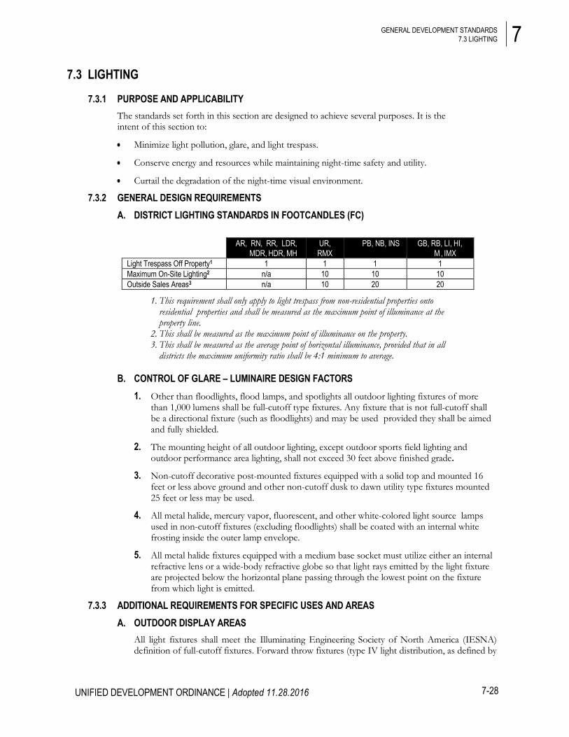
7.3.2 GENERAL DESIGN REQUIREMENTS A. DISTRICT LIGHTING STANDARDS IN FOOTCANDLES (FC)
AR, RN, RR, LDR, MDR, HDR, MH
UR, RMX
PB, NB, INS GB, RB, LI, HI, M , IMX
Light Trespass Off Property1 1 1 1 1 Maximum On-Site Lighting2 n/a 10 10 10 Outside Sales Areas3 n/a 10 20 20
1. This requirement shall only apply to light trespass from non-residential properties onto residential properties and shall be measured as the maximum point of illuminance at the property line.
2. This shall be measured as the maximum point of illuminance on the property. 3. This shall be measured as the average point of horizontal illuminance, provided that in all
districts the maximum uniformity ratio shall be 4:1 minimum to average.
B. CONTROL OF GLARE – LUMINAIRE DESIGN FACTORS 1. Other than floodlights, flood lamps, and spotlights all outdoor lighting fixtures of more
than 1,000 lumens shall be full-cutoff type fixtures. Any fixture that is not full-cutoff shall be a directional fixture (such as floodlights) and may be used provided they shall be aimed and fully shielded.
2. The mounting height of all outdoor lighting, except outdoor sports field lighting and outdoor performance area lighting, shall not exceed 30 feet above finished grade.
3. Non-cutoff decorative post-mounted fixtures equipped with a solid top and mounted 16 feet or less above ground and other non-cutoff dusk to dawn utility type fixtures mounted 25 feet or less may be used.
4. All metal halide, mercury vapor, fluorescent, and other white-colored light source lamps used in non-cutoff fixtures (excluding floodlights) shall be coated with an internal white frosting inside the outer lamp envelope.
5. All metal halide fixtures equipped with a medium base socket must utilize either an internal refractive lens or a wide-body refractive globe so that light rays emitted by the light fixture are projected below the horizontal plane passing through the lowest point on the fixture from which light is emitted.
7.3.3 ADDITIONAL REQUIREMENTS FOR SPECIFIC USES AND AREAS A. OUTDOOR DISPLAY AREAS
All light fixtures shall meet the Illuminating Engineering Society of North America (IESNA) definition of full-cutoff fixtures. Forward throw fixtures (type IV light distribution, as defined by

7
7-29
UNIFIED DEVELOPMENT ORDINANCE | Adopted 11.28.2016
GENERAL DEVELOPMENT STANDARDS 7.3 LIGHTING
the IESNA) are required within 25 feet of any public street right-of-way. Alternatively, directional fixtures (such as floodlights) may be used provided they shall be aimed and fully shielded.
B. LIGHTING FOR VEHICULAR CANOPIES Lighting under vehicular canopies shall be designed so as not to create glare off-site. Acceptable methods include one or more of the following:
1. Recessed fixture incorporating a lens cover that is either recessed or flush with the bottom surface of the vehicular canopy.
2. Surface mounted fixture incorporating a flat lens that provides a cutoff or shielded light distribution.
3. Other method approved by the Administrator.
C. SECURITY LIGHTING 1. Motion activated security lights or unshielded flood and spotlights, with 45 watts or less,
installed for security and activated by motion sensor, are permitted. These unshielded lights must be mounted and aimed in a manner that minimizes up-lighting and light trespass.
2. All floodlights shall be installed such that the fixture shall be aimed down at least 45 degrees from vertical floodlights and shall be positioned such that any such fixture located within 50 feet of a street right-of-way is mounted and aimed perpendicular to the right-of-way, with a side-to-side horizontal aiming tolerance not to exceed 15 degrees from perpendicular to the right-of-way.
3. All flood or spot lamps emitting 1,000 or more lumens shall be aimed at least 60 degrees down from horizontal or shielded such that the main beam from the light source is not visible from adjacent properties or the street right-of-way.
4. Landscape and decorative lighting using incandescent lighting of 40 watts or less is permitted, provided that the light is installed and aimed to prevent lighting build up and light trespass and shielded to prevent view from the public right-of-way.
5. Area “dusk to dawn” open-bottom lights, with photosensors that automatically turn the light on and off at certain levels of ambient illumination, are permitted. These lights must be full-cutoff.
D. OUTDOOR RECREATIONAL LIGHTING 1. Lights shall be shielded and positioned so as not to shine onto adjacent properties.
2. All fixtures used for event lighting shall be fully shielded or be designed or provided with Manufacturer’s Glare Control Package, so as to minimize up-light, spill-light, and glare.
3. Fixtures for outdoor recreational facilities must not exceed 80 feet in mounting height (this includes bases and/or other mounting structures) above finished grade.

7
7-30
UNIFIED DEVELOPMENT ORDINANCE | Adopted 11.28.2016
GENERAL DEVELOPMENT STANDARDS 7.3 LIGHTING
4. Fixtures shall be designed and aimed so that their beams fall within the primary playing area and the immediate surroundings, so that off-site direct illumination is significantly restricted (spillover levels at the property line must not exceed 2 footcandles).
E. BUILDING FACADE LIGHTING Floodlights, spotlights, or any other similar lighting shall not be used to illuminate buildings or other site features unless approved as an integral architectural element on the development plan. On-site lighting may be used to accent architectural elements, but not used to illuminate entire portions of building(s) or sign(s). Where accent lighting is used, the maximum illumination on any vertical surface or angular roof surface shall not exceed 5.0 average maintained footcandles. Building facade and accent lighting will not be approved unless the light fixtures are carefully selected, located, aimed, and shielded so that light is directed only onto the building facade and spillover light is minimized.
7.3.4 EXEMPTIONS AND PROHIBITIONS A. EXEMPTIONS
1. All temporary emergency lighting needed by the Sheriff or Fire Departments or other emergency services, as well as all vehicular luminaires, shall be exempt from the requirements of this ordinance.
2. All hazard warning luminaires required by Federal regulatory agencies are exempt from the requirements of this article, except that all luminaires used must be red and must be shown to be as close as possible to the federally required minimum lumen output requirement for the specific task.
3. Individual residential lighting that is not part of a site plan or subdivision plat for street or other common or public area outdoor lighting.
4. Lighting associated with landscape/holiday/festive/temporary uses.
5. Lighting of public art that has been permitted or otherwise approved by Lancaster County.
6. Other Municipal or State lighting installed for the benefit of public health, safety, and welfare.
7. All fixtures installed or temporarily used by public agencies, their agents, or contractors for the purpose of illuminating public streets.
8. Lighting of US Flags provided the flag standard does not exceed the maximum permitted building height for that district.
B. PROHIBITIONS 1. Laser Source Light: The use of laser source light or any similar high intensity light for
outdoor advertising or entertainment is prohibited.
2. Searchlights: The operation of searchlights for advertising purposes is prohibited.
3. Flashing Lights: Lights that flash, move, revolve, rotate, scintillate, blink, flicker, vary in intensity or color, or use intermittent electrical pulsation are prohibited.
4. Awning and Canopy Lighting: Awnings and canopies used for building accents over doors, windows, and etc. shall not be internally lit (i.e. from underneath or behind) so as to visually turn a translucent material into an internally illuminated material. Lighting may be installed under canopies that light the sidewalk, or downlights onto the architectural features of a building.

7
7-31
UNIFIED DEVELOPMENT ORDINANCE | Adopted 11.28.2016
GENERAL DEVELOPMENT STANDARDS 7.4 SIGNS
7.3.5 ADMINISTRATION A. LIGHT MEASUREMENT TECHNIQUE
Light level measurements shall be made at the property line of the property upon which the light to be measured is being generated. If measurement on private property is not possible or practical, light level measurements may be made at the boundary of the public street right-of-way that adjoins the property of the complainant or at any other location on the property of the complainant. Measurements shall be made at finished grade (ground level), with the light-registering portion of the meter held parallel to the ground pointing up. The meter shall have cosine and color correction and have an accuracy tolerance of no greater than plus or minus 5 percent. Measurements shall be taken with a light meter that has been calibrated within the year. Light levels are specified, calculated, and measured in footcandles (FC).
B. COMPLIANCE While not required to be provided with the submission of the site plan, projects may be required to provide the following information upon request by the Administrator:
1. Point-by-point footcandle arrays in a printout format indicating the location and aiming of illuminating devices. The printout shall indicate compliance with the maximum maintained footcandles required by this ordinance.
2. Description of the illuminating devices, fixtures, lamps, supports, reflectors, poles, raised foundations, and other devices (including but not limited to manufacturers or electric utility catalog specification sheets and/or drawings, and photometric report indicating fixture classification [cutoff fixture, wall pack, floodlight, etc.]).
3. If the Administrator does not request lighting information to be included for review with a site plan, this shall not relieve the applicant from compliance with the standards.
C. NONCONFORMING LIGHTING Any nonconforming lighting fixture lawfully in place or approved by the County prior to the adoption of this ordinance shall be exempt from these requirements. Routine maintenance, including changing the lamp, ballast, starter, photo control, lens, and other required components, is permitted for all existing fixtures. At the time that a nonconforming fixture, which was installed prior to the adoption of this ordinance, is replaced, moved, upgraded, or otherwise changed, the fixture must be replaced by either:
1. The same type of fixture that emits an equal or less amount of lumens as the original fixture, allows the trespassing of an equal or less amount of light onto neighboring properties, and restricts uplighting to an equal or less amount than the original fixture; or
2. A fixture that is in compliance with this ordinance.
7.4 SIGNS
7.4.1 GENERAL PURPOSE AND INTENT The sign regulations of this section are adopted under the zoning authority of the County in furtherance of the general purposes set forth in the Unified Development Ordinance. The purpose of this chapter is as follows:
• To encourage the effective use of signs as a means of communications in the unincorporated areas of Lancaster County;
• To maintain and enhance the aesthetic environment and the County's ability to attract sources of economic development and growth;

7
7-32
GENERAL DEVELOPMENT STANDARDS 7.4 SIGNS
UNIFIED DEVELOPMENT ORDINANCE | Adopted 11.28.2016
• To improve pedestrian and traffic safety;
• To minimize the possible adverse effect of signs on nearby public and private property; and
• To enable the fair and consistent enforcement of these sign regulations.
7.4.2 APPLICABILITY A. UDO ZONING PERMIT REQUIRED
Unless otherwise provided by this ordinance, no sign may be constructed, erected, placed, moved, enlarged, illuminated, or substantially altered within the County unless and until a UDO Zoning Permit has been obtained and the provisions of this section have been met. Additional permits may be necessary pursuant to the regulations in the state building code or other sections of this ordinance. No Zoning Permit shall be issued until a completed application, accompanied by the appropriate fee from the "Official Fee and Charge Schedule" for Lancaster County, has been filed with, reviewed, and approved by the Administrator.
B. ALTERATION OF SIGN FACE Repainting of a sign, if in conformance with the applicable standards of this chapter, shall be considered maintenance or repair and shall not require a permit. The changing of tenant name panels on multiple-tenant development signage shall not require a permit.
C. HISTORIC SIGNS The restoration and preservation of signs over 50 years old shall not require a Zoning Permit; however such signs may not be enlarged, moved, illuminated, or otherwise altered except in conformance with an approved Zoning Permit and the provisions of this section.
7.4.3 COMPUTATION OF SIGNAGE MEASUREMENTS A. COMPUTATION OF SIGN AREA
1. The area of a sign face shall be deemed to be the entire area within the smallest square or rectangle that will encompass the extreme limits of the writing, representation, emblem, or other display on the sign as illustrated at right.
2. The area shall also include any material or color forming an integral part of the background of the display or used to differentiate the sign from the backdrop or structure against which it is placed.
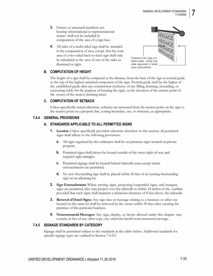
7
7-33
GENERAL DEVELOPMENT STANDARDS 7.4 SIGNS
UNIFIED DEVELOPMENT ORDINANCE | Adopted 11.28.2016
3. Frames or structural members not bearing informational or representational matter shall not be included in computation of the area of a sign face.
4. All sides of a multi-sided sign shall be included in the computation of area, except that the total area of a two-sided back-to-back sign shall only be calculated as the area of one of the sides as illustrated at right.
B. COMPUTATION OF HEIGHT The height of a sign shall be computed as the distance from the base of the sign at normal grade to the top of the highest attached component of the sign. Normal grade shall be the higher of the established grade after any construction (exclusive of any filling, berming, mounding, or excavating solely for the purpose of locating the sign), or the elevation of the nearest point of the crown of the nearest abutting street.
C. COMPUTATION OF SETBACK Unless specifically stated otherwise, setbacks are measured from the nearest point on the sign to the nearest point on a property line, zoning boundary, use, or structure, as appropriate.
7.4.4 GENERAL PROVISIONS A. STANDARDS APPLICABLE TO ALL PERMITTED SIGNS
1. Location: Unless specifically provided otherwise elsewhere in this section, all permitted signs shall adhere to the following provisions:
a. All signs regulated by this ordinance shall be on-premises signs located on private property.
b. Permitted signs shall always be located outside of the street right-of-way and required sight triangles.
c. Permitted signage shall be located behind sidewalk areas except where encroachments are permitted.
d. No new freestanding sign shall be placed within 20 feet of an existing freestanding sign on an adjoining lot.
2. Sign Encroachments: Where awning signs, projecting/suspended signs, and marquee signs are permitted, they may project over the sidewalk to within 18 inches of the curbline provided that such signs shall maintain a minimum clearance of 8 feet above the sidewalk.
3. Removal of Dated Signs: Any sign face or message relating to a business or other use located on the same lot shall be removed by the owner within 30 days after vacating the premises of this particular business.
4. Noncommercial Messages: Any sign, display, or device allowed under this chapter may contain, in lieu of any other copy, any otherwise lawful noncommercial message.
7.4.5 SIGNAGE STANDARDS BY CATEGORY Signage shall be permitted subject to the standards in the tables below. Additional standards for specific signage types are outlined in Section 7.4.5.C.

7
7-34
GENERAL DEVELOPMENT STANDARDS 7.4 SIGNS
UNIFIED DEVELOPMENT ORDINANCE | Adopted 11.28.2016
A. ATTACHED SIGN STANDARDS
Permitted Location Maximum Area Maximum Height Other Requirements Maximum
Number
A. Wall Signs
AR, RR, RN, LDR, MDR, HDR, UR, RUB, PB, HDR
(non-residential uses only, but not Home
Occupations)
30 sq ft OR 1 sq ft per linear ft of building wall, whichever is greater. 50 sq ft building maximum
No sign shall extend above the roofline
12 inch maximum
protrusion
None. May not exceed
maximum calculated
square footage on any wall
(cannot move allotment from
one wall to another)
NB, INS, RMX, MX, IMX
30 sq ft OR 1 sq ft per linear ft of building wall, whichever is greater. 50 sq ft building maximum.
LI, HI, GB, RB 50 sq ft OR 1sq ft per
linear ft of building wall, whichever is greater. 75 sq ft building maximum.
B. Window Signs
All businesses, except Home
Occupations, with at least 30 linear feet of windows fronting on a public right-of-way
50% of the gross glass area on any one side of
the first floor of a building
n/a
Signs shall not be illuminated except for
neon lettering on window signs
n/a
C. Awning Signs
All businesses, except Home
Occupations, on first floor awnings only
50% of the awning area
n/a Signs shall not be illuminated
1 per public entrance
D. Theatre Marquee Signs
Theatres only
100 sq ft
May not exceed the maximum
height for the zoning district
Such signs must be perpendicular to the
facade of the building, or at a 45 degree angle from the corner of the building
1 per theatre
E. Projecting / Suspended Signs
All businesses except Home Occupations
4 sq ft per side No sign shall extend above
roofline
All lettering and graphics shall be permanent
1 per public entrance
F. Address / Tenant Identification Signs
All Districts
6 sq ft per tenant
n/a
Signs on mailboxes and newspaper tubes may be located in the right-of-way as per applicable postal
regulations
Street numbers (only) may be painted on the curb
1 per public entrance

7
7-35
GENERAL DEVELOPMENT STANDARDS 7.4 SIGNS
UNIFIED DEVELOPMENT ORDINANCE | Adopted 11.28.2016
B. FREESTANDING SIGN STANDARDS
Permitted Location Maximum Area Maximum Height Other Requirements Maximum
Number
A. Monument / Ground Signs
AR, RR, RN, LDR, MDR, HDR, UR, PB (non-residential uses only, but not Home
Occupations)
25 sq ft per sign 6 ft
5 ft minimum front setback and 10 ft minimum side
setback. No sign shall be located in any required buffer yard or within 20 ft of any right-of-
way intersection. Signs shall have a base at least 50% wider than the overall width of the sign OR include landscape plantings at the base of
the sign. Additional standards and
allowances apply for multi- tenant commercial
developments according to the provisions of
Chapter 5.
1 per street
frontage NB, INS, RMX,
MX, IMX, 40 sq ft per sign
10 ft
INS
40 sq ft for the first sign. One additional sign per street front of 30 sq ft
10 ft for first sign, 6 ft for additional
signs
1 per 300 ft of development lot
frontage
LI, HI, GB, RB
40 sq ft OR 0.25 sq ft per linear foot of lot frontage on streets up to 100 sq ft
total
10 ft
1 per street
frontage
B. Bracket Signs
Business and Home Occupations in all
districts except IMX 4 sq ft per side 4.5 ft
5 ft minimum front setback and 10 ft minimum side
setback No sign shall be located in any required buffer yard or within 20 ft of any right-of-
way intersection.
1 per public entrance
C. Portable / A- Frame Signs
NB, PB, RMX, MX
8 sq ft per side, no more than two sides 4.5 ft
Signs may be located on a public sidewalk, but must
maintain at least 48 inches of unobstructed pedestrian
space. Signs must be placed within 20 ft of the main
entrance. The sign must be removed
at the close of business each day.
Illumination of signs is prohibited.
1 per public
entrance

7
7-36
GENERAL DEVELOPMENT STANDARDS 7.4 SIGNS
UNIFIED DEVELOPMENT ORDINANCE | Adopted 11.28.2016
C. PERMITTED SIGNAGE TYPES – ATTACHED SIGNS
A. Wall Signs: Flat signs, channel lettering, or three-dimensional signs which are painted or attached (parallel) to the wall of a building or structure.
B. Window Signs: Flat signs or lettering which are painted, hung, or otherwise affixed over or behind the window of a building or structure.
C. Awning Signs: Signs integrated into traditional storefront awnings that project over a sidewalk from the building facade.
D. Theatre Marquee Signs: Three-dimensional signs projecting from the side of a building which may extend above the roofline and/or incorporate changeable type.
E. Projecting/ Suspended Signs: Pedestrian-scaled signs mounted to the side of the building or underside of a balcony or arcade which can be read from both sides.
F. Address/Tenant Identification Signs: Incidental signs that list tenants, unit numbers, address contact information, hours of operation, and similar non-commercial characteristics in a multi-tenant building with common entry.

7
7-37
GENERAL DEVELOPMENT STANDARDS 7.4 SIGNS
UNIFIED DEVELOPMENT ORDINANCE | Adopted 11.28.2016
D. PERMITTED SIGNAGE TYPES – FREESTANDING SIGNS
A. Monument / Ground Signs: Signs erected independent of a building, with an integral support structure.
B. Bracket Signs: Minor or secondary signs which are used to identify the address of a building, or to identify the profession, family, organization, business, etc., occupying the building.
C. Portable/ A-Frame Signs: Pedestrian scaled non- permanent signs which are used to display menus, daily specials, sale announcements, and similar messages.
7.4.6 OTHER PERMITTED SIGNAGE STANDARDS The following sign types shall be permitted subject to the additional standards below and shall require a UDO Zoning Permit as outlined in Chapter 9.
A. DRIVE-THRU MENU BOARDS 1. Location/Placement: Such signs shall be allowed only as an accessory use to a restaurant
having a drive-through window.
2. Maximum Number: 2 menu boards per lot shall be permitted.
3. Surface Area: 35 square feet maximum per sign.
4. Height: 8 feet maximum.
B. GAS PUMP ISLAND CANOPY SIGNS 1. Location/ Placement
a. Such signs shall be allowed only as a part of an approved Vehicle Services - Minor Maintenance/Repair (Gas Station) use.
b. Such signs shall be attached to the outer, vertical surface of the gas pump island canopy roof and shall project not more than 18 inches from said vertical surface.
c. No signs shall hang from, or under, the canopy; no signs shall be placed on the top, horizontal roof surface of the canopy; and no signs shall extend beyond the top, bottom, and side edges of any canopy surface.
Source: City of Wilson, NC
7
7-38
GENERAL DEVELOPMENT STANDARDS 7.4 SIGNS
UNIFIED DEVELOPMENT ORDINANCE | Adopted 11.28.2016
2. Surface Area: Such signs shall cover no more than 50 percent of the lateral surface area of any given vertical surface.
3. Height: The maximum letter or insignia/logo height shall be 24 inches.
C. CHANGEABLE SIGNS 1. Manually-Activated Changeable Signs: Any permitted sign may be a manually-activated
changeable sign.
2. Electrically-Activated Changeable Signs (On-Premises): Any permitted sign in the GB, RB, LI, and HI districts, or on any property with 500 feet or more of frontage on a street with at least 2 travel lanes in each direction, may be, or include as part thereof, an electrically-activated changeable sign not to exceed 20 square feet in area, provided that the size of the sign may not exceed the area originally allotted.
3. Permitted signs in the NB, RMX, MX, and INS Districts may be, or include as part thereof, only time and weather informational signs as electrically-activated changeable signs. Time and weather messaging restrictions shall not apply to schools, colleges and universities, public safety stations, worship centers, public recreation facilities, and hospital uses. (Ord. No. 2019-1609, 10.14.19)
4. In multi-tenant commercial developments of 40 or more acres, up to 200 square feet or 50 percent, whichever is less, of any allotted freestanding sign may be an electrically-activated changeable sign.
D. TEMPORARY COMMERCIAL SIGNS Unless specified elsewhere in this chapter, temporary signage shall be permitted for all non- residential uses, except Home Occupations, subject to the following standards:
1. Maximum Number: 1 per street frontage per business.
2. Surface Area: 16 square feet maximum per sign.
3. Standards for Businesses Under Construction: Temporary signs announcing the opening of a business shall be permitted subject to the following:
a. Only 1 such sign shall be allowed per business.
b. Such sign(s) shall not exceed 16 square feet in area or 6 feet in height.
c. Such signs shall only be placed on the lot the announced business will occupy.
d. Such signs shall be permitted only during that time that a valid building permit is in effect for the announced business.
e. Such sign(s) shall be removed upon the construction of any otherwise authorized freestanding sign on the lot or when the announced business opens for business, whichever comes first.

7
7-39
GENERAL DEVELOPMENT STANDARDS 7.4 SIGNS
UNIFIED DEVELOPMENT ORDINANCE | Adopted 11.28.2016
E. MULTI-TENANT COMMERCIAL DEVELOPMENTS 1. Signage Standards: Multi-tenant commercial developments of 8 acres or more or with
500 or more feet of street frontage shall be entitled to the following additional signage:
2. Entrance/Directional Signs: Additional entrance/directional signs for multi-tenant commercial developments of 40 or more acres are permitted subject to the following provisions:
a. Up to 2 such signs are permitted for each driveway entrance. Such signs must be placed within 50 feet of the driveway from which the allocation is drawn, but outside any sight visibility triangle as outlined in Section 9.7.1.E.
b. Maximum height is 10 feet.
c. The maximum area of any one sign is 40 square feet.
F. OFF-PREMISES ADVERTISING SIGNS (BILLBOARDS) Unless otherwise specified in this chapter, off-premises advertising signs shall be allowed in the LI and HI Districts only subject to the following standards:
1. Signage Standards
2. Additional Standards
Outdoor advertising signs (billboards) shall be located only in the I-1 and I-2 Districts.
a. No billboard shall have more than two sign surface areas mounted back to back and each face shall be the same height and width;
b. No more than one billboard shall be allowed on a lot;
c. No billboard shall be erected upon the roof of any building, attached to any building or painted or posted on any building;
Number of Signs
Permitted
Maximum Height
Maximum Area Per
Development
Maximum Sign Area per Street
Frontage
Additional Requirements
Entire development
signage
2 signs for each adjacent
street frontage
20 ft - RB District 10 ft – all other
districts
The greater of 70 sq ft OR
0.25 sq ft per development frontage on
streets
135 sq ft - RB District
120 sq ft – all other districts
Signs must be placed a
minimum of 500 ft apart
Individually platted lots within the
development
1 sign for each adjacent
street frontage
8 ft
n/a
40 sq ft.
n/a
Districts Maximum Total Height
Display Surface Dimensions Maximum Area
LI, HI
24 ft Maximum height – 10 ft
Maximum width – 15 ft
150 sq ft per side, including copy extensions

7
7-40
GENERAL DEVELOPMENT STANDARDS 7.4 SIGNS
UNIFIED DEVELOPMENT ORDINANCE | Adopted 11.28.2016
d. No billboard shall be set back less than the height of the sign from any public/private right-of-way or easement. No billboard shall exceed 24 feet in height at its highest point.
e. No billboard shall be less than 1,500 feet from any other billboard located on the same side of the same public/private right-of-way, public or private easement;
f. At street intersections, no billboard shall be located less than 500 feet from any other billboard sign.
g. No billboard shall be located within 200 feet of any right-of-way of any underpass, overpass, bridge, tunnel or any plaza serving such facility;
h. No billboard shall be located less than 500 feet from any residential district and/or use;
i. The maximum sign surface area allowed for such a sign shall be 150 square feet;
j. Such signs shall only be allowed on parcels which contain at least 150 feet of road frontage.
k. Such signs shall be permitted on premises where other businesses or permitted uses are established provided such signs are located at least 75 feet from any part of the property occupied by any portion of the established use including off-street parking areas.
l. Signs subject to regulation under SCDOT outdoor advertising control may require a permit from the South Carolina Department of Transportation in addition to any permit required under this ordinance.
3. Commercial Electronic Variable Message Signs (CEVMS)
a. Messages on a CEVMS shall remain fixed for a period of at least ten (10) seconds between changes. The change sequence must be accomplished within an interval of two (2) seconds or less.
b. A CEVMS shall not include animated, continuous, moving, rolling, scrolling messages, no fluttering, blinking, of flashing elements or video displays.
c. A CEVMS shall have an automatic dimmer and a photo cell sensor to adjust the illumination intensity, or brilliance of the sign so that it shall not cause glare or impair the vision of motorists, and shall not interfere with any driver's operation of a motor vehicle. The CEVMS should not exceed a maximum illumination of seven thousand five hundred (7,500) nits (candelas per square meter) during daylight hours and a maximum illumination of five hundred (500) nits between dusk to dawn as measured from the sign's face at maximum brightness. Any external illumination devices shall be effectively shielded so as to prevent beams or rays of light from being directed at any portion of a street or highway, or any residential use.
4. Location/ Placement
a. Signs must be at least 300 feet from any MH, LDR, MDR, HDR, or UR (as outlined in Section 2.4).
b. All portions of a sign must be at least 10 feet from any overhead electric wiring and public utility guy wire.
c. Signs must be at least 1,500 feet from any other off-premises advertising sign, measured from centerpoint to centerpoint.
5. General Standards

7
7-41
GENERAL DEVELOPMENT STANDARDS 7.4 SIGNS
UNIFIED DEVELOPMENT ORDINANCE | Adopted 11.28.2016
a. "Copy extensions" (portions of copy extending beyond the outer edge of the sign frame) are allowed provided they extend no more than 6 feet beyond the outer edge of the sign frame, they do not exceed 100 square feet in area (per side), and they comply with all other requirements.
b. Double-faced back-to-back signs are allowed.
c. Signs shall not be attached to any building and must meet the principal building setback requirements for the district in which they are located.
d. Signs shall meet wind load requirements that meet or exceed the most recently approved International Building Code (IBC).
e. The area within 25 feet, in all directions, from the base of the sign shall be landscaped with ground cover, shrubs, etc., so as to screen the base of the sign. The sign owner shall maintain this landscaping as long as the sign occupies the premises and shall keep this area free from debris and undergrowth.
f. A site plan/landscaping plan shall be prepared by a registered engineer or architect for each sign. The landscape plan must be approved by the Administrator.
g. Color lighting is prohibited on all signs except permitted electrically-activated changeable signs.
6. Off-Premises Signage with Changeable Copy: Off-premises signage which incorporate electrically-activated or other changeable copy must be at least 2,000 feet from any other off-premise advertising sign, measured from centerpoint to centerpoint.
7. Standards for Existing Signs: When the property upon which such sign is erected is changed to a district that does not permit such signs, the sign shall be removed within 90 days of such zoning change.
G. RESIDENTIAL DEVELOPMENT ENTRY SIGNAGE Each subdivision or multi-family development is permitted one of the following options for entry signage at each major entrance to the subdivision or development:
1. Option 1: A maximum of 2 permanent monument signs located on private property or on the walls of a building with a maximum size of 32 square feet for each sign and a maximum height of 6 feet; OR
2. Option 2: One monument sign located in the median of any divided entrance with a maximum height of 6 feet and a maximum size of 32 square feet and subject to the following additional provisions:
a. The sign shall be set back 25 feet from the right-of-way of the intersecting street;
b. Any lighting fixtures shall be attached to or incorporated in the sign in such a fashion so as not to constitute a safety hazard or mowing obstruction;
c. Detailed drawings of the sign and its location must be approved by the Administrator prior to construction of the sign;
d. The sign shall be maintained by the developer and the County shall not be responsible for any special landscaping on the median.

7
7-42
GENERAL DEVELOPMENT STANDARDS 7.4 SIGNS
UNIFIED DEVELOPMENT ORDINANCE | Adopted 11.28.2016
7.4.7 SIGNS NOT REQUIRING A PERMIT The following signs shall not require a UDO Zoning Permit, unless illuminated and a permit is required as per the electrical code, and shall not be counted against any allotments, but shall conform to all applicable requirements of this section.
A. WINDOW DISPLAYS Merchandise, pictures or models of products, or services that are incorporated as an integral part of an interior window display.
B. PLAQUES OR HISTORICAL MARKERS Memorial plaques, cornerstones, historical tablets, and similar devices.
C. ART & ARCHITECTURAL FEATURES Integral decorative or architectural features of buildings or works of art, provided such features or works of art do not contain advertisements, trademarks, moving parts, or lights.
D. TEMPORARY HOLIDAY DECORATIONS Displays, including lighting, erected in connection with the observance of holidays. Such displays shall not be considered as illuminated signs, and they shall be removed within 30 days following the holiday.
E. NONCOMMERCIAL SIGNS ON RESIDENTIAL LOTS Any ground/freestanding sign containing any lawful noncommercial message on a single family or multifamily residential lot may be erected subject to the following:
1. Such signs shall not exceed 4 square feet in area, and 3 feet in height.
2. The number of these signs is limited to 1 per lot. However, a corner lot can have 2.
3. In no event shall there be more than 1 such sign allowed per lot.
F. POLITICAL SIGNS ON PUBLIC RIGHTS-OF-WAY Political signs may be located within a street right-of-way, except fully controlled access highways, subject to the following provisions:
1. Permission must be granted from the property owner if sign is located outside the right-of-way.
2. Such signs may not exceed 6 square feet in area and 42 inches in height.
3. Such signs shall not be closer than 3 feet from the edge of pavement of the road.
4. Such signs shall not obscure motorist visibility at an intersection.
5. Such signs shall not obscure or replace any other sign.
6. In the event of a primary runoff election, political signs for the candidates involved may remain on display until 15 days after the runoff election.
G. SIGNS ON ATHLETIC FIELDS Scoreboards and internally-oriented signs on athletic fields.
H. VENDING MACHINE, ATM, AND GASOLINE PUMP SIGNS Signs attached to and made an integral part of a vending machine, automatic teller machine, or gasoline pump if advertising or giving information about the products or services dispensed or vended by that machine.

7
7-43
GENERAL DEVELOPMENT STANDARDS 7.4 SIGNS
UNIFIED DEVELOPMENT ORDINANCE | Adopted 11.28.2016
I. REAL ESTATE SIGNS 1. Individual Lots For Sale
a. Such signs may be no greater than 4 square feet in a residential area and 4 feet in height in a residential area and no greater than 16 square feet and 6 feet in height in a commercial area. (Ord. No. 2018-1492, 2.12.18)
b. One sign is permitted for each street front on each lot.
c. Real estate signs shall be removed within 15 days after the closing of the sale, rental, or lease of the property.
d. Such signs shall only be located on property for sale or lease.
2. On-Premises Subdivision Sales Signs
a. Such signs may be no greater than 16 square feet in area and 6 feet in height.
b. One sign is permitted for each entrance to the subdivision.
c. Such signs shall be removed when all of the lots have been sold or within 5 years of erection, whichever is less.
J. YARD SALE SIGNS 1. Temporary signs announcing a yard or garage sale not over 4 square feet in area. One sign for
each street front on each lot.
2. Signs must be removed within 7 days to avoid penalties.
3. Signs cannot be placed on street signs or utility poles.
K. SPECIAL PUBLIC OR NON-PROFIT EVENT SIGNS Signs may be erected by public or non-profit organizations such as schools, churches, and farmer’s market associations for promoting special events as follows:
1. Signs for public events such as fund drives, fairs, festivals, sporting events, etc. may be displayed for a period of 15 days. Such signs shall be removed within 7 days of the end of the special event.
2. Signs are limited to 32 square feet in area, 6 feet in height, and 1 sign along each street frontage.
3. Off-premises signs shall be permitted on private property provided that they are located a minimum distance of 2,640 feet (or ½ mile) from any other off-premises sign advertising the same event.
L. CONSTRUCTION SIGNS Temporary signs for construction on or development of a lot shall be permitted subject to the following:
1. Such signs shall only be allowed during the time such construction or development is actually in progress, and only when placed on the lot in question (and not on a public right-of-way).
2. One such sign shall be allowed per contractor and/or financial institution, and it shall not exceed 16 square feet in area.
3. Sign permits are required before installation.

7
7-44
GENERAL DEVELOPMENT STANDARDS 7.4 SIGNS
UNIFIED DEVELOPMENT ORDINANCE | Adopted 11.28.2016
M. FLAGS, ETC. Flags or emblems of political, civic, philanthropic, educational, or religious organizations are permitted provided:
1. The height of any pole shall not exceed the maximum building height for the district;
2. Flags do not extend into the street; and
3. Flags are attached to a pole, rope, or building on only one side.
4. Feather flags are not allowed.
N. GOVERNMENTAL SIGNS Any sign, symbol, or device erected and maintained by a federal, state, county, or municipal government, or any such governmental agency, in the performance of their duties such as regulatory signs, identification/directional signs, welcome signs, legal notice signs, and traffic control signs.
O. PRIVATE TRAFFIC CONTROL SIGNS Traffic control signs erected on private property that conform with the design and installation requirements stipulated in the latest edition of the "Manual of Uniform Traffic Control Devices," as amended, and "Standard Highway Signs," as published and amended by the U.S. Department of Transportation, Federal Highway Administration.
P. PARKING LOT DIRECTORY SIGNS Public parking lot directory signs are permitted in parking lots operated by a public agency or government subject to the following:
1. Only 1 such sign per parking lot.
2. Maximum sign area is 32 square feet.
3. May display advertising for businesses that directly abut the parking lot in which the sign is located only.
Q. DIRECTIONAL / IDENTIFICATION SIGNS Such signs displayed strictly for the direction, safety, or convenience of the public, including signs which identify restrooms, parking area entrances or exits, freight entrances and similar devices, and warning, danger and no-trespassing signs. These signs may bear only names and/or addresses of the occupants of the premises and/or a logo of the business, or product sold, on the premises.
1. Maximum size is 6 square feet;
2. Maximum height of freestanding identification signs is 4 feet;
3. Freestanding identification signs are limited to the greater of 1 such sign per driveway or, 1 such sign per lot.
R. HAZARD IDENTIFICATION SIGNS Hazard identification signs outlined in the National Fire Protection Association “NFPA 704”.

7
7-45
GENERAL DEVELOPMENT STANDARDS 7.4 SIGNS
UNIFIED DEVELOPMENT ORDINANCE | Adopted 11.28.2016
7.4.8 PROHIBITED SIGNS The following signs shall be prohibited in all districts:
A. SIGNS ON ROADSIDE APPURTENANCES Except as otherwise provided, no sign shall be erected, maintained, painted, or drawn on any tree, rock, natural feature, utility pole, overpass, traffic control device, street light, or other similar utility pole.
B. SIGNS MEANT TO BE READ IN SERIES No sign shall be permitted which uses a series of 2 or more signs placed in a line parallel to a roadway, or in similar fashion, all carrying a single advertising message, part of which is contained on each sign.
C. SIGNS OBSTRUCTING ACCESS No sign shall be erected or maintained so as to obstruct any fire escape, window, door, or other opening used as a required means of egress or so as to prevent free passage from one part of a roof to any other part thereof. No sign shall be attached in any form, shape, or manner to a fire escape, or placed in such a manner as to interfere with any opening required for ventilation.
D. SIGNS RESEMBLING TRAFFIC SIGNALS No sign shall be erected which simulates an official traffic-control or warning sign in such a manner as to, or would in any way, confuse, or mislead traffic.
E. ANIMATED/FLASHING SIGNS Except as otherwise provided, flashing signs, beacons, signs using intermittent or animated or effect, and revolving signs are prohibited.
F. ROOF SIGNS Signs placed anywhere on a roof of a structure are prohibited.
G. PORTABLE SIGNS Portable signs are prohibited.
H. OFF-PREMISE ADVERTISING Off-premise advertising signs are prohibited.
I. SIGNS ON MOTOR VEHICLES Signs placed anywhere on a motor vehicle or trailer, including digital and/or animated signs are prohibited.
J. OTHER
Any sign which is not listed as being permitted or which is structurally unsafe or hazardous.
7.4.9 SIGN ILLUMINATION A. ILLUMINATION STANDARDS
Except as otherwise provided by this chapter, all signs may be illuminated subject to the requirements below.
1. Shielding Required: Illuminated signs giving off light resulting in glare, blinding, or any other such adverse effect on traffic shall not be erected or maintained.

7
7-46
GENERAL DEVELOPMENT STANDARDS 7.4 SIGNS
UNIFIED DEVELOPMENT ORDINANCE | Adopted 11.28.2016
2. Setback Required: Except for permitted subdivision entrance signs, all illuminated signs shall be setback at least 50 feet from any side or rear property line shared with an AR, RR, RN, MH, LDR, MDR, HDR, and UR District.
3. Lighting: All lighting shall be in conformance with the provisions within this chapter.
7.4.10 MAINTENANCE AND UPKEEP OF SIGNS All signs shall be maintained in a state of good repair. No sign shall be erected or allowed to remain erected that is structurally unsafe, hazardous, and in the opinion of the Administrator, constitutes a danger to public safety. If in the opinion of the Administrator, any sign should become insecure, in danger of falling, or otherwise unsafe, the owner thereof or the person or firm maintaining the sign shall, upon written notice from the Administrator, secure or remove the sign within 10 days after written notification is delivered. If such sign is not removed or repaired in a manner approved by the Administrator within 10 days after written notification is delivered, the Administrator shall have the right to remove the sign and dispose of the sign.
7.4.11 VIOLATIONS A. VIOLATIONS
1. Signs on Public Property: Any sign installed or placed on public property, except in conformance with the requirements of this section, shall be forfeited to the public and subject to confiscation.
2. Other Violations: Any of the following shall be a violation of this ordinance and shall be subject to the enforcement remedies and penalties provided by Chapter 9 of this ordinance and by state law:
a. To install, create, erect, place, enlarge, enhance, or maintain any sign in a way that is inconsistent with the provisions of this ordinance.
b. To install, create, erect, place, enlarge, or enhance any sign requiring a permit without such a permit.
c. To install, create, erect, enlarge, place, enhance, or maintain any sign in a way that is inconsistent with any plan or permit governing such sign or the zoning lot on which the sign is located.
d. To fail to remove any sign that is installed, created, erected, placed, or maintained in violation of this ordinance.
e. Failure to comply will result in penalties of a minimum of $500.00 per day.
3. Separate Violations: Each sign installed, created, erected, placed, or maintained in violation of this ordinance shall be considered a separate violation when applying the penalty provisions of this ordinance. Each such day of a continued violation shall be considered a separate violation when applying the penalty provisions of this ordinance.