60268194 ACE Initial Biological Site Assessment Rpt - Final
46
35(/,0,1$5< 6,7( &+$5$&7(5,=$7,21 )25 %,2/2*,&$/ 5(6285&(6 )25 7+( $&( 3+2(1,; 352-(&7 6$1 %(51$5',12 &2817< &$/,)251,$ Prepared for: ACE Cogeneration – Trona Operating Partners PO Box 66 Trona, California 93592 Prepared by: AECOM 1420 Kettner Boulevard, Suite 500 San Diego, California 92101 Phone: (619) 233-1454 Fax: (619) 233-0952 June 1, 2012
Transcript of 60268194 ACE Initial Biological Site Assessment Rpt - Final

�
�35(/,0,1$5<�6,7(�&+$5$&7(5,=$7,21�)25��
%,2/2*,&$/�5(6285&(6�)25�7+(�
$&(�3+2(1,;�352-(&7�6$1�%(51$5',12�&2817<��&$/,)251,$�
Prepared for:�
ACE Cogeneration – Trona Operating Partners PO Box 66
Trona, California 93592
Prepared by:�
AECOM 1420 Kettner Boulevard, Suite 500
San Diego, California 92101 Phone: (619) 233-1454 Fax: (619) 233-0952
June 1, 2012


ACE Phoenix Project Biological Site Assessment Page i 60268194 ACE INITIAL BIOLOGICAL SITE ASSESSMENT RPT - FINAL 6/7/2012
7$%/(�2)�&217(176� 6HFWLRQ� 3DJH
1.0� INTRODUCTION .............................................................................................................. 1�
2.0 � PROJECT LOCATION ...................................................................................................... 1�
3.0 � METHODS ......................................................................................................................... 7�
4.0 � ENVIRONMENTAL SETTING ........................................................................................ 7�4.1 � Vegetation Communities .........................................................................................8�4.2 � Jurisdictional Waters and Hydrological Features ..................................................10�4.3 � Special-Status Species ...........................................................................................13�
5.0� SUMMARY AND RECOMMENDATIONS................................................................... 26�
6.0 � LITERATURE CITED ..................................................................................................... 28� APPENDICES A Botanical and Wildlife Species Observed B MGS Habitat Assessment
�

Page ii ACE Phoenix Project Biological Site Assessment 60268194 ACE INITIAL BIOLOGICAL SITE ASSESSMENT RPT - FINAL 6/7/2012
/,67�2)�),*85(6��)LJXUH� 3DJH 1 � Regional Location ................................................................................................................2�2� Project Location ...................................................................................................................3�3� Vegetation Communities .....................................................................................................5�4 � Hydrology ..........................................................................................................................11�5 � Regional Database Records ...............................................................................................15
/,67�2)�3+2726��3KRWR� 3DJH 1 View, looking to the southeast from the west corner of Area 6, demonstrating
the low diversity and coverage within the desert saltbush scrub habitat present on-site. ................................................................................................................................20�
2 Desert tortoise exclusion fencing present around the ash landfill in Area 7. ....................20�
/,67�2)�7$%/(6��7DEOH� 3DJH Table 1 Vegetation Communities Occurring within the Proposed ACE Phoenix Project Areas
and Gas Pipeline (Acres) .....................................................................................................8�Table 2 Special-Status Plant and Animal Species with the Potential to Occur within the Vicinity
of the Proposed Project Boundary .....................................................................................17�Table 3 Survey and Permit Recommendations for Key Biological Resources .............................26�

ACE Phoenix Project Biological Site Assessment Page iii 60268194 ACE INITIAL BIOLOGICAL SITE ASSESSMENT RPT - FINAL 6/7/2012
�([HFXWLYH�6XPPDU\��
Trona Operating Partners is proposing to replace the existing ACE Cogeneration Facility located in Trona, CA with a new combined-cycle and solar energy hybrid facility referred to as the ACE Phoenix Project (Project). The Project area for the combined cycle plant and solar arrays associated with this project has been divided into nine areas based on the current usage and property lines plus an approximately 3.5 mile long pipeline upgrade. AECOM performed a habitat assessment in May 2013 on this proposed Project area. Of the roughly 344 acres assessed, AECOM determined that only about half (173 acres) is covered with desert saltbush scrub habitat which, although poor quality, has the potential to support wildlife. The rest of the site is developed with existing structures (44.6 acres) or covered by disturbed habitat (126 acres). AECOM concluded that the following species are the only ones with any potential to occur within the Project area and/or to use the area for foraging: Clokey’s cryptantha, Amargosa beardtongue, Mohave ground squirrel (MGS), desert tortoise, burrowing owl, prairie falcon, golden eagle, desert kit fox, and American badger. For almost all of these nine species, the probability of occurrence or use of the site is considered to be low to very low. Only the MGS is thought to have a moderate possibility of occurrence on this site. Based on the poor habitat quality, AECOM’s recommendations for conducting further biological surveys are provided in Section 5.0 of the report. In summary, we suggest the following biological resources survey approach:
1. Starting with summer 2012, conduct avian point counts (to be determined with the agencies) once per season over a year.
2. Perform a protocol desert tortoise survey within desert saltbush scrub habitat in the Fall 2012, including zone of influence and CEC buffer surveys. During the desert tortoise surveys, also look for sign of burrowing owl, kit fox and American badger. Presuming no sign of these species is found, our proposal is to conduct pre-construction surveys only for these wildlife species.
3. If deemed necessary by the resource agencies, conduct a botanical survey in April 2013. 4. Determine if there is existing survey data for golden eagle, and discuss with the agencies
the need for further surveys given the absence of nesting habitat within one-mile of the site, as well as the poor foraging habitat on the site and gas pipeline route.
5. Further evaluate whether surveys will be conducted or presence assumed for the MGS. Meetings are being conducted with the involved biological resources agencies to determine the acceptability of this approach for permitting the Project.


ACE Phoenix Project Biological Site Assessment Page 1 60268194 ACE INITIAL BIOLOGICAL SITE ASSESSMENT RPT - FINAL 6/7/2012
���� ,1752'8&7,21� This draft biological resources summary was prepared to characterize the ACE Phoenix Project (Project) with respect to environmental sensitivity, California Environmental Quality Act level review, and the resource permitting processes. Trona Operating Partners has begun feasibility and design planning for the proposed Project. The proposed Project would consist of a new natural-gas-fired power plant on the current ACE Cogeneration Company facility site (approximately 25 acres), with 60 acres of the remaining plant property and approximately 190 acres of Searles Valley Minerals (SVM) land to the west and north of the ACE site to be potentially used as a solar field. The repowering project would replace the existing coal-fired cogeneration facility with a combined-cycle power plant and up to 40 MW of solar power (using a technology yet to be determined) which will replace power from the combined-cycle plant. The net power generation from the facility is expected to be up to 170 MW. An expansion of an approximately 3.5-mile-long pipeline would also be associated with the Project. ����� 352-(&7�/2&$7,21�� The proposed Project is located approximately 18 miles northeast of Ridgecrest along the State Highway 178 corridor near the towns of Argus and Trona, San Bernardino County, California (Figure 1). The proposed Project is located in the Searles Valley, and Searles Lake is located immediately to the southeast. Searles Valley and Searles Lake are bounded by the Argus Mountain Range to the west and Slate Mountain Range to the east (Figure 1). The potential power plant portions of the proposed Project, including up to 300 acres of proposed solar field, are located just north of State Highway 178 and are divided up into nine areas (Figure 2). The power plant site is located entirely on private land owned by Searles Valley Minerals, Inc. The new pipeline would be located parallel to an existing Pacific Gas and Electric (PG&E) pipeline and within an existing PG&E right-of-way (ROW). The northern end of the proposed pipeline begins at the Trona District Regulator Station just northeast of the intersection of First Street and State Highway 178 in Argus, California (Figure 3). The proposed pipeline will run in a southerly direction parallel to the Trona Railway and State Highway 178 until reaching PG&E’s Westend Primary Regulator Station at the southern end in Westend, California (Figure 3). The PG&E ROW runs through private property, the Trona Railway ROW, and small portions of Bureau of Land Management (BLM) land.

Source: USGS 7.5' Topo Quad Trona East 1982; Trona West 1983; West End 1973; Searles Lake 1973
Figure 1Regional Location
AC
E Phoenix Project Biological Site A
ssessment
Scale: 1:36,000;
Path: \\ussdg2fp001.na.aecomnet.com
\Data\Projects\2012\60268194\06G
IS\6.3_Layout\BioSiteAssmt\fig1_RegionalM
ap.mxd, 6/6/2012, irelandm
3,000 3,0000 Feet
I
!\
SITELOCATION
1 inch = 3,000 feet

Page x-xxACE Phoenix Project Biological Site Assessment
6RXUFH��)(0$�0DS�6HUYLFH�&HQWHU�������1+'�����
6FDOH������������
Figure 2Project Location
Path: P:\2012\60268194\06GIS\6.3_Layout\BioSiteAssmt\fig2_ProjectLocation.mxd, 6/6/2012, irelandm
���� � ��������� 0LOHV
Legend$SSUR[LPDWH�����PLOH�3*(�*DV�/LQH
Survey Boundaries$UHD����������DFUHV
$UHD����������DFUHV
$UHD����������DFUHV
$UHD����������DFUHV
$UHD����������DFUHV
$UHD����������DFUHV
$UHD����������DFUHV
$UHD����������DFUHV
$UHD����������DFUHV
Ownership%XUHDX�RI�/DQG�0DQDJHPHQW
0LOLWDU\
I ��LQFK� ������PLOHV

Page 4 ACE Phoenix Project Biological Site Assessment 60268194 ACE INITIAL BIOLOGICAL SITE ASSESSMENT RPT - FINAL 6/7/2012
This page intentionally left blank.

Page x-xx
���IW�ZLGH�FRUULGRU
ACE Phoenix Project Biological Site Assessment
6RXUFH��')*�����
6FDOH������������
Figure 3Vegetation Communities
Path: P:\2012\60268194\06GIS\6.3_Layout\BioSiteAssmt\fig3_VegComm.mxd, 6/6/2012, irelandm
���� � ��������� 0LOHV
Legend
Survey B oundaries$UHD����������DFUHV
$UHD����������DFUHV
$UHD����������DFUHV
$UHD����������DFUHV
$UHD����������DFUHV
$UHD����������DFUHV
$UHD����������DFUHV
$UHD����������DFUHV
$UHD����������DFUHV
$SSUR[LPDWH�����PLOH����IW�ZLGH�6XUYH\&RUULGRU��������DFUHV
Vegetation Communitiesand Cover Types
'HYHORSHG
'LVWXUEHG�+DELWDW
'HVHUW�6DOWEXVK�6FUXE
I ��LQFK� ������PLOHV

Page 6 ACE Phoenix Project Biological Site Assessment 60268194 ACE INITIAL BIOLOGICAL SITE ASSESSMENT RPT - FINAL 6/7/2012
This page intentionally left blank.
�

ACE Phoenix Project Biological Site Assessment Page 7 60268194 ACE INITIAL BIOLOGICAL SITE ASSESSMENT RPT - FINAL 6/7/2012
The proposed Project is also located within the West Mojave (WEMO) Plan area; specifically, it is within the North Searles Subregion (BLM 2005). The WEMO Plan is an amendment to the California Desert Conservation Area (CDCA) Plan (BLM 2005). The goal of the WEMO Plan is to protect and conserve natural resources while simultaneously balancing human uses of the California portion of the Mojave Desert ecosystem (BLM 2005). Under the Federal Land and Policy Management Act, BLM is required to develop Resource Management Plans (BLM 2005). The CDCA Plan, as amended by the WEMO Plan, is the resource management plan for any portions of the proposed Project that overlap with BLM land. Project activities proposed on public land must be consistent with the WEMO Plan. AECOM understands that the Project does not intend to develop on any lands under BLM jurisdiction. ����� 0(7+2'6� Information was gathered from a review of an existing report prepared by McCormick Biological Inc.; searching regional databases, including California Natural Diversity Database (CNDDB); California Native Plant Society (CNPS); and U. S. Fish and Wildlife (USFWS), American Bird Conservancy, and Audubon online databases. Information was also collected during a reconnaissance level biological survey. A 1-day site reconnaissance visit was conducted by two AECOM biologists on May 21, 2012, to verify information found in existing reports and regional databases. A vegetation map for the potential project areas and a summary of special-status species’ use areas or other areas of importance to special-status species was created based on this survey effort. Biologists assessed whether any potential waters of the U.S. or State (i.e., wetlands, streams, washes) could be present. Information regarding all wildlife and plant species (including listed species, nonlisted sensitive species, and species without sensitive status) that were incidentally detected were recorded during the site visit. The results of this information review and the reconnaissance survey have been incorporated into this biological summary report. A list of species observed during the site visit is included in Appendix A. ����� (19,5210(17$/�6(77,1*� The topography of the proposed Project area is relatively flat as a result of its location in the valley. The elevation within the proposed Project area ranges from approximately 1,650 to 1,800 feet above mean sea level. This region has an arid climate with cool winters and hot summers. Average annual maximum and minimum temperatures are 81.4 and 52.0 degrees Fahrenheit (°F), respectively (WRCC 2012). Average maximum and minimum temperatures range from 105.5 °F
Page 8 ACE Phoenix Project Biological Site Assessment 60268194 ACE INITIAL BIOLOGICAL SITE ASSESSMENT RPT - FINAL 6/7/2012
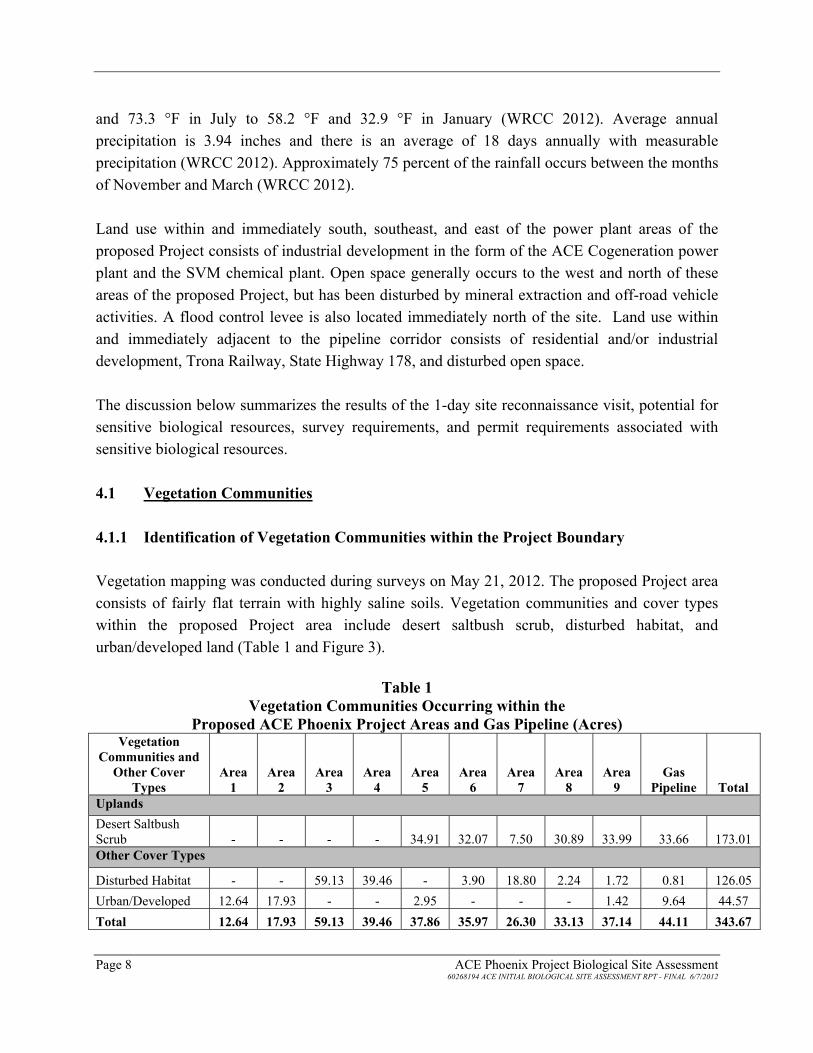
and 73.3 °F in July to 58.2 °F and 32.9 °F in January (WRCC 2012). Average annual precipitation is 3.94 inches and there is an average of 18 days annually with measurable precipitation (WRCC 2012). Approximately 75 percent of the rainfall occurs between the months of November and March (WRCC 2012). Land use within and immediately south, southeast, and east of the power plant areas of the proposed Project consists of industrial development in the form of the ACE Cogeneration power plant and the SVM chemical plant. Open space generally occurs to the west and north of these areas of the proposed Project, but has been disturbed by mineral extraction and off-road vehicle activities. A flood control levee is also located immediately north of the site. Land use within and immediately adjacent to the pipeline corridor consists of residential and/or industrial development, Trona Railway, State Highway 178, and disturbed open space. The discussion below summarizes the results of the 1-day site reconnaissance visit, potential for sensitive biological resources, survey requirements, and permit requirements associated with sensitive biological resources. ����� 9HJHWDWLRQ�&RPPXQLWLHV� ������� ,GHQWLILFDWLRQ�RI�9HJHWDWLRQ�&RPPXQLWLHV�ZLWKLQ�WKH�3URMHFW�%RXQGDU\� Vegetation mapping was conducted during surveys on May 21, 2012. The proposed Project area consists of fairly flat terrain with highly saline soils. Vegetation communities and cover types within the proposed Project area include desert saltbush scrub, disturbed habitat, and urban/developed land (Table 1 and Figure 3). �
7DEOH���9HJHWDWLRQ�&RPPXQLWLHV�2FFXUULQJ�ZLWKLQ�WKH��
3URSRVHG�$&(�3KRHQL[�3URMHFW�$UHDV�DQG�*DV�3LSHOLQH��$FUHV��9HJHWDWLRQ�
&RPPXQLWLHV�DQG�2WKHU�&RYHU�
7\SHV�$UHD���
$UHD���
$UHD���
$UHD���
$UHD���
$UHD���
$UHD���
$UHD���
�$UHD���
*DV�3LSHOLQH� 7RWDO�
8SODQGV Desert Saltbush Scrub - - - - 34.91 32.07 7.50 30.89 33.99 33.66 173.01 2WKHU�&RYHU�7\SHV�
Disturbed Habitat - - 59.13 39.46 - 3.90 18.80 2.24 1.72 0.81 126.05 Urban/Developed 12.64 17.93 - - 2.95 - - - 1.42 9.64 44.57 7RWDO� ������ ������ ������ ������ ������ ������ ������ ������ ������ ������ �������
ACE Phoenix Project Biological Site Assessment Page 9 60268194 ACE INITIAL BIOLOGICAL SITE ASSESSMENT RPT - FINAL 6/7/2012
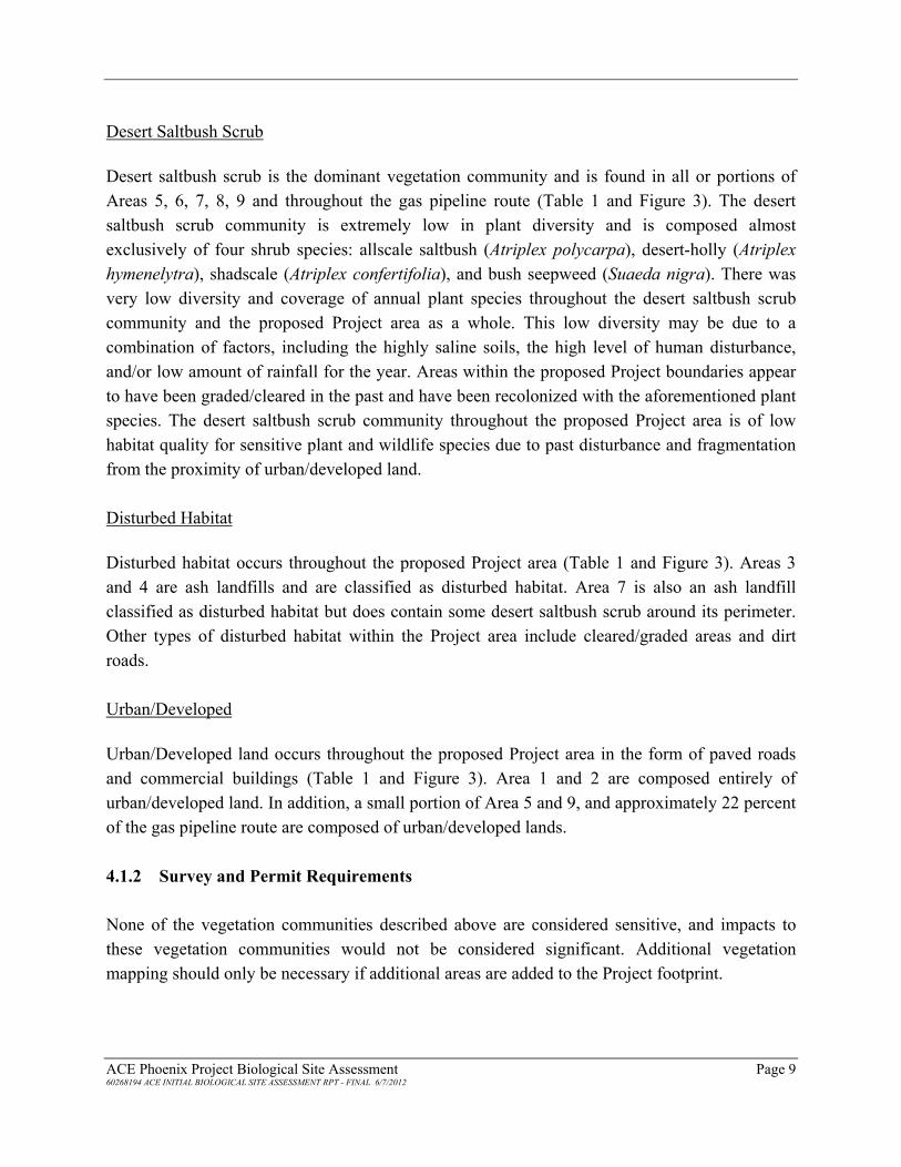
Desert Saltbush Scrub �Desert saltbush scrub is the dominant vegetation community and is found in all or portions of Areas 5, 6, 7, 8, 9 and throughout the gas pipeline route (Table 1 and Figure 3). The desert saltbush scrub community is extremely low in plant diversity and is composed almost exclusively of four shrub species: allscale saltbush (Atriplex polycarpa), desert-holly (Atriplex hymenelytra), shadscale (Atriplex confertifolia), and bush seepweed (Suaeda nigra). There was very low diversity and coverage of annual plant species throughout the desert saltbush scrub community and the proposed Project area as a whole. This low diversity may be due to a combination of factors, including the highly saline soils, the high level of human disturbance, and/or low amount of rainfall for the year. Areas within the proposed Project boundaries appear to have been graded/cleared in the past and have been recolonized with the aforementioned plant species. The desert saltbush scrub community throughout the proposed Project area is of low habitat quality for sensitive plant and wildlife species due to past disturbance and fragmentation from the proximity of urban/developed land. � Disturbed Habitat Disturbed habitat occurs throughout the proposed Project area (Table 1 and Figure 3). Areas 3 and 4 are ash landfills and are classified as disturbed habitat. Area 7 is also an ash landfill classified as disturbed habitat but does contain some desert saltbush scrub around its perimeter. Other types of disturbed habitat within the Project area include cleared/graded areas and dirt roads. Urban/Developed Urban/Developed land occurs throughout the proposed Project area in the form of paved roads and commercial buildings (Table 1 and Figure 3). Area 1 and 2 are composed entirely of urban/developed land. In addition, a small portion of Area 5 and 9, and approximately 22 percent of the gas pipeline route are composed of urban/developed lands. ������� 6XUYH\�DQG�3HUPLW�5HTXLUHPHQWV� None of the vegetation communities described above are considered sensitive, and impacts to these vegetation communities would not be considered significant. Additional vegetation mapping should only be necessary if additional areas are added to the Project footprint.

Page 10 ACE Phoenix Project Biological Site Assessment 60268194 ACE INITIAL BIOLOGICAL SITE ASSESSMENT RPT - FINAL 6/7/2012
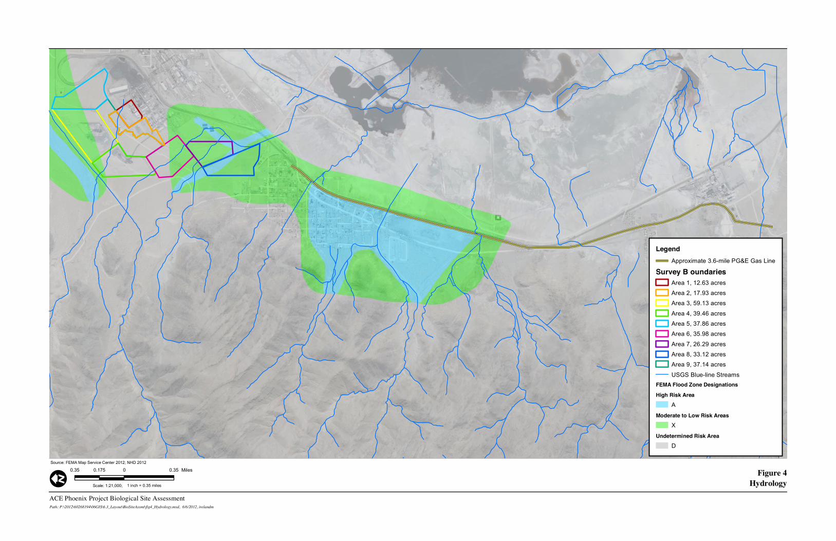
����� -XULVGLFWLRQDO�:DWHUV�DQG�+\GURORJLFDO�)HDWXUHV��A jurisdictional waters assessment was not performed as part of this initial site visit; however, a literature review of available information related to blue line streams and floodplain data was conducted to obtain contextual information relevant to the site. In addition, the biologists did look for indications of potentially jurisdictional waters that may be impacted by project activities during the initial site reconnaissance. Based on review of available mapping data (Figure 4), multiple blue line streams cross the Project area. Based on aerial imagery and site information, a flood control channel is located along the north side of the Project area that directs water around the facility. However, additional features cross the remainder of the areas proposed for potential solar fields, including Areas 4, 6, 7, and 8. Drainages were observed during the limited biological site assessment; however, no wash-dependent vegetation was detected within the drainages indicating potential unvegetated ephemeral dry washes and/or swale features. The potential exists that solar development within Areas 6, 7, and 8 may impact features that could be considered state or federally jurisdictional. In addition to the blue line streams, two Federal Emergency Management Act (FEMA) floodplain zones are within the proposed Project areas. Areas 3, 4, and 5 are partially within FEMA Flood Zone X; however, it is assumed (though not confirmed) that the flood control channel will redirect these flows around the site. In addition, Areas 3 and 4 are revegetated, elevated ash landfills. Zone X is the area subject to inundation during the 500-year storm event (i.e., a storm with a 0.2 percent chance of occurring in any year). The western half of Area 6 and all of Areas 7 and 8 are entirely within the FEMA Flood Zone X with a smaller portion of Area 7 and 8 in FEMA Flood Zone A (Area 7 contains a revegetated elevated ash landfill). Zone A is, by FEMA definition, an area subject to inundation during the 100-year storm event (i.e., a storm with a 1 percent chance of occurring in any year). Zone A is considered approximate because it is not based on detailed hydrologic or hydraulic analyses. As stated by FEMA, because detailed hydraulic analyses have not been performed and no Base Flood Elevations (BFEs) or flood depths are shown, mandatory flood insurance purchase requirements and floodplain management standards apply. In general, areas within Zone A require an elevation of 1 to 3 feet above existing grade to be permitted for building. A site-specific hydrology and hydraulics study would be needed to determine what current BFEs are on-site.
Page x-xxACE Phoenix Project Biological Site Assessment
6RXUFH��)(0$�0DS�6HUYLFH�&HQWHU�������1+'�����
6FDOH������������
Figure 4Hydrology
Path: P:\2012\60268194\06GIS\6.3_Layout\BioSiteAssmt\fig4_Hydrology.mxd, 6/6/2012, irelandm
���� � ��������� 0LOHV
Legend$SSUR[LPDWH�����PLOH�3*(�*DV�/LQH
Survey B oundaries$UHD����������DFUHV
$UHD����������DFUHV
$UHD����������DFUHV
$UHD����������DFUHV
$UHD����������DFUHV
$UHD����������DFUHV
$UHD����������DFUHV
$UHD����������DFUHV
$UHD����������DFUHV
86*6�%OXH�OLQH�6WUHDPVFEMA Flood Zone Designations
High Risk Area
$
Moderate to Low Risk Areas
;
Undetermined Risk Area
'
I ��LQFK� ������PLOHV

Page 12 ACE Phoenix Project Biological Site Assessment 60268194 ACE INITIAL BIOLOGICAL SITE ASSESSMENT RPT - FINAL 6/7/2012
This page intentionally left blank.
�

ACE Phoenix Project Biological Site Assessment Page 13 60268194 ACE INITIAL BIOLOGICAL SITE ASSESSMENT RPT - FINAL 6/7/2012
Additional analysis and mapping may be required to identify wetlands, streams/rivers, and topographic features and vegetative cover that may indicate the presence of aquatic features as well as flood hazards relevant to the Project area. Any aquatic features identified within the project boundary are unlikely to be considered waters of the U.S., but are likely to be considered waters of state pending further investigation and concurrence from the appropriate federal and state agencies (i.e., U.S. Army Corps of Engineers, U.S. Environmental Protection Agency, and California Department of Fish and Game [CDFG]). ������ 6SHFLDO�6WDWXV�6SHFLHV� For the purposes of this report, species are considered to have special-status if they meet at least one of the following criteria:
x Covered under the Federal and/or California Endangered Species Act (ESA); x Covered under the Bald and Golden Eagle Protection Act; x Covered under the Migratory Bird Treaty Act (MBTA); x Are CDFG sensitive species (CDFG 2012); x Are BLM sensitive species (BLM 2012); or x Covered under the Western Mojave Plan (BLM 2005).
As a result of a literature review including review of available prior reports; a CNDDB search (CDFG 2012); review of the CNPS online inventory and consortium of herbaria; and USFWS, American Bird Conservancy, and Audubon queries, six special-status plant and nine special-status wildlife species were evaluated for their potential to occur within the Project area (Areas 1-9 and pipeline route; Figure 5; Table 2). Following database review and the reconnaissance-level biological surveys, it was determined that the proposed Project has the potential for two special-status plant species and seven special-status wildlife species to occur on-site. Species evaluated but not expected to occur in the proposed Project area are not discussed in the text but are summarized in Table 2. ������� )ORUD��Special-Status Plant Species Occurrence �Clokey’s cryptantha is BLM sensitive and has a low potential to occur within the proposed Project area based on habitat type and quality. Similarly, Amargosa beardtongue is a CNPS list 1 species has a low potential to occur within the proposed Project area. More details on these

Page 14 ACE Phoenix Project Biological Site Assessment 60268194 ACE INITIAL BIOLOGICAL SITE ASSESSMENT RPT - FINAL 6/7/2012
species are provided in Table 2. Desert saltbush scrub habitat is present in Areas 5, 6, 7, 8, and 9 and along the pipeline corridor and has the potential to support these two species. General Survey and Permit Requirements Spring plant surveys would be needed to formally document presence or absence of the Clokey’s cryptantha and Amargosa beardtongue as well as their location within the Project area and or buffers, if present. In the Mojave Desert, the spring botanical season typically ranges from late February through May depending on rainfall and temperature. Sensitive plant species would require avoidance to the maximum extent practicable during construction. If present and complete avoidance is not possible, then seed salvage may be required to redistribute plants in adjacent areas or on mitigation sites. Specific recommendations for the ACE Phoenix Project are provided in Section 5.0. �������� )DXQD��Desert Tortoise (Gopherus agassizii) �Potential for Occurrence Desert tortoise (DT) has a very low potential to occur within the desert saltbush scrub habitat present in Areas 5, 6, 7, 8, and 9 and along the pipeline corridor (approximately 173 acres of suitable habitat). No potential habitat occurs within Areas 1, 2, 3, and 4. No DT sign or suitable burrows were found during the reconnaissance visit. The habitat on-site is low quality due to the minimal plant species present for DT foraging, and the habitat within the Project area provides little cover or shade for DT (Photo 1). Additionally, State Highway 178 is a barrier to DT habitat along the pipeline corridor. It’s unlikely that resident DT could persist on-site; however, DT could be present in higher quality habitat in the Argus Mountains located approximately 0.5 miles west, and transient DT could occasionally occur in the Project boundary. The closest documented DT occurrence is approximately 14 miles to the south of the Project area (CDFG 2012). During the site reconnaissance, DT exclusion fencing was observed around the ash landfill in Area 7 (Photo 2). General Survey and Permit Requirements Although the potential is low, DT protocol presence-or-absence surveys per the 1992 USFWS protocol may likely be required with 100 percent coverage within suitable habitat inside the project boundary, in addition to the five zone of influence transects outside of and parallel to the

Page x-xx
#
#
#
#
#
#
#
#
#
#
# ## ##
#
#
#
#
#
#
#
#
#
# #
#
## #
Inyo California Towhee
North Mojave Dry Lakes
pallid bat
long-eared owl
prairie falcon
prairie falcon
prairie falcon
Ripley's aliciella
Costa's hummingbird
Inyo California towheeInyo California towhee
Inyo California towhee
Inyo California towhee
Mohave ground squirrel
Inyo California towhee
Inyo California towheeInyo California towhee
Mohave ground squirrel
Mohave ground squirrel
Inyo California towhee
Mohave ground squirrel
Mohave ground squirrel
Mohave ground squirrel
Mohave ground squirrel
Inyo California towhee
Mohave ground squirrel
Townsend's big-eared bat
Booth's evening-primrose
Emory's crucifixion-thorn
western small-footed myotis
ACE Phoenix Project Biological Site Assessment
6RXUFH��')*�����
6FDOH������������
Figure 5Regional Database Records
Path: P:\2012\60268194\06GIS\6.3_Layout\BioSiteAssmt\fig5_RegDatabaseRecords.mxd, 6/6/2012, irelandm
����� � ���������� )HHW
LegendCNDDB Centroids
# 3ODQW# $QLPDO
��PLOH�&1''%�6HDUFK�%XIIHU
$SSUR[LPDWH�����PLOH�3*(�*DV�/LQH
&DOLIRUQLD�,PSRUWDQW�%LUG�$UHDV
Survey B oundaries$UHD����������DFUHV
$UHD����������DFUHV
$UHD����������DFUHV
$UHD����������DFUHV
$UHD����������DFUHV
$UHD����������DFUHV
$UHD����������DFUHV
$UHD����������DFUHV
$UHD����������DFUHV
I ��LQFK� �������IHHW

Page 16 ACE Phoenix Project Biological Site Assessment 60268194 ACE INITIAL BIOLOGICAL SITE ASSESSMENT RPT - FINAL 6/7/2012
This page intentionally left blank. ��

ACE Phoenix Project Biological Site Assessment Page 17 60268194 ACE INITIAL BIOLOGICAL SITE ASSESSMENT RPT - FINAL 6/7/2012
7DEOH���6SHFLDO�6WDWXV�3ODQW�DQG�$QLPDO�6SHFLHV�ZLWK�WKH�3RWHQWLDO�WR�2FFXU�
ZLWKLQ�WKH�9LFLQLW\�RI�WKH�3URSRVHG�3URMHFW�%RXQGDU\��
6SHFLHV 6WDWXV +DELWDW
3RWHQWLDO�IRU�2FFXUUHQFH�ZLWKLQ�
3URMHFW�$UHD *HQHUDO�6XUYH\�5HTXLUHPHQWV3ODQWV� Ripley’s aliciella (Aliciella ripleyi)
CNPS List: 2.3 Mojavean desert scrub, carbonate soils.
Not Expected None. No suitable habitat is present within the Project area for this species.
Darwin Mesa milk-vetch (Astragalus atratus var. mensanus)
BLM Sensitive CNPS List: 1B.1
Great Basin scrub, Joshua tree woodland, pinyon and juniper woodland on volcanic clay, gravelly soils.
Not Expected None. No suitable habitat is present within the Project area for this species.
Booth’s evening primrose (Eremothera boothii)
CNPS List: 2.3 Joshua tree woodland, pinyon and juniper woodland.
Not Expected None. No suitable habitat is present within the Project area for this species.
Emory’s crucifixion thorn (Castela emoryi)
CNPS List: 2.3 Mojavean desert scrub and playas.
Not Present None. This species is a large perennial shrub and would have been detected if present within the Project area during surveys.
Clokey’s cryptantha (Cryptantha clokeyi)
BLM Sensitive CNPS List: 1B.2
Mojavean desert scrub. Low Spring surveys – March–April
Amargosa beardtongue (Penstemon fruticiformis var. amargosae)
CNPS List: 1B.3 Mojavean desert scrub. Low Spring surveys – April–June
5HSWLOHV Desert tortoise (Gopherus agassizii; DT)
FT; ST; WEMO Various desert scrubs and desert washes up to about 5,000 feet, but not including playas.
Low Presence-or-absence surveys with 100% on-site coverage and buffer transects during April through May or September through October
%LUGV� Golden eagle (Aquila chrysaetos)
BGEPA; CDFG FP; WEMO
Open country, in prairies, tundra, open coniferous forest and barren areas, especially in hilly or mountainous regions, nesting on cliff ledges and in trees.
Low potential foraging habitat. No nesting habitat.
Aerial nest surveys within the project boundary and a 10-mile buffer between March and May, at least 30 days apart

Page 18 ACE Phoenix Project Biological Site Assessment 60268194 ACE INITIAL BIOLOGICAL SITE ASSESSMENT RPT - FINAL 6/7/2012
6SHFLHV 6WDWXV +DELWDW
3RWHQWLDO�IRU�2FFXUUHQFH�ZLWKLQ�
3URMHFW�$UHD *HQHUDO�6XUYH\�5HTXLUHPHQWVPrairie falcon (Falco mexicanus)
CDFG SSC; WEMO
Nests are located on cliffs in rugged mountain ranges, often within ½ mile of a water source. Forages in open habitat.
Low potential foraging habitat. No nesting habitat.
None
Inyo California towhee (I) �
FT, SE; WEMO Nests near riparian vegetation, including very small springs and seeps, and forages in mixed Mojave desert scrub. Ranges from 2,680 feet to 5,630 feet in elevation.
Not Expected. None.
Burrowing owl (Athene cunicularia)
BLM Sensitive; CDFG SSC; WEMO
Areas with low shrub cover with suitable burrowing opportunities
Low Minimum of four surveys to be conducted as part of the breeding season surveys; at least one site visit between February 15 and April 15 and a minimum of three survey visits, at least 3 weeks apart, between April 15 and July 15, with at least one visit after June 15.
0DPPDOV� Mohave ground squirrel (Spermophilus mohavensis)
ST; WEMO Mojave Desert shrub vegetation. High-quality habitat includes a diversity of shrub species, native herbaceous plants, and sandy or loamy soils that provide suitable substrate for burrow construction.
Moderate Four surveys with the first completed by the end of April. Each survey requires transects with live trapping.
Desert kit fox (Vulpes macrotis arsipus)
Calif. Code of Regulations: Protected Furbearing Mammal
This fossorial species is found in desert habitats of western states.
Low Surveys completed simultaneously with burrowing owl and desert tortoise surveys.

ACE Phoenix Project Biological Site Assessment Page 19 60268194 ACE INITIAL BIOLOGICAL SITE ASSESSMENT RPT - FINAL 6/7/2012
6SHFLHV 6WDWXV +DELWDW
3RWHQWLDO�IRU�2FFXUUHQFH�ZLWKLQ�
3URMHFW�$UHD *HQHUDO�6XUYH\�5HTXLUHPHQWVAmerican badger (Taxidea taxus)
CDFG SSC Coastal sage scrub, mixed chaparral, grassland, oak woodland, chamise chaparral, mixed conifer, pinyon-juniper, desert scrub, desert wash, montane meadow, open areas, and sandy soils.
Low Surveys completed simultaneously with burrowing owl and desert tortoise surveys.
Nelson’s bighorn sheep (Ovis canadensis nelsonii)
BLM Sensitive; WEMO
Mountain slopes with sparse growth of trees above the desert floor in California.
Not Expected to use site for forage or dispersal. Current development precludes dispersal corridor use.
None.
.H\��CNPS California Native Plant Society Lists: 1B: Considered rare, threatened, or endangered in California and elsewhere 2: Plants rare, threatened, or endangered in California, but more common elsewhere 3: Plants for which we need more information – review list
4: Plants of limited distribution a watch list Decimal notations: .1 - Seriously endangered in California, .2 – Fairly endangered in California, .3 – Not very endangered in California
FT = Federally Threatened SE = California State Endangered ST = California State Threatened BLM = Bureau of Land Management BGEPA = Bald and Golden Eagle Protection Act CDFG SSC = California Department of Fish and Game Species of Special Concern CDFG FP = California Department of Fish and Game Fully Protected WEMO = Western Mojave Plan Covered Species

Page 20 ACE Phoenix Project Biological Site Assessment 60268194 ACE INITIAL BIOLOGICAL SITE ASSESSMENT RPT - FINAL 6/7/2012
�3KRWR���±�9LHZ��ORRNLQJ�WR�WKH�VRXWKHDVW�IURP�WKH�ZHVW�FRUQHU�RI�$UHD����GHPRQVWUDWLQJ�WKH�ORZ�GLYHUVLW\�DQG�FRYHUDJH�ZLWKLQ�WKH�GHVHUW�VDOWEXVK�VFUXE�KDELWDW�SUHVHQW�RQ�VLWH���
3KRWR���±�'HVHUW�WRUWRLVH�H[FOXVLRQ�IHQFLQJ�SUHVHQW�DURXQG�WKH�DVK�ODQGILOO�LQ�$UHD����

ACE Phoenix Project Biological Site Assessment Page 21 60268194 ACE INITIAL BIOLOGICAL SITE ASSESSMENT RPT - FINAL 6/7/2012
project boundary at 100, 300, 600, 1,200, and 2,400 feet. The California Energy Commission (CEC) also requires additional survey transects at ¾ mile and 1 mile. DT protocol presence-or-absence surveys may occur during April through May or September through October. Specific survey recommendations for the ACE Phoenix Project are included in Section 5.0. If USFWS agrees that the habitat quality is poor and that the proposed Project is unlikely to adversely affect DT, then it may be possible to proceed with an informal consultation with the USFWS and obtain a concurrence letter rather than obtain take protection under the Federal ESA. If take protection is determined to be needed, the Project would need to conduct a formal consultation under either Section 7 or Section 10 of the Federal ESA. Assuming a federal nexus through the Prevention of Significant Deterioration air permit, a Section 7 Consultation with USFWS would be required to evaluate potential impacts to DT. As part of the Section 7 consultation, a Biological Assessment would be required in accordance with legal requirements set forth under Section 7(a)(2) of the Federal ESA (16 U.S. Code 1536[c]). If a federal nexus does not exist, a Section 10 process would be required including preparation of a Habitat Conservation Plan. If DT is present in areas associated with the proposed Project, the Project will need to obtain either a Section 2081 Incidental Take Permit (ITP) for DT or a CDFG concurrence under the California ESA Section 2080.1 with the federal take authorization issued by USFWS for DT under the Federal ESA. Should the agencies determine that the habitat is considered suitable for DT, take permits will need to be obtained and compensatory mitigation will likely be required. In addition to presence-or-absence surveys, DT clearance surveys would be required during April through May or September through October prior to construction. Golden Eagle (Aquila chrysaetos) �Potential for Occurrence No nesting habitat for the golden eagle (GOEA) occurs within the proposed Project area, but suitable nesting habitat may occur within the Argus and Slate Mountain Ranges (located approximately 0.5 mile west of the Project and 9.5 miles east of the Project, respectively), and eagles are known to forage over large areas, e.g., up to 10 miles from their nests. The desert saltbush scrub habitat present in Areas 5, 6, 7, 8, and 9 and along the pipeline corridor provides suitable foraging habitat for GOEA (approximately 173 acres of suitable foraging habitat). No potential foraging habitat occurs within Areas 1, 2, 3, and 4. GOEA prey, such as black-tailed jackrabbit (Lepus californicus), were noted as present within the desert saltbush scrub habitat during the reconnaissance visit. However, the activity around the industrial plants and off-road

Page 22 ACE Phoenix Project Biological Site Assessment 60268194 ACE INITIAL BIOLOGICAL SITE ASSESSMENT RPT - FINAL 6/7/2012
vehicle activity immediately adjacent to foraging habitat are likely to discourage GOEA from foraging extensively within the proposed Project boundary, and potential use of the site is considered low. General Survey and Permit Requirements Surveys for GOEA at solar energy facilities are a relatively new requirement that is still evolving. Per the USFWS Interim Golden Eagle Inventory and Monitoring Protocols; and other Recommendations (Pagel et al. 2010), two aerial flights of the project boundary and a 10-mile radius are typically required between March and May, at least 30 days apart, to assess GOEA presence. An eagle take permit would not be required, but the proposed Project may need to address any potential impact to GOEA foraging habitat. Specific survey recommendations for the ACE Phoenix Project are included in Section 5.0.��Prairie Falcon (Falco mexicanus) Potential for Occurrence No nesting habitat occurs within the proposed Project area, but suitable nesting habitat may occur within the Argus and State Mountain Ranges, and prairie falcons are known to forage over large areas. The nearest known location where prairie falcon was observed is approximately 3 miles north of the proposed Project (CDFG 2012). The desert saltbush scrub habitat present in Areas 5, 6, 7, 8, and 9 and along the pipeline corridor provides suitable foraging habitat (approximately 173 acres of suitable foraging habitat). No potential foraging habitat occurs within Areas 1, 2, 3, and 4. Small mammal presence was confirmed by active small burrows present within the desert saltbush scrub habitat during the reconnaissance visit. These small mammals could provide prey for prairie falcons. However, the activity around the industrial plants and off-road vehicle activity immediately adjacent to foraging habitat likely discourage prairie falcons from foraging within the Project boundary, and potential use of the site is considered low. General Survey and Permit Requirements No species-specific surveys are required for prairie falcon. �

ACE Phoenix Project Biological Site Assessment Page 23 60268194 ACE INITIAL BIOLOGICAL SITE ASSESSMENT RPT - FINAL 6/7/2012
Burrowing Owl (Athene cunicularia) Potential for Occurrence Burrowing owl (BUOW) has a low potential to occur within the desert saltbush scrub habitat present in Areas 5, 6, 7, 8, and 9 and along the pipeline corridor (approximately 173 acres of suitable habitat) due to the low quality habitat and surrounding industrial activities. No potential habitat occurs within Areas 1, 2, 3, and 4. No BUOW sign or suitable burrows were found during the reconnaissance visit. The nearest known locations are approximately 15 miles southwest and southeast of the proposed Project (CDFG 2012). General Survey and Permit Requirements The current guidelines applicable to the BUOW include the CDFG Staff Report for BUOW which was issued on March 7, 2012, and requires a minimum of four surveys to be conducted as part of the breeding season surveys ([1] at least one site visit between February 15and April 15 and [2] a minimum of three survey visits, at least 3 weeks apart, between April 15 and July 15, with at least one visit after June 15). If BUOW are detected, CDFG would require mitigation based on impacts to individuals, suitable foraging habitat, and occupied burrows. Mohave Ground Squirrel (Spermophilus mohavensis) Potential for Occurrence Mohave ground squirrel (MGS) have historically been observed in the region with six records identified in the CNDDB within a 5-mile radius of the site. One MGS record (1989) occurs within the Project area (Area 3), where an adult male was observed during construction of the ACE Cogeneration facility. There is the potential for MGS to be present within Areas 5, 6, 7, 8, 9 and portions of the pipeline route; however, because the habitat on-site is of low quality, the potential for resident or transient MGS to be present on-site is considered low. Given the potential for this species to be present, MGS expert Dr. Phil Leitner has been consulted regarding an MGS Habitat Assessment. A separate report summarizing his MGS Habitat Assessment is included as Appendix B. General Survey and Permit Requirements A MGS survey effort consists of four surveys with multiple transects with live trapping. The survey effort is intensive and expensive. In addition, the survey effort can confirm presence;

Page 24 ACE Phoenix Project Biological Site Assessment 60268194 ACE INITIAL BIOLOGICAL SITE ASSESSMENT RPT - FINAL 6/7/2012
however, CDFG often does not make a determination of absence if surveys do not result in trapping of the species. Alternatively, the Project can assume presence and mitigate for impacts to potential habitat. The latter would require obtaining an ITP via a Section 2081 process with CDFG (similar to the DT). A summary of specific survey recommendation for the ACE Phoenix Project is included in Section 5.0. Desert Kit Fox (Vulpes macrotis arsipus) Potential for Occurrence Desert kit fox has a low potential to occur within the desert saltbush scrub habitat present in Areas 5, 6, 7, 8, and 9 and along the pipeline corridor (approximately 173 acres of suitable habitat). No potential habitat occurs within Areas 1, 2, 3, and 4. No desert kit fox sign or suitable burrows were found in any of the areas during the reconnaissance visit. Although active small mammal burrows, found within all areas, indicate a prey base is present for this species, the potential for kit fox to occur on-site is low due to the low amount of vegetation cover and high site disturbance. Kit fox are known to occur approximately 10 miles to the west at the Naval Air Weapons Station China Lake. General Survey and Permit Requirements Kit fox sign and suitable burrows would be recorded while conducting DT surveys. If found, the agencies would likely require the avoidance of occupied dens to the maximum extent practicable during construction. Should impacts to occupied dens be unavoidable, a typical mitigation measure requires that kit fox be passively excluded from occupied dens and the dens collapsed using agreed-upon methodologies. Specific survey recommendations for the ACE Phoenix Project are included in Section 5.0. American Badger (Taxidea taxus) Potential for Occurrence American badger has a low potential to occur within the desert saltbush scrub habitat present in Areas 5, 6, 7, 8, and 9 and along the portion of the pipeline corridor with suitable habitat. No potential habitat occurs within Areas 1, 2, 3, and 4. No American badger sign or suitable burrows were found in any of the areas during the reconnaissance visit. Although active small mammal burrows indicate a prey base is present for this species, the potential for American badger to occur on-site is low due to the low amount of vegetation cover and high site disturbance.
ACE Phoenix Project Biological Site Assessment Page 25 60268194 ACE INITIAL BIOLOGICAL SITE ASSESSMENT RPT - FINAL 6/7/2012
General Survey and Permit Requirements American badger sign and suitable burrows would be recorded while conducting DT surveys. If found, the agencies would likely require the avoidance of occupied dens to the maximum extent practicable during construction. Should impacts to occupied dens be unavoidable, a typical mitigation measure requires that American badger be passively excluded from occupied dens and the dens collapsed using agreed-upon methodologies. Specific survey recommendations for the ACE Phoenix Project are included in Section 5.0. Migratory Birds Potential for Occurrence The Project area contains suitable habitat for species of migratory birds. Additionally, the site is located within an avian migration corridor. Although a dry lake, Searles Lake, located approximately 1.5 miles east of the Project, is designated as an Audubon State Important Bird Area (IBA) and is part of the North Mojave Dry Lakes IBA (Audubon 2012), located less than 1 mile east-southeast from the Project area. This IBA refers to four large dry lakes and associated seasonal wetlands between Ridgecrest and Barstow in the northern Mojave Desert: China Lake, Searles Dry Lake, Koehn Dry Lake, and Harper Dry Lake (Audubon 2012). Thousands of waterbirds stop over at these lakes during migration (Audubon 2012). Although no wetlands occur on-site, and the site is located near the mountains with the town of Trona and industrial facilities located between the site and Searles Lake, the USFWS may be concerned with potential Project features such as evaporation ponds and solar mirrors may inadvertently attract waterbirds to the site and/or interfere with migratory patterns. General Survey and Permit Requirements Interim Guidelines for the Development of a Project-Specific Bird and Bat Protection Plan for Solar Energy Plant and Related Transmission Facilities (USFWS 2010) provides energy project developers with a tool for assessing the risk of potential impacts, and designing and operating a bird- and bat-friendly solar facility. While these guidelines are voluntary, conforming to these guidelines is suggested by USFWS in order to avoid, minimize, and mitigate impacts to special-status species and species protected under the MBTA. These guidelines recommend various preconstruction surveys including, but not limited to, at least 1 year of avian point count surveys. Data gathered during surveys are used to produce an Avian and Bat Protection Plan. This

Page 26 ACE Phoenix Project Biological Site Assessment 60268194 ACE INITIAL BIOLOGICAL SITE ASSESSMENT RPT - FINAL 6/7/2012
document provides assurance to USFWS that the Project will avoid and minimize impacts to bird and bat populations. In accordance with the MBTA, if vegetation removal is scheduled to take place during the breeding season (roughly February through June for most species in the desert), nest clearance surveys would be required to avoid impacts to nesting birds. In addition, measures that reduce impacts to avian species during plant operation will likely be required.
����� 6800$5<�$1'�5(&200(1'$7,216� The Project design and layout are under ongoing development and refinement; however, several of the areas currently proposed for potential solar development do contain native habitat. Although the native habitat is generally considered to be of low quality, it does have the potential to support special-status species as summarized in Section 4.0 above. Based on the limited site assessment and this initial review of potential biological resources for the Project area, initial recommendations have been developed and are provided per resource in Table 3 below.
7DEOH���6XUYH\�DQG�3HUPLW�5HFRPPHQGDWLRQV�IRU�.H\�%LRORJLFDO�5HVRXUFHV�
�
6SHFLHV
3RWHQWLDO�IRU�
2FFXUUHQFH
$UHDV�ZLWK�
3RWHQWLDO�+DELWDW�� 5HFRPPHQGDWLRQ
3ODQWV Clokey’s cryptantha
Low 5, 6, 7, 8, 9, Pipeline
Though the potential for this species is considered low, spring rare plant surveys are necessary to confirm presence/absence and the location of plants within the Project area and buffers. Surveys are proposed for spring 2013 to confirm status. Surveys would be targeted for April to catch the preferred period for both species.
Amargosa beardtongue
Low 5, 6, 7, 8, 9, Pipeline
Though the potential for this species is considered low, spring rare plant surveys are necessary to confirm presence/absence and the location of plants within the Project area and buffers. Surveys are proposed for spring 2013 to confirm status. Surveys would be targeted for April to catch the preferred period for both species.
5HSWLOHV Desert tortoise
Low 5, 6, 7, 8, 9, Pipeline
Given the conditions on-site, the potential for resident DT is considered very low and no DT have been recorded within 14 miles of the site; however, given the connectivity to creosote habitat off-site toward the Argus Mountains, there is a low

ACE Phoenix Project Biological Site Assessment Page 27 60268194 ACE INITIAL BIOLOGICAL SITE ASSESSMENT RPT - FINAL 6/7/2012
6SHFLHV
3RWHQWLDO�IRU�
2FFXUUHQFH
$UHDV�ZLWK�
3RWHQWLDO�+DELWDW�� 5HFRPPHQGDWLRQ
potential for transients that cannot be ruled out. The Applicant is proposing to conduct surveys in September/October 2012 to confirm presence/absence of DT.
%LUGV� Golden eagle
Low potential foraging habitat. No nesting habitat.
N/A Although there is native habitat that does support some unquantified prey base for the GOEA, the Project area is not ideal foraging habitat given the amount of disturbance and development. There is no nesting habitat within 1-mile of the site. Given the lack of nesting habitat and the poor conditions of the area to support foraging habitat, GOEA surveys are not proposed. USFWS will be consulted regarding the proposed approach. USFWS will also be consulted on existing data regarding GOEA nests within 10 miles of the site (i.e., within the Argus or Slate Mountains). A formal FOIA (Freedom of Information Act) may be required to obtain any data.
Burrowing owl
Low 5, 6, 7, 8, 9, Pipeline
No BUOW burrows or sign were detected during the limited site reconnaissance. Given the low potential for occurrence, presence/absence surveys are not proposed; however, BUOW burrows and sign would be assessed during DT presence/absence surveys. The DT surveys would therefore provide additional information on the presence/absence of BUOW in the Project area. The project would also implement preconstruction clearance surveys and would implement appropriate management measures based on the results of those surveys. Mitigation would be based upon detection during preconstruction clearance surveys, if any, and the need to passively relocate any owls detected within the area of disturbance.
Migratory Bird Treaty Act
N/A N/A The Project area is near the North Mojave Dry Lakes Important Bird Area as well as within an avian migration corridor. Therefore, avian surveys are proposed to establish a baseline condition for the Project area regarding bird use. Baseline surveys will include point counts required over one year, four seasons, to establish annual use patterns. Design of the bird surveys will involve negotiation with the resource agencies to confirm expected level of effort and to obtain approval of a proposed monitoring program and management plan. These surveys are proposed to start during the summer season after preparation and approval of a monitoring program.

Page 28 ACE Phoenix Project Biological Site Assessment 60268194 ACE INITIAL BIOLOGICAL SITE ASSESSMENT RPT - FINAL 6/7/2012
6SHFLHV
3RWHQWLDO�IRU�
2FFXUUHQFH
$UHDV�ZLWK�
3RWHQWLDO�+DELWDW�� 5HFRPPHQGDWLRQ
0DPPDOV� Mohave ground squirrel
Moderate 5, 6, 7, 8, 9, Pipeline
There are two options for addressing MGS. One is to assume presence and proceed with an ITP for MGS with California and implement required compensatory mitigation. The other is to conduct protocol surveys (consisting of live trapping). The results of the surveys would be good for 1 year. If no MGS are trapped, it is assumed that an ITP and compensatory mitigation would not be required. Given the potential for MGS to be present onsite and the historical records in the area, the Applicant may assume presence and not complete MGS surveys. If presence is assumed, mitigation for impacts to MGS habitat is proposed to be at a 3:1 ratio (mitigation to impact), given the current disturbed and developed nature of lands associated with the project and in the vicinity.
Desert kit fox
Low 5, 6, 7, 8, 9, Pipeline
The species was not detected, but presence/absence cannot be verified without surveys. Given the low probability of presence, separate surveys are not proposed. Surveys will be completed simultaneously with DT surveys to check for sign. Desert kit fox does not require compensatory mitigation but would require passive relocation should it be detected. If detected and passive relocation is required, the Project applicant will prepare a Kit Fox Monitoring and Management Plan.
American badger
Low 5, 6, 7, 8, 9, Pipeline
The species was not detected, but presence/absence cannot be verified without surveys. Given the low probability of presence, separate surveys are not proposed. Surveys will be completed simultaneously with DT surveys to check for sign. This species does not require compensatory mitigation, but would require passive relocation should it be detected. If detected and passive relocation is required, the Project applicant will prepare an American Badger Monitoring and Management Plan.
1 If required, surveys would only be conducted within potential habitat. Surveys would also include appropriate buffer surveys in accordance with agency requirements.
������ /,7(5$785(�&,7('� Audubon. 2012. Important Bird Areas Program. Available at http://iba.audubon.org/iba/viewSite
Profile.do?siteId=212&navSite=state. Accessed May 2012. Bureau of Land Management (BLM). 2005. Final Environmental Impact Report and Statement
for the West Mojave Plan A Habitat Conservation Plan and California Desert
ACE Phoenix Project Biological Site Assessment Page 29 60268194 ACE INITIAL BIOLOGICAL SITE ASSESSMENT RPT - FINAL 6/7/2012
Conservation Area Plan Amendment Vol 1. Available at http://www.blm.gov/ca/pdfs/ cdd_pdfs/wemo_pdfs/plan/wemo/Vol-1-Chapter1_Bookmarks.pdf. Accessed May 2012.
Bureau of Land Management (BLM). 2012. California BLM Special-status Plants and Animals
Plants available at http://www.blm.gov/pgdata/etc/medialib/blm/ca/pdf/pa/botany.Par. 25833.File.dat/All%20CA%20Plants%20Detailed%20Report-12-17-2010.pdf. Animals available at: http://www.blm.gov/pgdata/etc/medialib/blm/ca/pdf/pa/wildlife.Par.13499. File.dat/BLM%20Sensitive%20Animal%20Update%20SEP2006.pdf.
California Department of Fish and Game (CDFG). 2012. RareFind Version 3.1.1. California
Department of Fish and Game Natural Diversity Database (CNDDB). CDFG. Sacramento, California. Commercial Version.
CDFG. 2012. Staff Report on Burrowing Owl Mitigation. March 7. McCormick Biological Inc. 2012. Initial Site Biological Evaluation ACE Cogeneration Facility
Expansion Project. April. Pagel, J. E., D. M. Whittington, and G. T. Allen. 2010. Interim Golden Eagle Inventory and
Monitoring Protocols; and Other Recommendations. Division of Migratory Bird Management, U.S. Fish and Wildlife Service. February.
Western Regional Climate Center (WRCC) 2012. Period of Record Monthly Climate Summary
from 1/1/1920 to 4/30/2012. Available at http://www.wrcc.dri.edu/cgi-bin/cliMAIN.pl?ca9035. Accessed May 2012.
U.S. Fish and Wildlife Service (USFWS). 1992. Field Survey Protocol for Any Federal Action
That May Occur within the Range of the Desert Tortoise. January. USFWS. 2010. Interim Guidelines for the Development of a Project-Specific Bird and Bat
Protection Plan for Solar Energy Plant and Related Transmission Facilities. September 2.

Page 30 ACE Phoenix Project Biological Site Assessment 60268194 ACE INITIAL BIOLOGICAL SITE ASSESSMENT RPT - FINAL 6/7/2012
This page intentionally left blank.

������������
$33(1',;�$�%27$1,&$/�$1'�:,/'/,)(�63(&,(6�2%6(59('�


7DEOH�$���3ODQW�6SHFLHV�/LVW�
�)DPLO\� 6FLHQWLILF�1DPH� &RPPRQ�1DPH�
Asteraceae Geraea canescens desert-sunflower Chenopodiaceae Atriplex confertifolia shadscale Chenopodiaceae Atriplex covillei Coville's orach Chenopodiaceae Atriplex hymenelytra desert-holly Chenopodiaceae Atriplex polycarpa allscale saltbush Chenopodiaceae Suaeda nigra bush seepweed Onagraceae Camissonia spp. San Benito evening-primrose Poaceae Schismus arabicus Arabian schismus Tamaricaceae Tamarix aphylla athel Tamaricaceae Tamarix ramosissima saltcedar Zygophyllaceae Larrea tridentata creosote
����
7DEOH�$���:LOGOLIH�6SHFLHV�/LVW�
�)DPLO\� 6FLHQWLILF�1DPH� &RPPRQ�1DPH�
Corvidae Corvus corax common raven Columbidae Streptopelia decaocto Eurasian collared dove Accipitridae Buteo jamaicensis red-tailed hawk Leporidae Lepus californicus black-tailed jackrabbit Leporidae Sylvilagus audubonii desert cottontail Heteromyidae Dipodymys sp. kangaroo rat Sciuridae -- Unidentified ground squirrel species Phrynosomatidae Uta stansburiana side-blotched lizard


�������
$33(1',;�%��
0*6�+$%,7$7�$66(660(17�

��

����
ACE�Phoenix�Project�Trona,�California�
�
MOHAVE�GROUND�SQUIRREL�HABITAT�ASSESSMENT�
Prepared�by��
Philip�Leitner�2�Parkway�Court�Orinda,�CA�94563�
[email protected]�(925)�253Ͳ8400�Office�(925)�899Ͳ4948�Mobile�
�Prepared�for�
�AECOM�Environment�1220�Avenida�Acaso�Camarillo,�CA�93012�
�May�31,�2012�
��
������������

INTRODUCTION��The�ACE�Phoenix�Project�in�Trona�will�consist�of�three�components.��The�first�is�the�installation�of�two�new�gasͲfired�turbines�at�the�site�of�the�existing�cogeneration�facility.��A�natural�gas�pipeline�is�proposed�to�provide�fuel�for�the�turbines.��It�will�run�parallel�to�SR�178�for�approximately�3.5�miles�north�from�an�existing�pressure�valve�station�to�the�vicinity�of�the�cogeneration�facility.��The�third�component�of�the�project�proposes�the�installation�of�a�solar�field�in�several�areas�adjacent�to�or�south�of�the�existing�cogeneration�facility.��I�visited�the�project�site�on�May�20,�2012�in�order�to�evaluate�habitat�conditions�and�to�assess�its�suitability�as�habitat�for�the�stateͲlisted�Mohave�ground�squirrel�(Xerospermophilus�mohavensis).��I�was�able�to�observe�habitat�conditions�in�all�parts�of�the�project�site�except�for�Areas�3�and�4,�which�are�fenced�and�surrounded�by�tall�berms.��Areas�3�and�4�are�ash�disposal�sites�and�do�not�support�natural�desert�habitat.��The�site�of�the�cogeneration�facility�is�directly�bordered�to�the�north�and�west�by�relatively�intact�desert�scrub�habitat.��There�are�a�number�of�Mohave�ground�squirrel�(MGS)�occurrence�records�within�5Ͳ6�miles�of�the�project�site�in�habitat�similar�to�that�near�the�cogeneration�facility�and�along�the�pipeline�route.����HABITAT�ASSESSMENT��Relatively�intact�desert�scrub�habitat�borders�the�main�project�site�to�the�west�and�north.��Segments�of�the�proposed�pipeline�route�pass�through�desert�scrub�habitat.��There�are�MGS�occurrence�records�in�similar�habitat�within�the�region,�so�these�areas�adjacent�to�the�main�project�site�and�pipeline�could�support�MGS�populations.��As�a�result,�there�is�the�potential�that�transient�or�resident�MGS�may�be�present�on�land�within�the�proposed�project�boundaries�that�supports�desert�scrub�vegetation.����Area�1� � ��This�area�has�been�completely�developed�for�industrial�use�and�has�been�cleared�of�natural�desert�habitat.��It�is�not�suitable�for�occupancy�by�the�MGS.���Area�2��This�area�has�been�partially�cleared�and�developed�with�project�facilities�including�large�storage�tanks.��However,�approximately�2/3�of�this�area�still�supports�desert�scrub�vegetation,�primarily�two�species�of�saltbush�(Atriplex).��This�portion�of�Area�2�is�suitable�habitat�for�the�MGS.��Area�3��This�area�has�been�used�for�ash�disposal�and�does�not�support�natural�desert�habitat.�It�is�not�suitable�for�occupancy�by�the�MGS.����

Area�4��This�area�has�been�used�for�ash�disposal�and�does�not�support�natural�desert�habitat.�It�is�not�suitable�for�occupancy�by�the�MGS.�����Area�5��This�area�has�been�previously�disturbed,�but�supports�low�density�desert�scrub�habitat.��It�is�dominated�by�saltbush�(Atriplex)�species�and�small�mammal�burrows�are�present.��It�is�suitable�for�occupancy�by�the�MGS.�����������Area�6��This�area�supports�natural�desert�habitat�consisting�mainly�of�saltbush�(Atriplex)�species�plus�some�creosote�bush�(Larrea�tridentata).��It�is�directly�connected�to�larger�areas�of�desert�scrub�habitat�to�the�west.��It�is�suitable�for�occupancy�by�the�MGS.������Area�7��This�area�has�been�used�for�ash�disposal�and�is�almost�completely�devoid�of�natural�desert�vegetation.��The�small�amount�of�saltbush�(Atriplex)�scrub�along�the�northern�and�western�edges�of�this�area�is�not�suitable�for�occupancy�by�the�MGS.�����Area�8��This�area�supports�natural�desert�habitat�consisting�mainly�of�saltbush�(Atriplex)�species.��It�is�directly�connected�to�larger�areas�of�desert�scrub�habitat�to�the�north�and�west.��It�is�suitable�for�occupancy�by�the�MGS.���Pipeline�Route��The�northernmost�segment�of�the�pipeline�route�runs�for�about�0.75�mi�through�the�community�of�Argus,�a�residential�area�with�some�commercial�businesses�near�SR�178.��There�is�no�potential�MGS�habitat�here.��To�the�south�of�Argus,�the�pipeline�route�runs�for�about�0.9�mi�through�natural�habitat�between�the�railroad�and�SR�178.��This�segment�of�the�route�passes�through�suitable�habitat�for�the�MGS.��After�crossing�SR�178,�the�pipeline�route�parallels�the�highway�to�the�west.��It�passes�through�about�0.5�mi�of�sparse�native�desert�vegetation.��This�habitat�is�suitable�for�MGS�but�is�of�relatively�low�quality.��

Beyond�this�segment,�the�pipeline�route�continues�to�parallel�SR�178�to�the�west.��It�passes�through�about�0.6�mi�of�highly�disturbed�lands�and�finally�runs�through�a�trailer�park.��There�is�no�suitable�habitat�in�this�portion�of�the�route.��South�of�the�trailer�park,�the�route�passes�through�about�0.3�mi�of�habitat�that�is�suitable�for�MGS�but�of�relatively�low�quality.��It�then�continues�south�still�to�the�west�of�SR�178,�crossing�rocky�hills�and�a�large�disposal�site.��This�segment�is�about�0.3�mi�in�length�and�does�not�include�any�suitable�habitat.��The�final�segment�of�the�pipeline�route�passes�through�about�0.2�mi�of�desert�scrub�habitat�that�is�suitable�for�the�MGS.��RECOMMENDATION��It�is�recommended�that�those�portions�of�the�project�site,�including�the�pipeline�route,�that�support�suitable�MGS�habitat�be�surveyed�for�the�presence�of�the�species.��The�standard�protocol�survey�must�be�carried�out�in�the�spring�and�early�summer,�when�the�species�is�active�aboveͲground.��If�the�surveys�fail�to�demonstrate�the�presence�of�the�species,�this�result�is�considered�valid�for�one�year.���