6. MoveMent & transport - County Kildare · 6 126 Kildare County Development Plan 2017-2023 127 6....
15
6. MOVEMENT & TRANSPORT AIM To promote ease of movement within and access to County Kildare, by integrating sustainable land use planning with a high quality integrated transport system; to support improvements to the road, rail and public transport network, together with cycleway and pedestrian facilities and to provide for the sustainable development of aviation travel within the county in a manner which is consistent with the proper planning and sustainable development of the county. 126 127
Transcript of 6. MoveMent & transport - County Kildare · 6 126 Kildare County Development Plan 2017-2023 127 6....

6
126 Kildare County Development Plan 2017-2023 Kildare County Development Plan 2017-2023 127
6. MoveMent & transport
AIM
To promote ease of movement within and access to County Kildare, by integrating sustainable land use planning with a high quality integrated transport system; to support improvements to the road, rail and public transport network, together with cycleway and pedestrian facilities and to provide for the sustainable development of aviation travel within the county in a manner which is consistent with the proper planning and sustainable development of the county.
126 127

6
128 Kildare County Development Plan 2017-2023 Kildare County Development Plan 2017-2023 129
(a) Influenced by the type of place in which the street is located, and
(b) Balance the needs of all users.
6.2.3 National Cycle Policy Framework 2009-2020
The National Cycle Policy Framework (as part of Smarter Travel – A Sustainable Transport Future) (2009) sets out a national policy for cycling, in order to create a stronger cycling culture, a more friendly environment for cycling and improved quality of life. The vision is that all cities, towns and rural areas will be bicycle friendly. The policy document sets a target of 10% of all commuter trips by bicycle by 2020 and places emphasis on promoting and integrating cycle networks.
6.2.4 Transport Strategy for the Greater Dublin Area,
NTA 2016-2035
This strategy provides a framework for the planning and delivery of transport infrastructure and services in the Greater Dublin Area (GDA) over the next two decades. It also provides a transport planning policy around which other agencies involved in land use planning, environmental protection, and delivery of other infrastructure such as housing, water and power, can align their investment priorities.
6.2.5 Spatial Planning and National Road Guidelines for Planning Authorities, DECLG (2012)
The DECLG issued these guidelines in 2012 following consultation with representatives from local authorities, the DTTS and the NRA, to assist road and planning authorities. These guidelines set out planning policy considerations relating to development affecting national primary and secondary roads, including motorways and associated junctions, outside the 50-60km/h speed limit zones for cities, towns and villages. These guidelines encourage a collaborative approach between planning authorities and TII in ensuring that Ireland’s national roads system is planned for and managed in an integrated manner enabling economic development while encouraging a shift towards more sustainable travel and transport in accordance with the Government’s overarching transport policy objectives set out in Smarter Travel: A New Transport Policy for Ireland 2009 - 2020.
6.2.6 Rural Transport Initiative
Rural Transport Initiatives are supported by the DTTS under the Rural Transport Programme and part financed by the EU through the National Development Plan. There are currently two companies offering a rural transport service within the county.
6.3 MoveMent and transportation
The social, economic and environmental wellbeing of County Kildare and the GDA is dependent on the efficient and sustainable movement of people and goods within and through the county. This can be achieved by providing a range of transport options that are safe, convenient, reliable and offer value for money.
The Council recognises its role in working with the relevant transport agencies to seek to ensure that as high a proportion as possible of trips are conducted by sustainable means.
The Council also recognises that a large proportion of trips will continue to be served by private vehicles and that provision will need to be made for new road infrastructure and for improvements to the existing network.
The Council is committed to supporting:
−− Sustainable forms of transport such as public transport, walking and cycling;
−− The development of new road infrastructure that provides access to new communities and economic development areas; and
−− Improvements to the national, regional and local road network.
Policies: Movement and TransportIt is the policy of the Council to:
MT 1 Promote the sustainable development of the county through the creation of an appropriately phased integrated transport network that services the needs of communities and businesses.
MT 2 Support sustainable modes of transport by spatially arranging activities around existing and planned high quality public transport systems.
6.1 introduction
The transportation system caters for the movement of communities and businesses. National and regional transport policy recognises that current transport trends in Ireland and the GDA, in particular levels of car use, are unsustainable and that a transition towards more sustainable modes of transport, such as walking, cycling and public transport is required. Kildare County Council recognises its important role as a local authority in increasing accessibility, promoting active travel modes and seeking to reduce car use by a variety of means and to better integrate land use and transportation planning at a county level. The Council will proactively engage with the National Transport Authority and other relevant transport agencies in seeking to achieve the above sustainable transport aim.
Kildare has a widespread transport network with many of the main transportation corridors linking Dublin to the rest of the country passing through County Kildare. The M4 runs east-west along the northern boundary of the county, the M7 runs diagonally on the northeast-southwest axis through the centre of the county and the M9 runs southwards to Castledermot, Carlow and onwards.
There are also four mainline railway passenger services traversing the county, the Sligo, Cork/ Limerick, Galway and Waterford lines and two suburban services linking Kildare to Heuston Station and Maynooth to Connolly Station.
Many residents of Kildare commute for employment. While 60% of those in employment have jobs within the county, over 40% travel outside of the county to their job. There is a significant level of commuting into the north-eastern part of the county where there is a concentration of major employers. Dublin is the dominant employment destination with over 72% of outward Kildare commuters working in Dublin City Centre, South Dublin, Fingal, Dun Laoghaire Rathdown and Meath. Other commuting routes include connections to adjacent towns such as Carlow and Portlaoise in the south of the county.
Commuting patterns in Kildare rely heavily on private car transport:
−− 66% of commuters use private car transport.
−− 18% of commuters use bus and/or rail for their daily commute.
−− 16% of commuters walk or cycle to work, school or college. This latter figure is well below the regional average of 22%.
It is clear that if current trends in the region in relation to vehicular traffic continue, congestion will increase, transport emissions will grow, economic competitiveness will suffer and quality of life within Kildare will decline.
A major challenge facing Kildare during the lifetime of this Plan and beyond is the need to promote and provide for sustainable transportation options whilst also providing for increased vehicular trips in the county through road improvement and management of demand where possible. The Council will be guided by the sustainable transport principles set out in the NTA Transport Strategy for the Greater Dublin Area 2016-2035.
The Council is committed to focussing on the need to underpin the planning process with an integrated approach to sustainable transport. The Council will endeavour to ensure that the accessibility of all areas will improve and will co-operate with the relevant statutory agencies and organisations in the achievement of national and regional policy.
6.2 policy context
6.2.1 Smarter Travel – A Sustainable Transport Future – A New Transport Policy for Ireland 2009 - 2020
This is the transport policy for Ireland for the period 2009-2020. It recognises the vital importance of continued investment in transport to ensure an efficient economy and continued social development, but also promotes more sustainable transport modes such as walking, cycling and public transport.
6.2.2 Design Manual for Urban Roads and Streets, DTTS and DECLG
(2013) (DMURS)
DMURS provides mandatory guidance for all urban roads and streets within the 60 km/h urban speed limit. It seeks to address street design within urban areas (i.e. cities, towns and villages) and to put well designed streets at the heart of sustainable communities. It sets out an integrated design approach. What this means is that the design must be:

6
130 Kildare County Development Plan 2017-2023 Kildare County Development Plan 2017-2023 131
MT 3 Influence people’s travel behaviour and choices towards more sustainable options by working closely with relevant organisations in improving and accessing public transport facilities.
MT 4 Develop sustainable transport solutions within and around the major towns in the county that encourage a transition towards more sustainable modes of transport, whilst also ensuring sufficient road capacity for trips which continue to be taken by private vehicles.
MT 5 Prioritise the development of new urban distributor/link/arterial roads to provide access to new communities and employment development to support the economic development of the county.
MT 6 Co-operate with and support the National Transport Authority and relevant regional agencies to facilitate the planning, delivery and implementation of improvements to the transport network of the county and the Greater Dublin Area.
MT 7 Focus on improvements to the national, regional and local network that provide additional capacity in order to reduce congestion and provide for current and future demand.
MT 8 Seek to address urban congestion with particular emphasis on facilitating improved bus transport movement and reliability and improved links to bus and railway stations.
MT 9 Preserve free from development, proposed public transport and road corridors (including cycle corridors) where development would prejudice the implementation of projects identified by the TII, NTA, DTTS and KCC.
MT 10 Provide better connectivity across the River Liffey, River Barrow, the canals and the railways.
MT 11 Focus on improvements to the local road and street network that better utilise existing road space and encourage a transition toward more sustainable modes of transport, while ensuring sufficient road capacity exists for trips which will continue to be taken by private vehicle.
MT 12 Assess all rail, road and river/canal bridges and underpasses for capacity to meet transport needs and develop solutions to address any identified deficits in conjunction with all relevant authorities.
MT 13 Support the N7 Newlands Cross to Naas (TEN-T) Study and the N4 Junction 1 (M50) to N4 Junction 1 (Leixlip) (TEN-T) Study and to facilitate, where appropriate, any improvements/measures that may arise as a result of the studies.
MT 14 Support the sustainable development of aviation travel in a manner that is consistent with the proper planning and sustainable development of the county.
MT 15 (i) Seek to channel HGV traffic associated with landfill and extractive sites onto the regional and national road networks insofar as possible.
(ii) Seek appropriate and proportionate contributions towards the cost of road improvements which benefit the development, in accordance with Sections 48 or 49 of the Planning and Development Act 2000 (as amended).

6
132 Kildare County Development Plan 2017-2023 Kildare County Development Plan 2017-2023 133
Objectives: Movement and TransportationIt is an objective of the Council to:
MTO 1 Prepare a County Mobility Plan that addresses the long term mobility needs of communities and businesses in the county. The plan should address urban and rural transport issues, the integration of transport modes and public transport connections between key settlements of the county, including the primary growth towns.
MTO 2 Prepare a Strategic Land Use and Transportation Study for:
(a) North East Kildare including the Metropolitan area towns of Leixlip, Maynooth, Celbridge and Kilcock; and
(b) The central towns of Naas, Newbridge, Kilcullen, Kildare Town and Clane;
In consultation with the NTA, DTTS, TII and other stakeholders to inform the strategic development of these areas and identify the roads and transportation infrastructure that is required to support the future development of these areas.
MTO 3 Review and implement Integrated Transport Studies for Maynooth, Leixlip, Celbridge, Naas, Newbridge, Kildare and Athy in conjunction with the DTTS, TII and NTA and to prepare new Integrated Transport Studies for other towns, villages and settlements as required, to provide a framework to cater for the movement of pedestrians, cyclists, public transport and private vehicles.
MTO 4 Work with all relevant stakeholders and agencies (including the NTA and An Taisce Green Schools) to identify appropriate opportunities to provide ‘Park and Stride’ facilities within towns and villages at locations that allow safe pedestrian access to school sites. ‘Park and Stride’ locations should seek to reduce traffic movements in the vicinity of schools and allow parents to park or drop children off at the edge of a town or village and to walk safely to schools.
6.4 public transport
Levels of public transport use vary significantly across the county. While trips to Dublin are reasonably well catered for and used, a significant proportion of the county’s workforce live and work within the county. The use of public transport is particularly low in areas where it is difficult to reach services by foot and where services are infrequent or removed from employment areas.
Policies: Public TransportIt is the policy of the Council to:
PT 1 Promote the sustainable development of the county by supporting and guiding national agencies including the National Transport Authority in delivering major improvements to the public transport network and to encourage public transport providers to provide an attractive and convenient alternative to the car.
PT 2 Generate additional demand for public transport services by strengthening development around existing and planned high capacity transport routes and interchanges throughout the county.
PT 3 Support rural public transport initiatives.
PT 4 Support sustainable transport initiatives in Kildare that are consistent with the goals of Smarter Travel – A Sustainable Transport Future, A New Transport Policy for Ireland 2009 – 2020 and other government investment programmes.
PT 5 Facilitate the provision of bus parking on suitable sites in towns to improve access to tourism and heritage facilities.
PT 6 Facilitate the provision of taxi and hackney services and appropriately located parking where required.
PT 7 Improve access to public transport as part of road improvement projects where possible.
PT 8 Increase the catchment of public transport services by reducing walking and cycling distances through the implementation of Local Permeability Improvements.
PT 9 Facilitate the provision of park and ride facilities in appropriate locations within convenient reach of transport nodes and along strategic transport corridors.
PT 10 Support and encourage the development and expansion of rural transport initiatives in conjunction with other statutory and development agencies.
PT 11 Promote access to bus and rail services for people with disabilities.
PT 12 Liaise with and encourage transport providers and other agencies (e.g. NTA, developers etc) to provide appropriate bus shelters and real time information panels at bus stops.
PT 13 Liaise with and encourage transport providers and other agencies (e.g. NTA, developers etc) to provide appropriate waiting rooms and real time information panels at all train stations.
Objectives: Movement and TransportationIt is an objective of the Council to:
PTO 1: Actively seek funding for projects under the NTA’s “Sustainable Transport Measures Grants” programme that contribute to improving the transport offer for those choosing alternatives to the private car.
PTO 2 Support and encourage the development and expansion of rural transport initiatives and bus shelters in conjunction with other statutory and development agencies.
PTO 3 Support the delivery of the NTAs Greater Dublin Area Transport Strategy (2016-2035) in Kildare.
PTO 4 Work with statutory agencies and stakeholders to promote and facilitate the development of a public transport hub near Naas which will connect road, rail transport and public bus transport.
PTO 5 Investigate, in co-operation with Irish Rail and the National Transport Authority, the provision of new railway stations in the county and the upgrading/relocation of existing stations, to rectify existing constraints in the network.
PTO 6 Examine existing public transport links within the county with a view to promoting and facilitating improvements where feasible.
PTO 7 Promote and support the upgrading of, the Maynooth rail line and the Kildare rail line, in accordance with the Transport Strategy for the Greater Dublin Area 2016-2035 and in co-operation with the NTA.
6.5 Walking and cycling
The Council recognises the importance of both walking and cycling to the overall well being and quality of life of residents. Walking and cycling trends vary across the county. This highlights the difference in the convenience of walking or cycling as an option, due to the level of connectivity, road safety and quality of facilities provided. Levels of walking and cycling are higher in residential areas that are close to employment centres and education facilities.
Through the implementation of the Design Manual of Urban Roads and Streets, DTTS and DECLG (2013) and the Permeability Best Practice Guidelines, NTA (2013), there are opportunities to make walking and cycling more attractive and to increase the proportion of daily journeys taken by foot. The Council will encourage and support the delivery of a high quality, permeable and attractive pedestrian and cycling network that allows for multiple direct connections between key destinations.
The planning authority will seek to implement pedestrian and cycling improvements with the assistance of the NTA through the Green Schools Programme and the Sustainable Transport Grants Scheme. The planning authority will also ensure that road safety and traffic management systems outside existing and planned schools are to the highest standard across the county.
Policies: Walking and CyclingIt is the policy of the Council to:
WC 1 Prioritise sustainable modes of travel by the development of high quality walking and cycling facilities within a safe street environment.
WC 2 Promote the development of safe and convenient walking and cycling routes.
WC 3 Ensure that connectivity for pedestrians and cyclists is maximised in new communities and improved within the existing areas in order to maximise access to town centres, local shops, schools, public transport services and other amenities.
WC 4 Ensure that all new roads and cycle routes implement the National Cycle Manual, with a focus on a high level of service for cyclists and encouraging a modal shift from car to cycling.

6
134 Kildare County Development Plan 2017-2023 Kildare County Development Plan 2017-2023 135
WC 5 Identify new walking and cycling routes and linkages on all sites where new development is proposed and to ensure that all streets and street networks are designed to prioritise the movement of pedestrians and cyclists.
WC 6 Ensure that all roads in existing and new developments are designed in accordance with the principles, approaches and standards contained in the Design Manual for Urban Roads and Streets 2013, the NTA National Cycle Manual and other appropriate standards.
WC 7 Provide for safer routes to schools within the county and promote walking and cycling as suitable modes of transport as part of the Green Schools Programme and other local traffic management improvements.
WC 8 Require the provision of secure cycle parking facilities in towns, at public service destinations and in all new residential and commercial developments.
WC 9 Minimise wait-times for pedestrians and cyclists at junctions.
WC 10 Support the implementation of the Greater Dublin Area Cycle Network Plan, NTA (2015), in a balanced way in County Kildare.
Objectives: Walking and CyclingIt is an objective of the Council to:
WCO1 Prepare a Cycle Network Study for each of the major towns in Kildare consisting of primary links identified in the Greater Dublin Area Cycle Network and local links, all in accordance with the National Cycle Manual. The report shall also identify pinch points on the links and propose draft widths and level of service facilities.
WCO 2 Seek funding to develop Local Permeability Schemes in established areas in order to promote active modes of travel in conjunction with the NTA.
WCO 3 Carry out local traffic management improvements to provide safer routes to schools in order to encourage students, where possible, to walk and cycle as a sustainable alternative to the car. These improvements may be carried out in conjunction with the NTA, through the Sustainable Transport Management Grants Scheme.
WCO 4 Secure the development of the following specific cycle schemes (subject to funding from the NTA) as part of GDA Cycle Networks Projects:
Greater Dublin Area Cycle Network Plan Urban and Inter Urban Schemes;
− Dublin Road Corridor Scheme Naas;
− Maynooth Town North South Corridor;
− Naas to Sallins;
− North Kildare Cycleway (Dublin – Galway Route);
− Barrow Blueway (Waterways Ireland);
− Kilcullen Road; and
− Kill to Naas.
WCO 5 Support green and blueway projects that promote walking and cycling in conjunction with the relevant organisations and bodies including:
− The delivery of the Barrow Blueway by Waterways Ireland and associated works to enhance the amenity use of the river and canal area.
− The delivery of Greenway projects as specified in the Greater Dublin Cycle Network.
− The development of further Sli na Sláinte routes in the county.
WCO 6 Provide secure cycle parking facilities in public areas in towns and at public service destinations.
WCO 7 Identify a palate of path surfaces that optimise pedestrian safety and are efficient for street cleaning and take a consistent approach in the implementation of same in the civic realm.
WCO 8 Actively support the implementation of the National Cycle Policy Framework, with a focus on encouraging a modal shift from vehicular to cycling modes.
WCO 9 Identify off-site school drop off points as appropriate during the preparation of Local Area Plans, Small Town Plans and Village Plans, to reduce traffic congestion and facilitate and encourage walking to and from school.
6.6 road and street netWork
Continued investment in the county’s road and street network is necessary to ensure the sustainable efficient movement of people and goods within the county, to provide access to developing areas and to support economic activity.
As part of the overall National Roads Development Programme, it is an objective to carry out a number of specific projects during the lifetime of the plan as funding becomes available.
Kildare County Council intends to proceed with a number of specific projects during the period of this plan. The Council may at its discretion, introduce roads objectives other than those listed in this Plan.
The Council will have regard to the Design Manual for Roads and Bridges, guidance set out in the Design Manual for Urban Roads and Streets (2013), the Guidelines for Setting and Managing Speed Limits in Ireland (2015) and other appropriate standards. These documents seek to implement a range of design measures that ensure roads and streets are designed and managed to cater for all road users. The road network will require improvement and careful management in order to:
−− Provide a safe and attractive street environment which encourages reduced vehicle speeds in urban areas and encourage people to walk and cycle;
−− Prioritise sustainable modes of transport so as to reduce traffic congestion on the existing road network;
−− Meet the road and transport needs of the county;
−− Facilitate access to key employment areas to and from the national road network;
−− Improve and manage access to and from the national road network to facilitate all traffic and mitigate impacts on the national, regional, local road and street network;
−− Provide access to new communities and through development lands.
Policies: Road and Street NetworkIt is the policy of the council to:
RS 1 Ensure ongoing competitiveness and the efficient movement of people and goods in the county through the improvement and expansion of the road and street network within the county to support economic development and provide access to existing communities, new communities, employment areas and development.
RS 2 Improve safety on the road and street network and manage congestion.
RS 3 Ensure that all new developments in proximity to Motorway Routes, National Routes and Regional Routes provide suitable noise protection measures to protect sensitive noise receptors from traffic noise.
RS 4 Restrict development which cannot ensure adequate noise reduction in areas where noise levels are predicted to rise above limits set out in the NRA guidelines for the treatment of noise and vibration in national road schemes over the following 15 years.
RS 5 Ensure that all existing and new developments in proximity to Motorway Routes, National Routes and Regional Routes are designed in such a way as to prevent light overspill onto adjacent un-lit public roads.
RS 6 Secure the implementation of major road projects as identified within the Transport Strategy for the Greater Dublin Area 2016-2035 subject to the ‘Principles of Road Development’ criteria set out in Section 5.8.3 of the Transport Strategy for the Greater Dublin Area 2016-2035.
RS 7 Secure the implementation of major road projects that are consistent with the ‘Principles of Road Development ‘criteria set out in Section 5.8.3 of the Transport Strategy for the Greater Dublin Area 2016-2035, and are identified within this County Development Plan (Table 6.1 and Table 6.2) and Local Area Plans.

6
Kildare County Development Plan 2017-2023 137136 Kildare County Development Plan 2017-2023
RS 8 Ensure that the planning, design and implementation of all road and street networks within urban areas across the county accord with the principles set out in the Design Manual for Urban Roads and Streets (2013), the National Cycle Manual (2010) and other relevant standards where appropriate.
RS 9 Co-operate with adjoining authorities and other public authorities to secure new and/or improved road infrastructure at towns bordering the county boundary including Blessington, Kilcock, Maynooth and Leixlip.
RS 10 Ensure the protection of the strategic transport function of national roads, including motorways, in line with national policy as set out in the Spatial Planning and National Road Guidelines for Planning Authorities (2012).
Objectives: Road and Street NetworkIt is an objective of the Council to:
RSO 1 Develop a Road Safety Plan in line with the National Road Safety Strategy and in consultation with the Road Safety Authority and relevant stakeholders.
RSO 2 Ensure the planning, design and completion of the Athy Distributor route along a new corridor to reduce congestion on the existing urban road network (N78 National Secondary Arterial route through Athy town centre).
RSO 3 Implement the recommendations of the Kildare Noise Action Plan 2013-2018, to seek to reduce, where necessary, the harmful effects of traffic noise, through appropriate mitigation measures that meet the best environmental options not entailing excessive cost (BATNEEC).
Note: This table is not exhaustive, other projects to be identified in the Local Area Plans but delivery of the projects is subject to approval of fun
Name Route
Athy Distributor Road
Sallins By-Pass R407
Newbridge Link Road
Realignment of bend at Castlemitchell on R428 R428
R416 Athgarvan road improvement works on approach roads into the village
R416 Road Improvement works at approach roads into Athgarvan, c. 1km
Moyglare Road (Maynooth LAP roads objective PC04(e)) L1012
Inner Relief Road, (Maynooth LAP roads objective TR02(d)) R148 to L1012 c. 3km – Kilcock Road to Moyglare Road
Maynooth Outer Relief Road, (Maynooth LAP roads objective TR02(b))
L1012 Moyglare Road and Dunboyne Road (Co. Meath) to be delivered by Meath County Council under Section 85 agreement
Inner Relief Road, Naas (Naas Town LAP roads objective RPO 4)
R410 to R445 c. 1.5m of Blessington Road to Dublin Road
Inner Relief Road, Clane (Clane LAP roads objective TR 3)
R403 to R407 Capdoo, Celbridge Road to Kilcock Road
New bridge crossing in Celbridge (Celbridge LAP roads objective TR4)
Upgrade existing bridge in Celbridge (Celbridge LAP roads objective TR 7b)
Inner Relief Road, Newbridge(Newbridge LAP roads objective SR05(a))
L2028 to R416 Between Great Connell Road to Athgarvan Road (Liffey Hall Junction) with bridge crossing over River Liffey.
Inner Relief Road, Newbridge(Newbridge LAP roads objective SR05(a))
R445 to L2018 Between Naas Road and Great Connell Road
Examine options for road improvements on the L2030 from Newhall to Caragh
L2030
Examine options for road improvements on the R409 from Halverstown Cross Roads to Blackwood Cross Roads
R409
Examine options for a link road from the R407 to the R403 including a new Liffey Crossing east of Clane.
Examine options in consultation with South Dublin County Council, Fingal County Council, Meath County Council, TII and other statutory agencies for the delivery of an orbital link road from the M4 to the M3 in Meath.
Improvement to Moore’s Bridge
Improvement to Morristown Bridge
Improvement to Kildangan Bridge
Note: This table is not exhaustive, other projects shall be identified in LAPs. The delivery of any project is subject to approval of funding.
Table 6.1 Priority Road and Bridge Projects

6
Kildare County Development Plan 2017-2023 139138 Kildare County Development Plan 2017-2023
RSO 4 Identify long term road corridors suitable for the development of high capacity roads within the developable area of towns and villages within the county, that are consistent with the ‘Principles of Road Development’ criteria set out in Section 5.8.3 of the Transport Strategy for the Greater Dublin Area 2016-2035 and implement the short to medium term road improvement programme over the life of the County Development Plan.
RSO 5 Maintain corridors free from development to facilitate future roads, cycle facilities and other transport infrastructure improvement in order to facilitate road and bridge projects set out in Table 6.1, with the further progression of those road projects subject to assessment against the ‘Principles of Road Development’ criteria set out in Section 5.3.3 of the Transport Strategy for the Greater Dublin Area 2016-2035. Where the road project is an orbital road around a town centre, its development needs to be accompanied by and facilitate enhanced public transport, cycling and pedestrian facilities in the relevant centre, as required by Section 5.8.2 of the Transport Strategy for the Greater Dublin Area 2016-2035.
6.6.1 Motorways
The motorway network primarily serves long and middle distance traffic originating in or passing through the county including the transportation of freight. These routes have an important role to play in the economic development of the county and the state.
Policies: MotorwaysIt is the policy of the Council to:
M 1 Work with Transport Infrastructure Ireland to develop the motorway network through the county.
M 2 Ensure that the capacity, efficiency and safety of the motorway network is maintained and improved in conjunction with Transport Infrastructure Ireland.
M 3 Ensure that the capacity, efficiency and safety of motorway routes and their interchanges is protected and to prevent development that could hinder the future upgrading of motorway routes and interchanges.
M 4 Examine the feasibility of the provision of a connection between the M7 and the east side of Newbridge in consultation with the TII and having regard to the requirements of the Spatial Planning and National Road Guidelines, DECLG (2012).
M 5 Support and facilitate the adequate provision of Motorway Service Stations identified in the Spatial Planning and National Roads Guidelines for Planning Authorities, DECLG (2012) and the NRA Motorway Service Area Policy guidance document (2014).
Objectives: MotorwaysIt is an objective of the Council to:
MO 1 Complete the development of the third lane in each direction along the M7 including improvement of interchanges as the need arises.
MO 2 Complete an additional interchange along the M7 Naas by-pass, providing access to Millennium Park.
MO 3 Complete the upgrade and improvement of the M7 Newhall Interchange (Junction 10) and preserve that area free from development.
MO 4 Examine the feasibility of the provision of a connection between the M7 and the east side of Newbridge in consultation with the TII and having regard to the requirements of the Spatial Planning and National Road Guidelines, DECLG (2012).
MO 5 Improve safety and capacity at the M7 Monasterevin Interchange (Junction 14) by providing an upgrade of the interchange.
MO 6 Improve safety and capacity at the M4 Maynooth Interchange (Junction 7) and to investigate the provision of a future improved connection to the M4, at this location or elsewhere near Maynooth.
MO 7 Examine the feasibility of delivering an overpass of the M7 from the Cherry Avenue site in Kildare Town to the Irish National Stud in consultation with TII.
MO 8 Examine the feasibility of delivering an overpass of the M4 to link the Wonderful Barn at Leixlip to Castletown Demesne in Celbridge in consultation with TII.
MO 9 Provide for all vehicle movements at the M7 (Junction 11) / M9 (Junction 1) Interchange.
6.6.2 National Roads
The national road network primarily serves long and middle distance traffic originating in or passing through the county. These routes have an important role to play in the economic development of the county. National roads are defined as arterial routes within DMURS for urban areas. There are three National Routes in County Kildare.
−− The N7 linking Naas and Dublin;
−− The N81 running along the border between Kildare and Wicklow; and
−− The N78 connecting Ballitore (Junction 3 on M9) and Athy and onwards to Ballylynan.
In terms of future major road infrastructure proposals the Council is required to safeguard and make provision for the Leinster Orbital Route linking Drogheda, Navan, Trim and Naas
Policies: National RoadsIt is the policy of the Council to:
NR 1 Ensure that the county’s national roads system is planned for and managed in an integrated manner enabling sustainable economic development of the county and wider area while encouraging a shift towards more sustainable travel and transport in accordance with the Core Strategy, the Spatial Planning and National Roads Guidelines (2012) and the Transport Strategy for the Greater Dublin Area 2016-2035.
NR 2 (a) Avoid the creation of any additional access points from new development or the generation of increased traffic from existing access points to National Roads, to which a speed limit of greater than 60 kph applies in accordance with the requirements set out in the Spatial Planning and National Road Guidelines, DECLG (2012).
(b) New access to facilitate orderly urban development on appropriately zoned land on the approach to or exist from towns, villages or settlements that are subject to a speed limit of 60 kph before a lower 50 km limit is encountered may be permitted subject to road safety audit carried out in accordance with
the requirements set out in the Spatial Planning and National Road Guidelines, DECLG (2012).
(a) New access to lands adjoining national roads within the 50 kph speed limits may be considered in accordance with normal road safety traffic management and urban design criteria for built up areas.
NR 3 Recognise the strategic importance of the proposed Leinster Orbital Route (linking Drogheda, Navan, Trim and Naas) and co-operate with the NTA, TII and other Local Authorities in clarifying and finalising the route proposed in the Regional Planning Guidelines for the Greater Dublin Area 2010 and the NTA Transport Strategy for the Greater Dublin Area 2016-2035. This is important in order to protect and preserve the corridor free from development.
NR 4 Identify the future needs of the national route network and co-operate in fulfilling these needs in conjunction with TII.
NR 5 Improve connectivity between the local road network and the national/regional road network. The Council will ensure that any future development in this regard complies with the guidance to safeguard the overall operational function of the national road network as set out in the Spatial Planning and National Roads Guidelines, DECLG (2012).
NR 6 Co-operate with other agencies in the provision of additional links between the national road network and public transport especially rail and bus transport including strategic park and ride facilities.
NR 7 Protect the capacity, efficiency and safety of the national road network.

6
140 Kildare County Development Plan 2017-2023 Kildare County Development Plan 2017-2023 141
Objectives: National RoadsIt is an objective of the Council to:
NRO 1 Provide an alternative road to the arterial (National Secondary) N78 road through Athy which connects the N78 south of the town with the improved N78 link road north of Athy, which connects to the M9 motorway. This is necessary to reduce congestion on the national road system and within the town, improve safety and reduce the vulnerability of the national road network at this river crossing.
NRO 2 Preserve the N7 Johnstown Interchange (Junction 8) area free from development for the provision of future access to Naas.
NRO 3 Upgrade the section of the N81 National Secondary Road (Tallaght/Baltinglass) that is contained in County Kildare.
6.6.3 Regional Roads
Regional roads link the principal towns in the county and surrounding counties. They also serve local traffic. They are generally unimproved “legacy” roads and a significant number carry a considerable volume of traffic. It is important for the sustainable economic and social development of the county that the carrying capacity of these routes is preserved. Regional roads are defined as Link Roads in DMURS for urban areas.
Policies: Regional RoadsIt is the policy of the Council to:
RR 1 Maintain and improve the capacity, safety and function of the regional road network (as finance becomes available) and to ensure that it is planned for and managed to enable the sustainable economic development of the county and wider area while encouraging a shift towards more sustainable travel and transport in accordance the Core Strategy, the Spatial Planning and National Roads Guidelines (2012) and the Transport Strategy for the Greater Dublin Area 2016-2035.
RR 2 Restrict new access onto regional roads where the 80km per hour speed limit currently applies, except in the following exceptional circumstances:
− Developments of strategic, local, regional or national importance, where there is a significant gain to the county through employment creation or other economic benefit.
− Where applicants comply with Table 4.3 Schedule of Local Need Criteria (see Chapter 4), are proposing to build a home on their family landholding and cannot provide access onto a nearby county road. In this instance, applicants will only be permitted to maximise the potential of existing entrances. The onus will be on the applicant(s) to demonstrate that there are no other accesses or suitable sites within the family landholding (Refer to Policy RH 15).
− Where it is proposed to demolish an existing dwelling and replace with a new dwelling, where there is an existing entrance onto the regional road.
RR 3 Identify the strategic road network needed for the future development of County Kildare and an order of priority for future road improvements.
RR 4 Improve and re-align where necessary and as funds allow, the regional roads.
RR 5 Preserve free from development proposed transport routes (or optional routes) identified in Local Area Plans, including those identified in the Naas and Athy Town Plans.
RR 6 Identify and preserve free from development routes for additional crossings of the river Liffey in order to accommodate increased traffic (between the Dublin Metropolitan Area and the population and employment centres in Kildare).
RR 7 Improve connectivity across the railways and canals in County Kildare.
Objectives: Regional RoadsIt is an objective of the Council to:
RRO 1 Ensure the planning, design and completion of the Athy Distributor Road along a new corridor to reduce congestion on the existing urban road network (N78 National Secondary arterial route through Athy town centre).
RRO 2 Seek to progress the regional roads identified for improvement as set out in Table 6.2 subject to funding.

6
142 Kildare County Development Plan 2017-2023 Kildare County Development Plan 2017-2023 143
Table 6.2 Regional Roads Identified for Improvement
Road No. Location
R125 Kilcock to county boundary
R157 Junction with R148 at Maynooth to county boundary
R157 County boundary at Offaly Bridge to county boundary at Catherinestown
R148 County boundary at Leixlip to county boundary at Cloncurry via Maynooth and Kilcock
R148 County boundary at Kilmurry to county boundary at Clonard
R149 Leixlip to county boundary
R158 Allen Bridge, Kilcock to county boundary
R160 Ballynadrummy to county boundary
R401 Junction with R413 at the Curragh to county boundary at Ballinure via Rathangan
R401 County boundary at Boyne Bridge to county boundary at Ballyboggan
R402 County boundary at Kishawanny to county boundary at Johnstown Bridge
R403 County boundary at Backweston to Clane via Celbridge
R403 Clane to Junction with R402 via Prosperous, Allenwood & Derrinturn
R404 Leixlip to Junction with the R403
R405 Maynooth to county boundary at Hazelhatch via Celbridge
R406 Maynooth to Barberstown
R407 Kilcock to Naas via Clane Inner Relief Road
R408 Prosperous to Maynooth
R409 Naas to Junction of R403 at Blackwood
R410 Naas to county boundary via Eadestown
R411 Naas to county boundary via Ballymore
R412 Junction with R448 at Sidegate to county boundary at Tober Lower via Brannockstown
R413 Ballymore to Brannnockstown
R413 Brannockstown to Ballymany via Kilcullen
R413 Ballymany to Kildare
R414 Monasterevin to Junction with R403 at Allenwood via Rathangan
R415 Allenwood to Kildare via Kilmeague
R415 Kildare to junction with the R 448 at Crookstown
R416 Junction with R413 at Kinneagh to Newbridge
R416 Newbridge to Junction with the R415 at Milltown
R417 Monasterevin to county boundary at Newacre via Athy
R418 Athy to county boundary at Newtown via Castledermot
R418 Kilcullen to Athy
R419 Rathangan to county boundary
R424 Monasterevin to county boundary
R427 Junction with R417 at Cloney to county boundary
R428 Athy to county boundary at Blackford
R445 Naas to county boundary at Killinure via Newbridge, Kildare & Monasterevin
R448 Naas to Kilcullen and junction with M9
R448 Kilcullen to county boundary at Gorteengrone
R449 Junction with R148 at Intel to junction with R405 at Celbridge
R747 Ballitore to county boundary
6.6.4 Local Roads
Local roads are roads serving those areas of the county not served by the national, regional or motorway networks. They are largely unimproved “legacy” roads and a significant number carry a considerable volume of traffic. Local roads are defined as local streets in the Design Manual for Urban Roads and Streets (2013) in urban areas.
Policies: Local RoadsIt is the policy of the Council to:
LR 1 Ensure that the safety and capacity of the local road network is maintained and improved where funding allows and to ensure that local streets and roads within the county are designed to a suitable standard to accommodate the future needs of the county. The design of these roads and streets should balance the needs of place and movement with providing a safe street environment for all road users.
LR 2 Seek to improve the quality of the pavement of local roads.
LR 3: Improve all county roads to an appropriate standard subject to availability of resources.
LR 4 Ensure that all new streets in housing and mixed use schemes are designed, in accordance with:
– Design Manual for Urban Roads and Streets (2013);
– Sustainable Residential Development in Urban Areas (2009) and accompanying Best Practice Design Manual (2009);
– Architecture 2009-2015 Towards a Sustainable Future: Delivering Quality within the Built Environment (2009);
– Any new guidance / standards from the DECLG; and
– Any other relevant design standards.
LR 5 Ensure that all streets and street networks within urban areas are designed to passively calm traffic through the creation of a self regulating street environment.
LR 6 Ensure that all developments can provide full connectivity to the adjacent road network (pedestrian, cycle and vehicular).
LR 7 Ensure that all developments allow for and ensure full connectivity (pedestrian, cycle and vehicular) to the adjacent lands which are zoned for development and lands which may be zoned for development in the future.
Objective: Local RoadsIt is an objective of the Council to:
LRO 1 Maintain and improve all local roads as per the annual Road Work Programme.
6.7 parking
The Development Management Standards set out in Chapter 17 of this Plan set out maximum car parking standards. This affords a degree of flexibility and allows developers to submit a car parking analysis of a particular area to demonstrate the supply and demand for car parking spaces. Analysis of car parking is assessed on a case by case basis depending on the nature and location of the development and its proximity to public transport. There is scope within the car parking standards as set out to consider the requirements of each site.
Policies: ParkingIt is the policy of the Council to:
PK 1 Prepare parking strategies and investigate the appropriate locations for vehicular, bicycle and park and ride facilities within the county. The council will seek to provide these facilities either on its own or in co-operation with others. The locations of such facilities can be identified where appropriate through the Local Area Plan process or any planning processes/mechanisms. In relation to proposed new park and ride sites, the Council will ensure such facilities are plan led in a co-ordinated strategy for such sites in consultation with the NTA and TII where appropriate.
PK 2 Design car parking layouts in accordance with the Design Manual for Urban Roads and Streets (2013).
PK 3 Carefully consider the number of parking spaces provided to service the needs of new development.

6
144 Kildare County Development Plan 2017-2023 Kildare County Development Plan 2017-2023 145
PK 4 Manage the provision of onstreet parking by encouraging short term business/shopping activity and the needs of residents whilst discouraging long stay on street commuter parking and parking by HGVs.
PK 5 Seek to ensure that all new private car parking facilities are provided to an appropriate standard, proximate to the development which it serves.
PK 6 Seek the provision of designated HGV parking areas within new industrial developments, as appropriate.
PK 7 Ensure that car parking does not detract from the comfort and safety of pedestrians and cyclists or the attractiveness of the landscape.
PK 7 Minimise the impact of out of town parking on urban centre regeneration.
PK 8 Encourage the use of materials and engineering solutions that optimise natural surface water drainage as part of Sustainable Urban Drainage Systems (SUDS) associated with large scale car parks.
Objectives: ParkingIt is an objective of the Council to:
PKO 1 Prepare parking strategies and investigate the appropriate locations for vehicular, bicycle and park and ride facilities within the county. The Council will seek to provide these facilities either on its own or in co-operation with others. The locations of such facilities can be identified where appropriate through the Local Area Plan process or any planning processes / mechanisms. In relation to proposed new park and ride sites, the Council will ensure that such facilities are plan-led in a co-ordinated strategy for such sites in consultation with the NTA and TII where appropriate.
PKO 2 Identify areas for the provision of public car parking spaces, including adequate and appropriately located spaces for people with disabilities.
6.8 road and street design
The design of roads and streets, the regulation and management of speed and the safety of road users are all intrinsically linked.
(i) The Design Manual for Urban Roads and Streets, DTTS and DECLG (2013) (DMURS)
DMURS indicates that the speed at which people drive is primarily influenced by the design of the road or street and that regulatory features, such as speed limits, do not influence driver behaviour to the same extent. A broad range of place based measures, such as built form, landscaping and pedestrian and cyclist movement, as well as more conventional measures, will need to be taken into account in the design of roads and streets. The design of streets will have a major influence on the quality of life and the public realm enjoyed by people. A place based approach that is responsive to the surrounding environment is required.
The design of urban streets in Ireland is overseen by DMURS which is mandatory for all urban roads and streets within the 60 km/h urban speed limit zone except for:
−− Motorways; and
−− In exceptional circumstances, certain urban roads and streets with the written consent of the relevant Sanctioning Authority.
DMURS highlights how in recent times the car has become the dominant force in determining how urban areas are designed. A focus on vehicle movement has led to the implementation of road standards in urban areas (e.g. road widths, building setbacks, junction designs) that are at odds with the design of traditional towns and villages where development fronted the street and streets were multi-functional spaces shared by all users (pedestrians, cyclists, cars). In more recent years, in response to increased traffic volumes, neighbourhoods have been divided into ‘neighbourhood cells’ that are broken up by large distributor roads designed to carry high traffic volumes. While efficient in moving vehicular traffic, the approach has had a negative impact on place making and on the usability of the street for other users.
In line with broader government policies relating to the environment, place making, planning and sustainable transport, DMURS seeks to achieve a balance between traffic movement and the provision of well-designed streets that are part of the overall design of a neighbourhood.
There are roads throughout the county that are not fronted with development. Whilst the Planning Authority will implement the appropriate geometric standards from DMURS, where applicable, many of these roads are unlikely to significantly change due to the constrained nature of the road-side environment. In such cases a range of secondary measures shall be applied to ensure that an attractive boundary is provided. Harsh measures such as bare concrete walls will not be permitted and alternative boundary/landscape measures such as street trees, screen planting and planted verges should be provided.
(ii) Special Speed Limits
The making of Special Speed Limits is a reserved function of the Elected Members by the making of a Bye Law under the Road Traffic Act 2004 (as amended) and is subject to the requirements of by the Guidelines for Setting and Managing Speed Limits in Ireland (2015). This includes the application of Special Speed Limits in lieu of the default limits, such as 30 km/h and 40 km/h zones in areas such as housing estates, town and village centres and around schools. The introduction of special speed limits serves to make areas safer for more vulnerable road users.
Policies: Road and Street DesignIt is the policy of the Council to:
RS 1 Ensure that streets and roads within the county are deigned to balance the needs of place and movement, to provide a safe traffic calmed street environment in accordance with the principles set out in the Design Manual for Urban Roads and Streets (2013) while meeting the needs of all road users.
RS 2 Ensure that all streets and street networks are designed to passively calm traffic through the creation of a self regulating street environment, through a multi disciplinary team approach (e.g. engineers, planners, architects, landscape architects, urban designers).
RS 3 Ensure that all new roads and streets within urban areas are designed in accordance with the principles, approaches and standards contained within the Design Manual for Urban Roads and Streets (2013) and other appropriate standards.
RS 4 Actively pursue and advance national and local initiatives in relation to road design and safety.
RS 5 Ensure that the design and speed limits of street networks and associated junctions in new residential estates facilitate the implementation of:
(i) Speed limits in accordance with the Guidelines for Setting and Managing Speed Limits in Ireland DTTS (2015);
(ii) Design Manual for Urban Roads and Streets, DTTS and DECLG (2013).
Objective: Road and Street DesignIt is an objective of the Council to:
RSO 1 Set and apply speed limits taking into account the function of the road or street, the characteristics of the surrounding area, the design of the street environment and the presence of vulnerable users. The speed limits shall be in accordance with the Road Traffic Act 2004 (as amended) and subject to the requirements of the Guidelines for Setting and Managing Speed Limits in Ireland (2015)
6.9 traffic and transportation ManageMent
The Traffic Management Centre of Kildare County Council utilises Intelligent Transport Systems and Communications infrastructure to monitor and manage the urban transport network within the county. It oversees the installation, operation and control of signals at both junctions and pedestrian crossings. A comprehensive maintenance function for the county’s traffic signal network is also in place.
Policies: Traffic and Transportation ManagementIt is the policy of the Council to:
TM 1 Manage traffic in urban areas and prioritise the movement of pedestrians, cyclists and public transport particularly at key junctions.
TM 2 Manage traffic so as to minimise the impact of queues on the road network with priority as follows: motorways (highest), national roads, regional roads, local roads, entrances to developments (lowest).

6
Kildare County Development Plan 2017-2023 147146 Kildare County Development Plan 2017-2023
TM 3 Effectively manage the flow of through traffic along the strategic road network and maximise the efficient use of existing resources.
TM 4 Minimise the impact of new developments on the county road and street network by implementing mobility management initiatives.
TM 5 Support the use of Intelligent Transport Systems (ITS) technology for pedestrian, cyclist and vehicular traffic, public transport and parking management in all new developments.
TM 6 Require all major developments to submit Traffic Impact Assessments and Mobility Management Plans
TM 7 Require the inclusion of a Road Safety Impact Assessment as part of any proposed development/project of a significant scale which may have potential implications on major transport infrastructure. Such assessments shall be in accordance with the TII publication ‘NRA HD 18 Road Safety Impact Assessment’.
Objectives: Traffic and Transportation ManagementIt is an objective of the Council to:
TMO 1 Maintain existing vehicle actuated (VA) traffic signals to MOVA1 or SCOOT2 traffic signals as appropriate and improve energy efficiency of signals through use of ELV or LED lights.
TMO 2 Carry out a review of Traffic Management Plans including the following towns in conjunction with the NTA:
− Maynooth
− Naas
− Newbridge
− Kildare
− Celbridge
− Athy
6.10 public lighting
The appropriate lighting of our road network can positively contribute to a reduction in both the number of and the severity of road traffic accidents.
The application of adequate lighting and using the appropriate light source provides an increase in personal safety, particularly for vulnerable road users. With recent technological advances in street lighting more energy efficient solutions are now available in order to reduce revenue costs and minimise impact on the environment.
Good street lighting can enhance the night time environment which helps promote the night time economy as activities in towns continue beyond dusk and into the later hours.
Policies: Public LightingIt is the policy of the Council to:
PL 1 Ensure street lighting is provided in accordance with Kildare County Councils ‘Street Lighting and Planning Guidance’ policy document in either draft or adopted form. The document outlines the general principles and requirements for street lighting in the county.
PL2 Ensure that all new developments are connected into the public footpath network and that adequate public lighting is provided.
PL 3 Ensure that planned landscape planting takes cognisance of the need to protect the area surrounding street light installations to avoid possible adverse affects on the delivery of effective street lighting.
PL 4 Ensure future street lighting installations are not adversely impacting on sensitive physical, environmental, natural and heritage resources within the county.
PL 5 Remove inappropriate and unnecessary street lighting and cabling following a full and appropriate assessment.
PL 6 Ensure that future street lighting provisions in the county will comprise ‘white light’ delivered by LED luminaries. The LED lights will provide greater colour rendering and provide sharper contrast and improved safety for road users.
Objectives: Public LightingIt is an objective of the Council to:
PLO 1 Focus expansion of the public lighting network in areas where there will be maximum return on investment.
PLO 2 Improve the efficiency of public lighting assets in order to minimise electricity usage.
PLO 3 Ensure that the county’s public lighting installations are planned and managed in a sustainable manner.
6.11 aviation
6.11.1 Introduction
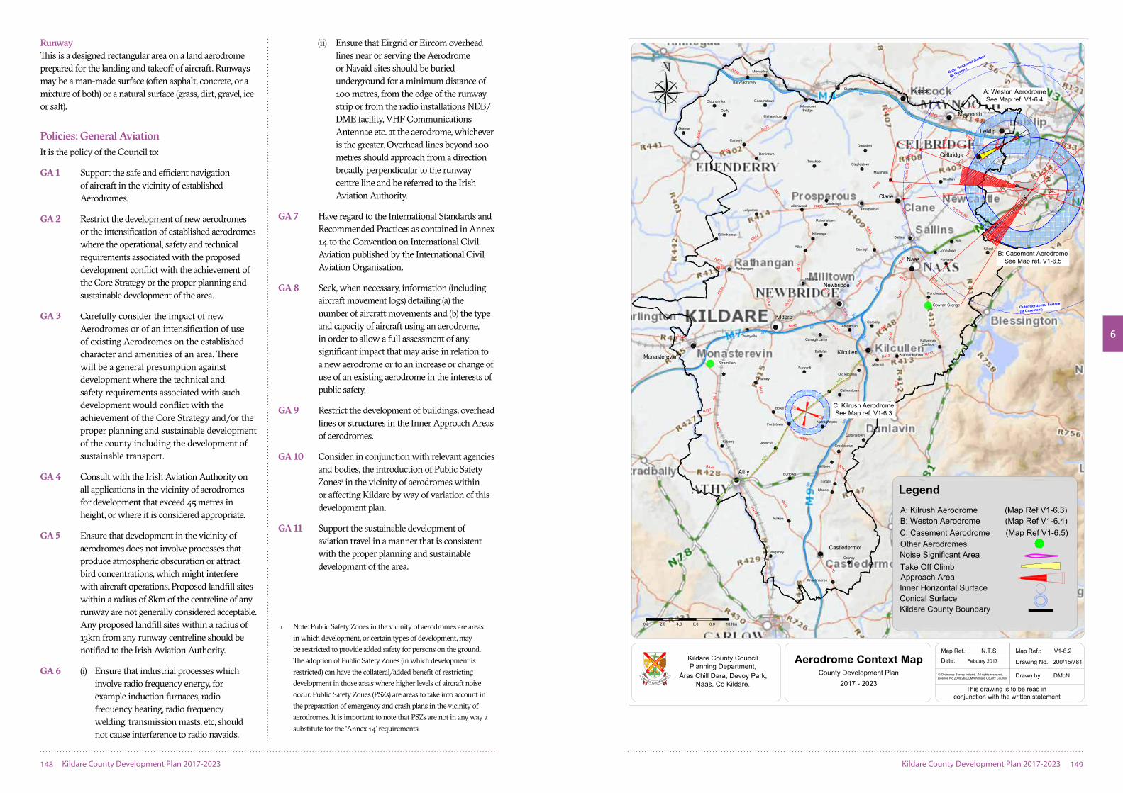
This section of the Plan sets out the general restrictions on development in the vicinity of aerodromes within or adjoining County Kildare. It is a responsibility of the Irish Aviation Authority (IAA), when notified, to evaluate planning applications which might affect the safe and efficient navigation of aircraft and to advise the Council of potential hazards to air navigation.
The safeguarding requirements in the vicinity of civil aerodromes are principally set out as International Standards and Recommended Practices within ‘Annex 14 of the Convention on International Civil Aviation’, which is published by the International Civil Aviation Organisation (ICAO) and IAA.
In 2014, the IAA introduced an online facility called ‘Asset’ which (a) provides details and plotted guidance in relation to aeronautical restrictions, and (b) would allow a developer to carry out an initial assessment of a proposed development in relation to such restrictions.
6.11.2 Terms and Definitions
The safeguarding requirements in the vicinity of civil aerodromes are principally set out as International Standards and Recommended Practices within “Annex 14 to the Convention on International Civil Aviation” published by the ICAO. The IAA also provides guidance material on Aerodrome Annex 14 Surfaces (2015). These provide dimensions and the basic criteria varying in relation to the size, shape and usage of different aerodromes.
Additional aeronautical restrictions may arise in relation to any Communication, Navigation or Surveillance (CNS) facilities under the IAA’s control (such as DVOR/DME facilities at Weston Aerodrome). Proposed developments
which might affect such CNS facilities would be assessed under the IAA’s two step process described in the policy document of 2015. The documents provide dimensions and basic criteria needed for the preparation of safeguarding maps for all civil aerodromes, with dimensions and criteria varying in relation to the size, shape and usage of different aerodromes. The locations of Aerodromes at Kilrush, Weston, Casement, Stramillan and Gowran Grange, are outlined on Map 6.2.
Airport/Aircraft Noise Airport-generated noise may affect areas around and in line with its runways. Maximum permitted air craft levels are set by ICAO, with limits and methods of calculation for each classification of aircraft set out in the ICAO’s ‘Annex 16- Environmental Protection Volume 1: Aircraft Noise.’ Compliance with Annex 16 noise standards is regulated within the EU by the European Aviation Safety Agency and within individual States by the aircraft registration authorities (i.e. by the IAA for Irish registered [‘E.I.-‘ reg] aircraft).
Reference CodesFor Obstacle Limitation purposes Code 1, Code 2, Code 3 or Code 4 refer broadly to the length(s) of runway(s) at an airport or aerodrome. (“Aerodrome” and “airport” have the same meaning in the above context).
Department of DefenceCasement Aerodrome at Baldonnell (being a military aerodrome) does not fall under the control of the IAA. However, ICAO Standards and Recommended Practices are generally applied as policy by the Department of Defence at Casement Aerodrome.
StopwayThis is defined by ICAO as ‘a defined rectangular area on the ground at the end of take-off run available prepared as a suitable area in which an aircraft can be stopped in the case of an abandoned take-off’. In effect a Stopway is a physical paving which increases the “Accelerate-stop distance available” [ASDA].
ClearwayThis is defined by ICAO as ‘a defined rectangular area on the ground or water under the control of the appropriate authority, selected or prepared as a suitable area over which an aeroplane may make a portion of its initial climb to a specified height. It can be a different/greater length than a Stopway and in effect it is not a physical item but is a wide clear airspace which increases the “take-off distance available” [TODA].
1 Microprocessor Optimised Vehicle Actuation is control software to self-optimise the control system for traffic signals.
2 SCOOT (Split Cycle Offset Optimisation Technique) is a tool for managing and controlling traffic signals in urban areas.
6
148 Kildare County Development Plan 2017-2023 Kildare County Development Plan 2017-2023 149
RunwayThis is a designed rectangular area on a land aerodrome prepared for the landing and takeoff of aircraft. Runways may be a man-made surface (often asphalt, concrete, or a mixture of both) or a natural surface (grass, dirt, gravel, ice or salt).
Policies: General AviationIt is the policy of the Council to:
GA 1 Support the safe and efficient navigation of aircraft in the vicinity of established Aerodromes.
GA 2 Restrict the development of new aerodromes or the intensification of established aerodromes where the operational, safety and technical requirements associated with the proposed development conflict with the achievement of the Core Strategy or the proper planning and sustainable development of the area.
GA 3 Carefully consider the impact of new Aerodromes or of an intensification of use of existing Aerodromes on the established character and amenities of an area. There will be a general presumption against development where the technical and safety requirements associated with such development would conflict with the achievement of the Core Strategy and/or the proper planning and sustainable development of the county including the development of sustainable transport.
GA 4 Consult with the Irish Aviation Authority on all applications in the vicinity of aerodromes for development that exceed 45 metres in height, or where it is considered appropriate.
GA 5 Ensure that development in the vicinity of aerodromes does not involve processes that produce atmospheric obscuration or attract bird concentrations, which might interfere with aircraft operations. Proposed landfill sites within a radius of 8km of the centreline of any runway are not generally considered acceptable. Any proposed landfill sites within a radius of 13km from any runway centreline should be notified to the Irish Aviation Authority.
GA 6 (i) Ensure that industrial processes which involve radio frequency energy, for example induction furnaces, radio frequency heating, radio frequency welding, transmission masts, etc, should not cause interference to radio navaids.
(ii) Ensure that Eirgrid or Eircom overhead lines near or serving the Aerodrome or Navaid sites should be buried underground for a minimum distance of 100 metres, from the edge of the runway strip or from the radio installations NDB/DME facility, VHF Communications Antennae etc. at the aerodrome, whichever is the greater. Overhead lines beyond 100 metres should approach from a direction broadly perpendicular to the runway centre line and be referred to the Irish Aviation Authority.
GA 7 Have regard to the International Standards and Recommended Practices as contained in Annex 14 to the Convention on International Civil Aviation published by the International Civil Aviation Organisation.
GA 8 Seek, when necessary, information (including aircraft movement logs) detailing (a) the number of aircraft movements and (b) the type and capacity of aircraft using an aerodrome, in order to allow a full assessment of any significant impact that may arise in relation to a new aerodrome or to an increase or change of use of an existing aerodrome in the interests of public safety.
GA 9 Restrict the development of buildings, overhead lines or structures in the Inner Approach Areas of aerodromes.
GA 10 Consider, in conjunction with relevant agencies and bodies, the introduction of Public Safety Zones1 in the vicinity of aerodromes within or affecting Kildare by way of variation of this development plan.
GA 11 Support the sustainable development of aviation travel in a manner that is consistent with the proper planning and sustainable development of the area.
Carbury
JohnstownBridge
Allenwood
Rathangan
Fontstown
Crookstown
Prosperous
Killkea
Ballynadrumny
Moyvalley
Cadamstown
Duffy
Clogharinka
Grange
Kilshanchoe
Cloncurry
Timahoe
Donadea
Staplestown
Mainham
Cooleragh
Lullymore
Killinthomas
Milltown
Allen
Kilmeage
Robertstown
Carragh
Sallins
Straffan
Kill
Johnstown
Furness
Kilteel
Punchestown
Knocknacree
Graney
Maganey
Timolin
Moone
Burtown
Ardscull
Colbinstown
Kilgowan
Calverstown
Boley
Kilberry
Nurney
Suncroft
Old kilcullen
Brannockstown
Milemill
Curragh camp
AthgarvanCorbally
Cherryville
Ballyfair
Derrinturn
Ballitore
0.0 2.0 4.0 6.0 8.0 10.Km
05
23
11
29
M7
M9
M4
N7
M7
R148
M4
M7
M7
N78
N78
M9
R418R417
R415
R415
R417
R427
R428
R418
R747
R410
R411
R41
2
R448
R413
R41
2
R413
R416
R445
R416
R413
R413
R415
R41
5
R401
R44
8
R409
R407
R403
R414
R401
R419
R414
R424
R403
R402
R402
R40
1
R407
R40
6
R405
R403
R403
R148
R157
R148
N7
M7
M7
R41
7
R445
R408
M4
M4
R148
R449
R404
M9
R445
R447
R408
N81
N81
Co. Kildare
10,000M
15,000M
C: Kilrush AerodromeSee Map ref. V1-6.3
B: Casement AerodromeSee Map ref. V1-6.5
A: Weston AerodromeSee Map ref. V1-6.4
Narraghmore
EustaceBallymore
196.3m O.D.
236.
6m O
.D.
Outer Horizontal Surface
(at Casement)
Outer Horizontal Surface
(at Weston)
Stramillan
Gowran Grange
Date: Febuary 2017
Map Ref.: V1-6.2
Drawing No.: 200/15/781
Drawn by: DMcN.
Map Ref.: N.T.S.
Aerodrome Context MapCounty Development Plan
2017 - 2023© Ordnance Survey Ireland. All rights reserved.Licence No 2009/26/CCMA Kildare County Council
This drawing is to be read inconjunction with the written statement
Kildare County CouncilPlanning Department,
Áras Chill Dara, Devoy Park,Naas, Co Kildare.
A: Kilrush Aerodrome (Map Ref V1-6.3)B: Weston Aerodrome (Map Ref V1-6.4)C: Casement Aerodrome (Map Ref V1-6.5)Other Aerodromes
Take Off ClimbNoise Significant Area
Kildare County BoundaryConical Surface
Approach AreaInner Horizontal Surface
Legend
1 Note: Public Safety Zones in the vicinity of aerodromes are areas in which development, or certain types of development, may be restricted to provide added safety for persons on the ground. The adoption of Public Safety Zones (in which development is restricted) can have the collateral/added benefit of restricting development in those areas where higher levels of aircraft noise occur. Public Safety Zones (PSZs) are areas to take into account in the preparation of emergency and crash plans in the vicinity of aerodromes. It is important to note that PSZs are not in any way a substitute for the ‘Annex 14’ requirements.

6
150 Kildare County Development Plan 2017-2023 Kildare County Development Plan 2017-2023 151
6.11.3 Kilrush Aerodrome (Map 6.3)
Location and DescriptionKilrush Aerodrome is one of only a few small (and currently unlicensed) aerodromes wholly located in County Kildare. It is located beside the R418 road, between Kilcullen and Athy. Aeronautical restriction will particularly affect development in the nearby elevated area of Bullhill.
Policy: Kilrush AerodromeIt is the policy of the Council to:
KA 1 Safeguard the operational, safety and technical requirements of Kilrush Aerodrome.
Objective: Kilrush AerodromeIt is an objective of the Council to:
KAO 1 Work to ensure that any further development within a 2.7km radius of Kilrush Aerodrome’s runways will be governed by limitations as set down by the ICAO in Annex 14, this includes both Inner Horizontal Surface (2Km) and Conical Surface (plus 0.7Km). The planning authority will consult with the Irish Aviation Authority on development within this area.
6.11.4 Weston Aerodrome (Map 6.4)
Location and Description Weston Aerodrome is located to the south of Leixlip, on lands either side of the boundary between County Kildare and South Dublin County. The majority of the aerodrome, runway and associated infrastructure is located on lands within the South Dublin County Council administrative area, with the runways Stopway and Clearway located in County Kildare. The Lyons Hill area is affected by the Outer Horizontal Surface for Weston Aerodrome (which is at 196.3m OD elevation).
Policy: Weston AerodromeIt is the policy of the Council to:
WA 1 Have regard to the advice of the statutory bodies responsible for the control and safety of operations at Weston Aerodrome, to prevent encroachment of development around the Aerodrome which may interfere
with its safe operation in the context of proper planning and sustainable development of the area and the protection of amenities.
Objectives: Weston AerodromeIt is an objective of the Council to:
WAO 1 Prevent encroachment of development in the vicinity of Weston Aerodrome which may interfere with its safe operation.
WAO 2 Have regard to the advice of the statutory bodies responsible for the control and safety of operations at Weston Aerodrome, in the context of the proper planning and sustainable development of the area and the protection of amenities.
WAO 3 Refer any development within 3.6km of Weston Aerodrome’s runway (i.e. within the area of its Horizontal and Conical Surfaces) to the Irish Aviation Authority, and also to refer to the IAA any development of 50m or greater in height above ground level within a 10km radius of Weston Aerodrome (i.e. within the area of its Outer Horizontal Surface).
WAO 4 Seek to develop a common protocol with South Dublin County Council to guide the consideration of applications at Weston.
6.11.5 Casement Aerodrome (Map 6.5)
Location and Description Casement Aerodrome is located wholly within South Dublin County, at about 2.5 kilometres from the nearest point on the county boundary with Kildare. It is the principal State military aerodrome, with substantial fixed-wing training and helicopter operations.
SafeguardingIt is the general policy of the Department of Defence that the ICAO civil aviation standards and recommended practices be adopted in relation to Casement Aerodrome. In several areas in Kildare the land lies above various Obstacle Limitation Surfaces generated from Casement Aerodrome.
The following should be noted:
(a) The safeguarding in relation to the Code 4 and Code 3 runways at Casement Aerodrome restricts development (to a very significant extent in certain areas) on the approach to its subsidiary runway 05, for a distance of up to 15km from that runway, of which more than 10km on the approach lies above County Kildare (reaching to the outskirts of Naas).
(b) The village of Kilteel and its immediate surroundings lie above an approach surface to Casement Aerodrome. Development in this area (and in all areas above 236.6m elevation being the elevation of Casement Aerodrome’s Outer Horizontal Surface) will be monitored and restricted (including any masts or aerials).
(c) Lyons Hill in Kildare is affected by the obstacle limitation surfaces of Casement Aerodrome and Weston Aerodrome.
(d) The western approach to the main runway at Casement lies directly to the south of Celbridge. Development of normal height is unlikely to be problematic in that location.
Policy: Casement AerodromeIt is the policy of the Council to:
CA 1 Safeguard the current and future operational, safety and technical requirements of Casement Aerodrome and to facilitate its ongoing development for military and ancillary uses within a sustainable development framework.
Objective: Casement AerodromeIt is and objective of the Council to:
CAO 1 Refer significant / major new development within approximately 6km of Casement Aerodrome or at Kilteel, to the Department of Defence.
6.11.6 Other Aerodromes
There are two other aerodromes located wholly in County Kildare at Gowran Grange, Punchestown and Stramillan, Monasterevin that are currently unlicensed.
Policy: Other Aerodromes It is the policy of the Council to:
AF 1 Consult with the Irish Aviation Authority in relation to proposed developments in other aerodromes in the county and in the vicinity of these aerodromes.

6
152 Kildare County Development Plan 2017-2023 Kildare County Development Plan 2017-2023 153
Con
ical
Sur
face
at (
Kilr
ush)
172.
35m
O.D
.
137.
35m
O.D
.
Inne
r Hor
izon
tal S
urfa
ceat
(K
ilrus
h) 1
37.3
5m O
.D.
Kilr
ush
Aer
odro
me
Elev
atio
n: 9
2.35
m O
.D.
111.
55m
O.D
.
104.
35m
O.D
104.35m O.D
111.55m O.D
104.
35m
O.D
111.
55m
O.D
.
104.35m O.D
111.55m O.D
Sca
le:
N
.T.S
.
Dat
e:
Fe
brua
ry 2
017
Map
Ref
.:
V
1-6.
3
Dra
win
g N
o.:
200/
15/7
78
Dra
wn
by:
B
.Rya
n
Kilr
ush
Aer
odro
me
Cou
nty
Dev
elop
men
t Pla
n20
17 -
2023
Thi
s dr
awin
g is
to b
e re
ad in
conj
unct
ion
with
the
writ
ten
stat
emen
t
1280
0.0
320
640
960
1600
m
© O
rdna
nce
Sur
vey
Irela
nd.
All
right
s re
serv
ed.
Lice
nce
No2
009/
26/C
CM
A K
ildar
e C
ount
y C
ounc
il
Lege
nd
Con
ical
Sur
face
App
roac
h A
rea
Inne
r Hor
izon
tal S
urfa
ce
Kild
are
Cou
nty
Cou
ncil
Pla
nnin
g D
epar
tmen
t,Á
ras
Chi
ll D
ara,
Dev
oy P
ark,
Naa
s, C
o K
ildar
e.
t
Take
off
Clim
b
86.
33m
76.3
3m O
.D
Appr
oach
58.3
3m O
.D
App
roac
h
Take
-off
46.3
3m O
.D
Co.
Kild
are
Co.
Dub
lin
Co.
Dub
linC
o. K
ildar
e
146.
33m
O.D
.
196.3m O.D.
236.6m O.D.
Inne
r Hor
izon
tal S
urfa
ceat
(Wes
ton)
91.
33m
O.D
.
Wes
ton
Aer
odro
me
Elev
atio
n: 4
6.33
m O
.D.
Runw
ay
App
roac
h
Cle
arw
ay &
Sto
pway
Coni
cal S
urfa
ce
(Wes
ton)
580m
580m
580m
Coni
cal S
urfa
ce
(Wes
ton)
91.3
3m O
.D.
Take
Off
Clim
bW
esto
n A
erod
rom
e C
ount
y D
evel
opm
ent P
lan
2017
- 20
23
Noi
se S
igni
fican
t Are
aS
cale
:
N.T
.S.
Dat
e:
Feb
ruar
y 20
17
Map
Ref
.:
V
1-6.
4
Dra
win
g N
o.:
200/
15/7
79
Dra
wn
by:
B
.Rya
n
Thi
s dr
awin
g is
to b
e re
ad in
conj
unct
ion
with
the
writ
ten
stat
emen
t
Kild
are
Cou
nty
Cou
ncil
Pla
nnin
g D
epar
tmen
t,Á
ras
Chi
ll D
ara,
Dev
oy P
ark,
Naa
s, C
o K
ildar
e.
Kild
are
Cou
nty
Bou
ndar
y
Lege
nd
Con
ical
Sur
face
App
roac
h A
rea
Inne
r Hor
izon
tal S
urfa
ce©
Ord
nanc
e S
urve
y Ire
land
. A
ll rig
hts
rese
rved
.Li
cenc
e N
o200
9/26
/CC
MA
Kild
are
Cou
nty
Cou
ncil

6
154 Kildare County Development Plan 2017-2023 Kildare County Development Plan 2017-2023 155
86.6
m O
.D.
97.2m O.D.
Approac
h to
Casem
ent r
unway 05
Co Kildare
Approach toCasement runway 11
0.0 800 1600 2400 3200 4000m
Co. Dublin
196.3m O.D.
176.4m O.D.
165.
8m O
.D.
93.33m O.D.
146.33m O.D.
131.6m O.D.
231.6m O.D.
Co. Kildare Co. Dublin
236.6m O
.D.
See Map Ref 6.4Weston Aerodrome
Conical Surface ( Casement )
15,000 Km
10,000 Km
Inner Horizontal Surfaceat (Casement) 131.6m O.D.
Casement AerodromeElevation: 86.6m O.D.
Outer Horizontal Surface
at (Casement)
Outer Horizontal Surface
at (Weston)
Scale: N.T.S.
Date: February 2017
Map Ref.: V1-6.5
Drawing No.: 200/15/780
Drawn by: B.Ryan
Casement AerodromeCounty Development Plan
2017 - 2023 This drawing is to be read inconjunction with the written statement
© Ordnance Survey Ireland. All rights reserved.Licence No 2009/26/CCMA Kildare County Council
Kildare County CouncilPlanning Department,
Áras Chill Dara, Devoy Park,Naas, Co Kildare.
Kildare County Boundary
Conical Surface
Approach AreaInner Horizontal Surface
Legend