Pollution Prevention Guideline Above Ground Oil Storage Tanks: PPG2

Final Scoping Report March
2013 Houhoek Transmission Substation & Bacchus-Palmiet Loop-in/Loop-out power lines, Western Cape
P:\J01887 - Houhoek Substation\09 - Reports\03 Final Scoping Report\J01887 Final Scoping Report v4 2013-03-06.docx Page 79
6 LEGISLATION AND GUIDELINE DOCUMENTS
6.1 APPLICABLE ENVIRONMENTAL LEGISLATION
A limited scoping of relevant legislation was undertaken to identify the key legal issues
related to the Houhoek Transmission Substation project. The applicable key environmental
legislation that Eskom must consider during the implementation of the Houhoek
Transmission Substation project is summarised in Table 6-1.
Table 6-1: Summary of Applicable Legislation
Legislation Sections Relates to:
The Constitution
(No. 108 of 1996)
Chapter 2 Bill of Rights
Section 24 Environmental rights
Section 25 Rights in property
Section 32 Administrative justice
Section 33 Access to information
National
Environmental
Management
(No. 107 of 1998)
as amended3
Section 2
The national environmental management principles is in
Chapter 1 of the Act, essentially guide the interpretation
and administration and implementation of the Act and
any other law concerned with the protection of the
environment.
An overarching emphasis of the principle that
development must be environmentally, socially and
economically sustainable.
Applies throughout the Republic to the actions of all
organs of state that may significantly affect the
environment.
Section 24
Chapter 5 of the Act deals with integrated environmental
management, including environmental impact
assessments. Section 24 requires the applicant of an
environmental authorisation to consider, investigate,
assess and report the consequences for or impacts on the
environment of the listed activity or specified activity to
the competent authority.
Section 28
Section 28 imposes a duty of care on every person who
causes, has caused, or may cause significant pollution or
environmental degradation to take reasonable measures
to prevent such pollution or degradation from occurring,
continuing or recurring.
The scheme owner has a general duty to care for the
environment and to institute such measures as may be
needed to demonstrate such care.
3 The EIA Regulations (2010) R543, R544, R545 and R546 may be relevant for certain construction and maintenance activities, such as those that may need to take place in or close to water resources.

Final Scoping Report March
2013 Houhoek Transmission Substation & Bacchus-Palmiet Loop-in/Loop-out power lines, Western Cape
P:\J01887 - Houhoek Substation\09 - Reports\03 Final Scoping Report\J01887 Final Scoping Report v4 2013-03-06.docx Page 80
Legislation Sections Relates to:
The duty of care has been amended to include significant
pollution or degradation that occurred before the
commencement of the NEMA that arises or is likely to
arise at a different time from the actual activity that
caused the contamination or that arises through an act or
activity of a person that results in a change to pre-existing
contamination.
Section 30
Control of emergency incidents. Responsible person’s
duties relating to reporting and remediation actions
regarding emergency incidents.
A criminal sanction may be imposed on the responsible
person for failure to comply with the reporting
requirements and obligations to address any emergency
incidents.
Environment
Conservation Act
(No. 73 of 1989)
and regulations
The Act has been substantially repealed by the NEMA. However, there are
certain regulations under the Act which are still in operation, such as the
National Noise Control Regulations.
National
Environmental
Management:
Protected Areas Act
(No. 57 of 2003)
The Protected Areas Act No. 57 of 2003 was signed into law on 18 February
2004, and came into operation on 01 November 2004.
The aim of the Act is to provide for the protection and conservation of
ecologically viable areas representative of South Africa's biological
diversity, natural landscapes and seascapes.
The Act repeals sections 16, 17 & 18 of the ECA. In 2004, the National
Environmental Management: Protected Areas Amendment Act No. 31 of
2004 was promulgated to amend Act 57 of 2003 with regard to the
application of that Act to national parks and marine protected areas.
The amendment Act came into operation on 01 November 2005 and it also
repeals the National Parks Act with the exception of section 2(1) and
Schedule 1.
The Act operates in conjunction with the National Environmental
Management: Biodiversity Act No. 10 of 2004.
National
Environmental
Management:
Biodiversity Act
(No. 10 of 2004)
(NEM:BA)
Sections 65-69
These sections deal with restricted activities involving
alien species; restricted activities involving certain alien
species totally prohibited; and duty of care relating to
alien species.
Sections 71
and 73
These sections deal with restricted activities involving
listed invasive species and duty of care relating to listed
invasive species.
Conservation of
Agricultural
Resources Act (No.
43 of 1983)
and regulations
Sections 2, 5,
6
Implementation of control measures for soil conservation
works as well as alien and invasive plant species in and
outside of urban areas.

Final Scoping Report March
2013 Houhoek Transmission Substation & Bacchus-Palmiet Loop-in/Loop-out power lines, Western Cape
P:\J01887 - Houhoek Substation\09 - Reports\03 Final Scoping Report\J01887 Final Scoping Report v4 2013-03-06.docx Page 81
Legislation Sections Relates to:
National Water Act
(No. 36 of 1998)
and regulations
Section 19 Prevention and remedying the effects of pollution.
Section 20 Control of emergency incidents.
Section 21 The DWA will require water use licences for various
construction-related activities.
Section 26 and
34
Registration of water use regarding the discharging of
waste or water containing waste into a water resource
through a pipe, canal, sewer, sea outfall or other conduit
and disposing of waste in a manner that may
detrimentally impact on a water resource.
National Heritage
Resources Act
(No. 25 of 1999)
Section 35
No person may, without a permit issued by the
responsible heritage resources authority destroy,
damage, excavate, alter, deface or otherwise disturb any
archaeological or paleontological site.
Section 36
No person may, without a permit issued by the SAHRA or
HWC to destroy, damage, alter, exhume, remove from its
original position or otherwise disturb any grave or burial
ground older than 60 years which is situated outside a
formal cemetery administered by a local authority.
"Grave" is widely defined in the Act to include the
contents, headstone or other marker of such a place, and
any other structure on or associated with such a place.
Section 38
This section provides for a HIA, which is not covered
under the ECA. The HIA will be approved by the DEA,
which is required to take SAHRA’s and HWC’s comments
into account prior to making a decision on the HIA.
Removal of Graves
and Dead Bodies
Ordinance 7 of 1925
Authorisation for exhumation and re-internment of human remains must
be obtained from the relevant local authority where the grave is situated,
as well as where the grave is being relocated to.
National
Environmental
Management: Air
Quality Act
(No. 39 of 2004)
Section 32 Control of dust
Section 34 Control of noise
Section 35 Control of offensive odours
Chapter 5 Licensing of listed activities
Schedule 2 Ambient air quality standards
National
Environmental
Management: Waste
Act (No. 59 of 2008)
Section 16 General duty in terms of waste management
Section 17 Reduction, re-use, recycling and recovery of waste
Section 20
No person may commence, undertake or conduct a waste
management activity, except in accordance with:
the requirements or standards prescribed by said Act
and regulations; and
a waste management licence issued in respect of that
activity, if a licence is required.
Section 26 Prohibition of unauthorised disposal of waste
Section 27 Prohibition of littering

Final Scoping Report March
2013 Houhoek Transmission Substation & Bacchus-Palmiet Loop-in/Loop-out power lines, Western Cape
P:\J01887 - Houhoek Substation\09 - Reports\03 Final Scoping Report\J01887 Final Scoping Report v4 2013-03-06.docx Page 82
Legislation Sections Relates to:
South African
National Roads
Agency Limited and
National Roads Act,
1998 (No. 7 of 1998):
1. Damaging a
National Road
Section 5(a)
and (b)
The Agency may issue a written notice demanding that
the owner or occupier prevents or stops any activity that
may cause damage to a national road.
The demand may include, among others, the removal,
filling in, alteration, relocation or establishment of any
dam, canal, trench, wall, sluice, pipe, excavation,
structure or other works, or the cessation of such an act,
on the land.
Section 46(3)
The owners or occupiers of land adjoining any national
road must:
Take all measures on their land that are reasonably
necessary to prevent the occurrence of any damage to
the national road concerned.
Refrain from doing or permitting anything on or below
the surface of that land which is likely to cause
damage to that national road.
Section 46(4)
The owner or occupier of any land adjoining a national
road will be held liable for any damage to the national
road which was or reasonably should have been foreseen.
South African
National Roads
Agency Limited and
National Roads Act
(No. 7 of 1998):
3. Structures and
other works on, over
or below national
roads or certain
other land
Section 48(1)
No person may do any of the following without the
Agency’s permission:
On or over, or below the surface of, a national road
erect, construct or lay, or establish any structure.
Make any structural alteration or addition to a
structure situated on or over, or below the surface of a
national road.
Give permission for either (a) or (b).
Section 48(5)
The Agency may give written notice for the removal of
any such structure, or may remove the structure and
recover the costs from that person.
Section 48(8) Any person who contravenes this section is guilty of an
offence and liable to one year in prison and/or a fine.
Explosives Act
(No. 15 of 2003)
and regulations
Provisions for the control of explosives in terms of use, disposal, storage,
transportation, dealing, importation, exportation and packaging of
explosives.
Occupational Health
and Safety Act
(No. 85 of 1993)
and regulations
General
Administration
Regulations
GN R929 of
June 2003
Material Safety Data Sheets must be made available at
the request of any interested or affected party.
Section 8 General duties of employers to their employees.
Section 9 General duties of employers and self-employed persons
to persons other than their employees.

Final Scoping Report March
2013 Houhoek Transmission Substation & Bacchus-Palmiet Loop-in/Loop-out power lines, Western Cape
P:\J01887 - Houhoek Substation\09 - Reports\03 Final Scoping Report\J01887 Final Scoping Report v4 2013-03-06.docx Page 83
Legislation Sections Relates to:
Fencing Act
(No. 31 of 1963) Section 17
Any person erecting a boundary fence may clean any
bush along the line of the fence up to 1.5 metres on each
side thereof and remove any tree standing in the
immediate line of the fence. However, this provision must
be read in conjunction with the environmental legal
provisions relevant to the protection of flora.
Hazardous
Substances Act (No.
15 of 1973)
and regulations
Provides for the definition, classification, use, operation, modification,
disposal or dumping of hazardous substances.
Fertilisers, Farm
Feeds, Agricultural
Remedies and Stock
Remedies Act
(No. 36 of 1947)
and regulations
Sections 3-10
Control of the use of registered pesticides, herbicides
(weed killers) and fertilisers.
Special precautions must be taken to prevent workers
from being exposed to chemical substances in this regard.
Workers handling these remedies must also be registered
in terms of the Act.
National Road Traffic
Act (No. 93 of 1996)
and regulations
Section 54 Transportation of dangerous goods.
National Veld and
Forest Fire Act
(No. 101 of 1998)
Chapter 2
Promotes and regulates the formation of fire protection
associations which aim to manage and coordinate fire
protection and fire services in an area.
Chapters 4 & 5
Organisations are required to make and maintain
firebreaks and fire-fighting equipment and personnel
should a risk exist that a fire may start or spread from the
premises.
Subdivision of
Agricultural Land Act
(No. 70 of 1970)
To control the subdivision and, in connection therewith, the use of
agricultural land.
SANS 1929 Ambient air quality – limits for common pollutants.
SANS 10103 The measurement and rating of environmental noise with respect to land
use, health, annoyance and to speech communication.
SANS 10128 Bunding of fuel storage tanks.
6.2 NATIONAL ENVIRONMENTAL MANAGEMENT ACT
The National Environmental Management Act (No. 107 of 1998) (NEMA), provides a
framework for cooperative environmental governance between the various spheres of
government, by establishing principles for decision-making on matters relating to the
environment. Furthermore, NEMA promotes integrated management to ensure sustainable
resource utilisation and development and requires that the DEA be the lead agent in
ensuring effective custodianship of the environment. It also provides that sensitive,
vulnerable, highly dynamic or stressed ecosystems, such as coastal shores, estuaries,
wetlands, and similar systems require specific attention in management and planning
Final Scoping Report March
2013 Houhoek Transmission Substation & Bacchus-Palmiet Loop-in/Loop-out power lines, Western Cape
P:\J01887 - Houhoek Substation\09 - Reports\03 Final Scoping Report\J01887 Final Scoping Report v4 2013-03-06.docx Page 84
procedures, especially where subjected to significant human resource usage and
development pressure.
The NEMA principles, contained in Section 2, clearly emphasise the need to protect
threatened ecosystems and are binding on all organs of state, including local authorities.
The national environmental management principles contained in Chapter 1 of NEMA apply
to the actions of all organs of state that may significantly affect the environment and serve
as guidelines by reference to which organs of state shall exercise their functions when taking
a decision in terms of NEMA. The principles will furthermore guide the interpretation,
administration and implementation of NEMA and any other law concerned with the
protection of the environment.
Sections 24 and 44 of NEMA make provision for the promulgation of regulations that identify
activities which may not commence without an environmental authorisation, the result
being that NEMA began governing the EIA process with the promulgation of the
EIA Regulations in April 2006 (Government Gazette No. 28753 of 21 April 2006). These
regulations have subsequently been replaced by the NEMA EIA 2010 Regulations listed in
Government Gazette No. 33306 of 18 June 2010 (GN543, 544, 545 and 546 of 18 June 2010,
as amended). The NEMA EIA 2010 Regulations are contained in four Government Notices
and came into effect on 2 August 2010, as amended.
Applications listed in these regulations will require an environmental authorisation (EA) from
the relevant competent authority, which in this case is the DEA as Eskom SOC Limited is a
state-owned company or so-called parastatal entity.
Section 24(f) of the NEMA prohibits the undertaking of identified activities except by virtue
of a competent authority.
On submission of an application the competent authority must consider all the relevant
information contained in the Scoping Report and EIA Report (including any pollution,
environmental impacts or environmental degradation likely to be caused if the application is
approved or refused) and thereafter make a decision of whether or not to grant an
environmental authorisation to the proposed project.
Certain minimum conditions are attached to environmental authorisations, as required by
Section 24E of NEMA, however it is at the competent authorities discretion to include
additional project specific conditions. In terms of section 24F of NEMA it is an offence not to
comply with any condition applicable to an environmental authorisation issued for a listed
activity.
Typical conditions that may be applied by the competent authority include, but is not limited
to:
measures to prevent, manage and mitigate environmental impacts to acceptable levels;
prevention of pollution of water bodies and groundwater;
a rehabilitation programme for disturbed natural and/or heritage areas;
appointment of an independent Environmental Control Officer (ECO) to oversee the
construction phase and to ensure that the development phase is conducted in an
environmentally responsible manner;
Final Scoping Report March
2013 Houhoek Transmission Substation & Bacchus-Palmiet Loop-in/Loop-out power lines, Western Cape
P:\J01887 - Houhoek Substation\09 - Reports\03 Final Scoping Report\J01887 Final Scoping Report v4 2013-03-06.docx Page 85
conservation management and visitor management plans; and
requirements of other authorities, such as the Department of Water Affairs (DWA), the
Department of Energy (DoE), the Department of Agriculture (DoA), the Department of
Mineral Resources (DMR) and the South African Heritage Resources Agency (SAHRA)
and/or relevant provincial authorities.
6.3 ACTIVITIES APPLICABLE TO EIA REGULATIONS (2010)
The construction of the Houhoek 400kV Transmission Substation and associated
infrastructure, falls within the ambit of the list of activities (Table 6-2) identified in terms of
Sections 24(2)(a) and (d) of the NEMA. Note that comments on the listed activities are
presented in the table, as identified by being in italics.
Table 6-2: Listed Activities in Terms of NEMA
Number &
Date of
Relevant
Notice
Activity
No(s) Description of Each Listed Activity
Description of Activities Applicable to
Each Listed Activity
LISTING NOTICE 1 – BASIC ASSESSMENT PROCESS
Listing
Notice 1:
GN R No.
544 of
18 June
2010
10
The construction of facilities or
infrastructure for the transmission and
distribution of electricity:
(xi) outside urban areas or industrial
complexes with a capacity of more than
33kV but less than 275kV.
The Houhoek Transmission Substation
project entails the construction of a
400/132kV Substation, including 400kV
Transmission and 132kV Distribution
power lines and associated
infrastructure, outside of an urban area
/ industrial complex.
11
The construction of:
(xi) infrastructure or structures covering
50m2 or more,
where such construction occurs within a
watercourse or within 32m of a
watercourse, measured from the edge of a
watercourse, excluding where such
construction will occur behind a
development setback line.
The Houhoek Transmission Substation
project entails the construction of a
400/132kV Substation, including 400kV
Transmission and 132kV Distribution
power lines and associated
infrastructure. The associated power
lines or access roads, that link to the
substation, may cross drainage lines
and non-perennial watercourses.
13
The construction of facilities or
infrastructure for the storage, or for the
storage and handling, of a dangerous good,
where such storage occurs in containers
with a combined capacity of 80m3 but not
exceeding 500m3.
The construction camp may store
hazardous material for use in the
construction of the Houhoek
Transmission Substation project. The
substation design will include
transformer oil ponds. The combined
capacities of hazardous material and
the size of the ponds will be determined
during the EIA process, which will
inform whether this activity will apply.

Final Scoping Report March
2013 Houhoek Transmission Substation & Bacchus-Palmiet Loop-in/Loop-out power lines, Western Cape
P:\J01887 - Houhoek Substation\09 - Reports\03 Final Scoping Report\J01887 Final Scoping Report v4 2013-03-06.docx Page 86
Number &
Date of
Relevant
Notice
Activity
No(s) Description of Each Listed Activity
Description of Activities Applicable to
Each Listed Activity
Listing
Notice 1:
GN R No.
544 of
18 June
2010
18
The infilling or depositing of any material of
more than 5m3 into, or the dredging,
excavation, removal or moving of soil, sand,
shells, shell grit, pebbles or rock from:
(i) a watercourse.
The Houhoek Transmission Substation
project could entail the construction of
access roads for use during the
construction phase and operational
phase (for maintenance purposes)
which may cross over drainage lines
and non-perennial watercourses
occurring in the area. Note that it is
considered unlikely that access roads
should be required for this
development. Should the planning
process indicate otherwise the issues
related to this infrastructure
component would be considered in the
remainder of the EIA process.
The installation of pylons associated
with the LILO lines may also impact on
any cross drainage lines and non-
perennial watercourses or wetlands
encountered in the study area.
22
The construction of a road, outside urban
areas,
(i) with a reserve wider than 13,5 metres.
(ii) where no reserve exists where the road
is wider than 8m.
The Houhoek Transmission Substation
project could entail the construction of
access roads for use during the
construction phase and operational
phase (for maintenance purposes). The
exact characteristics of such roads will
be determined through the design
process which will inform the EIA
process.
24
The transformation of land bigger than
1,000m2 in size, to residential, retail,
commercial, industrial or institutional use,
where, at the time of the coming into effect
of this Schedule such land was zoned open
space, conservation or had an equivalent
zoning.
One of the proposed alternatives being
considered falls within the existing
Houhoek Nature Reserve, which is by
definition “conservation” in nature. The
Transmission Substation will be
approximately 12ha, which is
significantly larger than 1,000m2 (i.e.
0.1ha). The land-use proposed for the
Transmission Substation is industrial.
The combined servitude of the LILO
lines could also exceed 1,000m2
26
Any process or activity identified in terms of
Section 53(1) of the National Environmental
Management: Biodiversity Act (No. 10 of
2004).
The proposed Transmission and
Distribution power lines fall within
areas of importance in terms of
NEM:BA. The position of the
Transmission Substation itself will also
be influenced by the biodiversity status.

Final Scoping Report March
2013 Houhoek Transmission Substation & Bacchus-Palmiet Loop-in/Loop-out power lines, Western Cape
P:\J01887 - Houhoek Substation\09 - Reports\03 Final Scoping Report\J01887 Final Scoping Report v4 2013-03-06.docx Page 87
Number &
Date of
Relevant
Notice
Activity
No(s) Description of Each Listed Activity
Description of Activities Applicable to
Each Listed Activity
Listing
Notice 1:
GN R No.
544 of
18 June
2010
38
The expansion of facilities for the
transmission and distribution of electricity
where the expanded capacity will exceed
275 kilovolts and the development footprint
will increase.
The Houhoek Transmission Substation
project will link a 132kV Distribution
power line from the proposed 400kV
Transmission Substation to the existing
132kV Distribution Substation. The
Houhoek Transmission Substation
project could then entail the expansion
of the existing Eskom servitudes, which
will increase the development footprint.
40
The expansion of:
(iv) infrastructure by more than 50m2
within a watercourse or within 32m of a
watercourse, measured from the edge
of a watercourse.
The Houhoek Transmission Substation
project may require the placing of the
Transmission and/or Distribution power
lines and/or the Transmission
Substation along or across a drainage
or non-perennial water course.
47
The widening of a road by more than 6m, or
the lengthening of a road by more than 1km
–
(i) where the existing reserve is wider than
13.5m; or
(ii) where no reserve exists, where the
existing road is wider than 8m.
The Houhoek Transmission Substation
project could entail the expansion of
existing roads to use as access roads for
use during the construction phase and
operational phase (i.e. for maintenance
purposes).
LISTING NOTICE 3 – BASIC ASSESSMENT PROCESS
Listing
Notice 3:
GN R No.
546 of
18 June
2010
4
The construction of a road wider than 4m
with a reserve less than 13,5m (d) in
Western Cape Province: in (ii) all areas
outside urban areas.
The Houhoek Transmission Substation
project could entail the construction of
access roads for use during the
construction phase and operational
phase outside of an urban area. The
exact specification of any such roads
will be determined during the planning
phase and will inform the EIA process.
10
The construction of facilities or
infrastructure for the storage, or storage
and handling of a dangerous good, where
such storage occurs in containers with a
combined capacity of 30 but not exceeding
80m3, (e) in the Western Cape: in (ii) All
areas outside urban areas.
The construction camp may store
hazardous material for use in the
construction of the Houhoek
Transmission Substation project and the
substation design will include
transformer oil ponds. The capacities of
hazardous material and the size of the
ponds will be determined during the EIA
process, that is, the combined capacity
thereof will be confirmed during the EIA
and it will be determined whether this
activity is in fact triggered.

Final Scoping Report March
2013 Houhoek Transmission Substation & Bacchus-Palmiet Loop-in/Loop-out power lines, Western Cape
P:\J01887 - Houhoek Substation\09 - Reports\03 Final Scoping Report\J01887 Final Scoping Report v4 2013-03-06.docx Page 88
Number &
Date of
Relevant
Notice
Activity
No(s) Description of Each Listed Activity
Description of Activities Applicable to
Each Listed Activity
Listing
Notice 3:
GN R No.
546 of
18 June
2010
12
The clearance of an area of 300m² or more
of vegetation where 75% or more of the
vegetative cover constitutes indigenous
vegetation:
(a) Within any critically endangered or
endangered ecosystem listed in terms
of Section 52 of the NEM:BA or prior to
the publication of such a list, within an
area that has been identified as
critically endangered in the National
Spatial Biodiversity Assessment (2004).
(b) Within critical biodiversity areas
identified in bioregional plans.
Clearance land of vegetation for the
proposed power lines and substation
areas will be required to a greater or
lesser extent. The exact size of the area
of indigenous vegetation to be cleared
will be confirmed during the EIA phase,
along with the status of the footprint in
terms of its biodiversity status.
13
The clearance of an area of 1 hectare or
more of vegetation where 75% or more of
the vegetative cover constitutes indigenous
vegetation, except where such removal of
vegetation is required for (2) the
undertaking of a linear activity falling below
the thresholds mentioned in Listing Notice 1
in terms of GN R No. 544 of 2010.
(a) Critical biodiversity areas and ecological
support areas as identified in
systematic biodiversity plans adopted
by the competent authority.
(b) National Protected Area Expansion
Strategy Focus areas.
(c) in Western Cape: (ii) outside urban
areas, the following:
(aa) A protected area identified in
terms of NEMPAA, excluding
conservancies.
(bb) National Protected Area
Expansion Strategy Focus areas.
(cc) Sensitive areas as identified in an
environmental management
framework as contemplated in
Chapter 5 of the Act and as
adopted by the competent
authority.
(ee) Core areas in biosphere reserves.
(ff) Areas within 10km from national
parks or world heritage sites or
5km from any other protected
area identified in terms of
NEM:PAA or from the core area
of a biosphere reserve.
Clearance land of vegetation for the
proposed power lines and substation
areas will be required to a greater or
lesser extent. The exact size of the area
of indigenous vegetation to be cleared
will be confirmed during the EIA phase,
along with the status of the footprint in
terms of its biodiversity status.

Final Scoping Report March
2013 Houhoek Transmission Substation & Bacchus-Palmiet Loop-in/Loop-out power lines, Western Cape
P:\J01887 - Houhoek Substation\09 - Reports\03 Final Scoping Report\J01887 Final Scoping Report v4 2013-03-06.docx Page 89
Number &
Date of
Relevant
Notice
Activity
No(s) Description of Each Listed Activity
Description of Activities Applicable to
Each Listed Activity
Listing
Notice 3:
GN R No.
546 of
18 June
2010
14
The clearance of an area of 5 hectares or
more of vegetation where 75% or more of
the vegetative cover constitutes indigenous
vegetation:
(a) in the Western Cape: in (i) all areas
outside urban areas.
Clearance land of vegetation for the
proposed power lines and substation
areas will be required to a greater or
lesser extent. The exact size of the area
of indigenous vegetation to be cleared
will be confirmed during the EIA phase,
along with the status of the footprint in
terms of its biodiversity status.
16
The construction of: (xi) infrastructure or
structures covering 10m2 or more, where
such construction occurs within a
watercourse or within 32m of a
watercourse, measured from the edge of a
watercourse, excluding where such
construction will occur behind a
development setback line (d) in Western
Cape
(ii) Outside urban areas, in:
(aa) A protected area identified in
terms of NEMPAA, excluding
conservancies.
(bb) National Protected Area
Expansion Strategy Focus areas.
(dd) Sensitive areas as identified in an
environmental management
framework as contemplated in
Chapter 5 of the Act and as
adopted by the competent
authority.
(ff) Critical biodiversity areas or
ecosystems service areas as
identified in systematic
biodiversity plans adopted by the
competent authority or in
bioregional plans.
(gg) Core areas in biosphere reserves.
(hh) Areas within 10km from national
parks or world heritage sites or
5km from any other protected
area identified in terms of
NEMPAA or from the core areas
of a biosphere reserve.
The Houhoek Transmission Substation
project may have an impact on
biodiversity rich areas, and will have an
impact (direct/indirect) on the adjacent
Houwhoek Nature Reserve.

Final Scoping Report March
2013 Houhoek Transmission Substation & Bacchus-Palmiet Loop-in/Loop-out power lines, Western Cape
P:\J01887 - Houhoek Substation\09 - Reports\03 Final Scoping Report\J01887 Final Scoping Report v4 2013-03-06.docx Page 90
Number &
Date of
Relevant
Notice
Activity
No(s) Description of Each Listed Activity
Description of Activities Applicable to
Each Listed Activity
Listing
Notice 3:
GN R No.
546 of
18 June
2010
19
The widening of a road by more than 4m, or
the lengthening of a road by more than 1km
(d) in the Western Cape: in (ii) all areas
outside urban areas.
The Houhoek Transmission Substation
project could entail the construction of
access roads for use during the
construction phase and operational
phase (for maintenance purposes) – the
specifications thereof will be
determined during planning and will
inform the EIA process.
23
The expansion of facilities or infrastructure
for the storage, or storage and handling of a
dangerous good, where such storage occurs
in containers with a combined capacity of
30m3 but not exceeding 80m
3, (d) in the
Western Cape: in (ii) all areas outside urban
areas.
The construction camp will store
hazardous material for use in the
construction of the Houhoek
Transmission Substation project. During
operation hazardous substances will be
stored at the Substation. The capacities
of hazardous material will be
determined during the planning process
and will inform the EIA process.
24
The expansion of: (d) infrastructure where
the infrastructure will be expanded by 10m2
or more where such construction occurs
within a watercourse or within 32m of a
watercourse, measured from the edge of a
watercourse, excluding where such
construction will occur behind a
development setback line.
(d) in Western Cape (ii) outside urban
areas, in:
(aa) A protected area identified in
terms of NEMPAA, excluding
conservancies.
(bb) National Protected Area
Expansion Strategy Focus areas.
(cc) Sensitive areas as identified in an
environmental management
framework as contemplated in
Chapter 5 of the Act and as
adopted by the competent
authority.
(ee) Critical biodiversity areas as
identified in systematic
biodiversity plans adopted by the
competent authority or in
bioregional plans.
(ff) Core areas in biosphere reserves.
(gg) Areas within 10km from national
parks or world heritage sites or
5km from any other protected
The proposed power lines may cross
over drainage lines and non-perennial
watercourses and the study area falls
within the parameters of the triggering
environmental constraints.

Final Scoping Report March
2013 Houhoek Transmission Substation & Bacchus-Palmiet Loop-in/Loop-out power lines, Western Cape
P:\J01887 - Houhoek Substation\09 - Reports\03 Final Scoping Report\J01887 Final Scoping Report v4 2013-03-06.docx Page 91
Number &
Date of
Relevant
Notice
Activity
No(s) Description of Each Listed Activity
Description of Activities Applicable to
Each Listed Activity
area identified in terms of
NEMPAA or from the core areas
of a biosphere reserve.
LISTING NOTICE 2 – SCOPING/EIA PROCESS
Listing
Notice 2:
GN R No.
545 of
18 June
2010
8
The construction of facilities or
infrastructure, for the transmission and
distribution of electricity with a capacity of
275 kilovolts or more, outside an urban area
or industrial complex.
The Houhoek Transmission Substation
project entails the construction of
infrastructure for the transmission of
electricity with a capacity of 400kV,
outside an urban area.
6.4 NATIONAL WATER ACT
The National Water Act (No. 36 of 1998) (NWA) provides a framework to protect, develop,
conserve and manage the nation’s water resources. Water use is defined broadly in terms of
NWA, and includes taking and storing water, activities which reduce stream flow, waste
discharges and disposals, controlled activities (activities which impact detrimentally on a
water resource), altering a watercourse, removing water found underground for certain
purposes, and recreation. In general a water use must be licensed (in terms of Section 21)
unless it is listed in Schedule 1, is an existing lawful use, is permissible under a general
authorisation, or if a responsible authority waives the need for a licence. Section 21 of the
NWA lists the water uses for which authorisation under the Act is required.
The NWA also provides for pollution prevention measures, with particular emphasis on
water resource pollution. In accordance, the licensee shall ensure that activities impacting
upon water resources and effluent releases are monitored for compliance with the
applicable regulations. Emergency incidents involving water resources are included in the
Act, requiring the polluter to remediate and mitigate the impacts of such an emergency
incident.
6.4.1 Water Use Licence Application Process
a) Application
Pre-application liaison should occur with the relevant departmental officials and a lead
regional office and officer should be identified (in this instance, the Western Cape Regional
Offices). Furthermore, the initial formal Water Use Licence application forms must be
completed and payment of R114.00 must be made to the relevant regional office to initiate
the tracking process for the application.
b) Validation
During the initial contact with the regional office and, after submitting the formal Water Use
Licence application forms, the validity of the application against legal requirements,
determining the type of water use authorisation, and checking the completeness of provided
information, is undertaken and confirmed.

Final Scoping Report March
2013 Houhoek Transmission Substation & Bacchus-Palmiet Loop-in/Loop-out power lines, Western Cape
P:\J01887 - Houhoek Substation\09 - Reports\03 Final Scoping Report\J01887 Final Scoping Report v4 2013-03-06.docx Page 92
c) Pre-position Information
In this stage, the available information and its sufficiency to support the motivation and
justification of the water uses applied for is evaluated.
The above phases are typically captured in an Initial Assessment Report that is submitted to
the DWA. The applicant only continues with the next phases after confirmation is received
from the DWA.
Based on the feedback from the DWA (and the regional office), a final Integrated Water Use
Licence Application can be submitted, incorporating the results of detailed investigations of
the potential impacts that the proposed water use could have on the water resources,
including the factor prescribed in Section 27. If they have changed, the revised formal Water
Use Licence application forms should be re-submitted.
6.4.2 Section 27(1) Requirements
The NWA includes considerations set out in section 27(1) that must be taken into account by
the responsible authority in the assessment of licence application for water use. The
applicant should ensure that the following minimum information is contained in the
application submitted to the DWA:
The Applicant’s current water use entitlements.
A description of the race and gender of the party that will have ownership and control of
the water use license.
An explanation of the efficient and beneficial use of water in the public interest.
A description of the socio-economic impact of the issuing or refusal of the licence.
The strategic importance of the water use to be authorised.
A description of the investments related to the water use already made or to be made
An explanation of the duration of the undertaking for which the licence is required.
Adherence to the Broad-Based Black Economic Empowerment (BBBEE) Guideline.
6.4.3 Technical Information in Support of Integrated Water Use Licence Application
To enable the DWA to prepare a Water Use Licence, specific water use details are required
and should be captured in the formal Water Use Licence application forms and elaborated
on in the initial assessment and final reports. Information such as title deed numbers of the
properties on which the water use is to take place, water abstraction points (co-ordinates),
water discharge points (co-ordinates), volume of water abstracted per day (as an average),
the peak quantity abstracted on any day, and the water quality of the final effluent to be
discharged.
The quantity of water that will be consumed, as well as the general management of
stormwater, storage of raw materials, disposal of waste material from the construction site
and drilling liquid should be described. Best practice should be used as a norm for these
management measures.

Final Scoping Report March
2013 Houhoek Transmission Substation & Bacchus-Palmiet Loop-in/Loop-out power lines, Western Cape
P:\J01887 - Houhoek Substation\09 - Reports\03 Final Scoping Report\J01887 Final Scoping Report v4 2013-03-06.docx Page 93
6.4.4 Activities Applicable to the NWA
Construction-related activities will impact upon water resources, thereby requiring the issue
of a license for such activities in accordance to Section 21 of the NWA. The listed activity in
terms of the NWA is shown in Table 6-3.
Table 6-3: Listed activities in terms of NWA
Number and Date of the
Relevant Notice Activity No(s) Description of Each Listed Activity
General Authorisations
in Terms of Section 39
of the National Water
Act, under GN R 26187
of 26 March 2004
21 (c) Impeding or diverting the flow of water in a
watercourse.
21 (f)
Discharging waste or water containing waste
into a water resource through a pipe, canal,
sewer, sea outfall or other conduit.
21 (i) Altering the bed, banks, course or characteristics
of a watercourse.
21 (j)
Removing, discharging or disposing of water
found underground if it is necessary for the
efficient continuation of an activity or for the
safety of people.
6.5 NATIONAL HERITAGE RESOURCES ACT
The National Heritage Resources Act (No. 25 of 1999) (NHRA) is the primary statute
regulating the protection and management of South Africa’s heritage resources. The NHRA
aims to promote good management of the national estate, and ensures community
participation in the protection of national heritage resources and involves all three levels of
government (national, provincial and local) in the management of the country’s national
heritage. The South African Heritage Resources Agency (SAHRA) is the enforcing authority
for the NHRA. The national estate includes but is not limited to places, buildings, structures
and equipment of cultural significance, places to which oral traditions are attached or which
are associated with living heritage; historical settlements and townscapes, landscapes and
natural features of cultural significance, geological sites of scientific or cultural importance,
archaeological and paleontological sites, graves and burial grounds, and sites of significance
relating to South African history and movable objects.
A variety of formal protection measures are provided for in the NHRA, ranging from national
and provincial heritage sites, protected areas, provisional protection, inclusion on the
heritage register of a province, heritage areas and heritage objects legal protection of
paleontological and archaeological sites (including rock art) and meteorites, burial grounds
and graves, and the protection of structures older than 60 years and public monuments and
memorials.
Applicants must contact the SAHRA or the relevant authorised provincial agency, Heritage
Western Cape (HWC), to ascertain which properties and objects are formally protected by
the Act and how any future development would impact on these heritage resources. Formal
permit applications or authorisations would be required from the relevant heritage resource
management authority to make changes to heritage resources.

Final Scoping Report March
2013 Houhoek Transmission Substation & Bacchus-Palmiet Loop-in/Loop-out power lines, Western Cape
P:\J01887 - Houhoek Substation\09 - Reports\03 Final Scoping Report\J01887 Final Scoping Report v4 2013-03-06.docx Page 94
The provisions of Section 38 of the NHRA provide that the Applicant is responsible for
contacting the SAHRA at the earliest stages of initiating a development and for furnishing
the SAHRA with details relating to the Houhoek Transmission Substation project so that the
SAHRA can determine if a Heritage Impact Assessment (HIA) is required. The following
activities listed in Section 38 of the NHRA apply to the Houhoek Transmission Substation
project:
(a) The construction of a road, wall, power line, pipeline, canal or other similar
form of linear development or barrier exceeding 300m in length.
(c) Any development or other activity which will change the character of a site
(i) exceeding 5 000m2 in extent.
6.6 HAZARDOUS SUBSTANCES ACT
The Hazardous Substances Act (No. 15 of 1973) (HSA) provides for the control of substances
that may cause injury, ill-health or death to humans by reason of their toxic, corrosive,
irritant, strongly sensitising or flammable nature or the generation of pressure, thereby, in
certain circumstances, and for the control of certain electronic products.
The Act divides such substances or products into groups in relation to the degree of danger
and also to prohibit and control the importation, manufacture, sale, use, operation,
application, modification, disposal or dumping of the substances and products indicated in
this Act. The Act acknowledges that these substances will lose their economic value after
use, and would therefore require disposal. Section 29 of this Act therefore makes provision
for the promulgation of regulations "authorising, regulating, controlling, restricting or
prohibiting the storage, transportation, or dumping and other disposal" of any grouped
hazardous substances or class of grouped hazardous substances.
6.7 POLICIES AND EIA GUIDELINES
The EIA process must consider the planning policies that govern the study area to ensure
that the scale, density and nature of activities/developments are harmonious and in keeping
with the sense of place and character of the area. The proposed environmental and
infrastructure modifications must be viewed in the context of the planning policies from the
following organisations:
Western Cape Provincial Spatial Development Framework (2005) of the DEA&DP.
Western Cape Provincial Land Use Planning Ordinance (No. 15 of 1985), which is the
legislation controlling town and regional planning and is also cross linked to the
EIA process. This ordinance falls under the jurisdiction of the TLM.
Overberg District Municipality: Spatial Development Framework (2005).
Overberg District Municipality: Integrated Development Plan (2011).
Overberg District Municipality: Integrated Transport Plan (2010).
Critical Biodiversity Areas of the Overberg District Municipality: Conservation Planning
Report (2010).

Final Scoping Report March
2013 Houhoek Transmission Substation & Bacchus-Palmiet Loop-in/Loop-out power lines, Western Cape
P:\J01887 - Houhoek Substation\09 - Reports\03 Final Scoping Report\J01887 Final Scoping Report v4 2013-03-06.docx Page 95
The following guideline documents were considered during the process:
DEA&DP (2011) Guideline on Alternatives, EIA Guideline and Information Document
Series. Western Cape DEA&DP, October 2011.
DEA&DP (2011) Guideline on Need and Desirability, EIA Guideline and Information
Document Series. Western Cape DEA&DP, October 2011.
DEA&DP (2011) Guideline on Public Participation, EIA Guideline and Information
Document Series. Western Cape DEA&DP, October 2011.
DEAT (2006a) Guideline 3: General Guide to Environmental Impact assessment
Regulations 2006, Integrated Environmental Management Guideline Series, Department
of Environmental Affairs and Tourism (DEAT), Pretoria.
DEAT (2006b) Guideline 4: Public Participation, in support of the EIA Regulations 2006,
Integrated Environmental Management Guideline Series, Department of Environmental
Affairs and Tourism (DEAT), Pretoria.
DEAT (2006c) Guideline 5: Assessment of Alternatives and Impacts in support of the
Environmental Impact Assessment Regulations 2006, Integrated Environmental
Management Guideline Series, Department of Environmental Affairs and Tourism
(DEAT), Pretoria.
DEAT (2004) Guideline 12: Environmental Management Plans, Integrated Environmental
Management Guideline Series, Department of Environmental Affairs and Tourism (DEA),
Pretoria.
Brownlie, S (2005) Guidelines for involving biodiversity specialists in EIA. Edition 1. CSIR
Report No ENV-S-C 2005 053 C. Provincial Government of Western Cape: Department of
Environmental Affairs and Development Planning. Cape Town.
De Villiers C., Driver A., Clark B., Euston-Brown D., Day L., Job N., Helme N., Holmes P.,
Brownlie S. And Rebelo T. (2005) Fynbos Forum Ecosystem Guidelines for Environmental
Assessment in the Western Cape. Fynbos Forum and Botanical Society of South Africa:
Kirstenbosch. Cape Town.
Section 10 of the “Minimum Requirements for Storage, Handling and Disposal of
Hazardous Waste” (DWAF Guidelines, 1998) refers to the temporary storage of
hazardous waste related to time, volume and other requirements.
6.8 AUTHORITY CONSULTATION
An application form for an EA was submitted to the DEA on 15 August 2012. The application
included a declaration of interest from the EAP, landowner consents, a locality map and a
project schedule. The acknowledgement of receipt of these documents was sent by the DEA
on 30 August 2012. See Appendix A for further details.

Final Scoping Report March
2013 Houhoek Transmission Substation & Bacchus-Palmiet Loop-in/Loop-out power lines, Western Cape
P:\J01887 - Houhoek Substation\09 - Reports\03 Final Scoping Report\J01887 Final Scoping Report v4 2013-03-06.docx Page 96
7 DESCRIPTION OF ENVIRONMENTAL ISSUES AND POTENTIAL
IMPACTS
The purpose of this section is to provide a description of the environmental issues and
anticipated impacts as required by Section 28(1)(g) of the EIA Regulations (2010). This
enables the EIA Report to be clearly focused and provides a framework for the impact
assessment of the Houhoek Transmission Substation project on the environment, and of the
environment on the Houhoek Transmission Substation project.
From these various sources, environmental (biophysical, social, cultural-historic and
economic) issues have been identified and will be investigated during the EIA phase.
Specialist studies will address some additional issues for completeness.
7.1 CONSTRUCTION-RELATED IMPACTS
The impacts from the construction of the Houhoek Transmission Substation project will only
be for the duration of the construction phase and should be limited to daylight hours. During
the construction phase, overall activity within the study area will be increased. The
placement of the construction site office will be within the site demarcated for the Houhoek
Transmission Substation project and access will be gained from designated and existing
routes only. Investigations will be made into the placement of a construction camp to
accommodate the construction workers. The contractor(s) will need to comply with all
security measures detailed by Eskom and in the EMPr.
Activities during construction, such as driving on gravel roads, the clearing of vegetation,
construction of access roads and the excavations for the towers will generate windblown
dust. Other activities involving heavy machinery could cause a noise disturbance. For all the
afore-mentioned, however, the construction period is for a relatively short time and any
potential impacts associated with construction will be temporary.
7.2 TRAFFIC IMPACTS
Potential traffic impacts relate primarily to the anticipated increase in vehicle usage of
provincial and district roads, in particularly by heavy vehicles during the construction phase.
This includes material delivery vehicles and vehicles that will travel daily to and from the
construction camp to the sites being worked on at any given time. The numbers and types of
vehicles that will be needed for the construction of the Houhoek Transmission Substation
project are known and potential effects are anticipated to be negligible (particularly
considering the method of construction over time – see Table 3-1). This will need to be
confirmed in the EIA Phase.

Final Scoping Report March
2013 Houhoek Transmission Substation & Bacchus-Palmiet Loop-in/Loop-out power lines, Western Cape
P:\J01887 - Houhoek Substation\09 - Reports\03 Final Scoping Report\J01887 Final Scoping Report v4 2013-03-06.docx Page 97
As such, the following impacts are anticipated per site alternative:
Site Alternative 1: Layout 1
o Site Alternative 1: Layout 1 is located on the western side of the R43, and south of
the existing 132kV Houhoek Eskom Distribution Substation. Along this section the
R43 is narrow and has no shoulders. During the site investigation it was determined
that access to this site cannot be achieved directly from the R43 due to the
horizontal curve just south of the site.
Site Alternative 1: Layout 2
o Site Alternative 1: Layout 2 is located on the western side of the R43, opposite the
existing 132kV Houhoek Eskom Distribution Substation and just south of the R43/N2
partial interchange. Along this section the R43 is narrow and has no shoulders.
During the site investigation it was determined that the access to the existing
substation is situated in the middle of a sag vertical curve. The road crests, on either
side of this access, 280m to the north and 250m to the south.
Site Alternative 2:
o Site Alternative 2 is situated on the western side of the N2 opposite the access road
that leads into Botrivier. The N2 on this section is a dual carriageway with shoulders
and break in the median. There is presently access to Site Alternative 2 opposite the
Botrivier access road.
Site Alternative 3 (Layout 1 and 2):
o Site Alternative 3 (both layouts) is situated on the western side of the N2 just north
of the existing 132kV Houhoek Eskom Distribution Substation. No access is available
from the N2.
7.3 AIR QUALITY
Air pollution in the study area is mostly caused by the burning of fuel wood for heating and
cooking purposes in the residential areas. The addition of diesel fumes during the
construction period is considered to be negligible and does not warrant an air quality
specialist study.
The reduced air quality as a result of the veld fires experienced in the area will be assessed
in the EIA phase. In addition, the emergency response plan for the existing Eskom Houhoek
Distribution Substation will be updated to include the risks associated with the proposed
Houhoek MTS project.

Final Scoping Report March
2013 Houhoek Transmission Substation & Bacchus-Palmiet Loop-in/Loop-out power lines, Western Cape
P:\J01887 - Houhoek Substation\09 - Reports\03 Final Scoping Report\J01887 Final Scoping Report v4 2013-03-06.docx Page 98
7.4 GEOTECHNICAL IMPACTS
The following geotechnical impacts are anticipated for Site Alternative 1:
Clearing and Grading:
o Clearing operations on this site will entail the removal of the alien vegetation,
patches of grass and Fynbos, including a thin layer of humified soil at the surface.
o Cut and fill balance can only be determined once the design and layout of the
proposed structures is known. However, the cutting of terraces should be possible
without resorting to blasting. Heavy ripping may be necessary in deep cuttings at the
top end of the site.
Trenching and Sidewall Stability:
o Excavation of services trenches to depths of approximately 1,5m should be possible
throughout this site. Heavy ripping and the use of pneumatic rock splitting plant,
however, may be required towards the top (west) end of the site, where shallower
bedrock conditions are likely to be encountered.
o Trenches formed in the loose surface sand will be unstable, particularly in its dry
state. Battering of the sides would therefore be necessary to prevent the laying of
services from being hampered by loose sand flowing into these excavations.
Groundwater and Drainage:
o The slope on this site appears to be well drained. However, concentrated runoff
along the drainage path crossing it would have to be formalised by constructing a
lined drainage channel to prevent stormwater from flooding the proposed
substation site. Alternatively, the substation must be sited away from this feature.
o Run-off from the site should be discharged into catch-pits and lead away from the
building platform(s). Water should not be permitted to collect and pond on the
platform. It is important therefore that positive drainage be provided to direct
rainwater away from the proposed structures.
o The permanent water table is expected to be deep. However, it is possible that a
seasonal perched water table may develop on top of the bedrock surface. This water
may seep into deep excavations in which the interface between the transported
horizon and the bedrock is exposed, particularly on the steeper slopes where
shallow rock conditions are expected. Drainage measures would have to be
implemented to intercept this seepage water at the toe of the cut embankments.
Construction Materials:
o Experience has shown that the predominantly fine and medium sand covering this
site normally classifies as a G7 material in terms of the TRH14 Classification, Ref 2.
This material is expected to become more gravelly with depth, which would improve
its engineering properties and TRH 14 rating to G6. Categorisation of these materials
would nonetheless have to be confirmed through laboratory testing during the
detailed investigation phase.

Final Scoping Report March
2013 Houhoek Transmission Substation & Bacchus-Palmiet Loop-in/Loop-out power lines, Western Cape
P:\J01887 - Houhoek Substation\09 - Reports\03 Final Scoping Report\J01887 Final Scoping Report v4 2013-03-06.docx Page 99
The following impacts geotechnical are anticipated for Site Alternative 2:
Clearing and Grading:
o Most of the pine trees on the lower half of the site have been felled. Similar young
to more mature pine trees still need to be felled on the top part of the site, i.e.
above the north-south trending vehicle track.
o Site preparation for the proposed development will require grubbing out of the tree
stumps and their root systems. Once the topsoil containing most of the roots has
been removed, any soil disturbed through this process would have to be reinstated.
o Cutting platforms into the slope, particularly on the western high-lying part of the
site, where shallow bedrock conditions are expected to occur around the scattered
outcrops, could encounter excavation difficulties.
o Heavy ripping and possible blasting would be required in deep excavations similar to
the one created to accommodate the existing reservoir to the south of this site
alternative. The rock derived from such an excavation could produce large
sandstone blocks; these blocks would have to be discarded or may be used to
protect the fill embankments of the platforms against erosion.
Trenching and Sidewall Stability:
o Trenching in the areas of scattered outcrops may be difficult to depths of between
1,0m and 1,5m; provision should therefore be made for the use of pneumatic rock
splitting plant where the trenches cross these outcrops.
o Excavation of trenches deeper than 1,5m would be easier on the lower half of the
site where outcrops were not observed.
Groundwater and Drainage:
o The water course through Site Alternative 2, as shown on Figure 5-7, would also
have to be converted into a lined drainage channel, unless the substation can be
located to the north or south of this feature, i.e. if these areas are large enough to
accommodate the proposed development.
o As in the case of Site Alternative 1, water should not be permitted to pond on the
platform. It is possible that the ingress of surface water could recharge a perched
water table on the bedrock surface in winter. Terraces cut into the slope, particularly
in areas of shallow bedrock, may therefore be affected by seepage water, unless
appropriate drainage measures are taken to divert runoff and subsurface water flow
away from the substation site.
Construction Materials:
o It was evident from the exposures on and around this site that the transported
material is more gravelly than that seen on Site Alternative 1. The transported
horizon exposed in the borrow pit to the south of the site, comprises predominantly
silt and sand with a variable gravel content and ferricrete concretions. It is therefore
likely to possess better compaction characteristics than the transported soil on Site
Alternative 1, and to be suitable for the construction of earth-fill platforms and/or as
a wearing course for the proposed access roads. A clayey binder may have to be
added to minimise ravelling of the wearing surface and corrugations.

Final Scoping Report March
2013 Houhoek Transmission Substation & Bacchus-Palmiet Loop-in/Loop-out power lines, Western Cape
P:\J01887 - Houhoek Substation\09 - Reports\03 Final Scoping Report\J01887 Final Scoping Report v4 2013-03-06.docx Page 100
o It is important to note, however, that material derived from excavations in the
outcrop areas, will most likely be dominated by rock, which could adversely affect its
compaction characteristics. If oversize particles cannot be broken down through
compaction, the material may have to be discarded or used in non-structural fills.
Where this material is composed of predominantly gravel and sand, a binder would
also have to be added to improve its compaction characteristics, particularly if it is to
be used as a wearing course material. A test pit investigation would need to be
undertaken to establish areas in which material removed from cut would produce an
acceptable fill material for the construction of the building terraces and/or the
establishment of a source of road construction material.
The following geotechnical impacts are anticipated for Site Alternative 3:
Clearing and Grading:
o This site is practically flat to gently south-east sloping. It is unlikely, therefore, that
any significant cutting and filing would be required to create building platforms to
support the various components of the substation. Excavation difficulties are
therefore not anticipated.
o Conventional earthmoving plant would be capable of digging deeper than the depth
of the farm dam.
Trenching and Sidewall Stability:
o Trenching difficulties are not expected within the top 2,0m of the anticipated deeply
weathered shale profile in this area. The sidewalls of temporary trenches formed in
the stiff residual shale are also expected to be stable under dry conditions. However,
slumping of the sides should be anticipated in persistent wet weather conditions or
where the predominantly silt-soils are exposed to standing water.
o Indications are that the sides of trenches formed in the hillwash horizon should
stand up to wet weather conditions.
Groundwater and Drainage:
o It is unknown to what extent the existing farm dam would affect the positioning of
the proposed substation, or whether it would have to be backfilled in engineered
layers to accommodate the proposed development. If the dam is to remain, surface
run-off, including that from the development should be discharged into the dam.
o The unlined channel that conveys water from the R43 to the dam would have to be
upgraded and lined.
o Run-off is expected to be slow due to the low gradients on the site. Appropriate
drainage measures would therefore need to be taken to prevent water from
ponding in localised depressions.
o Since the sandy and gravelly hillwash appears to be more pervious than the
underlying clayey reworked residual shale and silty residual shale, conditions are
favourable for the development of a seasonal perched water table. Excavation
below the interface between the hillwash and reworked residual shale may
therefore intersect seepage in winter.

Final Scoping Report March
2013 Houhoek Transmission Substation & Bacchus-Palmiet Loop-in/Loop-out power lines, Western Cape
P:\J01887 - Houhoek Substation\09 - Reports\03 Final Scoping Report\J01887 Final Scoping Report v4 2013-03-06.docx Page 101
Construction Materials:
o The transported material observed on this site is substantially more gravelly than
the underlying residual shale; it comprises predominantly silt and sand with variable
ferricrete concretions. The material dominated by these concretions, has been used
as a wearing course on the farm road and should therefore be suitable as a wearing
course for the proposed access roads and construction of building terraces.
o However, the stratum is thin and would require a detailed investigation to establish
areas in which sufficient material could be sourced on or around the site. It is likely
that this material would satisfy the requirements of a G6, or even a G5 material,
depending on its ferricrete gravel content.
o The clayey reworked residual shale and the silt-dominated residual shale are
considered to be very poor fill and road construction materials; CBR-values are
normally less than 3. If an adequate source of road wearing course and general fill
materials cannot be obtained in sufficient quantities on the site due thickness
limitations, it would be necessary to import an approved granular material.
The following impacts are anticipated for the construction of the Houhoek MTS and the LILO
Transmission and Distribution power lines:
Erodibility:
o There were no apparent natural erosion dongas on the colluvial slope on or around
Site Alternatives 1 and 2. This can be ascribed to the relatively free-draining nature
of the sandy colluvium.
o It is also important to note that the road cuttings formed in the deeply weathered
Bokkeveld shale in the vicinity of Site Alternative 3 have stood up to erosion over
many years of exposure to the elements. Erosion of the residual shale is therefore
considered not to be a significant problem. However, since the area underlain by
shallow Bokkeveld shale is practically flat to very gently sloping, it is unlikely that any
significant thickness of residual shale would be exposed to erosion on Site
Alternative 3. Nevertheless, concentrated run-off should, as far as possible, be
prevented both in areas of thick colluvial cover and shallow Bokkeveld Shale.
o Steeply cut embankments would have to be investigated in detail and closely
examined during the bulk earthworks stage to detect conditions that could be
conducive to erosion. Nonetheless, all embankments should at least be covered with
vegetation.
Excess Material Derived from Areas In-Cut: Any excess material removed from deep
cuttings on Site Alternatives 1 and 2, would be mainly of colluvial origin, and sandy or
gravelly in nature. This material should be stockpiled as a source of general fill. If all the
material is not used up, it could be disposed of, or used in the following areas:-
o Placed on fill embankments to reduce the slopes and ‘soften’ the visual impact from
the N2 and R43.
o Create a soil berm along the eastern boundaries of Alternatives 1 and 2, and the
western boundary of Alternative 3 to obscure, or reduce the visual impact of the
substation from the N2 and R43.

Final Scoping Report March
2013 Houhoek Transmission Substation & Bacchus-Palmiet Loop-in/Loop-out power lines, Western Cape
P:\J01887 - Houhoek Substation\09 - Reports\03 Final Scoping Report\J01887 Final Scoping Report v4 2013-03-06.docx Page 102
o Spread over areas that have already been disturbed by the removal of alien
vegetation or where the vegetation is dominated by grass rather than natural
Fynbos, and/or areas indicated by the appointed botanist.
o Carting the soil off the site to the nearby Steyns Sand Mine or Bot River Brickworks,
where the soil could be dumped in the depleted excavations and used in the
rehabilitation process of these open pit mines.
Founding Conditions:
o Site Alternative 1:
− The transported soil horizon on this site is expected to be potentially
collapsible since the fines have been leached from this predominantly silty
sandy material. Measures would therefore have to be taken to prevent or
minimise the risk of differential settlement occurring, particularly where
terraces extend from rock in areas of cut, to potentially collapsible
colluviums at the cut-to-fill line at approximately natural ground level, to an
increasing thickness of fill on the down slope side of these terraces. The
design of the terraces must therefore take this phenomenon into
consideration. If the stratum is proven to possess a high collapse potential
and it is of significant thickness, it would have to be treated to destroy its
open grain structure by either over-excavating the material and replacing it
in compacted layers, or creating a soil mattresses to provide a uniform
founding stratum beneath the proposed structures supported on these
terraces.
− Laboratory tests should be conducted to determine the soil’s collapse
potential and the measures required to counter unacceptable differential
settlements.
o Site Alternative 2
− Due to the steeper slope on this site, the creation of construction platforms
will undoubtedly be necessary. The fill portions of these terraces must be
well compacted in layers from the base up to finished platform level.
− Excavation in rock would more than likely produce a high percentage of
oversize particles that will need to be discarded, unless they break down to a
satisfactory size graded material under moderate grid rolling.
− The same principles regarding differential settlement described in
Groundwater and Drainage described above, would apply where building
platforms are formed through cutting and filling.
o Site Alternative 3
− The stiff residual shale observed in some of the shallow excavations is
expected to possess adequate bearing capacity to support foundations
stressed to 200kPa. The consistency of the residual shale normally increases
gradually with depth; however, the deep road cuttings formed in this
material in the vicinity of Site Alternative 3 show that the shale bedrock may
only be present at depths of more than 3,0m below ground level.

Final Scoping Report March
2013 Houhoek Transmission Substation & Bacchus-Palmiet Loop-in/Loop-out power lines, Western Cape
P:\J01887 - Houhoek Substation\09 - Reports\03 Final Scoping Report\J01887 Final Scoping Report v4 2013-03-06.docx Page 103
− A detailed investigation would need to be undertaken to establish
satisfactory founding depths and to confirm safe bearing capacities to
support the foundations of the various components of the substation.
o Pylon Foundations:
− It is understood that self-supporting pylons will be used to support the
power lines crossing the LILO corridor demarcated in Figure 3-5.
− The areas of shallow sandstone bedrock and outcropping sandstone will
provide adequate shallow founding conditions to support the proposed
pylons. It is recommended that standard, or the same procedures to those
adopted to support the existing pylons where they traverse the Houhoek
mountain range and related hills, be followed.
− Site-specific investigations would need to be undertaken in areas of thick
colluvium to determine the depths to a suitable founding stratum with
sufficient bearing capacity to support the pylon footings in the soil cover or,
alternatively to place them to the underlying bedrock.
− The stiff residual Bokkeveld shale normally possesses adequate bearing
capacity for foundations stressed to 400kPa. Site specific investigations
would need to be undertaken to determine the depths to such a founding
stratum and to confirm satisfactory bearing capacities.
7.5 SOIL & AGRICULTURE IMPACTS
The following perennial crops, with a medium to high area suitability, were considered in
terms of changes to the agricultural potential: grape vines, deciduous fruit (e.g. peaches),
citrus and olives.
Annual dry-land winter growing crops that were taken into consideration were medics,
clover, lucerne and small grain. It must be kept in mind that this is a very broad agricultural
potential rating because of the limited soil information.
Table 7-1: Agricultural Potential Ratings (according to Soil Classification Working Group,
1991)
Map
Units Perennial crops Annual crops
Cf 1 Low Low
Cf 2 Low – Medium Low – Medium
Ct 1 Medium – Low Low – Medium
Es 1 Low – Medium Medium – Low
Es 2 Low – Medium Medium – Low
Pn 1 Medium Low – Medium
Ss 1 Low Medium – Low
Cultivation of map units Es1, Es2 and Ss1 is not recommended. Care should be taken if any
surface vegetation is removed, as water-based erosion could easily remove the sandy topsoil
if correct protection measures are not taken. Similarly, map units Cf1 and Cf2 are susceptible
to erosion if the surface vegetation is disturbed. This is mainly due to a combination of the
soil and terrain characteristics.

Final Scoping Report March
2013 Houhoek Transmission Substation & Bacchus-Palmiet Loop-in/Loop-out power lines, Western Cape
P:\J01887 - Houhoek Substation\09 - Reports\03 Final Scoping Report\J01887 Final Scoping Report v4 2013-03-06.docx Page 104
The preliminary findings indicate that Site alternative 1 (both layouts, but especially the
southern sections of Alternative Layout 1) has slightly higher agricultural potential in terms
of its soils than either Site alternative 2 or Site alternative 3 (both layouts). The indication is
thus that Site alternative 1 would be the least preferred from a loss of a site with agricultural
potential, based on the desk-top soil information used for this report.
This will however need to be considered in terms of the current and past use of the site as
the site appears to have lain fallow for over a decade, as well as detailed site-specific
considerations of each site.
7.6 IMPACTS ON FRESHWATER ECOSYSTEMS
The following impacts on freshwater ecosystems were identified for the alternative site
locations of the proposed Houhoek Transmission Substation:
Only Alternative Layout 1 of Site Alternative 1 does not infringe on a freshwater
ecosystem. Alternative Layout 2 of Site Alternative 1 would infringe on an ephemeral
river channel.
Site Alternative 2 has marginal infringement on a non-perennial river at its south-west
corner
Site Alternative 3 (both layout alternatives) would lead to the infilling of a dam of
potential conservation importance due to the presence of wetland habitat. Layout
Alternative 2 would further infringe on the artificial channel leading into the dam.
On the basis of the existing information about the study area and its biophysical
characteristics, and the scale and nature of the proposed development, the following
potential impacts on freshwater ecosystems have been identified for consideration in the
EIA phase:
Infilling of wetlands and other freshwater ecosystems. The preliminary mapping
suggests that there are only a few cases (on Alternative Layout 2 of Site Alternative 1
and on Site Alternative 2) where non-perennial rivers may be directly affected by infilling
associated with the construction of the proposed new substation, and in one case a dam
of potential conservation importance (on Site Alternative 3, as described above) could
be affected by this impact. In the case of Alternative Layout 1 of Site Alternative 1, no
freshwater ecosystems were identified that could be directly affected by the
construction of the proposed new substation on this site. The proposed 400kV
Transmission LILO power line could also result in the infilling of wetlands and other
freshwater ecosystems if the proposed route alignment crosses over freshwater
ecosystems. However, the proposed route alignment will only be determined during the
EIA Phase.
Loss of vegetation in or adjacent to freshwater ecosystems. During the establishment
of the proposed Houhoek Transmission Substation Project, vegetation will need to be
cleared for the creation of servitude areas and any associated roads for access to
servitudes and power lines. Such activities could lead to the loss of vegetation in
wetlands and other freshwater ecosystems or to the erosion of freshwater ecosystems if
such vegetation loss is adjacent to wetlands or other freshwater ecosystems. Further
information on the layout of the proposed infrastructure for the new substation within

Final Scoping Report March
2013 Houhoek Transmission Substation & Bacchus-Palmiet Loop-in/Loop-out power lines, Western Cape
P:\J01887 - Houhoek Substation\09 - Reports\03 Final Scoping Report\J01887 Final Scoping Report v4 2013-03-06.docx Page 105
each site alternative and the routing of the proposed Transmission LILO and Distribution
power lines will need to be gathered during the EIA phase of this project to allow for a
more suitable evaluation of this potential impact.
Localised impacts to surface and groundwater quality as a result of contamination
during construction. The major contaminants likely to be on site would be cement,
gravel and sands required for concrete structures; road surfacing materials, oils and fuel
used for vehicles and machinery; and waste from construction workers. These
contaminants could result in pollution of freshwater ecosystems during the construction
phase if inadequate control measures are put in place.
Long-term, localised, operational-phase changes in drainage patterns as a result of
concentration of flows off hardened substation areas and associated roads into drainage
lines.
Ongoing disturbance to fauna associated with freshwater ecosystems. Localised
noise-related and possible lighting-related disturbance to fauna associated with rivers,
wetlands and other freshwater ecosystems located close to the proposed Houhoek
Transmission Substation project could result from the operation of the substation
and / or the power lines.
7.7 ECOLOGICAL IMPACTS
The construction of the proposed Houhoek MTS would effectively result in the permanent
loss of all existing natural or partly natural vegetation in the development footprint. This
would mean loss of up to 12ha of currently natural or partly natural vegetation (of a
Critically Endangered vegetation type). Construction of the new Distribution and
Transmission power lines would also require new temporary access roads (at least for the
latter), and new servitudes, which are likely to be bushcut in order to reduce fire risk.
Construction of the pylons for these lines would also have a minor direct negative impact on
any natural vegetation present, particularly in the case of the Transmission power lines,
which would have to cross an area of High botanical sensitivity.
The primary direct impact on fauna is likely to be displacement, due to loss of current
habitat within the Houhoek MTS development footprint.
Cumulative impacts would include direct impacts on both fauna and vegetation.
Indirect impacts will take effect as soon as the construction phase has started, and will
persist as long as the infrastructure is in place. Indirect impacts include:
Loss of current ecological connectivity across the site (likely to be of significance, and not
possible to mitigate).
Habitat fragmentation (of significance, and not possible to mitigate).
Possible disruption of optimal fire regime (associated with proximity to Eskom
infrastructure; of significance, and not easily mitigated).
Possible introduction or facilitated spread of alien invasive plant species (of minor
significance, and easily mitigated).
Cumulative impacts would include indirect impacts on both fauna and vegetation.

Final Scoping Report March
2013 Houhoek Transmission Substation & Bacchus-Palmiet Loop-in/Loop-out power lines, Western Cape
P:\J01887 - Houhoek Substation\09 - Reports\03 Final Scoping Report\J01887 Final Scoping Report v4 2013-03-06.docx Page 106
7.8 AVIFAUNA IMPACTS
Because of their size and prominence, electrical infrastructures constitute an important
interface between wildlife and man. Negative interactions between wildlife and electricity
structures take many forms but two common problems in southern Africa are (a)
electrocution of birds and other animals and (b) birds colliding with power lines (Ledger &
Annegarn 1981; Ledger 1983; Ledger 1984; Hobbs & Ledger 1986a; Hobbs & Ledger 1986b;
Ledger et al. 1992; Verdoorn 1996; Kruger & Van Rooyen 1998; Van Rooyen 1998; Kruger
1999; Van Rooyen 1999; Van Rooyen 2000, Anderson 2001). Other problems include
electrical faults caused by bird excreta when roosting or breeding on electricity
infrastructure (Van Rooyen et al. 2002), and displacement due to disturbance and habitat
destruction during construction and maintenance activities.
The cumulative impact of the proposed new Houhoek MTS substation and associated power
lines should be limited due to the low probability of power line sensitive Red Data species
being affected by the proposed development.
7.8.1 Electrocutions
Large birds of prey are the most commonly electrocuted on power lines. The large
transmission lines from 220kV to the massive 765kV structures usually do not pose an
electrocution threat to large birds, because the pylons are designed in such a manner that
the birds do not perch in close proximity to the potentially lethal conductors. In fact, these
power lines have proved to be beneficial to birds such as Martial Eagles, Tawny Eagles Aquila
rapax, White-backed Vultures Gyps africanus, and even occasionally Verreauxs’ Eagles by
providing safe nesting and roosting sites in areas where suitable natural alternatives are
scarce (Van Rooyen, personal observation). Cape Vultures Gyps coprotheres have also taken
to roosting on power lines in large numbers, while Lappet-faced Vultures Torgos tracheliotis
also uses power lines as roosts, especially in the Northern Cape (pers. obs.).
Unfortunately the same cannot be said of the smaller sub-transmission and reticulation lines
of 11kV to 132kV (Van Rooyen 1998; 2000). Raptors and vultures often seek out the highest
vantage point as suitable perches from where they scan the surrounding area. In flat,
treeless habitat power pylons often provide ideal vantage points for this purpose. The vast
majority of electrical structures were designed and constructed at a time when the
awareness of the danger that they pose for raptors was very limited or totally absent.
Depending on the design of the pole, a large raptor can potentially touch two live
components or a live and earthed component simultaneously, almost inevitably resulting in
instant electrocution and a concomitant disruption in the electrical supply (Van Rooyen
1998).
Electrocution is not foreseen as an impact associated with the proposed new substation and
associated power lines. The 400kV LILO lines pose no electrocution risk. The planned 132kV
line will use the single steel pole design, which will hold no electrocution risk to any of the
Red Data power line sensitive species that could occur on the site. Electrocution on single
steel pole designs has only been recorded in very specific circumstances, namely where
several vultures drawn to a carcass presumably attempted to perch on the insulators and

Final Scoping Report March
2013 Houhoek Transmission Substation & Bacchus-Palmiet Loop-in/Loop-out power lines, Western Cape
P:\J01887 - Houhoek Substation\09 - Reports\03 Final Scoping Report\J01887 Final Scoping Report v4 2013-03-06.docx Page 107
caused a phase-earth short circuit (Van Rooyen 2007). This scenario should never happen at
Houhoek.
7.8.2 Collisions
Anderson (2001) summarizes collisions as a source of avian mortality as follows:
“The collision of large terrestrial birds with the wires of utility structures, and especially
power lines, has been determined to be one of the most important mortality factors for this
group of birds in South Africa (Herholdt 1988; Johnsgard 1991; Allan 1997). It is possible that
the populations of two southern African endemic bird species, i.e., the Ludwig’s Bustard
Neotis ludwigii and Blue Crane Anthropoides paradiseus, may be in decline because of this
single mortality factor (Anderson 2000; McCann 2000).
The Ludwig’s Bustard (Anderson 2000) and Blue Crane (McCann 2000) are both listed as
“vulnerable” in The Eskom Red Data Book of Birds of South Africa, Lesotho & Swaziland
(Barnes 2000) and it has been suggested that power line collisions is are one of the factors
responsible for these birds’ present precarious conservation status.
Collisions with power lines and especially overhead earth-wires have been documented as a
source of mortality for a large number of avian species (for example, Beaulaurier et al. 1982;
Bevanger 1994, 1998). In southern Africa, this problem has until recently received only
limited attention. Several studies however have identified bird collisions with power lines as
a potentially important mortality factor (for example, Brown & Lawson 1989; Longridge
1989). Ledger et al. (1993), Ledger (1994) and Van Rooyen & Ledger (1999) have also
provided overviews of bird interactions with power lines in South Africa. Bird collisions in
this country have been mainly limited to; Greater and Lesser Flamingos, various species of
waterbirds (ducks, geese, and waders), Stanley’s Neotis denhami, Ludwig’s Bustards, White
Storks Ciconia ciconia, Wattled Crane Grus carunculatus, Grey Crowned Crane Balearica
regulorum and Blue Cranes (for example, Jarvis 1974; Johnson 1984; Hobbs 1987; Longridge
1989; Van Rooyen & Ledger (1999).
Certain groups of birds are more susceptible to collisions, namely the species which are slow
fliers and which have limited manoeuvrability (as a result of high wing loading) (Bevanger
1994), and birds which regularly fly between roosting and feeding grounds undertake
regular migratory or nomadic movements. Birds flying in flocks or that fly during low-light
conditions are also vulnerable.
Other factors which can influence collision frequency include; the age of the bird (younger
birds are less experienced fliers), weather factors (decreased visibility, strong winds, etc.),
terrain characteristics and power line placement (lines that cross the flight paths of birds),
power line configuration (the larger structures are more hazardous [for collisions; with
electrocutions the opposite is the case]), human activity (which may cause birds to panic and
fly into the overhead lines), and familiarity of the birds with the area (therefore nomadic
Ludwig’s Bustards would be more susceptible) (Anderson 1978; APLIC 1994).
Although collision mortality rarely affects healthy populations with good reproductive
success, collisions can be biologically significant to local populations (Beer & Ogilvie 1972)
and endangered species (Thompson 1978; Faanes 1987). The loss of hundreds of Northern
Black Korhaans Eupodotis afraoides due to power line collisions would probably not affect

Final Scoping Report March
2013 Houhoek Transmission Substation & Bacchus-Palmiet Loop-in/Loop-out power lines, Western Cape
P:\J01887 - Houhoek Substation\09 - Reports\03 Final Scoping Report\J01887 Final Scoping Report v4 2013-03-06.docx Page 108
the success of the total population of this species and would probably not be biologically
significant, but if one Wattled Crane was killed due to a collision, that event could have an
effect on the population that would be considered biologically significant. Biological
significance is an important factor that should be considered when prioritizing mitigation
measures. Biological significance is the effect of collision mortality upon a bird population’s
ability to sustain or increase its numbers locally and throughout the range of the species.
There are many methods that can be used to mitigate avian power line interactions (for
example, Avian Power Line Interaction Committee (APLIC), 1994) and several investigations
dealing with the collision problem have recently focused on finding suitable mitigation
measures (see APLIC 1994 for an overview). The most proactive measures are; power line
route planning (and the subsequent avoidance of areas with a high potential for bird strikes)
and the modification of power line designs (this option includes line relocations,
underground burial of lines, removal of over-head ground wires, and the marking of ground
wires to make them more visible to birds in flight). In many instances, decisions on power
line placement and possible mitigation measures are however eventually based on economic
factors. The relocation of an existing line is the last option that is usually considered when
trying to mitigate avian collisions. The huge expense of creating a new line and servitude
usually cannot be justified unless there are biologically significant mortalities. Underground
burial of power lines is another option available to managers in areas of high collision risk.
This will obviously eliminate collisions, but the method has many drawbacks. The costs of
burying lines can be from 20 – 30 times (or more) higher than constructing overhead lines
(Hobbs 1987), and such costs are related to the line voltage, type and length of cable, cable
insulation, soil conditions, local regulations, reliability requirements, and requirement of
termination areas. Limitations of cable burial include: no economically feasible methods of
burying extra high voltage lines have been developed, there is a potential to contaminate
underground water supplies if leakage of oil used in insulating the lines occurs, and
extended outage risks due to the difficulty in locating cable failures (APLIC 1994).
Since most strikes involve earth-wires (more than 80% of observed bird collisions) (for
example, Beaulaurier 1981; Faanes 1987; Longridge 1989), the removal of these wires would
decrease the number of collisions (Beaulaurier 1981; Brown et al. 1987). Faanes (1987) has
argued that the large number of earth-wire collisions is because birds react to the more
visible conductors by flaring and climbing and then collide with the thinner earth-wires.
Earth-wire removal is however, not a simple matter. Due to the need for lightning protection
and other types of electricity overload, it is only possible on lower-voltage power lines
(where polymer lightning arresters can be used).
The marking of overhead earth-wires to increase their visibility is usually considered to be
the most economical mitigation option for reducing collision mortality (Morkill & Anderson
1991; Brown & Drewien 1995). This is particularly so for the thousands of kilometres of
established power lines through areas of high potential for avian interaction which cannot
be rerouted.”
The potential for Red Data power lines sensitive species to collide with the proposed LILO
power lines is always there. However, this is likely to be a rare occurrence, because the
majority of the site is either transformed or semi-transformed in such a way that these

Final Scoping Report March
2013 Houhoek Transmission Substation & Bacchus-Palmiet Loop-in/Loop-out power lines, Western Cape
P:\J01887 - Houhoek Substation\09 - Reports\03 Final Scoping Report\J01887 Final Scoping Report v4 2013-03-06.docx Page 109
species are unlikely to be regularly attracted to the site. The biggest risk of collisions will be
in the structurally untransformed area on the slopes of the mountains (see Figure 5-12),
where power line sensitive Red Data species (as well as other non-Red Data raptors e.g.
Jackal Buzzard, Booted Eagle and Verreaux’s Eagle) are most likely to be occasionally
encountered, especially when using the updrafts on the slopes for low altitude soaring.
Overall, due to the short length of the proposed power lines, the risk is likely to be low. The
collision risk will again be assessed once the alternative alignments have been finalised.
7.8.3 Displacement Due to Habitat Destruction
During the construction phase and maintenance of power lines and substations, some
habitat destruction and transformation inevitably takes place. This happens with the
construction of access roads and the clearing of servitudes. Servitudes have to be cleared of
excess vegetation at regular intervals in order to allow access to the line for maintenance,
prevent vegetation from intruding into the legally prescribed clearance gap between the
ground and the conductors, and to minimize the risk of fire under the line which can result in
electrical flashovers. These activities could have an impact on birds breeding, foraging and
roosting in or in close proximity of the servitude, through transformation of habitat, and
resultant displacement.
Historically the area where the proposed substation sites are located probably comprised
entirely of pristine Fynbos. However these areas have since been transformed by
urbanisation, industrial development and the uncontrolled increase of alien trees (both
uncontrolled invasive aliens and cultivated plantations), which would have reduced the
number and variety of Red Data species originally inhabiting the area, on account of the loss
of habitat and decline in food availability. Few Red Data species would specifically be
attracted to the transformed habitat, although raptors may on occasion perch or roost in the
alien trees. The habitat at all the proposed alternative Houhoek substation sites does not
contain unique features that will make it critically important for Red Data species (see
Chapter 5 Description of Affected Environment above). The species that are most likely to
be affected by the loss of habitat are the smaller, non-threatened passerines that are
currently potentially resident in the 12 hectares of habitat that will be taken up by the
substation. As mentioned earlier, the presence of alien trees may be an attractant for
several non-Red Data raptor species, although the trees are generally not tall enough to
serve as suitable nesting substrate (except possibly for Black-shouldered Kite). None of the
known or suspected raptor nests in the vicinity should be affected by the habitat destruction
at the proposed substation site (see Figure 7-1 below).

Final Scoping Report March
2013 Houhoek Transmission Substation & Bacchus-Palmiet Loop-in/Loop-out power lines, Western Cape
P:\J01887 - Houhoek Substation\09 - Reports\03 Final Scoping Report\J01887 Final Scoping Report v4 2013-03-06.docx Page 110
Figure 7-1: Known and Suspected Raptor Nests in the Bot Rivier Area (Source: Rob Martin)
It is not envisaged that any Red Data species will be permanently displaced by the habitat
transformation that will take place, irrespective of which substation alternative is approved.
The potential impact of access roads associated with the 400kV LILO lines will be assessed in
the next stage of the investigation once the potential alignment of these lines has been
determined.
7.8.4 Displacement Due to Disturbance
The construction of a power line and/or substation can be highly disturbing to birds breeding
in the vicinity of the construction activities. Many birds are highly susceptible to disturbance
and should this disturbance take place during a critical time in the breeding cycle, for
example, when the eggs have not hatched or just prior to the chick fledging, it could lead to
temporary or permanent abandonment of the nest or premature fledging. In both instances,
the consequences are almost invariably fatal for the eggs or the fledgling. Such a sequence
of events can have far reaching implications for certain large, rare species that only breed
once a year or once every two years.

Final Scoping Report March
2013 Houhoek Transmission Substation & Bacchus-Palmiet Loop-in/Loop-out power lines, Western Cape
P:\J01887 - Houhoek Substation\09 - Reports\03 Final Scoping Report\J01887 Final Scoping Report v4 2013-03-06.docx Page 111
7.9 SOCIO-ECONOMIC IMPACTS
The following potential socio-economic impacts are expected to come about during the
construction phase of the project and should thus be considered during the EIA phase of the
project:
Limited employment opportunities would be created during the construction phase of
the project due to the technical nature of the construction of the substation and
construction of the LILO Transmission power line.
An inflow of outside workers to the area and the associated construction activities
(vehicle movement, noise, dust) could result in temporary intrusion impacts, although it
is anticipated that residents within the town of Botrivier would not experience severe
impacts in this regard. Previous incidences of social unrest however might highlight the
need for a transparent and all inclusive communication and recruitment process.
Potential safety and security impacts always remain a concern and would include:
o The increased risks of veld fires in the open space areas due to possible cooking
practices during construction or the flash over of electricity during operation.
Regular fires in the area are already problematic.
o The increased risk of vehicular and pedestrian accidents because of construction
vehicle movements near the N2 and R43. Considerations should also be given to the
future road upgrading projects planned in the area and possible closure of access to
the town from the N2.
o General risks related to construction activities (for example, electrocution, risks of
falling from working heights and so forth).
o Perceived increase in crime because of outsiders being in the area.
o Escalation of the protests that have plagued the Botrivier town in the last couple of
years.
An influx of jobseekers to the construction site cannot be excluded and some
subsequent negative impacts in this regard would have to be considered.
If the construction of the proposed toll gate and road upgrading takes place (planned in
the vicinity of Site Alternative 1), at the same time as the construction of the substation,
the area could experience an increase in the influx of jobseekers with the subsequent
social problems usually associated with outsiders. The cumulative safety and security
risks would then also be intensified.
Temporary disruptions in the daily living and movement patterns of affected and
neighbouring private property owners could be foreseen, although it is, at this stage,
anticipated that the negative impacts associated with this aspect would be minimal and
could be successfully mitigated. This would again be considered during the EIA phase of
the project.
The access road to the substation sites should be carefully considered due to the
possible toll gate and road upgrading (Site Alternatives 1 and 3), as well as to ensure
safety of road users and pedestrians.
From observations made, the current dust sources in the area refer to agricultural
activities, fires, and wood burning activities. From a social perspective, the current dust
levels are thus deemed low. The main noise sources relate to the traffic generated on

Final Scoping Report March
2013 Houhoek Transmission Substation & Bacchus-Palmiet Loop-in/Loop-out power lines, Western Cape
P:\J01887 - Houhoek Substation\09 - Reports\03 Final Scoping Report\J01887 Final Scoping Report v4 2013-03-06.docx Page 112
the N2 and R43. General intrusion impacts foreseen during the construction phase also
include noise and possible dust creation. The construction phase, however, is temporary
and these short term impacts could thus be mitigated as part of dust suppression
mechanisms stipulated in the EMPr. The preferred site location for the proposed
substation would further determine the intensity of this impact.
Health related impacts during the construction phase of the Houhoek Transmission
Substation project are possible. This mainly refers to the transmission of HIV and STDs
between the resident population and outside workers, which is an aspect that cannot be
easily mitigated by the Applicant.
Inadequate accommodation for job seekers and workers could also result in health risks
because of pollution of water, improper waste management and so forth.
During the operational phase more limited socio-economic impacts are usually associated
with a power line and substation. Expected impacts could include the following:
Very limited or no job opportunities for locals.
Visual impact of the additional Transmission lines (LILO) and Distribution connection
lines as well as the new MTS could have a significant negative impact on the sense of
place of the Botrivier area with possible spill-over effects into the tourism industry of
the greater Overberg area. Consideration, however, should be given to the fact that the
scenic quality of the Botrivier area has already been disturbed by existing infrastructure
such as the Houhoek substation, power lines, the railway line, the N2 and R43. Further
cumulative intrusions in this regard that could be possible due to e.g. the proposed
industrial development planned to the south of Botrivier should also be noted.
Maintenance of the power line could result in intermittent intrusion impacts on private
properties.
Concerns are usually raised that the construction of a Transmission line, irrespective of
its specific location, could lead to the decrease of property values mainly due to the
visual impact associated with these lines. The intensity and significance of the impact
would thus depend on the size of the property, the activities undertaken on the
property (land-use) and the final LILO alignment. These aspects would be further
considered during the EIA phase of the project.
As there would not be locals that could secure full time employment during the
operational phase of the project, it is clear that no economic spin-offs would be created
due to employment creation and increased income levels.
The possible negative cumulative impacts of the proposed project and the existing
infrastructure on the tourism industry in and around the town of Botrivier as well as in
the greater Overberg area should be considered and further investigated. At this stage,
the impact is not deemed to be significant as no specific focused tourism activities are
undertaken in the study area. The impact of the proposed project, however, on the
sense of place and subsequent impact on the local tourism industry should be
considered.
The possible negative impact of all the power lines in the area, and an additional MTS on
community health due to Electro-Magnetic Fields (EMF) should be noted. Even though
all precautionary safety measures will be implemented, this possible impact remains a
concern.

Final Scoping Report March
2013 Houhoek Transmission Substation & Bacchus-Palmiet Loop-in/Loop-out power lines, Western Cape
P:\J01887 - Houhoek Substation\09 - Reports\03 Final Scoping Report\J01887 Final Scoping Report v4 2013-03-06.docx Page 113
Based on the initial assessment of the receiving environment, the following conclusions can
be made from a social perspective:
The proposed Houhoek MTS project, including the LILO Transmission power line, could
have some negative as well as positive social impacts. The Scoping assessment of the
possible social impacts indicates at this stage that there are no fatal flaws associated
with the proposed project from a social perspective.
The main negative impacts are associated with the anticipated intrusion impacts during
the construction phase and the permanent visual impact of the facility with possible
subsequent negative social consequences and/or impacts.
At this stage the proposed project is not anticipated to have severe negative impacts on
the social networks and lifestyle of the residents in the town of Botrivier and
surrounding areas. Negative impacts on the tourism industry and future potential of this
industry due to the visual impact and impact on the sense of place of the proposed
power lines and proposed new substation should be considered.
7.10 VISUAL IMPACTS
In the EIA process it is necessary to make a broad assessment of the potential of significant
impacts at the scoping stage, based upon the nature, size, location of the proposed activity,
and the scale of its likely environmental effects. For this initial stage it can be assumed that
formally designated landscapes (such as protected areas and scenic landscapes such as
ridges) are deemed to be most sensitive to change than many other areas. Similarly, certain
development and activity types are considered more likely to give rise to significant impacts,
such as particular processes or operations, or particularly large in nature (physical extent or
continuous nature of the activity such as roads and power lines). Within the EIA process the
specific impacts of development activities on landscape considers each situation likely to
impact on the landscape elements, characteristics and character is assessed and its
significance evaluated on the basis of the nature and magnitude of impact and the sensitivity
(including value or importance) of those elements, characteristics and character. The use of
tools such as view shed analysis and line of sight profiles allows the spatial context to be
determined.
The various phases of a development activity are characterised by different physical
elements and activities. The duration of the potential impact is also important, as a lesser
effect may be less tolerable if it continues for a significant period of time. Typical impacts
and influences on landscape and visual quality during the various phases of a project
lifecycle include the following:
Construction Phase:
o Site and access roads;
o Cut and fill areas, including borrow and disposal areas;
o Material stockpiles;
o Staging areas;
o Construction camps, equipment and plant;
o Engineering support infrastructure;
o Parking, on-site accommodation and working areas;

Final Scoping Report March
2013 Houhoek Transmission Substation & Bacchus-Palmiet Loop-in/Loop-out power lines, Western Cape
P:\J01887 - Houhoek Substation\09 - Reports\03 Final Scoping Report\J01887 Final Scoping Report v4 2013-03-06.docx Page 114
o Temporary screening measures;
o Protection measures; and
o Lighting.
Operational Phase:
o Access;
o Infrastructure;
o Building and structures;
o Delivery, maintenance;
o Outdoor activities;
o Materials storage;
o Utilities;
o Lighting of roads and buildings;
o Car parks;
o Vehicle lights and movements;
o Landform, structure planting, and hard landscape features;
o Entrances, signs and boundary treatments; and
o Areas of possible future extension.
Decommissioning and Rehabilitation Phase:
o Access;
o After-use potential;
o Residual buildings and structures;
o Disposal of waste and rubble; and
o Rehabilitation activities, including movement of material and construction plant.
7.10.1 Landscape Character
In terms of the VRM methodology, landscape character is derived from a combination of
scenic quality, receptor sensitivity to landscape change, and distance of the proposed
landscape modification from key receptor points. The scenic quality is determined using
seven key factors:
Land Form: Topography becomes more interesting as it gets steeper, or more massive,
or more severely or universally sculptured.
Vegetation: Primary consideration given to the variety of patterns, forms, and textures
created by plant life.
Water: That ingredient which adds movement or serenity to a scene. The degree to
which water dominates the scene is the primary consideration.
Colour: The overall colour(s) of the basic components of the landscape (e.g., soil, rock,
vegetation, etc.) are considered as they appear during seasons or periods of high use.
Scarcity: This factor provides an opportunity to give added importance to one, or all, of
the scenic features that appear to be relatively unique or rare within one physiographic
region.
Adjacent Land Use: Degree to which scenery and distance enhance, or start to influence,
the overall impression of the scenery within the rating unit.

Final Scoping Report March
2013 Houhoek Transmission Substation & Bacchus-Palmiet Loop-in/Loop-out power lines, Western Cape
P:\J01887 - Houhoek Substation\09 - Reports\03 Final Scoping Report\J01887 Final Scoping Report v4 2013-03-06.docx Page 115
Cultural Modifications: Cultural modifications should be considered, and may detract
from the scenery, or complement or improve the scenic quality of a unit.
7.10.2 Scenic Quality
Sensitivity levels are a measure of public concern for scenic quality. Receptor sensitivity to
landscape change is determined using the following factors:
Type of Users: Visual sensitivity will vary with the type of users, e.g. recreational
sightseers may be highly sensitive to any changes in visual quality, whereas workers who
pass through the area on a regular basis may not be as sensitive to change.
Amount of Use: Areas seen and used by large numbers of people are potentially more
sensitive.
Public Interest: The visual quality of an area may be of concern to local, or regional,
groups. Indicators of this concern are usually expressed via public controversy created
in response to proposed activities.
Adjacent Land Uses: The interrelationship with land uses in adjacent lands. For
example, an area within the viewshed of a residential area may be very sensitive,
whereas an area surrounded by commercially developed lands may not be as visually
sensitive.
Special Areas: Management objectives for special areas such as Natural Areas,
Wilderness Areas or Wilderness Study Areas, Wild and Scenic Rivers, Scenic Areas, Scenic
Roads or Trails, and Critical Biodiversity Areas frequently require special consideration
for the protection of their visual values.
Other Factors: Consider any other information such as research or studies that include
indicators of visual sensitivity.
7.11 HERITAGE IMPACTS
7.11.1 Palaeontological Impacts
Palaeontological material is destroyed by bulk earth moving, cutting and mining operations;
however, palaeontological resources tend to be extensive (depending on the resource) and
may therefore be more resistant to impact than archaeological material. Because
palaeontological material is often very deeply buried, palaeontologists often rely on human
intervention into the land surface to collect data. Natural exposures e.g. due to erosion,
open cast mines, quarries and deep road cuttings often present the only opportunities for
palaeontologists to examine deep sediments.
7.11.2 Pre-Colonial and Colonial Impacts
An initial site inspection has revealed that all three alternative sites are of very low
archaeological potential. Site Alternative 1 contained no evidence of any archaeological
material. There were no foci in the area that would have attracted pre-colonial settlement.
The sandy sandstone derived surface deposits had evidently been ploughed and cultivated in
the distant past. Site Alternative 3 contained some sparse evidence of Early Stone Age
material in disturbed soils around the central dam on the site. Unfortunately Site Alternative
2 could not be inspected as landowner permission was not in place.

Final Scoping Report March
2013 Houhoek Transmission Substation & Bacchus-Palmiet Loop-in/Loop-out power lines, Western Cape
P:\J01887 - Houhoek Substation\09 - Reports\03 Final Scoping Report\J01887 Final Scoping Report v4 2013-03-06.docx Page 116
The main cause of impacts to archaeological sites is physical disturbance of the material and
its context. The heritage and scientific potential of an archaeological site is highly dependent
on its geological and spatial context. This means that even though, for example, a deep
excavation may expose archaeological artefacts, the artefacts are relatively meaningless
once removed from the area in which they are found. Large scale excavations may damage
archaeological sites, and construction of roads and laydown areas, injudicious use of off-
road vehicles can also contribute to high levels of impact.
7.11.3 Cultural Landscape Impacts
Historic farm structures (and these include old sheds, stone kraals and family cemeteries)
have not been identified in the immediate areas of the proposed activities. Historic places,
even if they are not directly impacted are context sensitive, in that changes to the
surrounding landscape will affect their significance. The impacts to the built environment are
likely to be of a visual nature and this will need to be assessed during the site inspection by
the heritage and visual specialist. Important historic sites in the area should be considered
visual receptors.
7.12 TRAFFIC IMPACTS
The Traffic Impact Assessment would endeavour to determine the following impacts:
The impact of the proposed road network improvements on the proposed Houhoek MTS
project.
The impact of the proposed tolling of the N2 on the proposed Houhoek MTS project.
7.13 TOWN PLANNING IMPACTS
Site Alternative 1 (both layouts) is located south of Botrivier and just west of the industrial
demarcated land for the town (Figure 7-2). As the town has little expansion area, and its
industrial expansion potential needs to be protected, to ensure longer term sustainable job
creation, the municipal officials are of the opinion that this potential Site is not well
supported from a strategic planning perspective.
Site Alternative 2 is located on the slopes of the mountain ranges which fringe the town.
The site falls outside the urban growth area of the town and therefore does not impact on
the town’s long term planning. However, this site has a poor visual impact (see
Chapter 7.10), especially when the tourism potential of the town is considered.
Site Alternative 3 (both layouts) is largely supported from a strategic planning perspective
and from the discussions held. The site is located outside the urban edge and is supported as
it integrates the same type of land use in the same area (i.e. the proposed and existing
substations).

Final Scoping Report March
2013 Houhoek Transmission Substation & Bacchus-Palmiet Loop-in/Loop-out power lines, Western Cape
P:\J01887 - Houhoek Substation\09 - Reports\03 Final Scoping Report\J01887 Final Scoping Report v4 2013-03-06.docx Page 117
Figure 7-2: Spatial Concept Plan (Theewaterskloof Local Municipality, 2012).

Final Scoping Report March
2013 Houhoek Transmission Substation & Bacchus-Palmiet Loop-in/Loop-out power lines, Western Cape
P:\J01887 - Houhoek Substation\09 - Reports\03 Final Scoping Report\J01887 Final Scoping Report v4 2013-03-06.docx Page 118
8 SCOPING ALTERNATIVES ANALYSIS
This section will describe the sensitivities of each of the specialists and determine the
following:
Determine which substation site alternatives could be assessed in greater detail in the
EIA phase.
Determine the available corridors for the 400kV LILO power line based on the
sensitivities identified within the study area by each specialist.
Address the issues/comments identified by the I&APs and peer reviewer during the
review of the Draft Scoping Report.
8.1 TECHNICAL SPECIALISTS WORKSHOP
A Technical Specialists Workshop was held on 6 February 2013, after the specialists have
undertaken scoping investigations to identify and describe potential issues and determine
potential impacts.
The purpose of the Technical Specialists Workshop was to weigh the specialists’ initial
findings according to sensitivity and integrate these findings to determine which site
alternative, layout alternative, LILO Transmission route alignment, and Distribution power
line connection to the existing Houhoek substation should be assessed in more detail during
the EIA Phase.
Each specialist assigned a sensitivity rating to each alternative site for the Houhoek
Substation project, based on their visit to the site and their experience. Sensitivities were
determined in terms of low, medium or high sensitivity of the development on the
environment and the environment on the proposed development.
Through Eskom’s technical inputs, and the inputs of the various specialists, site alternatives
were dismissed during the Scoping Phase, and particular site location and layouts will be
taken into the EIA phase, for further analysis. In addition, the corridors for the LILO
Transmission and Distribution power lines were identified by optimally positioning to avoid
sensitive areas, where practically possible. If it is determined during the EIA Phase that the
impacts cannot be avoided, practical mitigation measures will be prescribed and listed in the
EMPr to reduce the significance of the impacts.
8.2 METHODOLOGY FOR SCOPING ALTERNATIVES ANALYSIS
Each substation site has been assigned a rating that was calculated in terms of the physical
extent and time scale described in Table 8-1.
The following specialist scoping studies have been assigned a weighting of 2:
The Freshwater Ecosystems Assessment. There are watercourses and associated 50 m
buffer zones within the study area. Physical crossings of these watercourses would
require a WULA as per the NWA. Impacts could be avoided by spanning watercourses
and buffer zones.

Final Scoping Report March
2013 Houhoek Transmission Substation & Bacchus-Palmiet Loop-in/Loop-out power lines, Western Cape
P:\J01887 - Houhoek Substation\09 - Reports\03 Final Scoping Report\J01887 Final Scoping Report v4 2013-03-06.docx Page 119
The Ecological Assessment. The study area is located close to the Houwhoek Nature
Reserve. Depending on the location of the MTS, LILO Transmission and Distribution lines,
the ecological functioning of the study area in relation to the Kogelberg Sandstone
Fynbos vegetation type and rare and endangered Fynbos species, may require further
preservation.
The Social Impact Assessment. Wine estates in the region are dependent on tourism.
There is Bakenhoogte olive estate is potentially impacted by the LILO Transmission
power lines. There is also additional infrastructure proposed in the region (i.e.
Langhoogte or Caledon wind farms, widening of the R43 and toll gate on the N2). These
issues may impact on the social fabric of Botrivier.
The Visual Impact Assessment. The visual integrity of the Houwhoek Pass and the
surrounding areas is documented in the region’s planning documents. Electricity
infrastructure must be assessed while considering the visual appeal of the study area
and surrounds.
The Town Planning Assessment. An SDF is in place and areas have been identified for
industrial and residential expansion. The proposed development could have an impact
on the current and future land use planning of the Theewaterskloof Local Municipality
and the Overberg District Municipality.
These specialist studies have been assigned a weighting of 1:
The Geotechnical Assessment.
The Soil and Agricultural Assessment.
The Avifauna Assessment.
The Heritage Impact Assessment.
The Traffic Impact Assessment.
Table 8-1: Route Alignment Significance Rating
Significance Description Specialist
Rating
Average
Significance
Low The impacts are less important. Some mitigation is required
to reduce the negative impacts. 1 0.5 – 1.4
Medium The impacts are important and require attention.
Mitigation is required to reduce the negative impacts. 2 1.5 – 2.4
High The impacts are of high importance.
Mitigation is essential to reduce the negative impacts. 3 2.5>
8.3 GEOTECHNICAL ASSESSMENT
The following conclusions can be drawn about the sensitivity of geotechnical conditions in
the study area:
All three sites are developable, provided that a detailed geotechnical investigation is
undertaken on the favoured site and the recommendations and precautionary measures
set out in the geotechnical report are adhered to.
Uprooting of trees and grubbing out of their root systems will disturb the founding
strata within the footprint areas of the substation components.

Final Scoping Report March
2013 Houhoek Transmission Substation & Bacchus-Palmiet Loop-in/Loop-out power lines, Western Cape
P:\J01887 - Houhoek Substation\09 - Reports\03 Final Scoping Report\J01887 Final Scoping Report v4 2013-03-06.docx Page 120
Excavation difficulties should not be a major problem on Site Alternatives 1 and 3;
however, excavation difficulties should be anticipated on the steeper sloping Site
Alternative 2, where outcrops occur mainly on the upper parts of this site.
The establishment of the substation on sloping Site Alternatives 1 and 2 would require
the creation of cut-to-fill platforms. Since Site Alternative 2 is steeper than
Site Alternative 1, more extensive cutting and filling would be required. The fact that
shallower bedrock conditions are expected on the high-lying part of Site Alternative 2,
excavation difficulties should be anticipated. Site Alternative 3, which is practically flat,
would not require any significant cut and fill operations.
Watercourses, drainage lines and dams in the study area would need to be avoided for
cut and fill operations.
Founding conditions on Site Alternatives 1 and 2 will depend on the extent and depth of
cut, and thickness of the fill to create building platforms to accommodate the substation
on the slope. Selection of the less sloping lower-lying parts of these sites should
significantly reduce the extent of cut and fill. Establishing any part of the substation in
the outcrop areas would result in excavation difficulties and produce fill dominated by
oversize particles. Relatively shallow founding conditions are expected to occur
throughout Site Alternative 3, provided that contact stresses are limited to 200kPa.
Suitable founding conditions appear to occur within 0,7m below natural ground level.
Where the existing dam will be occupied or partially occupied by the proposed
substation, extensive earthworks will be required to provide suitable founding
conditions to support the components partially on fill and partially on natural ground.
All the anticipated soils covering the bedrock on Sites Alternative 1 and 2 should provide
suitable materials to construct the building platforms and access road(s). Materials that
derive from excavations formed in the outcrop areas will most likely be dominated by
oversize particles, which should not be used to construct building platforms.
The reworked residual and residual shale beneath Site Alternatives 3 will be a very poor
fill for road construction material. Only the relatively thin hillwash horizon, containing
abundant ferricrete concretions, may be suitable as a general fill material and possibly
produce a wearing course material for the construction of the new access road(s). The
fact that insufficient material is expected to be available from this hillwash horizon,
importation of an appropriate granular material is therefore a strong possibility.
8.4 ECOLOGICAL ASSESSMENT
The following conclusions can be drawn about the ecological sensitivity of each site and
layout alternative:
The preferred development area from an ecological perspective is Site Alternative 1,
Layout 1, which is deemed to have a Low to Medium ecological sensitivity (or
conservation value), which is primarily the result of previous disturbance to this area
(cultivation). Development of this area requires no special mitigation, and is likely to
have an acceptable overall Low to Medium ecological impact before and after
mitigation. Consideration could be given to changing the orientation of this area without
any significant changes to faunal or botanical impact.

Final Scoping Report March
2013 Houhoek Transmission Substation & Bacchus-Palmiet Loop-in/Loop-out power lines, Western Cape
P:\J01887 - Houhoek Substation\09 - Reports\03 Final Scoping Report\J01887 Final Scoping Report v4 2013-03-06.docx Page 121
Development of Site Alternative 1 Layout 2 is constrained by the presence of a drainage
line which bisects the site, and which would have to be avoided and buffered on each
side by at least 20m, meaning that the proposed Houhoek MTS could not easily be built
on this site alternative. Apart from this constraint the site is of similar sensitivity to
Site Alternative 1 Layout 1.
Sites 2 and 3 are not recommended for development, as the upper portion of Site 2 is of
Medium botanical conservation value, and both Site 3 alternatives are of Medium to
High botanical conservation value.
The area through which the Transmission (and potentially also the Distribution) power
line and associated access road(s) will have to pass is mostly of High botanical sensitivity.
But, inputs at the final walk-down stage should be sufficient to avoid any severe impacts.
The creation of new access road(s) should be avoided as far as possible, and hence
keeping the new lines as close as possible to existing service tracks, lines and
disturbances would be optimal.
8.5 AVIFAUNA ASSESSMENT
The construction of the new proposed Houhoek MTS and associated power lines poses a
limited threat to the birds occurring in the vicinity of the new infrastructure. Based on the
information that is currently available, the power line poses a low collision risk to Red Data
power line sensitive species. The collision risk will be re-assessed once the final route
options become available. There is no electrocution risk to avifauna.
The proposed construction of the new substation at any of the 3 alternative sites (including
layout alternatives) should have a low displacement impact on Red Data avifauna. If the
assessment is broadened to include non-Red Data species, Site Alternative 1 (both layout
alternatives) is the preferred alternative from an avifaunal perspective, followed by Site
Alternative 2 and lastly Site Alternative 3 (both layout alternatives) for the following reasons:
Alternative 1 contains very few trees, which means that raptors are less likely to be
attracted to site to perch, roost or breed.
Alternative 2 contains more trees than alternative 1, which makes it potentially more
attractive to raptors for perching, roosting and breeding.
Alternative 3 also contains more trees than alternative 1 (making it potentially attractive
for raptors) and a dam, which will attract waterbirds, especially during the wet season
when levels of inundation will be higher.
8.6 SOCIAL AND TOWN PLANNING ASSESSMENT
The following conclusions could be made regarding the substation alternatives:
Site Alternative 1 could be pursued from a social perspective, but the following should
be noted and considered:
o The substation location is the furthest from the residential area of Botrivier (1km –
1.5km) which could thus have the least negative impacts on community health (due
to EMFs) during the operational phase of the project.
o Both layouts associated with this option are anticipated to result in similar social
impacts.

Final Scoping Report March
2013 Houhoek Transmission Substation & Bacchus-Palmiet Loop-in/Loop-out power lines, Western Cape
P:\J01887 - Houhoek Substation\09 - Reports\03 Final Scoping Report\J01887 Final Scoping Report v4 2013-03-06.docx Page 122
o The existing R43 (and its proposed widening) can be viewed as a buffer between the
proposed substation and the community of Botrivier.
o The visibility of the site from the R43, and the cumulative visual impact and impact
on sense of place with two substations located opposite of the R43 on passing
motorists, would remain of concern especially with regards to tourists regularly
making use of the road as gateway to the Overberg area and other popular coastal
towns. It is, however, not anticipated that tourists would avoid this route or limit
their travels to the Overberg area as a result of the substation.
o The visual impact on the surrounding properties e.g. the Bakenhoogte olive farm
(situated to the north of the sites) remains an issue to be addressed.
o Should this option be pursued it is highly likely that the 400kV LILO power line would
cross the Bakenshoogte olive farm with possible subsequent negative economic
impacts.
o Crossing of the N2 would not be required for the 400kV LILO power line from the
proposed substation to the existing Bacchus-Palmiet 400kV power line.
o This layout option should consider the proposed toll gate and road upgrading
proposed on the N2/R43 directly to the east of the proposed substation site.
o The existing infrastructure in the area (roads, the existing substation and power
lines) makes the proposed substation as land-use relatively compatible to the
existing land-use in that area.
o According to the manager and winemaker of the Wildekrans winery, the proposed
Wildekrans Residential Development is not situated to the west of the N2, but is
planned to the east of the R43 on the eastern section of the farm. This development
would thus not be affected by the proposed substation development.
Site Alternative 2 can be implemented from a social perspective, but the following issues
should still be noted:
o The site is adjacent to the nearest residential area of Botrivier. The N2, however,
assists in providing a buffer between the site and the residential area of Botrivier.
o The existing infrastructure in that area (roads and power lines) makes the proposed
substation as land-use relatively compatible to the existing land-use in that area;
o Various servitudes are already present on the southern section of the farm on which
the substation is proposed such as servitudes for a water pipeline and existing
power lines. A reservoir and pump station is also present to the south of the
proposed substation.
o The site is anticipated to be highly visible from certain points along the N2 (west of
the site and east of the site and the town of Botrivier). The visual impact of the site,
as well as the impact on the sense of place on the town of Botrivier and the
surrounding areas, thus remains a source of concern even though the land use could
be compatible to some extent to the existing surrounding land uses.
o The visual impact of the substation site and the sterilisation of land as well as visual
impact due to the length of the 132kV lines to the existing Houhoek substation,
remain issues to be addressed.

Final Scoping Report March
2013 Houhoek Transmission Substation & Bacchus-Palmiet Loop-in/Loop-out power lines, Western Cape
P:\J01887 - Houhoek Substation\09 - Reports\03 Final Scoping Report\J01887 Final Scoping Report v4 2013-03-06.docx Page 123
o As part of the proposed toll gates and road upgrading in the area, the existing access
from the southbound carriageway of the N2 to the town of Botrivier is proposed to
be closed. It is thus unlikely that access to the site from the northbound carriageway
of the N2 would be allowed.
o The 400kV power line link to the Bacchus Palmiet line would have a minimum
impact due to the distance of the site to the line.
Site Alternative 3 is the least preferred option from a social perspective, due to the
following specific aspects:
o The proposed substation site falls within a larger industrial zone planned and
proposed by the TLM. The TLM SDF indicated that the town of Botrivier has a lack of
industrial erven to stimulate economic growth and create the potential for economic
development, as well as to strengthen the town’s strategic location advantage
(Theewaterskloof Local Municipality, 2012). Given the wider role of Botrivier in the
district’s economy there is thus the need to make sufficient provision in terms of
land for such an industrial development (including agri-industrial) and taking the
natural (slopes) and physical constraints (roads and railway line) into account. An
area of 70ha between the N2 (south) and the split of the R43 has been earmarked
for the proposed Donderboskop Industrial Development. The proposed substation
development could thus sterilise a large section of the land for such industrial
development even though further development in the area would also require
additional power. The north south link road to connect the residential area with the
industrial development is also planned directly to the east of the location of the
proposed substation site.
o To link the residential areas to the south of the N2 with the proposed Donderboskop
industrial development a north south link road along Plantation Street is planned,
which would pass the proposed substation site to the east.
o Botrivier is enclosed by physical en ecological constraints. Future expansion is thus
limited by the servitudes to the north and west of the town. Drainage lines to the
south and east of the town, as well as natural slopes to the north and west also act
as natural buffers or corridors. The N2 passes the town to the south and the
proposed Donderboskop Industrial Development is proposed further south. The
railway line borders the town to the west. If this substation site alternative is
pursued it could impact on further development of the town of Botrivier as the
town’s expansion is strictly limited by these various infrastructural and natural
constraints to the north, east and west of the town.
o The length of the proposed 400kV LILO power line from the proposed site to the
Bacchus-Palmiet 400kV power line would have some negative social impacts
although the distance of the link between the existing Houhoek substation and the
new proposed substation by a 132kV power line would be of a very short distance.
Crossing of the N2 and other existing lines would have to be undertaken for the
400kV LILO power line with subsequent technical difficulties.

Final Scoping Report March
2013 Houhoek Transmission Substation & Bacchus-Palmiet Loop-in/Loop-out power lines, Western Cape
P:\J01887 - Houhoek Substation\09 - Reports\03 Final Scoping Report\J01887 Final Scoping Report v4 2013-03-06.docx Page 124
o If this option is pursued it is highly likely that the 400kV LILO power line could cross
the Bakenshoogte olive farm with possible subsequent negative economic impacts.
Alternatively it could traverse in close proximity to the residential area (west of
Vredendal) of the town of Botrivier.
o The site would be fairly visible from both the R43 and the N2 with both roads
accommodating high traffic volumes. Furthermore is it anticipated that it could also
be visible to the southern section of the residential area of Botrivier.
o Construction of the 132kV power lines to link the existing Houhoek substation with
the proposed new substation would be a relative short distance although crossing of
existing 132kV power lines in this area could also be problematic. No road crossings
however would be required.
o A dam is situated on the farm of Site Alternative 3 and would thus lose its function if
this option is pursued. As property ownership of the farm recently changed, the
existing property owner has not initiated any new farming type activities on the
property. At this stage though, the dam is not intensively used as water source. If
the proposed Donderboskop industrial development continues, most of the farming
activities on the property would also cease.
o Site Alternative 3 is the closest of all the other site alternatives to the Botrivier
Primary School (Botrivier Primêre Skool), and in relative close proximity to the
residential area.
The following recommendations are made due to the scoping of social issues:
From a social perspective it is recommended that Substation Alternative 1 and 2 could
be pursued in the EIA Phase.
Substation Alternative 3 is not preferred due to the possible sterilisation of land for the
Donderboskop Industrial Development and any future extension potential of Botrivier.
8.7 VISUAL ASSESSMENT
The following preliminary recommendations are noted:
When considering Site Alternative 1 (both layouts), Layout 2 would be the preferred
option due to its location in a topographical depression and its close proximity to the
existing 132kV Houhoek Eskom Distribution Substation. Vegetative screening should be
introduced to screen views as much as possible from the N2 and R43. These could be
further enhanced by the construction of berms.
Site Alternative 2 is not recommended due to visual exposure as a result of its location
on the eastern slope of the Houwhoek Mountain and its visibility from major tourist
routes including the N2 and R43.
Due to very close proximity to the N2 east and west-bound, as well as the R43 traffic,
high levels of visual intrusion are likely for Site Alternative 3. The additional distribution
power lines drawn to this site will compromise future planning of development and
access to the areas to the south and east of this site. For these reasons, this site is not
recommended.

Final Scoping Report March
2013 Houhoek Transmission Substation & Bacchus-Palmiet Loop-in/Loop-out power lines, Western Cape
P:\J01887 - Houhoek Substation\09 - Reports\03 Final Scoping Report\J01887 Final Scoping Report v4 2013-03-06.docx Page 125
8.8 HERITAGE ASSESSMENT
Indications are that impacts to palaeontological and archaeological heritage will be of low
significance. However, the impacts of the proposed activities in terms of the aesthetics of
the area are of concern, with respect to Site Alternative 2, the use of which is not supported.
The sensitivity rankings of the site alternative are:
Most preferred: Alternative 1 (either layout) contains no archaeology. Indications are
that the site can be screened and planted to limit visual impacts from the N2.
Intermediately preferred: Alternative 3 contains a moderate amount of archaeological
material of low significance.
Least preferred: Alternative 2 is situated in a prominent area which is visible from
Botrivier at large and the N2. This finding is consistent with the findings of the scoping
findings of the visual impact specialist.
It is recommended that if either of site alternatives 2 or 3 are selected, they need to be
subject to a more detailed archaeological survey. Site Alternative 1 (both layouts) is
transformed land with verified low archaeological potential. The proposed activity is
considered acceptable in heritage terms.
8.9 TRAFFIC ASSESSMENT
The sensitivity of traffic conditions on the proposed development of each of the alternative
sites of the Houhoek MTS are:
Site Alternative 1 (Layout 1)
o Due to the horizontal alignment constraints on this section of the R43 adjacent to
Site Alternative 1: Layout 1 and the proximity of the site to the future toll plaza on
the R43 it is recommended that access be obtained opposite the access to the
existing substation. This will require an access road to be constructed parallel to the
R43. This access would need to be incorporated into the toll plaza design similar to
the way provision has been made for the access to the existing substation on the
eastern side of the R43.
o Under the upgrading of the R43 for the establishment of the toll and toll facilities on
the N2 and R43, the access to the private property located some 300m north of the
proposed R43 toll plaza from the R43 will be closed. Alternative access is proposed
by the N2 Toll Consortium through the construction of a driveway from the toll
plaza. The access to the site will need to be incorporated with the driveway.
o It is recommended that the position of the proposed substation would be set back
from the existing road reserve boundary of the R43 by 100 metres to ensure that
substation would not be impacted by the future upgrading of the R43.

Final Scoping Report March
2013 Houhoek Transmission Substation & Bacchus-Palmiet Loop-in/Loop-out power lines, Western Cape
P:\J01887 - Houhoek Substation\09 - Reports\03 Final Scoping Report\J01887 Final Scoping Report v4 2013-03-06.docx Page 126
Site Alternative 1 (Layout 2)
o Due to the vertical and horizontal alignment constraints on the section of the R43
adjacent to Site Alternative 1: Layout 2 it is recommended that access be obtained
opposite the access to the existing substation. The proposed toll plaza will be
located at this location and thus the access will need to be incorporated into the toll
plaza design similar to the way provision has been made for the existing access.
Provision has already been made for access to private property on the western side
of the R43 from the proposed toll plaza and the access to Site Alternative 1: Layout 2
will need to be incorporated into the design.
o The land requirements for the proposed toll plaza will require a substation in this
area to be set back from the existing road reserve of the R43. To accommodate any
future upgrading of the R43 it is recommended that Site 1: Layout 2 be set back
100m from the existing road reserve boundary.
Site Alternative 2
o The upgrading of the N2 will result in the closure of the at-grade intersection which
provides access to Botrivier and to the properties on the western side of the N2. As
part of the upgrading an underpass will be in the position of the existing at-grade
intersection which will provide access to the properties on the western side of the
N2. This access will however require vehicles to travel through the town of Botrivier.
Should the proposed substation be located on Site Alternative 2 the underpass will
be used for access, requiring vehicles to travel through Botrivier.
Site Alternative 3 (both layouts)
o No access will be allowed off the N2. As part of the upgrading the N2 will be lowered
in the vicinity of the Site Alternative 3 to facilitate the approach to the proposed toll
plaza which will be located just east of the site. It is recommended that Site
Alternative 3 share the access off the R43 with the existing substation. This will have
the least impact on the surrounding road network.
8.10 ESKOM’S TECHNICAL ASSESSMENT
Eskom expressed the following limitations attached to the infrastructure for the proposed
Houhoek MTS project:
The proposed Langhoogte Wind Farm recommended a connection to the existing
Houhoek Substation from the south. The Caledon Wind Farm recommended a
connection to the existing Houhoek Substation from the north. Both power lines are
proposed as 132kV overhead power lines. Of the two wind farms, only one wind farm
may be connected to the existing Houhoek Distribution Substation. There is a possibility
of connecting the other wind farm to the proposed Houhoek MTS, but no application
has been received by Eskom Transmission at this stage4.
4 This is further motivation that the need for the proposed Houhoek MTS project is not because of the proposed wind farms in the area.

Final Scoping Report March
2013 Houhoek Transmission Substation & Bacchus-Palmiet Loop-in/Loop-out power lines, Western Cape
P:\J01887 - Houhoek Substation\09 - Reports\03 Final Scoping Report\J01887 Final Scoping Report v4 2013-03-06.docx Page 127
Eskom actually requires an area of 300m × 270m (8.1 hectares) for the construction of
the proposed Houhoek MTS project. The additional 3.1 hectares provides Eskom with
the necessary flexibility to place the substation according to the topographical profile
and allows sufficient space for the connecting power lines into the substation site.
The proposed Houhoek 400kV Substation will be designed for 12 feeder bays. However,
there are only 6 feeder bays required at this stage. The other 6 feeder bays are included
to cater for possible additional connections in the future.
A 400kV double circuit Transmission power line (only 55m servitude width) cannot be
considered for the LILO Transmission power lines. The main reason provided was the
height of the power line would be 24.5m with a ground clearance (including any rocks)
of 8.1m, as stated in Chapter 3.3.2.
Due to the steeper terrain in the area for the LILO Transmission power lines, the
horizontal distances between pylon towers would need to be reduced from
approximately 350m-400m to 150m-250m.
2 ×400kV Transmission power lines would be required for the LILO Transmission power
lines, amounting to a combined servitude width of 110m. In order to allow Eskom with
sufficient flexibility to profile the power line, a larger corridor width will be considered in
the EIA phase.
o A 250m corridor width will be considered for LILO Route 1 to allow for placement of
the LILO power line either adjacent to the existing power lines or away from the
existing power lines (to reduce the visual impact caused by cluttering of power
lines). In addition, as this corridor width goes through parts of the Houwhoek Nature
Reserve, the wider corridor width is suggested to ensure placement of pylons avoid
sensitive vegetation communities.
o A 150m corridor width will be considered for LILO Route 2 to allow Eskom sufficient
flexibility to avoid existing water and sewage infrastructure (i.e. pump station and
reservoir) and the widening of the R43.
8.11 SUMMARY
A summary of the sensitivities of each specialist study is presented in Table 8-2.
Based on the results in Table 8-2, the EAP, following consultation with the specialists and
technical staff of Eskom’s Transmission and Distribution sections, identified that the
following should be considered for detailed investigation during the EIA:
Site Alternative 1:
o A slightly modified alternative layout 1 (to allow for the R43 widening and
construction of the toll booth);
o A significantly modified alternative layout 2 (to allow for easier technical access of
the Distribution power line from the existing Houhoek Substation to the proposed
new MTS; and to avoid the modification and/or crossing of the drainage line by the
substation platform and access road)

Final Scoping Report March
2013 Houhoek Transmission Substation & Bacchus-Palmiet Loop-in/Loop-out power lines, Western Cape
P:\J01887 - Houhoek Substation\09 - Reports\03 Final Scoping Report\J01887 Final Scoping Report v4 2013-03-06.docx Page 128
The LILO Corridor Routes would have to cater for 2 x 400kV Transmission Lines with a
combined servitude width of 80 m to 110m and are proposed as follows:
o Route 1 is between ±1km and ±1.6km long (depending on the positioning of both
the MTS layout alternatives) and 250 m wide which would allow the placement of
the LILO either adjacent to the existing 66kV and 132 kV Distribution power lines
leading to the Bacchus-Palmiet 400kV Transmission power line or a distance of 150m
away from these existing power lines to reduce the visual impact caused by
cluttering of power lines.
o Route 2 is between ±1.3km and ±1.8km long and 150m wide to avoid an impact on
the existing dam, pump station and water supply line to the town of Botrivier and to
run adjacent to the existing 132kV Distribution line to the existing Bacchus-Palmiet
400kV Transmission power line.

Final Scoping Report March
2013 Houhoek Transmission Substation & Bacchus-Palmiet Loop-in/Loop-out power lines, Western Cape
P:\J01887 - Houhoek Substation\09 - Reports\03 Final Scoping Report\J01887 Final Scoping Report v4 2013-03-06.docx Page 129
Table 8-2: Summary of Sensitivities Identified by each Specialist Study
Eco
logi
cal A
sses
sme
nt
Fre
shw
ate
r Ec
osy
ste
m
Ass
essm
en
t
Avi
fau
na
Ass
essm
en
t
Soil
& A
gric
ult
ura
l
Po
ten
tial
Ass
essm
en
t
Soci
al Im
pac
t A
sses
sme
nt
Vis
ual
Imp
act
Ass
essm
en
t
Ge
ote
chn
ical
Ass
essm
en
t
Her
itag
e Im
pac
t A
sses
sme
nt
Traf
fic
Imp
act
Ass
essm
en
t
Tow
n P
lan
nin
g A
sses
sme
nt
TOTA
L
AV
ERA
GE
WEI
GH
TED
TO
TAL
WEI
GH
TED
AV
ERA
GE
WEIGHTING 2 2 1 1 2 2 1 1 1 2
Substation 1
Layout 1 1 1 1 2 2 2 2 1 2 2 16 1.6 24 2.67
Substation 1
Layout 2 1 2 1 2 2 2 2 1 1 2 16 1.6 25 2.78
Substation 2
Layout 1 2 1 2 1 2 3 3 1 3 2 20 2.0 30 3.33
Substation 3
Layout 1 3 1 2 2 3 3 2 1 1 3 21 2.1 34 3.78
Substation 3
Layout 2 3 1 2 2 3 3 2 1 1 3 21 2.1 34 3.78
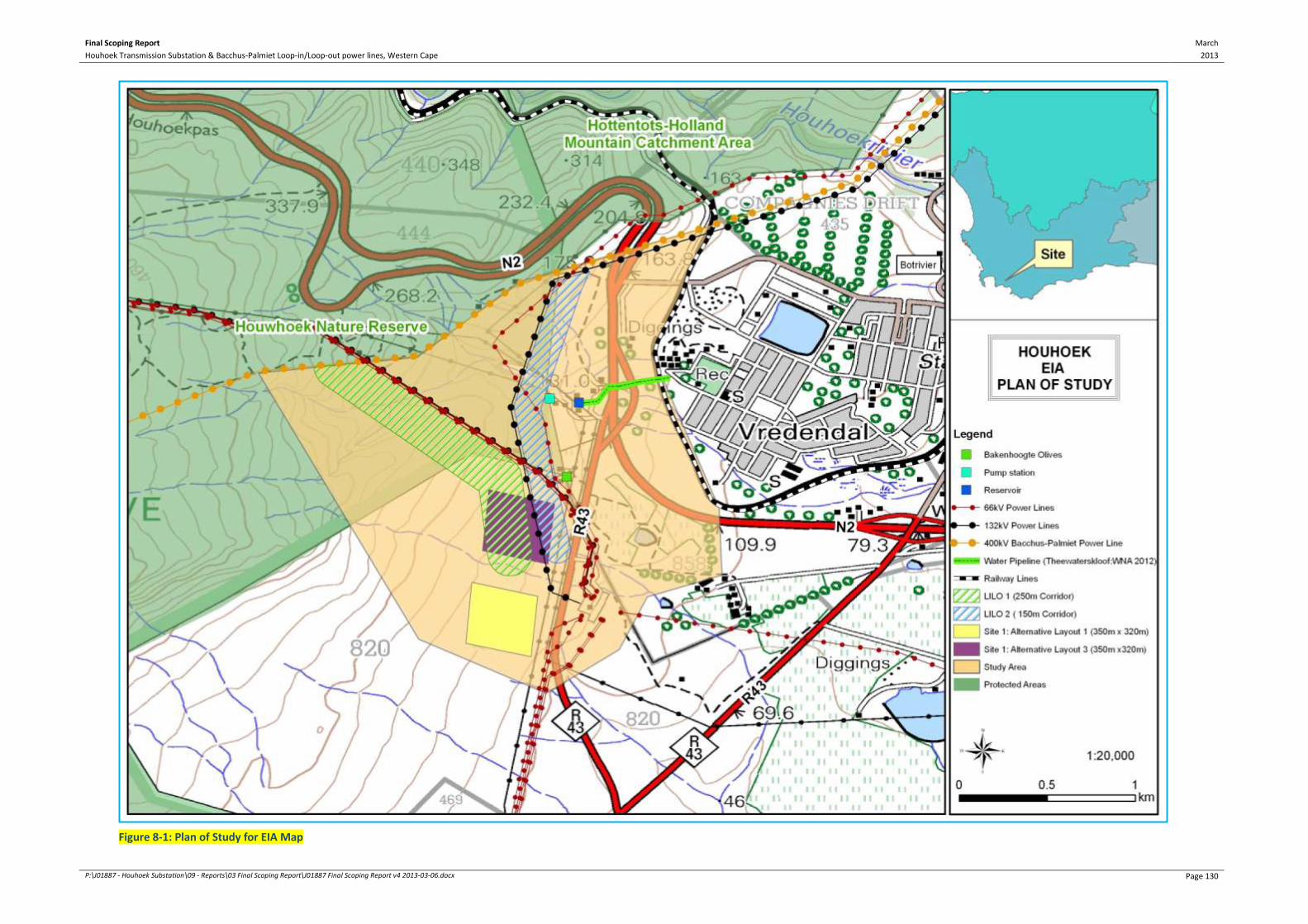
Final Scoping Report March
2013 Houhoek Transmission Substation & Bacchus-Palmiet Loop-in/Loop-out power lines, Western Cape
P:\J01887 - Houhoek Substation\09 - Reports\03 Final Scoping Report\J01887 Final Scoping Report v4 2013-03-06.docx Page 130
Figure 8-1: Plan of Study for EIA Map

Final Scoping Report March
2013 Houhoek Transmission Substation & Bacchus-Palmiet Loop-in/Loop-out power lines, Western Cape
P:\J01887 - Houhoek Substation\09 - Reports\03 Final Scoping Report\J01887 Final Scoping Report v4 2013-03-06.docx Page 131
9 ENVIRONMENTAL IMPACT ASSESSMENT PROCESS
9.1 STUDY APPROACH
The EIA process is a planning and a decision making tool that identifies the potential
negative and positive impacts of the proposed 400kV Transmission substation and associate
infrastructure for the Houhoek Transmission Substation project. It also recommends ways to
enhance the positive impacts and minimise the negative ones.
The environmental studies that will be undertaken will address the impacts associated with
the Houhoek Transmission Substation project and provide an assessment in terms of the
biophysical, social, cultural-historic and economic environments. This will assist the DEA and
Eskom in their decision-making regarding the implementation of the proposed development.
The environmental assessment will be undertaken in compliance with the NEMA, specifically
EIA Regulations (GN R543, 544, 545 and 546 of 18 June 2010, as amended). Cognisance has
also been taken of related guideline documents and other relevant legislation.
The EIA process consists of three phases: the scoping phase, the impact assessment phase
and the decision-making phase. This section outlines the study approach taken to meet the
legislative framework requirements as outlined in Chapter 6 of this report.
9.2 SCOPING PHASE
The aim of the scoping phase of the project is to identify and define the issues that need to
be addressed in the impact assessment phase.
During the Public Participation Process (PPP), the interested and affected parties (I&APs) are
identified and are given the opportunity to identify issues and concerns that are related to
the study area. A first round of public participation has been undertaken as documented in
Section 9.3.
The Draft Scoping Report will be made available to I&APs for review and the Final Scoping
Report will incorporate all comments that have been received before being submitted to the
DEA for consideration.
9.3 PUBLIC PARTICIPATION PROCESS (SCOPING PHASE)
The Public Participation Process (PPP) is an integral requirement of the NEMA. Under the
supervision and guidance of the DEA, BKS recommends the PPP for the Houhoek
Transmission Substation project be in accordance with the requirements of Section 54 of the
EIA Regulations (2010). This is due to the scale, nature and affected footprint of the
Houhoek Transmission Substation project.
The purpose of this initial PPP will be to inform the I&APs about the EIA process to be
followed. This initial interaction with the I&APs would also include requesting their input
into the manner in which the proposed PPP will be conducted.
Final Scoping Report March
2013 Houhoek Transmission Substation & Bacchus-Palmiet Loop-in/Loop-out power lines, Western Cape
P:\J01887 - Houhoek Substation\09 - Reports\03 Final Scoping Report\J01887 Final Scoping Report v4 2013-03-06.docx Page 132
9.3.1 Objectives and General Approach
The main objectives of the PPP are to:
inform identified interested and affected parties (I&APs) of and provide sufficient
background and technical information on the Houhoek Transmission Substation project;
create networks and feedback mechanisms so I&APs could participate and raise their
viewpoints (issues, comments and concerns) on the Houhoek Transmission Substation
project; and
assist in identifying potential environmental (biophysical, cultural-historical, social and
economic) impacts using on-the-ground information through the I&APs’ available
experience.
The PPP thus ensures that I&APs’ views are reflected and considered by the Applicant. The
approach to any PPP depends on the details of the project, as each project has a particular
geographic and technical nature. Thus, the PPP should be structured accordingly. Where
possible, and within the required statutory frameworks, such a process should be structured
to address the needs of project-specific I&APs. All I&APs shall be given an equal opportunity
to comment and raise any issues relating to the impact of the Houhoek Transmission
Substation project on the biophysical, social and economic environment.
9.3.2 Identification and Registration of I&APs on a Database
The following key stakeholders were identified for engagement on any issues that may
transpire during the EIA process:
Landowners and occupiers of land affected by the 3 alternative site locations of the
proposed Houhoek Substation.
Western Cape Department of Environmental Affairs and Development Planning
(DEA&DP), as the commenting authority.
Regional Office of the Department of Water Affairs (DWA).
National Department of Agriculture (DoA).
South African Heritage Resources Agency (SAHRA) and the provincial office, Heritage
Western Cape (HWC).
The South African National Roads Authority Limited (SANRAL).
Western Cape Department of Transport and Public Works.
Theewaterskloof Local Municipality (including Councillors).
Cape Nature.
A database has been compiled and will be updated throughout the EIA process as and when
new stakeholders are identified.
9.3.3 Project Announcement Phase
Phase 1 of the PPP entailed the announcement of the project to the identified key
stakeholders during the designated timeframe. The project was announced on
25 September 2012. Consultations with I&APs and relevant stakeholders were according to
the following methods (see Appendix B for further details):

Final Scoping Report March
2013 Houhoek Transmission Substation & Bacchus-Palmiet Loop-in/Loop-out power lines, Western Cape
P:\J01887 - Houhoek Substation\09 - Reports\03 Final Scoping Report\J01887 Final Scoping Report v4 2013-03-06.docx Page 133
A Background Information Document (BID) was circulated to I&APs and stakeholders
that registered and were identified for registration.
Advertisements were placed in the main section of the following newspapers on
Tuesday, 25 September 2012:
o Cape Times; and
o Theewaterskloof Gazette – English and Afrikaans versions.
106 e-mail notifications, registered mails and faxes (including several phone calls) on
25 September 2012.
Flyers in English and Afrikaans were distributed in the study area.
Site notices were placed at 12 strategic locations (see Appendix B) within the study area.
A public open day has been scheduled for Thursday, 6 December 2012 from 17:00 –
19:00 at the Botrivier Advice & Development Centre (12 Fontein Street, Botrivier).
9.3.4 Draft Scoping Report Review
The purpose of the Draft SR is to enable the registered I&APs to verify that their
contributions have been captured, understood and interpreted correctly. The Draft SR was
available for review by registered I&APs from 29 November 2012 to 25 January 2013.
Advertisements have been placed in the newspapers indicated above to announce the
availability of the Draft SR for review on 22 November 2012.
If I&APs wish to register during this period, they will be allowed to. However, only the
comments and issues raised up to 24 January 2013 will be incorporated in the Final SR, for
submission to the DEA. Comments and issues raised after the end date will be taken into
consideration during the EIA Phase.
I&APs can comment on the Draft SR in various ways, such as completing the comment sheet,
submitting individual comments in writing, by facsimile or by e-mail and through one-on-one
discussions with members of the EIA team during meetings.
Some of the issues identified during the PPP undertaken to date include:
The cumulative impact of the proposed Houhoek Transmission Substation project on the
proposed wind farms in the region and the related Distribution power lines that will link
both infrastructures.
The need for Traffic Impact Assessment study to determine traffic and transport
engineering impacts related to the proposed toll booth on, as well as access to and from
the R43.
The need for a Town Planning Assessment to determine the applicability of the LUPO
process on the proposed Houhoek MTS.
The use of Xhosa translations for future correspondence and consultations with the
public.
The need for this EIA process to consider the existing electrical and road infrastructure
within the study area.

Final Scoping Report March
2013 Houhoek Transmission Substation & Bacchus-Palmiet Loop-in/Loop-out power lines, Western Cape
P:\J01887 - Houhoek Substation\09 - Reports\03 Final Scoping Report\J01887 Final Scoping Report v4 2013-03-06.docx Page 134
9.4 ENVIRONMENTAL IMPACT ASSESSMENT PHASE
The EIA for the Houhoek Transmission Substation project is being conducted in accordance
with the process described in regulation 26 to 35 of the EIA Regulations (GN R543 of 18 June
2010, as amended) promulgated in terms of section 24(5) of the NEMA. BKS is responsible
for the processing and collation of information from the specialist reports, including the
issues raised from the PPP.
9.5 POST ENVIRONMENTAL AUTHORISATION PROCESSES
9.5.1 Servitude Negotiation Process
The PPP undertaken for the EIA does not include the final servitude negotiations with the
landowners that will be directly affected by the final route alignment of the power lines and
the location of the Houhoek Substation. It is important that the aims of the EIA and
servitude negotiation processes are seen as separate. They share a common cause (the
construction and operation of a Transmission power line) and may share common
landowner databases, but they have different aims.
The servitude negotiations task will be undertaken by a negotiator from Eskom, if a positive
environmental authorisation for the project is received. The Eskom negotiator has, however,
been involved in the project team site visit and will be involved in discussions regarding the
selection of a recommended route for the proposed power LILO and the proposed
substation site. An extensive effort is being made to identify and involve all possibly affected
landowners through representative organisations, such as the municipalities and farmers'
organisations and as far as possible, with individual landowners.

Final Scoping Report March
2013 Houhoek Transmission Substation & Bacchus-Palmiet Loop-in/Loop-out power lines, Western Cape
P:\J01887 - Houhoek Substation\09 - Reports\03 Final Scoping Report\J01887 Final Scoping Report v4 2013-03-06.docx Page 135
Source: Eskom Transmission, Gamma-Omega 765kV Transmission Line, Draft Environmental Impact
Report, Main Report, March 2002
Servitude Negotiation and the EIA Process
Transmission power lines are constructed and operated within a servitude (up to 55m wide for
400kV lines) that is established along its entire length. The servitude allows Eskom Transmission
certain rights and controls that support the safe and effective operation of the line. The process
of achieving the servitude agreement is referred to as the Servitude Negotiation Process, or the
negotiation process, and is undertaken by Eskom Transmission. Important points relating to the
EIA process are:
Servitude negotiation is a private matter between Eskom Transmission and the landowner
concerned.
The negotiation process involves a number of stages (see text box below), and culminates in
the signing of a servitude. Here, Eskom Transmission enters into a legal agreement with the
landowner.
The agreements detail aspects such as the exact location and extent of the servitude, access
arrangements and maintenance responsibilities.
Compensation measures are agreed in each case.
It may take place at any time in the planning of a new line.
It must be completed (i.e. the agreement must be signed) before construction starts on that
property.
The servitude negotiation process is independent of the EIA process.
The EIA process has become important in the initial planning and route selection of a new
Transmission power line, and it is preferable that the negotiation process begins after the EIA has
been completed. At this stage, there is greater confidence in the route alignment to be adopted,
and it would be supported by an environmental authorisation.
However, the negotiation process may have to start earlier, and may begin before or run parallel
to the EIA process due to tight timeframes, knowledge of local conditions and constraints, for
example. Eskom Transmission has the right to engage with any landowner at any time, although
it does so at risk if environmental authorisation has not been awarded.

Final Scoping Report March
2013 Houhoek Transmission Substation & Bacchus-Palmiet Loop-in/Loop-out power lines, Western Cape
P:\J01887 - Houhoek Substation\09 - Reports\03 Final Scoping Report\J01887 Final Scoping Report v4 2013-03-06.docx Page 136
Source: Eskom Transmission, Gamma-Omega 765kV Transmission Line, Draft Environmental Impact
Report, Main Report, March 2002
9.5.2 Rezoning Process
The rezoning of properties that the servitude will cross occurs after the servitude has been
negotiated. The rezoning process is independent of this EIA process for the substation site
and the power lines.
The Negotiation Process
The negotiation process can be extensive, and often takes years on the longer lines. It is thus
critical that it is correctly programmed into the planning of a new line. The negotiation process
involves:
Initial meeting with the landowner.
The signing of an option to secure a servitude (indicates that the owner will accept that the
line will cross his property, subject to conditions to be finalised in the negotiation of the
servitude agreement). An option is valid for one year.
Once the route is confirmed (i.e. options signed with the upstream and downstream
landowners) the servitude agreement is finalised with the individual landowners. This
agreement sets out the conditions for the establishment and operation of the servitude, and
is site specific (different landowners may have different requirements). Compensation
payments are made when the servitude is registered at the Deeds office.
Once construction is complete and the land is rehabilitated to the landowner’s satisfaction,
the landowner signs a Final Release certificate. Until such time, Eskom Transmission remains
liable for the condition of the land.
Once the clearance certificate is signed, the responsibility for the line and servitude is
handed over to the regional Eskom Transmission office. Prior to this, the Eskom national
office is responsible for the process.

Final Scoping Report March
2013 Houhoek Transmission Substation & Bacchus-Palmiet Loop-in/Loop-out power lines, Western Cape
P:\J01887 - Houhoek Substation\09 - Reports\03 Final Scoping Report\J01887 Final Scoping Report v4 2013-03-06.docx Page 137
10 PLAN OF STUDY FOR THE EIA PHASE
A Plan of Study for the EIA has been prepared according to the process described in
regulations 26-35 of the EIA Regulations (GN R543 of 18 June 2010, as amended)
promulgated in terms of Section 24(5) of the NEMA, to provide the DEA with adequate
information to obtain authorisation, and proceed with the proposed activity.
The Plan of Study for EIA includes a description of the environmental issues that have been
identified during the Scoping phase and which will require further investigation and
assessment.
10.1 METHODOLOGY OF SPECIALIST STUDIES
The specialist studies will be undertaken in compliance with regulation 32(3) of the EIA
Regulations (GN R543 of 18 June 2010, as amended), and include:
a. details of:
i. the person who prepared the report; and
ii. the expertise of that person to carry out the specialist study or specialised process;
b. a signed declaration that the person is independent in a form as may be specified by the
competent authority;
c. an indication of the scope of, and the purpose for which, the report was prepared;
d. a description of the methodology adopted in preparing the report or carrying out the
specialised process;
e. a description of any assumptions made and any uncertainties or gaps in knowledge;
f. a description of the findings and potential implications of such findings on the impact of
the proposed activity, including identified alternatives, on the environment;
g. recommendations in respect of any mitigation measures that should be considered by
the Applicant and the competent authority;
h. a description of any consultation process that was undertaken during the course of
carrying out the study;
i. a summary and copies of any comments that were received during any consultation
process; and
j. any other information requested by the competent authority.
The following specialist studies will be undertaken for the EIA Phase:
Geotechnical Assessment by Dirk van Rooyen (Geotechnics Africa).
Soil and Agricultural Potential Assessment by Garry Paterson (Institute of Soil, Climate
and Water of the Agricultural Research Council).
Freshwater Ecosystems Assessment (including wetlands, dams and rivers) by Dean Ollis
(The Freshwater Consulting Group).
Ecological Assessment by Nick Helme (Nick Helme Botanical Surveys).
Avifauna Assessment by Chris van Rooyen (Chris van Rooyen Consulting).
Social Impact Assessment by Ingrid Snyman (Ingrid Snyman Development Consultants).
Visual Assessment by Stephen Stead (VRM Africa).
Heritage Assessment by Tim Hart (Archaeological Contracts Office, University of Cape
Town).

Final Scoping Report March
2013 Houhoek Transmission Substation & Bacchus-Palmiet Loop-in/Loop-out power lines, Western Cape
P:\J01887 - Houhoek Substation\09 - Reports\03 Final Scoping Report\J01887 Final Scoping Report v4 2013-03-06.docx Page 138
Traffic Assessment by Colin Tichauer (AECOM SA).
Town Planning Assessment by Nina Otto (AECOM SA).

Final Scoping Report March
2013 Houhoek Transmission Substation & Bacchus-Palmiet Loop-in/Loop-out power lines, Western Cape
P:\J01887 - Houhoek Substation\09 - Reports\03 Final Scoping Report\J01887 Final Scoping Report v4 2013-03-06.docx Page 139
Figure 10-1: Plan of Study for EIA Map

Final Scoping Report March
2013 Houhoek Transmission Substation & Bacchus-Palmiet Loop-in/Loop-out power lines, Western Cape
P:\J01887 - Houhoek Substation\09 - Reports\03 Final Scoping Report\J01887 Final Scoping Report v4 2013-03-06.docx Page 140
10.1.1 Terms of Reference: Geotechnical Investigation
A Geotechnical Investigation will be undertaken by Mr Dirk van Rooyen of Geotechnics
Africa Western Cape. The methodology of the Geotechnical Investigation used for this
process is described in this section.
The purpose of the investigation will be to provide technical advice on:
The expected bedrock geology and soil cover within the study area, based on the
available data.
Recommendations on the foundation trench stability, founding masts and poles, and
seismicity.
Information on excavation potential together with the presence of active soil layers and
any slope stability problems.
The nature of the investigation will entail:
Investigation of the available information and the interpretation off the Google Earth
images from the study area.
Site visit to assess the broad study area, surface conditions and an inspection of existing
excavations on and surrounding the alternative sites.
Photographs will be taken of relevant surface features.
10.1.2 Terms of Reference: Soil and Agricultural Potential Assessment
The Soil and Agricultural Potential Assessment will be undertaken by Mr Garry Paterson of
the Agricultural Research Council. The methodology of the Soil & Agricultural Potential
Assessment for this process is described in this section.
The 1:50,000 scale soil map will be analysed to determine the soil information for the study
area. The soils are then classified according to the South African Soil Classification System.
The classification of the different soils would represent the dominant soil within the specific
land type that is identified.
On-site verification of the specifics of the various alternatives and their layout alternatives
will be carried out by the specialists; this information will be confirmed from other sources
and will be linked in to the data gathered.
Due to the fact that no high potential agricultural soils were identified at this stage of the
investigation, as well as the fact that no arable agriculture is taking place on any of the three
alternative sites, it was decided that no soil samples would be collected for analysis at this
stage.
The soil information will be considered in terms of the agricultural potential, specifically in
terms of the existing agricultural land-uses in the wider area, and the potential lost will be
considered in the final specialist report.
This information will then be plotted on a GIS format map and integrated into the EIA
Report.

Final Scoping Report March
2013 Houhoek Transmission Substation & Bacchus-Palmiet Loop-in/Loop-out power lines, Western Cape
P:\J01887 - Houhoek Substation\09 - Reports\03 Final Scoping Report\J01887 Final Scoping Report v4 2013-03-06.docx Page 141
10.1.3 Terms of Reference: Freshwater Ecosystems Assessment
The Freshwater Ecosystems Assessment will be undertaken by Mr Dean Ollis of the
Freshwater Consulting Group. The methodology of the Freshwater Ecosystems Assessment
for this process is described in this section.
A wetland sensitivity map has been, compiled with the following scope, for input into the
Draft SR and provides the baseline conditions for the Freshwater Ecosystems Assessment
during the EIA phase:
The boundary of the study area (‘corridor’ as referred to in Figure 3-5) and the proposed
substation layouts will be overlaid as GIS shapefiles onto existing geo-referenced
1:10,000 scale aerial photographs of the area obtained from Chief Directorate: National
Geo-spatial Information.
Currently mapped rivers (perennial and non-perennial), as shown on the 1:50,000 scale
digital map layer for rivers obtained from Chief Directorate: National Geo-spatial
Information (map sheet 3419AA), will be overlaid onto the GIS map. A 50m wide ‘no-go’
buffer zone will be allocated to rivers in the study area that fall within a Protected Area
(e.g. a formal nature reserve) or a terrestrial Critical Biodiversity Area (CBA), according
to the Overberg CBA Map (Holness & Bradshaw, 2010)5.
Currently mapped dams, as shown on the 1:50 000 scale digital map layer for ‘Inland
Water Areas’ obtained from Chief Directorate: National Geo-spatial Information (map
sheet 3419AA), will be overlaid onto the GIS map.
Wetlands mapped by the NFEPA project will be overlaid onto the GIS map of the area.
Two categories will be distinguished in the map legend, namely FEPA wetlands and non-
priority wetlands. Following (Driver, et al., 2011), a 100m wide ‘no go’ buffer zone will
be allocated to all FEPA wetlands in the study area.
Critical Biodiversity Areas and Protected Areas, as shown on the CBA map for the ODM
(Holness & Bradshaw, 2010), were intersected with the existing wetlands layer for the
Overberg (mapped by Nancy Job as part of the CAPE Fine-Scale Biodiversity Planning
project) in order to identify wetlands occurring in areas of high conservation
importance, thus warranting specific protection. A 50m wide ‘no-go’ buffer zone will be
allocated to these wetlands, given their ecological importance.
Recent colour aerial photographs (from Chief Directorate: National Geo-spatial
Information) and Google Earth satellite images of the site will be examined, to ascertain
whether any visible signs of wetland presence could be discernible in the study area.
Additional aquatic ecosystems in the study area will be manually digitised using GIS
software, based on visual cues in the background imagery.
The study area for the proposed LILO power lines and the development footprint of each
of the proposed substation sites will be overlaid onto the GIS map.
5 Most of the land within the study area is categorised as a Protected Area or terrestrial CBA on the Overberg CBA Map

Final Scoping Report March
2013 Houhoek Transmission Substation & Bacchus-Palmiet Loop-in/Loop-out power lines, Western Cape
P:\J01887 - Houhoek Substation\09 - Reports\03 Final Scoping Report\J01887 Final Scoping Report v4 2013-03-06.docx Page 142
The Freshwater Ecosystems Assessment will be undertaken based on the following terms of
reference:
Conduct a desktop assessment to identify and map the freshwater ecosystems that are
likely to be present on site, based on examination of existing 1:50,000 topographical
maps, colour aerial photographs, satellite imagery and fine-scale conservation plans.
Field-based assessment of the proposed LILO power line route alignments to confirm
whether there are any freshwater ecosystems located along the proposed routes.
Ground-truth and update the desktop-based map of freshwater ecosystems, based on
the information obtained during the site visit.
Collection of sufficient information / data to determine the present ecological condition
and conservation importance of potentially affected freshwater ecosystems. The habitat
value of the potentially affected freshwater ecosystems will be investigated and
reported on.
Refinement of recommended buffer areas for protection of freshwater ecosystems.
Formal assessment of the significance of potential impacts and the potential cumulative
impacts on freshwater ecosystems, using appropriate criteria.
Recommendation of specific mitigation measures for the protection of freshwater
ecosystems, which could be incorporated into the EMPr.
The following aspects will not be included in the Freshwater Ecosystems Assessment, for the
corresponding reasons:
Water Quality (surface and groundwater): As most of the potentially affected
freshwater ecosystem are seasonal, being dry during the summer season when the
fieldwork was for the Scoping Phase (and will be for EIA Phase) to be undertaken, it was
not (and is not going to be) possible to collect water quality data. The water quality of
the natural systems can, however, be inferred to a large degree on the basis of the
surrounding land-use and on an assessment of the habitat integrity of the systems – this
will be done during the EIA phase. The implementation of appropriate mitigation
measures to minimise the risk of water quality impacts during the construction phase of
the project should ensure proper protection of freshwater ecosystems from such
impacts, regardless of the baseline situation in terms of present-day water quality. It is
also important to note that it is not really possible to establish the baseline situation
with regard to the water quality of a freshwater ecosystem on the basis of once-off
sampling (long-term monitoring data are generally needed to establish the typical
baseline conditions).
Hydrochemistry (organic, inorganic, physical): Based on the understanding of the
potential impacts on freshwater ecosystems that could be associated with the proposed
project, water quality impacts are not one of the key issues of concern. For example,
construction activities would not necessarily result in increased turbidity and TDS in
aquatic ecosystems because the site for the substation may not end up being located in
close vicinity to any freshwater ecosystems. Furthermore, with proper construction-
phase mitigation measures in place, and included in the EMPr for the project, most
potential water quality impacts can be quite easily avoided.

Final Scoping Report March
2013 Houhoek Transmission Substation & Bacchus-Palmiet Loop-in/Loop-out power lines, Western Cape
P:\J01887 - Houhoek Substation\09 - Reports\03 Final Scoping Report\J01887 Final Scoping Report v4 2013-03-06.docx Page 143
Refer to Chapter 10.2 for broad development guidelines, which should be taken into
consideration for the planning stages of the project to ensure the protection of freshwater
ecosystems that could be affected by the proposed Houhoek MTS project.
10.1.4 Terms of Reference: Ecological Assessment
The Ecological Assessment will be undertaken by Mr Nick Helme of Nick Helme Botanical
Surveys. The methodology of the Ecological Assessment for this process is described in this
section.
The following standard terms of reference for biodiversity specialists will be as
recommended by Cape Nature, and includes:
Produce a baseline analysis of the ecological attributes (vegetation and terrestrial fauna
only) of the study areas as a whole. This baseline analysis was completed and included in
this Scoping Report. The ecological attributes of Site 1 layout alternatives and LILO Route
Corridor alternatives will be analysed in more detail during the EIA phase.
This report should clearly indicate any constraints that would need to be taken into
account in considering the development proposals further.
This report must include a map of the identified ecologically sensitive areas as well as
indications of important constraints on the property. It must also:
o Describe the broad ecological characteristics of the site and its surrounds in terms of
any mapped spatial components of ecological processes and/or patchiness,
patch size, relative isolation of patches, connectivity, corridors, disturbance regimes,
ecotones, buffering, viability, etc.
o In terms of biodiversity pattern, identify or describe:
Community and ecosystem level
− The main vegetation type, its aerial extent and interaction with neighbouring
types, soils or topography.
− The types of plant communities that occur in the vicinity of the site.
− Threatened or vulnerable ecosystems (cf. DEA 2011/SA vegetation map/National
Spatial Biodiversity Assessment, etc.).
Species level
− Plant and terrestrial faunal Species of Conservation Concern (SCC) – provide
location if possible.
− The viability and estimated population size of the SCC that are present (include
the degree of confidence in prediction based on availability of information and
specialist knowledge, i.e. High=70-100% confident, Medium 40-70% confident,
low 0-40% confident).
− The likelihood of other SCC occurring on the site (include degree of confidence).
Final Scoping Report March
2013 Houhoek Transmission Substation & Bacchus-Palmiet Loop-in/Loop-out power lines, Western Cape
P:\J01887 - Houhoek Substation\09 - Reports\03 Final Scoping Report\J01887 Final Scoping Report v4 2013-03-06.docx Page 144
Other pattern issues
− Any significant landscape features or rare or important vegetation associations
such as seasonal wetlands, alluvium, seeps, quartz patches or salt marshes in the
vicinity.
− The extent of alien plant cover of the site, and whether the infestation is the
result of prior soil disturbance such as ploughing or quarrying (alien cover
resulting from disturbance is generally more difficult to restore than infestation
of undisturbed sites).
− The condition of the site in terms of current or previous land uses.
o In terms of biodiversity process, identify or describe:
− The key ecological “drivers” of ecosystems on the site and in the vicinity, such as
fire.
− Any mapped spatial component of an ecological process that may occur at the
site or in its vicinity (i.e. “corridors” such as watercourses, upland-lowland
gradients, migration routes, coastal linkages or inland-trending dunes, and
“vegetation boundaries” such as edaphic interfaces, upland-lowland interfaces
or biome boundaries).
− Any possible changes in key processes, e.g. increased fire frequency or
drainage / artificial recharge of aquatic systems.
What is the significance of the potential impact of the Houhoek Transmission Substation
project – with and without mitigation – on biodiversity pattern and process at the site,
landscape, and regional scales?
Provide a map, at suitable scale, of key conservation areas and corridors.
Recommend actions that should be taken to prevent or mitigate impacts. Indicate how
these should be scheduled to ensure long-term protection, management and restoration
of affected ecosystems and biodiversity.
Indicate limitations and assumptions, particularly in relation to seasonality.
The avifauna (Chapter 10.1.5) and wetland (Chapter 10.1.3) components to biodiversity
were excluded from the Ecological Assessment as these components are covered in these
respective specialist studies.
10.1.5 Terms of Reference: Avifauna Assessment
The Avifauna Assessment will be undertaken by Mr Chris van Rooyen of Chris van Rooyen
Consulting. The methodology of the Avifauna Assessment for this process is described in this
section.
The following information sources will be consulted to conduct the Avifauna Assessment:
Bird distribution data of the Southern African Bird Atlas Project 2 (SABAP2) will be
obtained for the QDGC (the equivalent of a 1:50 000 topo-cadastral map) where the
proposed infrastructure is located, namely 3419AA.

Final Scoping Report March
2013 Houhoek Transmission Substation & Bacchus-Palmiet Loop-in/Loop-out power lines, Western Cape
P:\J01887 - Houhoek Substation\09 - Reports\03 Final Scoping Report\J01887 Final Scoping Report v4 2013-03-06.docx Page 145
The conservation status of all species considered likely to occur in the area will be
determined as per the most recent iteration of the southern African Red Data list for
birds (Barnes, 2000), and the most recent and comprehensive summary of southern
African bird biology (Hockey, et al., 2005).
The author has travelled and worked extensively on power line projects in the Western
Cape Province since 1996, and since 2010, also on renewable energy projects, including
the proposed Langhoogte wind energy facility, which is situated approximately 7km east
of the current study area. Personal observations of avifauna and bird/habitat
associations will therefore also be used to supplement the data that is available from
SABAP2.
The power line bird mortality incident database of the Eskom - Endangered Wildlife
Trust Strategic Partnership (1996 to 2007) will be consulted to determine which of the
species occurring in the study area are typically impacted upon by power lines and the
extent to which they are impacted on.
A classification of the vegetation types in the 3419AA QDGC will be obtained from the
Southern African Bird Atlas Project 1 (SABAP1, (Harrison, et al., 1997), and the
Vegetation Map of South Africa (Mucina & Rutherford, 2006).
Information on the micro habitat level will be obtained through visiting the area and
obtaining a first-hand perspective. Micro habitats will be identified using a combination
of ornithological and ecological experience of avifaunal/habitat associations in the
region.
Rob Martin, local bird expert with 40 years’ experience of birding in the Western Cape,
will be consulted on the habitat requirements of specific Red Data species recorded in
3419AA, and to obtain the location of existing raptor nests in the vicinity of the study
area.
The priority avifauna that could potentially be affected by the wind farm developments in
the region (particularly the Red Data Blue Crane, Denham’s Bustard and various Red Data
and non-Red Data raptors) are either unlikely to occur regularly in the study area or, if they
do occur (mostly raptors) are unlikely to be significantly impacted by the proposed
development.
10.1.6 Terms of Reference: Social Impact Assessment
The Social Impact Assessment (SIA) will be undertaken by Mrs Ingrid Snyman of Ingrid
Snyman Development Consultants. The methodology of the SIA is described in this section. A
SIA is described as the “…systematic analysis in advance of the likely impacts a development
event (or project) will have on the day-to-day life (environmental) of persons and
communities” (Burdge, 1995). An SIA, therefore, tries to predict the probable impacts of a
development on how people live, work and play by:
Appraising the social impacts resulting from the Houhoek Transmission Substation
project.
Relating the assessed social impacts of the project to future changes in the socio-
economic environments that are not associated with it. This would serve to place the
impacts of the project into context.

Final Scoping Report March
2013 Houhoek Transmission Substation & Bacchus-Palmiet Loop-in/Loop-out power lines, Western Cape
P:\J01887 - Houhoek Substation\09 - Reports\03 Final Scoping Report\J01887 Final Scoping Report v4 2013-03-06.docx Page 146
Using the measurements (rating) to decide whether the impacts would be negative,
neutral or positive.
Determining the significance of the impacts.
Proposing mitigation measures.
A SIA is thus concerned with the human dimensions of the environment, as it aims to
balance social, economic and environmental objectives and seeks to predict, anticipate and
understand the potential impacts of development.
The usefulness of an SIA as a planning tool is clear. An SIA can help the project proponent to
conceptualise and implement a project in a manner which would see the identified negative
social impacts addressed through avoidance or mitigation and the positive impacts
optimised. It would also allow the community to plan for and deal with the social changes
once they come into effect. In this sense then, the SIA is an indispensable part of the EIA and
EMPr.
The aim of the SIA report is to:
Determine the current socio-economic status of the area and the social characteristics of
the receiving environment.
Indicate the anticipated core impact categories and impact areas (possible hot spots).
Identify anticipated positive socio-economic impacts of the Houhoek Transmission
Substation project, including positive impacts and provide management measures for
these impacts.
Identify and highlight negative social impacts (social hot spots) of the Houhoek
Transmission Substation project and indicate mitigation measures to deal with these
impacts.
Present the findings, recommendations and conclusions of the social study.
For the purpose of assessing the impacts associated with the Houhoek Transmission
Substation project, the variables listed below will be adapted during the EIA phase. These
variables would relate to the construction and operational phases of the Houhoek
Transmission Substation project. The following variables will be assessed as part of the SIA
(Burdge, 1995):
Population impacts
Community/institutional arrangements.
Conflicts between local residents and newcomers.
Individual and Family level impacts.
Community infrastructure needs.
Intrusion impacts
During the EIA phase, the anticipated social impacts would be rated according to a specific
rating approach which would include the extent of the impact, the likelihood of the impact
occurring, the size, the duration of the impact and its significance.

Final Scoping Report March
2013 Houhoek Transmission Substation & Bacchus-Palmiet Loop-in/Loop-out power lines, Western Cape
P:\J01887 - Houhoek Substation\09 - Reports\03 Final Scoping Report\J01887 Final Scoping Report v4 2013-03-06.docx Page 147
The SIA Report will comprise the following:
Details of the site visit conducted.
Further literature review: A comprehensive literature review and analysis should be
undertaken during the EIA phase of the project. This would help the consultants to get
further demographic and socio-economic information about the receiving environment
and to build on the initial profiling of the local population’s socio-economic
characteristics.
Consultation sessions and fieldwork: During the EIA phase, more primary data would
also be gathered through consultation with the stakeholders and affected parties, and
linkages with the public participation process.
Analysis of data compiled from parallel studies: If available, the SIA team will study and
analyse the information gathered by the biophysical studies. This information would
include technical, environmental, economic and demographic aspects, land-use changes,
impact on other facilities, services, and so forth. The SIA will be done in parallel with the
public participation process. This would help the social team to assess the impact of the
Houhoek Transmission Substation project on the direct (surrounding communities) and
indirect (regional) environment.
Additional data: Additional data with regards to the construction phase would be
sourced from Eskom. This would include the different timeframes for the construction of
the proposed Houhoek MTS, the 132kV power line and the 400kV LILO power line. It
would also be important to determine the number of workers that would be present in
the area during the general and peak construction timeframes. A breakdown of the skills
required would be provided (if available from client) to determine how the local job
skills match the requirements of the project.
Additional data: If more information with regards to the current and future power
demand in the Western Cape become available from Eskom, an analysis could be
conducted with regards to this project’s macro socio-economic role in this regard.
The SIA Report will include:
A background description of the social environment including demographic and socio-
economic characteristics, land-use profile and infrastructure requirements.
A background description of the local economy.
Linkages with the integrated development planning processes in the area.
An assessment of the anticipated social impacts – negative and positive (including core
aspects needing attention).
Rating of impacts.
Formulation of specific mitigating strategies to minimise negative social impacts and
increase positive impacts of the Houhoek Transmission Substation project.
Conclusions and recommendations (also for further studies, if necessary).

Final Scoping Report March
2013 Houhoek Transmission Substation & Bacchus-Palmiet Loop-in/Loop-out power lines, Western Cape
P:\J01887 - Houhoek Substation\09 - Reports\03 Final Scoping Report\J01887 Final Scoping Report v4 2013-03-06.docx Page 148
10.1.7 Terms of Reference: Town Planning Assessment
All the proposed site alternatives fall within the Integrated Zoning Scheme Regulations
(2011) of the TLM, and would have to be rezoned to “Authority” zoning and “Utility” use as a
primary use for the proposed Houhoek MTS project. The exact process to be followed will be
highlighted in the EIA phase.
10.1.8 Terms of Reference: Visual Impact Assessment
The Visual Impact Assessment (VIA) will be undertaken by Mr Stephen Stead of VRM Africa.
The methodology of the VIA is described in this section.
The process that VRM Africa follows when undertaking a VIA is based on the United States
Bureau of Land Management‘s (BLM) Visual Resource Management method (Figure 10-2).
This mapping and GIS-based method of assessing landscape modifications allows for
increased objectivity and consistency by using a standard assessment criteria and involves
the measurement of contrast in the form, line, texture and colour of the proposed landscape
modification brought about by a project, against the same elements found in the existing
natural landscape.
The first step in the VIA process is determining the existing landscape context. A regional
landscape survey is undertaken, which identifies defining landscape features that surround
the site of a Houhoek Transmission Substation project, and sets the scene for the VIA
process to follow. These features, also referred to as visual issues, are assessed for their
scenic quality/ worth. A VIA also assesses to what degree people, who make use of these
locations (e.g. a nearby holiday resort), would be sensitive to change(s) in their views,
brought about by a Houhoek Transmission Substation project (e.g. a mine). (Assessment
undertaken up to this point falls within the ambit of the field study.)
These people are referred to as receptors and are identified early on in the VIA process. Only
those sensitive receptors who qualify as Key Observation Points (KOPs) by applying certain
criteria, are used to measure the amount of contrast generated by changes caused by
project activities, against the existing landscape (i.e. visual impact).

Final Scoping Report March
2013 Houhoek Transmission Substation & Bacchus-Palmiet Loop-in/Loop-out power lines, Western Cape
P:\J01887 - Houhoek Substation\09 - Reports\03 Final Scoping Report\J01887 Final Scoping Report v4 2013-03-06.docx Page 149
Figure 10-2: VRM Africa’s Process Diagram
The landscape character of the Houhoek Transmission Substation project site is then
surveyed to identify areas of similar land use and landscape character. These areas are
evaluated in terms of scenic quality (landscape significance) and receptor sensitivity to
landscape change (of the site) in order to define the visual objective for the project site. The
overall objective is to maintain a landscape’s integrity, but this can be achieved at varying
levels, called VRM Classes, depending on various factors, including the visual absorption
capacity of a site (i.e., how much of the project would be “absorbed” or “disappear”, into
the landscape). The areas identified on site are categorised into these Classes by using a
matrix developed by BLM Visual Resource Management, which is then represented in a
visual sensitivity map.
Landscapes are sub-divided into 3 distance zones based on relative visibility from travel
routes or observation points. Proximity to surrounding receptors is evaluated in terms of
these distance buffers: foreground zone is less than 6km, background zone is from 6 to
24km, and seldom seen has no receptors. Viewshed maps are generated that indicate the
overall area where the project activities would be visible, and in which distance buffer zone
the receptors fall.
The Houhoek Transmission Substation project activities are then finally assessed from the
KOPs around the site to see whether the visual objectives (VRM Classes) defined for the site,
are met in terms of measuring the potential change to the site’s form, line, colour and
texture visual elements, as a result of the Houhoek Transmission Substation project (i.e. are
the expected changes within acceptable parameters to ensure that the visual character of

Final Scoping Report March
2013 Houhoek Transmission Substation & Bacchus-Palmiet Loop-in/Loop-out power lines, Western Cape
P:\J01887 - Houhoek Substation\09 - Reports\03 Final Scoping Report\J01887 Final Scoping Report v4 2013-03-06.docx Page 150
the landscape is kept intact and, if not, what can be done by the project to ensure that it is).
Photo montages are generated to represent the expected change in the views, as seen from
each KOP and, if class objectives are not met, to also show how proposed mitigation
measures could improve the same views.
Using the impact assessment method provided by the environmental consultant, each
project activity is then assessed for its visual impact. This is based on the contrast rating
which was undertaken from each of the surrounding receptors on whether the proposed
activities meet the recommended visual objectives defined, to protect the landscape
character of the area. Recommendations are made and mitigations are provided.
It is reaffirmed that a VIA will be undertaken to address the potential change to the
landscape character. The following receptor points need to be included in the impact
assessment as the proposed project is located in their close proximity and the potential
exists for a change in landscape character.
Houwhoek Nature Reserve.
Adjacent farmsteads and tourist destinations i.e. the Bakenhoogte olive farm.
The town of Botrivier.
Travellers along the R43.
Travellers along the N2.
The following issues will be considered in further studies on the project:
Impact Assessment: The substation and power lines will be assessed in terms of the
potential visual impact they could have on the surrounding sense of place and landscape
character.
Cumulative Impacts: A cumulative impact, in relation to an activity, is the impact of an
activity that may not be significant but may become significant when added to the
existing and potential impacts arising from similar or other activities in the area. The
possible cumulative impacts of this project will be considered as much as possible.
10.1.9 Terms of Reference: Heritage Impact Assessment
The Heritage Impact Assessment (HIA) will be undertaken by Mr Tim Hart from
Archaeological Contracts Office of the University of Cape Town. The methodology of the HIA
is described in this section.
Indications during the scoping phase are that impacts to palaeontological and archaeological
heritage will be of low significance. However, the impacts of the proposed activities in terms
of the aesthetics of the area are of concern. It is thus recommended that:
The proposed alternative substation sites will be subject to a site inspection by an
archaeologist.
Historic places, buildings and features need to be identified and assessed in terms of the
possible changes to their context and setting.

Final Scoping Report March
2013 Houhoek Transmission Substation & Bacchus-Palmiet Loop-in/Loop-out power lines, Western Cape
P:\J01887 - Houhoek Substation\09 - Reports\03 Final Scoping Report\J01887 Final Scoping Report v4 2013-03-06.docx Page 151
10.1.10 Terms of Reference: Traffic Impact Assessment
The Traffic Impact Assessment (TIA) will be undertaken by Mr Colin Tichauer from
AECOM SA (Pty) Ltd. The methodology of the TIA is described in this section.
The DoT was already approached during the Scoping Phase to obtain information relating to
the widening of the R43 and the upgrade/tolling of the N2. During the EIA phase, the future
road network improvement planning will be assessed as per the assessment methodology
for the EIA process (Chapter 10.3).
10.2 TECHNICAL SPECIALISTS WORKSHOP
A Technical Specialists Workshop is planned after all the specialists’ detailed studies for Site
Alternative 1 layouts 1 and 2 and LILO Route Corridors 1 and 2 have been completed, and
after the DEA has submitted its comments on the Final SR. The Workshop should also be
held prior to the finalisation of the EMPr so that site-specific mitigation measures can be
included by the specialists in their reports, which will be extracted by the EAP into the EMPr.
The purpose of the Technical Specialists Workshop is to weigh the specialists’ findings
according to sensitivity and integrate the findings of all specialist studies to determine which
site layout alternative, LILO Transmission route alignment, and, Distribution power line
connections to the existing Houhoek substation should be recommended for development
and whereon the site-specific EMPr should be based.
Each specialist will assign a significance impact rating to each alternative layout and LILO
Route Corridor for the Houhoek Substation project, based on their assessments.
The following factors will also be taken into account in allocating a significance impact rating
to the proposed infrastructure:
The following ecologically-sensitive areas would be avoided, as far as practically
possible:
o Wetlands and stormwater dams.
o Rivers and their floodplains.
o Critical Biodiversity Areas (CBAs).
o Nature Reserves.
Specific criteria for freshwater ecosystems:
o Encroachment into freshwater ecosystems and their recommended buffer areas
should be avoided as far as possible.
o Where the crossing of rivers by infrastructure such as roads is necessary, this should
be located at existing road crossings as far as possible.
o Land that has already been substantially disturbed and/or transformed from its
natural state (e.g. through long-term farming activities or prior infilling) should be
targeted for the establishment of structures and infrastructure associated with the
proposed development, as far as possible, because this would lower the risk of
impacting on freshwater ecosystems that are in a good present ecological condition.

Final Scoping Report March
2013 Houhoek Transmission Substation & Bacchus-Palmiet Loop-in/Loop-out power lines, Western Cape
P:\J01887 - Houhoek Substation\09 - Reports\03 Final Scoping Report\J01887 Final Scoping Report v4 2013-03-06.docx Page 152
o Effective measures should be designed for the management of stormwater runoff
from the substation and other hardened surfaces (including new roads), so as to
minimise the hydrological changes to freshwater ecosystems in the study area as far
as possible.
o Provision should be made for the establishment of ecological corridors through the
study area, which should be located and designed through a consultative process
including all the biophysical specialists involved in the environmental assessment for
the project.
Existing power lines:
o Other Eskom Transmission and Distribution power lines running parallel to a
proposed alignment could be treated as a risk-reducing factor, or if the visual aspect
is considered significant enough, should be treated as a high risk factor (to avoid
cluttering of power lines together).
o Existing power lines have to be crossed as perpendicular as possible and as close as
possible to the lowest height between existing pylon towers (i.e. where the line sag
is the lowest).
o Due to the steep terrain for the LILO Route Corridors, only self-supporting towers
can be used on this project. In addition, the span between towers will also be less
than for towers on flatter terrain.
Towns and industrial activity:
o These are centres of human activity and are generally avoided by large power line
sensitive bird species.
o The presence of towns, settlements and industrial activity is therefore a
risk-reducing factor from a bird collision, disturbance and habitat destruction
perspective.
o Formal and informal settlements, commercial and industrial activities need to be
avoided, as far as practically possible.
Agricultural lands and vineyards:
o The integral value of vineyards and certain agricultural properties cannot be
discarded as there could be a loss of production within its respective industry.
o Consideration will also be carried out of existing vs. potential future agricultural
potential of the proposed Site Alternatives being considered.
The significance impact ratings ascribed will be used as a basis to determine the
recommended site for the Houhoek Substation and the recommended route alignment for
the LILO Transmission Route Corridor and Distribution power line.
Through Eskom’s technical inputs, and the inputs of the various specialists, the
recommended site alternative for the Houhoek Substation and the recommended route
alignment for the LILO Transmission and Distribution power lines will be optimally
positioned to avoid impacts, where practically possible.

Final Scoping Report March
2013 Houhoek Transmission Substation & Bacchus-Palmiet Loop-in/Loop-out power lines, Western Cape
P:\J01887 - Houhoek Substation\09 - Reports\03 Final Scoping Report\J01887 Final Scoping Report v4 2013-03-06.docx Page 153
10.3 ASSESSMENT METHODOLOGY
10.3.1 Impact Assessment Criteria
The criteria used for the assessment of the potential impacts of the Houhoek Transmission
Substation project are described in Table 10-1. In addition, cumulative impacts will be
included as part of the Impact Assessment Process.
Table 10-1: Impact Assessment Criteria
Criteria Description
Nature Includes a description of what causes the effect, what will be affected and how it will be affected.
Extent Physical and spatial scale of the impact.
Duration Lifetime of the impact is measured in relation to the lifetime of the Houhoek Transmission
Substation project.
Intensity Examining whether the impact is destructive or benign, whether it destroys the impacted
environment, alters its functioning, or slightly alters the environment.
Probability This describes the likelihood of the impacts actually occurring. The impact may occur for any length
of time during the lifecycle of the activity, and not at any given time.
Status Description of the impact as positive, negative or neutral, and direct or indirect.
Significance
Synthesis of the characteristics described above and assessed as low, medium or high. Distinction
will be made for the significance rating without the implementation of mitigation measures and
with the implementation of mitigation measures.
10.3.2 Extent
The physical and spatial scale of the impact is classified below.
Description Explanation Scoring
Footprint Impacted area extends only as far as the activity, such as footprint occurring within
the total site area. 1
Site Impact could affect the whole, or a significant portion of the site. 2
Regional Impact could affect the area around the site including neighbouring farms, transport
routes and adjoining towns. 3
National Impact could have an effect that expands throughout the country (South Africa (SA)). 4
International Impact has international ramifications that go beyond the boundaries of SA 5
10.3.3 Duration
The lifetime of the impact is measured in relation to the lifetime of the Houhoek
Transmission Substation project, as shown in the following table.
Description Explanation Scoring
Short term Impact will either disappear with mitigation or will be mitigated through a natural
process in a period shorter than any of the development phases. 1
Short to
medium term Impact will be relevant through to the end of the construction phase 2
Medium term Impact will last up to the end of the development phases, where after it will be
entirely negated. 3
Long term Impact will continue or last for the entire operational lifetime of the development,
but will be mitigated by direct human action or by natural processes thereafter. 4
Permanent The only impact class that is non-transitory. Mitigation by man or natural process will
not occur in such a way or time span that the impact can be considered transient. 5
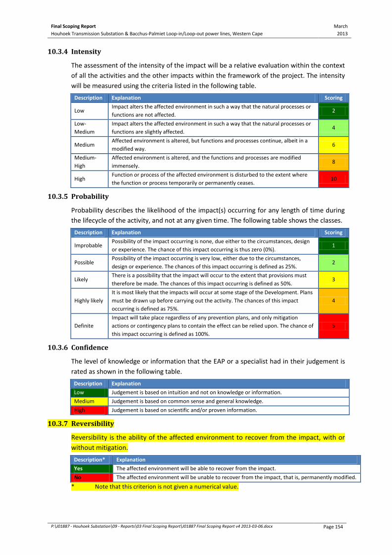
Final Scoping Report March
2013 Houhoek Transmission Substation & Bacchus-Palmiet Loop-in/Loop-out power lines, Western Cape
P:\J01887 - Houhoek Substation\09 - Reports\03 Final Scoping Report\J01887 Final Scoping Report v4 2013-03-06.docx Page 154
10.3.4 Intensity
The assessment of the intensity of the impact will be a relative evaluation within the context
of all the activities and the other impacts within the framework of the project. The intensity
will be measured using the criteria listed in the following table.
Description Explanation Scoring
Low Impact alters the affected environment in such a way that the natural processes or
functions are not affected. 2
Low-
Medium
Impact alters the affected environment in such a way that the natural processes or
functions are slightly affected. 4
Medium Affected environment is altered, but functions and processes continue, albeit in a
modified way. 6
Medium-
High
Affected environment is altered, and the functions and processes are modified
immensely. 8
High Function or process of the affected environment is disturbed to the extent where
the function or process temporarily or permanently ceases. 10
10.3.5 Probability
Probability describes the likelihood of the impact(s) occurring for any length of time during
the lifecycle of the activity, and not at any given time. The following table shows the classes.
Description Explanation Scoring
Improbable Possibility of the impact occurring is none, due either to the circumstances, design
or experience. The chance of this impact occurring is thus zero (0%). 1
Possible Possibility of the impact occurring is very low, either due to the circumstances,
design or experience. The chances of this impact occurring is defined as 25%. 2
Likely There is a possibility that the impact will occur to the extent that provisions must
therefore be made. The chances of this impact occurring is defined as 50%. 3
Highly likely
It is most likely that the impacts will occur at some stage of the Development. Plans
must be drawn up before carrying out the activity. The chances of this impact
occurring is defined as 75%.
4
Definite
Impact will take place regardless of any prevention plans, and only mitigation
actions or contingency plans to contain the effect can be relied upon. The chance of
this impact occurring is defined as 100%.
5
10.3.6 Confidence
The level of knowledge or information that the EAP or a specialist had in their judgement is
rated as shown in the following table.
Description Explanation
Low Judgement is based on intuition and not on knowledge or information.
Medium Judgement is based on common sense and general knowledge.
High Judgement is based on scientific and/or proven information.
10.3.7 Reversibility
Reversibility is the ability of the affected environment to recover from the impact, with or
without mitigation.
Description* Explanation
Yes The affected environment will be able to recover from the impact.
No The affected environment will be unable to recover from the impact, that is, permanently modified.
* Note that this criterion is not given a numerical value.

Final Scoping Report March
2013 Houhoek Transmission Substation & Bacchus-Palmiet Loop-in/Loop-out power lines, Western Cape
P:\J01887 - Houhoek Substation\09 - Reports\03 Final Scoping Report\J01887 Final Scoping Report v4 2013-03-06.docx Page 155
10.3.8 Replaceability
Replaceability is an indication of the scarcity of the specific set of parameters that make up
the affected environment. That is, if lost can the affected environment be (a) recreated, or
(b) is it a common set of characteristics and thus if lost is not considered a significant loss.
Description* Explanation
Yes Affected environment is replaceable, that is, an irreplaceable resource is not damaged, or the
resource is not irreplaceable (not scarce).
No Affected environment is irreplaceable.
* Note that this criterion is not given a numerical value.
10.3.9 Level of Significance
Based on the criteria in Chapter 10.3.2 to 10.3.6, the significance of issues was determined
using the following formula:
Significance = (Scale + Duration + Intensity) × Probability
This is the importance of the impact in terms of physical extent and time scale, and is rated
as follows:
Table 10-2: Impact Assessment Significance Rating
Significance Description Scoring
No Impact There is no impact 0 – 10
Low Impacts are less important. Some mitigation is required to reduce the negative
impacts. 11 – 30
Medium Impacts are important and require attention. Mitigation is required to reduce the
negative impacts. 31 – 60
High Impacts are of high importance. Mitigation is essential to reduce the negative
impacts. 61 – 89
Fatal Flaw Impacts present a fatal flaw, and alternatives must be considered 90 – 100
10.4 MITIGATION
Section 24(4)(b)(ii) of the EIA Regulations (2010) requires an investigation of mitigation
measures. The purpose of mitigation measures is to reduce the significance level of the
anticipated impact. Therefore, the reduction in the significance level after mitigation is
directly related to the scores used in the impact assessment criteria.
Mitigation for significant issues will be incorporated into the EMPr. The level of significance
after mitigation will indicate whether an impact can be reversed or cause irreplaceable loss
of resources.
10.5 CUMULATIVE IMPACTS
A cumulative impact, in relation to an activity, is the impact of an activity that may not be
significant but may become significant when added to the existing and potential impacts
arising from similar or other activities in the area. The possible cumulative impacts of this
project will be considered.

Final Scoping Report March
2013 Houhoek Transmission Substation & Bacchus-Palmiet Loop-in/Loop-out power lines, Western Cape
P:\J01887 - Houhoek Substation\09 - Reports\03 Final Scoping Report\J01887 Final Scoping Report v4 2013-03-06.docx Page 156
10.6 EIA REPORT
Once the specialist investigations have been completed and the findings and
recommendations have been integrated by the team, an EIA Report will be compiled
according to Government Notice R543, Section 31 (2) and will include:
A description of the EAP that prepared the report.
A detailed description of the proposed activity.
A description of the properties affected by the Houhoek Substation and the route
alignments of the respective power lines.
A description of the environment that may be affected.
A description of the PPP that was undertaken during the EIA Phase.
A description of the need and desirability of the project and details of the alternatives
that were investigated.
Findings and recommendations of the specialist studies and EAP.
An indication of the methodology used to identify significance of impacts.
A comparative assessment of all viable alternatives (including the no-go alternative).
A summary of the findings and recommendations of each specialist study report.
A description of all environmental issues that were identified, an assessment of the
significance of each issue and an indication of the extent to which the issue could be
mitigated.
An assessment of each potentially significant impact.
An opinion on whether the activity should be authorised or not and, if it should be
authorised, any conditions that should be made in respect of the authorisation.
An Environmental Impact Statement.
A draft Environmental Management Programme (EMPr) for the construction, operation
and maintenance of the proposed activity.
10.7 SITE-SPECIFIC ENVIRONMENTAL MANAGEMENT PROGRAMME
A site-specific EMPr will be included as part of the EIA Report. The recommended layout for
the Houhoek MTS and the recommended LILO corridor will require that a thorough
management plan be prepared, with a focus on the issues identified during the EIA process.
The EMPr will outline the impacts and mitigation measures for the construction phase of the
project. The EMPr will be compiled according to according to Government Notice R543,
regulation 33, and will include:
Summary of Impacts: A summary of the predicted negative environmental impacts for
which mitigation is required. Positive impacts requiring enhancement will also be listed.
Description of mitigation measures: The EMPr identifies feasible and cost-effective
mitigation measures to reduce significant negative environmental impacts to acceptable
and legal levels. Mitigation measures are described in detail and accompanied by
designs, equipment descriptions, and operating procedures, where appropriate. The
technical aspects of implementing the mitigation measures are also described.

Final Scoping Report March
2013 Houhoek Transmission Substation & Bacchus-Palmiet Loop-in/Loop-out power lines, Western Cape
P:\J01887 - Houhoek Substation\09 - Reports\03 Final Scoping Report\J01887 Final Scoping Report v4 2013-03-06.docx Page 157
Description of a monitoring programme: Environmental performance monitoring was
designed to ensure that mitigation measures are implemented. The monitoring
programme clearly indicates the links between impacts, indicators to be measured,
measurement methods and definition of thresholds that will signal the need for
corrective actions.
The Emergency Action Plan: The identification of accidents that could occur during
construction and operational phases of the project, with measures on how these could
be prevented and/or managed.
Incorporation of the Eskom’s Environmental Guidelines for bush clearing.
Institutional arrangements depict and define the responsibilities for mitigation and
monitoring actions.
Legal enforceability: The key legal considerations with respect to the EMPr are:
Legal framework for environmental protection; and
Legal basis for mitigation.
The Implementation schedule and reporting procedures that specify the timing,
frequency, and duration of the mitigation measures.
A description of requirements for record keeping, reporting, review, auditing and
updating of the EMPr will be provided.
The DEA requested the following to be included in the EMPr (as per Appendix A):
All recommendations and mitigation measure to be recorded in the Final EIA Report.
A plant rescue and protection plan, which allows for the maximum transplant of
conservation important species from areas to be transformed. This plan must be
compiled by a vegetation specialist familiar with the site in consultation with the ECO
and be implemented prior to commencement of the construction phase.
An open space management plan to be implemented during the construction and
operation of the facility.
The re-vegetation and habitat rehabilitation plan to be implemented during the
construction and operation of the facility, including timeframes for restoration, which
must indicate rehabilitation within the shortest possible time after completion of
construction activities to reduce the amount of habitat converted at any one time and to
speed up the recovery to natural habitats.
An alien invasive management plan to be implemented during construction and
operation of the facility. The plan must include mitigation measures to reduce the
invasion of alien species and ensure that the continuous monitoring and removal of alien
species is undertaken.
A storm water management plan to be implemented during the construction and
operation of the facility. The plan must ensure compliance with applicable regulations
and prevent off-site migration of contaminated storm water or increased soil erosion.
The plan must include construction of appropriate design measure that allow surface
and subsurface movement of water along drainage lines so as not to impede natural
surface and subsurface flows. Drainage measures must promote the dissipation of storm
water run-off.

Final Scoping Report March
2013 Houhoek Transmission Substation & Bacchus-Palmiet Loop-in/Loop-out power lines, Western Cape
P:\J01887 - Houhoek Substation\09 - Reports\03 Final Scoping Report\J01887 Final Scoping Report v4 2013-03-06.docx Page 158
An effective monitoring system to detect any leakage or spillage of all hazardous
substances during their transportation, handling, use and storage. This must include
precautionary measures to limit the possibility of oil and other toxic liquids from
entering the soil or storm water systems.
An erosion management plan for monitoring and rehabilitating erosion events
associated with the facility. Appropriate erosion mitigation must form part of this plan to
prevent and reduce the risk of any potential erosion.
A traffic management plan for the site access roads to ensure that no hazards would
result from the increased truck traffic and that traffic flow would not be adversely
impacted. This plan must include measures to minimise impacts on local commuters e.g.
limiting construction vehicles travelling on public roadways during the morning and later
afternoon commute time and avoid using roads through densely populated built-up
areas so as not to disturb existing retail and commercial operations.
An environmental sensitivity map indicating environmental sensitive areas and features
identified during the EIA process.
Measures to protect hydrological features such as streams, rivers, pans, wetlands, dams
and their catchments, and other environmental sensitive areas from construction
impacts, including the direct and indirect spillage of pollutants.
10.8 PUBLIC PARTICIPATION PROCESS (EIA PHASE)
The objective of the PPP in the EIA phase of the project is to present the findings of the
investigations to the stakeholders and to give them an opportunity to comment on these.
To achieve this, the following consultation process will be undertaken, similar to the Scoping
Phase:
The draft EIA Report will be available for review by registered I&APs for a period of 40
days (determined under the guidance of the DEA).
Public meetings will be held at various locations in the study area to present the findings
of the EIA Report to I&APs.
Correspondence with I&APs will include the Xhosa language in addition to English and
Afrikaans, as requested by I&APs.
All of the registered I&APs on the I&AP database will be notified in writing
(via e-mail/post/fax) of the abovementioned consultation process. Advertisements will also
be placed in the local newspapers, site notices will be placed around the study area and
flyers will be handed out to the local community.
Comments and issues raised will be noted in an updated version of the Issues and Responses
Report (Appendix C). These comments will be considered and incorporated into the Final EIA
Report for submission to the DEA.
All registered I&APs (including the appellant) will be informed by e-mail, facsimile or post of
the outcome of the DEA’s decision. In addition, the registered I&APs will be informed of the
procedure to lodge a further appeal, if they still wish to do so.

Final Scoping Report March
2013 Houhoek Transmission Substation & Bacchus-Palmiet Loop-in/Loop-out power lines, Western Cape
P:\J01887 - Houhoek Substation\09 - Reports\03 Final Scoping Report\J01887 Final Scoping Report v4 2013-03-06.docx Page 159
10.9 ENVIRO-LEGAL REVIEW
The enviro-legal review will largely involve review responsibilities and advice on process
issues. BKS will ensure that the EIA process followed is fully compliant with the legal
requirements.
The following specific input will be provided by the enviro-legal team (see Chapter 2.8):
Reviews of the Draft Scoping Report and Plan of Study for EIA as well as of the Draft EIA
Report and Draft EMPr with brief written comments on the legal process followed.
Ad hoc telephonic/e-mail input to project team queries, including legal issues emerging
from the public participation process.
A review of the enviro-legal requirements that apply to the Houhoek Transmission
Substation project.
10.10 PEER REVIEW OF DRAFT EIA REPORT
A peer review will be undertaken in order to ensure that the reports as generated from the
EIA process are deemed to be:
Unbiased.
Comprehensive.
Appropriate and compliant to the legislative framework (i.e. meeting the letter and spirit
of the law).
Meet the procedural requirements of the legislation.
Are in line with best practice in South Africa.
The Draft EIA Reports will be reviewed in detail by an acknowledged environmental
assessment specialist. Edits will be made according to this input, the documents then
finalised, and the documentation finally submitted to the DEA for consideration.
10.11 PROJECT PROCESS PROGRAMME
The key dates for the EIA process of the Houhoek Transmission Substation project are
presented in Table 10-3 to follow.
Table 10-3: Key Dates in the EIA Phase
Activity Date
Public Review of comprehensive Draft EIA Report 16 July 2013 – 16 September 2013
Anticipated dates of public meetings 30 – 31 July 2013
Submission of Final EIA Report to the DEA 11 October 2013
Authority Acceptance/Rejection of EIA Report 21 October 2013 – 12 November 2013
Environmental Authorisation Issued 13 November 2013
Appeal Notification Process 13 November 2013 – 25 November 2013
Servitude Negotiation Process (appeals
dependent) 2 December 2013

Final Scoping Report March
2013 Houhoek Transmission Substation & Bacchus-Palmiet Loop-in/Loop-out power lines, Western Cape
P:\J01887 - Houhoek Substation\09 - Reports\03 Final Scoping Report\J01887 Final Scoping Report v4 2013-03-06.docx Page 160
11 CONCLUSION AND RECOMMENDATIONS
The key issues identified during the Scoping Phase for the construction and operational
phases of the project are:
Construction-related Impacts
Geotechnical Impacts
Soil & Agricultural Impacts
Impacts on Freshwater Ecosystems
Ecological Impacts
Avifauna Impacts
o Electrocutions
o Collisions
o Displacement due to Habitat Destruction
o Displacement due to Disturbance
Socio-Economic Impacts
Visual Impacts
Heritage Impacts
Traffic Impacts
The EAP believes that Eskom Holdings SOC Limited has followed due environmental process
during the undertaking of this scoping process and associated PPP. The identification of key
issues during the scoping process has not shown any negative impacts that may be
considered as fatal flaws. However, a number of potentially significant issues have been
highlighted for further investigation to assess their significance, and to determine the need
for the implementation of mitigation measures in order for the overall project to be
environmentally sustainable.
The study area has also been revised as per Figure 10-1, which will be considered in further
detail in the EIA Phase. Site Alternative 2 and Site Alternative 3 have been dismissed during
the scoping phase, and 2 distinct corridors have been identified for the 400kV LILO
Transmission power lines. A new layout alternative for Site Alternative 1 has also been
proposed for further investigation in the EIA Phase.
Following the review period of the Draft SR, the issues raised by I&APs and regulatory
authorities were highlighted in yellow and presented in this Final Scoping Report, which was
submitted to the competent approving authority, the DEA, for consideration and
acceptance. Following which, the EIA Phase will commence.
It is, therefore, recommended that the DEA accept the Scoping Report and issue permission
to undertake the EIA Phase of the EIA process as outlined in the Plan of Study for EIA
(Chapter 10).

Final Scoping Report March
2013 Houhoek Transmission Substation & Bacchus-Palmiet Loop-in/Loop-out power lines, Western Cape
P:\J01887 - Houhoek Substation\09 - Reports\03 Final Scoping Report\J01887 Final Scoping Report v4 2013-03-06.docx Page 161
12 REFERENCES
Almond, J., 2012. Palaeontological specialist report for the proposed Langhoogte Wind Energy
Facility, s.l.: Natura Viva cc for Arcus Gibb (Pty) Ltd.
Animal Demography Unit, 2013. The Virtual Museum @ ADU. [Online] Available at:
http://vmus.adu.org.za [Accessed February 2013].
Arcus Gibb, 2012. Langhoogte Wind Farm Draft EIA, Johannesburg: Arcus Gibb (Pty) Ltd.
Barnes, K. N., 1998. The Important Bird Areas of Southern Africa. Johannesburg: BirdLife South
Africa.
Barnes, K. N., 2000. The Eskom Red Data Book of Birds of South Africa, Lesotho and Swaziland.
Johannesburg: BirdLife South Africa.
Bates, M. F. et al., in press. Atlas and Red List of the Reptiles of South Africa, Lesotho and Swaziland,
Pretoria: South African National Biodiversity Institute.
Burdge, R. J., 1995. A community guide to Social Impact Assessment. s.l.:s.n.
DEA, 2011. Threatened Terrestrial Ecosystems in South Africa. Volume 1002: No. 34809 National
Printer ed. Pretoria: Government Gazette.
Driver, A. et al., 2011. Implementation Manual for Freshwater Ecosystem Priority Areas. WRC Report
No. 1801/1/11 ed. Pretoria: Water Research Commission.
Du Toit, S. J., 2004. Spore oor die Overberg: Geskiedkundige anecdotes uit die Overberg. Cape Town:
ABC Drukkers.
EWT, 2004. Little Red Data Book of the Mammals of South Africa: A Conservation Assessment.
Johannesburg: Endangered Wildlife Trust.
Harrison, J. A. et al., 1997. The atlas of Southern African birds. Vol 1 & 2 ed. s.l.:BirdLife South Africa.
Hart, T., 2010. Heritage Impact Assessment: Proposed Wind Energy Facility near Caledon, s.l.:
Unpublished Report for Savannah Environmental (Pty) Ltd.
Helme, N., 2004. Botanical Assessment of Proposed Changes to Eskom Line Between Houhoek and
Hermanus Substations, Scarborough: Unpublished Report for Eskom Distribution, Brackenfell.
Hockey, P. A. R., Dean, W. R. J. & Ryan, P. G., 2005. Robert's Birds of Southen Africa. Seventh Edition
ed. Cape Town: Trustees of the John Voelcker Bird Book Fund.
Holness, S. & Bradshaw, P., 2010. Critical Biodiversity Areas of the Overberg District Municipality.
[Online] Available at: http://sites.google.com/site/overbergcba/Home/ [Accessed 2012].
Kaplan, J., 2006. Phase 1 Archaeological Impact Assessment: Proposed Development of Portion 5 of
Farm 436 Caledon, s.l.: Unpublished Report by Agency for Cultural Resources Management.
Kaplan, J., 2006. Phase 1 Archaeological Impact Assessment: Proposed Housing Development on
Portion 25 of the Farm Compagniesdrift 436 Caledon, s.l.: Unpublished Report by Agency for Cultural
Resource Management.

Final Scoping Report March
2013 Houhoek Transmission Substation & Bacchus-Palmiet Loop-in/Loop-out power lines, Western Cape
P:\J01887 - Houhoek Substation\09 - Reports\03 Final Scoping Report\J01887 Final Scoping Report v4 2013-03-06.docx Page 162
Kaplan, J., 2007. Phase 1 Archaeological Impact Assessment: Proposed Overberg Gateway
Development (Phase 1 and 2), s.l.: Unpublished Report by Agency for Cultural Resource
Management.
Kleynhans, C. J., Thirion, C. & Moolman, J., 2005. A Level 1 River Ecoregion Classification System for
South Africa, Lesotho and Swaziland. Report No. N/0000/00/REQ0104 ed. Pretoria: Resources
Quality Service (DWAF).
Measy, G. J. (., 2011. Ensuring a future for South Africa's Frogs: A strategy for conservation research,
Pretoria: SANBI Biodiversity Series 19.
Minter, L. et al., 2004. Atlas and Red Data Book of the Frogs of South Africa, Lesotho and Swaziland.
SI/MAB Series #9 ed. Washington D C: Simithsonian Institution.
Monadjem, A., Taylor, P. J., Cotterill, F. P. D. & Corrie-Schoeman, M., 2010. Bats of Southern and
Central Africa - A Biogeographic and Taxonomic Thesis, Johannesburg: Wits University Press.
Mucina, L. & Rutherford, M. C., 2006. The vegetation of South Africa, Lesotho and Swaziland.
Strelitzia 19 ed. Pretoria: South African National Biodiversity Institute.
Net-Focus Interactive, 2012. SA-Venues.com. [Online] Available at: http://www.sa-
venues.com/attractionswc/botrivier.php
Oberholzer, B., 2005. Guideline for involving visual and aestehtic specialists in EIA processes. CSIR
Report No ENV-S-C 2005 053 F. Edition 1 ed. Cape Town: Western Cape Department of
Environmental Affairs & Development Planning.
Overberg Online, 2012. [Online] Available at: http://www.overbergonline.co.za/botrivier.php
Overberg Website, 2006. Overberg.co.za. [Online] Available at: http://www.overberg.co.za/
[Accessed February 2013].
Overstrand Heritage Landscape Group, 2009. Overstrand Heritage Survey, s.l.: Unpublished Report
for the Overstrand Municipality.
Raimondo, D. et al., 2009. Red List of South African Plants. eds. 2009 ed. Pretoria: Strelitzia 25. South
African National Biodiversity Institute.
Rouget, M. et al., 2004. South African National Spatial Biodiversity Assessment 2004: Technical
Report. Volume 1: Terrestrial Component ed. Pretoria: South African National Biodiversity Institute.
SANBI, 2009. Further Development of a Proposed National Wetland Classification System for South
Africa. Final Primary Project Report ed. s.l.:Freshwater Consulting Group for SANBI.
SANS-10160-4;, 2011. Part 4: Seismic Actions and General Requirements, s.l.: ISBN 978-0-626-26431-
4.
Schoefield, N. C., 2007. Commodity Derivatives: Market Applications. West Sussex: John Wiley &
Sons Ltd.
Spoon Press, 2002. Guidelines for Landscape and Visual Impact Assessment. U.K. Institute of
Environmental Management and Assessment, Issue Second Edition, p. 44.
StatsSA, 2007. Community Survey 2007, s.l.: Basic Results Municipalities.

Final Scoping Report March
2013 Houhoek Transmission Substation & Bacchus-Palmiet Loop-in/Loop-out power lines, Western Cape
P:\J01887 - Houhoek Substation\09 - Reports\03 Final Scoping Report\J01887 Final Scoping Report v4 2013-03-06.docx Page 163
Theewaterskloof Local Municipality, 2011. Integrated Development Plan 2011-2016: 3rd Generation
IDP, s.l.: s.n.
Theewaterskloof Local Municipality, 2012. Spatial Development Framework Volume II, s.l.: s.n.
Vosloo, H. F., 2009. Transmission Vegetation Management Guidline, s.l.: Eskom Transmission.
Webley, L. & Halkett, D., 2011. Heritage Impact Assessment for the Caledon Wind Farm, Western
Cape Province, s.l.: Unpublished Report for Arcus Gibb (Pty) Ltd.
Young, D. J. et al., 2003. Big Birds on Farms. Mazda CAR Report (1993-2001), Cape Town: Avian
Demography Unit. University of Cape Town.
Legislation
Conservation of Agricultural Resources Act (Act No. 43 of 1983)
Convention on Biological Diversity. Signed 1993 and ratified 2 November 1995
National Environmental Management Act (No. 107 of 1998)
National Environmental Management Biodiversity Act (No. 10 of 2004)
National Forests Act (No. 84 of 1998)
South African Heritage Resources Act (No. 25 of 1999)

Final Scoping Report March
2013 Houhoek Transmission Substation & Bacchus-Palmiet Loop-in/Loop-out power lines, Western Cape
P:\J01887 - Houhoek Substation\09 - Reports\03 Final Scoping Report\J01887 Final Scoping Report v4 2013-03-06.docx Page 164
GLOSSARY OF TECHNICAL TERMS
Kilovolt: A unit of potential differences equal to 1000 volts.
No-go area: An area in which the Houhoek Transmission Substation, Transmission or
Distribution power line cannot be routed due to resulting significant
environmental, social and technical impacts.
Pylon: A large vertical steel tower-like structure supporting high-voltage electrical
cables.
Route: The exact servitude in which the Transmission power line could be built.
Route
Alignment:
The alignment of the servitude within which the Transmission or Distribution
power line could be built.
Route Corridor: A passage on either side of a corridor – in this case amounts to 500m on either
side of the route alignment of the Transmission or Distribution power lines.
Servitude Right: A real right in favour of the servitude holder allowing the erection and
maintenance of structures and cables to transmit electricity over portions of land
and restricting any activities that could pose a hazard to the transmission of
electricity, the environment and/or the safety of human and other living beings.
Study area: The area that will be covered by the Environmental Authorisation process within
which possible route alignment alternatives for the Transmission or Distribution
power lines, and location and layout alternatives for the Houhoek Transmission
Substation will be investigated.
Substation: A collection of equipment for the purpose of raising, lowering and regulating the
voltage of electricity.