5.1 SOILS AND GEOLOGY - Alaska Stand Alone...
28
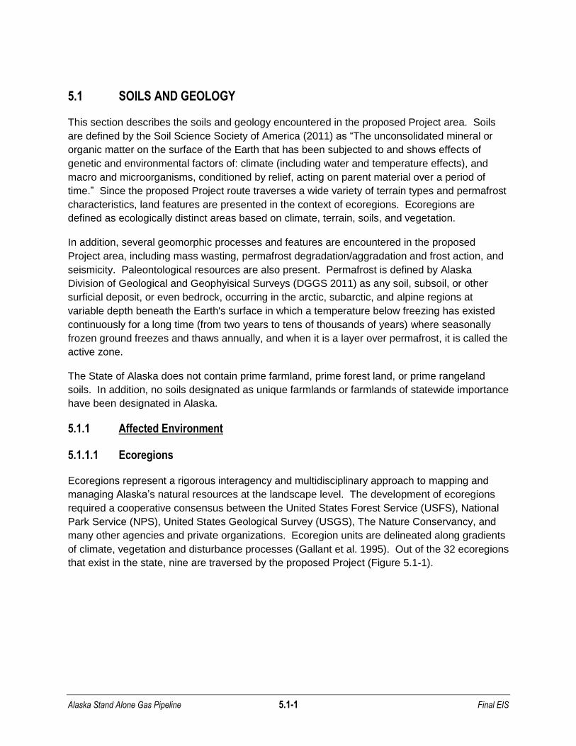
Alaska Stand Alone Gas Pipeline 5.1-1 Final EIS 5.1 SOILS AND GEOLOGY This section describes the soils and geology encountered in the proposed Project area. Soils are defined by the Soil Science Society of America (2011) as “The unconsolidated mineral or organic matter on the surface of the Earth that has been subjected to and shows effects of genetic and environmental factors of: climate (including water and temperature effects), and macro and microorganisms, conditioned by relief, acting on parent material over a period of time.” Since the proposed Project route traverses a wide variety of terrain types and permafrost characteristics, land features are presented in the context of ecoregions. Ecoregions are defined as ecologically distinct areas based on climate, terrain, soils, and vegetation. In addition, several geomorphic processes and features are encountered in the proposed Project area, including mass wasting, permafrost degradation/aggradation and frost action, and seismicity. Paleontological resources are also present. Permafrost is defined by Alaska Division of Geological and Geophyisical Surveys (DGGS 2011) as any soil, subsoil, or other surficial deposit, or even bedrock, occurring in the arctic, subarctic, and alpine regions at variable depth beneath the Earth's surface in which a temperature below freezing has existed continuously for a long time (from two years to tens of thousands of years) where seasonally frozen ground freezes and thaws annually, and when it is a layer over permafrost, it is called the active zone. The State of Alaska does not contain prime farmland, prime forest land, or prime rangeland soils. In addition, no soils designated as unique farmlands or farmlands of statewide importance have been designated in Alaska. 5.1.1 Affected Environment 5.1.1.1 Ecoregions Ecoregions represent a rigorous interagency and multidisciplinary approach to mapping and managing Alaska’s natural resources at the landscape level. The development of ecoregions required a cooperative consensus between the United States Forest Service (USFS), National Park Service (NPS), United States Geological Survey (USGS), The Nature Conservancy, and many other agencies and private organizations. Ecoregion units are delineated along gradients of climate, vegetation and disturbance processes (Gallant et al. 1995). Out of the 32 ecoregions that exist in the state, nine are traversed by the proposed Project (Figure 5.1-1).
Transcript of 5.1 SOILS AND GEOLOGY - Alaska Stand Alone...
Alaska Stand Alone Gas Pipeline 5.1-1 Final EIS
5.1 SOILS AND GEOLOGY
This section describes the soils and geology encountered in the proposed Project area. Soils
are defined by the Soil Science Society of America (2011) as “The unconsolidated mineral or
organic matter on the surface of the Earth that has been subjected to and shows effects of
genetic and environmental factors of: climate (including water and temperature effects), and
macro and microorganisms, conditioned by relief, acting on parent material over a period of
time.” Since the proposed Project route traverses a wide variety of terrain types and permafrost
characteristics, land features are presented in the context of ecoregions. Ecoregions are
defined as ecologically distinct areas based on climate, terrain, soils, and vegetation.
In addition, several geomorphic processes and features are encountered in the proposed
Project area, including mass wasting, permafrost degradation/aggradation and frost action, and
seismicity. Paleontological resources are also present. Permafrost is defined by Alaska
Division of Geological and Geophyisical Surveys (DGGS 2011) as any soil, subsoil, or other
surficial deposit, or even bedrock, occurring in the arctic, subarctic, and alpine regions at
variable depth beneath the Earth's surface in which a temperature below freezing has existed
continuously for a long time (from two years to tens of thousands of years) where seasonally
frozen ground freezes and thaws annually, and when it is a layer over permafrost, it is called the
active zone.
The State of Alaska does not contain prime farmland, prime forest land, or prime rangeland
soils. In addition, no soils designated as unique farmlands or farmlands of statewide importance
have been designated in Alaska.
5.1.1 Affected Environment
5.1.1.1 Ecoregions
Ecoregions represent a rigorous interagency and multidisciplinary approach to mapping and
managing Alaska’s natural resources at the landscape level. The development of ecoregions
required a cooperative consensus between the United States Forest Service (USFS), National
Park Service (NPS), United States Geological Survey (USGS), The Nature Conservancy, and
many other agencies and private organizations. Ecoregion units are delineated along gradients
of climate, vegetation and disturbance processes (Gallant et al. 1995). Out of the 32 ecoregions
that exist in the state, nine are traversed by the proposed Project (Figure 5.1-1).

Alaska Stand Alone Gas Pipeline 5.1-2 Final EIS
FIGURE 5.1-1 Alaska Stand Alone Gas Pipeline Ecoregions
Alaska Stand Alone Gas Pipeline 5.1-3 Final EIS
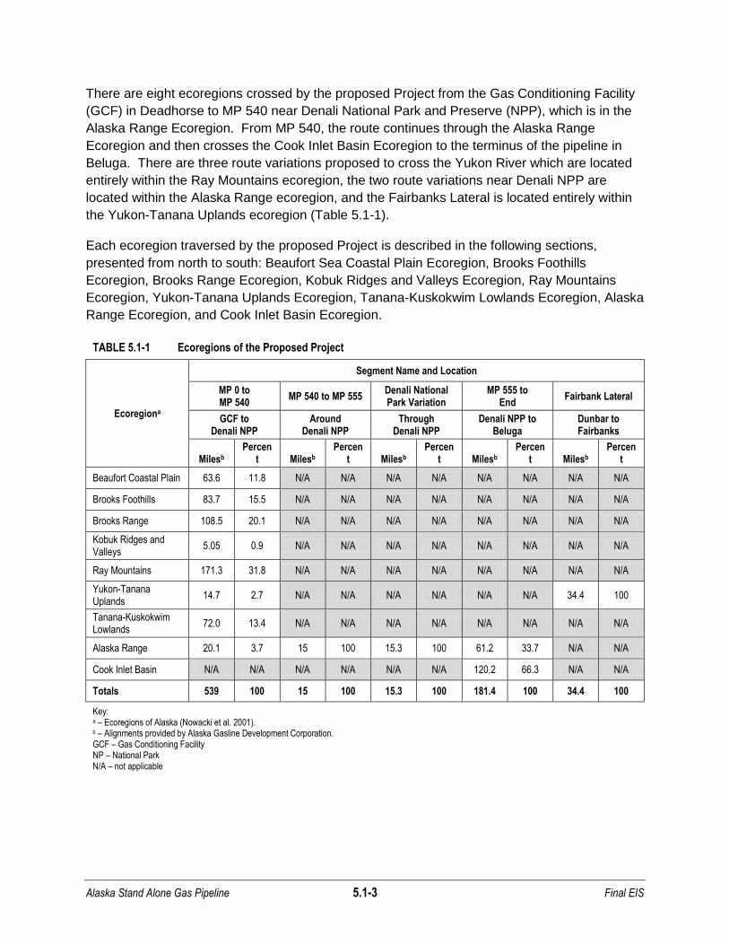
There are eight ecoregions crossed by the proposed Project from the Gas Conditioning Facility
(GCF) in Deadhorse to MP 540 near Denali National Park and Preserve (NPP), which is in the
Alaska Range Ecoregion. From MP 540, the route continues through the Alaska Range
Ecoregion and then crosses the Cook Inlet Basin Ecoregion to the terminus of the pipeline in
Beluga. There are three route variations proposed to cross the Yukon River which are located
entirely within the Ray Mountains ecoregion, the two route variations near Denali NPP are
located within the Alaska Range ecoregion, and the Fairbanks Lateral is located entirely within
the Yukon-Tanana Uplands ecoregion (Table 5.1-1).
Each ecoregion traversed by the proposed Project is described in the following sections,
presented from north to south: Beaufort Sea Coastal Plain Ecoregion, Brooks Foothills
Ecoregion, Brooks Range Ecoregion, Kobuk Ridges and Valleys Ecoregion, Ray Mountains
Ecoregion, Yukon-Tanana Uplands Ecoregion, Tanana-Kuskokwim Lowlands Ecoregion, Alaska
Range Ecoregion, and Cook Inlet Basin Ecoregion.
TABLE 5.1-1 Ecoregions of the Proposed Project
Ecoregiona
Segment Name and Location
MP 0 to MP 540
MP 540 to MP 555 Denali National Park Variation
MP 555 to End
Fairbank Lateral
GCF to Denali NPP
Around Denali NPP
Through Denali NPP
Denali NPP to Beluga
Dunbar to Fairbanks
Milesb Percen
t Milesb Percen
t Milesb Percen
t Milesb Percen
t Milesb Percen
t
Beaufort Coastal Plain 63.6 11.8 N/A N/A N/A N/A N/A N/A N/A N/A
Brooks Foothills 83.7 15.5 N/A N/A N/A N/A N/A N/A N/A N/A
Brooks Range 108.5 20.1 N/A N/A N/A N/A N/A N/A N/A N/A
Kobuk Ridges and Valleys
5.05 0.9 N/A N/A N/A N/A N/A N/A N/A N/A
Ray Mountains 171.3 31.8 N/A N/A N/A N/A N/A N/A N/A N/A
Yukon-Tanana Uplands
14.7 2.7 N/A N/A N/A N/A N/A N/A 34.4 100
Tanana-Kuskokwim Lowlands
72.0 13.4 N/A N/A N/A N/A N/A N/A N/A N/A
Alaska Range 20.1 3.7 15 100 15.3 100 61.2 33.7 N/A N/A
Cook Inlet Basin N/A N/A N/A N/A N/A N/A 120.2 66.3 N/A N/A
Totals 539 100 15 100 15.3 100 181.4 100 34.4 100
Key: a – Ecoregions of Alaska (Nowacki et al. 2001). b – Alignments provided by Alaska Gasline Development Corporation. GCF – Gas Conditioning Facility NP – National Park N/A – not applicable

Alaska Stand Alone Gas Pipeline 5.1-4 Final EIS
Beaufort Coastal Plain Ecoregion
The Beaufort Coastal Plain Ecoregion features smooth, planar topography, rising gradually for
60 miles north to south to an elevation of approximately 600 feet (Wahrhaftig 1965). The
Beaufort Sea Coastal Plain Ecoregion is characterized by a network of polygonal ground
features, forming shallow troughs at the borders, and oriented thaw lakes formed by permafrost
processes. Locally, pingos (mounds of earth-covered ice) form in flat, low-lying, drained or
sediment-filled ponds (BLM and ANHA 1993, French 2007). The polygonal ground features are
generally comprised of marine, fluvial, eolian, and lacustrine sediments of Quaternary age
(Kreig and Reger 1982). The coastal plain is mantled with Quaternary deposits of alluvial,
glacial, and aeolian origin. Siltstone and sandstone lie beneath the unconsolidated materials at
varying depths ranging from 10 to more than 30 feet (Gallant 1995). The proposed Project
would not cross any known active faults within this ecoregion.
Throughout most of the proposed Project area in this ecoregion, the floodplain of the
Sagavanirktok River grades from a braided river system to a meandering channel flowing north
toward the Beaufort Sea. The braided nature of the river channels reflects the unconsolidated
nature of the bedrock, the availability of abundant bedload, and the highly seasonal discharge
regime. During summer, the gradual melt of snowbanks on east-facing slopes provides
moisture for mass wasting (solifluction) to occur (French 2007), although the solifluction process
can be active on slopes of any aspect. Locally, channels may be floored with sandy silts that
represent former, seasonal floodplain deposits overlying sand and gravel (Kreig and
Reger 1982). Sheet ice from successive stream bank overflows is present on various sections
of the floodplain during winter (APSC 2007) and can persist into the summer in many areas.
The dominant soils of the Beaufort Coastal Plain consist of several feet of ice-rich organic silt
overlaying coarse sands and gravels (APSC 2007). Massive ground ice is widespread
throughout the area, appearing as vertical wedges, films, lenses, pore-fillings, and segregated
masses. Networks of ice wedges create polygonal ground features on the surface.
The Beaufort Coastal Plain Ecoregion is underlain by thick, continuous permafrost, with an
average temperature of less than 19°F (Brown et al. 1997, Ferrians 1965). The permafrost is
670- to 2,150-feet thick in most areas (Péwé 1975). Polygonal ground features, formed by
ground contraction and ice wedge formation and oriented lakes, formed by the thawing of ice-
rich soils, characterize low-lying areas. Shallow thaw bulbs may be present beneath active river
channels and lakes at depths greater than 6 feet (Kreig and Reger 1982).
Brooks Foothills Ecoregion
The Brooks Foothills Ecoregion features glacial moraines composed primarily of coarse-grained
till covered with loess, extensive glacial outwash deposits and low-elevation bedrock landforms,
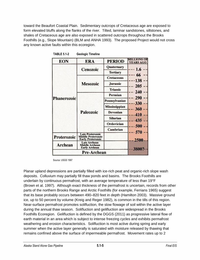
generally rising to a few hundred feet in elevation and comprised primarily of sandstone,
siltstone, and shale of Cretaceous age (Table 5.1-2) (BLM and ANHA 1993). The proposed
Project area in this ecoregion is drained primarily by the north-flowing Sagavanirktok River,
which is characterized by a braided river system grading to a meandering channel flowing north
Alaska Stand Alone Gas Pipeline 5.1-5 Final EIS
toward the Beaufort Coastal Plain. Sedimentary outcrops of Cretaceous age are exposed to
form elevated bluffs along the flanks of the river. Tilted, laminar sandstones, siltstones, and
shales of Cretaceous age are also exposed in scattered outcrops throughout the Brooks
Foothills (e.g., Slope Mountain) (BLM and ANHA 1993). The proposed Project would not cross
any known active faults within this ecoregion.
TABLE 5.1-2 Geologic Timeline
Source: USGS 1997
Planar upland depressions are partially filled with ice-rich peat and organic-rich slope wash
deposits. Colluvium may partially fill thaw ponds and basins. The Brooks Foothills are
underlain by continuous permafrost, with an average temperature of less than 19°F
(Brown et al. 1997). Although exact thickness of the permafrost is uncertain, records from other
parts of the northern Brooks Range and Arctic Foothills (for example, Ferrians 1965) suggest
that its base probably occurs between 490–820 feet in depth (Hamilton 2003). Massive ground
ice, up to 50 percent by volume (Kreig and Reger 1982), is common in the tills of this region.
Near-surface permafrost promotes solifluction, the slow flowage of soil within the active layer
during the annual thaw season. Solifluction and gelifluction are widespread in the Brooks
Foothills Ecoregion. Gelifluction is defined by the DGGS (2011) as progressive lateral flow of
earth material in an area which is subject to intense freezing cycles and exhibits permafrost
weathering and erosion characteristics. Solifluction is most active during spring and early
summer when the active layer generally is saturated with moisture released by thawing that
remains confined above the surface of impermeable permafrost. Movement rates up to 2

Alaska Stand Alone Gas Pipeline 5.1-6 Final EIS
inches per year are common, but more rapid rates up to 4 or even 6 inches per year have been
recorded on some solifluction slopes (Hamilton 2003). Permafrost free zones or thaw bulbs
(taliks) are likely to occur only beneath water bodies with depths greater than 6 feet
(French 2007). In the floodplain of the Sagavanirktok River continuous permafrost is present
adjacent to the active channel.
River and stream icings, a phenomenon also called aufeis, may occur during freeze-up and in
winter. Stream icings are attributed either to a reduction in the cross-sectional area of an ice
covered channel as freezing advances, or to an increase in snow load on an initial ice cover
thus raising the hydrostatic head beneath the ice to an elevation higher than the ice surface. If
water cannot escape from the banks due to the freezing of the active layer, fractures in the ice
can allow water to escape over the ice cover, freezing as an icing. In shallow braided streams,
small icing mounds, 3- to 10-feet high, may develop in response to localized restrictions of flow
by ice freezing to the bed of the braid bars (French 2007).
Brooks Range Ecoregion
The Brooks Range Ecoregion is comprised of rugged, glaciated, east-west trending mountains
rising from the Brooks Foothills to elevations ranging from 4,000 to 8,000 feet
(Wahrhaftig 1965). Erosional landforms associated with alpine glaciers, such as cirques and U-
shaped valleys, are common throughout the Brooks Range. Talus slopes, alluvial fans,
moraines, and outwash fans are well developed at the bases of valleys and cirques. Drainages
in the north Brooks Range discharge through the Sagavanirktok River to the Arctic Ocean;
drainages in the south discharge to the Bering Sea via the Atigun and Dietrich Rivers. Most of
the major drainages flow to discharge locations within U-shaped valleys, scoured by Pleistocene
glaciations (APSC 2007).
Bedrock in the Brooks Range includes folded and thrusted Paleozoic and Mesozoic
sedimentary rocks (exposed in the northern flank of the range), deformed Paleozoic
metamorphic rocks (in the central Brooks Range), and Late Proterozoic to Paleozoic
metamorphic rocks (in the southern Brooks Range) (Moore et al. 1994). Surficial deposits of the
Brooks Range are modern stream alluvium and Pleistocene age and younger fluvial, lacustrine,
colluvial, glacial, and glaciofluvial sediments (Hamilton 2003). The proposed Project would not
cross any known active faults within this ecoregion.
Coarse-grained sands and gravels underlie the Atigun River and Dietrich River valleys within
the proposed Project area of the Brooks Range. Windblown silts and sands are present in the
Atigun River floodplain (Kreig and Reger 1982). Near the toes of steep-sloped alluvial fans,
moraines, talus, and unsorted, coarse to very-coarse sediments are common. In previously
scoured glacial basins (e.g., Galbraith Lake), lacustrine silt and clay may overlie coarse-grained
glaciofluvial and glacial deposits.
The Brooks Range is underlain predominantly by continuous permafrost that has an average
temperature of 19°F to 27°F (Brown et al. 1997). Ground ice contents vary from up to 15
percent ice in fluvial silts and sands, to 25 to 95 percent ice in lacustrine silts and clays near

Alaska Stand Alone Gas Pipeline 5.1-7 Final EIS
Galbraith Lake. In river valleys, vegetated areas of moraine, fan, and alluvial deposits are
continuously frozen from the base of the active layer to more than 50 feet below ground surface
in the northern Brooks Range (Kreig and Reger 1982). Permafrost depth is greater in coarse
grained deposits than in fine grained deposits and trends from north (deeper) to south
(shallower). Due to seasonal variations and the heat from water within river channels,
permafrost can be discontinuous within the alluvium underlying major active rivers
(Ferrians 1965, Kreig and Reger 1982).
Kobuk Ridges and Valleys Ecoregion
The Kobuk Ridges and Valleys Ecoregion consists of low ridges and lowlands south of the
Brooks Range (Wahrhaftig 1965). The proposed Project area follows the floodplain of the
Middle Fork Koyukuk River These lowlands are underlain by unconsolidated Quaternary
sediments. Late Paleozoic and Mesozoic igneous rocks (both extrusive and intrusive) are
exposed at the surface of ridges (BLM and ANHA 1993). Very little is known about the seismic
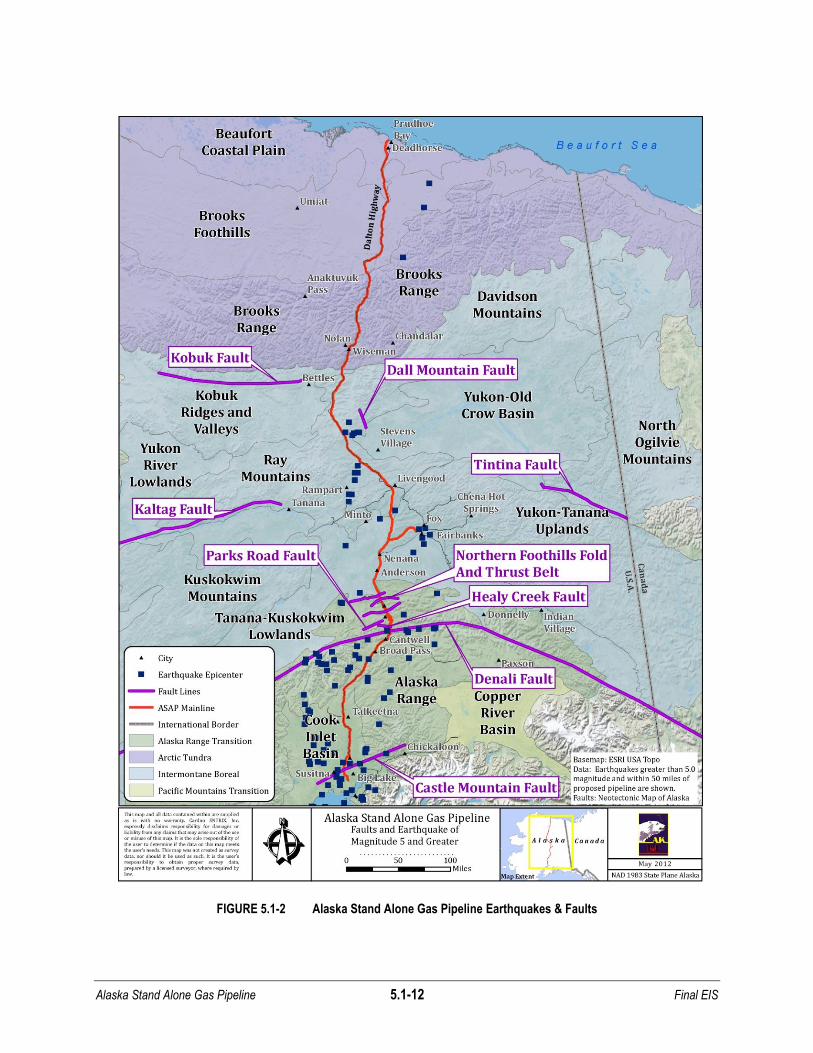
potential of the Kobuk fault, a Cenozoic strike-slip fault approximately 40 miles away from the
proposed Project area, on the southern flank of the Brooks Range (Freymueller et al. 2008).
The proposed Project would not cross any known active faults within this ecoregion
(Figure 5.1-2). The soils of Kobuk Ridges and Valleys are a product of Pleistocene glaciations.
Coarse-grained glacial and glaciofluvial sediments are distributed near the main channels of the
Middle and South Fork Koyukuk rivers. Away from the channels, soils consist of fine-grained silt
and clay of eolian and lacustrine origins that overlie coarse-grained glacial tills (Hamilton 1994).
Thaw lakes are well developed in the silt of the lowlands between the Middle and South Fork
Koyukuk rivers.
This ecoregion is underlain by discontinuous permafrost with an average temperature of 27F to
30F (Brown et al. 1997). The proposed Project area runs through only five miles of the Kobuk
Ridges and Valleys Ecoregion and is most likely within a continuous permafrost zone.
Permafrost is generally absent beneath unvegetated floodplains within the region. Vegetated
floodplains can overlie permafrost between 5- and 50-feet thick in local areas (Kreig and
Reger 1982).
Ray Mountains Ecoregion
The Ray Mountains Ecoregion consists of rounded hills rising from 2,000 to 4,000 feet and
extending to the Hess River, marking the location of the Rampart Trough (described below)
(Wahrhaftig 1965). The Ray Mountains supported glaciers in the Pleistocene but are now
largely unglaciated and commonly covered with colluvial and eolian deposits. Lower elevations
are covered with retransported eolian deposits. The northern portions of the Ray Mountains are
composed primarily of Proterozoic through Paleozoic age metamorphic rock, with some igneous
intrusions of Cretaceous age present (BLM and ANHA 1993). The southern portion of the Ray
Mountains consists predominantly of fine-grained, massive volcanics, and thinly interbedded
cherts of Late Paleozoic to Middle Mesozoic ages. Bedrock in the uplands is primarily
metamorphic rock of Paleozoic age (Foster et al. 1994). The proposed Project would not cross
any known active faults in this ecoregion (Figure 5.1-2). The Kaltag and Tintina Faults project
Alaska Stand Alone Gas Pipeline 5.1-8 Final EIS
through the region; however, the location and kinematic connection between these faults is
poorly defined. Both faults are thought to be active and even though the proposed alignment
does not cross these structures, they could generate strong ground motion.
The Rampart Trough, near the Hess River, is a narrow depression created by erosional
processes along a tightly-folded belt of soft, coal-bearing rocks of Tertiary age.
Topographically, the Rampart Trough is 500 to 2,500 feet below the surrounding upland terrain
(Wahrhaftig 1965) and has been seismically active. The Rampart seismic zone is situated
between the Kaltag fault and Tintina fault system, northwest of Fairbanks. This area was the
location of a magnitude 5.0 earthquake in 2003 about 15 miles south-south east of the Village of
Rampart and was felt strongly by residents throughout the area. The largest recorded
earthquake in the Rampart seismic zone was a magnitude 6.8 that occurred in 1968. Northeast
of the Rampart seismic zone is a cluster of earthquake activity known as the Dall City seismic
zone. Little is known about this seismic zone that generated a magnitude 5.2 in 1969, as well
as 5 earthquakes greater than magnitude 5.0 in 1985, the largest of which was a magnitude 6.1
(AEIC 2011).
South of the Rampart Trough, to the Tanana River, the Yukon-Tanana Uplands are
characterized by rounded hills with gentle-sided slopes. The hills, at elevations of 1,500 to
3,000 feet, rise 500 to 1,500 feet in elevation above the adjacent valleys. The valleys are
generally a quarter to half-mile wide and contain alluvium (APSC 2007). The Yukon and
Koyukuk Rivers and their tributaries are the major drainage systems of the Ray Mountains.
Most streams in this area are tributaries of the Yukon and the Tanana rivers (Wahrhaftig 1965).
Streams flow either northeast to the Yukon River or southeast to the Tanana River. These two
rivers transport silt that is redeposited on the top of the hills by eolian processes in the region.
Several major lowlands are drained by the Yukon River and Hess Creek. These river valleys
contain extensive Quaternary fluvial and eolian deposits (APSC 2007).
The soils of the Ray Mountains depend, in part, on their distance from the Tanana and Yukon
rivers. In areas farther from the rivers, residual soils from weathered bedrock are dominant on
hilltops and are generally a few feet thick. In valley bottoms, soils can be more than 40-feet
thick, and are a combination of colluvium, fluvial sand and gravel, and weathered bedrock
(Kreig and Reger 1982). Loess is common on the Ray Mountains near the Tanana and Yukon
rivers. Silt is transported from river floodplains and deposited over coarse-textured subsoils.
Colluvium deposits, mostly composed of coarse-grained rock debris and retransported silt from
the hills, are transported by mass wasting, and dominate lower hillsides away from the river
valleys. Colluvium is estimated to be one to 18-feet thick at these locations. In the lowlands
between the hills, silty colluvium is incorporated with organic matter (Péwé 1975, Péwé and
Reger 1983).
Areas south of the Yukon River are underlain with discontinuous permafrost, with an average
temperature of 27F to 30F (Brown et al. 1997) that generally decrease in depth from north to
south. Frozen ground may be absent near major stream channels (Ferrians 1965). However,
permafrost may be present in areas where a river channel has migrated, as permafrost can
Alaska Stand Alone Gas Pipeline 5.1-9 Final EIS
aggrade due to the absence of heat from the water that previously occupied the channel. Near
the Yukon and the Tanana rivers, thick loess deposits on the uplands can contain ice as thick as
55 feet (Kreig and Reger 1982). Lowlands, where retransported silts accumulate, may have
thicker ice-rich soils. In uplands, where loess is thin or absent, the ice content of colluvium or
weathered bedrock is substantially lower. The soils in valley bottoms, surrounding rounded
hills, are ice-rich and more than 50-feet deep in many locations (Kreig and Reger 1982).
Thermokarst lakes are common in valley bottoms throughout the region.
Yukon-Tanana Uplands Ecoregion
The Yukon-Tanana Uplands Ecoregion consists of rounded hills with gentle side slopes. The
hills, at elevations of 1,500 to 3,000 feet, rise 500 to 1,500 feet above adjacent valleys. The
valleys are generally a quarter to a half-mile wide and contain alluvium (Wahrhaftig 1965). They
flow either northeast to the Yukon River or southeast to the Tanana River. The two rivers
supply the silt (left behind from glacial retreat) that is deposited on the top of the hills by eolian
processes. The bedrock in the uplands contains metamorphic rocks of Paleozoic age (Foster et
al. 1994). Several major lowlands are drained by the Yukon, Tolovana, Tatalina, Chatnika,
Chena, and Salcha Rivers in this ecoregion and by Hess Creek in the Ray Mountains
Ecoregion. These river valleys contain extensive Quaternary fluvial and eolian sediments
(APSC 2007).
The soil types on the uplands in part depend on the distance from the Yukon and Tanana rivers.
In areas far from the rivers, residual soils from weathering bedrock are dominant on hilltops and
are generally a few feet thick. In valley bottoms, soils can be more than 40-feet thick. The soils
here are a combination of colluvium, fluvial sand and gravel, and weathered bedrock
(Kreig and Reger 1982). The proposed Project would not cross any known faults within this
ecoregion (Figure 5.1-2); however, two seismic belts that generally trend north-northeast are
present in this area. The Fairbanks seismic zone was the site of three magnitude 5.5 to
5.9 earthquakes in 1967. The Salacha seismic zone is south of the Fairbanks seismic zone,
and was the location of a 7.3 magnitude earthquake in 1937 (AEIC 2011).
This ecoregion is underlain by discontinuous permafrost with a temperature of 27°F to 30°F
(Brown et al. 1997). Permafrost depth generally decreases from north to south. Near the main
channels of major streams, frozen ground may be absent (Ferrians 1965). However, as a
stream channel migrates, permafrost can redevelop due to the ground refreezes in the absence
of the heat of water that once occupied the channel. Near the Yukon and Tanana rivers, the
thick windblown silt on the uplands can contain ice upwards of 55-feet thick
(Kreig and Reger 1982). The lowlands between the uplands where retransported silts
accumulate may have even thicker ice-rich soils.
Tanana-Kuskokwim Lowlands Ecoregion
The Tanana-Kuskokwim Lowlands Ecoregion comprises a broad geographic depression
between the Ray Mountains to the north and the Alaska Range to the south. Adjoining outwash
fans from the Alaska Range are present in the lowlands. Near the heads of these fans, rivers

Alaska Stand Alone Gas Pipeline 5.1-10 Final EIS
flow through broad terraced valleys that can be up to several hundred feet deep. Glacial
moraines are present on the upper elevations of some alluvial fans (Wahrhaftig 1965).
Windblown silt and sand dominate the surface material in the Tanana-Kuskokwim Lowlands,
originating from the braided floodplains and outwash plains of the major rivers in the region.
The central and eastern parts of this ecoregion are drained by the Tanana River. Coarse-
grained sand and gravel are common near the active channels of major rivers (Péwé 1975,
Kreig and Reger 1982). The proposed Project would not cross any known faults within this
ecoregion (Figure 5.1-2). However, the proposed Project would cross the Minto Flats seismic
zone, which runs about 100 miles from the Alaska Range northeast of Denali National Park to
near Livengood. The north end of the Minto Flats seismic zone was the locality of a magnitude
6.0 earthquake in 1995 (Freymueller et al. 2008).
The lowlands and terraces have shallow and discontinuous permafrost, with an average
temperature of 27F to 30F (Brown et al. 1997). The permafrost can be more than 50-feet thick
in areas, but is absent under rivers. Isolated masses of permafrost are present in areas with
coarse-grained sediments (Ferrians 1965, Kreig and Reger 1982). Thermokarst lakes are well
developed on the terraces and low-lying areas away from the heads of the alluvial fans.
Alaska Range Ecoregion
The Alaska Range Ecoregion is comprised of a belt of flat-topped, east-trending hills
(Wahrhaftig 1965), separated by lowlands composed of moraines and outwash plains of
Pleistocene glacial origin. The Alaska Range proper is characterized as rugged glaciated
terrain, 6,000 to 9,000 feet in elevation. Slope gradients, which are almost always greater than
5 degrees on hillslopes, exceed 25 degrees on some mountains. Gelifluction features are well
developed and landslides and avalanches frequently sweep the steep, scree-lined slopes
(Gallant et al. 1995). Glacial landforms and rock glaciers are common, including cirques, U-
shaped valleys, moraines, outwash fans, and alluvial fans. Alaska Range drainages north of
Broad Pass discharge into the Nenana River, which flows north through Windy Pass to the
Tanana River. Locally, fine-grained loess covers outwash deposits in the lowlands (Wahrhaftig
1965). Most of the range drains into the Tanana River. Streams are swift and braided, and
most rivers head in glaciers (Wahrhaftig 1965). The Alaska Range spans several faults,
including the Denali Fault, Healy Creek Fault, Parks Road Fault, and the Northern Foothills Fold
and Thrust Belt (Bemis 2010, Figure 5.1-2). Metamorphic rocks are exposed north of the Denali
Fault and late Paleozoic marine sedimentary and volcaniclastic rocks are exposed to the south
(APSC 2007).
Permafrost is discontinuous in the Alaska Range, with an average temperature of 30F to 32F
(Brown et al. 1997). Ice-rich permafrost and thermokarst lakes develop in the lowlands, where
loess is deposited. Permafrost is generally absent on south-facing slopes.
Cook Inlet Basin Ecoregion
The Cook Inlet Basin Ecoregion is bound to the north and west by the Alaska Range and to the
east by the Talkeetna Mountains. Elevations range from sea level to 2,000 feet. The Cook Inlet

Alaska Stand Alone Gas Pipeline 5.1-11 Final EIS
Basin Ecoregion surface deposits are primarily composed of poorly-sorted glacial moraines, tills,
lake clays and peats, which gradually change to fine-grained, stratified proglacial deposits
toward the south. Relatively flat, rolling topography, swampy terrain, and prominent outwash
deposits represent the common landscapes seen in the Cook Inlet Basin Ecoregion. Bedrock
consists primarily of Tertiary age coal-bearing sedimentary formations. The southeast portion of
Cook Inlet Basin Ecoregion contains poorly-sorted tills and silty gravels, along with fluvial
deposits from the Susitna River and its associated drainages (Wahrhaftig 1965).
Soils of the Cook Inlet Basin Ecoregion typically consist of peats and bogs in low lying areas
that are flanked by morainal deposits, till, and outwash landforms. Permafrost, ranging from
discontinuous in the north to absent in the south, varies throughout the Cook Inlet Basin
Ecoregion. Isolated ice lenses may exist below peat-covered bogs. At its southern extent,
permafrost exists only in isolated lenses as relic ice beneath thick peat bogs. Permafrost is
unlikely near Cook Inlet (Gallant et al. 1995).
The Castle Mountain Fault is the only known active fault in the Cook Inlet Basin Ecoregion with
an identified surface rupture. The fault lies along the southern margin of the Talkeetna
Mountains. Both the 62-mile long eastern and 39-mile long western portions of the fault are
seismically active (Figure 5.1-2). The eastern portion of the fault produced light to moderate
magnitude 5.7 and 4.6 earthquakes in 1983 and 1996, respectively. The most recent significant
earthquake along the western portion of the fault was about 650 years ago, which suggests the
possibility a significant earthquake (~magnitude 6.0) may be expected in the near future
(Freymueller et al. 2008, Hauessler et al. 2002, Haeussler et al. 2000).
5.1.1.2 Geomorphic Processes
Several geomorphic processes and features are encountered in the proposed Project area.
Mass wasting, permafrost degradation/aggradation and frost action, seismicity, glacial and
fluvial processes are described in the following sections. Geomorphic processes such as these
must be considered in pipeline engineering, design, siting and construction due to the fact that
these processes have the potential to impact pipeline stability and operations.
Mass Wasting
Mass wasting is a general term used to describe geologic processes that are primarily driven by
the action of gravity on either consolidated or unconsolidated material. These processes
include avalanches, rock falls, slides, and slumps, as well as solifluction in cold regions. Where
freezing and thawing of moisture-rich soil is very active, frost propagation can fracture rocks.
Depending on the water, ice, and snow content, as well as slope angle, transport processes
may include frost creep, rockfalls or slides, solifluction, and slopewash (Davis 2000). These
processes produce depositional landforms such as talus at the bases of fans and valley
bottoms.
Alaska Stand Alone Gas Pipeline 5.1-12 Final EIS
FIGURE 5.1-2 Alaska Stand Alone Gas Pipeline Earthquakes & Faults
Alaska Stand Alone Gas Pipeline 5.1-13 Final EIS
Permafrost and Soil Processes
Permafrost can occur in both soils and bedrock, and is encountered in all ecoregions traversed
by the proposed Project. Generally, the ice content in the soil or bedrock is related to the
porosity and the moisture content of the material before it is frozen. However, moisture
migration during freezing can create massive ice formations. Higher ice content generally
occurs in fine-grained soils than in coarse-grained soils. The latter, in turn, has more ice
content than fractured bedrock. Although permafrost and ice content are not synonymous,
many important engineering challenges in dealing with permafrost are related, directly or
indirectly, to the water, and/or ice content of permafrost. Moisture in the form of ice may or may
not be present in permafrost (French 2007). Permafrost is defined by DGGS (2011) as any soil,
subsoil, or other surficial deposit, or even bedrock, occurring in the arctic, subarctic, and alpine
regions at variable depth beneath the Earth's surface in which a temperature below freezing has
existed continuously for a long time (from two years to tens of thousands of years). On the
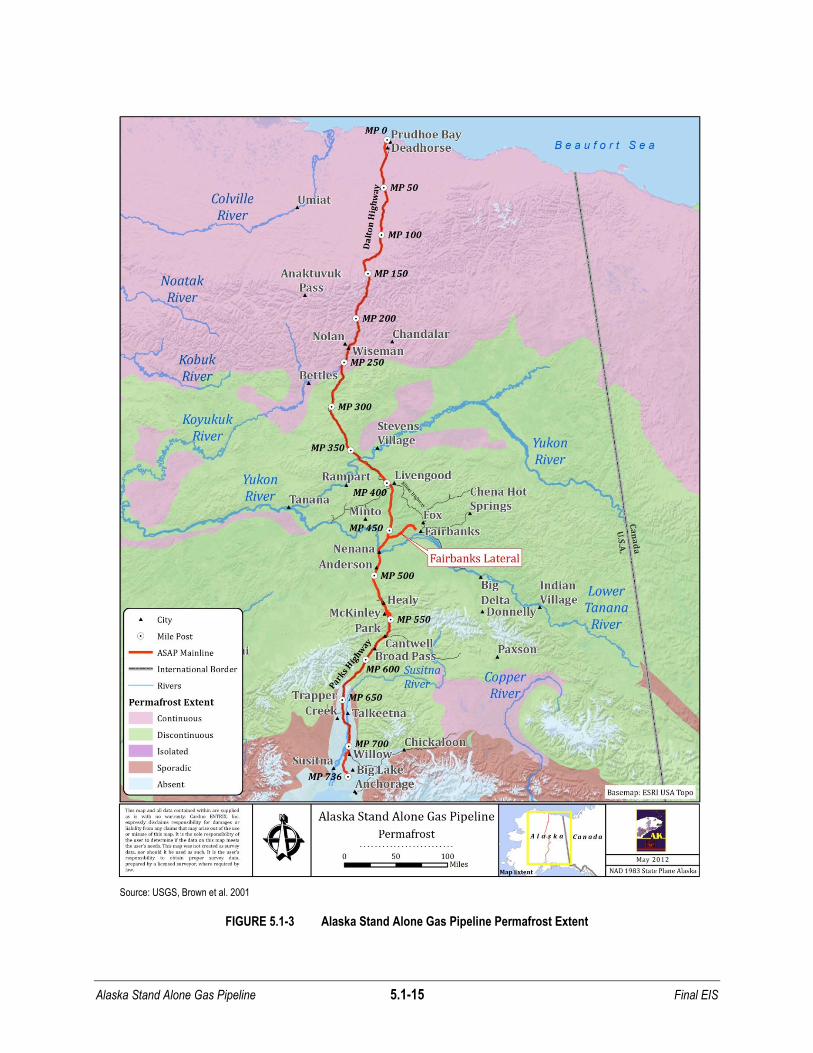
basis of its extent, permafrost is classified as continuous (covering from 90 to 100 percent of an
area), discontinuous (50 to 90 percent coverage), sporadic (10 to 50 percent coverage), or
isolated patches (up to 10 percent coverage) (Brown et al. 1997). For the proposed Project,
permafrost is classified as continuous from approximately MP 0-262, discontinuous from
approximately MP 262-628, and absent from approximately MP 628- 736 (Brown et al. 2001).
The depth of the active seasonal freeze-thaw layer in the proposed Project area ranges from 1
foot to about 15 feet.
Permafrost stability can be disrupted naturally by climate change, forest fires or drainage of
lakes or artificially by human-impacted means. Permafrost degradation occurs as a result of
progressive warming of ice-laden soils resulting in the thawing of near-surface permafrost and
lowering of the permafrost table. Permafrost aggradation is the result of cooling soil
temperatures and the propagation of permafrost. Both degradation and aggradation can be
triggered by natural or artificial influences.
Liquefaction, a geomorphic process closely related to water content in soils, is also a condition
that may be encountered in the proposed Project area. The DGGS (2011) defines liquefaction
as the transformation of saturated, cohesionless soil from a solid to a liquid state as a result of
increased pore pressure and reduced effective stress (in response to severe ground shaking
resulting from an earthquake).
Frost heaving commonly occurs in silt-rich soils (common in areas that have been glaciated).
Frost heaving is caused by the expansion of soil volume due to the formation of ice within pore
spaces, and also by drawing water to the freezing front of ice lenses. If a frozen soil is
subjected to warming, and the contained ground ice melts, the liquid water content in the soil
increases. If the water is prevented from draining due to the presence of underlying permafrost
or other confining layers, the soil may become saturated and its mechanical strength is reduced.
This weakening can be significant in soils composed of loose sand or non-plastic silt when
subjected to cyclic stress induced by seismic vibrations. Thermokarst features are formed by
the melting of ice within a given soil leaving local voids and potentially causing the ground
surface to subside. Subsidence is most pronounced in ice-rich soils, especially those with large
Alaska Stand Alone Gas Pipeline 5.1-14 Final EIS
bodies of ground ice. Generally, frost heave, subsidence, thermokarst features, and solifluction
are more likely to occur in silt and clay-rich soils. Areas of coarse-grained sediment and
bedrock exhibit these features less frequently.
Seismicity
The northern portion of the proposed Project area, from the Beaufort Coastal Plain to the
Brooks Range, experiences regionally low seismicity (Plafker et al. 1994). The Beaufort Coastal
Plain, Brooks Foothills, and Brooks Range ecoregions comprise the Arctic Tundra, which has
experienced three earthquakes in the last 50 years that were greater than magnitude 5.0 within
50 miles of the proposed Project area (AEIC 2011). South of the Yukon River, the proposed
Project would cross two seismic zones that trend northeast through the Ray Mountains
ecoregion, including the Minto Flats and Fairbanks seismic zones. The Minto Flats seismic
zone is a northeast-southwest striking zone of earthquakes between the Tintina Fault to the
north and the Denali Fault to the south. The north end of the Minto Flats seismic zone was the
locality of a magnitude 6.0 earthquake in 1995 (Freymueller et al. 2008). The Fairbanks seismic
zone runs 75 miles from the Alaska Range Foothills to northeast of Fairbanks. No single fault
has been identified as the source of the Fairbanks seismic zone, but rather, the source consists
of a network of northeast trending high angle faults with sinistral and normal displacements
(Kolkeri 2007). The Fairbanks seismic zone has been the locality of many earthquakes
including a magnitude 7.3 in 1904, magnitude 6.1 in 1967, magnitude 5.2 in 1981, and 7.2 in
1947 (AEIC 2011). Two other seismic zones that could generate earthquakes producing strong
ground motion in the proposed Project area are the Rampart and Dall City seismic zones. The
Rampart seismic zone is situated between the Kaltag fault and Tintina fault system, northwest of
Fairbanks. This area was the location of a magnitude 5.0 earthquake about 15 miles south-
southeast of the Village of Rampart in 2003. This earthquake was felt strongly by residents
throughout the area. Eight minutes after the earthquake there was a magnitude 4.3 aftershock.
The largest recorded earthquake in the Rampart seismic zone was a magnitude 6.8 that
occurred in 1968.
North of the Rampart seismic zone is a cluster of earthquake activity known as the Dall City
seismic zone. Very little is known about this seismic zone that generated a magnitude 5.2 in
1969 and five earthquakes greater than magnitude 5.0 in 1985, the largest of which was a
magnitude 6.1 (AEIC 2011). The proposed Project may cross the projection of the Kaltag and
Tintina fault systems, but the location of these faults at the alignment crossing is unknown. The
intermontane region includes the Kobuk Ridges and Valleys, Ray Mountains, Yukon-Tanana
Uplands, and the Tanana-Kuskokwim Lowlands ecoregions. This region has experienced 23
earthquakes in the last 50 years that were greater than magnitude 5.0 within 50 miles of the
proposed Project area (AEIC 2011).
Alaska Stand Alone Gas Pipeline 5.1-15 Final EIS
Source: USGS, Brown et al. 2001
FIGURE 5.1-3 Alaska Stand Alone Gas Pipeline Permafrost Extent

Alaska Stand Alone Gas Pipeline 5.1-16 Final EIS
The Alaska Range Transition has seen the most seismic activity since 1960 with 88
earthquakes greater than magnitude 5.0 within 50 miles of the proposed Project area and
includes the Alaska Range and Cook Inlet Basin ecoregions (AEIC 2011, Figure 5.1-2). A major
fault in the proposed Project area is the Denali Fault. The Denali Fault is several hundred miles
long with movement recorded in several locations along its length (APSC 2007,
Plafker et al. 1994). Two large earthquakes, magnitude 7.2 and 7.9, occurred on the Denali
Fault in 1912 and 2002, respectively. North of the Denali Fault, on the north side of the central
Alaska Range, there is an active, northward-vergent fold and thrust belt called the Northern
Foothills Fold and Thrust Belt. This fold and thrust belt has been active through the last
3 million years, and extends from the area near Mount McKinley to east of the Richardson
Highway (Tok River valley) (Freymueller et al. 2008, Bemis 2010, Figure 5.1-2). Two other
active faults, the Healy Creek fault in the north-central Alaska Range foothills, and larger Castle
Mountain Fault in the Cook Inlet Basin ecoregion, are also located near the proposed Project
area. The Healy Creek fault is a major, steeply north dipping reverse fault that is defined on the
east side by the Nenana River and is part of the Northern Foothills Fold and Thrust Belt. On the
high terrace immediately east of the Nenana River, the Healy Creek Fault forms a prominent
scarp more than 6 miles long. However, it is not clear that the fault continues across the
Nenana River (Bemis 2010). The Castle Mountain Fault is the only known active fault in the
greater Anchorage area with an identified surface rupture. The fault lies along the southern
margin of the Talkeetna Mountains (Freymueller et al. 2008, Figure 5.1-2). Both the 62-mile
long eastern and 39-mile long western parts of the fault are seismically active. The fault
produced light to moderate magnitude 5.7 and 4.6 earthquakes in 1983 and 1996, respectively.
The most recent significant earthquake along the western portion of the fault was about 650
years ago, which suggests the possibility a significant earthquake (~magnitude 6.0) may be
expected in the near future (Hauessler et al. 2002).
Southern Alaska, particularly south of the Chugach Mountains, has experienced considerable
seismic activity in recent history. However, most earthquakes occur along the Alaska-Aleutian
megathrust, which has produced four major earthquakes in recent history, including a
magnitude 8.6 in 1964 (Cohen 1995), a magnitude 7.5 in 1979, a magnitude 7.8 in 1988, and a
magnitude 7.9 in 1987 (AEIC 2011). Surface fault rupture is another potential geologic hazard,
which is defined as the dislocation of the surface of the earth related to motion along the fault at
depth. Ground cracking related to surface fault rupture can occur along the fault and away from
the fault (DGGS 2011).
Glacial Processes
Rocks and sediments are added to glaciers through various processes. Glaciers erode the
terrain principally through two methods: abrasion and plucking. Plucking occurs when
subglacial water penetrates the fractures and freezes, which acts like a lever that loosens the
rock by lifting it and separating the fractures from the bedrock. Abrasion occurs when the rocks
frozen into the bottom of the ice act like grit in sandpaper, resulting in landforms such as U-
shaped valleys, cirques and moraines, and rivers with high sediment content (NSIDC 2011).

Alaska Stand Alone Gas Pipeline 5.1-17 Final EIS
Glacial outbursts, also known as jökulhlaups, occur when the ice dam holding back glacial melt
water fails. What results is a large discharge of melt water that has the potential to affect
infrastructure in its path, including the pipeline (Alden 2012).
Surging glaciers are glaciers that advance rapidly at regular intervals. Some glaciers in full
surge can advance up 100 meters per day (333 ft). Surging glaciers are caused by internal
instabilities within the glacier. Surging glaciers occur in the St. Elias Mountains, eastern
Wrangell Mountains, and Alaska Range, but few, if any, are found in the Chugach Mountains
(Pedersen 1978).
Fluvial Processes
Fluvial processes comprise the motion of sedimentation and erosion on a river bed. In addition
to the effects of normal mechanical erosion, which includes both bank erosion and stream
bottom erosion, running water also has the ability to thaw permafrost. The thawing of
permafrost is evidenced by the existence of taliks, or unfrozen zones, beneath the channels of
all rivers that do not freeze to their bottoms during winter. Where large river channels are
incised within ice-rich and/or relatively unconsolidated sediments, lateral erosion can form
thermo-erosional niches, often greater than 30-feet deep. This process can cause bank
collapse, which often occurs in large blocks along ice wedges. This process occurs widely
along the banks of the Yukon River (French 2007).
Coastal Processes
Coastlines change shape and location in response to natural forces and human activities. Sand
and other materials are moved onto and off of beaches by currents and waves. Seasonal
movement of coastal materials creates broad summer beaches followed by narrow winter
beaches in an annual cycle. During major storms, huge waves and storm surges can move
large amounts of coastal sediments and can flood vast coastal areas in a matter of hours.
Coastlines move as a way to achieve equilibrium with the forces acting against them. Barrier
islands and offshore sand bars move landward and along the coast, driven by long shore
currents. Headlands are eroded back, moving the coast inland. Sediment deposited on river
deltas will act to extend the coast out into the water. Coastlines also move inland in response to
changes in sea level.
Coastal retreat at the northern pipeline terminus has the potential to impact the dock facility
serving the proposed Project, due to the moderate-high rates of erosion and bank retreat in the
Prudhoe Bay area. Prudhoe Bay has experienced effects of northern Alaska's coastal erosion
problem. The pipeline terminus is situated about a half a mile from the nearest shoreline of
Prudhoe Bay and behind an existing central natural gas facility.
5.1.1.3 Paleontological Resources
Paleontological resources are defined as any physical evidence of past life, including fossilized
remains, impressions, and traces of plants and animals. Fossils occur throughout Alaska and
range from single-celled organisms to large vertebrates, including Mesozoic dinosaurs, marine
Alaska Stand Alone Gas Pipeline 5.1-18 Final EIS
reptiles, and Pleistocene megafauna. Paleontological evidence in Alaska varies, and with
respect to the proposed Project area, can be characterized broadly. Fossilized plants of marine
and terrestrial origin, as well as invertebrate and vertebrate animal specimens, have been found
in the area of the proposed Project.
The North Slope is particularly rich in paleontological remains. The oldest fossil recovered from
the North Slope, a tooth plate from a vertebrate fish found in Middle Devonian strata, was dated
at 380 million years ago (Lindsey 1986). Post-Devonian sedimentation on the North Slope has,
in some cases, accumulated up to 20,000 feet of fossil-bearing strata. Marine invertebrate
fossils include bryozoans, brachiopods, pelecypods, gastropods, ostracods, cephalopods,
crinoids, trilobites, belemnites, ammonites, and corals. By the Middle Jurassic and through the
Cretaceous (about 160 to 65 million years ago), trees and terrestrial plants appear throughout
North Slope fossil assemblages, recording transgressions and regressions of ancient seas.
Twelve types of dinosaurs from the Late Cretaceous have been found, most of which were
primarily located along the banks of the Colville River (BLM 2001). Fewer invertebrate fossils
occur in Tertiary beds along the Beaufort Coastal Plain. No fossils are known that date from
Oligocene or Miocene formations.
Marine and terrestrial mammal fossils (such as otter, seal, whale, mammoth, moose, caribou,
musk ox, bison, antelope, camel, horse, and steppe lion) and birds have been found in
Quaternary glacial deposits along the Colville River. Fossils of Pleistocene voles and
megafauna, including mammoth, mastodon, antelope, musk ox, elk, moose, and saber-toothed
cats, have been found in frozen silts and peat bogs along the South Fork Koyukuk, Yukon, and
Tanana rivers in the Ray Mountains. Invertebrate fossils (pelecypods, gastropods, and insects)
also occur in a variety of Quaternary deposits (Péwé 1975).
Paleontological resources along the Sagvanirktok River, located approximately 7-10 miles away
from the proposed Project area, consist of small fossils of invertebrates, shells, and corals found
in the metamorphosed rocks of the Brooks Range. These fossils have been examined and
collected by scientists, particularly by members of the U.S. Geological Survey, over the past 30
years. They provide information useful in dating formations and establishing the geological
sequence related to life forms (Reifenstuhl 1991).
5.1.2 Environmental Consequences
5.1.2.1 No Action Alternative
Under the No Action Alternative, the proposed Project would not be constructed and there
would therefore be no effects to soils or geology.
5.1.2.2 Proposed Action
Anticipated impacts to soils and geology as a result of the proposed Project are related to
pipeline segments and alternatives and above ground facilities. This section identifies general
impacts from construction and operation, and discusses impacts specific to regional geology
and topography, permafrost and soils, material resources, and paleontological resources.
Alaska Stand Alone Gas Pipeline 5.1-19 Final EIS
Construction
Open cut would be the most common method utilized for construction of the pipeline, and is
accomplished by excavating a trench and placing the pipe into position. Excavation is classed
as stripping, ditching, or trenching of rock or borrows. At the compressor station sites, access
roads, and borrow areas, stripping excavation would be used. Stripping excavation consists of
the excavation, removal, and disposal of all surface organic material, silt, and unsuitable
overburden necessary to expose suitable foundation conditions. In situations where topsoil
removal is required, the topsoil would be segregated and saved when practical to aid surface
rehabilitation and future revegetation of the area.
During the geotechnical investigation for the pipeline and possible material source sites, topsoil
will be characterized within the pipeline ROW to develop topsoil segregation requirements for
the construction of the proposed Project. The organic soils typical of many locations on the
North Slope are easily damaged, which can affect the depth of the active layer and thereby, the
depth to permafrost and the drainage patterns of the site. In areas where mineral soils are
exposed, the active layer is likely to be considerably deeper than in areas with good vegetative
cover. These exposed sites are likely the result of frost action resulting in cryoturbation. In
areas of low centered polygons, the ice wedges between the polygons may extend from a few
feet to 20 feet or more in depth. When surface hydrology alters the availability of water on ice
wedges, the result may become high centered polygons with deep fissure between them that
could expose a pipeline. This is also likely to alter vegetative communities towards a dryer
regime. In areas with large rocks mixed with finer material, the frost action may create sorted
circles in which the larger stones are forced upwards to the surface and may disrupt buried
objects. In areas of very coarse material such as along rivers and deltas, there may be no
permafrost and very little vegetation, so disturbance is less likely to have long lasting impacts
(Geisler 2012, Rieger et al. 1979).
Within the ROW, trench excavation would utilize conventional excavation equipment, such as
mechanical ditchers, draglines, dredgers, clams, or backhoes for most of the length of the
Proposed Project except for the first 6 miles. Steeper terrain would require a greater amount of
either cut or fill during construction than in flatter terrain, and would therefore have a greater
impact on the topography because the excavated slope areas could more easily erode.
Normally, steeper terrain causes greater impacts. In these areas, the ROW would be expanded
from 100- to 230-feet wide to allow for excavation into the side slopes of the surrounding area to
minimize erosion.
Any action that involves ground disturbance could create a potential for impacts to
paleontological resources existing in the proposed Project area. Pleistocene fossils discovered
along the TAPS ROW necessitated their removal at the time of discovery, and similar
discoveries along the proposed Project ROW are reasonably likely. Given the variability of the
scientific importance of these resources, the potential for adverse impacts exists which the
AGDC would mitigate, if these resources are discovered as part of the proposed Project.
Alaska Stand Alone Gas Pipeline 5.1-20 Final EIS
Temporary localized drainage pattern alterations (e.g., diversions) could occur during
construction to accommodate pipeline installation and equipment staging. The AGDC proposes
to identify measures that would mitigate long-term impacts to local drainage patterns during
engineering design.
Some areas could require drilling and blasting that would be controlled and monitored. Blasting
could be required to fracture high-density frozen soils or bedrock prior to trench excavation.
Safety-controlled blasting techniques would be used in all situations where blasting is required
within proximity to inhabited areas or existing facilities. A Blasting Control Plan would be
developed to mitigate health, safety, environmental impacts, and notify residents that may live in
the vicinity when blasting activities will occur.
Temporary ice roads and ice pads would be constructed to stage and transport materials and
equipment, which would allow the work to be less disruptive to the proposed Project area.
Although thaw settlement could result if the ice road compaction of vegetation appreciably
decreases the insulating capacity of the active layer (Felix et al. 1992), investigations
addressing ice road impacts show impacts are confined to the vegetative layer, thereby limiting
impacts to soils containing permafrost (Walker et al. 1987).
Wintertime construction offers the ability to reduce the work pad thickness or to eliminate gravel
pads altogether. Access roads to the pipeline are planned and construction methods to
appropriately mitigate these conditions would be defined during detailed engineering. The
construction of gravel pads and roads on permafrost requires a thickness of fill equal to or
greater than the depth of the summer thaw. The addition of fill effectively increases the
insulating capacity of the active layer and prevents destructive thaw settlement (NRC 2003,
Klinger et al. 1983).
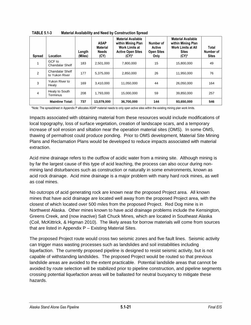
Sands, gravels, rip rap, and other materials would be required at various locations for
infrastructure, pad construction, and production and ancillary facilities along the proposed
Project ROW. Local impacts due to the removal of geological material would occur. The AGDC
has estimated that approximately 13.1 million cubic yards of material may be required for total
proposed Project construction. Of this, approximately 6.18 million cubic yards may be required
for side slope cuts and fills, 90 percent (71 aggregate miles) of which will be used in small
segments between MP 142 and MP 429 of the proposed Project. Sand and gravel sites along
the proposed Project ROW would provide needed borrow material. Although geotechnical data
regarding material availability is in development, a total of 546 existing material sites along the
main alignment have been identified using existing Alaska DOT&PF material site information
sources and are listed in Appendix 6 of the Alaska Stand Alone Gas Pipeline Plan of
Development Revision 1 dated March 2011 (Appendix P). Table 5.1-3 displays material
availability along major sections of the route.
Alaska Stand Alone Gas Pipeline 5.1-21 Final EIS
TABLE 5.1-3 Material Availability and Need by Construction Spread
Spread Location Length (Miles)
ASAP Material Needs (CY)
Material Available within Mining Plan
Work Limits at Active Open Sites
(CY)*
Number of Active
Open Sites Only
Material Available within Mining Plan Work Limits at All
Sites (CY)*
Total Number of
Sites
1 GCF to Chandalar Shelf
183 2,501,000 7,800,000 15 15,800,000 49
2 Chandalar Shelf to Yukon River
177 5,375,000 2,850,000 26 11,950,000 76
3 Yukon River to Healy
169 3,410,000 11,050,000 44 26,050,000 164
4 Healy to South Terminus
208 1,793,000 15,000,000 59 39,850,000 257
Mainline Total: 737 13,079,000 36,700,000 144 93,650,000 546
*Note: The spreadsheet in Appendix P allocates ASAP material needs to only open active sites within the existing mining plan work limits.
Impacts associated with obtaining material from these resources would include modifications of
local topography, loss of surface vegetation, creation of landscape scars, and a temporary
increase of soil erosion and siltation near the operation material sites (OMS). In some OMS,
thawing of permafrost could produce ponding. Prior to OMS development, Material Site Mining
Plans and Reclamation Plans would be developed to reduce impacts associated with material
extraction.
Acid mine drainage refers to the outflow of acidic water from a mining site. Although mining is
by far the largest cause of this type of acid leaching, the process can also occur during non-
mining land disturbances such as construction or naturally in some environments, known as
acid rock drainage. Acid mine drainage is a major problem with many hard rock mines, as well
as coal mines.
No outcrops of acid generating rock are known near the proposed Project area. All known
mines that have acid drainage are located well away from the proposed Project area, with the
closest of which located over 500 miles from the proposed Project. Red Dog mine is in
Northwest Alaska. Other mines known to have acid drainage problems include the Kensington,
Greens Creek, and (now inactive) Salt Chuck Mines, which are located in Southeast Alaska
(Coil, McKittrick, & Higman 2010). The likely areas for borrow materials will come from sources
that are listed in Appendix P – Existing Material Sites.
The proposed Project route would cross two seismic zones and five fault lines. Seismic activity
can trigger mass wasting processes such as landslides and soil instabilities including
liquefaction. The currently proposed pipeline is designed to resist seismic activity, but is not
capable of withstanding landslides. The proposed Project would be routed so that previous
landslide areas are avoided to the extent practicable. Potential landslide areas that cannot be
avoided by route selection will be stabilized prior to pipeline construction, and pipeline segments
crossing potential liquefaction areas will be ballasted for neutral buoyancy to mitigate these
hazards.
Alaska Stand Alone Gas Pipeline 5.1-22 Final EIS
The pipeline will be designed to address frost heave potential and other geomorphic processes.
The design model being used to address frost heave will also address future possible changes if
permafrost gets warmer. The Applicant Proposed Mitigation Measures (Section 5.23,
Mitigation) contain provisions for designing the pipeline system to take into account the thermal
regime of the soils and using engineering controls such as insulation and non-frost-susceptible
fill to control the thermal signature of the pipeline. Furthermore, the pipeline monitoring program
will identify changing soil and rock conditions so that corrective actions can be taken before
pipeline integrity is threatened.
Operations
The proposed Project may affect adjacent permafrost by heat transfer. In concept, the pipeline
would be operated at below freezing temperatures in predominantly permafrost terrains, and
above freezing temperatures in predominantly thawed-ground settings. The operating
temperature of the buried pipeline could affect the frozen/thawed nature of the surrounding
subsurface which, in turn, could affect the pipeline trench support conditions. The operating
temperature could also potentially cause surface expression such as local subsidence or heave.
If the pipeline has a higher temperature than the surrounding subsurface environment, it could
create an area of thawed material along the proposed ROW. Frost heave and thaw bulbs
should be mitigated to avoid creating an unstable ground surface that could be prone to impacts
such as erosion.
Conversely, permafrost aggradation could occur in areas where the pipeline is operated at
below-freezing temperatures. This might occur in the discontinuous permafrost zone wherever
the pipeline (operated at or below freezing temperatures) crosses unfrozen ground; there would
be moisture migration towards the pipeline and resulting frost heave when the moisture freezes.
Even in areas where permafrost is absent, ground ice could grow, producing frost heave in
some areas, especially in areas where thawed, fine-grained soils are dominant in the
subsurface. Where the pipeline traverses from unfrozen, stable ground to ice-rich, unstable
ground, or visa-versa, thaw settlement could occur (French 2007). The AGDC proposes to
identify site specific measures to mitigate impacts to permafrost and soils during engineering
design with optimization primarily accomplished by constructing facilities in the winter while the
ground remains frozen.
During operations, maintenance activities would involve maintaining vegetation along the
permanent ROW to a low height to allow for aerial patrol safety inspections. In addition, areas
that were unsuccessfully revegetated would be reseeded with native plant species. No further
impacts to geology and soils are anticipated from these maintenance activities.
Yukon River Crossing Variations
The proposed Project proposes to cross the Yukon River in one of three ways including a
suspension bridge to be constructed (the Applicant’s Preferred Option), the existing highway
bridge (Option 2), or through horizontal directional drilling (HDD) method (Option 3). For the the
Applicant’s Preferred Option, footings and abutments for a new bridge would be constructed
Alaska Stand Alone Gas Pipeline 5.1-23 Final EIS
and would require strict adherence to erosion and sediment control measures. The impacts to
soils and geology would be caused by the excavation needed to place the foundations of the
bridge. However, no permanent structures, such as footings, would be installed within the
Yukon River, which would prevent impacts to soil and geological resources within the river
related to increased sedimentation and accretion, among others. Impacts to soil and geological
from Option 2 would be negligible since there would be no ground disturbance. The feasibility
of Option 3, HDD crossing, is unknown at this time due to the limited soil information. Further
study is required to investigate and evaluate the in-situ soils, analyze scour limitations, and
address seismic concerns. Nevertheless, gravel pads placed on both sides of the river would
require strict adherence to sedimentation and erosion control. A discussion of the potential
impacts of using the HDD crossing method on waterbodies and wetlands is provided in Sections
5.2 Water Resources and 5.4 Wetland Resources.
5.1.2.3 Denali National Park Route Variation
The proposed Denali National Park Route Variation would follow in close proximity to the Parks
Highway corridor through Denali NPP primarily from MP 540 to MP 555. The route would
typically be placed within the road ditch near the toe of the road slope on the east side of the
road. Localized erosion control methods would be required to control erosion along roadside
ditches and retaining walls may need to be constructed along portions of the roadway. . AGDC
is currently evaluating the feasibility of using HDD to construct the pipeline beneath the steep
slope up to MP 541 to mitigate visual impacts to the slope. It is not known whether the soils in
this area are discontinuous permafrost, or non-permafrost. Geotechnical studies will be
required to characterize local soils. Work along the route variation would require the disposal of
a significant volume of asphalt that would be disposed of in compliance with ADEC regulations.
South of the Canyon commercial area, the pipeline would cross the Nenana River on an existing
pedestrian/bicycle bridge and enter the Denali NPP. The pipeline would pass under the Nenana
River a second time as a buried crossing at McKinley Village and would continue south along
the Parks Highway ROW. During construction related asphalt removal, only one lane of the
traveled roadway would be utilized.
The first river crossing would not require excavations as the pipeline would be attached to an
existing bridge. However, the buried river crossing would have benches prepared for equipment
to use HDD techniques.
5.1.3 References
AEIC. See Alaska Earthquake Information Center.
AGDC. See Alaska Gasline Development Corporation.
Alaska Division of Geological and Geophysical Surveys (DGGS). 2011. Guidebook to geologic
hazards in Alaska. Website: (http://www.dggs.alaska.gov/sections/engineering/
geohazards/glossary.php) accessed September 14, 2011.

Alaska Stand Alone Gas Pipeline 5.1-24 Final EIS
Alaska Earthquake Information Center (AEIC). 2011. Website: (http://www.aeic.alaska.edu).
Alaska Gasline Development Corporation (AGDC). 2011. Alaska Stand Alone Gas Pipeline.
Plan of Development Revision 1. March 2011. Table 7.4-1.
Alden, A. 2012. Jökulhlaups: Glacial Outburst Floods. About.com Geology. Website:
(http://geology.about.com/od/flooding/a/aa_041397jokul.htm).
Alyeska Pipeline Services Company (APSC). 2007. TAPS Final Renewal EIS. Anchorage,
Alaska.
APSC. See Alyeska Pipeline Services Company.
Bemis, S.P. 2010. Moletrackscarps to mountains: Quarternary tectonics of the central Alaska
Range [Ph.D. dissertation]. University of Oregon, 121 pp.
BLM. See United States Bureau of Land Management.
Brown, J., O.J. Ferrians, Jr., J.A. Heginbottom, and E.S. Melnikov. 1997. Circum-Arctic Map of
Permafrost and Ground-Ice Conditions. U.S. Geological Survey Map CP-45.
Brown, J., O.J. Ferrians, Jr., J.A. Heginbottom, and E.S. Melnikov. 1998. Revised February
2001. Circum-arctic map of permafrost and ground ice conditions. Boulder, CO:
National Snow and Ice Data Center/World Data Center for Glaciology. Digital media.
Cohen, S. 1995. The Great Alaska Earthquake, March 27, 1964, Pictorial Histories Publishing
Co., Inc., Missoula, Montana.
Coil, D., E. McKittrick, and B. Higman. 2010. Acid Mine Drainage. Ground Truth Checking.org.
Website: (http://www.groundtruthtrekking.org/Issues/MetalsMining/
AcidMineDrainage.html).
Davis, N. 2000. Permafrost: A Guide to Frozen Ground in Transition, University of Alaska
Fairbanks.
DGGS. See Alaska Division of Geological and Geophysical Surveys.
Felix, N.A., M.K. Raynolds, J.C. Jorgenson, and K.E. DuBois. 1992. Resistance and Resilience
of tundra plant communities to disturbance by winter seismic vehicles. Arctic and Alpine
Research 24(1):69-77.
Ferrians, Jr., O.J. 1965. Permafrost Map of Alaska, Miscellaneous Geologic Investigations
Map I-445, U.S. Geological Survey, Washington, D.C.
Foster, H.L., T.E.C. Keith, and W.D. Menzie. 1994. Geology of the Yukon-Tanana Area of
East-Central Alaska. pp 205240 in Vol. G-1, The Geology of Alaska, in The Geology of
North America, G. Plafker and H.C. Berg (editors), Geological Society of America,
Boulder, Colorado.

Alaska Stand Alone Gas Pipeline 5.1-25 Final EIS
Freymueller, J.T., P.J. Haeussler, R. Wesson, and G. Ekström, Eds. 2008. Active Tectonics
and Seismic Potential of Alaska, American Geophysical Union Geophysical Monograph
Series 179, American Geophysical Union, Washington, D.C,
French, H.M. 2007. The Periglacial Environment, Hoboken, NJ, John Wiley and Sons, pp 187-
267.
Gallant, A.L., E.F. Binnian, J.M. Omernik, and M.B. Shasby. 1995. Ecoregions of Alaska. U.S.
Geological Survey Professional Paper 1567. U.S. Government Printing Office,
Washington D.C., 73pp.
Geisler, E. 2012. Electronic communication.
Haeussler, P.J., R.L. Bruhn, and T.L. Pratt. 2000. Potential seismic hazards and tectonics of
the upper Cook Inlet basin, Alaska, based on analysis of Pliocene and younger
deformation. Geological Society of America Bulletin, v. 112, no. 9, pp 1,414–1,429.
Haeussler, P.J., T.C. Best, and C.F. Waythomas. 2002. Paleoseismology at high latitudes:
Seismic disturbance of upper Quaternary deposits along the Castle Mountain fault near
Houston, Alaska. Geological Society of America Bulletin, v. 114, no. 10 pp 1296-1310.
Hamilton, T.D. 1994. Late Cenozoic glaciation of Alaska Chapter 27. The Geology of Alaska,
The Geology of North America, vol. G-I. Geological Society of America, pp 813-844.
Hamilton, T.D. 2003. Surficial Geology of the Dalton Hwy, 2003, Professional Report 121,
Alaska Division of Geological and Geophysical Surveys.
Klinger, L.F, D.A. Walker, and P.J. Weber. 1983. The Effects of Gravel Roads on Alaskan
Arctic Coastal Plain Tundra, pp 628-633 in Fourth International Conference on
Permafrost, Proceedings, sponsored by University of Alaska and National Academy of
Sciences, July 17-22, National Academy Press, Washington, D.C.
Kolkeri, A., R. Newberry, J. Larsen, P. Layer, and P. Stepp. 2007. Geologic setting of the
Chena Hot Springs geothermal system, Alaska.Thirty-Second Workshop on Geothermal
Reservoir Engineering. Stanford University, Stanford, California. January 22-24.
Website: (http://pangea.stanford.edu/ERE/pdf/IGAstandard/SGW/2007/kolker.pdf).
Kreig, R.A. and R.D. Reger. 1982. Air-Photo Analysis and Summary of Landform Soil
Properties along the Route of the Trans-Alaska Pipeline System, Geologic Report 66,
Alaska Department of Natural Resources, Division of Geological and Geophysical
Surveys, Juneau, Alaska.
Lindsey, K.D. 1986. Paleontological Inventory and Assessment of Public Lands Administered
by Bureau of Land Management, State of Alaska, Bureau of Land Management,
Anchorage, Alaska, pp 35-44, 89-103, 121-251.

Alaska Stand Alone Gas Pipeline 5.1-26 Final EIS
Moore, T.E., W.K. Wallace, K.J. Bird, S.M Karl, C.G. Mull, and J.T. Dillon. 1994. Geology of
Northern Alaska. pp 49-140 in Vol. G-1, The Geology of Alaska, in The Geology of North
America, G. Plafker and H.C. Berg (editors), Geological Society of America, Boulder,
Colorado.
Nowacki, G., P. Spencer, M. Fleming, T. Brock, and T. Jorgenson. 2001. Ecoregions of
Alaska:2001. (Open-File Report 02-297 map) U.S. Geological Survey. Website:
(http://agdc.usgs.gov/ecoreg).
National Resource Council (NRC). 2003. Cumulative Environmental Effects on Oil and Gas
Activities on Alaska’s North Slope. National Academies Press. Washington, D.C.
National Snow and Ice Data Center (NSIDC). 2011. All About Glaciers. National Snow and Ice
Data Center. Website: (http://nsidc.org/glaciers/questions/land.html).
NRC. See National Resource Council.
NSIDC. See National Snow and Ice Data Center.
Pedersen, F. 1978. Surging Glaciers Article #241. Alaska Science forum. Website:
(http://www2.gi.alaska.edu/ScienceForum/ASF2/241.html).
Péwé, T.L. 1975. Quaternary Geology of Alaska, U.S. Geological Survey Professional Paper
835, Washington, D.C.
Péwé, T.L. and R.D. Reger. 1983. Guidebook to Permafrost and Quaternary Geology along
the Richardson and Glenn Highways between Fairbanks and Anchorage, Alaska.
Fourth International Conference on Permafrost, Proceedings, sponsored by University of
Alaska and National Academy of Sciences, July 17-22, National Academy Press,
Washington, D.C.
Plafker, G. and H.C. Berg, Eds. 1994. Neotectonic Map of Alaska pp 49-140 in Vol. G-1, The
Geology of Alaska, in The Geology of North America, G. Plafker and H.C. Berg (editors),
Geologic Society of America, Boulder, Colorado.
Reifenstuhl, R.R. 1991. Paleontological Data from 29 Outcrop Sample of Late Cretaceous to
Jurassic Age, Sagavanirktok Quadrangle, Northeastern Brooks Range, Alaska. Alaska
Division of Geological and Geophysical Surveys.
Rieger, S., D.B. Schoephorster, and C.E. Furbush. 1979. Exploratory Soil Survey of Alaska.
USDA, Soil Conservation Service, Washington, D.C.
Soil Science Society of America. 2011. Soil Science Glossary. Website:
(http://soils.usda.gov/education/facts/soil.html).
United States Bureau of Land Management (BLM). 2001. Dinosaurs on Alaska’s North Slope,
Alaska State Office. Website (http://www.blm.gov/ak/st/en/prog/culture/dinosaurs.html).
Alaska Stand Alone Gas Pipeline 5.1-27 Final EIS
United States Bureau of Land Management and Alaska Natural History Association (BLM and
ANHA). 1993. Riches from the Earth: A Geologic Tour along the Dalton Highway,
Alaska, Anchorage, Alaska.
United States Geological Survey (USGS). 1997. Geologic timescale. Website:
(http://pubs.usgs.gov/gip/fossils/fig15.gif).
Wahrhaftig, C. 1965. Physiographic Divisions of Alaska, U.S. Geological Survey Professional
Paper 482, Washington, D.C.
Walker, D.A, D. Cate, J. Brown, and C. Racine. 1987. Disturbance and recovery of arctic
Alaskan tundra terrain: a review of recent investigations, CRREL Report No. 87-11, pp
24. Hanover, NH: USACE, Cold Regions Research & Engineering Laboratory.

Alaska Stand Alone Gas Pipeline 5.1-28 Final EIS
This page intentionally left blank.