5 36°0'0E 38°0'0E 40°0'0E 42°0'0E g 1 Cizre- a 0 T U R K E ... · mediterranean sea idleb a l -...
1
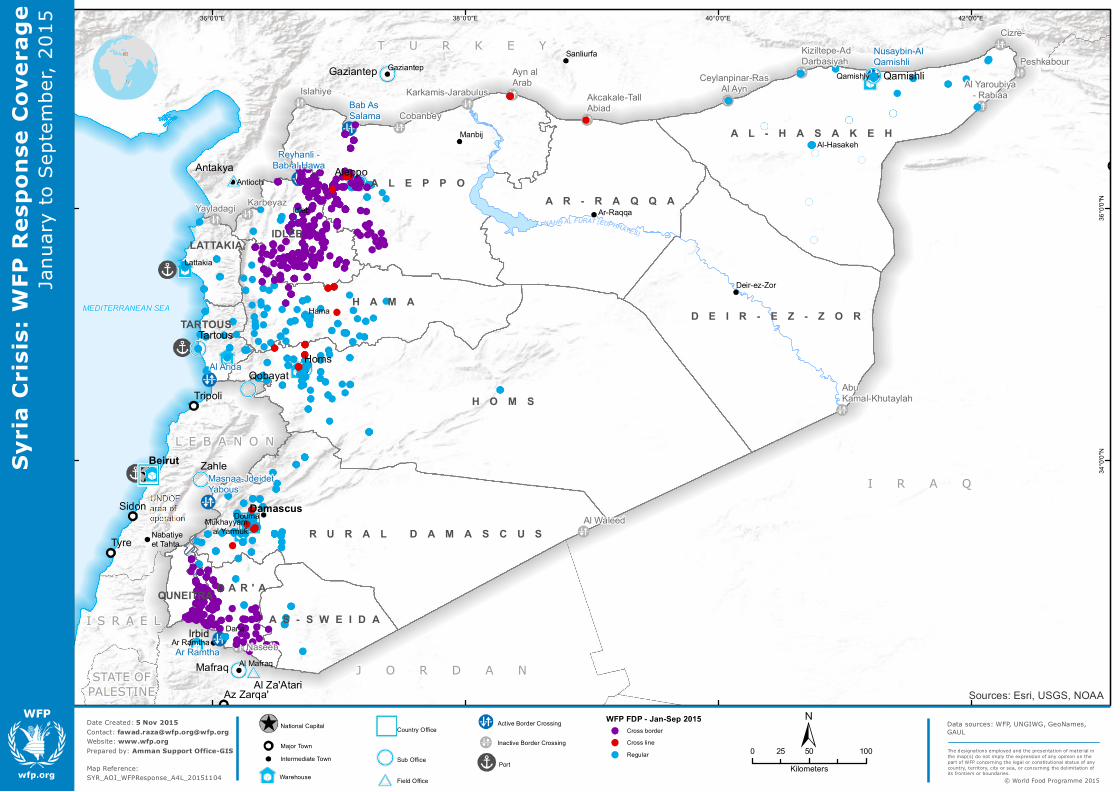
MEDITERRANEAN SEA IDLEB A L - H A S A K E H A R - R A Q Q A AS-SWEIDA QUNEITRA LATTAKIA A L E P P O H A M A H O M S DAR'A D E I R - E Z - Z O R R U R A L D A M A S C U S TARTOUS NAHR AL FU RA T ( EU PHRATES ) STATE OF PALESTINE I R A Q J O R D A N T U R K E Y ISRAEL LEBANON Beirut Damascus Mafraq Gaziantep Zahle Qobayat Tartous Qamishli Al Za'Atari Antakya Reyhanli - Bab al Hawa Bab As Salama Nusaybin-Al Qamishli Ar Ramtha Al Arida Masnaa-Jdeidet Yabous Yayladagi Karkamis-Jarabulus Ayn al Arab Akcakale-Tall Abiad Ceylanpinar-Ras Al Ayn Al Yaroubiya - Rabiaa Al Waleed Abu Kamal-Khutaylah Naseeb Islahiye Cobanbey Kiziltepe-Ad Darbasiyah Cizre- Karbeyaz Peshkabour Nabatiye et Tahta Manbij Mukhayyam al Yarmuk Antioch Deir-ez-Zor Idleb Ar-Raqqa Al-Hasakeh Dar'a Lattakia Hama Douma Qamishly Sanliurfa Al Mafraq Adana Gaziantep Ar Ramtha Sidon Tyre Tripoli Aleppo Az Zarqa' Irbid Homs Sources: Esri, USGS, NOAA 42°0'0"E 40°0'0"E 38°0'0"E 36°0'0"E 36°0'0"N 34°0'0"N Data sources: WFP, UNGIWG, GeoNames, GAUL Date Created: 5 Nov 2015 Contact: [email protected]@wfp.org Website: www.wfp.org Prepared by: Amman Support Office-GIS Map Reference: SYR_AOI_WFPResponse_A4L_20151104 Syria Crisis: WFP Response Coverage January to September, 2015 0 50 100 25 Kilometers The designations employed and the presentation of material in the map(s) do not imply the expression of any opinion on the part of WFP concerning the legal or constitutional status of any country, territory, city or sea, or concerning the delimitation of its frontiers or boundaries. © World Food Programme 2015 National Capital Major Town Intermediate Town Warehouse Country Office Sub Office Field Office Active Border Crossing Inactive Border Crossing Port WFP FDP - Jan-Sep 2015 Cross border Cross line Regular
Transcript of 5 36°0'0E 38°0'0E 40°0'0E 42°0'0E g 1 Cizre- a 0 T U R K E ... · mediterranean sea idleb a l -...
MEDITERRANEAN SEA
IDLEB
A L - H A S A K E H
A R - R A Q Q A
A S - S W E I D AQUNEITRA
LATTAKIA
A L E P P O
H A M A
H O M S
D A R ' A
D E I R - E Z - Z O R
R U R A L D A M A S C U S
TARTOUS
NAHR AL FURAT (EUPHRATES)
STATE OFPALESTINE
I R A Q
J O R D A N
T U R K E Y
I S R A E L
L E B A N O NBeirut
Damascus
Mafraq
Gaziantep
Zahle
Qobayat
Tartous
Qamishli
Al Za'Atari
AntakyaReyhanli -
Bab al Hawa
Bab AsSalama
Nusaybin-AlQamishli
Ar Ramtha
Al Arida
Masnaa-JdeidetYabous
Yayladagi
Karkamis-JarabulusAyn alArab
Akcakale-TallAbiad
Ceylanpinar-RasAl Ayn Al Yaroubiya
- Rabiaa
Al Waleed
AbuKamal-Khutaylah
Naseeb
Islahiye
Cobanbey
Kiziltepe-AdDarbasiyah
Cizre-
Karbeyaz
Peshkabour
Nabatiyeet Tahta
Manbij
Mukhayyamal Yarmuk
Antioch
Deir-ez-Zor
Idleb Ar-Raqqa
Al-Hasakeh
Dar'a
Lattakia
Hama
Douma
Qamishly
Sanliurfa
Al Mafraq
Adana Gaziantep
Ar Ramtha
Sidon
Tyre
Tripoli
Aleppo
Az Zarqa'
Irbid
Homs
Sources: Esri, USGS, NOAA
42°0'0"E40°0'0"E38°0'0"E36°0'0"E
36°0
'0"N
34°0
'0"N
Data sources: WFP, UNGIWG, GeoNames,GAUL
Date Created: 5 Nov 2015Contact: [email protected]@wfp.orgWebsite: www.wfp.orgPrepared by: Amman Support Office-GIS
Map Reference:SYR_AOI_WFPResponse_A4L_20151104
Syria
Cris
is: W
FP R
espo
nse
Cove
rage
Janu
ary
to S
epte
mbe
r, 20
15
0 50 10025Kilometers
The designations employed and the presentation of material inthe map(s) do not imply the expression of any opinion on thepart of WFP concerning the legal or constitutional status of anycountry, territory, city or sea, or concerning the delimitation ofits frontiers or boundaries.
© World Food Programme 2015
National Capital
Major TownIntermediate Town
Warehouse
Country Office
Sub Office
Field Office
Active Border Crossing
Inactive Border Crossing
Port
WFP FDP - Jan-Sep 2015Cross borderCross lineRegular