4(f) De Minimis Documentation for Rand Road over the …f) De Minimis Documentation for Rand Road...
18
4(f) De Minimis Documentation for Rand Road over the Des Plaines River City of Des Plaines, Cook County, Illinois 1. Project Description a. Project Number: P-91-429-09 b. Project Name: Rand Road over Des Plaines River c. Location: City of Des Plaines, Cook County, Illinois d. Project Type: Bridge Replacement e. Project size: 0.36 miles f. Purpose and need of the Project: Replace the bridge that carries Rand Road over the Des Plaines River. The bridge was built in 1928 and has passed its design life of 75 years. Due to the low inventory rating, condition of the superstructure and substructure, the hydraulic deficiency, and cost effectiveness the recommendation is total replacement in order to maintain safety and mobility of Rand Road over the Des Plaines River. g. NEPA Class of Action: CE II h. Project Status: Coordinating land impacts and developing the final project report. 2. Section 4(f) Resources a. Name of Resource: Big Bend Lake Woods and Des Plaines River Trail b. Type of Resource: Forest Preserve and Bike Trail c. Official with Jurisdiction (OWJ): Forest Preserve District of Cook County d. Description of role/significance in the community: The Forest Preserve is located between the Des Plaines River Road on the west, Golf Road on the north, I-294 (Tri-State Tollway) on the east, and is on both sides of Rand Road east of the Des Plaines River. The Des Plaines River Trail follows the banks of the Des Plaines River through Forest Preserve land.
-
Upload
truongdien -
Category
Documents
-
view
246 -
download
3
Transcript of 4(f) De Minimis Documentation for Rand Road over the …f) De Minimis Documentation for Rand Road...
4(f) De Minimis Documentation for Rand Road over the Des Plaines River
City of Des Plaines, Cook County, Illinois
1. Project Description
a. Project Number: P-91-429-09 b. Project Name: Rand Road over Des Plaines River c. Location: City of Des Plaines, Cook County, Illinois d. Project Type: Bridge Replacement e. Project size: 0.36 miles f. Purpose and need of the Project: Replace the bridge that carries Rand Road
over the Des Plaines River. The bridge was built in 1928 and has passed its design life of 75 years. Due to the low inventory rating, condition of the superstructure and substructure, the hydraulic deficiency, and cost effectiveness the recommendation is total replacement in order to maintain safety and mobility of Rand Road over the Des Plaines River.
g. NEPA Class of Action: CE II h. Project Status: Coordinating land impacts and developing the final project
report.
2. Section 4(f) Resources
a. Name of Resource: Big Bend Lake Woods and Des Plaines River Trail b. Type of Resource: Forest Preserve and Bike Trail c. Official with Jurisdiction (OWJ): Forest Preserve District of Cook County d. Description of role/significance in the community: The Forest Preserve is
located between the Des Plaines River Road on the west, Golf Road on the north, I-294 (Tri-State Tollway) on the east, and is on both sides of Rand Road east of the Des Plaines River. The Des Plaines River Trail follows the banks of the Des Plaines River through Forest Preserve land.
4(f) De Minimis Documentation for Rand Road over the Des Plaines River
City of Des Plaines, Cook County, Illinois
3. Description of Intended Section 4(f) Resource Use
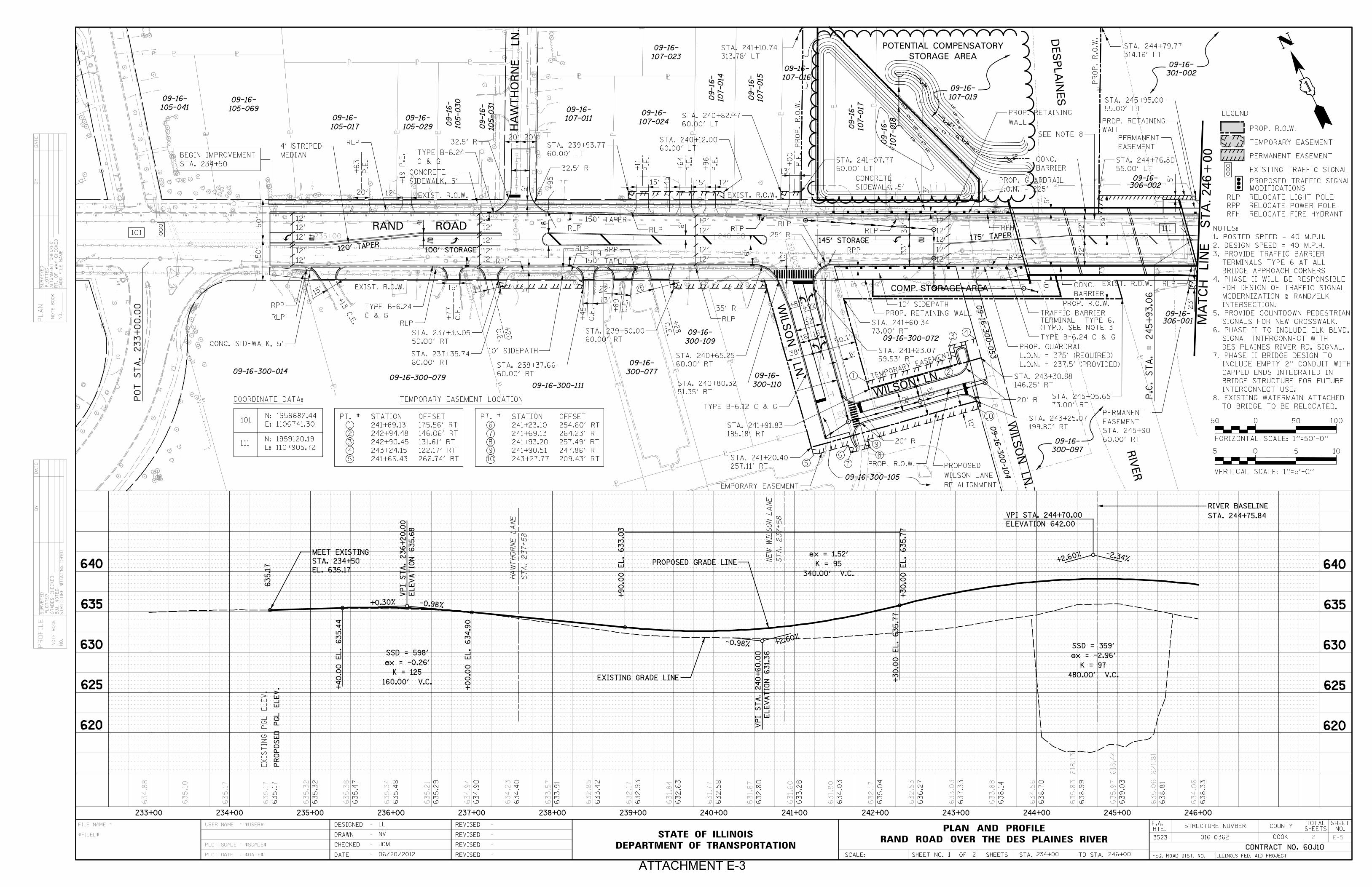
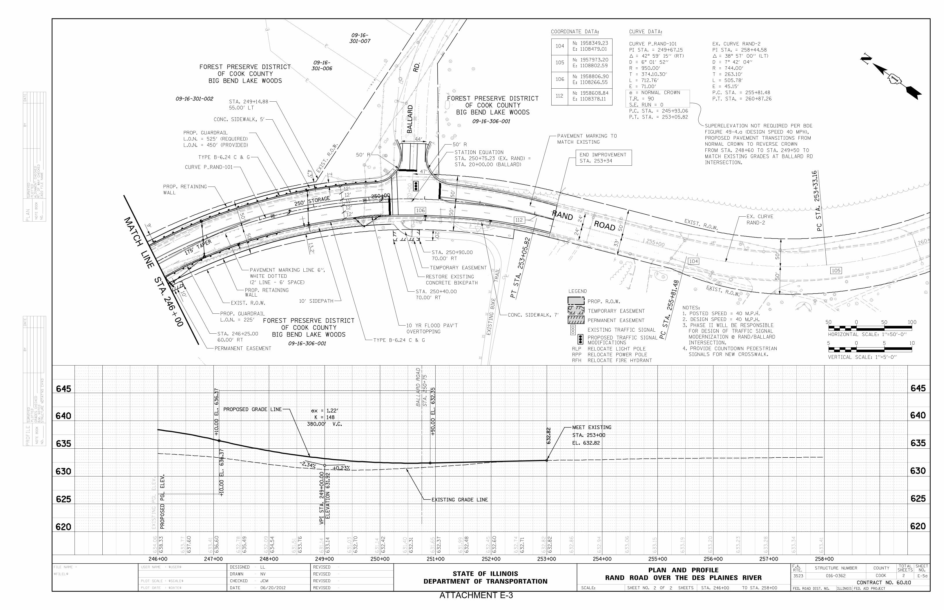
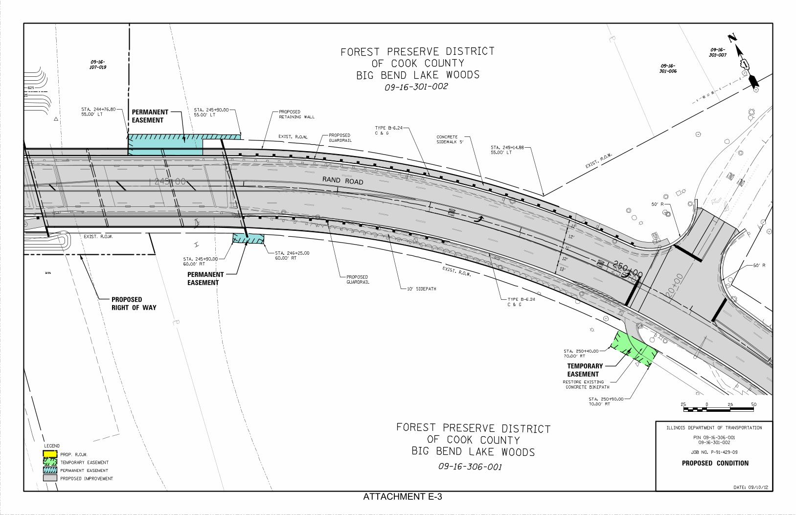
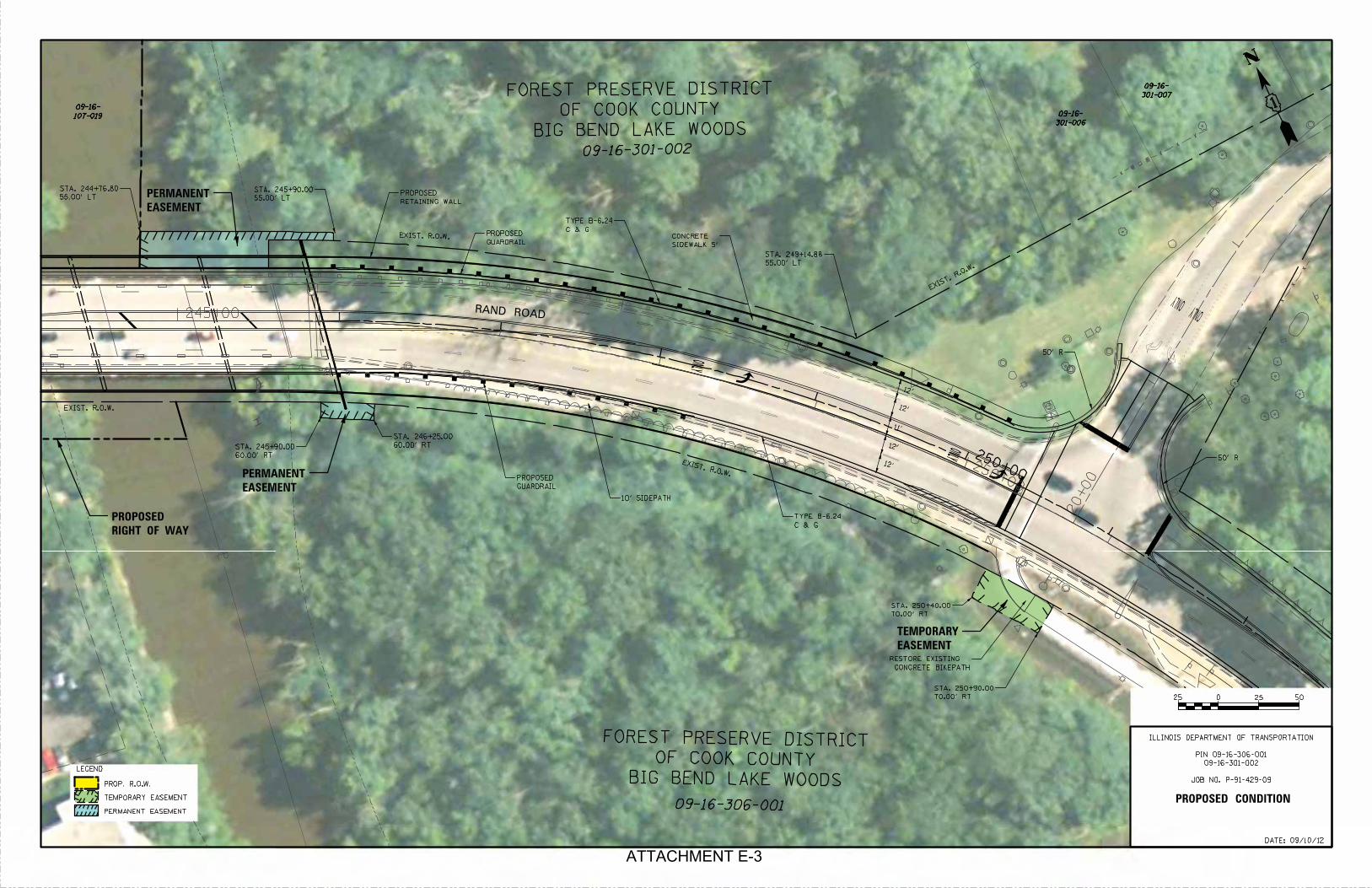
a. Acres to be taken: 0.05 acres of the Big Bend Lake Woods property are needed as a permanent easement in order to construct a wider bridge replacement. 0.02 acres of Big Bend Lake Woods property is needed as temporary easement to reconstruct a short section of the Des Plaines River Trail to match the profile raise of Rand Road and connect into the proposed side path.
b. There will be no negative impact to the FPDCC property in this case. The permanent easements will be needed to construct a wider bridge with different sections within the FPDCC property. The wider bridge provides for a 10’ wide sidepath along the south side of Rand Road which will connect to the Des Plaines River Road bike path at Ballard Road.
c. The existing Rand Road bridge structure currently has a five-foot wide sidewalk, which is not appropriate to accommodate the multiple modes (bikes, pedestrians, etc.) that use the Des Plaines River Trail. Widening the structure to provide a ten-foot shared-use path will greatly enhance all users of the trail.
4. Description of Efforts to Avoid, Minimize, and Mitigate or Enhance the
Resource
a. IDOT is required to accommodate pedestrians/bicyclists adjacent to the state roadway as part of the Complete Street initiative. To minimize impacts on the Forest Preserve property, retaining walls will be installed to keep the majority of the bridge and roadway improvement within the public right-of-way. The roadway cross-section width has been kept to a minimum.
b. A ten-foot shared-use path is proposed along the south side of Rand Road to enhance mobility and safety to and from the Des Plaines River Trail. This provides a connection from the North Elementary School and the Scott Nolan Hospital to the FPDCC’s Des Plaines River Trail. A five-foot sidewalk is proposed along the north side of Rand Road to enhance pedestrian mobility along the corridor.
c. IDOT will secure right-of-way on the northwest quadrant of the bridge for compensatory storage purposes. The portion of this land that falls within the floodway (0.9 acres) is unusable for compensatory storage.
d. List of Commitments for Mitigation or Enhancement: None
5. Evidence of Opportunity for Public Review and Comment:
a. A newspaper ad will be posted to allow the public an opportunity to review and comment on the section 4(f) impacts (See Attachment E-5)

4(f) De Minimis Documentation for Rand Road over the Des Plaines River
City of Des Plaines, Cook County, Illinois
6. Evidence of Coordination with Official(s) with Jurisdiction
a. Copy of IDOT letter to FPDCC dated September 20, 2012. 7. Supporting Documentation
a. Project Location Map (see Attachment E-1) b. Existing Aerial (see Attachment E-2) c. Preliminary Proposed Plan and Profile (see Attachment E-3) d. Photographs of Resource (see Attachment E-4) e. Newspaper Public Comment Display Ad (see Attachment E-5) f. Copies of other correspondence (see Attachment E-6)

ATTACHMENT E-1
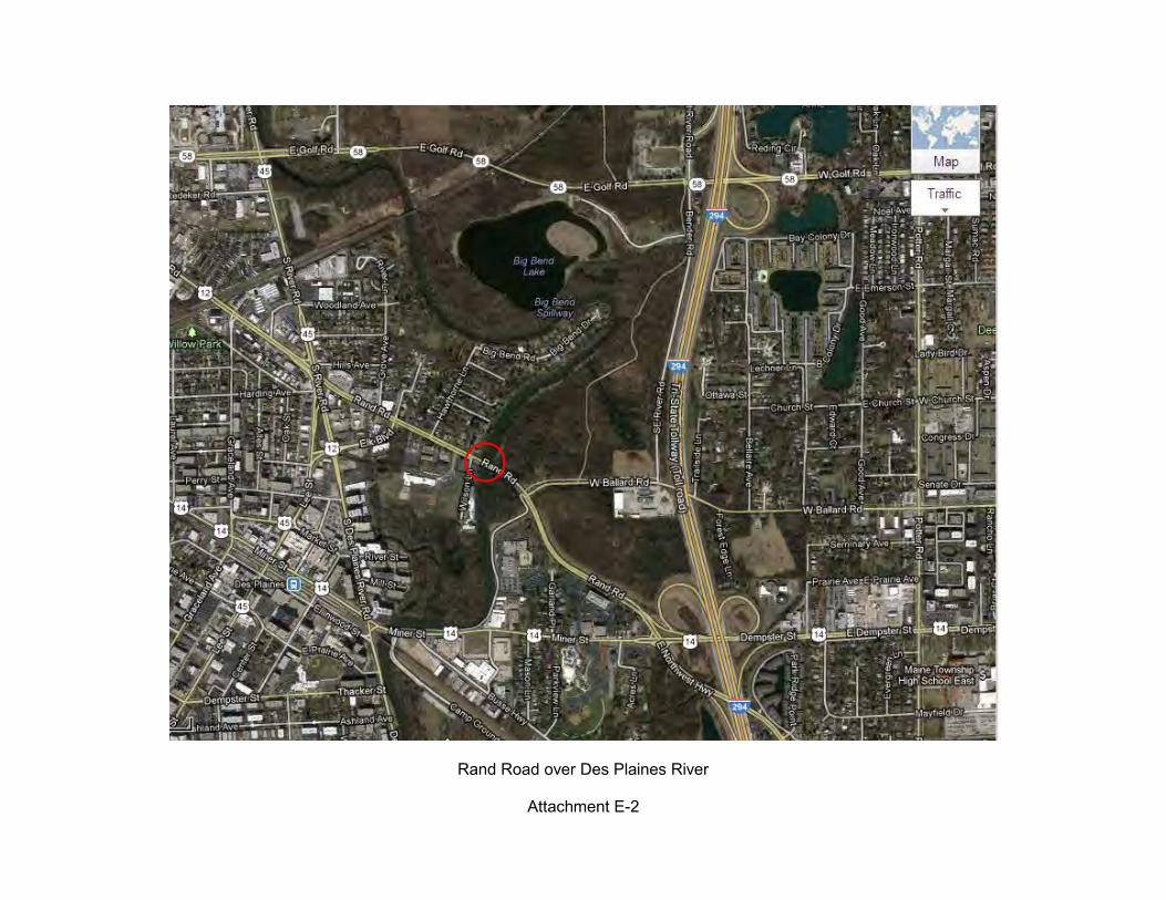
Rand Road over Des Plaines River
Attachment E-2
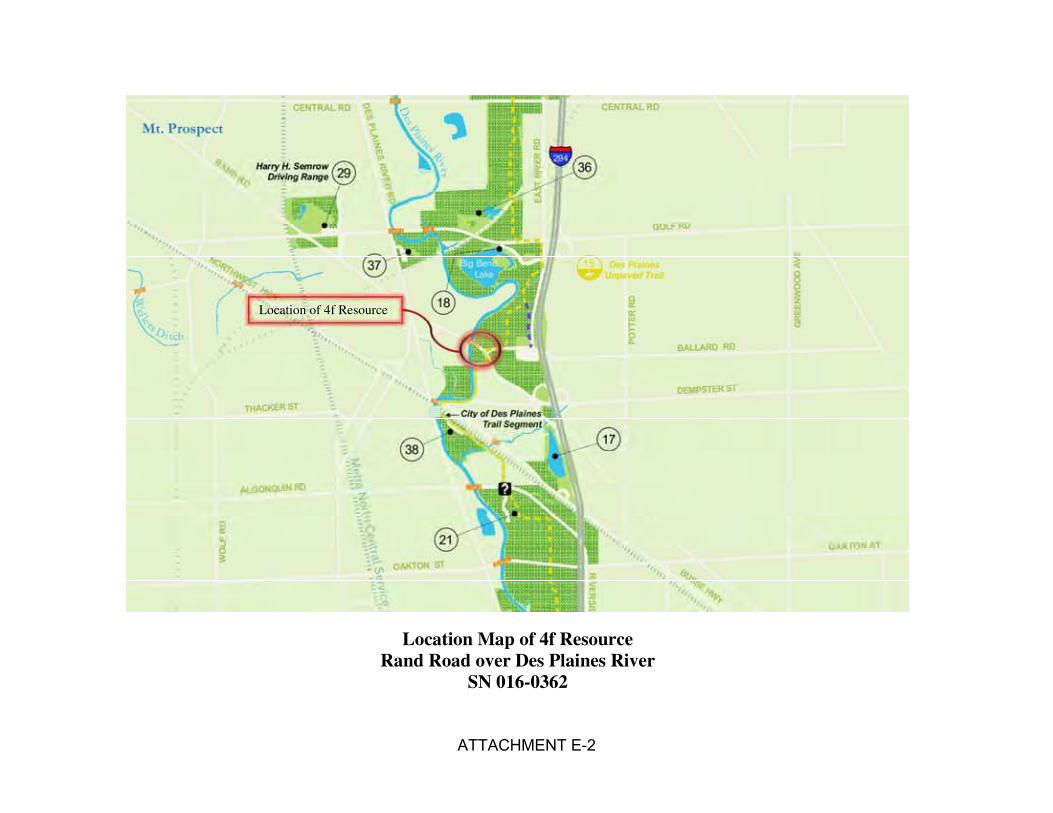
Location Map of 4f Resource Rand Road over Des Plaines River
SN 016-0362
Location of 4f Resource
ATTACHMENT E-2
ASSUME
10"
18"18"
18"
18"
4"
8"
8"
4"
8"
8"
8"
6"
8"8"
8"8"
6"
6"
4"
GA
S
6" GAS
8" GAS
6" GAS
8"
12"
W/ 4
" RES
TRICTOR
SU
RV
EY
ED
PL
OT
TE
D
BY
DA
TE
NO
TE
BO
OK
NO.
PL
AN
ALIG
NM
EN
T
CH
EC
KE
D
RT.
OF
WA
Y
CH
EC
KE
D
CA
DD
FIL
E
NA
ME
PR
OFIL
ES
UR
VE
YE
D
PL
OT
TE
D
GR
AD
ES
CH
EC
KE
D
B.M.
NO
TE
D
ST
RU
CT
UR
E
NO
TA
T’N
S
CH’K
D
BY
DA
TE
NO
TE
BO
OK
NO.
COUNTY
ILLINOIS FED. AID PROJECTFED. ROAD DIST. NO.
TOTAL
SHEETS
SHEET
NO.F.A.
RTE.
CONTRACT NO. 60J10
SHEET NO. OF SHEETS STA. TO STA. SCALE:
DEPARTMENT OF TRANSPORTATION
STATE OF ILLINOIS
FILE NAME $USER$=USER NAME
$SCALE$=PLOT SCALE
$DATE$=PLOT DATE
$FILEL$
= DESIGNED -
-
-
-
REVISED -
-
-
-
REVISED
REVISED
REVISED
DATE
DRAWN
CHECKED
3523 016-0362 COOK
STRUCTURE NUMBER
PLPLP LP LP L P L P L
P L P L
P L P L
P L
P L
PL
PLPLPL
PLPL
PL
PL
PL
PL
PL
PL
PL
PLPLPL
PL
PL
PL
PL
PL
PL
ST
A.
237+58
HA
WT
HO
RN
E L
AN
E
635.1
7
VPI
ST
A.
236
+20.0
0
EL
EV
ATIO
N 635.6
8
+0.30% -0.98%
160.00’ V.C.
K = 125
ex = -0.26’
SSD = 598’
VPI
ST
A.
240
+60.0
0
EL
EV
ATIO
N 631.3
6
-0.98%
340.00’ V.C.
K = 95
ex = 1.52’
480.00’ V.C.
K = 97
ex = -2.96’
SSD = 359’
+40.0
0
EL.
635.4
4
+00.0
0
EL.
634.9
0
+90.0
0
EL.
633.0
3
+30.0
0
EL.
635.7
7
+30.0
0
EL.
635.7
7
ST
A.
237+58
NE
W
WIL
SO
N L
AN
E
VPI STA. 244+70.00
ELEVATION 642.00
+2.60%
+2.60% -2.34%
EL. 635.17
STA. 234+50
MEET EXISTING
233+00 234+00 235+00 236+00 237+00 238+00 239+00 240+00 241+00 242+00 243+00 244+00 245+00 246+00
634.8
8
635.1
0
635.1
7
635.1
7
635.3
2
635.3
8
635.3
4
635.2
1
634.9
4
634.2
3
633.5
7
632.8
5
632.1
7
631.8
4
631.7
7
631.6
7
631.6
0
631.8
0
632.1
7
632.5
3
633.0
3
633.8
8
634.5
6
635.8
3
635.9
7
635.0
6
634.0
6
618.1
3
618.4
4
621.8
1
635.1
7
635.3
2
635.4
7
635.4
8
635.2
9
634.9
0
634.4
0
633.9
1
633.4
2
632.9
3
632.6
3
632.5
8
632.8
0
633.2
8
634.0
3
635.0
4
636.2
7
637.3
3
638.1
4
638.7
0
638.9
9
639.0
3
638.8
1
638.3
3
630
631.2
7
631.2
7
630
628
629
627
626
626
630
629
628
627
626
627
628
629
626
625
625
235+00 240+00 245+00ONLYONLY
ONLY 10
+00
30
+00
50+00
234+00 246+002
1
EXIS
TIN
G
PG
L
EL
EV.
HORIZONTAL SCALE: 1"=50’-0"
1005050 0
05 5 10
VERTICAL SCALE: 1"=5’-0"
6’
12’
12’
12’
12’
6’
20’20’
EXIST. R.O.W.
EXIST. R.O.W.
PROP. R.O.W.
EXIST. R.O.W.
EXIST. R.O.W.
PR
OP.
R.O.W.
STA. 234+50
BEGIN IMPROVEMENT
32’
38’
24’
50’
10’
15’
20’
150’ TAPER
12’
15’15’
+13
C.E.
P.E.
+63
+19
P.E.
14’
12’
12’
12’
12’
12’
12’
12’
12’
12’ 12’
22’
P.E.
+11
P.E.
+64
P.E.
+96
15’ 12’
P.E.
+00
C.E.
+77
C.E.
+20
20’
C.E.
+45 C.E.
+8913’
C.E.
+28
12’
12’
12’
12’
12’
13’
145’ STORAGE175’ TAPER
100’ STORAGE120’ TAPER
8’
12
34
RAND ROAD OVER THE DES PLAINES RIVER
PLAN AND PROFILE
313.78’ LT
STA. 241+10.74
314.16’ LT
STA. 244+79.77
TEMPORARY EASEMENT
PERMANENT EASEMENT
PROP. R.O.W.
LEGEND
101
101
COORDINATE DATA:
E: 1106741.30
N: 1959682.44
50.1’
5
6
7
8
9
10
TEMPORARY EASEMENT LOCATION
5
4
3
2
1
PT. #
10
9
8
7
6
PT. #
243+27.77
241+90.51
241+93.20
241+69.13
241+23.10
STATION
241+66.43
243+24.15
242+90.45
242+94.48
241+89.13
STATION
209.43’ RT
247.86’ RT
257.49’ RT
264.23’ RT
254.60’ RT
OFFSET
266.74’ RT
122.17’ RT
131.61’ RT
146.06’ RT
175.56’ RT
OFFSET
16’16’
+84+92
2
L.O.N. = 237.5’ (PROVIDED)
L.O.N. = 375’ (REQUIRED)
PROP. GUARDRAIL
73.00’ RT
STA. 245+05.65
06/20/2012
105-041
09-16-
105-069
09-16-
105-017
09-16-
105-029
09-16-
105-030
09-16-
105-031
09-16-
107-011
09-16-
107-024
09-16-
107-014
09-16-
107-015
09-16-
107-018
09-16-
107-017
09-16-
107-016
09-16-
107-019
09-16-
09-16-300-072
09-16-300-105
09-16-300-104
09-16-300-053
300-097
09-16-
306-001
09-16-
301-002
09-16-
300-109
09-16-
300-110
09-16-300-077
09-16-
09-16-300-079
09-16-300-111
09-16-300-014
107-023
09-16-
306-002
09-16-
E-5
10’
5’
BARRIER
CONC.
BARRIER
CONC.
20’ R
199.80’ RT
STA. 243+25.07
146.25’ RT
STA. 243+30.88
TYPE B-6.24 C & G
(TYP.), SEE NOTE 3
TERMINAL TYPE 6,
TRAFFIC BARRIER
MEDIAN
4’ STRIPED
C & G
TYPE B-6.24PROP. RETAINING WALL
32.5’ R
32.5’ R
60.00’ LT
STA. 239+93.77
60.00’ LT
STA. 240+82.77
60.00’ LT
STA. 241+07.77
60.00’ LT
STA. 240+12.00
60.00’ RT
STA. 240+65.25
257.11’ RT
STA. 241+20.40
73.00’ RT
STA. 241+60.34
TEMPORARY EASEMENT
35’ R
25’ R
20’ R
185.18’ RT
STA. 241+91.83
51.35’ RT
STA. 240+80.32
59.53’ RT
STA. 241+23.07
50.00’ RT
STA. 237+33.05
60.00’ RT
STA. 237+35.74
60.00’ RT
STA. 238+37.66
60.00’ RT
STA. 239+50.00
L.O.N. = 225’
PROP. GUARDRAIL
RE-ALIGNMENT
WILSON LANE
PROPOSED
10’ SIDEPATH
WALL
PROP. RETAINING
PROP. R.O.W.
10’ SIDEPATH
CONC. SIDEWALK, 5’
SIDEWALK, 5’
CONCRETE
TYPE B-6.12 C & G
SIDEWALK, 5’
CONCRETE
C & G
TYPE B-6.24
COMP. STORAGE AREA
STORAGE AREA
POTENTIAL COMPENSATORY
150’ TAPER
TEMPORARY EASEMENT
PO
T
ST
A.
233
+00.0
0
EASEMENT
PERMANENT
50’
50’
33’
33’
5’
73’
55’
3’
23’
5’
+45
+95
4’
16’
32’
32’
6’
10’
PR
OP.
R.O.W.
HA
WT
HO
RN
E L
N.
DESPL
AIN
ES
RIV
ER
RAND ROAD
WIL
SO
N
LN.
WIL
SO
N
LN.
WILSON L
N.
MA
TC
H
LIN
E S
TA. 246+
00
640
635
630
625
620
LL
NV
JCM
640
635
630
625
620
STA. 244+75.84
RIVER BASELINE
EXISTING GRADE LINE
PROPOSED GRADE LINE
PR
OP
OS
ED
PG
L
EL
EV.
60.00’ RT
STA. 245+90
EASEMENT
PERMANENT
55.00’ LT
STA. 245+95.00
5’
55.00’ LT
STA. 244+76.80
WALL
PROP. RETAINING
111E: 1107905.72
N: 1959120.19
111
RLP
RPP
RELOCATE LIGHT POLE
RELOCATE POWER POLE
RPP
RLPRLP
RLP
RLPRLPRLP RLPRFH
RFH RELOCATE FIRE HYDRANT
RPP
RPP
RPP
RPP
RLP
RLP
RLPRFH
RLP
EXISTING TRAFFIC SIGNAL
MODIFICATIONS
PROPOSED TRAFFIC SIGNAL
P.C.
ST
A.
= 245
+93.0
6
TO BRIDGE TO BE RELOCATED.
8. EXISTING WATERMAIN ATTACHED
INTERCONNECT USE.
BRIDGE STRUCTURE FOR FUTURE
CAPPED ENDS INTEGRATED IN
INCLUDE EMPTY 2" CONDUIT WITH
7. PHASE II BRIDGE DESIGN TO
DES PLAINES RIVER RD. SIGNAL.
SIGNAL INTERCONNECT WITH
6. PHASE II TO INCLUDE ELK BLVD.
SIGNALS FOR NEW CROSSWALK.
5. PROVIDE COUNTDOWN PEDESTRIAN
INTERSECTION.
MODERNIZATION @ RAND/ELK
FOR DESIGN OF TRAFFIC SIGNAL
4. PHASE II WILL BE RESPONSIBLE
BRIDGE APPROACH CORNERS
TERMINALS TYPE 6 AT ALL
3. PROVIDE TRAFFIC BARRIER
2. DESIGN SPEED = 40 M.P.H.
1. POSTED SPEED = 40 M.P.H.
NOTES:
SEE NOTE 8
ATTACHMENT E-3
J
6" GAS
ONLY ONLY
SU
RV
EY
ED
PL
OT
TE
D
BY
DA
TE
NO
TE
BO
OK
NO.
PL
AN
ALIG
NM
EN
T
CH
EC
KE
D
RT.
OF
WA
Y
CH
EC
KE
D
CA
DD
FIL
E
NA
ME
PR
OFIL
ES
UR
VE
YE
D
PL
OT
TE
D
GR
AD
ES
CH
EC
KE
D
B.M.
NO
TE
D
ST
RU
CT
UR
E
NO
TA
T’N
S
CH’K
D
BY
DA
TE
NO
TE
BO
OK
NO.
COUNTY
ILLINOIS FED. AID PROJECTFED. ROAD DIST. NO.
TOTAL
SHEETS
SHEET
NO.F.A.
RTE.
CONTRACT NO. 60J10
SHEET NO. OF SHEETS STA. TO STA. SCALE:
DEPARTMENT OF TRANSPORTATION
STATE OF ILLINOIS
FILE NAME $USER$=USER NAME
$SCALE$=PLOT SCALE
$DATE$=PLOT DATE
$FILEL$
= DESIGNED -
-
-
-
REVISED -
-
-
-
REVISED
REVISED
REVISED
DATE
DRAWN
CHECKED
3523 016-0362 COOK
STRUCTURE NUMBER
PL
PL
PL
PL
ST
A.
250+75
BA
LL
AR
D
RO
AD
632.8
2
VPI
ST
A.
249
+00.0
0
EL
EV
ATIO
N 631.9
2
+0.23%
380.00’ V.C.
K = 148
ex = 1.22’
632.8
2
+10.0
0
EL.
636.3
7
+10.0
0
EL.
636.3
7
+90.0
0
EL.
632.3
5
-2.34%
EL. 632.82
STA. 253+00
MEET EXISTING
246+00 247+00 248+00 249+00 250+00 251+00 252+00 253+00 254+00 255+00 256+00 257+00 258+00
634.0
6
633.7
7
633.4
1
632.7
8
632.0
9
631.5
1
631.1
4
631.0
3
631.1
4
631.4
0
631.6
5
631.9
9
632.4
5
632.7
4
632.8
2
632.8
6
632.9
4
633.0
6
633.1
5
633.1
9
633.2
0
633.2
3
633.2
8
633.3
4
633.4
1
638.3
3
637.6
0
636.6
0
635.4
9
634.5
4
633.7
6
633.1
4
632.7
0
632.4
2
632.3
1
632.3
7
632.4
8
632.6
0
632.7
1
632.8
2
250+00
255+00 260
+00
20
+00
ONLY
ONLY
250+00
255+00 260
+00
TEMPORARY EASEMENT
PERMANENT EASEMENT
PROP. R.O.W.
LEGEND
246+00 258+002 2
50’
50’
50’
50’
47’
50’
33’
50’
50’
EXIST. R.O.W.
EXIST. R.O.W.
20’
EXIS
T.
R.O.W.
9’
7’
24’
44’
250’ STORAGE
175’ T
APER
RAND ROAD OVER THE DES PLAINES RIVER
PLAN AND PROFILE
104
104
COORDINATE DATA:
E: 1108479.01
N: 1958349.23
105E: 1108802.59
N: 1957973.20
CURVE DATA:
EXIS
TIN
G
BIK
E
TR
AIL 105
BIG BEND LAKE WOODS
OF COOK COUNTY
FOREST PRESERVE DISTRICT
2
55.00’ LT
STA. 249+14.88
CONC. SIDEWALK, 5’
06/20/2012
09-16-301-002
09-16-306-001
09-16-306-001
301-006
09-16-
301-007
09-16-
E-5a
TYPE B-6.24 C & G
TYPE B-6.24 C & G
WALL
PROP. RETAINING
WALLPROP. RETAINING
OVERTOPPING
10 YR FLOOD PAV’T
CONC. SIDEWALK, 7’
CONCRETE BIKEPATH
RESTORE EXISTING
50’ R
TEMPORARY EASEMENT
MATCH EXISTING
PAVEMENT MARKING TO
10’ SIDEPATH
PROPOSED GRADE LINE
EXISTING GRADE LINE
11’
10’
60.00’ RT
STA. 246+25.00
70.00’ RT
STA. 250+40.00
70.00’ RT
STA. 250+90.00
STA. 253+34
END IMPROVEMENT
13.2’
RAND ROAD
RD.
BA
LL
AR
D
MA
TC
H
LIN
E ST
A. 2
46+
00
LL
NV
JCM24’
12’
12’
12’
12’
PI STA. = 258+44.58
R = 744.00’
T = 263.10’
L = 505.78’
E = 45.15’
P.C. STA. = 255+81.48
P.T. STA. = 260+87.26
BIG BEND LAKE WOODS
OF COOK COUNTY
FOREST PRESERVE DISTRICT
BIG BEND LAKE WOODS
OF COOK COUNTY
FOREST PRESERVE DISTRICT
EXIST. R.O.W.
50’ R
PR
OP
OS
ED
PG
L
EL
EV.
640
635
630
625
620
645
640
635
630
625
620
645
EXIS
TIN
G
PG
L
EL
EV.
HORIZONTAL SCALE: 1"=50’-0"
1005050 0
05 5 10
VERTICAL SCALE: 1"=5’-0"
PC
ST
A.
255+81.4
8
PC
ST
A.
253
+33.1
6
PERMANENT EASEMENT
PI STA. = 249+67.15
L = 712.76’
E = 71.00’
P.C. STA. = 245+93.06
P.T. STA. = 253+05.82
R = 950.00’
T = 374.10.30’
112
112
E: 1108378.11
N: 1958608.84
SIGNALS FOR NEW CROSSWALK.
4. PROVIDE COUNTDOWN PEDESTRIAN
INTERSECTION.
MODERNIZATION @ RAND/BALLARD
FOR DESIGN OF TRAFFIC SIGNAL
3. PHASE II WILL BE RESPONSIBLE
2. DESIGN SPEED = 40 M.P.H.
1. POSTED SPEED = 40 M.P.H.
NOTES:
L.O.N. = 225’
PROP. GUARDRAIL
L.O.N. = 450’ (PROVIDED)
L.O.N. = 525’ (REQUIRED)
PROP. GUARDRAIL
MODIFICATIONS
PROPOSED TRAFFIC SIGNAL
EXISTING TRAFFIC SIGNAL
RELOCATE LIGHT POLE
RELOCATE POWER POLE
RELOCATE FIRE HYDRANTRFH
RPP
RLP
EX. CURVE RAND-2
RAND-2
EX. CURVE
4.3’
PT
ST
A.
253+05.8
2
CURVE P_RAND-101
CURVE P_RAND-101
E: 1108266.55
N: 1958806.90106
106
STA. 20+00.00 (BALLARD)
STA. 250+75.23 (EX. RAND) =
STATION EQUATION
T.R. = 90
S.E. RUN = 0
e = NORMAL CROWN
INTERSECTION.
MATCH EXISTING GRADES AT BALLARD RD
FROM STA. 248+60 TO STA. 249+50 TO
NORMAL CROWN TO REVERSE CROWN
PROPOSED PAVEMENT TRANSITIONS FROM
FIGURE 49-4.a (DESIGN SPEED 40 MPH),
SUPERELEVATION NOT REQUIRED PER BDE
(2’ LINE - 6’ SPACE)
WHITE DOTTED
PAVEMENT MARKING LINE 6",
ATTACHMENT E-3
ATTACHMENT E-3
ATTACHMENT E-3
PHOTOGRAPHS TAKEN MARCH 2010 BIG BEND LAKE WOODS LOCATED EAST OF DES PLAINES RIVER
Page 1 of 3
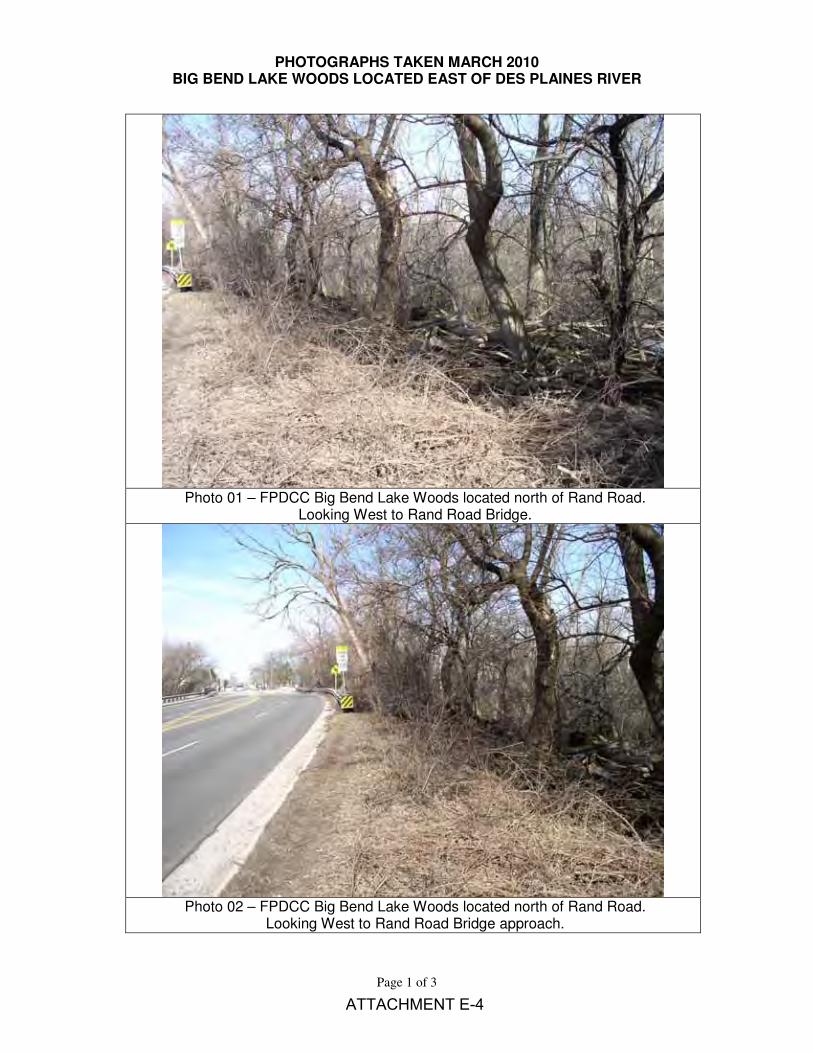
Photo 01 – FPDCC Big Bend Lake Woods located north of Rand Road.
Looking West to Rand Road Bridge.
Photo 02 – FPDCC Big Bend Lake Woods located north of Rand Road.
Looking West to Rand Road Bridge approach.
ATTACHMENT E-4
PHOTOGRAPHS TAKEN MARCH 2010 BIG BEND LAKE WOODS LOCATED EAST OF DES PLAINES RIVER
Page 2 of 3
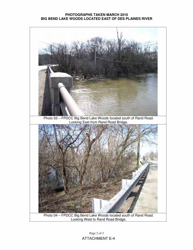
Photo 03 – FPDCC Big Bend Lake Woods located south of Rand Road.
Looking East from Rand Road Bridge.
Photo 04 – FPDCC Big Bend Lake Woods located south of Rand Road.
Looking West to Rand Road Bridge.
ATTACHMENT E-4
PHOTOGRAPHS TAKEN MARCH 2010 BIG BEND LAKE WOODS LOCATED EAST OF DES PLAINES RIVER
Page 3 of 3
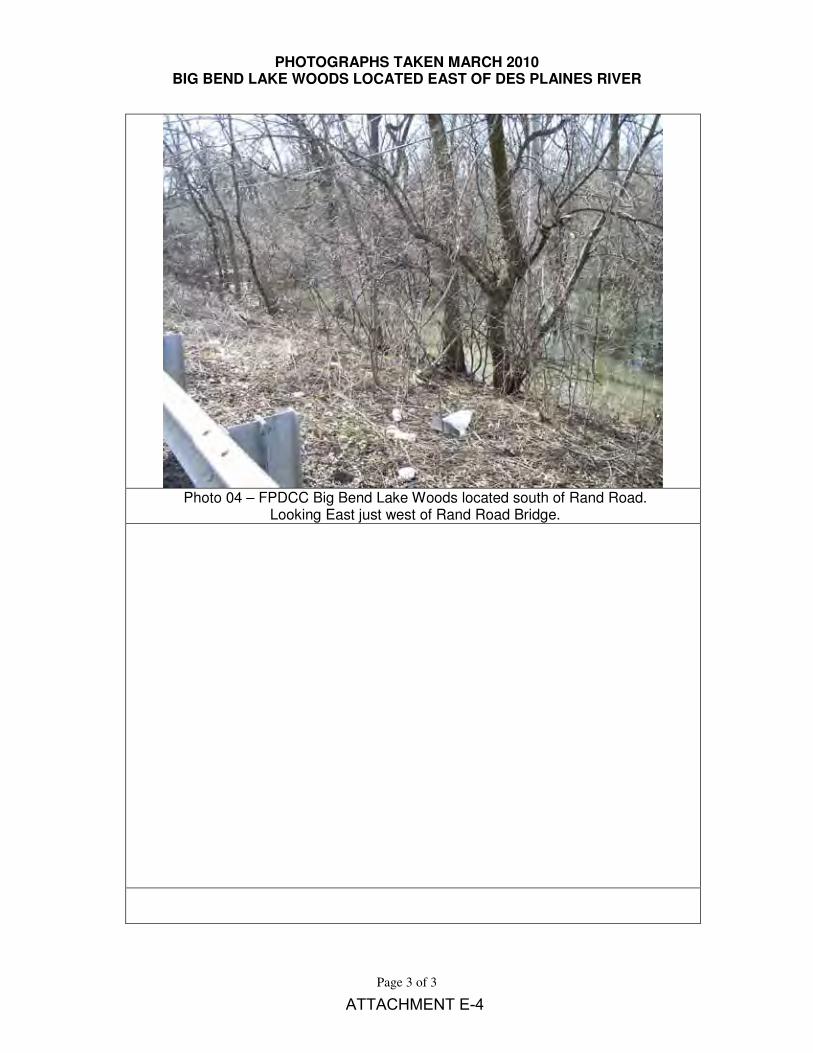
Photo 04 – FPDCC Big Bend Lake Woods located south of Rand Road.
Looking East just west of Rand Road Bridge.
ATTACHMENT E-4
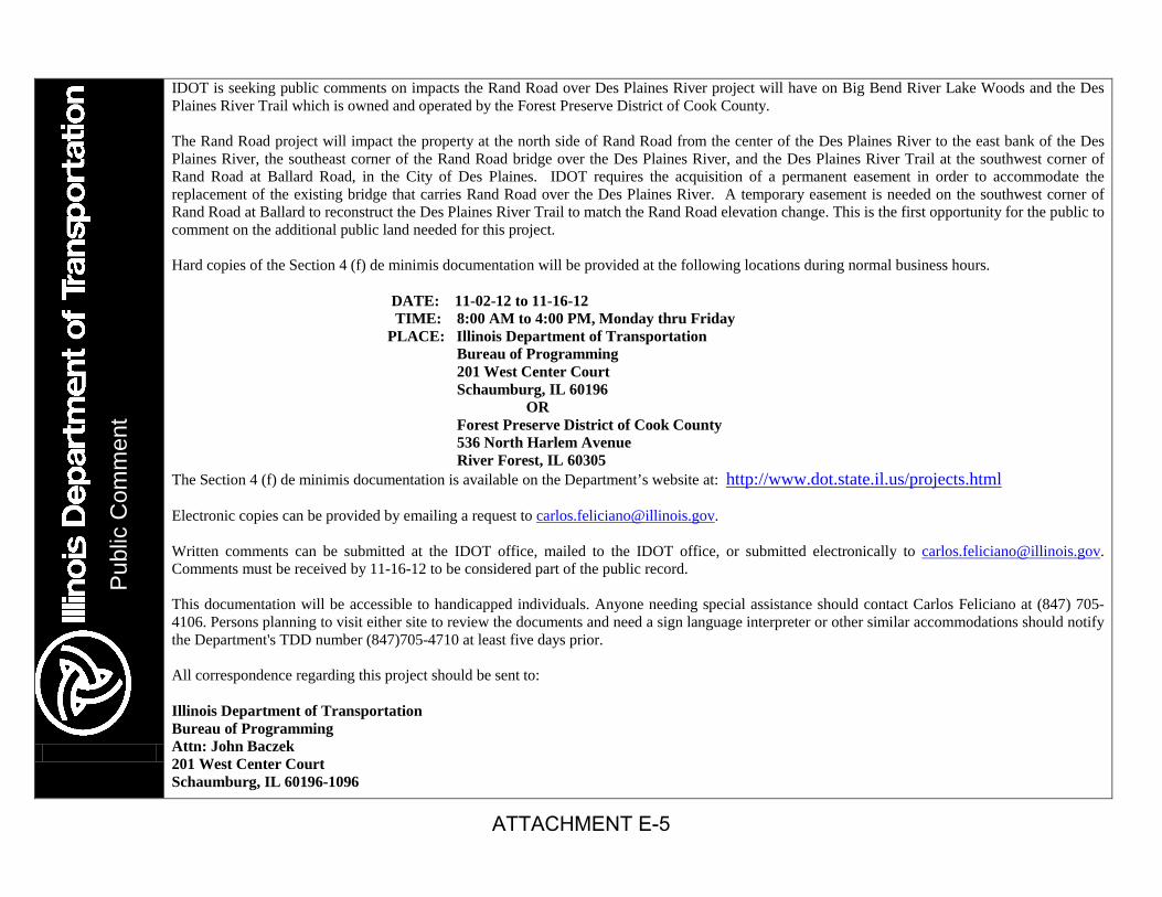
IDOT is seeking public comments on impacts the Rand Road over Des Plaines River project will have on Big Bend River Lake Woods and the Des Plaines River Trail which is owned and operated by the Forest Preserve District of Cook County. The Rand Road project will impact the property at the north side of Rand Road from the center of the Des Plaines River to the east bank of the Des Plaines River, the southeast corner of the Rand Road bridge over the Des Plaines River, and the Des Plaines River Trail at the southwest corner of Rand Road at Ballard Road, in the City of Des Plaines. IDOT requires the acquisition of a permanent easement in order to accommodate the replacement of the existing bridge that carries Rand Road over the Des Plaines River. A temporary easement is needed on the southwest corner of Rand Road at Ballard to reconstruct the Des Plaines River Trail to match the Rand Road elevation change. This is the first opportunity for the public to comment on the additional public land needed for this project. Hard copies of the Section 4 (f) de minimis documentation will be provided at the following locations during normal business hours. DATE: 11-02-12 to 11-16-12 TIME: 8:00 AM to 4:00 PM, Monday thru Friday PLACE: Illinois Department of Transportation Bureau of Programming 201 West Center Court Schaumburg, IL 60196 OR Forest Preserve District of Cook County 536 North Harlem Avenue River Forest, IL 60305 The Section 4 (f) de minimis documentation is available on the Department’s website at: http://www.dot.state.il.us/projects.html Electronic copies can be provided by emailing a request to [email protected]. Written comments can be submitted at the IDOT office, mailed to the IDOT office, or submitted electronically to [email protected]. Comments must be received by 11-16-12 to be considered part of the public record. This documentation will be accessible to handicapped individuals. Anyone needing special assistance should contact Carlos Feliciano at (847) 705-4106. Persons planning to visit either site to review the documents and need a sign language interpreter or other similar accommodations should notify the Department's TDD number (847)705-4710 at least five days prior. All correspondence regarding this project should be sent to: Illinois Department of Transportation Bureau of Programming Attn: John Baczek 201 West Center Court Schaumburg, IL 60196-1096
Pub
lic C
omm
ent
ATTACHMENT E-5

ATTACHMENT E-6
ATTACHMENT E-6

LAND USE REQUEST
INFORMATION FORM 1. Please describe in detail the nature of your request, including, but not limited to: a) Plans depicting and describing the manner in which you intend to alter District property.
The preliminary Proposed Plan & Profile Sheets are attached. The area requested is in the northeast and southeast quadrants of the Rand Road over the Des Plaines River bridge replacement project. The proposed retaining walls minimize impacts to the Forest Preserve District of Cook County due to the profile raise, wider roadway to provide channelization to the relocated Wilson Lane, and the addition of a 5’ sidewalk on the north side and 10’ side path on the south side. The Des Plaines River Trail at the southwest quadrant of Rand Road and Ballard Road will be need to reconstructed to match the profile raise along Rand and match the proposed side path. The total area requested for a permanent easement is 0.05 acres and 0.02 acres of temporary easement.
b) Any and all physical improvements, and structures to be built.
The existing 3-span bridge that carries Rand Road over the Des Plaines River will be removed and replaced. The existing structure was built in 1928 using a concrete tee beam superstructure and due to low sufficiency, operating and inventory ratings; the only option is complete replacement. A continuous 3-span steel beam structure and profile raise utilizing stage construction is recommended.
c) The useful life of the improvements, if any, to be built on District property.
The typical design life of a bridge is 75 years. The existing bridge was built in 1928 and has surpassed the design life of 75 years.
d) The plan for maintenance of the improvement during the useful life of the improvement. The Department inspects structures every two years to determine if any maintenance is
required. The proposed permanent easement is required for construction and regular maintenance of the retaining walls.
2. Please provide detailed maps or plat(s) detailing the location and dimensions of the area that will be impacted by the proposed request. Please include information for both the construction and operation phases of the project.
See attached plans. IDOT’s preliminary construction phasing is expected to be performed in two stages. Each stage would provide one 11-foot lane in each direction will constructing the half of the bridge. This construction phasing is preliminary and is subject to change during a more detailed Phase II (Design and Contract Plan Preparation) evaluation.
ATTACHMENT E-6
3. Please describe, in detail, the manner in which the District will benefit from your proposed request.
The existing structure does not meet hydraulic requirements with overtopping/flooding of the roadway and adjacent Forest Preserve property. Overtopping/flooding should be reduced with the raising of the roadway and providing compensatory storage.
4. Please describe, in detail, the manner in which the public will benefit from this proposed request.
The new bridge will provide a less overtopping/flooding of the roadway and increase safety by introducing channelization to Wilson Lane, a new sidewalk, and a side path that will connect the Des Plaines River Trail to Elk Boulevard located west of the Des Plaines River.
5. Please describe, in detail, which alternatives, if any, have been considered other than the use or acquisition of an ownership interest of District land and why such alternatives are not feasible or practical.
The existing bridge was built in 1928 and has surpassed its 75 year design life. Due to the low sufficiency, operating, and inventory ratings a “No Build” option is not feasible Replacement in-kind would not address the hydraulic deficiencies at the bridge and without widening the structure the safety issues off the bridge would not be addressed. Des Plaines has experienced 8 major river floods in the last 15 years. The flood of 1986 caused 5 deaths, $35 million in damages, and evacuation of 15,000 residents. The preferred alternative to replace the bridge and raise the profile would reduce the amount of flooding at the bridge. The proposed side path from Elk Boulevard to Ballard Road will connect the FPDCC’s existing Des Plaines River Trail and North Elementary School which will provide a safe travel path for children to ride their bikes to school. Additionally, the side path will provide a link between the local planned bike path system to the Des Plaines River Trail. Between 2006 and 2008, 76% (19 of 25) of the crashes were Turning, Rear End, Sideswipe – Same Direction and Angle type crashes. On 1/18/2006, a crash involving a bus occurred at the Wilson Lane intersection. The bus was turning left from Wilson Lane onto Rand Road. This crash resulted in one Type C injury. The proposed westbound left turn at the school entrance should reduce occurrence of these crash types.
6. Please indicate whether all alternatives to the proposed use or acquisition of an interest in District land have been exhausted.
All bridge replacement alternatives to the proposed permanent easement have been exhausted and the area of acquisition has been kept to the minimum in order to construct the replacement bridge. Therefore, avoidance of FPDCC property is not feasible.
ATTACHMENT E-6