47 Gainsford Road, Waltham Forest, E17 Transport Statement · PDF file47 Gainsford Road,...
55
30865/D001a May 2016 Pocket Living Limited 47 Gainsford Road, Waltham Forest, E17 Transport Statement
Transcript of 47 Gainsford Road, Waltham Forest, E17 Transport Statement · PDF file47 Gainsford Road,...
30865/D001a May 2016
Pocket Living Limited
47 Gainsford Road, Waltham Forest, E17
Transport Statement


Contents
1 Introduction ................................................................................ 1
2 Existing Situation ........................................................................ 2
3 Site Accessibility .......................................................................... 4
4 Proposed Development ............................................................... 10
5 Trip Generation & Travel Mode Split ............................................. 12
6 Policy Context ........................................................................... 18
7 Summary and Conclusion ........................................................... 23
Tables
Table 3.1 – PTAL grade summary ................................................................... 5
Table 3.2: - Summary of bus services ............................................................. 6
Table 3.3: - Summary of Victoria Line services ................................................. 7
Table 3.4: - Summary of Overground Line services ........................................... 7
Table 3.5: - Zipcar car club bays .................................................................... 8
Table 5.1 – Existing B1 use Office use comparator sites .................................. 12
Table 5.2 – Existing B1 use Office all mode person trip rates ........................... 12
Table 5.3 – Existing B1 use Office all mode person trips .................................. 12
Table 5.4 – Existing B1 use Office travel mode share ...................................... 13
Table 5.5 – Proposed Residential C3 use comparator sites ............................... 13
Table 5.6 – Proposed Residential C3 use all mode person trip rates .................. 14
Table 5.7 – Proposed Residential C3 use all mode person trips ......................... 14
Table 5.8 – Proposed Residential C3 use travel mode share ............................. 15
Table 5.9 – Net impact of proposed scheme compared to the existing uses ........ 15
Figures
1 Site location plan and local highway network
Drawings
30856/AC/002a
Appendices
A Existing site layout
B PTAL output calculation
C Proposed ground floor layout
D TRAVL data

30865/D001a May 2016
1
1 INTRODUCTION
1.1.1 Transport Planning Practice (TPP) have been commissioned by Pocket Living
Limited to provide transport planning advice in respect of a proposed C3 use
residential development at 47 Gainsford Road, located in the London Borough of
Waltham Forest.
1.2 Background
1.2.1 The site currently comprises a disused council office made up of two buildings, a
permanent two storey brick building and a temporary single storey modular
building. The site has 30 car parking spaces spread over two car parks. The site
is located in a residential area just to the north west of Walthamstow town
centre.
1.3 Proposals
1.3.1 The proposals are to demolish the existing building and construct a Pocket Living
scheme comprising 45 one bedroom flats.
30865/D001a May 2016
2
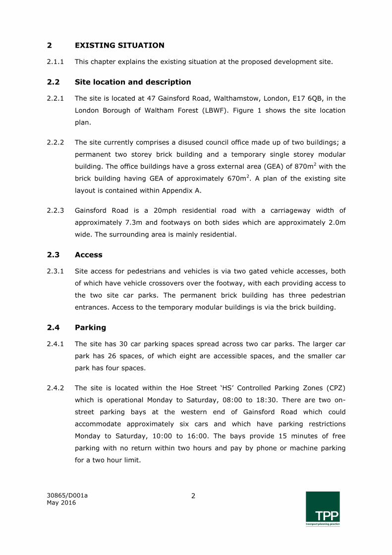
2 EXISTING SITUATION
2.1.1 This chapter explains the existing situation at the proposed development site.
2.2 Site location and description
2.2.1 The site is located at 47 Gainsford Road, Walthamstow, London, E17 6QB, in the
London Borough of Waltham Forest (LBWF). Figure 1 shows the site location
plan.
2.2.2 The site currently comprises a disused council office made up of two buildings; a
permanent two storey brick building and a temporary single storey modular
building. The office buildings have a gross external area (GEA) of 870m2 with the
brick building having GEA of approximately 670m2. A plan of the existing site
layout is contained within Appendix A.
2.2.3 Gainsford Road is a 20mph residential road with a carriageway width of
approximately 7.3m and footways on both sides which are approximately 2.0m
wide. The surrounding area is mainly residential.
2.3 Access
2.3.1 Site access for pedestrians and vehicles is via two gated vehicle accesses, both
of which have vehicle crossovers over the footway, with each providing access to
the two site car parks. The permanent brick building has three pedestrian
entrances. Access to the temporary modular buildings is via the brick building.
2.4 Parking
2.4.1 The site has 30 car parking spaces spread across two car parks. The larger car
park has 26 spaces, of which eight are accessible spaces, and the smaller car
park has four spaces.
2.4.2 The site is located within the Hoe Street ‘HS’ Controlled Parking Zones (CPZ)
which is operational Monday to Saturday, 08:00 to 18:30. There are two on-
street parking bays at the western end of Gainsford Road which could
accommodate approximately six cars and which have parking restrictions
Monday to Saturday, 10:00 to 16:00. The bays provide 15 minutes of free
parking with no return within two hours and pay by phone or machine parking
for a two hour limit.
30865/D001a May 2016
3
2.5 Delivery & servicing
2.5.1 The site uses large up to 1,100 litre wheeled Eurobins for refuse and recycling
waste which are stored in the smaller of the two car parks in the south east
corner of the site. Whilst small vans could enter the site, the site does not
benefit from off-street loading/unloading facilities and there are no dedicated on-
street loading bays nearby. Therefore, refuse collection for the site is expected
to take place on-street where the bins are rolled out by the collection operatives
through the vehicle access, utilising the vehicle crossover to the back of the
collection vehicle.
2.5.2 It is expected that the majority of the deliveries for the office would have been
undertaken by light vans such as Ford Transit type vehicles and consisted office
type deliveries, i.e. stationary and office equipment. It is anticipated that such
deliveries would have taken place on-street, with vehicles stopping on the single
yellow lines across the vehicle accesses or if by small van, within the main site
car park itself.
30865/D001a May 2016
4
3 SITE ACCESSIBILITY
3.1.1 This chapter describes the accessibility of the site by all modes of transport.
3.2 Walking
3.2.1 The site is currently accessed by two gates which also double up as vehicle
accesses. The site is within walking distance of local shops and services on
Palmerstone Road and Forest Road. Walthamstow High Street and The Mall
shopping centre offering high street shopping facilities and local amenities such
as ASDA and Sainsbury’s supermarkets are approximately 600m from the site
which is a seven and half minute walk at an average walking speed of 80m/sec
(3mph).
3.2.2 The footways on Gainsford Road and the neighbouring residential roads are a
minimum of 2.0m wide and there is high level street lighting. At Gainsford
Road’s junction with Palmerstone Road and across all of the side roads along
Palmerstone Road to the town centre, there are raised tables with tactile paving
providing at grade crossing facilities for less ambulant and visibility impaired
people. However, Erskine Road offers a more lightly trafficked route to the town
centre.
3.3 Cycling
3.3.1 Erskine Road is designated on Transport for London’s (TfL) Local Cycling Guide 4
as a quieter road recommended by other cyclists. The A503 Forest Road to the
north and A104 Lea Bridge Road to the south offer routes signed or marked for
cyclists into north and central London respectively.
3.3.2 Walthamstow Central Station has 80 secure and covered cycle parking spaces in
a lockable shed. Access into the shed is via and electronic fob which are available
for annual fee of £10. Also at the station, there is Brompton Bike Hire dock with
20 spaces. Next to the station’s taxi rank on Selbourne Road, there are 14 cycle
stands providing 28 secure cycle parking spaces.
3.3.3 There are a number of Sheffield type stands located on High Street and around
entrances to the main supermarkets.
30865/D001a May 2016
5
3.4 Public transport
PTAL
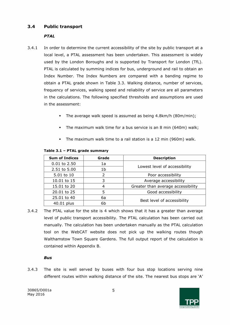
3.4.1 In order to determine the current accessibility of the site by public transport at a
local level, a PTAL assessment has been undertaken. This assessment is widely
used by the London Boroughs and is supported by Transport for London (TfL).
PTAL is calculated by summing indices for bus, underground and rail to obtain an
Index Number. The Index Numbers are compared with a banding regime to
obtain a PTAL grade shown in Table 3.3. Walking distance, number of services,
frequency of services, walking speed and reliability of service are all parameters
in the calculations. The following specified thresholds and assumptions are used
in the assessment:
The average walk speed is assumed as being 4.8km/h (80m/min);
The maximum walk time for a bus service is an 8 min (640m) walk;
The maximum walk time to a rail station is a 12 min (960m) walk.
Table 3.1 – PTAL grade summary
Sum of Indices Grade Description
0.01 to 2.50 1a Lowest level of accessibility
2.51 to 5.00 1b
5.01 to 10 2 Poor accessibility
10.01 to 15 3 Average accessibility
15.01 to 20 4 Greater than average accessibility
20.01 to 25 5 Good accessibility
25.01 to 40 6a Best level of accessibility
40.01 plus 6b
3.4.2 The PTAL value for the site is 4 which shows that it has a greater than average
level of public transport accessibility. The PTAL calculation has been carried out
manually. The calculation has been undertaken manually as the PTAL calculation
tool on the WebCAT website does not pick up the walking routes though
Walthamstow Town Square Gardens. The full output report of the calculation is
contained within Appendix B.
Bus
3.4.3 The site is well served by buses with four bus stop locations serving nine
different routes within walking distance of the site. The nearest bus stops are ‘A’

30865/D001a May 2016
6
and ‘K’ on Palmerstone Road near the junction of Elmsdale Road which are 321m
from the site, approximately a four minute walk. The next nearest stops are ‘N’
and ‘R’ on Forest Road near the junction of Holmes Road which is 430m from the
site, approximately a 5-6 minute walk.
3.4.4 The other two stops are ‘BA’ and ‘BN’ on Hoe Road and stops ‘T’ and ‘U’ on
Mission Grove. Table 3.2 summarises the bus routes and their frequency of
service in the AM and PM peak hours of 08:00 – 09:00 and 17:00 – 18:00
respectively, and the hourly service frequency during the Inter-peak between
09:00 – 17:00. A summary of the hourly service frequency throughout the day
has also been included for Saturday and Sunday.
Table 3.2: - Summary of bus services
Bus Route
Direction (towards)
Monday – Friday
Sat Sun AM
Inter-peak
PM
34 Barnet High Street 7 7 7 6 5
Walthamstow Bus Station 8 8 8 7 5
97 Stratford City Bus Station 8 8 8 8 5
Chingford Station 8 8 8 7 5
123 Redbridge Central Library 6 6 6 5 4
Wood Green Station 6 6 6 5 4
215 Walthamstow Bus Station 3 3 3 3 2
Yardley Lane Estate 3 3 3 3 2
275 Barkingside Tesco 5 6 6 5 3
St James Street Station 6 5 5 5 3
357 Whipps Cross Hospital 4 4 4 4 2
Chingford Hatch 4 4 4 4 2
W11 Walthamstow Bus Station 6 6 6 6 4
Chingford Hall Estate 6 6 6 6 4
W12 Wanstead 3 3 3 3 2
Walthamstow Market 3 3 3 3 2
W15 Homerton Hospital 7 7 7 6 5
Higham Hill 8 8 8 6 5
Total 101 101 101 92 64
3.4.5 Table 3.2 demonstrates that there are 101 bus services per hour between 08:00
– 18:00 Monday to Friday, with 92 and 64 services per hour on Saturday and
Sunday respectively.
30865/D001a May 2016
7
London Underground and Overground Lines
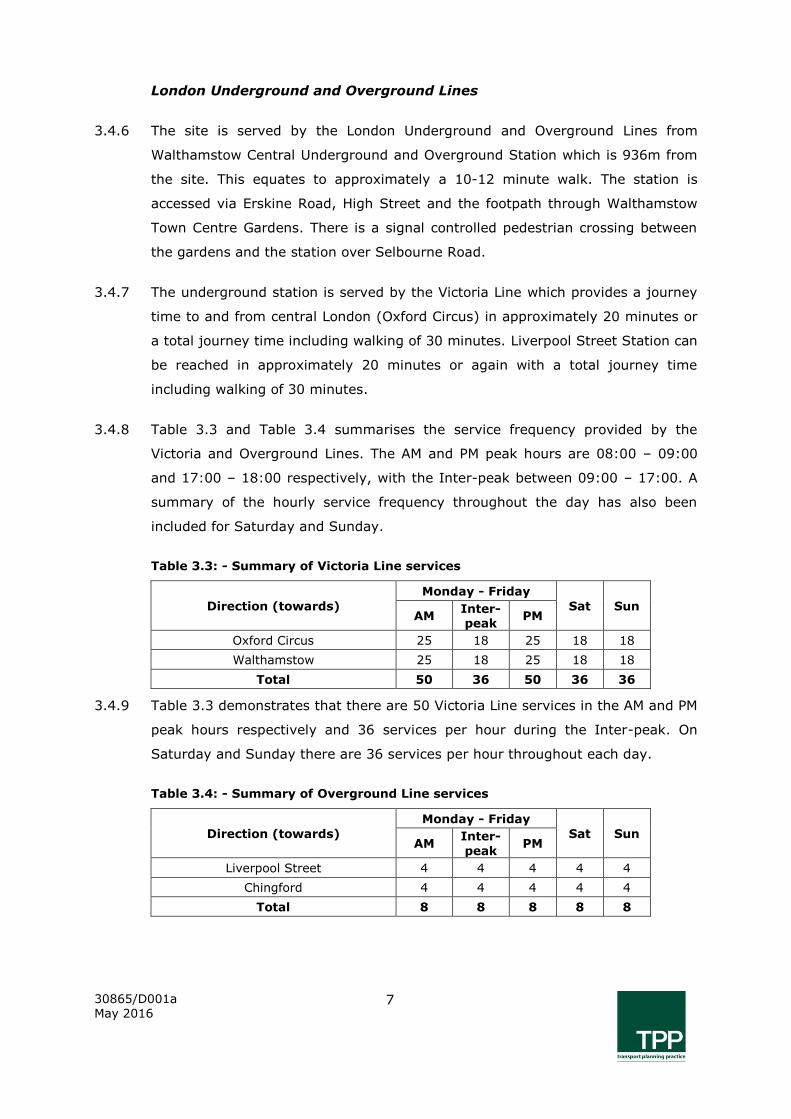
3.4.6 The site is served by the London Underground and Overground Lines from
Walthamstow Central Underground and Overground Station which is 936m from
the site. This equates to approximately a 10-12 minute walk. The station is
accessed via Erskine Road, High Street and the footpath through Walthamstow
Town Centre Gardens. There is a signal controlled pedestrian crossing between
the gardens and the station over Selbourne Road.
3.4.7 The underground station is served by the Victoria Line which provides a journey
time to and from central London (Oxford Circus) in approximately 20 minutes or
a total journey time including walking of 30 minutes. Liverpool Street Station can
be reached in approximately 20 minutes or again with a total journey time
including walking of 30 minutes.
3.4.8 Table 3.3 and Table 3.4 summarises the service frequency provided by the
Victoria and Overground Lines. The AM and PM peak hours are 08:00 – 09:00
and 17:00 – 18:00 respectively, with the Inter-peak between 09:00 – 17:00. A
summary of the hourly service frequency throughout the day has also been
included for Saturday and Sunday.
Table 3.3: - Summary of Victoria Line services
Direction (towards)
Monday - Friday
Sat Sun AM
Inter-
peak PM
Oxford Circus 25 18 25 18 18
Walthamstow 25 18 25 18 18
Total 50 36 50 36 36
3.4.9 Table 3.3 demonstrates that there are 50 Victoria Line services in the AM and PM
peak hours respectively and 36 services per hour during the Inter-peak. On
Saturday and Sunday there are 36 services per hour throughout each day.
Table 3.4: - Summary of Overground Line services
Direction (towards)
Monday - Friday
Sat Sun AM
Inter-
peak PM
Liverpool Street 4 4 4 4 4
Chingford 4 4 4 4 4
Total 8 8 8 8 8
30865/D001a May 2016
8
3.4.10 Table 3.4 demonstrates that there are eight Overground Line services per hour
between 08:00 – 18:00 Monday to Friday and eight services per hour on
Saturday and Sunday throughout the day.
3.5 Local highway network
3.5.1 The site is accessed from Gainsford Road which is a 20mph one-way residential
street accessed from Palmerstone Road to the west and egressed onto Erskine
Road to the west. The street has high level street lighting and on-street car
parking spread out sporadically along the majority of its length. The street is
located within a Controlled Parking Zone (CPZ). Figure 1 shows the local highway
network.
3.5.2 Palmerstone Road links to the A503 Forest Road to the north and the A1006 to
the south via South Grove road. Erskine Road links to Walthamstow town centre
to the south and to Coleridge Road, which is one-way, to the north which then
links back to Palmerstone Road. From Coleridge Road, the A503 Forest Road can
be accessed from Borwick Avenue which is one-way.
3.5.3 A503 Forest Road links to the A406 North Circular Road to the east and the A10
High Road via Monument Way to the west which are both part of Transport for
London’s Road Network (TLRN). The A104 Lea Bridge Road to the south is part
of the London Strategic Road Network (SRN) is accessed via the A1006.
3.6 Car club
3.6.1 There are five car club bays within a 1.0km radius of the site and they are all
operated by Zipcar. Table 3.4 shows the location and distance of these bays
from the site.
Table 3.5: - Zipcar car club bays
Location Distance from the site
Somers Road 300m
Mersey Road 500m
Reness Road 650m
Folkestone Road 1.0km
Hazlewood Road 1.0km

30865/D001a May 2016
9
3.7 Taxi
3.7.1 Walthamstow Central Station has a taxi rank located on Selbourne Road, a
second pick-up and drop-off point is available on Station Approach where a mini-
cab office is located.

30865/D001a May 2016
10
4 PROPOSED DEVELOPMENT
4.1.1 This chapter sets out the proposed development.
4.2 Development proposals
4.2.1 The proposals are to demolish the existing brick and temporary buildings and
construct a four storey C3 use residential building containing 45 one bed flats
including a wheelchair accessible unit. The development will be car-free but
secure and covered cycle parking will be provided along with amenity space on
the site. Appendix C contains a ground floor plan of the proposed development.
4.3 Access
4.3.1 Pedestrian access into the site will be through an at grade entrance on Gainsford
Road. The entrance will lead to a communal area where all parts of the building
can be accessed, including the cycle parking and shared garden.
4.3.2 As part of the development proposals, the two existing vehicular access points
will be removed and the footway reinstated. However, a dropped kerb will run
along the length of the proposed on-street accessible parking bay and in front of
the development’s main entrance and refuse store. This will enable access into
the building for wheelchair users and less ambulant persons from the on-street
accessible parking bay, and enable cyclists to easily mount the footway when
pushing their bicycle into the building. The dropped kerb will also allow for the
movement of bins between the refuse store and the rear of the collection
vehicle.
4.4 Parking
4.4.1 The development itself will be car free and the future residents will be prohibited
from applying for parking permits. However, secure and covered cycle parking
will be provided on the ground floor within the development. Cycle parking will
be provided in-line with the minimum standards set out in Appendix 4 of the
Development Management Policies document. Therefore, a minimum of 45
secure and covered cycle parking spaces will be provided.
4.4.2 One Sheffield cycle stand will be provided close to the building entrance which
will service as visitor cycle parking i.e. two spaces.

30865/D001a May 2016
11
4.4.3 The existing on-street parking arrangement along the site’s frontage includes
three parking bays, two of which are for single vehicle use and the most westerly
bay, able to accommodate two cars. The total combined length of these bays is
approximately 22m.
4.4.4 Removal of the two existing vehicular access points will allow for a more efficient
arrangement of the parking bays and the inclusion of an on-street accessible
parking bay for blue badge holders. The proposed on-street parking layout
shown on drawing number 30865/AC/002a will provide two parking bays each
approximately 11m in length accommodating two cars per bay and a 6.6m long
accessible car parking bay which will be located directly in front of the building
entrance and can be utilised by persons occupying the proposed wheelchair
accessible unit. This arrangement will also provide an 11m long section of single
yellow lining from where deliveries and servicing can take place throughout the
day and used for visitor parking in the evening.
4.5 Delivery & servicing
4.5.1 Following the rearrangement of the on-street parking layout, an 11m long
section of single yellow lining will be created in front of the development from
where delivery and servicing can take place.
4.5.2 The refuse store of the proposed development will be located at the front of the
building and will contain 1,100 litre Eurobins. The bins will be wheeled out to a
dropped kerb for loading onto the refuse collection vehicle as per the existing
situation. The refuse store is situated within 10m of the carriageway.
30865/D001a May 2016
12
5 TRIP GENERATION & TRAVEL MODE SPLIT
5.1.1 This chapter sets out the trip generation of the existing and proposed
development and the travel mode split.
5.1.2 An interrogation of the TRAVL trip generation database has been undertaken in
an attempt to find suitable comparator sites for the existing and proposed
development. The existing site and proposed development TRAVL data is
contained within Appendix D.
5.2 Existing
5.2.1 The comparator sites used for the existing office trip generation of summarised
in Table 5.1. The sites were chosen based on a similar PTAL, location and type of
office.
Table 5.1 – Existing B1 use Office use comparator sites
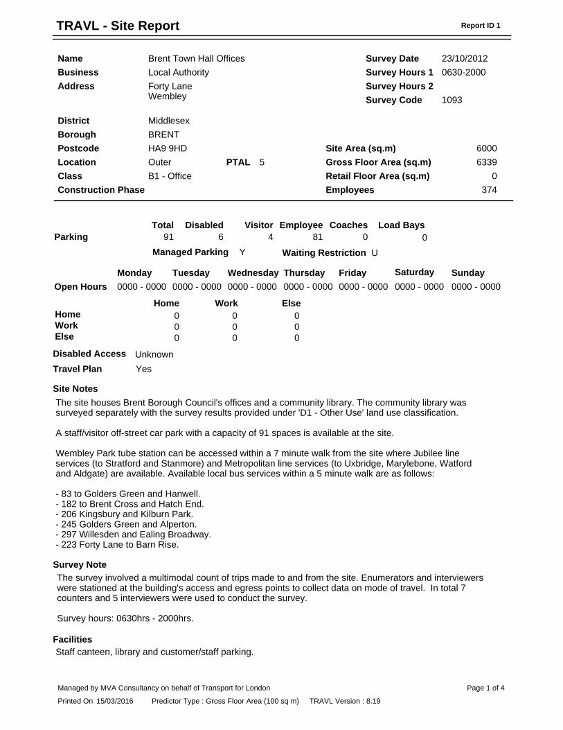
Code Name Address Survey date
1093 Brent Town Hall Offices Forty Lane, Wembley,
HA9 9HD 23/10/2012
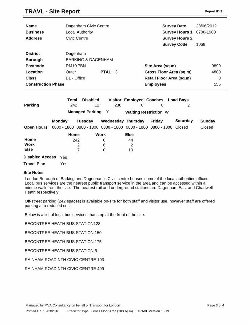
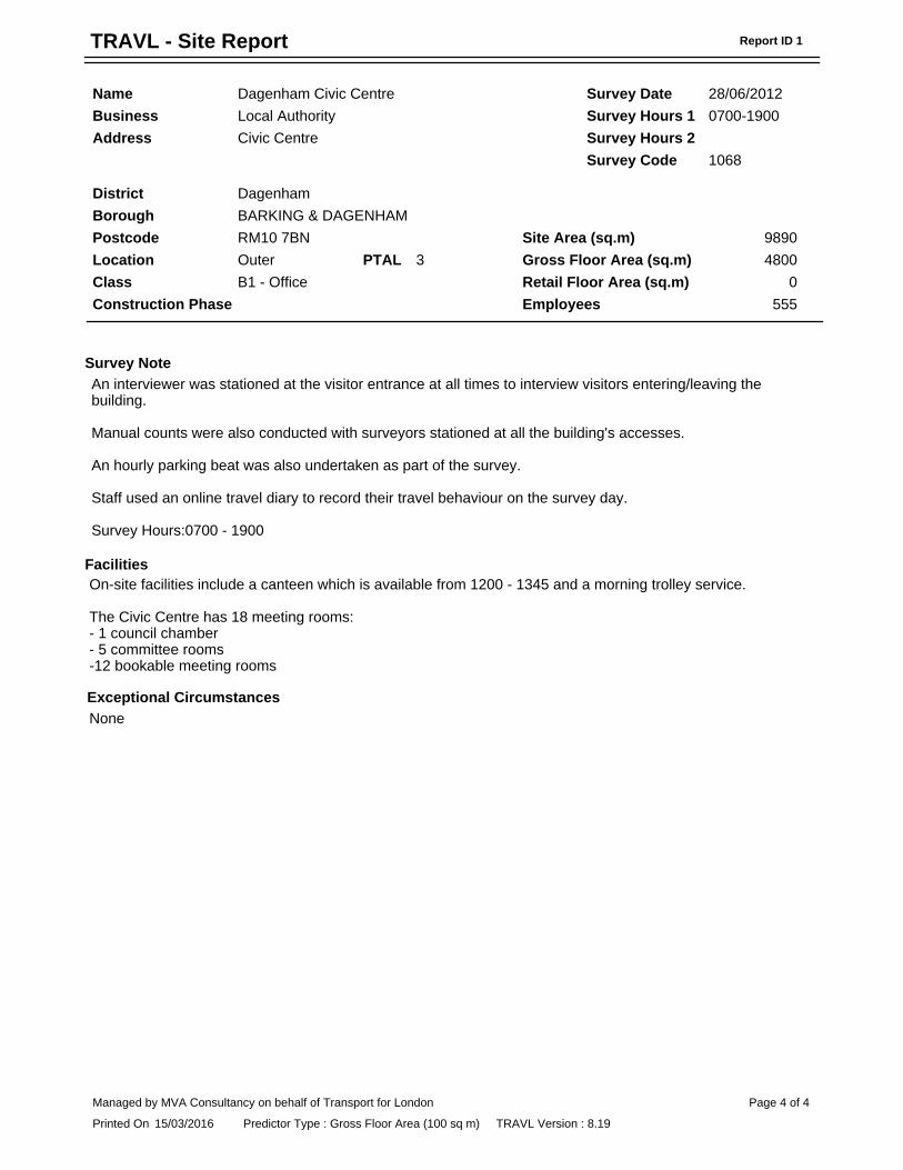
1068 Dagenham Civic Centre Civic Centre, RM10 7BN
28/06/2012
5.2.2 Table 5.2 shows the existing site trip rates for what is generally regarded as the
AM and PM peak hour weekday travel times travel times.
Table 5.2 – Existing B1 use Office all mode person trip rates
Time Arrivals Departures Total
08:00 – 09:00 2.830 0.485 3.304
17:00 – 18:00 0.341 2.280 2.621
5.2.3 The trip rates set out in Table 5.2 have been multiplied by the GEA of 870m2,
divided by 100 to provide the multiplier ratio, i.e. 8.70, used to calculate the
resultant all mode person trips. Table 5.3 shows the estimated all mode person
trip generation for what is generally regarded as the AM and PM peak hour
weekday travel times travel times.
Table 5.3 – Existing B1 use Office all mode person trips
Time Arrivals Departures Total
08:00 – 09:00 25 4 29
17:00 – 18:00 3 20 23
5.2.4 As can be seen from Table 5.3, during the AM peak hour, the office is predicted
to have 25 arrivals and 4 departures resulting in a total trip generation of 29
30865/D001a May 2016
13
person trips. During the PM peak hour, the office is predicted to have 3 arrivals
and 20 departures resulting in a total trip generation of 23 person trips.
Travel mode share
5.2.5 The existing travel mode share to the office has been based on 2011 Census
data Method of travel to work (Workday population) for the mid layer super
output areas of Waltham Forest 011 which the site is located within, and
Waltham Forest 012 which is adjacent. The mode share is summarised in Table
5.4 including the AM and PM peak hour total trip generation.
Table 5.4 – Existing B1 use Office travel mode share
Travel mode Mode share AM peak hour
total trips PM peak hour
total trips
On foot 9.6% 3 2
Cycle 3.1% 1 1
Bus 13.4% 4 3
Underground 18.7% 5 4
Rail 8.9% 3 2
Taxi 0.7% 0 0
Motorcycle 0.8% 0 0
Car driver 41.3% 12 10
Car passenger 2.9% 1 1
Other 0.7% 0 0
Total 100.0% 29 23
5.2.6 Table 5.4 demonstrates that most people travel to and from the site by car, with
underground, bus, rail and on foot having the next highest mode shares.
5.3 Proposed
5.3.1 The sites used for the proposed residential development trip generation is
summarised in Table 5.4. The sites were chosen based on a similar PTAL,
development type and car free nature.
Table 5.5 – Proposed Residential C3 use comparator sites
Code Name Address Survey date
0417 Albion Wharf (Affordable) 6 Hester Road, Lambeth,
SW11 4AL 19/04/2005
0289 Longfield Avenue Longfield Avenue,
Barnet, NW7 07/06/2000
0649 Winchester Mews Winchester Mews, Camden, NW3 3NA
18/09/2008
5.3.2 Table 5.6 shows the proposed development trip rates for what is generally
regarded as the AM and PM peak hour weekday travel times travel times.
30865/D001a May 2016
14
Table 5.6 – Proposed Residential C3 use all mode person trip rates
Time Arrivals Departures Total
08:00 – 09:00 0.240 0.648 0.888
17:00 – 18:00 0.413 0.321 0.735
5.3.3 The trip rates set out in Table 5.6 have been multiplied by the number of
proposed residential units, which equates to 45, to calculate the proposed
development trip generation. Table 5.7 shows the predicted all mode person trip
generation for what is generally regarded as the AM and PM peak hour weekday
travel times travel times.
Table 5.7 – Proposed Residential C3 use all mode person trips
Time Arrivals Departures Total
08:00 – 09:00 11 29 40
17:00 – 18:00 19 14 33
5.3.4 As can be seen from Table 5.7, during the AM peak hour, the proposed
residential development is predicted to have 11 arrivals and 29 departures
resulting in a total trip generation of 40 person trips. During the PM peak hour,
the development is predicted to have 19 arrivals and 14 departures resulting in a
total trip generation of 33 person trips.
5.3.5 The change in the trip tidal direction of flow, particularly in the AM peak hour,
when compared to the existing office development is typical of residential
developments. In the morning, people tend to depart residential developments
rather than arrive at them as per the existing situation.
Travel mode share
5.3.6 The existing travel mode share to the office has been based on 2011 Census
data Method of travel to work for them mid layer super output areas of Waltham
Forest 011, which the site is located within and Waltham Forest 012 which is
adjacent. The mode share is summarised in Table 5.4 including the AM and PM
peak hour total trip generation. As the scheme will be car free, the mode share
percentage for car driver has been shifted pro-rata to all other modes.

30865/D001a May 2016
15
Table 5.8 – Proposed Residential C3 use travel mode share
Travel mode Mode share AM peak hour
total trips
PM peak hour
total trips
On foot 10.3% 4 3
Cycle 5.2% 2 2
Bus 14.0% 6 5
Underground 49.9% 20 17
Rail 15.5% 6 5
Taxi 0.5% 0 0
Motorcycle 1.3% 1 0
Car driver 0.0% 0 0
Car passenger 2.6% 1 1
Other 0.7% 0 0
Total 100.0% 40 33
5.3.7 Table 5.48 demonstrates that most people are predicted travel to and from the
site by underground, with rail, bus and on foot having the next highest mode
share.
5.4 Comparison of existing use and proposed scheme
5.4.1 The net change in multi-modal trips when comparing the current use and
proposed development is summarised in Table 5.9.
Table 5.9 – Net impact of proposed scheme compared to the existing uses
Travel mode AM peak hour
total trips PM peak hour
total trips
On foot 1 1
Cycle 1 1
Bus 2 2
Underground 15 13
Rail 3 3
Taxi 0 0
Motorcycle 1 0
Car driver -12 -10
Car passenger 0 0
Other 0 0
Total 11 10
5.4.2 It can be seen that there is a small increase in the two-way trips during both the
AM and PM peaks for all modes of transport except car trips. The trip generation
assessment shows that there will be 12 and 10 fewer car trips during the AM and
PM peak hours, respectively. This is as a result of the development being car-
free and the residents being prohibited to apply for parking permits to park on
the local roads.
30865/D001a May 2016
16
5.4.3 The site currently acts as an attractor during the AM peak and as a residential
development it will become a generator of trips albeit at a much lower rate. This
tidality would be reversed during the PM peak.
5.4.4 The following paragraphs consider the impact of the proposed development on
the local transport infrastructure.
London Underground
5.4.5 The proposed development is expected to result in an increase of 15 and 13 trips
(two-way) by the London Underground services in the morning and evening peak
hours. The underground stations within walking distance provide access to
approximately 50 trains per hour in both directions during the AM and PM peak
periods. The small increase in the number of underground trips is unlikely to
have a material impact on the available services.
Bus
5.4.6 Within walking distance of the site there are approximately 101 buses per hour
in both directions during the morning and evening peak hours. The trip
generation assessment shows that there would be an increase of two trips by
bus during the AM and PM peak hours which can be accommodated by the large
number of services available.
Cycling
5.4.7 The trip generation assessment shows that there is expected to be an increase of
one cycling trip during the AM and PM peak periods. It is therefore expected that
there will be no negative impact upon local cycle infrastructure.
5.4.8 Notwithstanding the cycle mode trip generation assessment, cycling will be
promoted by provision of secure and covered cycle parking facilities to
encourage more residents to cycle to and from the development. Therefore, it is
anticipated that the number of cycle trips will be higher than those predicted by
this assessment.
Vehicles
5.4.9 The assessment shows that there will be a reduction with regard to the number
of cars on the surrounding highway network with 12 and 10 less trips during the

30865/D001a May 2016
17
AM and PM peak periods respectively. Therefore, the proposals will have no
adverse impact upon the operation of the local highway network.
30865/D001a May 2016
18
6 POLICY CONTEXT
6.1.1 This chapter provides a summary of the relevant transport policy against which
the proposals have been assessed.
6.2 National policy
National Planning Policy Framework
6.2.1 The National Planning Policy Framework (NPPF) was published on the 27th March
2012 and supersedes all previous national planning policy documents such as
PPG13 (Transport). It focuses on a presumption in favour of sustainable
development. One of the core planning principles relates to actively managing
patterns of growth to make the fullest possible use of public transport, walking
and cycling and focusing significant development in locations which are or can be
made sustainable.
6.2.2 The NPPF recognises that the transport system should be balanced in favour of
sustainable transport modes so that people are given a real choice about how
they travel.
6.2.3 Developments should be located and designed where practical to:
Accommodate the efficient delivery of goods and supplies.
Give priority to pedestrian and cycle movements, and have access to
high quality public transport facilities.
Create safe and secure layouts which minimise conflicts between
traffic and cyclists or pedestrians.
Incorporate facilities for charging plug-in and other ultra-low
emission vehicles.
Consider the needs of people with disabilities by all modes of
transport.
6.2.4 In respect of parking standards, the NPPF states that local planning authorities
should take into account the following:
Accessibility of the development.

30865/D001a May 2016
19
Type, mix and use of development.
Availability of and opportunities for public transport.
Local car ownership levels.
Overall need to reduce the use of high-emission vehicles.
6.3 Regional policy
The London Plan, adopted March 2015
6.3.1 The London Plan provides the overall strategic plan for London setting out an
integrated economic, environmental, transport and social framework for the
development of London over the next 20-25 years. The latest version of the
London Plan was published in March 2015.
6.3.2 Policy 6.1 ‘Strategic Approach’ states that the Mayor will work with all relevant
partners to encourage patterns and nodes of development that reduce the need
to travel; improve the capacity and accessibility of public transport, walking and
cycling; support development that generates high levels of trips at locations with
high levels of public transport accessibility and / or capacity; and support
measures that encourage shifts to more sustainable modes.
6.3.3 Policy 6.3 on ‘Assessing Effects of Development on Transport Capacity’ states
that development proposals should ensure that impacts on transport capacity
and the transport network are fully assessed. Transport Assessments should be
provided in accordance with TfL guidance and Travel Plans should be provided
for applications above the thresholds set out in TfL guidance.
6.3.4 The London Plan sets out maximum standards for car parking (Policy 6.13) and
minimum cycle parking standards (Policy 6.9). It is stated that in locations with
high public transport accessibility, car-free developments should be promoted.
6.4 Local policy
Local Plan - Core Strategy, adopted March 2012
6.4.1 Core Strategy Policy CS7: Developing a Sustainable Transport, sets out the core
policies for managing the coordination of land use and transport, developing a
sustainable transport network, managing motorised transport and freight.
30865/D001a May 2016
20
6.4.2 Paragraph 10.18 of the Core Strategy document, outlines LBWF’s policy in
respect of Transport Statements and Travel Plans. It states that: “In order to
fully assess the impacts of new developments on the transport network and to
identify mitigation measures and opportunities to encourage walking, cycling and
public transport use, Transport Assessments and Travel Plans will be required in
support of planning applications. Transport Assessments and Transport
Statements should be prepared in accordance with the requirements and best
practice set out in the DfT Guidance on Transport Assessments (2007) and TfL
Transport Assessment Best Practice, Guidance Document (2010). Further detail
is provided in the Development Management Policies DPD”.
6.4.3 LBWF also has a policy of encouraging and promoting cycling and walking trips.
This is outlined in Paragraphs 10.20 to 10.24. Within the policy document, it
states that half of all trips start and finish in the borough, therefore, there is a
large potential for increasing walking (less than 2km) or cycling (less than 5km)
trips. The policy document recognises that increase in cycling will be beneficial
for the borough as it reduces congestion on the road network, lower emissions,
improve community cohesion and enhance health and fitness levels for
residents.
6.4.4 The council will working with neighbouring boroughs and stakeholders to identify
and implement new routes as well as improve public realm with the aim of
removing barriers to walking and cycling. Provision of parking facilities and
improving safety will ensure that more journeys are undertaken by bike.
Paragraph 10.23 states that council will work with TfL, partners and developers
to maximise cycle facilities in new developments and in the public realm. The
Development Management Policies DPD provides further details on cycling in
LBWF.
6.4.5 Paragraphs 10.34 to 10.37 outline the Council’s approach towards car parking. It
states that: “The availability of parking spaces is a key determinant of mode
choice and car usage. In order to minimise travel by car and encourage the use
of sustainable transport modes instead, the Council anticipates to manage
parking carefully and effectively throughout the Borough”.
6.4.6 For new developments, parking will need to be provided in accordance with the
accessibility of the existing or proposed on-street parking controls of an area and
car-free developments will be promoted.

30865/D001a May 2016
21
Local Plan – Development Management Policies, adopted October2013
6.4.7 The Development Management Policies Development Planning Document (DMP
DPD) was approved for adoption at the Full Council Meeting on 24 October 2013.
It sets out the borough wide planning policies that implement the Core Strategy
and outlines the policy basis for delivering the long-term spatial vision and
strategic place-shaping objectives in Waltham Forest. Policies DM13 - DM16
provide information on the Council's approach to creating a sustainable transport
system for the future of Waltham Forest.
6.4.8 Policy DM13: Co-ordinating Land Use and Transport promotes developments that
are conducive to sustainable travel by guiding development to locations that are
highly accessible. This approach is consistent with the transport strategy outlined
in the London Plan and NPPF.
6.4.9 Policy DM14: Sustainable Transport Network aims to promotes sustainable
choices by addressing congestion and environmental issues as well as to
promote healthier options travel options such as walking and cycling. This DMP
DPD policy outlines how the how the council sets out to achieve the objectives of
Core Strategy Policy CS7 by promoting alternative uses to private car.
6.4.10 In Policy DM15: Managing Motorised Transport, the council outlines their key
steps required to improve the efficiency of highway network (Steps A-E). Step C
is relevant to this application and it states that, the council is “requiring
development proposals to demonstrate that they will not cause any harm or
hindrance to highway safety, in particular to vulnerable road users, and requiring
development to contribute towards improving safety where appropriate”.
DMP DPD’s Policy DM16 outlines the council’s parking policy and seek to manage
the provision of safe and attractive parking facilities. The policy states that the
council encourages “car-free and car-capped development in locations that are
highly accessible by public transport; are accessible to opportunities and
services, and/or have high levels of parking stress”. Furthermore, it mentions
that in car-free developments, space will be limited to those units designed for
disabled people and operational and service needs and occupants of car-free
developments will not be issued with on-street parking permits.
30865/D001a May 2016
22
6.5 Summary
6.5.1 The proposals are consistent with local, regional (London Plan) and national
policy on sustainable transport provision. Car development is car-free which is in
line with local and regional policy requirements for accessible locations. The
development will also provide cycle parking in accordance with adopted policy
which will provide cycling.
30865/D001a May 2016
23
7 SUMMARY AND CONCLUSION
7.1 Summary
7.1.1 Transport Planning Practice have been commissioned by Pocket Living Limited to
provide transport planning advice in respect of a proposed residential
development at 47 Gainsford Road, located in the London Borough of Waltham
Forest.
7.1.2 The site currently comprises a disused council office made up of two buildings, a
permanent two storey brick building and a temporary single storey modular
building. The site has 30 car parking spaces spread over two car parks. The site
is located in a residential area to the north west of Walthamstow town centre.
7.1.3 The proposals are to demolish the existing brick and temporary buildings and
construct a four storey residential building containing 45 one bed flats. The
development will be car-free but secure cycle parking will be provided along with
amenity space on the site.
7.1.4 The site is within walking distance of local shops and services on Palmerstone
Road and Forest Road. Walthamstow High Street and The Mall shopping centre
offering high street shopping facilities and local amenities such as ASDA and
Sainsbury’s supermarkets are approximately 600m from the site.
7.1.5 The site has good access to public transport with a PTAL value of 4. The site is
served by the London Underground and Overground Lines from Walthamstow
Central Underground and Overground Station which is 936m from the site. This
equates to approximately a 10-12 minute walk. The Underground Station is
served by the Victoria Line which provides a journey time to and from central
London (Oxford Circus) in approximately 20 minutes. The site is also well served
by buses with four bus stop locations serving nine different routes within walking
distance of the site.
7.1.6 The site has generally good pedestrian facilities. The footways on Gainsford Road
and the neighbouring residential roads are a minimum of 2.0m wide and there is
high level street lighting. At Gainsford Road’s junction with Palmerstone Road
and across all of the side roads along Palmerstone Road to the town centre,
there are raised tables with tactile paving providing at grade crossing facilities
for less ambulant and visibility impaired people. However, Erskine Road offers a
more lightly trafficked route to the town centre.
30865/D001a May 2016
24
7.1.7 The site is also well suited for cyclists and there are a number of signed on-road
cycle routes, including the A503 Forest Road to the north and A104 Lea Bridge
Road to the south offer routes signed or marked for cyclists into north and
central London respectively. Erskine Road to the east of the site is designated as
a quieter road recommended by other cyclists in TfL’s Local Cycling Guide 4.
7.1.8 The development itself will be car free and the future residents will be prohibited
from applying for parking permits. Secure and covered cycle parking will be
provided on the ground floor for residents. Secure visitor cycle parking will be
located at the front of the property. Cycle parking will be provided in compliance
with local and regional policy.
7.1.9 As part of the development proposals, the two existing vehicular access points
will be removed and the footway reinstated, with the on-street parking
rearranged to create two bays accommodating two cars each and an accessible
parking bay for Blue Badge holders which can be utilised by persons occupying
the wheelchair accessible unit. A dropped kerb will run along the length of the
proposed on-street accessible parking bay and in front of the development’s
main entrance and refuse store. This will enable access into the building for
wheelchair users and less ambulant persons, and enable cyclists to easily mount
the footway when pushing their bicycle into the building. The dropped kerb will
also allow for the movement bins between the refuse store and the rear of the
collection vehicle.
7.1.10 The existing office refuse collection is understood to also take place on Gainsford
Road. Servicing and deliveries for the proposed development would take place
on-street from Gainsford Road as per the current arrangement. Following the
rearrangement of on-street parking layout, a section of single yellow lining will
be provided in front of the building from where delivery and servicing can take
place.
7.1.11 The trip generation assessment demonstrates that the proposed development
would result in a small increase in the two-way trips during both the AM and PM
peaks for all modes of transport except car trips. The trip generation assessment
shows that there will be 12 and 10 fewer car trips during the AM and PM peak
hours, respectively. This is as a result of the development being car-free and the
residents being prohibited to apply for parking permits to park on the local road
network.

30865/D001a May 2016
25
7.1.12 The proposals are compliant with national, regional and local transport policy.
The site is located in a predominantly residential area which has a good level of
access to public transport, particularly by sustainable modes of transport.
7.2 Conclusion
7.2.1 This Transport Statement demonstrates there is no reason not to grant planning
permission for the proposed development on transport grounds.

30865/D001a May 2016
26
Transport Planning Practice
70 Cowcross Street
London EC1M 6EL
020 7608 0008
www.tppweb.co.uk

Figures

Figure 1
Site location & local highway network
Digital Map Data © Collins Bartholomew Ltd (2013)
t: 020 7608 0008
w: www.tppweb.co.uk
70 Cowcross Street
London, EC1M 6EL
transport planning practice
T:\30000_projects\30865 51 G
ainsford Road, W
altham
Forest E17\ACAD
\001.dw
g
Site

Drawings

Appendices

Appendix A
Existing site layout
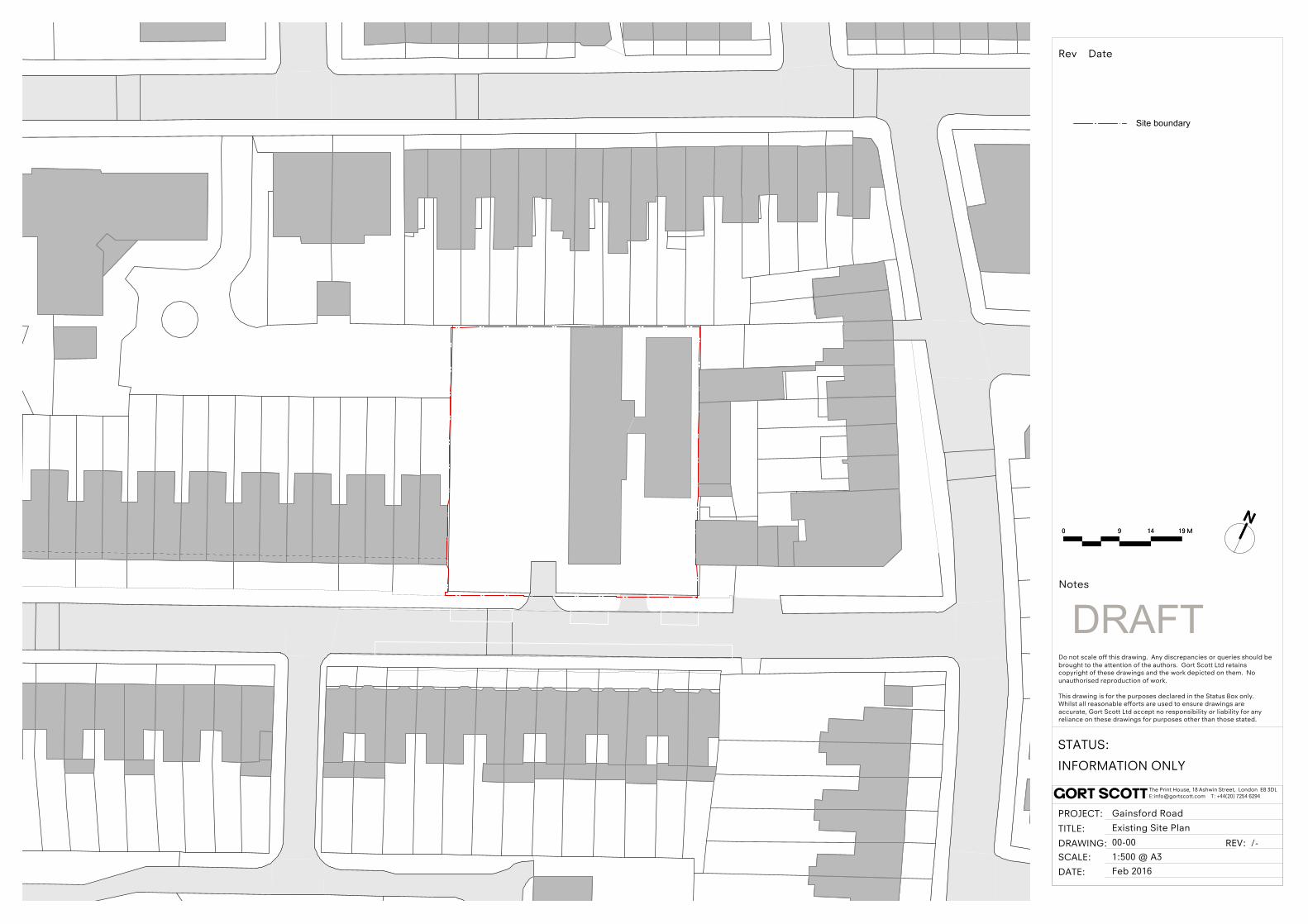
1:500 @ A3
The Print House, 18 Ashwin Street, London E8 3DLE:[email protected] T: +44(20) 7254 6294
Do not scale off this drawing. Any discrepancies or queries should be brought to the attention of the authors. Gort Scott Ltd retains copyright of these drawings and the work depicted on them. No unauthorised reproduction of work.
This drawing is for the purposes declared in the Status Box only. Whilst all reasonable efforts are used to ensure drawings are accurate, Gort Scott Ltd accept no responsibility or liability for any reliance on these drawings for purposes other than those stated.
STATUS:
PROJECT:
TITLE:
DRAWING:
DATE:
Gainsford Road
Feb 2016SCALE:
REV:
INFORMATION ONLY
/-
Existing Site Plan
00-00
gort scott
Rev Date
Notes
DRAFT
0 9 14 19 M0 9 14 19 M
Site boundary

Appendix B
PTAL output calculation

PTAL Calculation Sheet
Main Parmeters
Walk speed (m/min) 80 Input required
Bus reliability (mins) 2 Calculated
Rail reliability (mins) 0.75
Site Details:
Site Services Stop RouteDistance
(m)
Frequency
(services
per hour)
Weighting
Walk
Time
(mins)
SWT
(mins)
Access
Time
(mins)
EDF
(mins)
Accessibility
Index
Bus HOE STREET GREENLEAF RD 357 634.37 4 0.5 7.93 9.50 17.43 1.72 0.86
HOE STREET GREENLEAF RD 34 634.37 7.5 0.5 7.93 6.00 13.93 2.15 1.08
HOE STREET GREENLEAF RD 275 634.37 5 0.5 7.93 8.00 15.93 1.88 0.94
HOE STREET GREENLEAF RD 215 634.37 3 0.5 7.93 12.00 19.93 1.51 0.75
HOE STREET GREENLEAF RD 97 634.37 7.5 0.5 7.93 6.00 13.93 2.15 1.08
FOREST ROAD HOLMES AVE 123 430 5.5 0.5 5.38 7.45 12.83 2.34 1.17
PALMERSTON RD ELMSDALE R W11 320.95 6 0.5 4.01 7.00 11.01 2.72 1.36
PALMERSTON RD ELMSDALE R W15 320.95 7.5 1 4.01 6.00 10.01 3.00 3.00
MISSION GR PALMERSTON RD W12 586.63 3 0.5 7.33 12.00 19.33 1.55 0.78
Rail/LUL/DLR Walthamstow Central Liverpool Street to Chingford 936 4 1 11.70 8.25 19.95 1.50 1.50
Walthamstow Central Chingford to Liverpool Street 936 4 0.5 11.70 8.25 19.95 1.50 0.75
Walthamstow Central Victoria Line 936 26 1 11.70 1.90 13.60 2.21 2.21
Index = 15.47
PTAL = 4
PTAL Range of Index
1a 0.01 - 2.50
1b 2.51 - 5.00
2 5.01 - 10.00
3 10.01 - 15.00
4 15.01 - 20.00
5 20.01 - 25.00
6a 25.01 - 40.00
6b 40.01 +

Appendix C
Proposed ground floor
layout

1280 BK
1280
BK
1280
GR
1280 BK 1280 BK
1280
GR
1280
GR
1280
GR
1280
GR
1280
GR
1280
BK
1280
BK
1280
BR
1280
BR
240
BR
boilerW/D
pre-
plum
bing
for
dish
wash
er
stor
age
600x
600
recy
cle b
ins
bene
ath
600x
600
draw
er u
nit
600x
600
cera
mic
hob &
ove
n60
0x60
0
hood
abo
ve
fridg
e/fre
ezer
600x
600
SVP
clear manoeuvering zoneØ1500mm
boile
rW
/D
pre-plumbingfor
dishwasher
storage600x600
recycle binsbeneath600x600
drawer unit600x600
ceramic hob & oven600x600
hood above
fridge/freezer600x600
SV
P
clea
r man
oeuv
erin
g zo
neØ
1500
mm
boile
rW
/D
pre-plumbingfor
dishwasher
storage600x600
recycle binsbeneath600x600
drawer unit600x600
ceramic hob & oven600x600
hood above
fridge/freezer600x600
SV
P
clea
r man
oeuv
erin
g zo
neØ
1500
mm
boile
rW
/D
pre-plumbingfor
dishwasher
storage600x600
recycle binsbeneath600x600
drawer unit600x600
ceramic hob & oven600x600
hood above
fridge/freezer600x600
SV
P
clea
r man
oeuv
erin
g zo
neØ
1500
mm
boile
rW
/D
pre-plumbingfor
dishwasher
storage600x600
recycle binsbeneath600x600
drawer unit600x600
ceramic hob & oven600x600
hood above
fridge/freezer600x600
SV
P
clea
r man
oeuv
erin
g zo
neØ
1500
mm
boile
rW
/D
pre-plumbingfor
dishwasher
storage600x600
recycle binsbeneath600x600
drawer unit600x600
ceramic hob & oven600x600
hood above
fridge/freezer600x600
SV
P
clea
r man
oeuv
erin
g zo
neØ
1500
mm
boile
rW
/D
pre-plumbingfor
dishwasher
storage600x600
recycle binsbeneath600x600
drawer unit600x600
ceramic hob & oven600x600
hood above
fridge/freezer600x600
SV
P
clea
r man
oeuv
erin
g zo
neØ
1500
mm
future accessiblekitchen space
1500mm clearturning circle
1500mm clearturning circle
SVP
boilerW/D
drawer unit600x600
ceramic hob & oven600x600
hood above
fridge/freezer600x600
recy
cle b
ins
bene
ath
600x
600
pre-
plum
bing
for
dish
wash
er
stor
age
450x
600
corn
er s
tora
ge40
0x60
0
level landing area (1400x1800mm)
1500mm clearturning circle
Hinged or removablefixed shower screen
SVP
SVP
boilerW/D
pre-
plum
bing
for
dish
wash
er
stor
age
600x
600
recy
cle b
ins
bene
ath
600x
600
draw
er u
nit
600x
600
cera
mic
hob &
ove
n60
0x60
0
hood
abo
ve
fridg
e/fre
ezer
600x
600
SVP
clear manoeuvering zoneØ1500mm
boile
rW
/D
pre-plumbingfor
dishwasher
storage600x600
recycle binsbeneath600x600
drawer unit600x600
ceramic hob & oven600x600
hood above
fridge/freezer600x600
SV
P
clea
r man
oeuv
erin
g zo
neØ
1500
mm
boilerW/D
pre-
plum
bing
for
dish
wash
er
stor
age
600x
600
recy
cle b
ins
bene
ath
600x
600
draw
er u
nit
600x
600
cera
mic
hob &
ove
n60
0x60
0
hood
abo
ve
fridg
e/fre
ezer
600x
600
SVP
clear manoeuvering zoneØ1500mm
boilerW/D
pre-
plum
bing
for
dish
wash
er
stor
age
600x
600
recy
cle b
ins
bene
ath
600x
600
draw
er u
nit
600x
600
cera
mic
hob &
ove
n60
0x60
0
hood
abo
ve
fridg
e/fre
ezer
600x
600
SVP
clear manoeuvering zoneØ1500mm
6500
B
6500
C
6500
D
6500
E
6500
F
6500
GA
KEY SETTING OUT POINT
6500
02
6500
03
6500
04
6500
05
6500
06
6500
07
6500
01
G01G02G03G04
G05
G12
G11
G10
G09G08
G07
G06
Bins
Bikes
6
Bikes
5
12
3
5
46
KEY
Site boundaryThermal lineIndicative smoke vent location
1 Mechanical Riser2 Electrical Riser3 Electrical Plant rm and Meters4 Gas Meter rm5 Mechanical Plant rm 6 Lift zone future
RWPs 89mm DIA
1:200 @ A3
The Print House, 18 Ashwin Street, London E8 3DLE:[email protected] T: +44(20) 7254 6294
Do not scale off this drawing. Any discrepancies or queries should be brought to the attention of the authors. Gort Scott Ltd retains copyright of these drawings and the work depicted on them. No unauthorised reproduction of work.
This drawing is for the purposes declared in the Status Box only. Whilst all reasonable efforts are used to ensure drawings are accurate, Gort Scott Ltd accept no responsibility or liability for any reliance on these drawings for purposes other than those stated.
STATUS:
PROJECT:
TITLE:
DRAWING:
DATE:
Gainsford Road
Mar 2016SCALE:
REV:
PLANNING
B
Proposed Ground Floor
10-10
gort scott
Rev Date
Notes

Appendix D
TRAVL data
TRAVL - Site Report Report ID 1
Survey Hours 2Survey Hours 1 0630-2000Survey Date 23/10/2012
Site Area (sq.m) 6000
Class B1 - OfficeLocation Outer
Borough BRENTPostcode HA9 9HD
District Middlesex
AddressBusiness Local AuthorityName Brent Town Hall Offices
Gross Floor Area (sq.m) 6339Retail Floor Area (sq.m) 0
PTAL 5
Survey Code 1093Forty LaneWembley
Construction Phase Employees 374
Monday Tuesday Wednesday Thursday Friday0000 - 0000 0000 - 00000000 - 0000
Saturday Sunday0000 - 0000 0000 - 0000 0000 - 0000 0000 - 0000Open Hours
Home Work ElseHomeWorkElse
0 0 00 0 00 0 0
Travel Plan Yes
Survey NoteThe survey involved a multimodal count of trips made to and from the site. Enumerators and interviewerswere stationed at the building's access and egress points to collect data on mode of travel. In total 7counters and 5 interviewers were used to conduct the survey.Survey hours: 0630hrs - 2000hrs.
FacilitiesStaff canteen, library and customer/staff parking.
Site NotesThe site houses Brent Borough Council's offices and a community library. The community library wassurveyed separately with the survey results provided under 'D1 - Other Use' land use classification.A staff/visitor off-street car park with a capacity of 91 spaces is available at the site.Wembley Park tube station can be accessed within a 7 minute walk from the site where Jubilee lineservices (to Stratford and Stanmore) and Metropolitan line services (to Uxbridge, Marylebone, Watfordand Aldgate) are available. Available local bus services within a 5 minute walk are as follows:- 83 to Golders Green and Hanwell.- 182 to Brent Cross and Hatch End.- 206 Kingsbury and Kilburn Park.- 245 Golders Green and Alperton.- 297 Willesden and Ealing Broadway.- 223 Forty Lane to Barn Rise.
Disabled Access Unknown
Total91
Disabled6Parking
Visitor Employee4 81 0
Coaches Load Bays0
Managed Parking Y Waiting Restriction U
Printed OnManaged by MVA Consultancy on behalf of Transport for London Page 1 of 4
15/03/2016 Predictor Type : Gross Floor Area (100 sq m) TRAVL Version : 8.19

TRAVL - Site Report Report ID 1
Survey Hours 2Survey Hours 1 0630-2000Survey Date 23/10/2012
Site Area (sq.m) 6000
Class B1 - OfficeLocation Outer
Borough BRENTPostcode HA9 9HD
District Middlesex
AddressBusiness Local AuthorityName Brent Town Hall Offices
Gross Floor Area (sq.m) 6339Retail Floor Area (sq.m) 0
PTAL 5
Survey Code 1093Forty LaneWembley
Construction Phase Employees 374
Exceptional CircumstancesNone.
Printed OnManaged by MVA Consultancy on behalf of Transport for London Page 2 of 4
15/03/2016 Predictor Type : Gross Floor Area (100 sq m) TRAVL Version : 8.19
TRAVL - Site Report Report ID 1
Survey Hours 2Survey Hours 1 0700-1900Survey Date 28/06/2012
Site Area (sq.m) 9890
Class B1 - OfficeLocation Outer
Borough BARKING & DAGENHAMPostcode RM10 7BN
District Dagenham
AddressBusiness Local AuthorityName Dagenham Civic Centre
Gross Floor Area (sq.m) 4800Retail Floor Area (sq.m) 0
PTAL 3
Survey Code 1068Civic Centre
Construction Phase Employees 555
Monday Tuesday Wednesday Thursday Friday0800 - 1800 0800 - 18000800 - 1800
Saturday Sunday0800 - 1800 0800 - 1800 Closed ClosedOpen Hours
Home Work ElseHomeWorkElse
242 0 442 6 27 0 13
Travel Plan YesSite NotesLondon Borough of Barking and Dagenham's Civic centre houses some of the local authorities offices.Local bus services are the nearest public transport service in the area and can be accessed within aminute walk from the site. The nearest rail and underground stations are Dagenham East and ChadwellHeath respectivelyOff-street parking (242 spaces) is available on-site for both staff and visitor use, however staff are offeredparking at a reduced cost.Below is a list of local bus services that stop at the front of the site.BECONTREE HEATH BUS STATION128BECONTREE HEATH BUS STATION 150BECONTREE HEATH BUS STATION 175BECONTREE HEATH BUS STATION 5RAINHAM ROAD NTH CIVIC CENTRE 103RAINHAM ROAD NTH CIVIC CENTRE 499
Disabled Access Yes
Total242
Disabled12Parking
Visitor Employee230 0 0
Coaches Load Bays2
Managed Parking Y Waiting Restriction W
Printed OnManaged by MVA Consultancy on behalf of Transport for London Page 3 of 4
15/03/2016 Predictor Type : Gross Floor Area (100 sq m) TRAVL Version : 8.19
TRAVL - Site Report Report ID 1
Survey Hours 2Survey Hours 1 0700-1900Survey Date 28/06/2012
Site Area (sq.m) 9890
Class B1 - OfficeLocation Outer
Borough BARKING & DAGENHAMPostcode RM10 7BN
District Dagenham
AddressBusiness Local AuthorityName Dagenham Civic Centre
Gross Floor Area (sq.m) 4800Retail Floor Area (sq.m) 0
PTAL 3
Survey Code 1068Civic Centre
Construction Phase Employees 555
Survey NoteAn interviewer was stationed at the visitor entrance at all times to interview visitors entering/leaving thebuilding.Manual counts were also conducted with surveyors stationed at all the building's accesses.An hourly parking beat was also undertaken as part of the survey.Staff used an online travel diary to record their travel behaviour on the survey day.Survey Hours:0700 - 1900
FacilitiesOn-site facilities include a canteen which is available from 1200 - 1345 and a morning trolley service.The Civic Centre has 18 meeting rooms:- 1 council chamber- 5 committee rooms-12 bookable meeting roomsExceptional CircumstancesNone
Printed OnManaged by MVA Consultancy on behalf of Transport for London Page 4 of 4
15/03/2016 Predictor Type : Gross Floor Area (100 sq m) TRAVL Version : 8.19
TRAVL - Average Trip Rate by Mode and Time
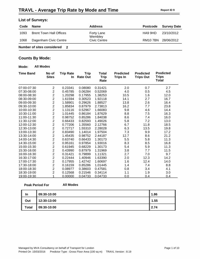
Name Address Postcode Survey DateList of Surveys:Code
Brent Town Hall Offices HA9 9HD 23/10/2012Forty LaneWembley
1093Dagenham Civic Centre RM10 7BN 28/06/2012Civic Centre1068
2Number of sites considered
Counts By Mode:
Report ID 9
Time Band No ofSites
Trip RateIn
TripRate Out
Mode: All ModesTotalTripRate
PredictedTrips In
PredictedTrips Out
PredictedTripsTotal
07:00-07:30 0.080800.233412 0.31421 2.72.0 0.707:30-08:00 0.062840.457852 0.52069 4.54.0 0.508:00-08:30 0.179551.202982 1.38253 12.010.5 1.608:30-09:00 0.305231.615942 1.92118 16.714.1 2.709:00-09:30 0.296261.589012 1.88527 16.413.8 2.609:30-10:00 0.879791.858342 2.73813 23.816.2 7.710:00-10:30 0.529671.131162 1.66083 14.49.8 4.610:30-11:00 0.861841.014452 1.87629 16.38.8 7.511:00-11:30 0.852860.987522 1.84038 16.08.6 7.411:30-12:00 0.825930.664332 1.49026 13.05.8 7.212:00-12:30 1.355600.772062 2.12766 18.56.7 11.812:30-13:00 1.553100.727172 2.28028 19.86.3 13.513:00-13:30 1.140140.834902 1.97504 17.27.3 9.913:30-14:00 0.987521.454352 2.44187 21.212.7 8.614:00-14:30 0.664330.637402 1.30173 11.35.5 5.814:30-15:00 0.978540.951612 1.93016 16.88.3 8.515:00-15:30 0.682290.619452 1.30173 11.35.4 5.915:30-16:00 0.879790.439902 1.31969 11.53.8 7.716:00-16:30 0.798990.314212 1.11321 9.72.7 7.016:30-17:00 1.409460.224442 1.63390 14.22.0 12.317:00-17:30 1.427420.179552 1.60697 14.01.6 12.417:30-18:00 0.852860.161592 1.01445 8.81.4 7.418:00-18:30 0.386030.089772 0.47581 4.10.8 3.418:30-19:00 0.215460.125682 0.34114 3.01.1 1.919:00-19:30 0.047330.000001 0.04733 0.40.0 0.4
2.74
Peak Period For All Modes
InOutTotal
12:30-13:0009:30-10:00 1.86
1.5509:30-10:00
Printed OnManaged by MVA Consultancy on behalf of Transport for London Page 1 of 10
15/03/2016 Predictor Type : Gross Floor Area (100 sq m) TRAVL Version : 8.19

TRAVL - Site Report Report ID 1
Survey Hours 2Survey Hours 1 07:00-22:00Survey Date 19/04/2005
Site Area (sq.m) 402
Class C3 - ResidentialLocation Central
Borough LAMBETHPostcode SW11 4AL
District Battersea
AddressBusiness Residential DevelopmentName Albion Wharf (Affordable)
Gross Floor Area (sq.m) 1950Retail Floor Area (sq.m) 0
PTAL 4
Survey Code 4176 Hester Road,
Construction Phase Employees 0
Num Dwellings1 beds
222 beds
233 beds 4 beds +0 Beds
Residential Units 45 % Car ownership 42Distance To School 338 Distance To Shops 161
Home Work ElseHomeWorkElse
0 0 00 0 00 0 0
Travel Plan No
Survey NoteAn enumerator counted outside the pedestrian/cycle access to the apartment block between 0700 and1900 hours.Self completion residential travel diaries were distributed to residents/visitors in the post a few daysbefore the survey day and were collected on the survey day between 1700 and 2100 hours.
FacilitiesExceptional Circumstances
Site NotesAlbion Wharf is a 5-storey residential block consisting of 45 apartments with shops on the ground floor. Itis set within a residential and commercial area, south of the River Thames adjacent to Battersea Bridge.The apartment is affordable in comparison to the surrounding residential blocks.There is an underground car park, although this is not solely for use by the residents. Commercialbusinesses in the area use the car park more often than residents.All residents own their apartments, nobody we interviewed stated that they rented.
Owner Code Local CouncilDisabled Access No
Total0
Disabled0Parking
Visitor Employee0 0 0
Coaches Load Bays0
Managed Parking Y Waiting Restriction C
Printed OnManaged by MVA Consultancy on behalf of Transport for London Page 1 of 5
14/03/2016 Predictor Type : No of Dwellings TRAVL Version : 8.19
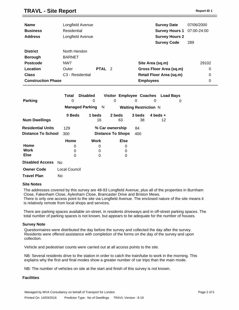
TRAVL - Site Report Report ID 1
Survey Hours 2Survey Hours 1 07:00-24:00Survey Date 07/06/2000
Site Area (sq.m) 29102
Class C3 - ResidentialLocation Outer
Borough BARNETPostcode NW7
District North Hendon
AddressBusiness ResidentialName Longfield Avenue
Gross Floor Area (sq.m) 0Retail Floor Area (sq.m) 0
PTAL 2
Survey Code 289Longfield Avenue
Construction Phase Employees 0
Num Dwellings1 beds
162 beds
633 beds
384 beds +
120 Beds
Residential Units 129 % Car ownership 84Distance To School 300 Distance To Shops 400
Home Work ElseHomeWorkElse
0 0 00 0 00 0 0
Travel Plan No
Survey NoteQuestionnaires were distributed the day before the survey and collected the day after the survey.Residents were offered assistance with completion of the forms on the day of the survey and uponcollection.Vehicle and pedestrian counts were carried out at all access points to the site.NB: Several residents drive to the station in order to catch the train/tube to work in the morning. Thisexplains why the first and final modes show a greater number of car trips than the main mode.NB: The number of vehicles on site at the start and finish of this survey is not known.
Facilities
Site NotesThe addresses covered by this survey are 48-93 Longfield Avenue, plus all of the properties in BurnhamClose, Fakenham Close, Aylesham Close, Brancaster Drive and Briston Mews.There is only one access point to the site via Longfield Avenue. The enclosed nature of the site means itis relatively remote from local shops and services.There are parking spaces available on-street, in residents driveways and in off-street parking spaces. Thetotal number of parking spaces is not known, but appears to be adequate for the number of houses.
Owner Code Local CouncilDisabled Access No
Total0
Disabled0Parking
Visitor Employee0 0 0
Coaches Load Bays0
Managed Parking N Waiting Restriction N
Printed OnManaged by MVA Consultancy on behalf of Transport for London Page 2 of 5
14/03/2016 Predictor Type : No of Dwellings TRAVL Version : 8.19
TRAVL - Site Report Report ID 1
Survey Hours 2Survey Hours 1 07:00-24:00Survey Date 07/06/2000
Site Area (sq.m) 29102
Class C3 - ResidentialLocation Outer
Borough BARNETPostcode NW7
District North Hendon
AddressBusiness ResidentialName Longfield Avenue
Gross Floor Area (sq.m) 0Retail Floor Area (sq.m) 0
PTAL 2
Survey Code 289Longfield Avenue
Construction Phase Employees 0
Exceptional Circumstances
Printed OnManaged by MVA Consultancy on behalf of Transport for London Page 3 of 5
14/03/2016 Predictor Type : No of Dwellings TRAVL Version : 8.19

TRAVL - Site Report Report ID 1
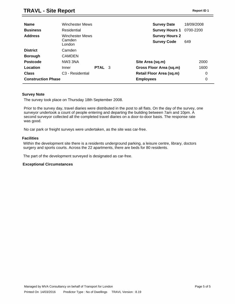
Survey Hours 2Survey Hours 1 0700-2200Survey Date 18/09/2008
Site Area (sq.m) 2000
Class C3 - ResidentialLocation Inner
Borough CAMDENPostcode NW3 3NA
District Camden
AddressBusiness ResidentialName Winchester Mews
Gross Floor Area (sq.m) 1600Retail Floor Area (sq.m) 0
PTAL 3
Survey Code 649Winchester MewsCamdenLondon
Construction Phase Employees 0
Num Dwellings1 beds
02 beds
03 beds
154 beds +
150 Beds
Residential Units 22 % Car ownership 0Distance To School Distance To Shops
Home Work ElseHomeWorkElse
0 0 00 3 00 1 6
Travel Plan YesSite NotesThe site is part of the Visage and Swiss Cottage Cultural Centre(http://www.cabe.org.uk/default.aspx?contentitemid=2047) and is part of a development comprising ofaffordable and non-affordable apartments, a leisure centre with swimming pool, library, doctors surgeryand cafe.There is an underground car park but this particular site is designated as car-free.There are 22 flats in the development of affordable, rented housing managed by Dominion HousingGroup. There are 16 flats on one floor which is known as a 'street in the sky' with open walkways andinternal courtyards, and a further 8 eastern facing duplex apartments. Approximately 10 of these are2-bedroom apartments and 12 are 3-bedroom apartments.The site is within a 2 minute walk from Swiss Cottage tube station and bus stops.
Owner Code PrivateDisabled Access Unknown
Total0
Disabled0Parking
Visitor Employee0 0 0
Coaches Load Bays0
Managed Parking N Waiting Restriction U
Printed OnManaged by MVA Consultancy on behalf of Transport for London Page 4 of 5
14/03/2016 Predictor Type : No of Dwellings TRAVL Version : 8.19
TRAVL - Site Report Report ID 1
Survey Hours 2Survey Hours 1 0700-2200Survey Date 18/09/2008
Site Area (sq.m) 2000
Class C3 - ResidentialLocation Inner
Borough CAMDENPostcode NW3 3NA
District Camden
AddressBusiness ResidentialName Winchester Mews
Gross Floor Area (sq.m) 1600Retail Floor Area (sq.m) 0
PTAL 3
Survey Code 649Winchester MewsCamdenLondon
Construction Phase Employees 0
Survey NoteThe survey took place on Thursday 18th September 2008.Prior to the survey day, travel diaries were distributed in the post to all flats. On the day of the survey, onesurveyor undertook a count of people entering and departing the building between 7am and 10pm. Asecond surveyor collected all the completed travel diaries on a door-to-door basis. The response ratewas good.No car park or freight surveys were undertaken, as the site was car-free.
FacilitiesWithin the development site there is a residents underground parking, a leisure centre, library, doctorssurgery and sports courts. Across the 22 apartments, there are beds for 80 residents.The part of the development surveyed is designated as car-free.Exceptional Circumstances
Printed OnManaged by MVA Consultancy on behalf of Transport for London Page 5 of 5
14/03/2016 Predictor Type : No of Dwellings TRAVL Version : 8.19

TRAVL - Average Trip Rate by Mode and Time
Name Address Postcode Survey DateList of Surveys:Code
Albion Wharf (Affordable) SW11 4AL 19/04/20056 Hester Road,417Longfield Avenue NW7 07/06/2000Longfield Avenue289Winchester Mews NW3 3NA 18/09/2008Winchester Mews
CamdenLondon
649
3Number of sites considered
Counts By Mode:
Report ID 9
Time Band No ofSites
Trip RateIn
TripRate Out
Mode: All ModesTotalTripRate
PredictedTrips In
PredictedTrips Out
PredictedTripsTotal
07:00-07:30 0.076530.086733 0.16327 8.24.3 3.807:30-08:00 0.301020.102043 0.40306 20.25.1 15.108:00-08:30 0.352040.112243 0.46429 23.25.6 17.608:30-09:00 0.295920.127553 0.42347 21.26.4 14.809:00-09:30 0.137760.153063 0.29082 14.57.7 6.909:30-10:00 0.086730.086733 0.17347 8.74.3 4.310:00-10:30 0.102040.051023 0.15306 7.72.6 5.110:30-11:00 0.030610.035713 0.06633 3.31.8 1.511:00-11:30 0.096940.071433 0.16837 8.43.6 4.811:30-12:00 0.040820.035713 0.07653 3.81.8 2.012:00-12:30 0.142860.081633 0.22449 11.24.1 7.112:30-13:00 0.056120.086733 0.14286 7.14.3 2.813:00-13:30 0.061220.096943 0.15816 7.94.8 3.113:30-14:00 0.081630.061223 0.14286 7.13.1 4.114:00-14:30 0.076530.045923 0.12245 6.12.3 3.814:30-15:00 0.051020.071433 0.12245 6.13.6 2.615:00-15:30 0.091840.081633 0.17347 8.74.1 4.615:30-16:00 0.076530.234693 0.31122 15.611.7 3.816:00-16:30 0.086730.127553 0.21429 10.76.4 4.316:30-17:00 0.132650.168373 0.30102 15.18.4 6.617:00-17:30 0.102040.168373 0.27041 13.58.4 5.117:30-18:00 0.219390.244903 0.46429 23.212.2 11.018:00-18:30 0.153060.255103 0.40816 20.412.8 7.718:30-19:00 0.198980.163273 0.36224 18.18.2 9.919:00-19:30 0.183670.285713 0.46939 23.514.3 9.219:30-20:00 0.214290.239803 0.45408 22.712.0 10.720:00-20:30 0.127550.178573 0.30612 15.38.9 6.420:30-21:00 0.122450.137763 0.26020 13.06.9 6.121:00-21:30 0.045920.066333 0.11224 5.63.3 2.321:30-22:00 0.045920.081633 0.12755 6.44.1 2.322:00-22:30 0.054260.077521 0.13178 6.63.9 2.722:30-23:00 0.069770.155041 0.22481 11.27.8 3.523:00-23:30 0.031010.124031 0.15504 7.86.2 1.623:30-24:00 0.100780.077521 0.17829 8.93.9 5.0
Printed OnManaged by MVA Consultancy on behalf of Transport for London Page 1 of 14
14/03/2016 Predictor Type : No of Dwellings TRAVL Version : 8.19

Time Band No ofSites
Trip RateIn
TripRate Out
Mode: All ModesTotalTripRate
PredictedTrips In
PredictedTrips Out
PredictedTripsTotal
0.47
Peak Period For All Modes
InOutTotal
08:00-08:3019:00-19:30 0.29
0.3519:00-19:30
Printed OnManaged by MVA Consultancy on behalf of Transport for London Page 2 of 14
14/03/2016 Predictor Type : No of Dwellings TRAVL Version : 8.19