4.5.1 APPLICATION OF WEB 2.0 IN CARTOGRAPHIC EDUC
11
1 Laszlo Zentai is a Professor of the Department of Cartography and Geoinformatics at Eotvos University, Budapest, Hungary; he is also the Vice-dean of the Faculty of Informatics. Mr. Zentai is the chairman of the Commission on Education and Training of ICA (2003-2007). He has managed such large map and atlas production projects like Atlas of leading and 'avoidable' causes of death in countries of Central and Eastern Europe; Administrative Atlas of Hungary, 1914; Multimedia historical CD-ROM of the Hungarian and Finnish History. His papers are dealing with computer cartography, cartographic education, topographic mapping, environmental protection and webcartography. APPLICATION OF WEB 2.0 IN CARTOGRAPHIC EDUCATION: IS IT TIME FOR CARTOGRAPHY 2.0? László Zentai [email protected] Abstract The term web 2.0 was first used in 2004 at a conference where the organizers focused on the new generation web services. Although web is not software and it has no versions everybody understood this term and also understood the real meaning behind it. In the last 30 years, cartography considerable changed and we may think of using a similar term for our science: cartography 2.0. Although web 2.0 is not a clear and easily definable term, we can list new features of the web which has formed this new term. Wiki, blog, RSS, mashup applications, social networking are the key features (and other less notorious ones are still under development) which are not concrete applications, but rather philosophies. Wiki is a type of website that allows the users to easily edit/change some available content, sometimes without the need for registration. This ease of interaction and operation brought to you by CORE View metadata, citation and similar papers at core.ac.uk provided by Repository of the Academy's Library
Transcript of 4.5.1 APPLICATION OF WEB 2.0 IN CARTOGRAPHIC EDUC
1
Laszlo Zentai is a Professor of the Department of Cartography
and Geoinformatics at Eotvos University, Budapest, Hungary;
he is also the Vice-dean of the Faculty of Informatics. Mr.
Zentai is the chairman of the Commission on Education and
Training of ICA (2003-2007). He has managed such large map
and atlas production projects like Atlas of leading and
'avoidable'
causes of death in countries of Central and Eastern Europe; Administrative Atlas of
Hungary, 1914; Multimedia historical CD-ROM of the Hungarian and Finnish History. His
papers are dealing with computer cartography, cartographic education, topographic
mapping, environmental protection and webcartography.
APPLICATION OF WEB 2.0 IN CARTOGRAPHIC
EDUCATION: IS IT TIME FOR CARTOGRAPHY 2.0?
László Zentai
Abstract
The term web 2.0 was first used in 2004 at a conference where the organizers
focused on the new generation web services. Although web is not software and it has no
versions everybody understood this term and also understood the real meaning behind it.
In the last 30 years, cartography considerable changed and we may think of using a
similar term for our science: cartography 2.0.
Although web 2.0 is not a clear and easily definable term, we can list new features
of the web which has formed this new term. Wiki, blog, RSS, mashup applications, social
networking are the key features (and other less notorious ones are still under development)
which are not concrete applications, but rather philosophies.
Wiki is a type of website that allows the users to easily edit/change some available
content, sometimes without the need for registration. This ease of interaction and operation
brought to you by COREView metadata, citation and similar papers at core.ac.uk
provided by Repository of the Academy's Library
2
makes a wiki an effective tool for collaborative authoring. Can we effectively use this new
technique in cartography?
Blogs provide commentary or news on a particular subject, as personal online
diaries; they can be part of a wider network of social media. There are some cartographic
blogs available (operated mostly by younger cartographers) which can give new chances
for collaborative work, so they may help the cartographic education.
One of the most prominent mashup applications is the websites which are
connected to GoogleEarth to use their basemaps/satellite images to add their own
geographically located contents. These applications are also used by non-cartographers to
help them to “make maps”.
Are these new features enough to introduce the new term: cartography 2.0?
3
Web 2.0 in general
The concept of web 2.0 was first used in 2004 at a conference where the organizers
focused on the new generation web services in a conference brainstorming session.
Although web is not software and it has no versions, everybody understood this term and
also understood the real meaning behind it. It is really difficult to formulate the term and
there is still a huge amount of disagreement about just what web 2.0 means, with some
experts characterizing it as a meaningless marketing buzzword, and others accepting it as
the new term.
Web 2.0 is a platform; this is the most common short definition. Web 2.0 is the
second phase of development of the web, including its architecture and its applications.
The companies that succeed in the Web 2.0 era will be those who understand the rules of
this platform, rather than trying to go back to the rules of the PC software era.
Every significant Web 2.0 application to date has been backed by a specialized
database. Database management is a core competency of Web 2.0 companies, so we have
sometimes referred to these applications as “infoware” rather than merely software.
Infoware is the combination of software and information as illustrated by companies such
as Google, Amazon and eBay. They have good software but their dominance is based
mostly on their information and the critical mass of users they have developed.
Although web 2.0 is not a clear and easily definable term, we can list new features
of the web which has formed this new term. Wiki, blog, RSS, mashup applications, social
networking are the key features which are not concrete applications, but rather
philosophies.
The seeds of Web 2.0 were planted in the middle of 90’s when a set of Perl scripts
was released called PHP. Eventually PHP became a language in its own right, and allowed
programmers to create rich web applications.
4
Wiki
Wiki is one of the most classic examples of Web 2.0 (launched in 2001). Wikipedia
started as an on-line encyclopaedia, a complex of online collaborative entities; it is a
network effect of the combined contributions of their users. Co-creation is a keyword of
wikis: users participate in the creation and delivery of the information.
Wiki is a type of web community that allows the users to easily edit/change some
available content, sometimes without the need for registration. This ease of interaction and
operation makes a wiki an effective tool for collaborative authoring, but this openness is
also a danger: the wikis editable by the general public (such as Wikipedia) have been
criticized for their reliability: certain individuals may maliciously introduce false or
misleading content.
We can effectively use this new technique also in cartography. Similar
collaborative education tools were already developed as real (and expensive) applications,
but the web environment, the free and easy access makes it more attractive for younger
generations. The wiki philosophy is well accepted by this (more open-minded) generation.
The project Wikimapia was launched in May 2006 to combine Google Maps with a
wiki system, allowing users to add information to any location on Earth. WikiMapia is a
Google Maps mashup that lets users add sections to any area on Google Maps. The site is
intended to be a Wikipedia-like reference for the plane. A similar website is Placeopedia,
an online gazetteer which integrates Google Maps images and Wikipedia encyclopedia
articles using user-generated content.
These applications are not real cartographic ones (map or satellite image is only the
background), they just let the common users link their own content to Google Earth or
Google Maps, but the implementation of wiki concept is very important for Web 2.0.
5
Blog
Blog is originally a realization of the traditional personal diary, where people would
keep a running account of their personal lives in web environment (the name was
shortened from “web log”); the first early blogs were launched in 1994, but they became
more visible at the end of 90’s. Early blogs were simply manually updated components of
common websites. However, the evolution of tools to facilitate the production and
maintenance of web articles posted in reverse chronological order made the publishing
process feasible to a much larger, less technical, population.
Blogs became well-known because famous people have also created their own blog
and business blogs have became important marketing tools. Some analysts may overvalue
the importance of business blogs, but these sites should be a part of the business strategy.
Community blogs are more important because they show the real power of blogs: edit
together, free comments, real community space. Nowadays some of the websites were
converted into blogs to make them more interactive, more vivid, to let the users form the
website according to their needs.
Blogs can illustrate very well one of the main concepts of web 2.0: the
decentralization, to make the web bi-directional. Most of the readers of blog spheres are
not only readers, but they also respond to the blog to form the blog sphere itself creating
social networks.
From cartographic point of view we can find interesting blogs (mostly connected to
Google Maps), but there are some interesting blogs on the web which are operated by or
created for cartographers or cartographic communities (http://www.geobloggers.com/;
http://mapperz.blogspot.com/; http://www.maptheuniverse.com/).
6
RSS
RSS (one the most accepted solutions: Really Simple Syndication) is a set of web
feed formats used to publish frequently updated content such as blog entries, news
headlines. An RSS document, which is called a “feed”, or “channel”, contains either a
summary of content from an associated web site or the full text of the original document.
RSS makes it possible for the web users to keep up with their favourite websites in an
automated manner that is easier than checking them time to time manually.
Feed readers are regularly separate software, but web browsers are going to include
these functions in the near future.
RSS feeds have no special cartographic importance but we have to pay attention to
that because their usage may transform the web users’ behaviour.
Mashup applications
A mashup is a website or a special application that combines content dynamically
from more than one source into an integrated site. Most of the mashup applications are
connected to such commercial websites as eBay, Amazon, Flickr, del.icio.us, YouTube and
Google Maps. Google Maps provides the users with on-line maps and satellite images and
they combine their own data with the maps. For whom the creation of mashup application
is too complicated Google released Gooogle MyMaps in 2007, which is a simple online
map creation tool.
Google Maps, Google Earth and similar services like Windows Live Local or
Geoportal influence cartography. In countries where the access of state topography data is
not free or very expensive these services can be good alternatives for non-professional
users. Although it is not easy to define the term web 2.0, but Google Maps is the most
prominent example of web 2.0 applications.
7
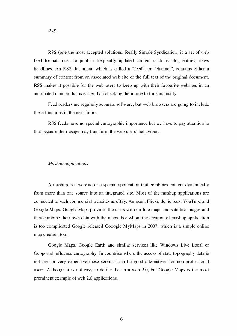
Moscow underground map, an example of Google Maps mashup:
http://kartametro.info/karta/default.aspx?hl=EN
Web 2.0 in cartographic education
The comprehensive summary of Web 2.0 components is not listed in this paper;
some of them do not affect cartography directly. Social networking websites (MySpace,
Facebook, Orkut and their national equivalents) offer an interactive, user-submitted
network of people, personal profiles, blogs, groups, photos, music and videos
internationally. At the moment we cannot really understand the importance and popularity
of these sites, but nowadays they became the most popular websites. Taking this
development into consideration can be useful for cartographers, but cartographers can help
the research of social networks.
8
GIS web environment offers more flexibility and interactions for the users; they
may combine their data with map data offered by the map server. But the map availability
is limited by the map owners and web users cannot add their own map data on-line in this
environment.
The open web standards reacted considerably to the development of web based GIS
both in content and in quality. More and more GIS based mapping service is available on
the web.
The milestone of Web 2.0 cartographic services in Google Maps started in February
2005. For the simple users and for education we have to emphasize the following
advantages:
• Detailed map/satellite image database
• Searching functions
• Simple and intuitive user interface
• Open API (programming interface)
• Free, but reliable service
Building mashups is a task to be the part of the mapmaking in the cartographic
higher education. The students have to have some programming and database management
knowledge, but not much more than what can be expected nowadays from our students. It
can be a very good practice both theoretically and practically to link our existing database
to Google Maps: the project can be very spectacular both for cartography, geography and
GIS students.
Google Maps also may inspire the students to take part in special projects to collect
GPS data in order to create cartographic databases (for example ZIP codes, tourist tracks
etc.) or enrich the existing maps and satellite images. www.openstreetmap.org is a
collaborative space to publish these data according to the „Creative Commons” license.
Such voluntary communities even make the state cartographic services to rethink their data
management policy and business model, hopefully to move to a direction of less strict and
less expensive access to official topographic data. In some countries cartography students
are working on these projects.
9
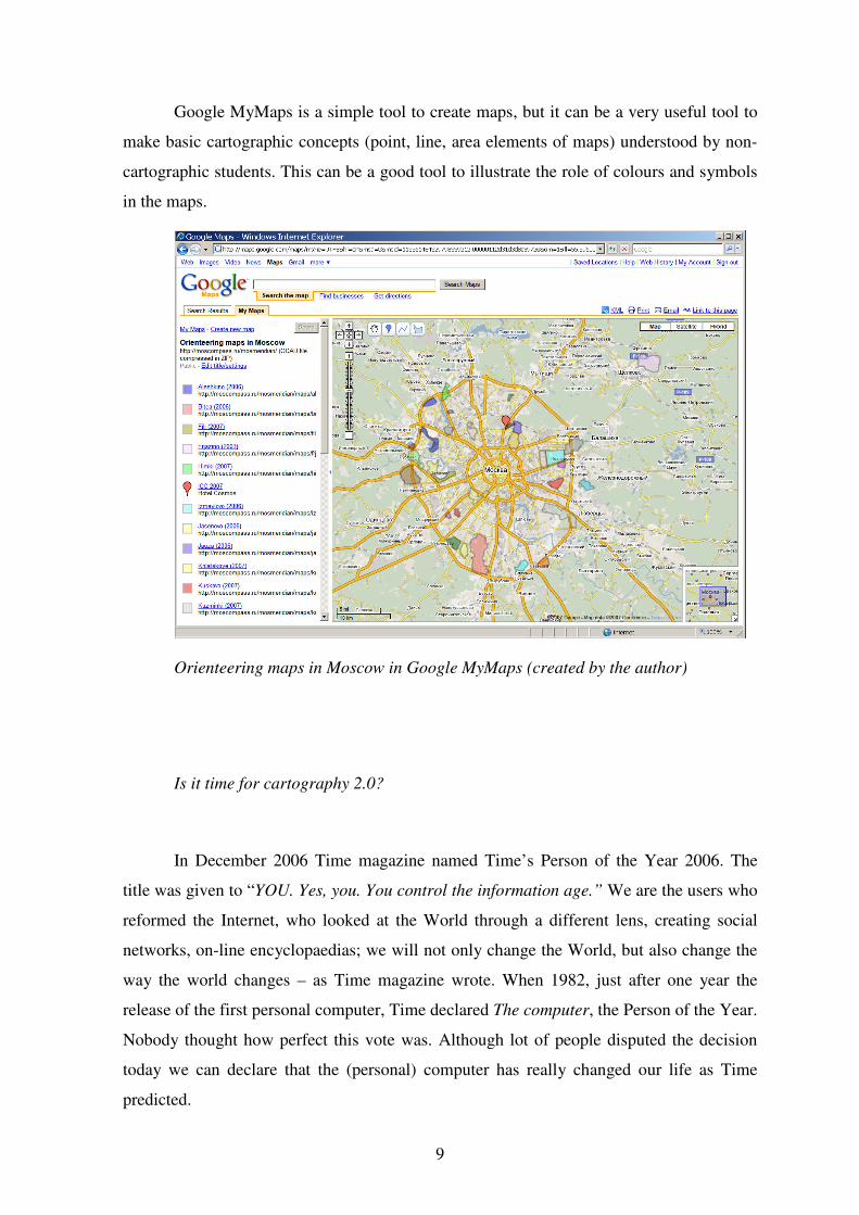
Google MyMaps is a simple tool to create maps, but it can be a very useful tool to
make basic cartographic concepts (point, line, area elements of maps) understood by non-
cartographic students. This can be a good tool to illustrate the role of colours and symbols
in the maps.
Orienteering maps in Moscow in Google MyMaps (created by the author)
Is it time for cartography 2.0?
In December 2006 Time magazine named Time’s Person of the Year 2006. The
title was given to “YOU. Yes, you. You control the information age.” We are the users who
reformed the Internet, who looked at the World through a different lens, creating social
networks, on-line encyclopaedias; we will not only change the World, but also change the
way the world changes – as Time magazine wrote. When 1982, just after one year the
release of the first personal computer, Time declared The computer, the Person of the Year.
Nobody thought how perfect this vote was. Although lot of people disputed the decision
today we can declare that the (personal) computer has really changed our life as Time
predicted.
10
The decision of Time at the end of 2006 practically acknowledged the importance
of Web 2.0, the importance of the term, which was first used only 2 years before.
Web 2.0 is first of all a business and the service providers are looking for more
income, and they are not afraid of using new, easily marketable terms, but the term is
really short, unusual and understandable for everybody.
Understanding the importance of Web 2.0 we can integrate its most important
elements into the cartographic higher education:
• Building mashup applications.
• Blog environments as tools in cartography (map making, map producing,
map updating).
• Using wikis as source of information for mapmaking (reliability vs.
usability).
• On-line cartographic databases.
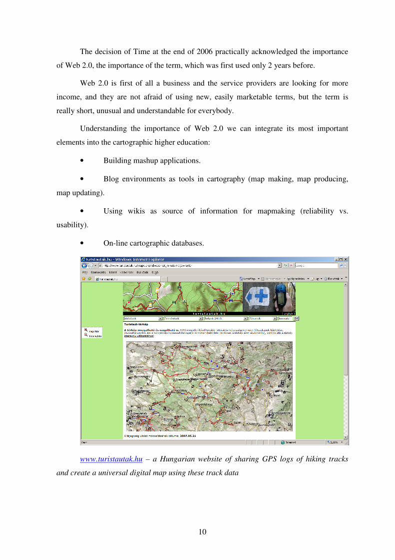
www.turistautak.hu – a Hungarian website of sharing GPS logs of hiking tracks
and create a universal digital map using these track data
11
Is it much enough to use the term cartography 2.0? Can we use this analogy for
cartography?
This term would be as unusual, but easily understandable as the term Web 2.0. We,
cartographers, can probably benefit by using this term to get more interest from the media
and business. We can list advances of the contemporary cartography to support this term,
although the changes were not as fast and evident as in the case of Web 2.0. However,
taking into account and comparing the some hundred years old tradition of cartography and
the revolutionary changes of the last 30-40 years (remote sensing, GIS, computer
cartography, GPS) we can adopt the new term.
In higher education using this new term can be as attractive and “profitable” as the
GIS was in the last ten years. But we have to emphasize that the long term tradition of
cartography is included in the new term: cartography 2.0 is not simply GIS, it is the
cartography of the 21st century.
References:
CAMPBELL, S.-FOUCHÉ, S.-WEISS, K.: Cartography on Social Networks.
http://www.wam.umd.edu/~susanc/blogscape/BlogScape2.pdf
O’REILLY, T.: What is Web 2.0.
http://www.oreillynet.com/pub/a/oreilly/tim/news/2005/09/30/what-is-web-
20.html, 09/30/2005
ZENTAI, L.-GUSZLEV, A.: Web2 és térképészet. Geodézia és Kartográfia, 2006/11.,
16-23. p.