41st Avenue B-Line - Vancouver
12
For more information visit: vancouver.ca/41stbline February 2019 1. WELCOME! 41st Avenue B-Line Kerrisdale Village Street Improvements Public Open House Please sign in so we can provide updates and information on construction 1. Talk to City and TransLink staff or the project team. 2. Fill out a comment sheet here, or later, online at: vancouver.ca/41stbline 3. Write us at: [email protected] 4. Call us at 3-1-1 HOW CAN YOU PROVIDE INPUT? THE NEW B-LINE WILL FEATURE THE FOLLOWING ELEMENTS: • Improved travel time and reliability – stops spaced approximately 1 km apart, new articulated buses, all-door boarding. • Frequent service – bus service would be every 3-6 minutes in peak times and every 8-10 minutes during non-peak. • Available all day – service hours would be between 6am - 1am. • Bus stop amenities – stops will have digital signage showing arrival times, and route information inside buses. The City of Vancouver is working with TransLink to introduce a new B-Line bus service along the 41st Avenue corridor as part of the Mayors’ 10-Year Vision. The proposed service changes include replacing Bus Route 43 with the new B-Line bus service and modifying the existing Bus Routes 41 and 49 as a result of the introduction of the new B-Line.
Transcript of 41st Avenue B-Line - Vancouver

For more information visit: vancouver.ca/41stblineFebruary 2019
1. WELCOME!
41st Avenue B-Line Kerrisdale Village Street Improvements
Public Open HousePlease sign in so we can provide updates and information on construction
1. Talk to City and TransLink staffor the project team.
2. Fill out a comment sheet here,or later, online at: vancouver.ca/41stbline
3. Write us at: [email protected]
4. Call us at 3-1-1
HOW CAN YOU PROVIDE INPUT?
THE NEW B-LINE WILL FEATURE THE FOLLOWING ELEMENTS:
• Improved travel time and reliability– stops spaced approximately 1 km apart,new articulated buses, all-door boarding.
• Frequent service – bus service would be every3-6 minutes in peak times and every 8-10minutes during non-peak.
• Available all day – service hours would bebetween 6am - 1am.
• Bus stop amenities – stops will have digital signage showingarrival times, and route information inside buses.
The City of Vancouver is working with TransLink to introduce a new B-Line bus service along the 41st Avenue corridor as part of the Mayors’ 10-Year Vision. The proposed service changes include replacing Bus Route 43 with the new B-Line bus service and modifying the existing Bus Routes 41 and 49 as a result of the introduction of the new B-Line.
For more information visit: vancouver.ca/41stblineFebruary 2019
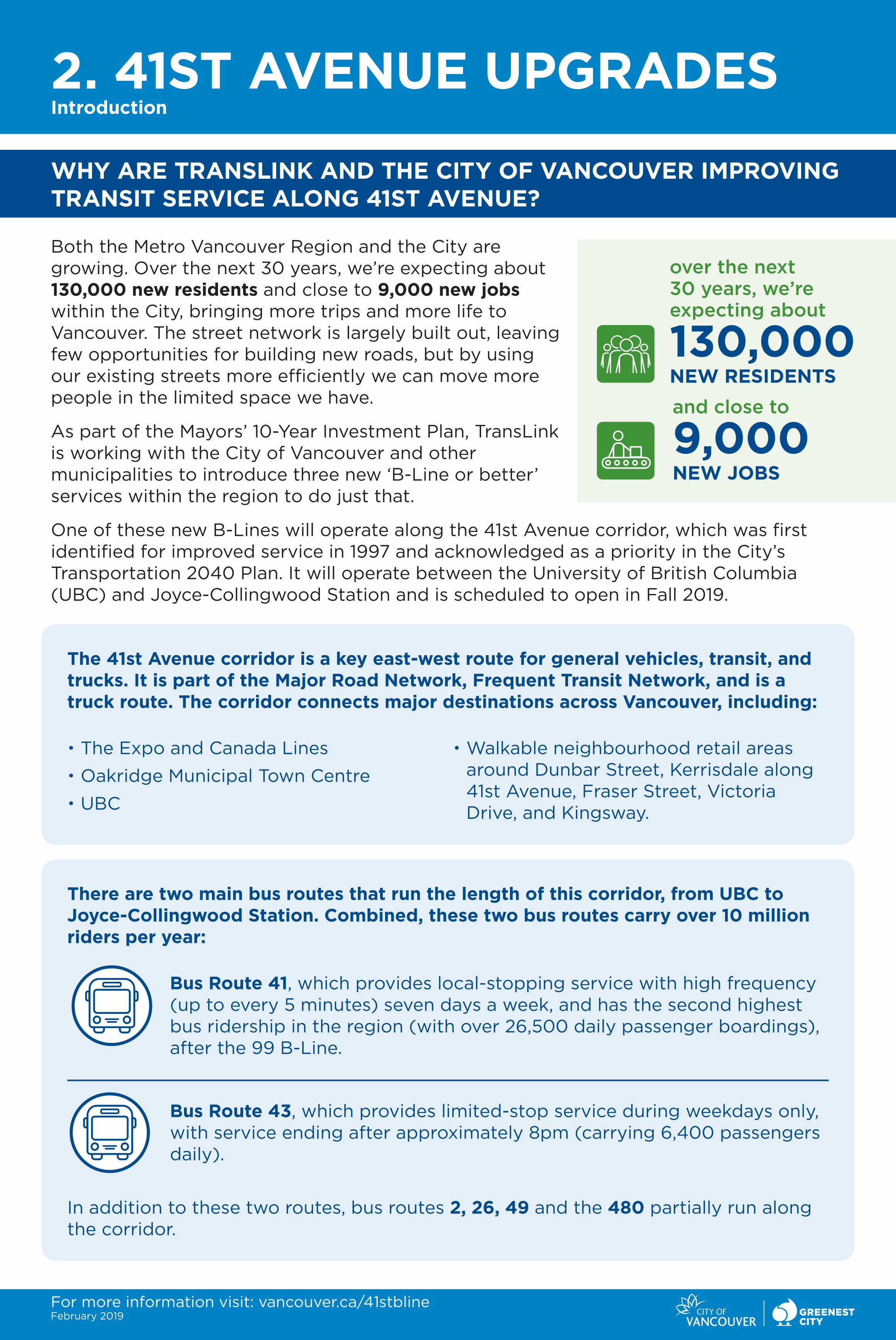
2. 41ST AVENUE UPGRADESIntroduction
WHY ARE TRANSLINK AND THE CITY OF VANCOUVER IMPROVING TRANSIT SERVICE ALONG 41ST AVENUE?
Both the Metro Vancouver Region and the City are growing. Over the next 30 years, we’re expecting about 130,000 new residents and close to 9,000 new jobs within the City, bringing more trips and more life to Vancouver. The street network is largely built out, leaving few opportunities for building new roads, but by using our existing streets more efficiently we can move more people in the limited space we have.
As part of the Mayors’ 10-Year Investment Plan, TransLink is working with the City of Vancouver and other municipalities to introduce three new ‘B-Line or better’ services within the region to do just that.
One of these new B-Lines will operate along the 41st Avenue corridor, which was first identified for improved service in 1997 and acknowledged as a priority in the City’s Transportation 2040 Plan. It will operate between the University of British Columbia (UBC) and Joyce-Collingwood Station and is scheduled to open in Fall 2019.
over the next 30 years, we’re expecting about
130,000NEW RESIDENTS
and close to
9,000NEW JOBS
There are two main bus routes that run the length of this corridor, from UBC to Joyce-Collingwood Station. Combined, these two bus routes carry over 10 million riders per year:
Bus Route 41, which provides local-stopping service with high frequency (up to every 5 minutes) seven days a week, and has the second highest bus ridership in the region (with over 26,500 daily passenger boardings), after the 99 B-Line.
Bus Route 43, which provides limited-stop service during weekdays only, with service ending after approximately 8pm (carrying 6,400 passengers daily).
In addition to these two routes, bus routes 2, 26, 49 and the 480 partially run along the corridor.
The 41st Avenue corridor is a key east-west route for general vehicles, transit, and trucks. It is part of the Major Road Network, Frequent Transit Network, and is a truck route. The corridor connects major destinations across Vancouver, including:
• The Expo and Canada Lines
• Oakridge Municipal Town Centre
• UBC
• Walkable neighbourhood retail areas around Dunbar Street, Kerrisdale along 41st Avenue, Fraser Street, Victoria Drive, and Kingsway.

For more information visit: vancouver.ca/41stblineFebruary 2019
3. 41ST AVENUE UPGRADES Introduction continued
The majority of respondents supported the proposed 41st Avenue B-Line stop locations, changes to local routes and transit priority measures.
A large majority of transit users supported changes to streets and intersections to support speed and reliability of the new 41st Avenue B-Line. Support was strong across all proposed transit priority measures.
Being a busy vehicle and transit corridor, Bus Routes 41 and 43 have the following characteristics when averaged over the year. During peak times, the conditions are likely worse.
Transit Ridership within the City and Region
Transit ridership continues to increase within Metro Vancouver and the City. Vancouver has one of the busiest transit systems in North America and transit is often at capacity. To the right is an image of historic ridership trends in the region.
Did you know?During peak times, transit carries
40-60% of people travelling on 41st Avenue between Dunbar and Granville
WHAT CONSULTATION HAS BEEN DONE TO DATE?
In Spring 2018, TransLink consulted transit passengers and neighborhoods along the proposed new B-Line corridors to solicit feedback on proposed bus stops, local service changes and speed/reliability measures. A total of 2,368 completed survey responses on the 41st Avenue B-Line were received.
The level of public support for all aspects of the B-Line proposal was highly positive:
Since Fall 2018, the City has also been consulting with key stakeholders including business improvement associations, schools, and community centres to gather feedback and to develop a better understanding of the local issues that might influence the project.
Bus Speed Overcrowding Bunching
Bus 41 21km/h 17% 8%
Bus 43 24km/h 11% 3%

For more information visit: vancouver.ca/41stblineFebruary 2019
4. 41ST AVENUE UPGRADES Policy Background
OTHER RELATED POLICIES
Arbutus Greenway Design Vision and Implementation Strategy (2018):
Identified and proposed a broad range of public realm and active transportation improvements along the Arbutus corridor, including fully segregated walking and cycling pathways, public gathering areas, site furniture and other public amenities.
Congestion Management Strategy (2017):
Provides direction on identifying and monitoring impacts to traffic flow on the street network, developing strategies to address impacted areas of congestion, and tracking progress and results. It also builds on T2040 policies and emerging directions in the TransLink 10-Year Investment Plan.
2014 Mayor’s Council developed the 10-Year Vision
2017 - 2018 TransLink consulted with the public on the new B-Line corridors
2018City continued consultation on street improvements with stakeholders and general public
Early 2019 WE ARE HERE
Public Open House – Kerrisdale District
Spring 2019 Refining and reporting out on design changes
Summer / Fall 2019Anticipated implementation of most measures along the corridor and launch of B-Line
2020 Implementation of additional measures
WHERE ARE WE IN THE PROCESS?
TARGET:• Make two-thirds of trips on foot, bike
or transit by 2040
• Reduce the average distance driven per resident by 20% (from 2007 levels).
TRANSIT VISION: • Support transit improvements to
increase capacity and ensure service that is fast, frequent, reliable, fully accessible, and comfortable.
POLICIES: • Collaborate with TransLink to provide
fast, frequent, high-capacity, and fully accessible transit service on high-demand corridors including Broadway, Hastings, 41st/49th Avenue, Commercial/Victoria, and Main/Fraser.
• Work with TransLink and the Province to improve the frequency, capacity, reliability, and service span of local transit, prioritizing high-demand corridors.
TRANSPORTATION 2040
Transportation 2040 is a long-term strategic vision for the City that helps guide transportation and land use decisions and public investments.

New
B-L
ines
in 2
019
van
co
uve
r
ric
hm
on
d
del
ta
su
rr
ey
wh
ite
ro
ck
lan
gle
y
map
ler
idg
ep
itt
mea
do
ws
po
rt
co
qu
itla
mb
ur
nab
y new
wes
tmin
ste
rbel
car
ra
anm
or
e
do
wn
tow
np
or
tm
oo
dy
no
rth
van
co
uve
r
wes
tva
nc
ou
ver
co
qu
itla
m
Lege
nd
Cana
da L
ine
Expo
Lin
eM
illen
nium
Lin
e
Exis
ting
95,
96,
99
B-Li
nes
New
B-L
ines
in 2
019
Wes
t Coa
st E
xpre
ssSe
aBus
Loug
heed
Hw
y
41st
Ave
nue
Mar
ine–
Mai
n

dR yradnuoB
tS enyT
East Mall
Wesbrook Mall
Agro
nom
y Rd
tS eibmaCtS eibmaC
tS niaM
tS resarF
tS thginK
rD airotciV
tS nodneralC
evA nosrettaP
trepuRtS
Joyce St
tS kaO
tS ellivnarG
Dunbar St
Crown St
W 1
6th
Ave
Mackenzie St
Carnarvon St
West Blvd
SW M
arin
e Dr
SW Marine Dr
tS rreK
King
sway
Blenheim St
W 4
9th
Ave
W 3
3rd
Ave
E 33
rd A
ve
E 49
th A
ve
E 41
st A
veW
41s
t Ave
B-L
ine
eniL adanaC
Mill
enni
um L
ine
Expo
Line
Joyc
e–Co
lling
woo
d
Dun
bar L
oop
Oak
ridg
e–
Lang
ara–
Met
roto
wn
UB
C Ex
chan
ge
Ce
ntr
al
Pa
rk
Pa
rk
Qu
ee
nEl
iza
be
thP
ark
Fra
ser
Riv
er
Pa
rk
Plan
ned
netw
ork
Joyc
e–Co
lling
woo
d
King
sway
Rupe
rtSt
reet
Clar
endo
nSt
reet
Vict
oria
Dri
ve
Knig
htSt
reet
Fras
erSt
reet
Mai
nSt
reet
Oak
ridg
e–G
ranv
ille
Stre
et
Oak
Stre
etW
est
Boul
evar
d
Carn
arvo
nSt
reet
Dun
bar
Loop
Aven
ue
Agro
nom
yRo
ad
UBC
Exch
ange
B-L
ine
Plan
ned
stop
s
Lege
nd
Plan
ned
B-Li
ne ro
ute
Plan
ned
B-Li
ne s
top
Bus
exch
ange
SkyT
rain
sta
tion
Bus
exch
ange
B-L
ine
Futu
re 4
1st A
venu
e B-
Line
and
Cha
nges
to L
ocal
Rou
tes
Ro
ute
43
repl
aced
with
new
B-L
ine
Ro
ute
41
chan
ged
to ru
n be
twee
n
Crow
n St
reet
and
Joyc
e St
atio
n

Lege
nd
0-10
km
/h
10-2
0 km
/h
20-3
0 km
/h
30-4
0 km
/h
40-5
0 km
/h
50+
km/h

For more information visit: vancouver.ca/41stblineFebruary 2019
8. 41ST AVENUE UPGRADES Transportation Improvements and Evaluation
WHAT DECISION MAKING GOES INTO TRANSPORTATION IMPROVEMENTS AND AMENITIES? HOW DO CITIES DECIDE WHAT CHANGES TO MAKE?
Enhancements to a B-Line service, or any transit services, are dependent on municipal collaboration with TransLink. These decisions are made through rigorous analysis, traffic studies and modeling of the street network to ensure overall traffic performance is improved and bus travel times are reduced.
To evaluate the effectiveness of potential transportation improvements and amenities, City staff undertake a monitoring and evaluation framework that includes but is not limited to the following:
Safety Parking Needs
Accessibility Loading Needs
Connectivity to Key destinations
Volumes and Delay for All Modes
BUS STOP AMENITIES
When funding is available, the addition of bus stops with amenities such as shelters, benches and real-time displays improves the waiting environment at bus stops. Adding amenities also results in greater rider satisfaction, and higher ridership.

For more information visit: vancouver.ca/41stblineFebruary 2019
9. 41ST AVENUE UPGRADESTransit Benefits – Improved People Moving Capacity
HOW WILL YOU BENEFIT FROM IMPROVED SERVICE ALONG 41ST AVENUE?
People using transit can:
» Save time through faster, more frequent and more reliable service
» Have improved access to employment opportunities, educational and health institutions, community centres and libraries.
» Have higher levels of productivity by using time spent on public transit to carry out other tasks.
» Save money - compared to driving, traveling by transit is much more affordable.
» Experience less stress by avoiding having to drive in highly congested areas and find parking.
» Have greater mobility, especially for those who don’t or can’t drive, which facilitates greater access to employment, social services and social interaction with friends and family.
Residents, businesses, and communities:
» By carrying more passengers by bus, which takes up less road space than individual cars, it keeps traffic moving and reduces air pollution from idling vehicles.
» More frequent and reliable transit services will bring more people to retail areas and make communities more vibrant and lively.
» Money spent on public transportation has a high economic return in comparison to private automobile and housing prices.
HOW DO WE DETERMINE THESE BENEFITS?
On an annual basis, TransLink measures the performance of all transit services, including the number of boardings, transit vehicle speeds, on-time performance of buses, etc. They also conduct customer service performance surveys every 3 months. Together, these reports will provide TransLink and the City with an understanding of how well the B-Line service is performing and meeting the needs of transit users.
The environmental, community, and economic impacts of the new B-Line will be more difficult to determine, as there are many other factors at play. The City will continue to monitor the new B-Line service after it launches and identify if additional changes are required to further improve the corridor’s people-moving capacity and/or to better capture the community benefits of the service.

For more information visit: vancouver.ca/41stblineFebruary 2019
B-Line Project
• The changes shown in board #11 are being proposed as part of the B-Line project.
Arbutus Greenway
• Narrowing East Boulevard north of 41st Avenue means that the space gained can be reserved to be a future programmable public space, as identified during the Arbutus Greenway design process. At the moment, Kerrisdale Village does not have a public space that can be used for programmed events and activities like many other BIA areas across the city.
Additional Potential Future Changes
• There is the potential in the future to add a new vehicular crossing at 39th Avenue and at 42nd Avenue along West Boulevard to improve local circulation.
As a result, westbound vehicles often block the greenway crossing, making it challenging for people walking and riding bicycles to cross north-south. This is particularly challenging for people using mobility aids like wheelchairs, and for those with visual impairments.
10. 41ST AVENUE UPGRADESTransportation Design Process
What We HeardThe City heard historically and through the Arbutus Greenway consultation and discussions with businesses in the area that crossing at the West and East Boulevard intersections could be made easier for people on foot or bike.
Currently many of the vehicle movements are hard to make and vehicles, including buses, are often trapped in the small queue space between the two boulevards.
We are also interested in hearing your
thoughts about this
idea.
Bike Path
Pedestrian Path
Public Plaza
Architectural Structures supporting Lighting, and Opportunities for Future Public Art
Coffee Kiosk
Accessible Public Washroom
Shade Trees With Movable Chairs
Green Infrastructure/ Raingarden
West
Bo
ule
vard
W 41st Ave
East
Bo
ule
vard
Character Zone 5 PLAN VIEWS
PRE-STREETCAR PLAN VIEW
23ARBUTUS GREENWAY DESIGN VISION 42ND AVENUE
39TH AVENUE
41ST AVENUE
DR
AV
ELU
OB
TSA
E
DR
AV
ELU
OB
TSE
W
What We’re ProposingThe City worked with TransLink to investigate improvements to make the area safer for people walking, cycling and rolling and to improve the flow and reliability of buses and general purpose vehicles along 41st Avenue.
Arbutus Greenway Design Vision

Fo
r m
ore
in
form
ati
on
vis
it: van
co
uver.ca/4
1stb
line
Feb
ruary
20
19
11. 4
1ST
AV
EN
UE
UP
GR
AD
ES
Re
co
mm
en
de
d T
ran
spo
rtati
on
De
sig
n
N
YA WNEERG SUTUBRA
41S
T A
VE
NU
E
LA
NE
WA
Y
DRAVELUOB TSAE
DRAVELUOB TSE W
TEERTS ELPAM
A
K
BC
D
G
E
HJ
C
CF
I
IJ
Wh
at
is D
iffe
ren
t?W
hy?
Intr
od
uce a
n e
ast
bo
un
d left
-tu
rn b
ay
To im
pro
ve t
raff
ic f
low
an
d r
ed
uce s
ho
rt-c
utt
ing
th
rou
gh
n
earb
y lo
cal st
reets
. It
sh
ou
ld a
lso
red
uce c
han
ces
for
co
nfl
icts
wit
h p
ed
est
rian
s.
Rem
ove 1
-3 p
ark
ing
sta
lls a
nd
re
locate
lo
ad
ing
zo
ne
To m
ake s
pace f
or
a n
ew
east
bo
un
d left
-tu
rn lan
e o
n 4
1st
Aven
ue. M
ore
sh
ort
-term
park
ing
can
be p
rovid
ed
in
th
e
nearb
y E
asy
Park
lo
t o
n E
ast
Bo
ule
vard
if
necess
ary
.
Exp
lore
op
po
rtu
nit
ies
to f
ix a
nd
re
pair
cro
ssw
alk
sTo
red
uce t
rip
pin
g h
azard
s fo
r p
ed
est
rian
s, p
art
icu
larl
y
tho
se w
ith
mo
bili
ty d
evic
es
an
d s
tro
llers
.
Rem
ove t
he t
raff
ic s
ign
al an
d
cro
ssw
alk
at
East
Bo
ule
vard
an
d
pro
vid
e a
cen
traliz
ed
gre
en
way
cro
ssin
g
To m
ake t
he c
ross
ing
of
the g
reen
way s
afe
r fo
r p
eo
ple
w
alk
ing
an
d c
yclin
g b
y r
ed
ucin
g t
he n
ort
h-s
ou
th p
ed
est
rian
cro
ssin
g d
ista
nce a
t E
ast
Bo
ule
vard
an
d r
ed
ucin
g t
he
ch
an
ces
of
co
nfl
ict
at
the c
ross
walk
s w
ith
veh
icle
s tu
rnin
g
left
. H
ow
ever, p
ed
est
rian
s w
alk
ing
to
/fro
m t
he m
ajo
r o
rig
ins/
dest
inati
on
s east
of
East
Bo
ule
vard
will
need
to
w
alk
fu
rth
er
to c
ross
41s
t A
ven
ue.
Reass
ign
th
e e
ast
bo
un
d c
urb
lan
e
to a
rig
ht
turn
lan
e a
nd
a t
ran
sit
lan
e (
fro
m W
est
Bo
ule
vard
to
th
e
east
bo
un
d b
us
sto
p)
To h
elp
pre
ven
t th
rou
gh
-mo
vin
g v
eh
icle
s fr
om
gett
ing
stu
ck
beh
ind
rig
ht-
turn
ing
veh
icle
s w
hic
h im
pro
ves
traff
ic f
low
. T
he t
ran
sit
lan
e h
elp
s b
use
s tr
avel th
rou
gh
th
e a
rea m
ore
re
liab
ly.
Reass
ign
th
e w
est
bo
un
d c
urb
lan
e
to a
rig
ht-
turn
lan
e a
nd
len
gth
en
th
e
exis
tin
g w
est
bo
un
d left
-tu
rn b
ay
To h
elp
pre
ven
t th
rou
gh
-mo
vin
g v
eh
icle
s fr
om
gett
ing
stu
ck
beh
ind
left
- o
r ri
gh
t-tu
rnin
g v
eh
icle
s w
hic
h im
pro
ves
traff
ic
flo
w.
Wh
at
is D
iffe
ren
t?W
hy?
Rest
rict
veh
icle
mo
vem
en
t to
ri
gh
t-in
/rig
ht-
ou
tTo
sim
plif
y t
he in
ters
ecti
on
an
d lead
to
few
er
veh
icle
m
ovem
en
ts. T
his
ch
an
ge a
lso
pre
ven
ts w
est
bo
un
d left
-tu
rnin
g
veh
icle
s w
ho
are
tu
rnin
g o
nto
East
Bo
ule
vard
fro
m b
lockin
g
west
bo
un
d left
-tu
rnin
g v
eh
icle
s w
ho
are
tu
rnin
g o
nto
West
B
ou
levard
.
Rest
rict
veh
icle
mo
vem
en
t to
ri
gh
t-in
on
ly f
rom
41s
t A
ven
ue
an
d c
onvert
East
Bo
ule
vard
to
o
ne-w
ay n
ort
hb
ou
nd
fro
m 4
1st
Aven
ue t
o t
he lan
e n
ort
h o
f 4
1st
Aven
ue
To s
imp
lify t
he in
ters
ecti
on
an
d lead
to
few
er
veh
icle
m
ovem
en
ts, so
me o
f w
hic
h a
re d
iffi
cu
lt in
th
e e
xis
tin
g
co
nd
itio
n. T
hese
ch
an
ges
will
als
o p
reven
t so
uth
bo
un
d v
eh
icle
s o
n E
ast
Bo
ule
vard
, n
ort
h o
f 4
1st
Aven
ue, fr
om
co
nfl
icti
ng
wit
h
west
bo
un
d v
eh
icle
s o
n 4
1st
Aven
ue. A
fu
ture
pro
gra
mm
ab
le
pu
blic
sp
ace a
lso
beco
mes
availa
ble
.
Relo
cate
east
bo
un
d b
us
sto
p t
o
far
sid
e o
f E
ast
Bo
ule
vard
an
d
west
bo
un
d b
us
sto
p t
o n
ear
sid
e
of
East
Bo
ule
vard
Avo
ids
the b
use
s g
ett
ing
stu
ck b
eh
ind
rig
ht-
turn
ing
veh
icle
s an
d v
ice v
ers
a. A
lso
, p
rovid
es
mo
re s
treet
space f
or
wait
ing
tr
an
sit
pass
en
gers
, an
d p
ed
est
rian
s w
alk
ing
by.
Rem
ove 7
-8 p
ark
ing
sta
lls f
rom
th
e n
ort
h s
ide o
f 4
1st
Aven
ue a
nd
8
-9 p
ark
ing
sta
lls f
rom
th
e s
ou
th
sid
e o
f 4
1st
Aven
ue
To m
ake s
pace f
or
the n
ew
bu
s st
op
s. M
ore
sh
ort
-term
park
ing
can
be p
rovid
ed
in
th
e n
earb
y E
asy
Park
lo
t o
n E
ast
Bo
ule
vard
if
necess
ary
.
Tu
rn M
ap
le S
treet
into
a f
ully
si
gn
aliz
ed
in
ters
ecti
on
Up
gra
din
g t
o a
fu
lly s
ign
aliz
ed
in
ters
ecti
on
will
im
pro
ve v
eh
icle
access
to
bu
sin
ess
es
sou
th o
f 4
1st
Aven
ue a
nd
to
th
e lan
e
no
rth
of
41s
t A
ven
ue.
A B C D E F
G H I J K
PR
OP
OS
ED
C
HA
NG
ES

For more information visit: vancouver.ca/41stblineFebruary 2019
12. NEXT STEPS
Talk to City and TransLink staff or the project team.
Fill out a comment sheet here, or later, online at: vancouver.ca/41st-bline. The consultation period for this segment of the route will close on March 1, 2019.
Staff will work with TransLink to refine the East 41st Boulevard changes based on feedback from local businesses, residents and other stakeholders.
Some improvements will be made for Fall 2019 and others will be delivered in 2020.