4.0 Heritage Significance
33
Conservation Management Plan Birchgrove Park Mayne-Wilson & Associates Conservation Landscape Architects 39 4.0 Heritage Significance 4.1 Recognition of the Park as a Heritage Place The preamble to the Burra Charter summarises the value of heritage places to the community, as follows: “places of cultural significance enrich people’s lives, often providing a deep and inspirational sense of connection to community and landscape, to the past and to lived experiences. They are historical records, that are important as tangible expressions of Australian identity and experience. . . . They tell us about who we are and the past that has formed us and the Australian landscape. They are irreplaceable and precious . . . and must be conserved for present and future generations.” 4.2 Purpose and scope of a Statement of Significance In the Burra Charter, cultural significance is defined as follows: Cultural significance means aesthetic, historic, scientific, social or spiritual value for past, present or future generations. Cultural significance is embodied in the place itself, its fabric, setting, use, associations, meanings, records, related places and related objects. Places may have a range of values for different individuals or groups. Understanding significance is crucial to the care of a place of cultural significance. It provides the basis for the development of policy for managing the place, and is reliant upon a thorough understanding of the place itself and what contributes to its significance. A statement of significance is a formal method used to describe the qualities that make a place important to the community as a whole. The preparation of statement of significance is an accepted method, used by professionals and organisations involved with heritage, to convey the importance of a place 12 . A secondary role is to communicate to people unfamiliar with the place’s importance and to promote clear thinking and a framework for action among those responsible for its conservation. 4.3 Statement of Significance The significance of the Park is discussed in relation to the criteria adopted by the NSW Heritage Office and set out in its guidelines document Assessing Heritage Significance 2001. These have been used in the following assessment, and its criteria are set out below: 13 4.3.1 NSW Heritage Office criteria for assessment of significance Criterion (a): importance in the course, or pattern, of NSW's or the local area’s cultural or natural history; Criterion (b): strong or special association with the life or works of a person, or group of persons, of importance in the cultural or natural history of NSW or the local area; Criterion (c): importance in demonstrating aesthetic characteristics and/or a high degree of creative or technical achievement in NSW or the local area; Criterion (d): strong or special association with a particular community or cultural group in NSW or the local area for social, cultural or spiritual reasons; 12 The method for assessing significance is described in detail in Assessing Heritage Significance, NSW Heritage Office 2001. Whilst the wording of criteria is arranged differently from the Burra Charter, the overall intent is to encompass all aspects of significance . 13 NSW Heritage Assessment Criteria, as adopted from April 1999
Transcript of 4.0 Heritage Significance
Conservation Management Plan Birchgrove Park
Mayne-Wilson & Associates Conservation Landscape Architects
39
4.0 Heritage Significance 4.1 Recognition of the Park as a Heritage Place The preamble to the Burra Charter summarises the value of heritage places to the community, as follows:
“places of cultural significance enrich people’s lives, often providing a deep and inspirational sense of connection to community and landscape, to the past and to lived experiences. They are historical records, that are important as tangible expressions of Australian identity and experience. . . . They tell us about who we are and the past that has formed us and the Australian landscape. They are irreplaceable and precious . . . and must be conserved for present and future generations.”
4.2 Purpose and scope of a Statement of Significance In the Burra Charter, cultural significance is defined as follows:
Cultural significance means aesthetic, historic, scientific, social or spiritual value for past, present or future generations. Cultural significance is embodied in the place itself, its fabric, setting, use, associations, meanings, records, related places and related objects. Places may have a range of values for different individuals or groups.
Understanding significance is crucial to the care of a place of cultural significance. It provides the basis for the development of policy for managing the place, and is reliant upon a thorough understanding of the place itself and what contributes to its significance. A statement of significance is a formal method used to describe the qualities that make a place important to the community as a whole. The preparation of statement of significance is an accepted method, used by professionals and organisations involved with heritage, to convey the importance of a place12. A secondary role is to communicate to people unfamiliar with the place’s importance and to promote clear thinking and a framework for action among those responsible for its conservation. 4.3 Statement of Significance The significance of the Park is discussed in relation to the criteria adopted by the NSW Heritage Office and set out in its guidelines document Assessing Heritage Significance 2001. These have been used in the following assessment, and its criteria are set out below:13 4.3.1 NSW Heritage Office criteria for assessment of significance Criterion (a): importance in the course, or pattern, of NSW's or the local area’s cultural or natural
history; Criterion (b): strong or special association with the life or works of a person, or group of persons,
of importance in the cultural or natural history of NSW or the local area; Criterion (c): importance in demonstrating aesthetic characteristics and/or a high degree of
creative or technical achievement in NSW or the local area; Criterion (d): strong or special association with a particular community or cultural group in NSW
or the local area for social, cultural or spiritual reasons;
12 The method for assessing significance is described in detail in Assessing Heritage Significance, NSW Heritage Office 2001. Whilst the wording of criteria is arranged differently from the Burra Charter, the overall intent is to encompass all aspects of significance. 13 NSW Heritage Assessment Criteria, as adopted from April 1999

Conservation Management Plan Birchgrove Park
Mayne-Wilson & Associates Conservation Landscape Architects
40
Criterion (e): potential to yield information that will contribute to an understanding of NSW's or the local area’s cultural or natural history;
Criterion (f): possession of uncommon, rare or endangered aspects of the cultural or natural history of NSW or the local area;
Criterion (g): importance in demonstrating the principal characteristics of a class of NSW’s or the local area’s cultural or natural places or environments.
To be assessed as having heritage significance, an item or place must:
o meet at least one or more of the nature of significance criteria [criteria a, b, c, and d]; and o retain the integrity of its key attributes.
An item or place may also be ranked according to their heritage significance as having:
o Local Significance o State Significance
4.3.2 Assessment according to each SHI criterion Criterion (a): importance in the course, or pattern, of NSW's or the local area’s cultural or natural history
Birchgrove Park has heritage significance as a public reserve deliberately created by the State government through the purchase in 1881 of numerous lots of the 1878 subdivision of the Birch Grove estate. The Park was created from these lots and the subsequent reclamation of the mud-flats around the head of Snails Bay for the formation of a large sports oval. This reflected the Victorian era practice of acquiring, resuming and reserving land in suburbs around expanding cities as places for the urban population to have wholesome recreation in the fresh air. The Park was gazetted as a public reserve on 6 July 1894 and its seawall was completed ten years later. Birchgrove Park also has historical significance as an early example of reclaiming foreshore land on Sydney Harbour to create a public park for the specific purpose of providing ovals for sports such as cricket and football/rugby.
Criterion (b): strong or special association with the life or works of a person, or group of persons, of importance in the cultural or natural
history of NSW or the local area; [associational value] Birchgrove Park has some associative significance for having been part of land granted to George Whitfield in 1796 and on which Birch Grove House was built c. 1810 by Lieut. John Birch, from whose estate the subsequent suburb derived its name. The house was owned and/or occupied by several prominent persons in colonial society until its demolition in 1967. Part of its early plantings and terracing still contribute to the Park’s distinctive setting and character. Criterion (c): importance in demonstrating aesthetic characteristics and/or a high degree of creative or technical achievement in NSW or the local area; [aesthetic value] The Park provides long clear views from its upper slopes across Snails Bay eastward to Balls Head and the City of Sydney, which are of considerable aesthetic value and should be retained. Moderately scaled buildings from the 19th century to the north, west and south, some of them row houses, contribute to its setting and sense of enclosure, as do the rising slopes and sandstone benches along its northern perimeter. The early plantings of Fig Trees below Birch Grove House and other ornamental species planted in the period 1905-1925 contribute greatly to the Park’s aesthetic value, character and amenity. The scenic visual catchments between the Park and Snails Bay, framed by its amphitheatre-like configuration, terrace housing and boundary plantings, also has aesthetic value. The reclamation of the mud-flats of Snails Bay to form a generous and gracefully shaped Park represents a modest technical and aesthetic achievement for the late 19th century.

Conservation Management Plan Birchgrove Park
Mayne-Wilson & Associates Conservation Landscape Architects
41
Criterion (d): strong or special association with a particular community or cultural group in NSW or the local area for social, cultural or spiritual reasons; [social value] The Park has had a strong association with the Balmain District Cricket Club since 1897 and hosted the inaugural NSW Rugby League club matches played there in April 1908. The tennis courts adjacent to Rose Street have also been in place and used for over a century. The Park is held in high esteem both by members of the Balmain and Birchgrove communities and by those who have used and/or enjoyed its sporting facilities and competitions over the last 108 years.
Criterion (e): potential to yield information that will contribute to an understanding of NSW's or the local area’s cultural or natural history; [scientific value] Birchgrove Park has little potential to yield additional information that would contribute to an understanding of State or local history. Criterion (f):possession of uncommon, rare or endangered aspects of the cultural or natural history of NSW or the local area;[rarity value] Birchgrove Park is neither uncommon nor rare; nor does it possess endangered aspects or elements of the area’s cultural or natural history. Criterion (g): importance in demonstrating the principal characteristics of a class of NSW’s or the local area’s cultural or natural places or environments.[representative value] Birchgrove Park demonstrates the principal characteristics of public parks established for sporting recreation in the Sydney region. Level of Significance: Birchgrove Park has a high level of significance at the local level. 4.3.3 Summary Statement of Heritage Significance Birchgrove Park has heritage significance as part of a 1796 land grant from which a public reserve was created by the State government through land purchases in 1881 and the subsequent reclamation of the mud-flats of Snails Bay for the formation of a large sports oval. It derives some significance from its association with Birch Grove House and grounds, established by Lieut. John Birch c. 1810, and successively owned and/or occupied by some leading members of colonial society during the 19th century. Although the House was demolished in 1967, some of the early plantings and retaining walls contribute to the Park’s distinctive character and setting. The Park has social significance through its association with the Balmain Cricket Club since 1897, the century-long use of its tennis courts, and its role as a venue for first grade cricket matches and for rugby league matches (1908 – mid 1930s). The visual catchments to the Harbour and City of Sydney beyond, as well as the views into the Park from Snails Bay and surrounding ridges, also have considerable aesthetic significance. 4.3.4 Heritage Listings Birchgrove Park is listed as a place of State/local significance in Schedule 2 of Leichhardt Local Environmental Plan 2000, gazetted on 22 December 2000 and on the National Trust (NSW) Register, 1988. However, no detained inventory sheet was prepared justifying this rating; it is not listed on the State Heritage Register; and no category of ‘State/local’ formally exists.
4.4 Comparative Significance Birchgrove Park is one of numerous parks created at the heads of embayments along Sydney Harbour and the Parramatta River, the mud-flats of which have been filled and bounded by sea-walls in order to create sports ovals. Examples include Rushcutters Bay, Double Bay and part of Rose Bay along the Harbour, and Gladesville Reserve, Timbrell Park, Majors Bay, Meadowbank Park and several others along the Parramatta River. It has typical Fig, Camphor Laurel and Brush Box plantings but like most playing field parks, it has few of the fittings and furnishings of 19th century parks such as the Botanic Gardens created for fashionable strolling and passive recreation, and its structures are inexpensive, plain and hardy, with little aesthetic merit.
Conservation Management Plan Birchgrove Park
Mayne-Wilson & Associates Conservation Landscape Architects
42
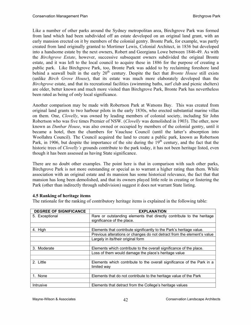
Like a number of other parks around the Sydney metropolitan area, Birchgrove Park was formed from land which had been subdivided off an estate developed on an original land grant, with an early mansion erected on it by members of the colonial gentry. Bronte Park, for example, was partly created from land originally granted to Mortimer Lewis, Colonial Architect, in 1836 but developed into a handsome estate by the next owners, Robert and Georgiana Lowe between 1846-49. As with the Birchgrove Estate, however, successive subsequent owners subdivided the original Bronte estate, and it was left to the local council to acquire these in 1886 for the purpose of creating a public park. Like Birchgrove Park, too, Bronte Park was added to by reclaiming foreshore land behind a seawall built in the early 20th century. Despite the fact that Bronte House still exists (unlike Birch Grove House), that its estate was much more elaborately developed than the Birchgrove estate, and that its recreational facilities (swimming baths, surf club and picnic shelters) are older, better known and much more visited than Birchgrove Park, Bronte Park has nevertheless been rated as being of only local significance. Another comparison may be made with Robertson Park at Watsons Bay. This was created from original land grants to two harbour pilots in the early 1830s, who erected substantial marine villas on them. One, Clovelly, was owned by leading members of colonial society, including Sir John Robertson who was five times Premier of NSW. (Clovelly was demolished in 1903). The other, now known as Dunbar House, was also owned or occupied by members of the colonial gentry, until it became a hotel, then the chambers for Vaucluse Council (until the latter’s absorption into Woollahra Council). The Council acquired the land to create a public park, known as Robertson Park, in 1906, but despite the importance of the site during the 19th century, and the fact that the historic trees of Clovelly’s grounds contribute to the park today, it has not been heritage listed, even though it has been assessed as having State significance. There are no doubt other examples. The point here is that in comparison with such other parks, Birchgrove Park is not more outstanding or special as to warrant a higher rating than them. While association with an original estate and its mansion has some historical relevance, the fact that that mansion has long been demolished, and that its owners played little role in creating or fostering the Park (other than indirectly through subdivision) suggest it does not warrant State listing. 4.5 Ranking of heritage items The rationale for the ranking of contributory heritage items is explained in the following table: DEGREE OF SIGNIFICANCE EXPLANATION
5. Exceptional Rare or outstanding elements that directly contribute to the heritage significance of the place.
4. High Elements that contribute significantly to the Park’s heritage value. Previous alterations or changes do not detract from the element’s value Largely in its/their original form 3. Moderate Elements which contribute to the overall significance of the place. Loss of them would damage the place’s heritage value 2. Little Elements which contribute to the overall significance of the Park in a
limited way 1. None Elements that do not contribute to the heritage value of the Park Intrusive Elements that detract from the College’s heritage values

Conservation Management Plan Birchgrove Park
Mayne-Wilson & Associates Conservation Landscape Architects
43
4.5.1 Table of Significant Items Representative Photograph of Item Description of Item Degree of Significance
HI 1
Sandstone block retaining wall between Grove St. and the park. Likely to have been built in conjunction with the development of the lower portion of Grove Road. Appears in its current form in photographs from the 1900s and 1910s and may date from as early as the 1860s after the subdivision of the Balmain land grant commenced.
Rating: 4 Role: An important retaining wall supporting Grove St. and defining the southern boundary of the Park. Its large, sparrow-picked blocks were probably quarried on the peninsula.
HI 2
The Terrace roadway was laid out in the first subdivision in 1860. It has retained its same form ever since.
Rating: 4 Role: This access roadway from Grove St. to the upper (western) sector of the Park was the first access through the Park site prior to any reclamation works.
HI 3
Children’s sandstone playhouse. This rustic item sits in the lower, eastern end of the southern side of the Park, but its provenance is yet to be ascertained.
Rating: 2 Role: This bit of whimsy makes no contribution to the role of the Park as a sports and recreation ground, but a small contribution to its role as a playground for children.
HI 4
Tennis court and pavilion in the south-eastern sector were constructed c.1910, reputedly for nearby St. John’s Church. The court was originally a hard-court, since resurfaced with artificial grass. It is not known what remedial works have been carried out on the original pavilion.
Rating: 3 Role: This court was not part of the original design of the Park as a sports ground but a response to pressure from a local group for the provision of a facility for their use. It is known as the Parkview Tennis Club. As that use has continued for nearly a century, it has social significance.

Conservation Management Plan Birchgrove Park
Mayne-Wilson & Associates Conservation Landscape Architects
44
Representative Photograph of Item Description of Item Degree of Significance
HI 5
Bus drivers’ rest room, on the corner of Grove Street and Deloitte Avenue.
Rating: 1 Role: This convenience has no role vis-à-vis the Park but only for drivers at the terminus of the Balmain bus route. It does, however, ‘anchor’ the south-east corner of the Park.
HI 6
Deloitte Avenue, seen from its southern end. It was built after the c.1904 completion of the reclamation works and boundary seawall for the park to provide a harbourside accessway from Grove St. to Louisa Road. Because of rock benches at the northern end, the Avenue does not join Louisa Road as a road, only via a staircase.
Rating: 3 Role: Such an access road was not proposed in the 19th century subdivision plans, but has remained in place since c. 1904. It helps define the Park’s eastern boundary and provides a pleasant esplanade along the waterfront for pedestrians to enjoy views to the city.
HI 7
Sydney Water’s sewerage pumping station adjoining Deloitte Avenue, built in the south-east corner of the Park during the mid 1910s as a matter of convenience. It is fenced off and does not contribute visually to the Park, nor is it an amenity to it.
Rating: 2 Role: Although this facility is located on the edge of the Park, it serves a wider role for the suburb beyond. It makes no heritage contribution to the Park..
HI 8
Sandstone block wall along the southern side of the oval past the tennis pavilion to the southern lawns. The date of construction of this wall is not certain, but it is likely to have been built concurrently with the reclamation works, c. late 1890s – early 1900s.
Rating: 3 Role: This eastern end of the retaining wall was not part of the original sea wall built around the northern edge of Snails Bay for the Birch Grove estate. It was built to define and contain the southern boundary of the oval from the slope behind it.

Conservation Management Plan Birchgrove Park
Mayne-Wilson & Associates Conservation Landscape Architects
45
Representative Photograph of Item Description of Item Degree of Significance
HI 9
The oval, formed as a result of the reclamation works to Snails Bay, undertaken from the mid 1880s until 1904.
Rating: 4 Role: The oval itself is the core area of the Park deliberately created for active recreation sports, especially cricket. Only the rear of it formed part of the original land grant to George Whitfield, later known as the Birch Grove Estate.
HI 10
The seawall, completed c.1904, was not the original wall built to contain the imported fill for the reclamation works. The original wall was a rough dyke wall and was probably built just inward of the current block wall.
Rating: 4 Role: This wall formally marks the eastern edge of the Park precinct, separating it from the waters of the Bay. It was built with care, has been well maintained, and has some aesthetic merit.
HI 11
The commemorative plaque for the Deloitte gates, named in honour of the widely admired local sportsman Q.L. Deloitte. The gates were built in 1930, but their material and exact structure has not yet been ascertained. They were removed early in WWII and melted down as part of the war effort.
Rating: 2 Role: These gates once served to control entry into the Park through the boundary picket fence along Deloitte Ave. Such a role lasted only for a decade. They were not replaced.
HI 12
Old staircase connecting Louisa Road (at top of image) down to Deloitte Ave. and the Bay. The actual date of its construction is not yet known. The stringers of the staircase may be older than the steps, which appear to have been recast using the concrete mix typical of the late 1920s-30s.
Rating: 3 Role: These stairs mark the eastern limit of the Park on its northern side, and provide the only pedestrian access to the Bay from Louisa Road. They are not associated with Birch Grove House and are likely to have been built in the first decade of the 20th century when the sea wall and Deloitte Avenue were constructed.

Conservation Management Plan Birchgrove Park
Mayne-Wilson & Associates Conservation Landscape Architects
46
Representative Photograph of Item Description of Item Degree of Significance
HI 13
Sandstone rubble and block retaining wall on the northern side of the oval. This wall was the first sea wall built in Snails Bay, during the mid to late 1800s, presumably by one of the owners of Birch Grove House.
Rating: 4 Role: This wall would have retained the lowest terrace of the footslope below the ridge on which Birch Grove House was built, and separated it from the tides and mud-flats of the original Bay.
HI14
Sandstone outcrop, just below Louisa Road, has a bench seat cut into its southern face. This cut may have been made during the first decades after the establishment of Birch Grove House, although no documentary evidence has yet been found to confirm this
Rating: 2 Role: This item, although indicative of the underlying rock benches that constitute the slope between the ridge and the original embayment, has a little natural and social interest, but makes no contribution to the Park’s heritage values.
HI 15
Sandstone block retaining wall along the northern pathway from Louisa Road around oval. The date of construction of this wall is unknown, but the flight of steps cut into it further to the west suggests that at least part of the wall may date from the mid to late 1800s. Note the Phoenix Palms at right.
Rating: 3 Role: This wall retains the midslope between the ridge of Louisa Rd. and the sports ground below, enabling an easy gradient pathway to be built from Louisa Rd. past the base of Birch Grove House grounds to link up with the northern arm of The Terrace to the west.
HI 16
Sandstone block retaining wall on the north-east boundary of the park supporting a property along Louisa Road. It is not known exactly when this wall was constructed, but it was in place in the 1890s. It may have been built to create a platform for Birch Grove House, but could have been built for allotments created by the subdivision of 1878 or later.
Rating: 3 Role: This retaining wall supports the grounds of a house built on a lot east of Birch Grove House following the subdivisions of the rump of that estate in the early 20th century. It forms a clear edge to the Park & demonstrates how such walls were grafted onto the rock benches between the ridge and the mudflats.

Conservation Management Plan Birchgrove Park
Mayne-Wilson & Associates Conservation Landscape Architects
47
Representative Photograph of Item Description of Item Degree of Significance
HI 17
Sandstone block steps from the northern pathway around the oval past the base of the sandstone outcrops below the Louisa Road properties and on to Louisa Road itself. As is evident, early but skilled repairs are needed.
Rating: 4 Role: These stairs may have provided the first formal pedestrian access from Birch Grove House grounds to its seawall and Snails Bay during the 1800s.
HI 18
Another example of the way in which sandstone blocks were added to the existing natural rock benches in order to create level platforms for dwellings. The quality of the stonework varies and ad hoc repairs have been made, but it is likely these walls were built in the last decade of the 19th century or early in the 20th century
Rating: 3 Role: These retaining walls support the grounds of properties built on the south side of Louisa Road. They are not shown on Water Board maps of the 1880s, so may not be associated with Birch Grove House.
HI 19
Sandstone wall north of the caretaker’s cottage (originally called Bay View House), likely to have been built concurrently with that residence. According to a Sydney Water plan of 1888), a ‘rough stone wall’ in this location originally extended further to the north It appears from the condition of this wall that it has been rebuilt in recent times.
Rating: 3 Role: A small retaining wall that provides a level terrace along part of the western slope of the Park, below the 1970s toilet block. Its predecessor may have been the rough sea wall separating the footslope from the mud-flats of the Bay, as the high water mark was closeby.
HI 20
The caretaker’s house, built originally for Mr. David Muir, in the early 1880s and known as Bay View House. This was the only house built along the northern arm of The Terrace after the 1878 subdivision.
Rating: 3 Role: The terrace house configuration reflects the narrow block pattern of the original subdivision and the row-house style of building to suit that. Its availability for use as the caretaker’s residence was fortuitous, not pre-planned.

Conservation Management Plan Birchgrove Park
Mayne-Wilson & Associates Conservation Landscape Architects
48
Representative Photograph of Item Description of Item Degree of Significance
HI 21
This small weatherboard maintenance shed has only been in this location since the late 1960s. It is not yet known if it was relocated from a position close to the junction of Ferdinand St. and The Terrace, where old plans indicate a similar WB structure was present earlier.
Rating: 2-3 Role: This shed is a functional, contributory item of the Park and has a little heritage significance. Because its materials & style suggest it may be an older structure (but relocated) it may warrant a 3 rating
HI 22
A service shed has existed in this corner for most of the 20th century, this red brick version having replaced an earlier weatherboard one. Unfortunately, its red brick colour and severely functional ‘modernist’ form are quite out of character with the rest of the Park structures, and its location at the most used entrance to the Park combine to make it visually intrusive.
Rating: Intrusive Role: Although the site and configuration of the landform behind it have long supported a service structure in this location, the actual buildings on it have changed. The present one has no heritage value. Its facilities should be moved to a less visually intrusive location, and in an architecturally more sympathetic building.
HI 23
This old ticket collection booth beside the entrance gates at the junction of Ferdinand St and The Terrace is likely to date from the time when first grade cricket matches, and also rugby league matches, were held in the Park, for which admission was charged.
Rating: 2 Role: Although of little intrinsic heritage value, this concrete ticket booth is a reminder of the days when major sporting matches drew large crowds to the Park. It thus has some social significance.
HI 24
Sandstone kerbing along the southern edge of Ferdinand St. just before it meets with The Terrace. They mark the western entrance to the Park but have only been laid here in recent times. However¸ the blocks appear old and may have been relocated from elsewhere in the area.
Rating: 2 Role: These kerb stones, are minor contributory elements but warrant retention.

Conservation Management Plan Birchgrove Park
Mayne-Wilson & Associates Conservation Landscape Architects
49
Representative Photograph of Item Description of Item Degree of Significance
HI 25
The oldest of the Park’s tennis courts, built adjacent to the corner of Rose and Ferdinand Streets. Although their configuration has been changed around, they have existed at this site since about 1902. They are currently leased out to the North Western Tennis Association.
Rating: 3 Role: These courts have both social and historical significance, having been continuously used for tennis in the same location for a century. The original timber clubhouse was replaced in the 1970s.
HI 26
These courts were not constructed until 1970, but occupy land set aside for the Park in 1881.
Rating: 2 Role: These courts have a little degree of social significance and enjoy fine views out to the Bay
HI 27
The concrete irrigation control shed, located on the eastern edge of southern arm of The Terrace. It appears to have been built in the late 1960s, though this has yet to be confirmed.
Rating: Intrusive Role: This structure serves a functional need of the Park but should be more sympathetically designed and located in a less visually sensitive location or cut into the slope so it would be partly underground.
HI 28
This crude pavilion & change room was built at the eastern side of the tennis pavilion probably in the 1940s. It replaced the early timber change room for referees, and was also used as a shelter for people waiting for the ferry. It engulfs a Camphor Laurel tree (arrowed), probably planted in the 1920s. As a pavilion, it is poorly oriented, facing due north.
Rating: 1 Role: This ugly structure, fortunately tucked into a corner, is not highly intrusive but has no heritage significance. It would be better demolished and if considered necessary, a new, sympathetically designed pavilion located in a more appropriate position.

Conservation Management Plan Birchgrove Park
Mayne-Wilson & Associates Conservation Landscape Architects
50
Representative Photograph of Item Description of Item Degree of Significance
HI 29
A small sandstone-edged garden feature near the south-east entry to the park, with the tennis court beyond. It contains the remains of a site laid out in 1977 as a Children’s Building Playground (see also item HI 3). It contained a wattle and daub hut, and was planted with bamboo since removed.
Rating: 1 Role: This feature is now irrelevant and uncharacteristic, and makes little contribution to the use or enjoyment of the Park.
HI 30
Picnic tables, chairs and rubbish bins located in a left-over space of the Park adjacent to Deloitte Ave. These are aesthetically unattractive, poorly located, and the tables in a rusted, decaying condition.
Rating: 1 Role: These functional items, although not intrusive, have negligible aesthetic or social value

Conservation Management Plan Birchgrove Park
Mayne-Wilson & Associates Conservation Landscape Architects
51
LOCATION MAP FOR THE HERITAGE ITEMS IDENTIFIED IN SECTION 4.5.1
NUMER ITEM NUMBER ITEM NUMBER ITEM HI 1 Block wall along Grove St HI 11 Deloitte plaque/gates? HI 21 Small WB maint. shed HI 2 The Terrace entry road HI 12 Staircase to Louisa Rd. HI 22 Red brick maint. shed HI 3 Children’s playhouse HI 13 First s/stone seawall HI 23 Ticket coll’n booth HI 4 Tennis court & pavilion HI 14 Carved s/stone outcrop HI 24 Sandstone kerbing HI 5 STA Drivers rest room HI 15 Mid-slope retaining wall HI 25 3 orig. tennis courts HI 6 Deloitte Avenue HI 16 Upper retaining walls HI 26 1970s tennis courts HI 7 Sewerage pump station HI 17 Stairs to Birch Grove Hs HI 27 Irrigation control shed HI 8 South retaining wall HI 18 Late 19c. retaining walls HI 28 Ad hoc conc. pavilion HI 9 The oval HI 19 Western retaining wall HI 29 Garden feature
HI 10 1904 Sea wall Hi 20 Caretaker’s residence HI 30 Picnic tables & bins

Conservation Management Plan Birchgrove Park
Mayne-Wilson & Associates Conservation Landscape Architects
52
4.6 Significant Trees Representative Photograph of Item Description of Item Degree of Significance
T1
Trees around the northern boundary of the ‘pocket park’ on the southern side of the corner of Rose and Ferdinand Streets. These trees appear semi-mature in the 1930 aerial photo and may been planted in the 1920s. The tree on the left is an Elm and to its right a Ficus obliqua. The rest are Brush Box.
Ranking: 3 Role: Contributory items that help define the entry to the Park as well as the perimeter of this subsid-iary open space. They also screen built items and help channel the view to the Harbour.
T2
Mature trees including Camphor Laurels, Brush Box and Pepper Trees on the corner of Rose Street and Grove St., most of which appear semi-mature in the 1930 aerial photograph. They were probably planted in the period 1910 – 1920s.
Ranking: 3 Role: Contributory items that define the south-west boundary of the Park and provide amenity to this corner of it. They also ameliorate the impact of surrounding built form beyond it.
T3
Multi-trunked Queensland Umbrella tree (Brassaia actinophylla) (at right, and Holm Oak (Quercus ilex) at centre, two of the early plantings (c. 1910-25) in the Park, already visible as semi-mature in the 1930 aerial photograph.
Ranking: 3 Role: Contributory items of historical and aesthetic value that provide amenity and visual softening to this otherwise plain precinct of the Park.
T4
Two mature Jacaranda trees (Jacaranda mimosaefolia) on the south-west slopes of the Park, which appear to have been planted in the period 1930-1950.
Ranking: 2 Role: Items of modest historical and aesthetic value that have contributed to the amenity and visual quality of the south-west slopes of the Park for over half a century.

Conservation Management Plan Birchgrove Park
Mayne-Wilson & Associates Conservation Landscape Architects
53
Representative Photograph of Item Description of Item Degree of Significance
T5
Mature trees along the Grove St park boundary, including Brush Box and Ficus species. Most of these appear to be young to semi-mature in a 1930 aerial photograph.
Rating: 3 Role: Contributory items helping to define the southern boundary of the Park and providing some amenity and sense of enclosure, as well as some screening of built items along Grove St.
T6
Camphor Laurels (left) and a Coral Tree between the tennis court and Grove Street. All these plantings appear as semi-mature or mature in a 1930 aerial photograph of the site, and may be plantings from c.1910. One senescent Camphor Laurel & the Coral tree are damaged & will soon be removed.
Rating: 3 Role: Contributory items helping to define the southern boundary of the Park and providing some amenity and screening of built items along Grove St.
T7
This line of seven Fig Trees along the western side of the southern half of Deloitte Avenue was planted in the 1920s, and the one Brush Box was interplanted slightly later, as an infill for a failed Fig.
Rating: 3 Role: Contributory items helping to define the eastern boundary of the Park and providing some amenity and framing of views to the Harbour from the western slopes of the Park.
T8
The large old Fig Tree, flanked by later Brush Box plantings, at the northern end of the eastern boundary of the Park, outside the picket fence and adjacent to Deloitte Ave. This Fig appears as semi-mature in the 1930 aerial photo, but not in images of the Park grounds before 1910. It was probably planted about then.
Rating: 3 Role: The oldest and grandest contributory item to the eastern boundary of the Park, it frames views to the Harbour from the western slopes of the Park. It also provides welcome shade and amenity.

Conservation Management Plan Birchgrove Park
Mayne-Wilson & Associates Conservation Landscape Architects
54
Representative Photograph of Item Description of Item Degree of Significance
T9
One of the oldest Fig trees at the northern corner of Snails Bay, it actually lies within private property, on the eastern side of Deloitte Ave.
Rating: Not directly applicable, since it lies outside the Park. Role: This tree, together with that described above, makes a major visual contribution to the setting and sense of enclosure to the Park.
T10
A good specimen of Forest Red Gum (Eucalyptus tereticornis) probably planted c. 1970. Although of good form and mature, it is not endemic to the area and is not a remnant or regenerated species of the original open forest.
Rating: 2 Role: This attractive, clean-trunked tree is a welcome addition to the north-west upper slopes of the Park from which earlier mature trees have been removed over the last few decades.
T11
This Hills Fig (Ficus Hillii) lies just inside the grounds of the Park near the upper tennis courts. It does not appear to have been part of any deliberate street tree or park planting.
Rating: 3 Role: From its size (canopy and trunk) and location, this tree appears old enough to have been a planting associated more with former Birch Grove House than the Park.

Conservation Management Plan Birchgrove Park
Mayne-Wilson & Associates Conservation Landscape Architects
55
Representative Photograph of Item Description of Item Degree of Significance
T12
Five mature Brush Box trees along Louisa road, on the northern boundary of the Park. From aerial photos, it appears these trees were planted here in the 1920s.
Rating: 3 Role: These trees define the north -east edge of the Park, helping to provide a sense of enclosure and to soften and partly screen the built forms across Louisa Road. They also provide shade and amenity to this oddment of space.
T13
A short row of mature Phoenix palms abutting the pathway from the Louisa Street entry to the park. It seems likely these are some of the trees planted at the instigation of Q. L. Deloitte and A. Fitzhardinge in the 1920s.
Rating: 3 Role: These Palms were planted to flank the pathway down from Louisa Road into the north-west sector of the Park. They were favourite plantings of the period 1910-1930.
T14
A very old Fig (Ficus obliqua) abutting the pathway from the Louisa Street entry to the park. From its girth, it appears to be one of the oldest Figs in the Park,
Rating: 4 Role: This Fig is possibly associated with the grounds of former Birch Grove House, and appears to date from the 19th century.

Conservation Management Plan Birchgrove Park
Mayne-Wilson & Associates Conservation Landscape Architects
56
Representative Photograph of Item Description of Item Degree of Significance
T15
One of several very old Figs growing on the slopes to the north of the sports oval. These Figs appear in photos of Birch Grove House from the late 1800s.
Rating: 4 Role: This Fig (Ficus Hillii) is associated with the grounds of former Birch Grove House, and appears to date from the 19th century. It is in poor condition, though appears to be recovering somewhat.
T16
Another Hills Fig along the northern pathway, below the grounds of Birch Grove House.
Rating: 4 Role: This Fig (Ficus Hillii) is associated with the grounds of former Birch Grove House, and appears to date from the 19th century.
T17
A very old Olive in front of the 1970s toilet block,
Rating: 4 Role: This tree is likely to be associated with the early orchard of the Birch Grove estate.

Conservation Management Plan Birchgrove Park
Mayne-Wilson & Associates Conservation Landscape Architects
57
LOCATION MAP FOR SIGNIFICANT TREES IDENTIFIED IN SECTION 4.6
NUMBER ITEM NUMBER ITEM
T1 Brush Box, Ferdinand St T11 V. old Hills Fig, Louisa Rd T2 Pepper & Camphor Laurels SW corner T12 Row of 5 Brush Box, Louisa Rd. T3 Holm Oak & Qld. Umbrella Tree T13 Row of Phoenix Palms, northern pathway T4 2 Jacarandas T14 Birch Grove Estate Fig T5 Camphor Laurels & Brush Box, Grove St. T15 Birch Grove Estate Fig T6 Trees between tennis court & Grove St. T16 Birch Grove Estate Fig T7 2 Figs & 2 Brush Box, SE sector T17 Birch Grove Estate European Olive T8 Oldest 20th century Fig Tree, NE sector T9 V. old Fig Tree, NE corner (outside park) T10 1970s Red Gum, north-western slopes

Conservation Management Plan Birchgrove Park
Mayne-Wilson & Associates Conservation Landscape Architects
58
5.0 Obligations arising from Significance 5.1. Obligations As assessed in Section 4 above, Birchgrove Park is a place of high local significance. It has a broad range of cultural values that are summarised in the Statement of Significance. The significance of the Park gives rise to an obligation for conservation. This obligation extends to retention of all identified specific aspects of significance, including: • retention of physical evidence; • maintenance of historical associations; • recognition of all site elements, including landscape, built structures, records and
associations; • involvement of interested people; and • interpretation. The above assessment of the Park has identified both the place as a whole and numerous contributory elements within it, as listed in the Significance Tables, as having varying degrees of heritage significance. It is important that these should be acknowledged by Council, and taken into account in future management and maintenance strategies and actions. The NSW Heritage Act 1977 and the Leichhardt LEP 2000 both provide statutory protection for items listed as having State and local heritage significance. There are obligations on control authorities to protect and conserve such items and places, and to manage and maintain them in a manner which retains their significance. Generally, the higher the ranking which such items or places are assessed as having, the greater the degree of protection and conservation is required. 5.2. Constraints and Opportunities The conservation planning process established by the guidelines to the Burra Charter of Australia ICOMOS and set out in the NSW Heritage Manual requires that relevant constraints and opportunities be identified as part of the process for developing conservation policies for places of significance. This section of the report sets out the key constraints and opportunities that affect the Park. 5.2.1 Constraints Arising from Heritage Significance
The constraints are not conclusions or recommendations, but rather observations relevant to the circumstances of the site and matters which require consideration and resolution. None of these form
conservation policies in themselves. An appropriate conservation policy is a result of a careful balanced assessment of the various factors identified.
Constraints arising from significance establish a premise whereby other factors such as physical condition and client requirements can be considered. The constraints identified below arise from the need to retain the significance of the Park. 5.2.1.1 Heritage Processes to Retain Significance There is a need to
• Recognise the Park as a place of heritage significance which should be managed in accordance with accepted conservation processes and principles. This should include appropriate statutory protection for the place as a whole and for individual elements according to their assessed levels of significance.

Conservation Management Plan Birchgrove Park
Mayne-Wilson & Associates Conservation Landscape Architects
59
• Manage individual contributory elements within the Park in accordance with their assessed level of significance (Exceptional, High, Moderate, Little, None, or Intrusive). (Where different heritage significance values overlap and there is a conflict between different values then the higher value should be the determining factor in making decisions.)
• Ensure that decisions about works to each element (including maintenance, subsurface excavations, repairs or more extensive adaptation works) always take into account the impact on the significance of the place, both as a whole and on individual components.
• Ensure that any new development of the place retains the significance of the place as a whole in addition to the significance of individual contributory elements.
5.2.1.2 Respect for the Cultural Landscape There is a need • to acknowledge the site as a cultural landscape (a landscape area extensively modified by
man). Its structure, context and setting are of the utmost importance. • for the overall site to be able to be 'read' and interpreted in the future as a public recreation
ground established both from part of the former Birch Grove estate and land reclaimed from Snails Bay.
• to pay careful attention to the various view corridors from different parts of the site out to the surrounding landscape and Harbour, as well as into and within the site..
• to retain as much as possible of the remnant fabric of the grounds of former Birch Grove House, including retaining walls, stairs, and plantings (mostly Fig Trees) on the northern edge of the Park.
5.2.2 Other Factors In addition to the obligation arising from significance, the following factors should be considered when developing conservation policy: • the physical constraints arising from the condition of components, • external factors, including relevant council statutory and non-statutory controls; and • feasible uses and client requirements. 5.2.2.1 Physical Constraints These factors relate to the physical condition of the structures and landscape components. They include the various 19th and early 20th century sandstone retaining walls, the c. 1910 tennis pavilion and court, the tennis courts adjacent to Rose Street, and the many mature trees - especially those planted by owners of Birch Grove House in the 19th century and those planted by the Park Trust in the period 1905 - c.1925. The present well-maintained condition of the Park and its components indicates there should be little difficulty in achieving the objective of conserving significance, such as would occur if they had deteriorated beyond repair – which, fortunately, they have not. The above factors generate the following constraints: • the need to review and maintain a regular maintenance program for identified heritage
structures and landscape components for the future; and • the need to investigate in detail the physical condition of individual elements prior to
formulating any proposal for works to these structures and landscape components.

Conservation Management Plan Birchgrove Park
Mayne-Wilson & Associates Conservation Landscape Architects
60
5.3 Statutory Controls There are a number of statutory and non-statutory controls which may affect future development of the site. They generate a need to take into account the detailed provisions of these controls prior to formulating any development proposal. 5.3.1 NSW Heritage Act The NSW Heritage Act 1977 was established to conserve the environmental heritage of the State. This includes buildings, works, relics, trees or places which satisfy the criteria listed in section 4 above. Section 57 of the Heritage Act forbids persons to do certain things if covered by an appropriate conservation instrument. These include
(a) demolishing the building or work, (b) damaging or despoiling the place, precinct or land, or any part of the place, precinct or land, (c) moving, damaging or destroying the relic or moveable object, (d) excavating any land for the purpose of exposing or moving the relic, (e) carrying out any development in relation to the land on which the building, work or relic is situated, the land that comprises the place, or land within the precinct, (f) altering the building, work, relic or moveable object,
(g) displaying any notice or advertisement on the place, building, work, relic, moveable object or land, or in the precinct, (h) damaging or destroying any tree or other vegetation on or removing any tree or other vegetation from the place, precinct or land.
The Minister, on the recommendation of the Heritage Council may, grant an exemption from the prohibition on some of these activities. Once the heritage value of a place and particular items has been identified and listed, a council can also, under delegated power, take advantage of the exemptions, which allow ordinary, everyday maintenance to occur. (For specific guidance, consult the NSW Heritage Office document Standard Exemptions for Works Requiring Heritage Council Approval, issued in 1999 but revised in 2004.) Section 118 of the Heritage Act, as amended, deals with minimum standards of maintenance and repair in order to protect heritage items and places. Section 139 is of particular relevance to any proposed earthworks or subsurface works (e.g. for drainage channels, service lines and roadway construction). It states that an excavation permit is required in certain cases, mostly relating to the possible likelihood of relics being discovered. However, the Heritage Council may create exceptions to this section, if there is little likelihood of there being any relics in the land, or they are unlikely to have State or local heritage significance. Section 146 of the Act imposes an obligation to notify the Heritage Council of the discovery of relics and provides relevant information about it.

Conservation Management Plan Birchgrove Park
Mayne-Wilson & Associates Conservation Landscape Architects
61
Other Statutory Plans & Policies 5.3.2 Leichhardt LEP 2000 The Leichhardt Local Environmental Plan (LEP) 2000, Part 3, clause 15, contains objectives for the conservation of heritage properties. The general provisions for the development of land containing heritage items are set out in clause 16. 5.4 Non-Statutory Plans & Policies 5.4.1 The Burra Charter This Charter, prepared by Australia ICOMOS, was first prepared in 1977-78 for the conservation and management of places of cultural significance, and was revised in 1999. It sets a standard of practice for those – including owners, managers and custodians - who provide advice, make decisions about, or undertake works to places of cultural significance. Its use and application are further explained in Guidelines to the Charter, including those dealing with conservation policy. Its basic premise is that places of cultural significance – including natural indigenous and historical places – must be preserved for future generations. Generally, it advocates a cautious approach to change, its motto being: “do as much as necessary to care for the place and to make it useable, but otherwise change it as little as possible so that its cultural significance is retained”. The Charter provides a set of conservation principles (articles 2 to 13), conservation processes (articles 14 to 25) and conservation practices (articles 26 to 34). Those who have responsibilities for the management and maintenance of places of cultural/heritage significance should familiarize themselves with the provisions and guidelines of that Charter. It should be noted that article 16 of the Charter states that “maintenance is fundamental to conservation and should be undertaken where fabric is of cultural significance and its maintenance is necessary to retain that significance”. The previous article (no.15) recognizes that change may be necessary to retain cultural significance, but is undesirable where it reduces it. The amount of change should be guided by a place’s cultural significance and its appropriate interpretation. Changes which reduce cultural significance should be reversible, and be reversed when circumstances permit. Demolition of a significant item or place is generally not acceptable. 5.4.2 National Trust of Australia (NSW) The Park was formally classified in the Register of the National Trust in 1988 – for details of that listing, see Appendix B. Although inclusion of places in the Register does not have any legal effect, it is widely recognized as being an authoritative statement on the significance of a place. The purpose of the Register is to alert responsible authorities, property owners and the public so that those concerned may adopt measures to preserve the special qualities which prompted the listing. When the significance of a place is under threat, the Trust will take whatever action is deemed appropriate to ensure its protection, including giving advice to the property owner and seeking the use of the State Heritage Act or the planning powers of the local authority. It is desirable that those responsible for the management and maintenance of heritage places bear this in mind.

Conservation Management Plan Birchgrove Park
Mayne-Wilson & Associates Conservation Landscape Architects
62
5.5 Client Requirements & Feasible Uses The client in this case is Leichhardt Council, acting on behalf of the residents in the local government area and other interested persons such as Park users, particularly of its various sporting facilities. The principal requirement is to maintain and enhance the cultural significance and values of the Park, especially those of its contributory elements of high or moderate significance. More generally, the Council wishes to ensure that the Park is an attractive, well-used place where residents can go for relaxation and refreshment, and sports players can participate in active recreation. 6.0 Conservation Policy 6.1 Principles Defining a conservation policy for the Park requires resolution of the constraints and opportunities summarized above. In addressing the appropriate policy approach for the conservation of the cultural significance of the Park, it is worthwhile to consider what The Illustrated Burra Charter says about the importance of place:
One of the fundamental reasons for conserving places is that they contain information that documents, photographs, drawings, film or video cannot. Regardless of how skillfully a place may be captured on film or how evocatively it may be described, there is no substitute for the experience of the actual place.
In short, there is nothing more important or pressing about the management of the Park than the obligation to preserve it and its important contributory elements. While it is important to recognize that interpretation of the site, and communication of information about the place to the wider community, is an integral element of conservation, primacy must be given to caring for the place. Having regard to the constraints set out earlier in this Section, and the above conservation imperatives, the following principles are identified as the basis for the conservation policy:
• Conservation must be a major management objective at the Park • Management of the Park should set standards in best-practice conservation. This can be
reflected in the use of well-accepted conservation guidelines and the application of traditional skills, innovation, multi-disciplinary approaches and well-documented systems (that do not rely on the memory of people).
• Resourcing needs must be identified and sourced.
If conservation is the primary objective, essential conservation activities and works should not be determined by the current limits imposed by funding, or other similar financial constraints. Efforts should be made to seek funding, grants and donations from a range of local and regional sources. • Conservation of the Park must extend to the total resource. The Park includes the built elements, landscape, and mature plantings, along with memories and associations, and current uses and activities. Conservation of the place must extend to all of these elements and attributes if cultural significance is to be retained in the long-term.

Conservation Management Plan Birchgrove Park
Mayne-Wilson & Associates Conservation Landscape Architects
63
• Decision-making must be based upon proper understanding of cultural significance All management decisions which have the potential to affect the heritage values of the place should be founded on a clear understanding of those values. The heritage impact of decisions should be stated and evaluated as part of the decision-making process. • A cautious approach is required where actions may have adverse heritage impacts Where management actions or decisions may result in a loss of cultural significance, these actions should be reversible or, at the very least, should adopt a cautious approach. The precautionary principle emphasises the need for caution in making decisions which may damage the environment over time. If there are any threats of serious or irreversible damage, lack of scientific certainty should not be used as a reason for postponing measures to prevent such damage. • The physical condition of the Park should be monitored Monitoring of the physical condition of the site, over time, will provide both a measure of the effectiveness of conservation actions and essential data for future decision-making. In conjunction with considerations of the physical cultural and natural environment, the appropriateness and effectiveness of visitor services/interpretation actions should be monitored - the aim being to achieve better conservation and improved visitor experience, concurrently. • Review Council should make this CMP accessible to the public through a process of public exhibition, and take into account comments and proposals made in response to it prior to its finalisation. The CMP should be reviewed every five years to ensure that its endorsed recommendations have been correctly carried out, and that its management and maintenance strategies and guidelines are still appropriate or require adjustment. 7.0 Conservation Management and Actions 7.1 General As a general rule, all culturally significant fabric within the Park must be retained and conserved. No activity or intervention should be instigated without reference to this Conservation Management Plan. Proposals for the Park’s future use should enable its key heritage fabric and elements to be conserved and no significant alterations to its elements of high significance should be permitted. As much original fabric as possible should be conserved and any further interference kept to a minimum. The repair, restoration or reconstruction of original elements should be undertaken according to the guidelines provided in the following table. It should be possible to provide original materials in restoration work, since these are readily available locally.

Conservation Management Plan Birchgrove Park
Mayne-Wilson & Associates Conservation Landscape Architects
64
7.2 Table 2 Recommended Conservation Actions and Works
Item Heritage Rating
Action Required Priority
Sandstone block wall along Grove St 4 Monitor annually, replace mortar or stone with same type as necessary
Routine
The Terrace (roadway and kerbs) 4 Monitor annually; maintain original alignment. Do not add structures or large tree plantings to eastern verge
Routine
Children’s sandstone playhouse 2 Worth conserving if valued or used Routine S-E tennis court and pavilion 3 Pavilion should be monitored and
repaired with same materials as req’d Routine
Crude concrete pavilion, S-E corner 1 Remove and provide low pavilion on northern slopes if still required today
Priority
Round garden bed with shrubs and sandstone edge, S-E corner
1 Serves no useful purpose. Can be removed.
Routine
Deloitte Avenue 3 Maintain original alignment; limit to pedestrian use. Keep shrubs to 1.5m
Routine
Water/sewerage pumping station 2 Responsibility of Sydney Water Liaise S-E sandstone block retaining wall along south edge of oval
3 Monitor annually, replace mortar or stone with same type as necessary
Routine
The oval 4 Maintain present boundaries; mow, fertilize and repair as necessary
Routine
The Sea Wall 4 Monitor & advise responsible authority of need to repair as needed.
Routine
Old staircase to Louisa Road 3 Monitor and repair with same materials as necessary
Routine
Old sandstone rubble retaining wall along oval’s northern boundary
4 Monitor annually, replace mortar or stone with same type as necessary
Routine
Middle sandstone block retaining wall along northern pathway
3 Monitor annually, replace mortar or stone with same type as necessary
Routine
Upper sandstone block retaining walls
3 Liaise with property owners and jointly fund necessary repairs
Priority
Sandstone block steps in centre of middle sandstone retaining wall
4 Repair treads & surrounding wall on both sides as required. Use same mortar & weathered stone as original.
Urgent
Sandstone block wall north of caretaker’s residence
3 Monitor and repair as required Routine
Caretaker’s residence 3 Monitor and repair/conserve with same materials as originally used
Routine
Square weatherboard maintenance shed near entrance
2-3 Monitor and repair/conserve with same materials as originally used
Routine
Red brick maintenance shed & toilet Intrusive Remove & relocate functions to out-of-sight location
Priority
Old ticket collection booth 2 Can be retained; needs interpretation Routine Sandstone kerbing along Ferdinand St. entrance
2 Monitor and repair/conserve with same materials as originally used
Routine
Ferdinand Street entrance 2 Redesign & add trees on south side Priority Rose St. tennis courts 3 Monitor and repair as required Routine Louisa Rd. tennis courts 2 Monitor and repair as required Routine

Conservation Management Plan Birchgrove Park
Mayne-Wilson & Associates Conservation Landscape Architects
65
7.3 Management and maintenance of all significant trees Regular inspections All the trees listed as significant in section 4.6 should be inspected annually by a well qualified and experienced arborist. Every effort should be made to maintain and prolong the life of the heritage-rated trees, which should not be removed just because their SULE (safe and useful life expectancy) rating may be relatively low. Their contextual, social, aesthetic and historical values must also be considered. Remedial Action Pruning and removal of dead branches should be done in the cooler months, and insect and fungal infestations dealt with appropriately as soon as signs of attack appear. The Hills Figs are susceptible to attack from the Phellinus species (a white rot fungus), and Armillaria inteobubalina, which resides in the soil and causes root rot. Phytophthora cinnamomi can also be present. It is understood that a few of the Hills Figs have been attacked by one of these fungal agents, and as no cure or control has yet been devised, they may have to be removed soon if they are considered to be in danger of toppling over. Tree Replacement Generally, if significant trees become senescent and fail, they should be replaced by the same species, if the distinctive, historic character of the Park is to be retained. However, when the 19th century Fig Tree plantings along the northern boundary fail and have to be removed, difficult decisions will arise. If fungal agents are proven to be present, then the choice is either to excavate and remove all the infected soil (very difficult in this rock-benched location) or to replace them with a different species which is immune to the particular fungus. However, not enough research has yet been done to be certain which such species are. A complicating factor is that the soil at this location is in continual shade, caused partly by the overhanging rock benches, retaining walls and tall buildings along Louisa Road, and partly by the density of the present tree canopies. Being on a south-facing slope anyway exacerbates the problem. Even if fungal infection is not present, or can be dealt with by soil replacement or remediation, consideration could be given to replacing them with smaller growing Figs, such as Sandpaper Fig. (Ficus fraseri) or Rock Fig (F. platypoda). This is because the height of the canopy of the present over-mature Figs is such as to interfere with views to the Harbour and City from houses along the south side of Louisa Road. Given the high dollar value of such views, the removal of the tall existing trees would be welcomed by some house owners, but their replacement with the same species – with the future prospect of a return to view impairment – would not. Covert means of ensuring that they did not reach that stage cannot be excluded. Beyond these technical and aesthetic considerations, however, lies the issue of historical values, particularly the ability of the over-mature Figs to demonstrate, and facilitate people’s future ability to interpret, the former presence of Birch Grove House and its grounds. With the demolition of that house in 1967 and its replacement by a block of flats, the only remaining fabric are the Figs, the original seawall along the northern edge of the mudflats, and possibly some steps and the sandstone block retaining walls on the upper slopes, to demonstrate its former existence. Although it can be argued that the replacement of the Figs by identical species is essential to retain the ability to interpret the former presence of Birch Grove House, it is less certain that such action would be germane to retaining and interpreting the heritage significance of Birchgrove Park.

Conservation Management Plan Birchgrove Park
Mayne-Wilson & Associates Conservation Landscape Architects
66
While on the one hand provision for a park was contained in the 1878 subdivision launched by the owners of the House, this was essentially the low-lying land just beyond the mudflats at the head of Snails Bay, which could not be used for residential purposes anyway. On the other hand, it was the State authorities who purchased in 1881 many of the blocks of the 1878 subdivision in order to create it, and who assisted the Birchgrove Park Trust (established in 1882) to reclaim the mudflats in order to extend it into a generous-sized sports oval. Nevertheless, the then current owner of Birch Grove House, J. L. Adams, did surrender the lower slopes of the grounds of his House to the Park in 1886, and this land contained the old Fig Trees in question. While the presence of the Fig Trees clearly does evoke, and demonstrate, the former presence of Birch Grove House and the contribution which that estate made to the background formation of the Park, the question arises as to whether they are germane to the interpretation of the Park itself. For instance, would people’s ability to understand and interpret the history of the Park be reduced by their replacement with smaller or other species which made a similar aesthetic/visual contribution to the sense of enclosure and setting of the Park? For people impressed by the historical role of the Birch Grove Estate, the answer may well be ‘yes’. For those focussed on the role and development of the Park itself as a recreational reserve, created once the Estate was subdivided away, the answer may be ‘marginal’. The issue is complicated because there was a series of subsequent plantings in the period 1905-c.1925, the earliest of which were also Fig Trees, along the eastern boundary of the Park. These were not planted in the 19th century but planted for the benefit of the Park. They have no direct association with Birch Grove House or its grounds, although its plantings clearly influenced the taste of those like Q. L. Deloitte, whose father leased that house some years previously and where he himself probably grew up. The inevitable organic decay and senescence of the 19th century Figs will force a decision before long. It may well be that practical matters such as hostile fungal agents in the soil, excessive shade, and some unsympathetic residents, may prove the determining factors for which replacement species should eventually be used. Should scientific advice be that the existing species should not be replanted, then alternatives need to be considered. Dark green leaved trees which would create much the same visual effect but which do not grow nearly as tall or spreading as the present Figs could be used. These could include such genera as Holm Oak (Quercus ilex) or Brown Pine (Podocarpus elatus), but it is not certain that they would prosper in the shaded conditions of the south-facing slope below Louisa Road, nor that they would be resistant to a fungal agent if proved to be present there. Brush Box (Lophostemon confertus) may also be used, but not solely, as its canopy is not dark enough to retain the framing effect of substantial dark green trees along this northern boundary. It may also not prosper in this situation either. Turning to the Park’s southern boundary, the Camphor Laurels, which were favoured plantings of the early 20th century, can be used to replace existing ones which have failed there. There is no evidence that they have become invasive, so can be retained, but should not be used elsewhere in the Park. On the eastern boundary, the present Fig Trees have some heritage significance, and to a lesser extent the inter-planted Brush Box trees. No additional trees should be added along this boundary, as it is important to retain the present visual access to the Harbour beyond. As the present trees are not approaching senescence, the question of their replacement does not yet arise. Should it

Conservation Management Plan Birchgrove Park
Mayne-Wilson & Associates Conservation Landscape Architects
67
eventually do so, it is recommended that it be with the same species if the historic character of the Park is to be preserved. As for the western boundary, there is scope here for new or replacement plantings, as practically all of the original ones have been removed. The species of trees should be drawn from within the present palette of trees in the Park, but not those likely to exceed 8 metres in height. This would exclude the larger Figs, and also most Eucalypts. Suitable trees would include Holm Oak, Brown Pine, and the Sandpaper and Rock Figs mentioned previously, as a fairly dense, dark-green canopy is needed to carry through the same effect of the enclosing and screening trees as along the northern boundary. Appropriate species for future plantings Jacarandas and Holm Oaks have been planted in the southern sector of the Park, and would be suitable for use in certain locations. The Jacarandas could be used in other parts of the southern sector, although not along the boundaries of it. Holm Oaks would be appropriate to use on the northern and western boundaries and in other locations where a rich, dark green colour and texture would provide a strong visual framework and setting for the Park. Although Pepper Trees and Umbrella trees have also been used historically, their forms and leaf types are too different from the prevailing trees to be suitable for use in future. It is also not recommended that Elms be used, as they are prone to fungal attack and their bare branches in winter weaken the visual strength of the bold evergreen plantings around the boundaries. Eucalypts and other native trees Although it is general Council policy to use native species in public open spaces, they have not been part of the Park’s plantings from the outset. Nor did more than a handful of native trees survive the clearing and farming operations by the owners of Birch Grove House during the 19th century, and any that did remain were removed when the Park was created. There are also aesthetic reasons why native plants (apart from Brush Box) are not appropriate. An important aspect of the Park’s character is the visual strength of its dense, dark-green canopied plantings that so clearly define and enclose its boundaries. Eucalypts and nearly all other native plants do not provide this. Their trunks and canopies are usually thinner and often erratic in shape, and their colours lighter or greyer. Few have a reliable sculptural form. Another consideration is that most Eucalypts will reach a height where their canopies will interfere with the views to the Bay from residences clustered around the perimeter of the Park. This could make them targets for poisoning or removal. Shrubs and small, light green native trees are also not considered suitable for use in this Park. They are too small in scale and weak in colour and/or form to contribute positively to the prevailing parkland character, which depends on the presence of tall, stately dark green trees with a bold sculptural form, contrasted against the light green of the oval and grassed slopes. As is already apparent, the Callistemon plantings also the eastern side of The Terrace, although pleasant enough in themselves and suitably low so as not to impede views out from the terrace houses to the Bay, make a negligible visual contribution to the historic parkland character of Birchgrove Park.

Conservation Management Plan Birchgrove Park
Mayne-Wilson & Associates Conservation Landscape Architects
68
7.4 Park Structures Today there are relatively few buildings located within the Park, the principal ones being the old tennis pavilion at the south-eastern end, the small square maintenance shed near the caretaker’s residence, and the red brick maintenance and toilet complex at the entrance to the oval. There are also functional buildings servicing the tennis courts adjacent to Rose Street and Louisa Road, which are of no heritage significance. Both the c.1910 tennis pavilion and the small square maintenance shed are clad with weatherboard, which requires periodic maintenance and repainting, and occasionally replacement of damaged elements. They provide a pleasant reminder of the early period of the Park, being of an architectural style favoured in the first two decades of the 20th century, and contribute to its character and sense of place. By contrast, the red brick maintenance and toilet complex are visually disruptive and quite out of character with the rest of the Park. Given that these functions are still required, a building to house them needs to be provided, but in a different location. It is suggested that it be built in a location to the north of the existing 1970s toilet block, near where the former weatherboard change rooms once stood. It would need to be of a design sympathetic to the nearby buildings, both in colour and roof form. An alternative location could be between the caretaker’s residence and the old ticket booth, close to the eastern side of the tennis courts adjacent to Rose Street, since this is an empty space and out of the visual catchment to the Bay. It would be desirable to reintroduce plantings to this area, using screening species such as Pittosporum undulatum or Elaeocarpus reticulatus. A few small Figs could also be used, such as Ficus fraseri or F. platypoda and/or Podocarpus elatus or Quercus ilex. The Park Entrance This entrance, although the principal point of vehicular arrival and exit for the Park, is the poorest, in terms of character and visual quality. Early on, it was graced by plantings along both sides of Ferdinand St., but those along the northern edge were removed many decades ago to widen the roadway. This was most unfortunate, since it created a lop-sided effect, and exposed the unattractive foundations and mesh of the adjacent tennis court. It is recommended that this entrance, including the entry gates, ticket booth and junction with The Terrace be redesigned by a landscape architect with heritage training and experience (not one intent on demonstrating contemporary, cutting-edge skills). Northern Boundary Retaining Walls It is evident that some of the sandstone retaining walls built on top of the original sandstone benches at the southern edge of the Louisa Road ridge are in poor condition, and will require remedial work before long. The large sandstone block retaining wall at the most eastern end is in a particularly poor condition, with some blocks apparently missing. Although these walls are thought to belong to, and be the responsibility of, the private property owners of the lots that abut the Park, it is understood to be usual practice for neighbours to share the cost of maintaining and repairing fences or walls that mark the boundary of adjacent properties. If this should be the case, then Council should consider entering into negotiations with the owners of those properties to conserve and maintain these walls, the more significant ones historically being along the eastern sector.

Conservation Management Plan Birchgrove Park
Mayne-Wilson & Associates Conservation Landscape Architects
69
8.0 Interpretation Now that the heritage elements and values have been clearly identified, and sufficient historical images collected which illustrate these, it is possible to devise an appropriate interpretation strategy. This strategy should focus on the two principal aspects of the Park’s significance, namely the original role of the Birch Grove Estate as source of part of the land and setting for the Park, and the acquisition of some subdivided lots and reclamation of the Snails Bay mudflats by the State government deliberately to create a large public recreation ground for active sports – a use that has continued uninterruptedly for over a century. Given that the Park has no built element which could be converted into an interpretation center that could house an interpretative exhibition, and given its wide open space, active sportsground usage, an alternative strategy would be to have prepared a number of interpretative signs which can be placed at appropriate places within the Park. These can contain images which would depict the important heritage element in view, and text that briefly explains its origins, role, and significance in the appropriate thematic context. The signs can be supplemented by a tourist heritage walk brochure issued either by the Council library or other appropriate municipal or tourist information center. An example of this type of sign, prepared by the present consultant for a landscape heritage walk at Harris Park (near Parramatta) is provided below. These have proved to be very durable and vandal resistant. The colour of the frame and background can be selected to suit the Park. Preparation of such signage, however, would need to be the subject of a future commission.

Conservation Management Plan Birchgrove Park
Mayne-Wilson & Associates Conservation Landscape Architects
70
Further Investigation and Research Given the amount of historical material already available, and given the few and relatively simple structures erected in the Park over time, it is not considered likely that specific archaeological or technical investigations within the Park would need to be undertaken. Controls on Intervention While no particular intervention has been recommended, other than redesigning the Ferdinand St. entrance and relocating and designing the main maintenance shed, the general principle for intervention is based on the Burra Charter’s injunction to “do as much as necessary to care for the place and to make it useable, but otherwise change it as little as possible so that its cultural significance is retained”. Moveable items. There are no moveable items of heritage significance in the Park.
Conservation Management Plan Birchgrove Park
Mayne-Wilson & Associates Conservation Landscape Architects
71
APPENDIX A
Checklist of Practices for Managing Landscape Heritage Elements
1. Read Table 2 – Recommended Actions and Works to identify which works should be done first.
2. Consult section 4.5 or 4.6 to ascertain details of the heritage values of the item to be worked
on.
3. If in doubt about a proposed action, consult the heritage planner or a heritage professional. Remember the dictum: change only as much as necessary, but as little as possible.
4. Take preventative action to avoid or arrest deterioration of heritage trees or elements such as
paths, fences and grassed areas before irreversible damage is done.
5. Do not remove a significant tree or demolish a significant element without prior consent from the heritage planner.
6. Usually, failed plants should be replaced with the same species, except where a change is
recommended. In certain cases, a species with a similar character but lower height may be used.
7. Hard elements such as sandstone kerbs should be retained, or if they have to be removed,
stored for future use to replace others that have failed. If replacements are not available, they should be cut from sandstone present near the site.
8. Remember that views out of, into, and within the site are also important, and should not be
blocked or interrupted by inappropriate plantings or siting of built structures.
9. Generally, consider the likely impact of a particular action on the overall setting and context of the Park, as well as its overall character.