4 MANAGING 3D SPATIAL OBJECTS USING GEO DBMS … · MANAGING 3D SPATIAL OBJECTS USING GEO DBMS AND...
14
4 MANAGING 3D SPATIAL OBJECTS USING GEO DBMS AND MICROSTATION GEOGRAPHICS Siti Nur Awanis Mohamad Zulkifli Alias Abdul Rahman Department of Geoinformatics, Faculty of Geoinformation Science and Engineering, Universiti Teknologi Malaysia, 81310 UTM Skudai, Johor, Malaysia. ABSTRACT Nowadays, GIS users are getting more complex datasets and needs to manipulate and generate information, as we perceived in the real world, i.e. in 3D environment. This environment provides better understanding of geospatial pattern and phenomena either in small or large areas (Zlatanova et. al 2002). Relevant questions such as: How we model the real world object, i.e. 2D and 3D spatial objects in DBMS and visualizing the objects in GIS/CAD front-end? Answering this question provides an interesting experiment toward realizing 3D geospatial database. In general, many organisations realize the needs for a central DBMS: a system contains spatial and attribute data maintained in one integrated environment. Many DBMSs are capable of maintaining spatial data in 2D, since spatial data types and data structure in 2D implemented in DBMSs. However, aspect of 3D data still needs many efforts to address.
Transcript of 4 MANAGING 3D SPATIAL OBJECTS USING GEO DBMS … · MANAGING 3D SPATIAL OBJECTS USING GEO DBMS AND...

4MANAGING 3D SPATIAL OBJECTS USING
GEO DBMS AND MICROSTATION GEOGRAPHICS
Siti Nur Awanis Mohamad Zulkifli Alias Abdul Rahman
Department of Geoinformatics, Faculty of Geoinformation Science and Engineering,
Universiti Teknologi Malaysia, 81310 UTM Skudai, Johor, Malaysia.
ABSTRACT
Nowadays, GIS users are getting more complex datasets and needs to manipulate and generate information, as we perceived in the real world, i.e. in 3D environment. This environment provides better understanding of geospatial pattern and phenomena either in small or large areas (Zlatanova et. al 2002). Relevant questions such as: How we model the real world object, i.e. 2D and 3D spatial objects in DBMS and visualizing the objects in GIS/CAD front-end? Answering this question provides an interesting experiment toward realizing 3D geospatial database. In general, many organisations realize the needs for a central DBMS: a system contains spatial and attribute data maintained in one integrated environment. Many DBMSs are capable of maintaining spatial data in 2D, since spatial data types and data structure in 2D implemented in DBMSs. However, aspect of 3D data still needs many efforts to address.
Managing 3D Spacial Objects using GeoDBMS and Microstation Geographics 73
1.0 INTRODUCTION AND MOTIVATION
Currently, in Malaysia urban planners have traditionally use GIS, while architects have use modelling/visualization software such as AutoDesSys formZ, Google SketchUp, Adobe Illustrator, and Graphisoft ArchiCAD. GIS is associated with data overlaying and relational databases for visualization and analysis in two dimensions. It uses layers to subdivide datasets, layering systems in architectural design typically reference material components and a language of line-weights, colors, and textures.
Today, GIS remain one of the exciting tools to manipulate geospatial data. Systems offered by various vendors are growing in terms of functionalities and all of these systems are basically two-dimensional (2D) based and at the most just able to manipulate another data layer like contours or heights to the existing datasets or layers. Having this system around means we have 2.5D based GIS. Now, GIS users are getting more complex datasets and need to manipulate these datasets and generate information as we perceived in the real world, i.e. in 3D environment. This environment provides much better understanding of the geospatial pattern and phenomena, either in small or large scale areas.
In general, most of the spatial data modelling engine of any GIS software is based on spatial primitives of points, lines, and surfaces or polygons. The modelling technique is quite straight forward where the notation, convention and the formalism mechanisms are fully understood by many GIS users and software developers. It is not the intention of this paper to describe those 2D modelling formalisms since they have been solved and fully developed. Tremendous efforts have been done and the 2D systems are being utilized and

74 Advances towards 3D GIS
implemented in various GIS applications. The systems are being well received by the GIS community as a whole.
Nowadays, GIS users are increasingly using three-dimensional (3D) modelling system because the needs to present the dataset exactly like the real world environment. The example, citizens and public officials can visualize the impact of urban design projects and proposed land use and zoning changes or envision the results of smart growth initiatives. Over several years now, various efforts have been made to realize a 3D GIS. Depending upon initial point of departure, different strategies and system architectures have been used. Based on the data acquisition method chosen, three approaches may be distinguished: photogrammetric, CAD and GIS. To rate these method one should keep in mind the four main tasks of a GIS: acquisition, management, analysis and output. From a GIS point of view, software must be able to perform all these tasks. If one capability is missing, then the usability of the system as a GIS is significantly reduced (Pfund, 2000).
3D GIS require appropriate means not only for visualizing and exploring 3D texture models but also for building and storing them. The demand for 3D City models shows user preferences for photo-true texturing. Currently, a limited number of packages offer means for mapping images onto geometry, such as facades. Handling photo-true texture requires that a variety of topics be considered, examples of parameters for image geometry references and images organization and database level (Zlatanova, Abdul-Rahman and Pilouk, 2002). The true power of a 3D GIS, then, is the ability to communicate complex spatial object. Besides showing change, the added dimensionality of a 3D GIS allows GIS users to themselves in fence diagrams, isometric surfaces, multiple surfaces, stereo block diagrams, and geo-object cut-away.
Many tasks in the context of urban planning required 3D city model, which represent buildings separated from the terrain surface by 3D CAD models. These 3D city models are e.g. used to simulate the impact of noise to the surrounding buildings while planning new

Managing 3D Spacial Objects using GeoDBMS and Microstation Geographics 75
traffic routes, or they are required for 3D visualizations of urban areas e.g. to demonstrate the influence of a planned building to the surrounding townscape. Hence automated methods for reliable 3D building reconstruction are essential to many users of 3D city data, including urban planners, architects, telecommunication and environmental engineer (Haala and Brenner, 1997). Spatial objects, as used in GIS are mostly part of a complete work and information process. Currently variety of software is already capable of handling of 3D spatial objects to complex analysis and 3D visualization. In this paper we discuss how to manage simple 3D spatial object in DBMS i.e. Oracle Spatial 10g and visualize and stored the object in Microstation Bentley Map.
This paper discusses the management of 3D spatial objects in detail by using Microstation Bentley Map and Oracle Spatial. Section 2, describe DBMS and 3D CAD. Section 3, discusses in detail the Oracle and Microstation Bentley Map. Section 4, describe the experiment. Finally, we conclude the work in Section 5.
2.0 DBMS AND 3D CAD
The GIS, i.e. integration of semantic, geometric data and spatial relationships, seems to be the most appropriate system ensuring a large scope of analysis and thus serving many applications and daily activities. Therefore vendors dealing with either spatial or semantic information attempt to provide some GIS functionality already for years. CAD vendors (such as Autodesk, Bentley) provide means to link semantic data to 2D, 3D geometry and organize topologically structured layers; DBMS (Oracle, Informix) introduce spatial
76 Advances towards 3D GIS
descriptors to represent geometry data and maintain them together with the semantic data.
A logical consequence of all the attempts is the agreement on the manner for representing, accessing and disseminating spatial information, i.e. the OpenGIS specifications (see OpenGIS specifications). This agreement makes possible efforts of vendors and researches from different fields to be united and streamed to one direction, i.e. development of a functional GIS. As a result, increasing numbers of DBMS offer already functionality to store, retrieve and analyze spatial data. Moreover, growing number of CAD vendors develop tools to access, visualize and edit the spatial data maintained in DBMS. Among the several DBMS (Oracle, Informix, Ingres) and CAD/GIS applications (MicroStation, AutoCAD, MapInfo) already embracing OpenGIS specifications, we have selected Oracle Spatial 10g and the new product of Bentley, Microstation Bentley Map to investigate the 3D operations offered. Microstation Bentley Map establishes a connection directly to Oracle Spatial 10g.
The organization of data within Microstation Bentley Map is defined in a project hierarchical structure. Project refers to as the root and represents the data for the entire study area. The second level is the category, which groups features with a similar theme (e.g. buildings, rivers). One project can have many categories but a category may belong to only one project. Feature is at the third level and represents one or more objects in the real world (e.g. the bank building, the school building). A feature incorporates all the attribute and geometric data available for a particular real object. A category may have many features but a feature may belong to only one category. Feature is the basic structural unit in Microstation Bentley Map. To be able to distinguish between different spatial objects stored in Oracle Spatial 8i, each object has to be assigned to a feature. Furthermore, edited and newly created objects cannot be posted in the database without attributing predefined features to them. Geometry of the objects is organized in one or more spatial layers.

Managing 3D Spacial Objects using GeoDBMS and Microstation Geographics 77
The geometry in Oracle Spatial 10g is defined by the geometric type.Oracle Spatial 10g supports 2D geometric types, i.e. point, line and polygon (see Oracle Spatial 10g). Lines and polygons are represented as an ordered set of points. The indication for a closed polygon is equivalence of the first and the last point. Self-intersecting lines are supported and they do not become polygons. Self-intersecting polygons are not supported. The geometric types are defined in the Oracle Spatial 10g object relational model as objects (i.e. mdsys.sdo_geometry) and contain information about type, dimension, coordinate system, holes, and provide the list with the coordinates.
3.0 ORACLE SPATIAL AND MICROSTATION BENTLEY MAP
In this project we have selected Oracle Spatial 10g and the new product of Bentley, MicroStation Bentley Map to investigate the 3D operations offered. Microstation Bentley Map establishes a connection directly to Oracle Spatial 10g. The organization of data within Bentley is defined in a project hierarchical structure. Project refers to as the root and represents the data for the entire study area. The second level is the category, which groups features with a similar theme (e.g. buildings, rivers). One project can have many categories but a category may belong to only one project. Feature is at the third level and represents one or more objects in the real world (e.g. the bank building, the school building). A feature incorporates all the attribute and geometric data available for a particular real object. A category may have many features but a feature may belong to only one category. Feature is the basic structural unit in Bentley Map. To be able to distinguish between different spatial objects stored in Oracle Spatial 10g, each object has to be assigned to a feature. Furthermore, edited and newly created objects cannot be posted in the database
78 Advances towards 3D GIS
without attributing predefined features to them. Geometry of the objects is organized in one or more spatial layers.
The geometry in Oracle Spatial 10g is defined by the geometric type.Oracle Spatial 10g supports 2D geometric types, i.e. point, line and polygon (see Oracle Spatial 8i). Lines and polygons are represented as an ordered set of points. The indication for a closed polygon is equivalence of the first and the last point. Self-intersecting lines are supported and they do not become polygons. Self-intersecting polygons are not supported. The geometric types are defined in the Oracle Spatial 10g object relational model as objects (i.e. mdsys.sdo_geometry) and contain information about type, dimension, coordinate system, holes, and provide the list with the coordinates.
4.0 THE EXPERIMENT
The study area - Katip Semsettin Mosque, Istanbul, Turkey. In this area, we assume the following scenario: the user has 3D data organized only in a database (a quite common case for real world data), i.e. no file with graphical information (e.g. DGN) exists. We have experimented with a set of two buildings from the Katip mosque. Planar rectangular faces constitute each building. The data are organized according to the Simplified Spatial Structure (see Zlatanova, 2000) and further converted to the geometry representation of Oracle Spatial 10g. The conversion is completed with a topology-geometry procedure similar to the one described in Oosterom et al. (2002). Since the Oracle Spatial 10g geometry does not maintain a true 3D object, we represented every building as a set of faces (walls, flat roofs and foundations). The faces are stored as polygons with 3D coordinates.

Managing 3D Spacial Objects using GeoDBMS and Microstation Geographics 79
To develop 3D buildings from architecture drawing, the models were constructed in AutoCAD, see Figure 1.
Figure 1: AutoCAD model: left) 2D view and right) 3D view
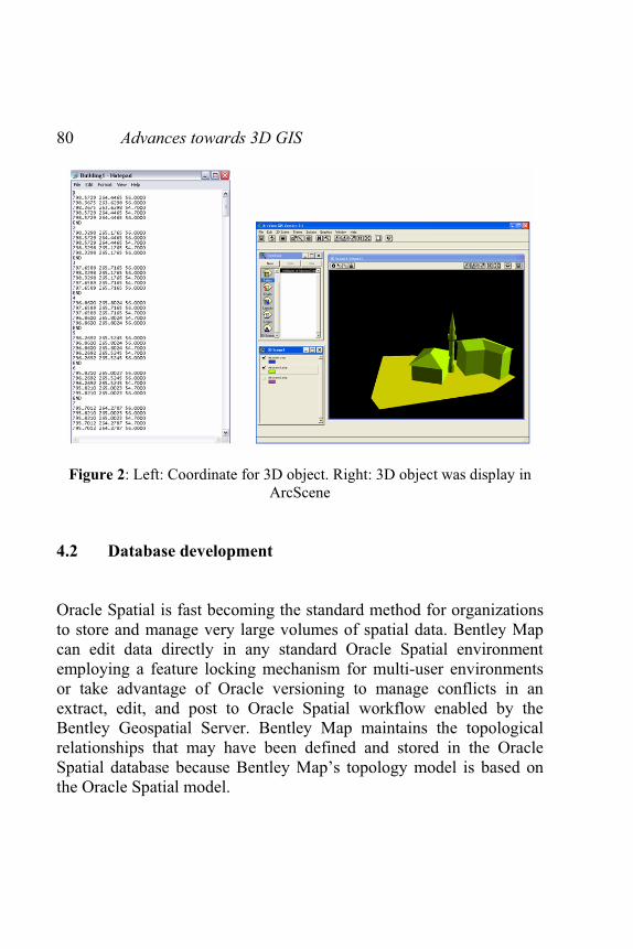
The constructed 3D models provide a series of 3D coordinates of the 3D objects of which will be used to generate series of nodes for database development purposes, see Figure 2 for the generated list of nodes and here the ArcGIS is for display testing purposes only.
4.1 Generation of 3D objects
80 Advances towards 3D GIS
Figure 2: Left: Coordinate for 3D object. Right: 3D object was display in ArcScene
4.2 Database development
Oracle Spatial is fast becoming the standard method for organizations to store and manage very large volumes of spatial data. Bentley Map can edit data directly in any standard Oracle Spatial environment employing a feature locking mechanism for multi-user environments or take advantage of Oracle versioning to manage conflicts in an extract, edit, and post to Oracle Spatial workflow enabled by the Bentley Geospatial Server. Bentley Map maintains the topological relationships that may have been defined and stored in the Oracle Spatial database because Bentley Map’s topology model is based on the Oracle Spatial model.

Managing 3D Spacial Objects using GeoDBMS and Microstation Geographics 81
Table 1: The structure of the object in Oracle Spatial
Despite the 2D geometry types, 3D coordinates can be maintained. For example, the five parameters of the geometry object for a 3D polygon with four vertices v(X, Y, Z), i.e. v1 (10, 10, 0), v2 (11, 9, 1), v3 (11, 12, 0) and v4 (9, 11, 1) will have the following values: SDO_GTYPE = 3003. The first 3 indicates three-dimensional object and the second 3 indicates a polygon.
SDO_SRID = NULL. The coordinate system is not specified, i.e. decoded in the coordinates SDO_POINT = NULL. The described type is polygon and therefore the value is NULL. SDL_ELEM_INFO = (1, 1003, 1). The first 1 in the sequence 1, 1003, 1 gives details about the geometry type (i.e. a simple polygon connected by straight lines). 1003 indicates that the polygon is an exterior ring. The final 1 specifies the geometry type, i.e. polygon. Furthermore, these particular values certify that the polygon does not contain holes. SDO_ORDINATES = (10, 10, 0, 11, 9, 1, 11, 12, 0, 9, 11, 1, 10, 10, 0).
4.3 Integrated 3D object and database

82 Advances towards 3D GIS
Microstation is the most powerful mapping and design environment available today. Bentley Map is directly integrated with MicroStation and takes advantage of its powerful capture, editing, display, and output capabilities. Bentley Map capitalizes on this knowledge and adds geospatial modeling and interoperability tools while preserving MicroStation performance and operation. Bentley Map includes new tools to improve interoperability with other GIS formats. Directly reference ESRI SHP files, MapInfo TAB files, Oracle Spatial features and others, or export dataset into these formats for sharing with other project.
Topology can be created on the fly or “on-demand” in Bentley Map. Topological relationships are stored in the DGN file according to the same model employed by Oracle Spatial. This allows complex analysis operations to occur quickly and maintains compatibility with Oracle Spatial for organizations that choose to use Bentley Map as an editing application for Oracle Spatial. Figure 3 shows the 3D dataset in .shp file was exported to Microstation Bentley Map and integrated with Oracle spatial. Figure 4 shows the query of objects, and Figure 5 shows the 2D terrain objects draped with the 3D objects.
4.3 Integrated 3D object and database

Managing 3D Spacial Objects using GeoDBMS and Microstation Geographics 83
Figure 3: Microstation Bentley Map: Left) 3D model was upload and save as .dgn file. Right) Integrated between Microstation and Oracle Spatial.
Figure 4: Microstation Bentley Map query. Left) Query of objects - shown in yellow color. Right) Query result

84 Advances towards 3D GIS
Figure 5: Left) 2D terrain objects. Right) 3D objects draped on the terrain.
5.0 CONCLUDING REMARKS
In this paper we have discussed how to manage 3D spatial objects with Microstation Bentley Map couple with Oracle Spatial 10g and also exhibited valuable information related to 3D functionality currently offered. The work also revealed that the operations needed to access and manipulate spatial data are still not transparent, standardized and user friendly. The user is expected to have excellent skills in both systems, i.e. understanding the conceptual representation in Bentley Map and being aware of the implementation in relational tables in Oracle Spatial 10g. It is an ongoing project and we expect to extend the work especially on spatial data modelling for 3D objects and see the research potential to the fullest.
REFERENCES
Batty M, Chapman D, Evans S, Haklay Mi, Kueppers S, Shiode N, Smith A, Torrens P, M, 2000, Visualizing the city: Communicating Urban Design to Planners and Decision-Makers, ISSN: 1467-1298, CASA, UCL, http://www.casa.ucl.ac.uk/visualcities.pdf.
Batty M, Dodge M, Jiang B, Smith A, 1998, GIS and Urban Design, ISSN:1467-1298 CASA, UCL, http://www.casa.ucl.ac.uk/urbandesifinal.pdf.
Brenner C., Haala N., and Fritsch D., 2001. Towards fully automated 3D city model generation. In Proc. Workshop on Automatic
Managing 3D Spacial Objects using GeoDBMS and Microstation Geographics 85
Extraction of Man-Made Objects from Aerial and Space Images III, Ascona.
De La Losa, 1998, Toward a 3D GIS: Conception of a 3D GIS with a complete topological management, In: Proceedings of GIS PlaNET’98 Conference, Lisbon, Portugal
ESRI, 1997, Using ArcView 3D Analyst. ESRI Publication, Redlands, California, USA, 118. p.
Microstation Bentley Map, http://www.bentley.com/en-US/Products/Bentley+MapOosterom, P. v, J. Stoter, W. Quak and S. Zlatanova, 2002, The
balance between geometry and topology, In: Proceedings of Spatial Data Handling, 8-12 July, Ottawa, Canada (to be published)
Varshosaz M., 2003. True Realistic 3d Models Of Buildings In Urban Areas, International Archives of the Photogrammetry, Remote Sensing and Spatial Information Sciences, Vol. XXXIV-5/W10.
Stoter, J. and P. van Oosterom, 2002, Incorporating 3D geoobjects into a 2D geo-DBMS, Proceedings of SPRS/ACSM, 19-26 April, 2002, Washington, USA, (to be published)
Siyka Zlatanova, Alias Abdul Rahman, Morakot Pilouk, 2003, 3D GIS: Current Status and Perspectives, ISPRS and CGI (Canadian Geomatic Institution) Conference, Ottawa, Canada.
Zlatanova, S., 2000, 3D GIS for urban development, PhD thesis, ITC, The Netherlands, 222 p.