4 Leggett Way, Sorrento - Heritage - Heritage · LOVELL CH EN 1 1.0 Introduction The subject...
15
Siobhan Blewitt & Chris Hanson 4 Leggett Way, Sorrento Heritage Impact Statement Included in VHR H1050 Collins Settlement Site 2700-3148 Point Nepean Road, Sorrento September 2017 Prepared by Prepared for
Transcript of 4 Leggett Way, Sorrento - Heritage - Heritage · LOVELL CH EN 1 1.0 Introduction The subject...
Sio b ha n B lew it t & C hr i s H an son
4 Leggett Way, Sorrento
Heritage Impact Statement
Included in VHR H1050
Collins Settlement Site
2700-3148 Point Nepean Road, Sorrento
September 2017
Prepared by Prepared for
L O V E L L C H E N 1
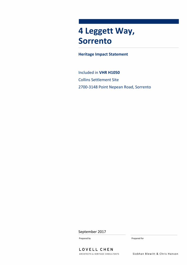
1.0 Introduction
The subject property at 4 Leggett Way, Sorrento, forms part of an historical area on the coast of Port
Phillip Bay known as the ‘Collins Settlement Site’. The area in question was the site of the first (albeit
short-lived) European settlement in Victoria, established in 1803 by the British Government. A number
of private residences are located within the Collins Settlement Site, which also includes a reserve area
(public land) managed today by Parks Victoria. The Collins Settlement Site includes all of the land
located at 2700-3148 Point Nepean Road, and is included in the Victorian Heritage Register (designated
H1050) as a site of historical, archaeological, aesthetic and social significance.
This heritage impact statement (HIS) has been prepared for Siobhan Blewitt and Chris Hanson to
accompany a permit application to Heritage Victoria for the proposed redevelopment of 4 Leggett Way,
Sorrento. The proposal involves demolition of the existing residence and construction of a new single
and two-storey residence with a swimming pool and associated landscaping. Planning approval for the
proposed residence will be sought separately under the provisions of the Mornington Peninsula
Planning Scheme.
Reference is made in this report to the following documentation:
• Architectural drawings prepared by InArc Architects, numbered 1.01 – 1.08 (inclusive, Revision
TP2 and TP3) and dated July, August and September 2017
• Landscape Design prepared by Robert Boyle and dated August 2017
Figure 1 Location plan showing the approximate location of the subject property at 4 Leggett Way,
Sorrento, indicated by red arrow
Source: www.street-directory.com

L O V E L L C H E N 2
1.1 Recent approvals
A permit exemption for the removal of 10 trees from within the subject property was issued by Heritage
Victoria on 29 May 2017. This tree removal has been completed.
Subsequently, Heritage Permit P27213 was issued by Heritage Victoria on 1 August 2017 for
‘archaeological testing, as part of a Cultural Heritage Management Plan process, at the 4 Leggett Way
property.’
The archaeological testing, undertaken on 22 August 2017 and comprising two 1x1 metre test pits and
three 0.5x0.5 metre test pits, was primarily designed to assess the Aboriginal cultural heritage sensitivity
of the subject property to inform the preparation of a voluntary Cultural Heritage Management Plan
(CHMP 14842) being undertaken prior to the proposed redevelopment of the site which is the subject of
the current permit application. As the construction activity associated with the proposed
redevelopment will result in substantial sub-surface disturbance, the archaeological investigations were
also located to minimise the potential for significant remains to be disturbed in the proposed
redevelopment works.
No historical archaeological deposits associated with the Collins Settlement or later occupation of the
site were identified in the archaeological investigations. Aboriginal cultural heritage material, in the
form of shell middens, were identified in all of the test pits, indicating that the shell midden site extends
across the entire property. These results will be documented in the CHMP for the property.
1.2 Heritage Controls and Listings
The area known as the ‘Collins Settlement Site’, of which the subject property forms a part, is of
recognised historic value as the first European settlement site in Victoria. The broader settlement site is
accordingly included in several heritage registers as set out below.
1.2.1 Victorian Heritage Register
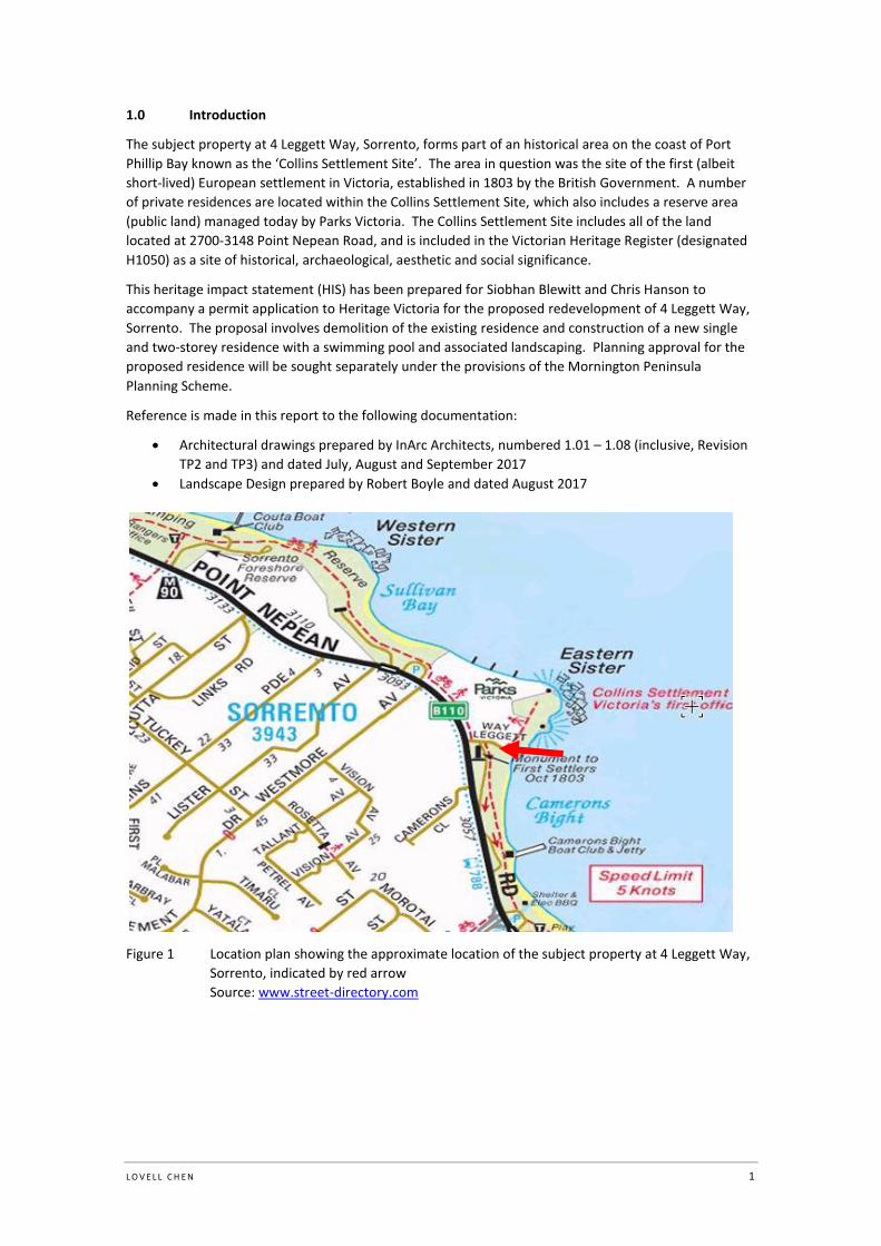
The ‘Collins Settlement Site’, 2700-3148 Point Nepean Road (including the subject property at 4 Leggett
Way) is included in the Victorian Heritage Register to the extent of all the land and water (marked L1)
bounded by the Point Nepean Road to the south, Camerons Bight jetty to the east, the edge of the
Sorrento Sailing Club land to the west and a line 50 metres out from high water mark to the north, as
well as all the features (marked F1), being the structures and works known as 'Settlers Graves' (Figure
2). The statement of significance outlines the historic, archaeological, aesthetic (landscape) and social
significance of the site.
Designated as H1050, an archaeological place and heritage place, the registration includes the so called
‘Seat of Government’ on the summit of the Eastern Sister, and the Settlers’ Graves on the Eastern Sister
headland.1 The settlement site also includes a monument, lookout and visitor centre.
What is significant?
The British Government's decision to establish a settlement in southern Australia
appears to have been prompted by favourable reports of Port Phillip Bay and
concerns about the interest of the French in the area. The colonising party
despatched from England comprised military personnel, administrative staff, a few
free settlers and a majority of convicts. Some were fortunate enough to be
accompanied by wives and children. Lt-Governor Collins led the party of 467
persons.
1 The four burials are believed to be associated with later settlers in the area and although marked by simple wooden
crosses, the locations are thought to be symbolic rather than accurately recording the burials.

L O V E L L C H E N 3
The site selected for the settlement was on the southern side of Port Phillip Bay at
Sullivan Bay, relatively close to the Heads, a site chosen to enable protection of
Bass Strait from the French. It was a difficult site to settle, without easy access to
fresh running water, an anchorage well off-shore, and poor soils for agriculture;
their survey of Port Phillip Bay revealed that much of the area had similar
characteristics.
The settlement was established on an area of land between the Western Sister and
Eastern Sister, prominent headlands which mark each end of Sullivan Bay. Most of
the settlement was close to the Eastern Sister. Initially a tent encampment, work
commenced quickly on building a jetty and other timber structures, including huts.
A Local limestone was apparently used to construct chimneys for the huts, and for
the building of the magazine. As well as barrels set into sand to trap fresh water,
wells were dug, as were privies. Land was cleared for the growing of crops, perhaps
totalling several acres.
In choosing this place for a settlement, the settlers directly displaced Aboriginal
people from a regular camping area.
In 1804 Collins decided to move the settlement to Van Diemens Land, where John
Bowen had established a settlement at Risdon Cove in 1803. They were moved as
two parties, the second group leaving on 20 May, just over seven months after the
settlement had been established.
Surviving physical evidence of the settlement is limited to oak barrels recovered in
1926, and artefacts thought to date to the initial settlement of the area such as the
remains of a hand blown brandy bottle inscribed "Old Cognac 1795" and a pair of
leg irons.
The graves site located within the Collins Settlement Historic Reserve is important
for symbolic reasons in long being recognised by both the government and the
community as a symbol and icon of the first attempt of European settlement in
Victoria (even though historical knowledge suggests they are unlikely to be
associated with the 1803-4 settlement).
How is it significant?
Collins Settlement Site is of historic, archaeological, aesthetic (landscape) and social
significance to the State of Victoria.
Why is it significant?
Collins Settlement Site is historically significant as the site of the British
Government's first official settlement in southern Australia, in 1803. From the
perspectives of global colonisation, the site contains historical fabric, associations
and meanings that are vital to the understanding of the history of colonisation in
southern Australia.
The site is one of few Australian 'founding' sites that have survived two centuries of
change. Like The Rocks in Sydney and Risdon Cove in Tasmania, the landscape of
Sullivan Bay has revealed evidence from its founding period. More evidence may
survive to be revealed as a result of future investigations.
Collins Settlement Site has aesthetic significance due to the survival of much of the
pre-settlement landscape of Sullivan Bay, including the enclosing headlands, the
old growth Moonah woodland, the shallow waters of the bay, the views between
the Eastern and Western Sister and the Western Sister and St Paul's, and to Arthurs
Seat.
L O V E L L C H E N 4
Collins Settlement Site has archaeological significance due to its potential to
contain relics relating to the historic occupation of the site.
Collins Settlement Site has social significance for long being recognised as the site
of the 1803 settlement. The Melbourne and Peninsula communities have strongly
defended the site during times when its long term protection seemed in jeopardy.
Figure 2 VHR extent of registration of the Collins Settlement Site (the location of the subject
property is indicated)
Source: Heritage Victoria
1.2.2 Victorian Heritage Inventory
The ‘Collins Settlement Site’, Point Nepean Road Sorrento, is also included in the Victorian Heritage
Inventory as H7821-0001.
The Inventory Significance of the Collins Settlement site is as follows:
Archaeological potential for subsurface remains of some structures although
development and subdivision would have destroyed most evidence.
Historical significance as a contact settlement site.
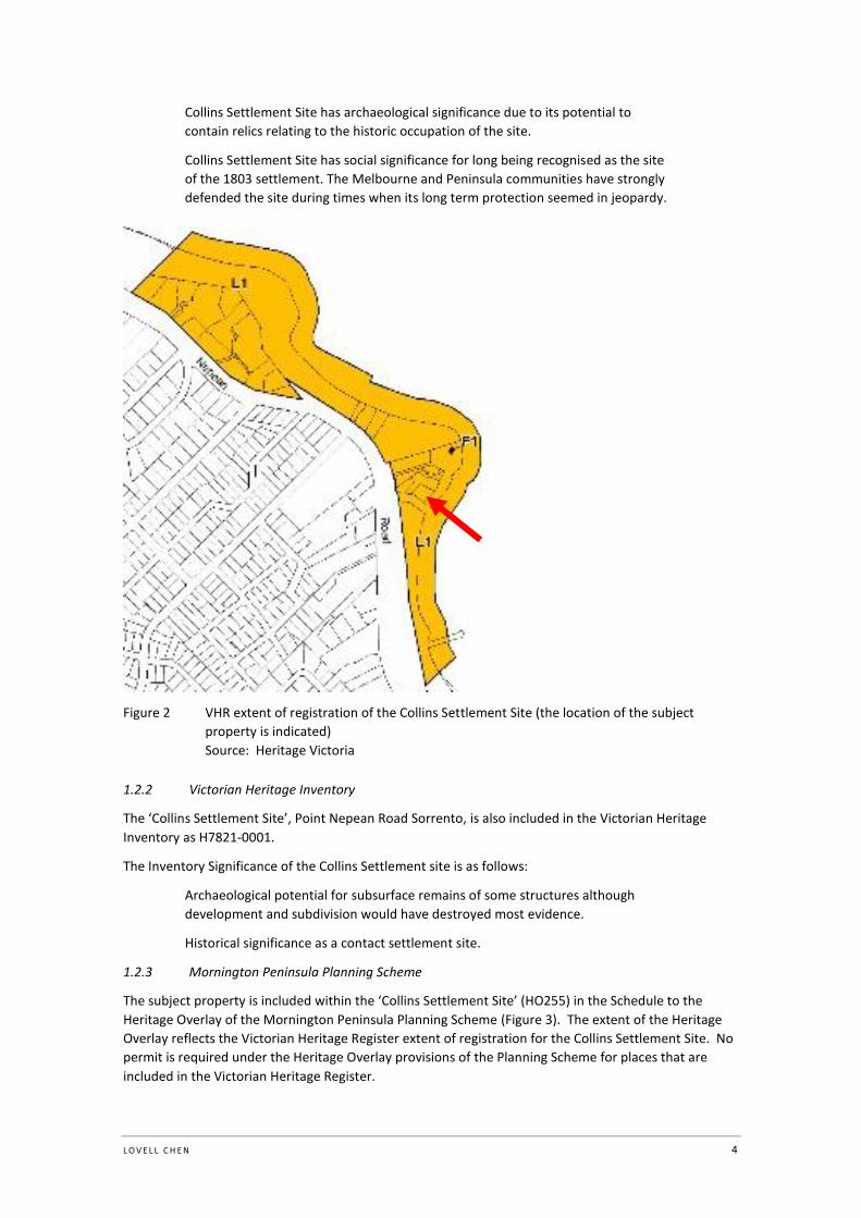
1.2.3 Mornington Peninsula Planning Scheme
The subject property is included within the ‘Collins Settlement Site’ (HO255) in the Schedule to the
Heritage Overlay of the Mornington Peninsula Planning Scheme (Figure 3). The extent of the Heritage
Overlay reflects the Victorian Heritage Register extent of registration for the Collins Settlement Site. No
permit is required under the Heritage Overlay provisions of the Planning Scheme for places that are
included in the Victorian Heritage Register.
L O V E L L C H E N 5
Figure 3 Heritage Overlay map showing the Collins Settlement Site (HO255); the location of the
subject property is indicated
Source: Mornington Peninsula Shire Planning Scheme
1.2.4 Other listings
National Trust Register
The ‘Collins Settlement Site ‘and ‘Sorrento Graves’ are also classified by the National Trust of Australia
(Victoria) (File Numbers L10051 and B2168 respectively). There are no statutory requirements or
constraints as a result of this listing.
National Heritage List
A nomination has also been made to the National Heritage List for the ‘1803 Collins Settlement Site’.
However, this nomination has been deemed ineligible for consideration by the Australian Heritage
Council because it has been considered in two consecutive annual assessment work plans (also known
as the ‘priority assessment list’) and not included on the NHL. However a nominated place ruled
ineligible in this way can be re-nominated, thereupon becoming eligible again for consideration.
Shire of Flinders Heritage Study
The Shire of Flinders Heritage Study – Inventory of Significant Places was prepared by Context Pty Ltd in
December 1992 and updated in June 1997. It recognises the Collins Settlement Site as a site of National
or State significance.
2.0 Description
The property is a generally rectangular allotment located on the south side of the Eastern Sister, east of
Point Nepean Road (Figure 4). The property comprises a simple two-storey brick dwelling with a
corrugated iron clad multi-pitched roof. The dwelling features a garage and open arched entries on the
north-west elevation and a first floor entry and timber balcony along the full extent of the south-east
elevation (Figure 5 - Figure 6). An elevated, stepped brick-lined garden bed extends along the west
property boundary, with a mature tree and smaller plantings along the east and south boundaries
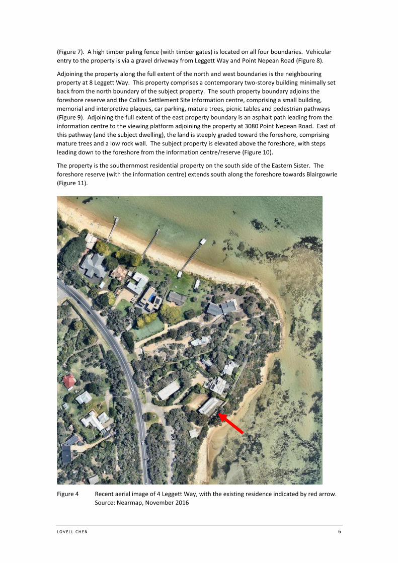
L O V E L L C H E N 6
(Figure 7). A high timber paling fence (with timber gates) is located on all four boundaries. Vehicular
entry to the property is via a gravel driveway from Leggett Way and Point Nepean Road (Figure 8).
Adjoining the property along the full extent of the north and west boundaries is the neighbouring
property at 8 Leggett Way. This property comprises a contemporary two-storey building minimally set
back from the north boundary of the subject property. The south property boundary adjoins the
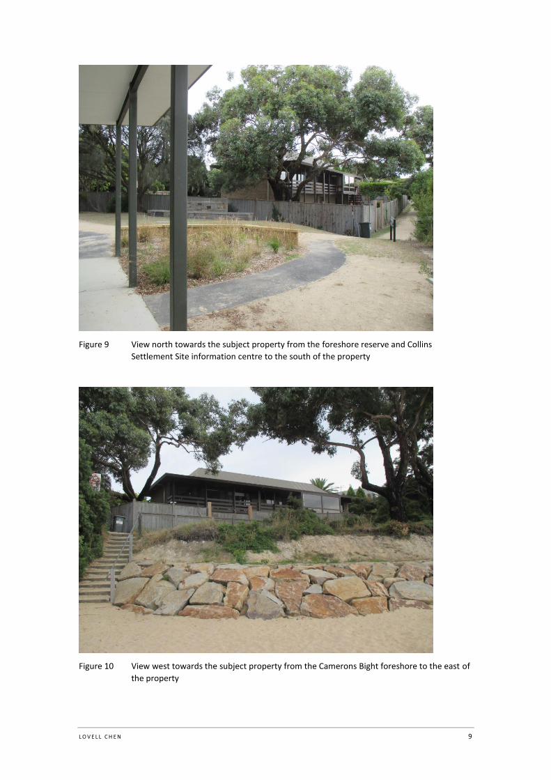
foreshore reserve and the Collins Settlement Site information centre, comprising a small building,
memorial and interpretive plaques, car parking, mature trees, picnic tables and pedestrian pathways
(Figure 9). Adjoining the full extent of the east property boundary is an asphalt path leading from the
information centre to the viewing platform adjoining the property at 3080 Point Nepean Road. East of
this pathway (and the subject dwelling), the land is steeply graded toward the foreshore, comprising
mature trees and a low rock wall. The subject property is elevated above the foreshore, with steps
leading down to the foreshore from the information centre/reserve (Figure 10).
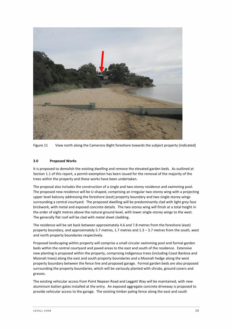
The property is the southernmost residential property on the south side of the Eastern Sister. The
foreshore reserve (with the information centre) extends south along the foreshore towards Blairgowrie
(Figure 11).
Figure 4 Recent aerial image of 4 Leggett Way, with the existing residence indicated by red arrow.
Source: Nearmap, November 2016

L O V E L L C H E N 7
Figure 5 North-west elevation of the existing residence and gravel driveway entry
Figure 6 South-east elevation of the existing residence and garden area

L O V E L L C H E N 8
Figure 7 Elevated garden bed along the west property boundary and gravel driveway – the trees
have been removed within this garden bed
Figure 8 View east along Leggett Way towards the subject property
L O V E L L C H E N 9
Figure 9 View north towards the subject property from the foreshore reserve and Collins
Settlement Site information centre to the south of the property
Figure 10 View west towards the subject property from the Camerons Bight foreshore to the east of
the property
L O V E L L C H E N 1 0
Figure 11 View north along the Camerons Bight foreshore towards the subject property (indicated)
3.0 Proposed Works
It is proposed to demolish the existing dwelling and remove the elevated garden beds. As outlined at
Section 1.1 of this report, a permit exemption has been issued for the removal of the majority of the
trees within the property and these works have been undertaken.
The proposal also includes the construction of a single and two-storey residence and swimming pool.
The proposed new residence will be U-shaped, comprising an irregular two-storey wing with a projecting
upper level balcony addressing the foreshore (east) property boundary and two single-storey wings
surrounding a central courtyard. The proposed dwelling will be predominantly clad with light grey face
brickwork, with metal and exposed concrete details. The two-storey wing will finish at a total height in
the order of eight metres above the natural ground level, with lower single-storey wings to the west.
The generally flat roof will be clad with metal sheet cladding.
The residence will be set back between approximately 4.6 and 7.8 metres from the foreshore (east)
property boundary, and approximately 5.7 metres, 1.7 metres and 1.3 – 3.7 metres from the south, west
and north property boundaries respectively.
Proposed landscaping within property will comprise a small circular swimming pool and formal garden
beds within the central courtyard and paved areas to the east and south of the residence. Extensive
new planting is proposed within the property, comprising indigenous trees (including Coast Banksia and
Moonah trees) along the east and south property boundaries and a Moonah hedge along the west
property boundary between the fence line and proposed garage. Formal garden beds are also proposed
surrounding the property boundaries, which will be variously planted with shrubs, ground covers and
grasses.
The existing vehicular access from Point Nepean Road and Leggett Way will be maintained, with new
aluminium batten gates installed at the entry. An exposed aggregate concrete driveway is proposed to
provide vehicular access to the garage. The existing timber paling fence along the east and south

L O V E L L C H E N 1 1
property boundaries will be retained, while the fence along the west boundary will be removed and
replaced with a new timber paling fence of 2.1 metres, matching the height of the existing fence. To the
north property boundary, the existing fence will be removed and replaced with a concrete sleeper
retaining wall and timber paling fence above to a height of 2.4 metres, matching the height of the
existing fence.
4.0 Assessment of Heritage Impacts
4.1 Assessment against VHR statement of significance
The Victorian Heritage Register statement of significance for the Collins Settlement Site identifies the
historical, archaeological, aesthetic and social heritage values which contribute to the significance of the
site. The proposal is assessed against each of these values below:
4.1.1 Historical values
Excerpt from VHR statement
Collins Settlement Site is historically significant as the site of the British
Government's first official settlement in southern Australia, in 1803. From the
perspectives of global colonisation, the site contains historical fabric, associations
and meanings that are vital to the understanding of the history of colonisation in
southern Australia.
The site is one of few Australian 'founding' sites that have survived two centuries of
change. Like The Rocks in Sydney and Risdon Cove in Tasmania, the landscape of
Sullivan Bay has revealed evidence from its founding period. More evidence may
survive to be revealed as a result of future investigations.
There will be no impact on the historical significance of the Collins Settlement Site from the proposed
works. The replacement of an existing private residence with a new residence will minimally alter the
presentation of visible development on the south side of the Eastern Sister but the historical
associations of the place with the early Collins settlement will be unchanged. The new works will be
wholly contained within the subject property and there will be no adverse impact on the foreshore
reserve and the Collins Settlement Site information centre to the south of the property.
4.1.2 Archaeological values
The archaeological significance of the Collins Settlement Site has been well documented, being
recognised from as early as the late nineteenth and early twentieth centuries. As noted in the VHR
Permit Policy for the Collins Settlement Site, any evidence which remains of the settlement is likely to be
below the ground surface, and could take the form of artefacts or artefact deposits, including glass,
ceramics, bone or other organic materials and metal. Recent archaeological investigations within the
Collins Settlement Site extent of registration confirm that subsurface evidence of both European
settlement and Aboriginal activity are present within the site. The following assessment of the proposal
has been prepared in consideration of the management recommendations contained in the Victorian
Heritage Register Permit Policy, the 2002 1803 Collins Settlement Site: Future Directions Management
Plan and the findings of recent subsurface testing within the subject property by Andrew Long &
Associates.
Excerpt from VHR statement
Collins Settlement Site has archaeological significance due to its potential to
contain relics relating to the historic occupation of the site.
VHR Permit Policy
The VHR Permit Policy for the Collins Settlement Site notes that the land and water of Sullivan Bay is a
significant place and the primary area of significance (i.e. generally contained within the registered land)

L O V E L L C H E N 1 2
has the highest potential of revealing archaeological evidence associated with past occupation. The
policy broadly outlines the potential of the site with regard to both Aboriginal and historic remains and
includes an assessment of the archaeological potential of the various settlement site structures and
features that were located on the site as well as the miscellaneous artefact scatters which may be
located within the registered land. The results of the archaeological testing within the property
undertaken to date are addressed below, with recommendations for further archaeological testing
within the proposed building footprint.
1803 Collins Settlement Site: Future Directions Management Plan
The 2002 1803 Collins Settlement Site: Future Directions Management Plan covers the broader area of
land along the Sorrento foreshore including Sullivan Bay, the Eastern and Western Sisters and a part of
Cameron’s Bight, and outlines a number of conservation policies which apply to both public and private
land. The Management Plan notes that ‘the whole of the area occupied by the 1803-4 Collins
settlement has the potential to retain archaeological evidence of the settlement’2, and contains a
number of heritage recommendations with regard to the development of the Collins Settlement site.
With specific regard to the archaeological potential of the Collins Settlement site, the Management Plan
notes that ‘all development and change needs to occur in such a way that any archaeological evidence
can be identified and recovered’3, and recommends archaeological investigation and/or monitoring
where any proposed development of the site will result in ground disturbance. The primary objective of
the policies guiding the management of the archaeological resources is preservation in-situ, and
protection of areas likely to contain archaeological resources.
Findings of subsurface testing
As outlined in Section 1.1, recent archaeological testing was undertaken within the subject property by
Andrew Long & Associates, pursuant to Permit No. P27213. While this testing was undertaken primarily
for Cultural Heritage Management Plan 14842 under the Aboriginal Heritage Act, an assessment of the
potential for remains associated with the Collins Settlement or later occupation of the site was also
undertaken. No historical archaeological remains were identified in the archaeological investigations
undertaken within the site.
With regard to Aboriginal cultural heritage, the testing identified cultural heritage materials, in the form
of shell midden deposits, in all of the excavations indicating that the shell midden extends across the
entire property.4
Response
Consistent with the management recommendations for land within the Collins Settlement Site included
in the 2002 Management Plan, the historical and Aboriginal archaeological potential within the subject
property has been addressed through the archaeological investigations undertaken to date and the
provision for monitoring of future ground disturbing works.
With specific regard to historical archaeology, it is noted that no historical remains have yet been
located within the property. In order to satisfactorily address the archaeological potential of the subject
property within the broader registered place, all excavation/ground disturbing activities associated with
the proposed residential development will be monitored by a qualified archaeologist. If any significant
historical archaeological deposits are uncovered during this testing, all works on site will cease and
Heritage Victoria will be contacted immediately.
2 Context, 1803 Collins Settlement Site: Future Directions Management Plan, Final report 2002, p. 17.
3 Context, 1803 Collins Settlement Site: Future Directions Management Plan, Final report 2002, p. 17.
4 Pers. Corresp. Zak Jones, Andrew Long & Associates, dated 23 August 2017.
L O V E L L C H E N 1 3
Aboriginal cultural heritage values within the property will be addressed with Aboriginal Victoria
through the preparation of CHMP 14842.
4.1.3 Aesthetic values
Excerpt from VHR statement
Collins Settlement Site has aesthetic significance due to the survival of much of the
pre-settlement landscape of Sullivan Bay, including the enclosing headlands, the
old growth Moonah woodland, the shallow waters of the bay, the views between
the Eastern and Western Sister and the Western Sister and St Paul's, and to Arthurs
Seat.
As documented in the VHR statement of significance, the aesthetic significance of the Collins Settlement
Site relates to the survival of much of the pre-settlement landscape of Sullivan Bay, the old growth
Moonah woodland and views, particularly between the Eastern and Western Sister. The landscape
setting of Sullivan Bay is key to the aesthetic significance of the Collins Settlement Site.
The subject property is a residential allotment adjacent to the foreshore and a public reserve within the
broader Collins Settlement Site. The property does not contribute to the aesthetic significance of the
Collins Settlement Site and the removal and replacement of the existing residence within the property
could occur without adverse impact on the identified aesthetic values and landscaped setting of the
heritage place. The critical issues with regard to the proposal in terms of aesthetic significance is the
potential impact on key views within the broader heritage place and the extent to which the proposed
new works will be visible and prominent in views towards the property.
In terms of the potential impact on key views within the Collins Settlement Site, the key views identified
as contributing to the significance of the registered place are the views between the Eastern and
Western Sisters. There will be no impact on these views from the proposed works due to the location of
the subject property on the south side of the Eastern Sister.
Where the subject property is visible in views to the north from and along the Camerons Bight foreshore
and from the reserve and Collins Settlement Site information centre to the south of the property, there
will be no adverse impact on these views from the proposed removal and replacement of the existing
residence with a new building of similar height and scale. The siting and form of the proposed new
dwelling has been carefully considered to capitalise on the location of the property adjoining the
foreshore, while recognising the aesthetic values and landscaped setting of the heritage place through
the use of materials which respond to and complement the surrounding landscape. The inclusion of
indigenous planting along the east and south property boundaries is appropriate within the context of
the broader setting and will serve to screen views to the new residence from the foreshore and public
reserve to the south of the property.
There will be no change to the presentation or existing vegetation within the reserve to the south of the
property. It is acknowledged that the proposed new residence will be visible from the public reserve
and in views to the reserve from the foreshore, but this is comparable with the existing residence and
will not impact on an appreciation of the reserve and foreshore as part of the broader Collins Settlement
Site.
4.1.4 Social values
Excerpt from VHR statement
Collins Settlement Site has social significance for long being recognised as the site
of the 1803 settlement. The Melbourne and Peninsula communities have strongly
defended the site during times when its long-term protection seemed in jeopardy.
L O V E L L C H E N 1 4
The subject property is part of the larger Collins Settlement Site which over time has undergone
development. The proposed works will not alter the social significance of the larger site and
importantly, will not impact on that area of the site which is reserved for public access (the foreshore
reserve and Collins Settlement Site information centre to the south).
5.0 Conclusion
The proposal involves the replacement of the existing residence within the subject property with a new
residence and associated landscape works. This proposal has been carefully considered and sensitively
developed in terms of architectural and landscape design, with the height, form and siting of the new
residence generally reflecting the existing, and materials and a colour palette which responds
appropriately to the broader landscape setting. In terms of the visual impacts, the proposed new
residence will not be overly prominent when viewed from the foreshore or public reserve and there will
be no impact on the valued qualities of the broader registered place.
In terms of archaeology, no historical material has been identified within the property through the
archaeological investigations undertaken to date. The historical archaeological significance of the site
has been appropriately managed through these investigations and recommendations for monitoring of
ground disturbing activities associated with the proposed development.
Overall the design and form of the proposed new residence and associated landscaping works is
appropriate within this site and the works are considered acceptable from a heritage perspective.