4 C OASTLINE MANAGEMENT OPTION CONSIDERATIONS
27
COASTLINE MANAGEMENT OPTION CONSIDERATIONS 4-1 G:\ADMIN\B16200.G.MJA\R.B16200.001.03.DOC 4 COASTLINE MANAGEMENT OPTION CONSIDERATIONS 4.1 Background 4.1.1.1 Beach Erosion Problem The shoreline is subject to a threat of erosion associated with: • short term storm events; and • long term recession as a result of a deficit in the overall sediment budget and the influences of climate change (sea level rise). Beach erosion is a natural process although it can and has been exacerbated in places by the influence of man. If erosion is allowed to occur naturally, the character and amenity of the beach are retained even where the shoreline is receding. Beach erosion becomes a problem when it threatens development, either causing loss or damage of the property or prompting construction of protective works such as seawalls. The essence of erosion problems is therefore not that beaches erode, but that development has occurred within the zone of natural beach movements. The designated Erosion Prone Area width of 140 metres established for Woorim by the EPA defines the potential future erosion within the next 50 years, although this is based on only limited information for this area. This comprises both the width likely to be threatened by erosion in the event of a major storm or series of storms and long-term progressive shoreline recession, taking into consideration likely sea level rise impacts. It contains a factor of safety (or uncertainty) of 1.4 on the expected erosion distances. Nevertheless, based on projection to the future of the recent past potential shoreline recession, the erosion prone width would be (order of) 100 metres along the northern part of Woorim and probably in excess of 140 metres towards Skirmish Point. This erosion potential would threaten all of Rickman Parade, most immediately at the southern end around First to Second Avenue and within about 15 –20 years at the northern end. As such, there is a need for comprehensive management action, as discussed below. 4.1.1.2 General Considerations Coastal issues requiring management action in the SEMP may be classified as: • coastal erosion (eg. beach loss, wind erosion of dunes, threat to adjacent development). • coastal land management and planning (eg, provision of access and recreational facilities, preservation of dune ecology, visual landscape management). For the SEMP, a key requirement is to preserve the beach as a recreational asset, with appropriate access and land management provisions. Woorim foreshore has substantial development, comprising predominantly residential properties along Rickman Parade and some public facilities at the township centre near the surf club. Rickman Parade represents the only feasible access road for the properties between Second and Fifth Avenues (Figure 3-14) and, in the absence of retreat of the development involving major
Transcript of 4 C OASTLINE MANAGEMENT OPTION CONSIDERATIONS

COASTLINE MANAGEMENT OPTION CONSIDERATIONS 4-1
G:\ADMIN\B16200.G.MJA\R.B16200.001.03.DOC
4 COASTLINE MANAGEMENT OPTION CONSIDERATIONS
4.1 Background
4.1.1.1 Beach Erosion Problem
The shoreline is subject to a threat of erosion associated with:
• short term storm events; and
• long term recession as a result of a deficit in the overall sediment budget and the influences of climate change (sea level rise).
Beach erosion is a natural process although it can and has been exacerbated in places by the influence of man. If erosion is allowed to occur naturally, the character and amenity of the beach are retained even where the shoreline is receding. Beach erosion becomes a problem when it threatens development, either causing loss or damage of the property or prompting construction of protective works such as seawalls. The essence of erosion problems is therefore not that beaches erode, but that development has occurred within the zone of natural beach movements.
The designated Erosion Prone Area width of 140 metres established for Woorim by the EPA defines the potential future erosion within the next 50 years, although this is based on only limited information for this area. This comprises both the width likely to be threatened by erosion in the event of a major storm or series of storms and long-term progressive shoreline recession, taking into consideration likely sea level rise impacts. It contains a factor of safety (or uncertainty) of 1.4 on the expected erosion distances. Nevertheless, based on projection to the future of the recent past potential shoreline recession, the erosion prone width would be (order of) 100 metres along the northern part of Woorim and probably in excess of 140 metres towards Skirmish Point.
This erosion potential would threaten all of Rickman Parade, most immediately at the southern end around First to Second Avenue and within about 15 –20 years at the northern end. As such, there is a need for comprehensive management action, as discussed below.
4.1.1.2 General Considerations
Coastal issues requiring management action in the SEMP may be classified as:
• coastal erosion (eg. beach loss, wind erosion of dunes, threat to adjacent development).
• coastal land management and planning (eg, provision of access and recreational facilities, preservation of dune ecology, visual landscape management).
For the SEMP, a key requirement is to preserve the beach as a recreational asset, with appropriate access and land management provisions.
Woorim foreshore has substantial development, comprising predominantly residential properties along Rickman Parade and some public facilities at the township centre near the surf club. Rickman Parade represents the only feasible access road for the properties between Second and Fifth Avenues (Figure 3-14) and, in the absence of retreat of the development involving major

COASTLINE MANAGEMENT OPTION CONSIDERATIONS 4-2
G:\ADMIN\B16200.G.MJA\R.B16200.001.03.DOC
resumptions, would need to be protected in the event of an erosion threat. As such, the practical dune buffer width available there at present varies from only about 5 -15m at Second Avenue to 30-35m at Fifth Avenue, substantially less than the erosion prone area width. Solutions to such problems where the beach and dune buffer width is inadequate and property is threatened by erosion generally involve engineering works and are almost invariably expensive.
4.2 Generic Option Considerations
A range of generic management options are available for consideration, which may be classified in terms of their consistency with natural coastal and environmental processes and the natural character and values of the coastline as follows:
“Soft” Options: Options which restore and/or preserve the natural character, behaviour and values of the coastal system. These will ensure the sustainable existence and natural character of the sandy beaches and dunes such that future erosion, both during short term storms and over the longer term, can be accommodated in a coastal buffer zone without threat to development requiring protective works.
Soft options may include works such as beach nourishment with sand or planning solutions that require development to be outside the zone of potential erosion (buffer zone), including:
• regulatory controls on building in undeveloped areas;
• removal of existing development from erosion prone land, and/or
• works aimed at restoration of the beach/dune system seaward of the development to provide an adequate buffer width to accommodate erosion.
“Hard” Options: Options that involve construction of works either to form a barrier to natural coastal erosion to protect development (seawalls) or to alter the natural processes to change the way in which the beach behaves (groynes and breakwaters).
Combinations of options or “hybrid” management approaches are often the most suitable where existing development lies within the erosion prone area. For example, works options such as terminal protection (seawalls) are sometimes combined with partial set-back of development, or may be augmented with ongoing beach nourishment to offset associated deleterious environmental and recreational amenity impacts. In addition, most options need to be supplemented with relevant amendments to local planning controls.
Thus, engineering works options for Woorim may include ‘soft’ or ‘hard’ solutions, or a combination of both. The most common feasible works options for overcoming beach erosion problems include the following and are discussed in more detail below:
• beach nourishment with sand to restore the beach and dune system;
• seawalls to protect property;
• groynes to control the longshore movements of sand; and
• offshore breakwaters or submerged reefs to modify wave processes which erode the beach.

COASTLINE MANAGEMENT OPTION CONSIDERATIONS 4-3
G:\ADMIN\B16200.G.MJA\R.B16200.001.03.DOC
Such works options are generally expensive, typically in the range $2000 to $5000 per metre length of beach to construct for adequate protection, and the ‘hard’ structural options typically have adverse side effects on the beach system. Ongoing maintenance requirements must be considered in both the design and financing. Experience indicates that careful design in full cognisance of the prevailing coastal and ocean processes and the short and longer term effects is essential for success and cost-effectiveness of such works.
For example, it is known that seawalls constructed on retreating shorelines may give protection to property, but will eventually cause loss of the adjacent beach. There is a need to ensure that the foundations of the seawall are sufficiently deep for stability to cater for the loss of the beach, typically requiring deeper foundations the more seaward the seawall is located. Similarly, beach nourishment must be designed and implemented to provide for the cross-shore and longshore movements of sand affecting the area for long term effectiveness in providing property protection while maintaining the recreational amenity of sandy beach systems.
4.3 Decision Matrix
It is convenient to consider beach protection options in the broad terms of the matrix illustrated in Table 4-1. This matrix, in effect, represents a decision tool based on criteria relating to:
• ‘natural’ versus ‘altered’ character; and
• ‘non-works’ (planning) versus ‘works’ options.
Table 4-1 Matrix of Beach System Management Options
Preserve Natural Beach System Character
Accept Change to Natural Beach System Character
Non-Works Options (planning, management and regulation)
Development free buffer zones via planning or land use regulation; Resumptions of erosion prone development; Set-back of buildings; Building guidelines and controls; Land use guidelines and controls; Management including dune care activities.
Accept development on vulnerable erosion prone land, but prevent any protection works (allow loss of buildings and facilities as erosion occurs).
Works Options Beach nourishment with sand to restore the beach and dune system; Submerged reefs for shore protection and/or surfing.
Seawalls to protect property; Groynes to control the longshore movements of sand; Offshore breakwaters to modify beach shape and sand transport.
To be consistent with coastal management policy guidelines and the priorities generally adopted by the community in areas where the beach amenity is important, the options in the column headed

COASTLINE MANAGEMENT OPTION CONSIDERATIONS 4-4
G:\ADMIN\B16200.G.MJA\R.B16200.001.03.DOC
‘Preserve Natural Beach System Character’ would normally have highest ranking in any assessment criteria. Consideration may also be given to other low cost temporary works options and hybrid options that combine the beneficial characteristics and offset deleterious characteristics of specific individual options.
The likelihood of success (or the risk of failure) is a key consideration in the selection of possible solution options. The options adopted involving expenditure of public funds should preferably be tried and proven techniques for dealing with beach erosion problems. There are a number of other (generally lower cost) options that are commonly put forward, covering a wide range of operational modes and with various claims of success. Most of these options typically have limited theoretical backing, have limited potential for providing significant long term benefits and/or have generally not been proven as an effective means of beach stabilisation. Such options would be ranked as low feasibility of success and would not be recommended for Woorim.
4.4 Options for Woorim
4.4.1 General Considerations
The need for and nature of solution options to deal with the coastal erosion problem at Woorim depends on the nature and level of the threat and consequences if it is left unchecked. The erosion problem to be addressed is jointly one of threat to property and loss of the beach, to varying degrees along the beach length. The most appropriate management options may vary along the section of beach.
It must be recognised that some options aimed primarily at protection of property located within the erosion prone area (eg seawall construction) may be detrimental to the beach. Further, some options that restore and/or maintain the beach (eg nourishment) provide a measure of protection to the property. Invariably, overcoming an existing problem of chronic beach loss or degradation is very costly.
140m EPA140m EPA
Figure 4-1 Development located in EPA erosion prone area

COASTLINE MANAGEMENT OPTION CONSIDERATIONS 4-5
G:\ADMIN\B16200.G.MJA\R.B16200.001.03.DOC
Considerations are set out below in the context of the nature of the erosion threat and the priority objective to be achieved.
4.4.1.1 Undeveloped Areas
In presently undeveloped areas to both the north and south of the main Woorim township, the key objective of the SEMP is to prevent an erosion problem from occurring in the future. That is, allowing the natural beach processes of erosion and accretion, including any progressive long term trend of shoreline retreat to occur.
Figure 4-2 Undeveloped dune buffer area north of Woorim development
The most appropriate coastal management strategy there is to prevent construction of development and facilities in the erosion prone area together with observational monitoring and dune management action as needed, in accordance with EPA guideleines. The natural processes, including shoreline fluctuations, will thus be allowed to continue unimpeded and the natural amenity and character of the beach and dune will be retained.
This may require a set-back control on any future development. To the extent that this is a natural receding coastline, the frontal dune system needs to continue to roll back with the shoreline and the set-back needs to provide for the future erosion. To achieve this, the following coastline management strategies would need to be adopted:
• Ensure appropriate planning controls are in place to prevent infrastructure and residential development occurring in erosion prone areas which are presently undeveloped (preferably over a 100 year planning timeframe);

COASTLINE MANAGEMENT OPTION CONSIDERATIONS 4-6
G:\ADMIN\B16200.G.MJA\R.B16200.001.03.DOC
• Allow natural processes to occur with ongoing monitoring of coastline behaviour;
• Continue dune management and protection works and controlled access to the shoreline as necessary to maintain the integrity of the dune system and prevent wind erosion.
4.4.1.2 Areas With Existing Development Under Long Term Erosion Threat
Where present development is not under immediate erosion threat but may potentially come under threat over time, forward planning is needed to prevent future problems. The degree of natural variability in the coastal processes and the level of uncertainty in predicting future coastline behaviour over long timeframes are such that the need for and nature of any future action will be dependent on factors that are unknown at present such as:
• realisation of the erosion threat and the likelihood of ongoing recession; and
• future opportunities and attitudes towards coastline management and options for dealing which such threat.
The potential future threat from erosion should, however, be recognised in present planning and appropriate strategies put in place that will not compromise future management decisions. It is therefore considered that in those areas where existing development may be threatened over the longer term, the following strategies be adopted:
• allow natural processes to occur with ongoing monitoring of coastline behaviour;
• set specific objectives and dates for review and update of the erosion prone area extent and management options on the basis of ongoing information;
• continue dune management and protection works as necessary to maintain the integrity of the dune system and prevent wind erosion;
• ensure appropriate planning controls are in place to prevent additional development or construction of facilities occurring and limit the intensification of existing development in the likely erosion prone areas (preferably over a 100 year planning timeframe).
4.4.1.3 Areas With Existing Development under Immediate or Short Term Erosion Threat
Based on past trends, residential properties, public facilities and roads at Woorim are likely to become under direct threat from erosion within the normal planning timeframe of 50 years. To the extent that there will be increasing sea level rise in the future, there will be an increased erosional trend at this beach.
The erosion problem thus manifests as follows:
• Beach amenity, access and safety are diminished;
• The natural character of the beach is diminished; and
• Development (residential property, roads, public facilities and access) would be threatened should the erosion progress as projected.
The key objectives are thus to improve the beach as a recreational facility of environmental, social and economic value to the community and to protect property and facilities. There are two basic

COASTLINE MANAGEMENT OPTION CONSIDERATIONS 4-7
G:\ADMIN\B16200.G.MJA\R.B16200.001.03.DOC
strategic approaches for dealing with the joint problems of erosion threat to the development and loss of the beach, namely:
• retreat from the erosion prone area and allow the natural erosion processes to occur; or
• hold the present coastal alignment by protection in one of a range of ways.
There are alternative approaches within these two categories, as discussed below.
Retreat Options
The intent of retreat options is to remove the development under threat and allow the beach and dune to behave in the natural manner, thus restoring and retaining the natural character and amenity of the beach as the shoreline recedes. The planned retreat option acknowledges that erosion is an ongoing natural phenomenon and seeks to address the issue by removal of threatened facilities rather than trying to protect them. This would release a quantity of sand into the active beach from the receding dune system and provide some additional space for the natural beach movements to occur.
At Woorim, there may be some scope for setting back (retreating) some facilities. However, as outlined above, this option is limited because of the extent of residential development that already is located within the erosion prone area and the importance of Rickman Parade as the only feasible access road for those properties.
Protection Options
Options to hold the present coastal alignment fall into two sub categories:
• Structural measures such as seawalls, groynes or offshore breakwaters/reefs to either directly protect the property or trap sand to rebuild the beach in front; and
• Beach nourishment to rebuild the beach with sand imported from outside the active beach system to make up the deficit, either alone or with other control structures to improve the longevity and give added protection.
Structural and nourishment protection options are discussed in detail below.
4.4.2 Structural Protection Options
Structural options provide protection of property against ongoing erosion either directly through the construction of a seawall or by rebuilding of the beach through the construction of groynes or offshore breakwaters. They are options that could be considered in the event that sufficient beach nourishment sand is not available and/or retreat options are not viable. However, there are always some adverse impacts of such an approach where no additional sand is provided, as outlined below.
Such structures would typically be of flexible rubble mound design with rock being sourced and trucked to the site from quarries in the region. More recently, less robust higher maintenance sand-filled geotextile bag units have been used effectively. While these structures may be effective in protecting property or providing a localized wider beach, they are generally accompanied by associated costs related to adverse impacts on the adjacent beaches. This cost is typically made up of direct costs associated with lost income from the tourist industry and other intangible costs

COASTLINE MANAGEMENT OPTION CONSIDERATIONS 4-8
G:\ADMIN\B16200.G.MJA\R.B16200.001.03.DOC
associated with the natural coastal amenity, beach access, loss of recreational beach area and degradation of ecological values.
4.4.2.1 Seawalls
Seawalls are robust structures constructed along the shoreline with the intent of providing terminal protection against ongoing recession. They are typically constructed of loosely placed rock to allow for some flexible movement and need to be designed to withstand severe wave attack. Seawalls should be continuous to prevent end effects and/or discontinuities that could threaten the overall integrity of the wall. They also have to be suitably founded for stability against scour at the toe of the structure, particularly on a receding shoreline.
While a properly designed and constructed seawall can protect the landward property from erosion, it effectively isolates the sand located behind the wall from the active beach system and leads to other adverse consequences. On a receding shoreline, in the absence of associated beach nourishment, the seawall becomes progressively further seaward on the beach profile over time. This leads to a gradual increase in the quantity of sand effectively lost from the beach system, with:
• lowering and eventual loss of the beach in front of the wall; and
• exacerbation of the erosion on the downdrift end of the wall where the losses are transferred and concentrated.
Scour and lowering of the beach in front of the wall ultimately exposes it to higher wave attack and can lead to slumping and the need for ongoing maintenance. Such maintenance is typically in the form of topping up of the wall with additional rock. However, where the seawall is not adequately designed or constructed, complete reconstruction may be needed.
Seawalls constructed in isolation without other beach improvement works such as nourishment can thus be effective in protecting the property behind, but at a cost of the loss of the beach in front and exacerbated erosion on the downdrift side.
Figure 4-3 Seawalls on eroding shorelines cause loss of usable beach
COASTLINE MANAGEMENT OPTION CONSIDERATIONS 4-9
G:\ADMIN\B16200.G.MJA\R.B16200.001.03.DOC
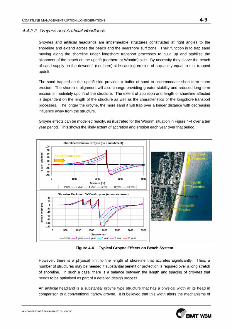
4.4.2.2 Groynes and Artificial Headlands
Groynes and artificial headlands are impermeable structures constructed at right angles to the shoreline and extend across the beach and the nearshore surf zone. Their function is to trap sand moving along the shoreline under longshore transport processes to build up and stabilise the alignment of the beach on the updrift (northern at Woorim) side. By necessity they starve the beach of sand supply on the downdrift (southern) side causing erosion of a quantity equal to that trapped updrift.
The sand trapped on the updrift side provides a buffer of sand to accommodate short term storm erosion. The shoreline alignment will also change providing greater stability and reduced long term erosion immediately updrift of the structure. The extent of accretion and length of shoreline affected is dependent on the length of the structure as well as the characteristics of the longshore transport processes. The longer the groyne, the more sand it will trap over a longer distance with decreasing influence away from the structure.
Groyne effects can be modelled readily, as illustrated for the Woorim situation in Figure 4-4 over a ten year period. This shows the likely extent of accretion and erosion each year over that period.
Shoreline Evolution: Groyne (no nourishment)
-60-40-20
020406080
100
0 1000 2000 3000 4000Distance (m)
Bea
ch W
idth
(m)
Initial 2 year 4 year 6 year 8 year 10 year
Sand Transport
Shoreline Evolution: Groyne (no nourishment)
-60-40-20
020406080
100
0 1000 2000 3000 4000Distance (m)
Bea
ch W
idth
(m)
Initial 2 year 4 year 6 year 8 year 10 year
Sand Transport
Shoreline Evolution: 3x30m Groynes (no nourishment)
-120-100-80-60-40-20
02040
0 500 1000 1500 2000 2500 3000 3500Distance (m)
Bea
ch W
idth
(m)
Initial 2 year 4 year 6 year 8 year 10 year
Shoreline Evolution: 3x30m Groynes (no nourishment)
-120-100-80-60-40-20
02040
0 500 1000 1500 2000 2500 3000 3500Distance (m)
Bea
ch W
idth
(m)
Initial 2 year 4 year 6 year 8 year 10 year
Figure 4-4 Typical Groyne Effects on Beach System
However, there is a physical limit to the length of shoreline that accretes significantly. Thus, a number of structures may be needed if substantial benefit or protection is required over a long stretch of shoreline. In such a case, there is a balance between the length and spacing of groynes that needs to be optimised as part of a detailed design process.
An artificial headland is a substantial groyne type structure that has a physical width at its head in comparison to a conventional narrow groyne. It is believed that this width alters the mechanisms of

COASTLINE MANAGEMENT OPTION CONSIDERATIONS 4-10
G:\ADMIN\B16200.G.MJA\R.B16200.001.03.DOC
sand transport past the end of the structure and may allow a wider/longer beach to be retained on the updrift side for the same protrusion offshore. This could have the benefit of minimising the need for, or maximising the spacing of, additional structures to provide protection for a long stretch of coastline. However, such headland type structures would be larger and more expensive to construct.
Groynes or artificial headlands can thus be used to rebuild a beach and stabilise the shoreline against ongoing recession on the updrift side. However, in the absence of other works such as beach nourishment, this comes at the cost of exacerbated erosion, additional to the existing recession trend, on the downdrift side to where the erosion trend is transferred.
Another significant consideration associated with groynes is their potential visual intrusion to the vista of a long sweeping beach and interruption to direct access along the beach. There are various design options with respect to the style and crest height of the structures that could be considered to minimise such adverse effects.
4.4.2.3 Offshore Breakwaters and Submerged Reefs
Offshore breakwaters and submerged reefs are robust structures constructed parallel to the shoreline offshore from the beach. Their function is to alter the height and direction of waves reaching the beach creating a sheltered zone in which sand moving along the coast under longshore transport processes is trapped and accretes forming a tombolo. In a similar fashion to groynes, this trapping effect starves the downdrift beaches of sand leading to erosion there.
Figure 4-5 Typical Offshore Breakwater Effects on Beach System
Offshore breakwaters are typically surface piercing structures that are capable of withstanding and blocking wave attack. The build up of sand and reduced wave heights provide protection against storm erosion and the stabilising effect can reduce long term recession rates behind and updrift of the structures. The extent of influence is dependent on the length, spacing and distance offshore and these would need to be considered in optimising the design of such structures. Construction of offshore breakwaters is also generally more difficult and expensive than shore connected structures.

COASTLINE MANAGEMENT OPTION CONSIDERATIONS 4-11
G:\ADMIN\B16200.G.MJA\R.B16200.001.03.DOC
Submerged artificial reefs are another form of offshore breakwater that could be considered. By their nature, submerged reefs allow the transmission of some wave energy and are therefore less effective in stabilising the beach unless they are of substantial size. Recently, there has been a popular trend toward combining this option with creation of artificial surfing breaks, with limited success.
Similar to groynes, offshore breakwaters and submerged reefs could be used to rebuild a beach and stabilise the shoreline against ongoing recession behind and on the updrift side, provided there is an adequate supply of sand. However, in the absence of other works such as beach nourishment, this comes at the cost of exacerbated erosion on the downdrift side, and sometimes on both sides. While such structures are typically expensive to construct, they offer the advantage of not interrupting access and the long sweeping vistas of the beach. Surface piercing structures will, however, interrupt views offshore. Submerged reefs do not have this impact but may be less effective in the level of protection (for similar sized structures). Surfing characteristics will also be affected by providing calmer conditions in the lee of the structures and potentially enhanced surfing waves in the vicinity of the structures (subject to careful research and design).
4.4.3 Beach Nourishment Options
The primary intent of beach nourishment is to ensure existence of the recreational beach and provide protection to the development by rebuilding the beach with sand imported from outside the active beach system. This effectively replaces the deficit of sand that is causing the erosion. In this way a natural beach and its associated values will be returned and maintained while providing a buffer of sand to accommodate natural beach fluctuations and protect the property and facilities behind.
The quantity of sand required will be dependent on the design philosophy with respect to the level of initial and ongoing protection and the use of structures to enhance the longevity of the works. Sufficient sand should ideally be provided to be able to accommodate short term storm erosion and a period of long term recession associated longshore sediment transport differentials and sea level rise.
Provision should be made for the placed sand to extend across the full beach profile as illustrated in Figure 4-6 to nourish depleted nearshore areas as well as the upper beach, the total quantity of sand being determined accordingly. If the sand is placed only on the upper visible portion of the beach, redistribution will quickly occur to establish an equilibrium profile giving the impression that the sand is ‘lost’ and the project is a failure. In such a case, the sand is, in fact, not ‘lost’ but remains in the active system providing an overall net gain commensurate with the quantity placed after cross-shore distribution.

COASTLINE MANAGEMENT OPTION CONSIDERATIONS 4-12
G:\ADMIN\B16200.G.MJA\R.B16200.001.03.DOC
Erosion Scarp / Seawall
MS
Existing Beach
NourishmentNourishment
Erosion Scarp / Seawall
MS
Existing Beach
NourishmentNourishment
Figure 4-6 Typical Beach Nourishment Profile
Dune construction and stabilisation works, including active management and protection of the fragile native dune vegetation to prevent sand loss due to wind erosion, usually needs to form part of any substantial beach nourishment scheme aimed at restoring the beach and dune system. In that case, it would incorporate design provisions to accommodate the effects of climate change including sea level rise. Where the aim of the nourishment is to re-establish a beach in front of an existing seawall without provision of a dune, the need for stabilisation works such as establishment of native dune vegetation (eg. Spinifex grass) would depend on the potential for wind erosion resulting from the works.
While beach nourishment may affect the ecological values of the beach and nearshore areas, it needs to be recognised that the nourishment sand would be placed in the active zone where the natural environment is one of substantial fluctuations and disturbances to which the ecological communities adapt naturally. Furthermore, the nourishment would effectively rebuild the beach and nearshore profile to where they once were. As such, while there may be some short term ecological impacts, in the longer term the environment will adapt and recolonise to behave as a natural beach system.
One of the inherent advantages of beach nourishment is that it maintains the natural character and recreational amenity of the beach while also providing property protection. As such, where the beach is severely depleted, it provides many intangible benefits to the general community, as well as a direct economic benefit to those businesses that rely on tourism and the presence of a usable beach.
However, identification and access to sources of suitable nourishment sand is usually a key issue, as is the cost, typically around $2,000-$5,000 per lineal metre of beach depending on the benefit gained, the sand source and method of placement. Transport of the sand to the beach is most cost-effectively achieved by dredging procedures. The use of trucks is typically slow and costly, with adverse impacts on the local community and road infrastructure.
There may be an ongoing cost to maintain this protection and amenity through future maintenance re-nourishment works in areas where the shoreline recession is progressive and/or future sea level rise will exacerbate the present problem. This needs to be assessed and provisions made in the initial design.

COASTLINE MANAGEMENT OPTION CONSIDERATIONS 4-13
G:\ADMIN\B16200.G.MJA\R.B16200.001.03.DOC
4.4.3.1 Nourishment Alone
Beach nourishment alone (ie. without accompanying control structures) is beneficial to the beach system, with no adverse erosion effects, as it introduces additional sand into the active beach system. The sand will gradually disperse to the adjacent beaches under the influence of the prevailing wave conditions. This process will provide a net benefit to those adjacent beaches but, unless topped up with ongoing maintenance nourishment, will gradually reduce the volume of sand and the available buffer in the zone initially nourished (Figure 4-7 top).
Accordingly, the design of any nourishment program must be undertaken carefully, recognizing that re-nourishment may be required from time to time to provide ongoing protection, particularly in an area experiencing long term recession, such as at Woorim (Figure 4-7 bottom). The quantity and frequency of such re-nourishment will be dependent on the initial design philosophy with respect to ongoing protection as well as the prevailing conditions that will be subject to natural variability.
The long term success of beach nourishment as a coastal protection option for Woorim is therefore dependent on the nature of the shoreline processes (ongoing recession or dynamically stable) and, potentially, ongoing availability of suitable sand and an ongoing commitment (including available funds) for re-nourishment should that be necessary.
Monitoring should be carried out following nourishment to determine its longer term trend of behaviour, allowing for short term fluctuations associated with storm erosion and subsequent natural beach accretion. This would provide essential information for any future decisions on coastal management at the site.
Shoreline Evolution: Initial Nourishment Only
0
20
40
60
0 1000 2000 3000 4000Distance (m)
Bea
ch W
idth
(m)
Initial1 year2 year3 year4 year
Shoreline Evolution: Nourishment with Maintenance
0
20
40
60
0 1000 2000 3000 4000Distance (m)
Bea
ch W
idth
(m)
Initial1 year2 year3 year4 year
Figure 4-7 Conceptual beach nourishment dispersion along the shoreline without maintenance nourishment (top) and with maintenance (bottom)

COASTLINE MANAGEMENT OPTION CONSIDERATIONS 4-14
G:\ADMIN\B16200.G.MJA\R.B16200.001.03.DOC
4.4.3.2 Nourishment with Control Structures
As discussed above, beach nourishment alone is subject to the gradual dispersion of sand to adjacent beaches and ongoing losses as part of long term recession trends. Such losses can be minimized with the use of control structures such as groynes or offshore breakwaters to help hold the sand where it is most needed. The structures will act to hold the sand and change the coastal alignment thereby stabilising the shoreline to a degree and potentially reducing long term recession rates.
While such structures will increase the longevity of the beach nourishment and the protection it provides in some parts of the beach, they can introduce adverse impacts to adjacent beaches, depending on the initial nourishment and re-nourishment strategy. Exacerbation of erosion on the downdrift (southern) side of control structures can be minimized by ensuring that the initial nourishment essentially ‘fills’ them and re-nourishment provides for the potential ongoing losses.
Due to the stabilizing effect of the structures, the ongoing overall losses in the nourishment area would be less. As such, the design life of a particular quantity of beach nourishment is may be increased compared to that without control structures. However, there would be the added cost and impacts of the structures.
On a beach with progressive sand loss and associated shoreline recession, erosion of the nourished beach with control structures will commence and be greatest at the updrift (northern) end of each benefited compartment and immediately downdrift of the structures. The rate of long term recession will reduce northwards towards the control structures and be effectively zero immediately updrift (north) of the control structures. As such there will be variations in the rate of recession and associated erosion threat along the shoreline, to be considered in the design of the works. If the desired beach improvement is to be maintained along the whole beach length, re-nourishment would be required from time to time.
Even if the structures are fully nourished initially and ongoing re-nourishment is carried out to replace the eroded sand, some (reduced) downdrift erosion would be likely due to the minimizing influences of the control structures locking up sand and transferring long term losses. Consideration could be given to either accepting this erosion in undeveloped areas or carrying out other mitigation works such as other control structures and/or the placement of additional nourishment sand to compensate. The quantity and frequency of re-nourishment in this case would therefore be dependent on the need to minimize adverse impacts to the south.

COASTLINE MANAGEMENT OPTION CONSIDERATIONS 4-15
G:\ADMIN\B16200.G.MJA\R.B16200.001.03.DOC
Shoreline Evolution: Nourishment + Groyne
-60
-40
-20
0
20
40
60
80
100
0 500 1000 1500 2000 2500 3000 3500 4000Distance (m)
Bea
ch W
idth
(m)
Initial1 year2 year3 year4 year
Shoreline Evolution: Nourishment + Groyne
-60
-40
-20
0
20
40
60
80
100
0 500 1000 1500 2000 2500 3000 3500 4000Distance (m)
Bea
ch W
idth
(m)
Initial1 year2 year3 year4 year
Shoreline Evolution: 3x30m Groynes + Initial Nourishment
-100-80-60-40-20
02040
0 500 1000 1500 2000 2500 3000 3500Distance (m)
Bea
ch W
idth
(m)
Initial 2 year 4 year 6 year 8 year 10 Year
Shoreline Evolution: 3x30m Groynes + Initial Nourishment
-100-80-60-40-20
02040
0 500 1000 1500 2000 2500 3000 3500Distance (m)
Bea
ch W
idth
(m)
Initial 2 year 4 year 6 year 8 year 10 Year
Figure 4-8 Conceptual shoreline response to groyne with nourishment maintenance to reduce downdrift erosion
4.4.3.3 Nourishment with Terminal Protection (Seawalls)
Appropriate planning, monitoring and management of a beach nourishment scheme would aim for timely re-nourishment to occur if and as needed to ensure that a suitable buffer is retained to accommodate storm erosion. However, there are often uncertainties associated with incomplete understanding of the likely future beach behaviour or feasibility of future re-nourishment such that there would be a risk that nourishment may not occur in the future and property behind could be threatened by erosion.
An option for dealing with this risk is to incorporate terminal protection in the form of a seawall together with the nourishment. This seawall would provide certainty of protection against further erosion until re-nourishment is carried out. It should be constructed as far landward as possible and would remain buried for the majority of time and would only become exposed if timely re-nourishment is not carried out.
If the intent of the scheme includes a commitment to ongoing maintenance of a beach in front of the seawall to provide protection and amenity, then the design standard for the seawall could be relaxed in the knowledge that its function is to provide interim protection for a short duration when the beach sand is depleted during storms. In such a case, the wall would not need to be designed to withstand substantial scour in front, as would be the case for a seawall only scenario on a receding shoreline.

COASTLINE MANAGEMENT OPTION CONSIDERATIONS 4-16
G:\ADMIN\B16200.G.MJA\R.B16200.001.03.DOC
4.5 Material Sources and Costing Considerations
The implementation of coastal protection works is dependent on suitable material being able to be obtained and placed in a practical, economical and environmentally acceptable manner. General considerations associated with sourcing, cost and applicability of different material types are discussed below, including preliminary estimates in terms of unit costs for capital and ongoing maintenance works provided on the basis of available information.
Cost estimates for the various options are based on these unit rates for comparison purposes. Specific recommended works would be subject to detailed design, impact assessment and tendering processes that may influence the final cost. There will also be on costs associated with the design, impact assessment and approval processes for the recommended options.
4.5.1 Coastal Structures
Coastal protection structures are typically of a flexible rubble mound construction type to allow for some movement and to absorb some of the wave energy. Rock is the dominant material used in such structures and is dependant on suitable local sources being available. Alternative construction materials such as concrete armour units and sand filled geotextile bags could also be considered for such structures but have limitations such as high cost and poor visual amenity of concrete units and short practical life due to vandalism and decay of the geotextile units where they are continually exposed to sunlight.
Rock armour units would need to be obtained from local hard rock quarries. While the specific extent and limitations of the available resource is not known, it is evident that sufficient rock would be available but would need to be sourced by truck from quarries at substantial distance and cost. A significant constraint associated with rock armour is the need to truck the material to the site over local roads. For large projects, this can mean frequent truck movements over an extended time frame.
Indicative cost estimates for the supply and transport to site of rock based on typical experience are as follows:
• Armour rock supply to site: $30 - $40 / T
• Quarry run rock supply to site: $15 - $25 / T
On this basis, typical coastal structure costs including design costs and on-site placement at Woorim are estimated as follows:
• Seawall (toe level 0.0m AHD, crest +3.0-4.0m AHD) ~ $2,500 / m
• Groyne (toe level 2m below seabed, crest +3.0m AHD)
o 50m long ~ $0.6 million
o 80m long ~ $1.15 million
• Offshore rock breakwater (seabed depth of 6m; toe 2m below seabed; crest +2.5m AHD; 200m long) ~ $4.0 million

COASTLINE MANAGEMENT OPTION CONSIDERATIONS 4-17
G:\ADMIN\B16200.G.MJA\R.B16200.001.03.DOC
Rock structures by their nature are subject to movement and settlement over time. They are also subject to damage during storm events although they are designed to withstand major wave attack. A typical design criterion is for less than 5% damage during a 50 year storm. As such, ongoing maintenance will be required to ensure the structural stability is not compromised.
This will necessitate maintaining access to the top of any seawall to allow ‘top up’ works to be carried out. Minor slumping of groyne and offshore breakwater structures after initial construction is generally not such an issue provided that the function and structural stability are retained. An ongoing maintenance cost of 1% per year is typically adopted for rock structures subject to storm wave attack.
4.5.2 Beach Nourishment
The feasibility of beach nourishment is dependent on the practical and cost-effective availability of a suitable source of sand. Key considerations in this regard are as follows:
• the sand should be from outside the active beach system so that it provides a net gain rather than a redistribution within the system;
• sufficient quantities of sand should be available for both initial and ongoing nourishment;
• the sand should be of suitable quality (grain size and colour) to ideally match the existing beach sand;
• the sand should be able to be obtained and placed without adverse environmental impacts; and
• obtaining and placing the sand should be practical and economically viable.
Potential nourishment sand sources have been considered in terms of their location as discussed below.
4.5.2.1 Offshore Marine Sand Sources
Extensive deposits of suitable marine sand exist within the Northern Delta and shipping channel area offshore from Woorim, constituting a potentially valuable resource for beach nourishment purposes. Such deposits have been utilised previously for placement of sand onto Woorim Beach in conjunction with maintenance dredging of the shipping channel by the Port of Brisbane Corporation.
Sand from offshore areas is typically dredged with a trailing arm suction hopper dredge that also transports the material to the deposition site where it may be pumped ashore, discharged to the nearshore area and/or placed by bottom dumping on the offshore profile. Placement directly closer to the beach provides immediate benefit, whereas placement by bottom dumping further offshore depends on transport to the beach by swell waves. Because bottom dumping would occur in water depths of about 8m or more where tidal currents may move the sand alongshore and the onshore transport potential of the low wave energy environment at Woorim is limited, this may not be a feasible option.

COASTLINE MANAGEMENT OPTION CONSIDERATIONS 4-18
G:\ADMIN\B16200.G.MJA\R.B16200.001.03.DOC
“Rainbowing’ Pump-ashore beach nourishment by PBC in 1988
Clearly, cooperative sourcing of nourishment sand in conjunction with PBC channel dredging offers the best opportunity for nourishment at Woorim, taking advantage of dredge establishment and sand extraction by PBC and covering only the placement cost. To date, this has involved about $3-5/m3.
The alternative of contracting a dredger specifically for undertaking the nourishment is considerably more expensive, with typical cost estimates as follows:
Local smaller dredge
• Establishment / Disestablishment ~ $0.3-0.5 million
• Operation ~ $8-10 / m3
Large international dredge
• Establishment / Disestablishment ~ $4 million
• Operation ~ $5 - $10 / m3
Thus, the cost of dredging a quantity of (say) 250,000 m3 would be about $0.8-$1.0 million using the PBC dredge, $2.5-$2.8 million with an alternative commercial local dredge and not cost-effective (over $5 million) if a large international dredge had to be mobilised for the project.
4.5.2.2 Land-based Sand Sources
Possible onshore sources of sand for beach nourishment purposes have not been investigated in detail to date. Possible options include:
• A designated area within the accreted shoreline at Skirmish Point where the sand eroding from Woorim Beach is depositing, effectively as a sand recycling program; and/or
• other onshore area(s) within reasonably close proximity (less than 1.5km to facilitate dredging) to Woorim Beach.
Considerations with respect to use of such sites include:
• identification of source(s) with suitable sand;

COASTLINE MANAGEMENT OPTION CONSIDERATIONS 4-19
G:\ADMIN\B16200.G.MJA\R.B16200.001.03.DOC
• environmental impacts at the source site (eg. effect on groundwater levels of extraction);
• transport of the sand to the site;
• sustainability of the source over the long term;
• possible need to purchase property involved;
• rezoning and approval for sand extraction;
• potential environmental impacts including acid sulfate soil considerations; and
• site rehabilitation.
Transportation of the sand may be an issue, particularly if large quantities are involved. Trucks would cause disruption and damage along access roads. Small suction dredges may be used if the transport distance is less than about 1.0-1.5 km. For relatively small quantities, the operation may be carried out at a low rate over a long period, for example by conventional equipment and trucks. A contract or day labour approach may be adopted. Costs of such sources, if viable, are typically around $10-$15/m3, depending on the distance and method of transport.
4.6 Specific SEMP Option Considerations
4.6.1 Strategy and Objectives
The fundamental immediate needs for Woorim are:
• Preservation of the natural character of the beach and dune system;
• Restoration and sustainable maintenance of the recreational amenity of the beach; and
• Protection or retreat of those public and private facilities and property on land that lie within the area prone to future erosion.
Two fundamental options are available to achieve these objectives, namely:
a) Undertake works to improve the beach at the present shoreline and dune alignment, thereby preventing future recession of the beach along the Woorim foreshore; or
b) Allow the shoreline to recede in such a way that the natural processes would maintain the beach characteristics and amenity, but at the expense of existing land and infrastructure.
The cost of works to achieve the above objectives with the beach at its present or more eastward alignment is likely to be relatively high. Planned retreat of the shoreline and loss or removal of some facilities would also involve substantial costs. At present, the EPA bases its recommendations, involving set-back of development, on allowing for some planned retreat of the shoreline.
Determination of the best strategy and specific design objectives requires careful consideration of the key issues and policy direction in order to identify the most feasible and cost-effective options. In that regard, the Council, EPA and SEMP steering committee, together with the Woorim Erosion Reference Group have provide policy direction on the following key issues:

COASTLINE MANAGEMENT OPTION CONSIDERATIONS 4-20
G:\ADMIN\B16200.G.MJA\R.B16200.001.03.DOC
o The demand to preserve the existing dune between the beach and the properties as a public amenity, ecological habitat and buffer from the sea at its present or more seaward alignment, requiring extensive beach nourishment as the preferred option;
o Rejection of planned natural retreat in the Woorim township area as not practically or socio-economically feasible, involving loss of high value facilities and property and allowing the dune to shift landward commensurate with the shoreline erosion; and
o Recognition that the length of beach included in the SEMP provisions extends along several kilometres of the Bribie Island east coast including the developed Woorim township area where beach/dune rehabilitation is required and adjacent undeveloped areas to the north and south where appropriate beach and dune management and development controls should be implemented.
Policy 2.2.2 (Erosion Prone Areas) requires that, for developed erosion prone areas where the existing development is threatened by erosion and a strategy of retreat is not achievable, the following matters must be considered in determining the most appropriate defensive action to protect land uses and infrastructure:
• The value (economic, social and environmental) of the existing development, considered proportionally very high along Woorim township area;
• The practicality and cost of defensive action, in this case the use of beach nourishment, which is both a ‘soft’ option consistent with the natural processes and character of the coastal system and cost effective provided the sand can be obtained as part of PBC channel dredging; and
• The potential adverse impacts to coastal resources and values associated with any defensive action, potentially having short-term adverse impact on nearshore ecology, but consistent with the natural dynamic behaviour of the natural beach system.
The planned retreat option would involve resolution of a range of significant logistical, social, legal and political issues related to resumption and abandonment of considerable property of high present value and does not appear realistically feasible. Further, as outlined in Section 4.4.2, structural options such as seawalls and groynes used in isolation aimed specifically at protecting property would have substantial detrimental impacts on the beach system, particularly at Woorim where shoreline recession is evident. The use of such structural options as the primary coastal defence measure is not consistent with the objectives and requirements of The Coastal Act, the SEQRCMP or Council and is not considered further herein.
As such, a defensive action option in the form of beach nourishment is recommended as the primary management action to achieve the SEMP objectives and has been assessed in detail, as set out below.
4.6.2 Impacts of Climate Change and Sea Level Rise
Over time (future decades), Woorim will experience the effects of climate change and sea level rise (refer Section 2.4). The condition of the beach at Woorim will tend to become worse, primarily due to sea level rise. If no beach restoration is undertaken, the beach will become progressively more depleted in that the tide will extend higher and cover the upper beach more frequently and for longer duration. As a result, the beach will offer less recreational amenity and the existing dune will become

COASTLINE MANAGEMENT OPTION CONSIDERATIONS 4-21
G:\ADMIN\B16200.G.MJA\R.B16200.001.03.DOC
under greater storm wave attack and threat of permanent erosion. For the beach profile shape at Woorim, it is likely that shoreline recession of about 10-15m would be associated with sea level rise of 0.5m over a planning period of 100 years.
Action in the form of additional nourishment will overcome both of those issues, but will need either an increased initial quantity of sand or repeated re-nourishment to cater for the progressively increasing sea level for long-term sustainability. There remains considerable uncertainty about the rates and impacts of future accelerated sea level rise. As such, the preferred most cost-effective option at this stage is to maximise the initial nourishment quantity to the extent feasible, within cost constraints, and then monitor the future needs. In that way, the immediate benefits for the beach are maximised and a longer life of the works undertaken achieved.
4.6.3 Beach Restoration by Nourishment with No Retreat
To overcome the erosion problem at Woorim by beach nourishment with no retreat of the shoreline, two specific actions are needed:
• to restore the beach to a more suitable height and width seaward of the existing dune and to rehabilitate the dune, the sand previously lost must be replaced. The volume of sand required depends on the desired benefit and the adopted design life, with provision for the uncertainties involved and future sea level rise.
• to maintain the beach and dune system in its improved state, the future supply of sand (natural or as nourishment) must balance the prevailing net losses of sand, as well as offset the impacts of sea level rise.
It is of importance to note that restoration of the beach will provide protection for the adjacent properties. By maintaining the beach and dune in good condition with an adequate reserve of sand, a buffer will be preserved to accommodate future erosion.
4.6.3.1 Beach Restoration by Nourishment Alone
In the short term, beach nourishment under a cooperative arrangement with the Port of Brisbane Corporation (PBC) as part of its Spitfire Channel dredging program offers the best opportunity for achieving initial beach restoration, provided:
• such an arrangement is feasible and acceptable to PBC;
• the costs involved can be allocated by Council; and
• necessary environmental approvals can be obtained.
This would provide good quality sand that should be placed directly on the beach and nearshore area to be restored. PBC has provided advice that it is able to continue to assist in this regard.
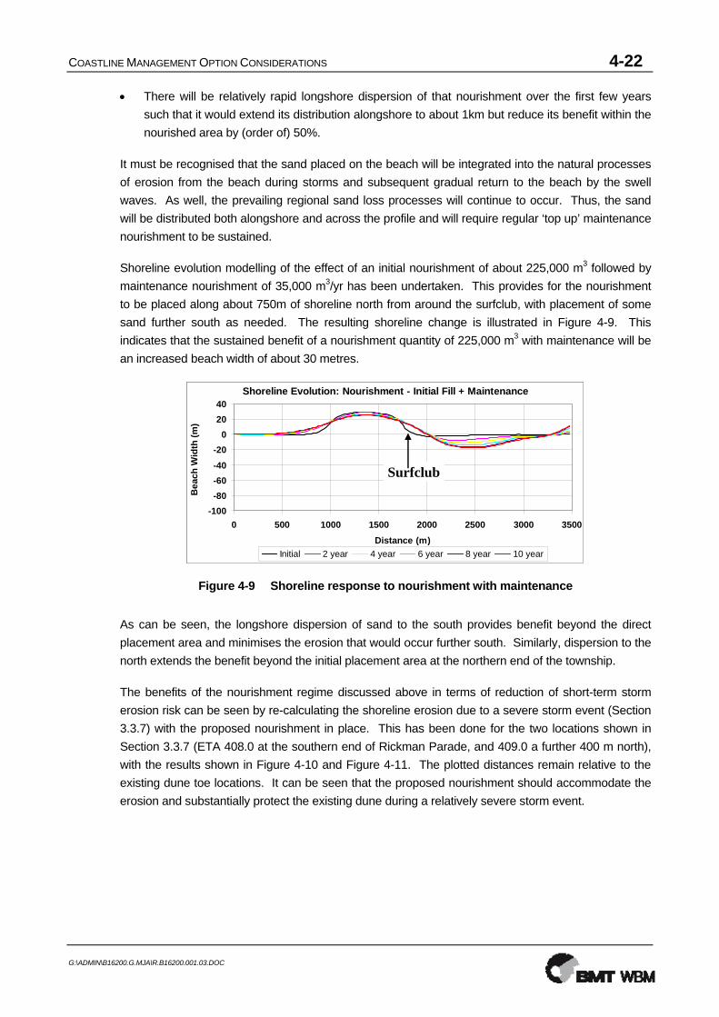
As a first assessment, the likely minimum quantity of sand required to restore a 1 km length of beach seaward of the existing dune would be about 225,000 cubic metres. This may be considered in the context that:
• This quantity, if placed initially along about 500-750m of the beach, represents beach widening by about 30-40 metres, extending from the berm (approx RL+2m AHD) to a depth of 6-8m; and
COASTLINE MANAGEMENT OPTION CONSIDERATIONS 4-22
G:\ADMIN\B16200.G.MJA\R.B16200.001.03.DOC
• There will be relatively rapid longshore dispersion of that nourishment over the first few years such that it would extend its distribution alongshore to about 1km but reduce its benefit within the nourished area by (order of) 50%.
It must be recognised that the sand placed on the beach will be integrated into the natural processes of erosion from the beach during storms and subsequent gradual return to the beach by the swell waves. As well, the prevailing regional sand loss processes will continue to occur. Thus, the sand will be distributed both alongshore and across the profile and will require regular ‘top up’ maintenance nourishment to be sustained.
Shoreline evolution modelling of the effect of an initial nourishment of about 225,000 m3 followed by maintenance nourishment of 35,000 m3/yr has been undertaken. This provides for the nourishment to be placed along about 750m of shoreline north from around the surfclub, with placement of some sand further south as needed. The resulting shoreline change is illustrated in Figure 4-9. This indicates that the sustained benefit of a nourishment quantity of 225,000 m3 with maintenance will be an increased beach width of about 30 metres.
Shoreline Evolution: Nourishment - Initial Fill + Maintenance
-100-80-60-40-20
02040
0 500 1000 1500 2000 2500 3000 3500Distance (m)
Bea
ch W
idth
(m)
Initial 2 year 4 year 6 year 8 year 10 year
Surfclub
Shoreline Evolution: Nourishment - Initial Fill + Maintenance
-100-80-60-40-20
02040
0 500 1000 1500 2000 2500 3000 3500Distance (m)
Bea
ch W
idth
(m)
Initial 2 year 4 year 6 year 8 year 10 year
Surfclub
Figure 4-9 Shoreline response to nourishment with maintenance
As can be seen, the longshore dispersion of sand to the south provides benefit beyond the direct placement area and minimises the erosion that would occur further south. Similarly, dispersion to the north extends the benefit beyond the initial placement area at the northern end of the township.
The benefits of the nourishment regime discussed above in terms of reduction of short-term storm erosion risk can be seen by re-calculating the shoreline erosion due to a severe storm event (Section 3.3.7) with the proposed nourishment in place. This has been done for the two locations shown in Section 3.3.7 (ETA 408.0 at the southern end of Rickman Parade, and 409.0 a further 400 m north), with the results shown in Figure 4-10 and Figure 4-11. The plotted distances remain relative to the existing dune toe locations. It can be seen that the proposed nourishment should accommodate the erosion and substantially protect the existing dune during a relatively severe storm event.

COASTLINE MANAGEMENT OPTION CONSIDERATIONS 4-23
G:\ADMIN\B16200.G.MJA\R.B16200.001.03.DOC
-6
-4
-2
0
2
4
6
8
10
-40 -20 0 20 40 60 80 100 120 140 160 180 200Distance from existing dune toe (m)
Level (m AHD)
Storm Water Level Wave envelope Erosion Profile Existing profile Nourished profile
Figure 4-10 Vellinga Storm Erosion Profile at ETA 408.0 With Nourishment.
-6
-4
-2
0
2
4
6
8
-40 -20 0 20 40 60 80 100 120 140 160 180 200Distance from existing dune toe (m)
Level (m AHD)
Storm Water Level Wave envelope Erosion Profile Existing profile Nourished profile
Figure 4-11 Vellinga Storm Erosion Profile at ETA 409.0 With Nourishment.
4.6.3.2 Beach Restoration by Nourishment with Control Structures
Control structures to provide increased stability to the nourishment may include either one or more groynes or an offshore breakwater. The design of such a scheme would seek to provide a suitable volume of sand that would ‘fill’ the sand trapping capacity of the structure such that adverse downdrift impacts are minimised.
However, these downdrift erosion impacts cannot be prevented entirely because:
• The alignment of the updrift beach will be altered such that the longshore transport rate there is slightly reduced to be in equilibrium with that somewhat further north;
• The natural trend of downdrift erosion will not be prevented; and
• The structure will have local effects on waves and currents that affect the immediate downdrift beach shape.
Shoreline evolution modelling of this option involving 3 groynes each of 30m length and nourishment directly equivalent to that modelled in Figure 4-9 (ie initial 225,000 m3 plus ongoing maintenance of 35,000 m3/yr) has been undertaken. The effect on the shoreline is shown in Figure 4-12.

COASTLINE MANAGEMENT OPTION CONSIDERATIONS 4-24
G:\ADMIN\B16200.G.MJA\R.B16200.001.03.DOC
Shoreline Evolution: 3x30m Groynes + Initial Fill & Nourishment
-100-80-60-40-20
02040
0 500 1000 1500 2000 2500 3000 3500Distance (m)
Bea
ch W
idth
(m)
Initial 2 year 4 year 6 year 8 year 10 year
Surfclub
Shoreline Evolution: 3x30m Groynes + Initial Fill & Nourishment
-100-80-60-40-20
02040
0 500 1000 1500 2000 2500 3000 3500Distance (m)
Bea
ch W
idth
(m)
Initial 2 year 4 year 6 year 8 year 10 year
Shoreline Evolution: 3x30m Groynes + Initial Fill & Nourishment
-100-80-60-40-20
02040
0 500 1000 1500 2000 2500 3000 3500Distance (m)
Bea
ch W
idth
(m)
Initial 2 year 4 year 6 year 8 year 10 year
Surfclub
Figure 4-12 Shoreline response to groynes with nourishment and maintenance
This shows that addition of the groynes would not substantially increase the benefit to their north while exacerbating erosion to the south relative to the nourishment only option. As such, the use of groynes even with nourishment would be less cost-effective while having other visual and functional disadvantages. As such, groynes are not recommended.
4.6.4 Dune Management
It is essential that a program of effective dune management be implemented to control wind erosion and help to build the foredune through the trapping ability of native dune plants in a manner consistent with the natural processes.
a) Natural vegetated dune and foredune system near Fifth Avenue, Woorim
b) Dune fencing to prevent pedestrian access and facilitate Spinifex growth for trapping wind blown
sand in the foredune
Dune management should involve as a minimum:
• Excluding pedestrian and other traffic from the vulnerable grassed or potentially grassed foredune areas where such traffic poses a threat to vegetation establishment and stability. Control fencing may be necessary in such areas. Such fencing should be located to enhance the process of grass growth and trapping of wind blown sand in the developing foredunes;

COASTLINE MANAGEMENT OPTION CONSIDERATIONS 4-25
G:\ADMIN\B16200.G.MJA\R.B16200.001.03.DOC
• Undertaking mulching or equivalent activities in areas where there is little or no natural vegetative protection from wind erosion of the dune face to prevent sand loss and/or abnormally high building of the dune crest, as has occurred at Woorim in the past;
• Construction and maintenance of controlled access paths to and from the beach;
• Where the nourishment and subsequent natural sand transport by the wind creates a foredune, stabilisation of that area with primary vegetation species (Spinifex) using techniques recommended by EPA.
a) Dune face damage and lack of foredune due to excessive pedestrian traffic. Control fencing is
needed.
b) Limited pedestrian control may be sufficient in some areas where damage to dune vegetation is
minimal.
4.6.5 Monitoring and Review Program
There is a need for monitoring in order to:
• gain an increasing level of basic knowledge of the beach processes at Woorim, particularly the rate of shoreline recession, and
• monitor the response to the proposed restoration works to assess their performance and guide future action.
A program of ongoing beach monitoring as discussed below should be implemented by Council to provide data on beach behaviour and response to works as a basis for future action planning. Some of the beach monitoring work to add to the available knowledge of how the beach behaves can be implemented immediately at low cost, while more comprehensive monitoring surveys require allocation of significant Council funds.
Low Cost Beach Monitoring
It is feasible to undertake simple but effective beach monitoring without significant expense. This may involve input from Council staff, surfclub members or volunteer residents, with minimal technical knowledge or expertise. Typically, it could include:
• Volunteer daily observations of waves, currents and sand transport at Woorim using established observation techniques (Patterson and Blair 1983); and

COASTLINE MANAGEMENT OPTION CONSIDERATIONS 4-26
G:\ADMIN\B16200.G.MJA\R.B16200.001.03.DOC
• Regular (say monthly) survey of selected beach cross-sections using simple techniques.
Comprehensive Monitoring Surveys
Comprehensive monitoring needs to be undertaken by appropriately qualified and experienced specialists, with a view to quantifying the processes taking place and the overall response of the beach system to the nourishment works, providing accurate and defensible data for consideration and assessment in any future action. This would involve:
• Detailed beach and offshore level surveys, initially six (6) monthly and subsequently less regularly, along the whole Woorim unit to quantify both the cross-shore sand movements (offshore dispersion of the nourishment and storm erosion) and the performance of the beach nourishment works in terms of:
o retention of the nourishment sand quantity, and
o any need for further maintenance nourishment action.
• Less detailed beach and nearshore level surveys, initially six (6) monthly and subsequently less regularly, along the adjacent areas to the north and south to quantify changes and impacts there.
Beach response survey undertaken in 1988 following nourishment
4.6.6 Planning and Regulatory Controls
4.6.6.1 Woorim Beach Management and Beach Access
The present management practices undertaken by Council along the developed part of Woorim are generally suitable. Key aspects that require continuing attention include the following:
(i) No sand is to be removed from the beach system (onshore and offshore);
(ii) No sand is to be removed and the dune vegetation protected to prevent wind erosion along the dune system; and
(iii) Controlled public paths and/or stairs should be provided at suitably spaced locations to ensure convenient and safe access to and from the beach.

COASTLINE MANAGEMENT OPTION CONSIDERATIONS 4-27
G:\ADMIN\B16200.G.MJA\R.B16200.001.03.DOC
4.6.6.2 Activities in Undeveloped Dune Areas
It is recommended that Council develop guidelines to regulate works and activities along the presently undeveloped dune system and within potential erosion hazard zones extending north and south adjacent to the Woorim township. This may involve integration with relevant regional and state planning provisions. The dune system should be managed in accordance with the methods and procedures recommended by EPA. Such management may include planting and protection of native dune vegetation, clearing of weed species and provision of controlled access across the dunes.
General regulations to protect the natural dune system could include:
(i) No structures may be erected or interference caused within the 100 year erosion prone dune, beach or nearshore areas. Such structures and interference includes buildings, roads, carparks, facilities, services, seawalls or other equivalent works as well as direct removal of sand or damage to dune vegetation causing wind erosion;
(ii) No sand is to be removed and the dune vegetation protected to prevent wind erosion along the dune system;
(iii) No subdivision of land to provide additional building lots which lie wholly or partially within the 100 year erosion prone area will be permitted unless it can be shown that the buildings provided for in the subdivision can be located wholly outside the erosion prone area.