3.9 Hydrology and Water Quality
34
3. Environmental Setting, Impacts, and Mitigation Measures 3.9 Hydrology and Water Quality Inglewood Basketball and Entertainment Center 3.9-1 ESA / 171236 Environmental Impact Report December 2019 3.9 Hydrology and Water Quality This section describes and evaluates potential impacts related to hydrology and water quality that could result from construction and operation of the Proposed Project. The section contains: (1) a description of the existing hydrology and water quality conditions of the Project Site and the surrounding areas, as well as a description of the Adjusted Baseline Environmental Setting; (2) a description of the regulatory federal, State, and local regulations related to hydrology and water quality; and (3) an analysis of the changes in hydrology and water quality associated with the implementation of the Proposed Project, as well as the identification of potentially feasible measures that could mitigate significant impacts. Comments received in response to the NOP for the EIR can be found in Appendix B; however, no specific comments regarding hydrology and water quality were provided. The analysis included in this section was developed based on information contained in the City of Inglewood General Plan, City of Inglewood Urban Water Management Plan, Golden State Water Company (GSWC) Urban Water Management Plan, Federal Emergency Management Agency (FEMA) Digital Flood Insurance Rate Maps (FIRMs), Groundwater Basins Master Plan, Enhanced Watershed Management Program for the Dominguez Channel Watershed, Los Angeles Regional Water Quality Control Board (RWQCB) Plan, the project-specific Water Supply Assessment (Appendix M), the Inglewood Basketball and Entertainment Center Low Impact Development (LID) Report (LID Report) (Appendix Q), and the Inglewood Basketball and Entertainment Center Preliminary Hydrology Report (Preliminary Hydrology Report) (Appendix Q). The LID Report outlines the proposed LID strategies and best management practices (BMPs) that would be implemented to comply with the stormwater requirements for the Proposed Project. The Preliminary Hydrology Report outlines the on-site hydrology and existing storm drain infrastructure that serves the Project Site as well as on-site hydrology (e.g., proposed drainage features, quantified stormwater flows, and new drainage infrastructure necessary to accommodate flows) of the Proposed Project. 3.9.1 Environmental Setting Surface Water The City of Inglewood is located in the Dominguez Channel Watershed, within the Upper Dominguez Channel drainage area. The Project Site is located approximately one-mile north of the start of the man-made Dominguez Channel, which begins at the City of Hawthorne and City of Inglewood boundary and discharges into the Los Angeles and Long Beach Harbors. 1 The Dominguez Channel Watershed encompasses approximately 133 square miles of land and water in the southern portion of the Los Angeles Basin. 2 Approximately 81 percent of the 1 City of Los Angeles Stormwater Program, 2018. Dominguez Channel Watershed. Available: http://www.lastormwater.org/about-us/about-watersheds/dominguez-channel/. Accessed October 2, 2018. 2 Los Angeles County Department of Public Works, 2018. Dominguez Watershed. Available: https://dpw.lacounty.gov/wmd/watershed/dc/. Accessed October 2, 2018.
Transcript of 3.9 Hydrology and Water Quality

3. Environmental Setting, Impacts, and Mitigation Measures 3.9 Hydrology and Water Quality
Inglewood Basketball and Entertainment Center 3.9-1 ESA / 171236 Environmental Impact Report December 2019
3.9 Hydrology and Water Quality This section describes and evaluates potential impacts related to hydrology and water quality that could result from construction and operation of the Proposed Project. The section contains: (1) a description of the existing hydrology and water quality conditions of the Project Site and the surrounding areas, as well as a description of the Adjusted Baseline Environmental Setting; (2) a description of the regulatory federal, State, and local regulations related to hydrology and water quality; and (3) an analysis of the changes in hydrology and water quality associated with the implementation of the Proposed Project, as well as the identification of potentially feasible measures that could mitigate significant impacts. Comments received in response to the NOP for the EIR can be found in Appendix B; however, no specific comments regarding hydrology and water quality were provided.
The analysis included in this section was developed based on information contained in the City of Inglewood General Plan, City of Inglewood Urban Water Management Plan, Golden State Water Company (GSWC) Urban Water Management Plan, Federal Emergency Management Agency (FEMA) Digital Flood Insurance Rate Maps (FIRMs), Groundwater Basins Master Plan, Enhanced Watershed Management Program for the Dominguez Channel Watershed, Los Angeles Regional Water Quality Control Board (RWQCB) Plan, the project-specific Water Supply Assessment (Appendix M), the Inglewood Basketball and Entertainment Center Low Impact Development (LID) Report (LID Report) (Appendix Q), and the Inglewood Basketball and Entertainment Center Preliminary Hydrology Report (Preliminary Hydrology Report) (Appendix Q). The LID Report outlines the proposed LID strategies and best management practices (BMPs) that would be implemented to comply with the stormwater requirements for the Proposed Project. The Preliminary Hydrology Report outlines the on-site hydrology and existing storm drain infrastructure that serves the Project Site as well as on-site hydrology (e.g., proposed drainage features, quantified stormwater flows, and new drainage infrastructure necessary to accommodate flows) of the Proposed Project.
3.9.1 Environmental Setting Surface Water The City of Inglewood is located in the Dominguez Channel Watershed, within the Upper Dominguez Channel drainage area. The Project Site is located approximately one-mile north of the start of the man-made Dominguez Channel, which begins at the City of Hawthorne and City of Inglewood boundary and discharges into the Los Angeles and Long Beach Harbors.1
The Dominguez Channel Watershed encompasses approximately 133 square miles of land and water in the southern portion of the Los Angeles Basin.2 Approximately 81 percent of the
1 City of Los Angeles Stormwater Program, 2018. Dominguez Channel Watershed. Available:
http://www.lastormwater.org/about-us/about-watersheds/dominguez-channel/. Accessed October 2, 2018. 2 Los Angeles County Department of Public Works, 2018. Dominguez Watershed. Available:
https://dpw.lacounty.gov/wmd/watershed/dc/. Accessed October 2, 2018.

3. Environmental Setting, Impacts, and Mitigation Measures 3.9 Hydrology and Water Quality
Inglewood Basketball and Entertainment Center 3.9-2 ESA / 171236 Environmental Impact Report December 2019
watershed has been developed. Residential development covers nearly 40 percent of the watershed and another 41 percent is made up by industrial, commercial, and transportation uses. Overall, the watershed is approximately 61 percent impervious. While constructed waterways are predominant, some small natural creeks are located in the hills of the Palos Verdes Peninsula. Because the majority of the watershed is urban, drainage is primarily conducted through an extensive network of underground storm drains.
The Dominguez Channel Watershed is designated as Hydrologic Unit 405.12 by the State Water Resources Control Board (SWRCB) and as the San Gabriel Hydrologic Unit by the Los Angeles RWQCB.3 Water bodies within the hydrologic unit include the Dominguez Channel, Wilmington Drain, Torrance/Carson Channel (“Torrance Lateral”), Machado Lake, Los Angeles and Long Beach Harbors, and Cabrillo Beach.
Approximately 70 square miles of the Dominguez Channel Watershed drains to the 15.7-mile-long Dominguez Channel, which is the largest drainage feature in the Dominguez Channel Watershed. The remaining portion of the Dominguez Channel Watershed drains to retention basins for groundwater recharge; into Wilmington Drain, which empties into Machado Lake; or to the Los Angeles Harbor or Long Beach Harbor independently of the Dominguez Channel.
Flows in the Dominguez Channel Watershed are influenced by the volume of surface runoff, local groundwater, and rainfall. The Los Angeles Basin has a Mediterranean climate with moderate, dry summers and cool winters, consistent with coastal Southern California. Precipitation in the region occurs primarily as rain from November through March, with an average annual rainfall of 12.02 inches.4 In general, stormwater runoff within the City of Inglewood, including the Project Site, flows into the Los Angeles County Flood Control District storm drain system.
Soil Drainage The Project Site currently consists of both pervious and impervious surfaces, including a fast-food restaurant, a motel, a light manufacturing/warehouse facility, a commercial catering business, a groundwater well and related facilities, and large portions of vacant land.
The Project Site is currently made up of approximately 15 percent impervious surfaces and 85 percent pervious surfaces. Preliminary investigations of the Project Site indicate that the site’s native soil characteristics have poor drainage with a low infiltration rate.5,6 According to the Los Angeles County Guidelines for LID Stormwater Infiltration, in order for soil to be pervious enough for stormwater to infiltrate the soil, subsurface materials must allow infiltration at a rate
3 State Water Resources Control Board, 2014. Basin Plan for the Coastal Watersheds of Los Angeles and Ventura
Counties. Available: https://www.waterboards.ca.gov/losangeles/water_issues/programs/basin_plan/basin_plan_documentation.html. Accessed October 4, 2018.
4 City of Inglewood, 2016. 2015 Urban Water Management Plan. p. 3-4. 5 AECOM, 2018. Inglewood Basketball & Entertainment Center Project Low Impact Development (LID) Report.
August 23, 2018. p. 2. 6 AECOM, 2018. Preliminary Geotechnical Investigation. September 14, 2018. p. 34.
3. Environmental Setting, Impacts, and Mitigation Measures 3.9 Hydrology and Water Quality
Inglewood Basketball and Entertainment Center 3.9-3 ESA / 171236 Environmental Impact Report December 2019
equal to or greater than 0.3 inches per hour.7 Preliminary percolation tests were conducted at five selected locations at the Project Site. Based on the results, infiltration rates for the soils in the upper 10 feet ranged from 0.32 to 3.52 inches per hour. However, the subsurface native soils at the Project Site consist predominately of clayey soils with estimated infiltration rates lower than 0.3 inches per hour and with few or no connectivity to permeable soil horizons. Moreover, there is no evidence that the underlying, predominantly clayey soils at the Project Site have experienced saturation. These characteristics indicate that the Project Site has a low infiltration rate, and provides very little groundwater recharge through percolation of soils.
Drainage Infrastructure Arena Site The Arena Site is the central part of the Project Site that would include the arena, public plaza, community space, practice facility, sports medicine clinic, team offices, retail/restaurants, a parking structure, and related development. The Arena Site currently includes a fast-food restaurant, a motel, a light manufacturing/warehouse facility, a commercial catering business, a City groundwater well and related facilities, and large portions of vacant land.
West 102nd Street crosses through the Arena Site in an east-west direction. Storm drainage facilities serving this portion of the Project Site include a 60-inch-diameter storm drain pipeline within South Prairie Avenue, known as the Los Angeles County Department of Public Works (LACDPW) Storm Drain Line Project 681.8,9,10 In addition, an existing catch basin is located at the intersection of West 102nd Street and South Prairie Avenue.
West Parking Garage Site The West Parking Garage Site is currently vacant, with West 101st Street crossing through the site in an east-west direction. This site would include a multi-level parking structure to serve patrons of the Arena Site.
The West Parking Garage Site is served by a 24-inch-diameter storm drain pipeline (the LACDPW Storm Drain Line Project 4402) that begins in West 101st Street, travels north to West Century Boulevard, turns east along West Century Boulevard, and then turns north and south along South Prairie Avenue, connecting to the abovementioned 60-inch-diameter storm drain pipeline within South Prairie Avenue (LACDPW Storm Drain Line Project 681).
East Transportation and Hotel Site This portion of the Project Site is located east of the Arena Site and would include a three-story parking garage along West Century Boulevard, with the first floor serving as a transportation hub. The transportation hub includes a staging area for private or charter buses and a drop-off, staging,
7 County of Los Angeles Department of Public Works, 2014. Administrative Manual: Guidelines for Design,
Investigation, and Reporting Low Impact Development Stormwater Infiltration. p. 2. 8 AECOM, 2018. Existing Conditions Plan Sheet C-101. August 29, 2018. 9 Los Angeles County Department of Public Works, 2019. Los Angeles County Storm Drain System. Accessed
February 8, 2019. 10 D&D Engineering Inc., 2019. Preliminary Hydrology Report.

3. Environmental Setting, Impacts, and Mitigation Measures 3.9 Hydrology and Water Quality
Inglewood Basketball and Entertainment Center 3.9-4 ESA / 171236 Environmental Impact Report December 2019
and pick-up area for TNC vehicles and taxis serving the Arena Site. The second and third floors of the garage would provide parking for patrons of the Arena Site. The east side of the East Transportation and Hotel Site would include a limited-service hotel and associated parking facilities.
The East Transportation and Hotel Site is currently vacant. Storm drainage pipelines serving this portion of the Project Site are located within South Doty Avenue (LACDPW Storm Drain Line Project 4401, which is 84 inches in diameter). In addition, a 48-inch-diameter storm drainage pipeline crosses under parcels to the west of the East Transportation and Hotel Site, extending north through West Century Boulevard and south through West 102nd Street (LACDPW Storm Drain Line Project DDI #8).
Well Relocation Site The Well Relocation Site is located east of the Arena Site and would contain a City-owned and operated potable water well. The Well Relocation Site is currently vacant. This portion of the Project Site is adjacent to storm drainage pipelines within West 102nd Street (LACDPW Storm Drain Line Project DDI #8) and South Doty Avenue (LACDPW Storm Drain Line Project 4401), detailed above.
Groundwater The City of Inglewood is located over two groundwater basins: the West Coast Groundwater Basin (WCGB) and the Central Basin. While the Project Site is located only within the WCGB, the Proposed Project would be served by the GSWC, which produces water from both the WCGB and Central Basin. Characteristics of both the WCGB and Central Basin are described below.
West Coast Groundwater Basin The WCGB is approximately 160 square miles and occupies 37 percent of the southwestern part of the Los Angeles Coastal Plain.11 The WCGB is bounded to the north by the Ballona Escarpment (an abandoned erosion channel from the Los Angeles River), on the east by the Newport-Inglewood fault zone and the Central Basin, and on the south and west by the Pacific Ocean.
Aquifers in the WCGB are generally confined and receive the majority of their natural replenishment from adjacent groundwater basins or from the Pacific Ocean through seawater intrusion.12 Both the Newport-Inglewood Uplift fault and the Charnock fault are partial barriers to groundwater flow, causing differences in water levels on opposite sides of each fault system. Most of the groundwater in the WCGB is at an elevation below sea level due to historic over pumping, making maintenance of seawater barrier wells important to prevent intruding saltwater.
11 City of Inglewood, 2016. 2015 Urban Water Management Plan. p. 6-7. 12 Water Replenishment District of Southern California, 2016. Groundwater Basins Master Plan. Available:
https://www.wrd.org/sites/pr/files/GBMP_FinalReport_Text%20and%20Appendicies.pdf. Accessed October 3, 2018. p. 1-4.

3. Environmental Setting, Impacts, and Mitigation Measures 3.9 Hydrology and Water Quality
Inglewood Basketball and Entertainment Center 3.9-5 ESA / 171236 Environmental Impact Report December 2019
The WCGB is underlain by various geologic formations. Water bearing formations include Holocene, Pleistocene, and Pliocene age sediments.13 The Silverado aquifer, underlying most of the Basin, is the primary production aquifer and yields between 80 and 90 percent of the groundwater extracted from the WCGB. Other aquifers within the WCGB include the Semiperched, Bellflower, Gaspur, Gardena, Gage, and Lynwood aquifers.14 The groundwater in the underlying aquifers is confined throughout most of the WCGB; however, the Gage and Gardena aquifers are unconfined where water levels have dropped below the Bellflower aquitard.15 The Gage and Gardena aquifers merge with adjacent aquifers, particularly near the Redondo Beach area.
The WCGB has a total storage capacity of 6,500,000 acre-feet (AF).16 Prior to the adjudication of groundwater rights in the early 1960s, annual pumping of the WCGB reached levels as high as 94,000 AF per year (AFY). Due to serious overdraft, water levels declined, groundwater was lost from storage, and seawater intruded into the aquifer. To remedy this problem, the courts adjudicated the basin to limit pumping, and the WCGB adjudication has an established limit on pumping of 64,468 AFY. The City of Inglewood’s adjudicated share of water rights to the WCGB is 4,449 AFY, and the GSWC’s adjudicated share of water rights to WCGB is 7,502 AFY.
The natural replenishment of the WCGB is limited to underflow from the Central Basin, which has been estimated to be between 20,000 and 30,000 AFY.17 The total authorized pumping of the WCGB was set higher than the natural replenishment amounts, creating an annual deficit known as the annual overdraft. In order to offset this annual overdraft, the Water Replenishment District of Southern California (WRD), which is the entity responsible for maintaining the WCGB, purchases and recharges additional water to make up for the overdraft.
The City of Inglewood and the GSWC own and operate wells that extract groundwater from the WCGB. The City of Inglewood currently produces groundwater from the WCGB via four active groundwater wells. Water Wells #1, 2, 4, and 6, were constructed in 1974, 1974, 1990, and 2003, respectively, and together have been producing an average of 1,646 gallons per minute (gpm) over the period of 2008 to 2015.18 In March 2021, the City of Inglewood is planning on completing the construction of Water Well #7. Water Well #7 is designed to operate at 1,500 gpm.
GSWC operates ten wells within their Southwest System, eight of which are located within the WCGB and five of which are located within the City of Inglewood (Water Wells #1, 2, 4, 6, and 7).19 Table 3.9-1 shows historical well production from the WCGB for both the City of 13 City of Inglewood, 2016. 2015 Urban Water Management Plan. p. 6-7. 14 California Department of Water Resources, 2004. California’s Groundwater Bulletin 118: Coastal Plan of
Los Angeles County Groundwater Basin, West Coast Subbasin. 15 An aquitard is a zone of subsurface materials that restricts the flow of groundwater from one aquifer to another. 16 City of Inglewood, 2016. 2015 Urban Water Management Plan. p. 6-7. 17 Water Replenishment District of Southern California, 2016. Groundwater Basins Master Plan. Available:
https://www.wrd.org/sites/pr/files/GBMP_FinalReport_Text%20and%20Appendicies.pdf. Accessed October 3, 2018.
18 City of Inglewood, 2016. 2015 Urban Water Management Plan. p. 6-11. 19 Golden State Water Company, 2016. 2015 Urban Water Management Plan, Southwest. pp. 6-8 through 6-10.

3. Environmental Setting, Impacts, and Mitigation Measures 3.9 Hydrology and Water Quality
Inglewood Basketball and Entertainment Center 3.9-6 ESA / 171236 Environmental Impact Report December 2019
Inglewood and the GSWC. Based on available data, groundwater pumped from the WCGB generally declined from 2011 to 2015 due to strong conservation efforts in response to a state-wide drought as well as operational issues.20
TABLE 3.9-1 WCGB HISTORICAL WELL PRODUCTION (AFY)
Entity 2011a 2012a 2013a 2014a 2015a 2016–17b 2017–18b
City of Inglewood 2,383 2,761 1,843 1,879 1,763 2,483 2,073
GSWC 13,116 12,732 12,738 13,333 5,484 3,172 7,028
Total 15,499 15,493 14,581 15,212 7,247 5,655 9,101
NOTE: The notable decrease in GSWC well production in 2015 and 2016 was due to conservation efforts and operational issues.
SOURCES: a City of Inglewood, 2016. 2015 Urban Water Management Plan. p. 6-11.; Golden State Water Company, 2016. 2015 Urban Water
Management Plan, Southwest. p. 6-10. b Water Replenishment District 2017 and 2018 Watermaster Service Reports. Note the Watermaster reports use an Administrative
Year which is July 1 to June 30.
The City of Inglewood Water Well #6 is located within the Project Site. As part of the Proposed Project, the existing Water Well #6 would be demolished, and a new Water Well #68 would be constructed on the Well Relocation Site. The existing Water Well #6 was constructed in 2003 and has been experiencing declining pumping capacity over the years.21 Table 3.9-2 shows the City’s historical well production from Water Well #6. The original recommended flow rate for Well #6 was 2,800 gpm. The well pump was replaced in 2011 with a reduced flow of 1,400 gpm; however, mechanical issues and emergency repairs reduced the average day use to approximately 1,200 gpm (or approximately 1,550 AFY). As shown in Table 3.9-2, in 2017, the most recent year for which data is available, Water Well #6 produced a total of 1,026 AF. Water Well #6 is scheduled for emergency repair and rehabilitation to increase its capacity to 1,500 gpm. The rehabilitation work would seal off holes in the casing and cleaning perforations.
TABLE 3.9-2 WATER WELL #6 HISTORICAL WELL PRODUCTION (AFY)
Well 2008 2009 2010 2011 2012 2013 2014 2015 2016a 2017a
Water Well #6 2,055 1,810 1,441 1,062 1,835 1,288 1,493 1,330 1,256 1,026
SOURCES: City of Inglewood, 2016. 2015 Urban Water Management Plan. p. 6-11. a City of Inglewood, 2019. Well Production and Water Consumption Data Years 2016 and 2017.
According to the project-specific Preliminary Geotechnical Report (see Appendix H), the historically highest groundwater level in the vicinity of the Project Site was greater than 50 feet
20 City of Inglewood, 2016. 2015 Urban Water Management Plan. p. 6-9. 21 City of Inglewood, 2018. Proposed Well Number 8 Preliminary Design Report. July. p. 1.

3. Environmental Setting, Impacts, and Mitigation Measures 3.9 Hydrology and Water Quality
Inglewood Basketball and Entertainment Center 3.9-7 ESA / 171236 Environmental Impact Report December 2019
below existing grade.22 The existing Water Well #6 is screened at approximately 400 feet below grade.
Central Basin The Central Basin, or southeastern portion of the Los Angeles Coastal Plain, has a surface area of approximately 270 square miles.23 The Central Basin is bounded to the north by the Hollywood Basin and the Elysian, Repetto, Merced, and Puente Hills; to the east by the Los Angeles County/Orange County line; and to the south and west by the Newport-Inglewood fault zone and the WCGB.
Similar to the WCGB, water bearing deposits in the Central Basin include the unconsolidated and semi-consolidated marine and alluvial sediments of Holocene, Pleistocene, and Pliocene ages.24 The Central Basin is divided into four sections, including the Los Angeles Forebay,25 the Montebello Forebay, the Whittier Area, and the Pressure Area.26 The two forebays represent areas of unconfined aquifers that allow percolation of surface water down to deeper production aquifers to replenish the rest of the basin. The Whittier Area and Pressure Area are confirmed aquifer systems that receive relatively minimal recharge from surface water, but are replenished from the upgradient forebay areas or other groundwater basins. As detailed above, the Newport-Inglewood Uplift fault is a partial barrier to groundwater flow, causing differences in water levels on opposite sides of the fault system. Groundwater flows between the WCGB and Central Basin are based on the groundwater elevations on either side of the fault. Most of the groundwater in the Central Basin remains at an elevation below sea level due to historic over pumping.
The Central Basin has an estimated storage capacity of approximately 13.8 million AF.27 The Central Basin was adjudicated by the courts in 1965 due to over pumping and a decline in water levels. The Central Basin adjudication was originally set at 267,900 AFY and adjusted to 217,367 AFY to impose stricter control.28 The GSWC’s adjudicated share of water rights is 16,439 AFY.29 Similar to the WCGB, WRD is responsible for maintaining water levels in the Central Basin, and determines replenishment requirements.
The City of Inglewood does not own or operate wells within the Central Basin. The GSWC operates two wells that are located within the Central Basin (Bellhaven Number 3 and Bellhaven
22 AECOM, 2018. Preliminary Geotechnical Investigation. September 14, 2018. p. 10. 23 Water Replenishment District of Southern California, 2016. Groundwater Basins Master Plan. Available:
https://www.wrd.org/sites/pr/files/GBMP_FinalReport_Text%20and%20Appendicies.pdf. Accessed October 3, 2018. p. 1-3.
24 Todd Groundwater, 2018. Water Supply Assessment: Golden State Water Company – Southwest, Inglewood Basketball and Entertainment Center. September.
25 A forebay is an artificial pool of water in front of a larger body of water that may be man-made. 26 Water Replenishment District of Southern California, 2016. Groundwater Basins Master Plan. Available:
https://www.wrd.org/sites/pr/files/GBMP_FinalReport_Text%20and%20Appendicies.pdf. Accessed October 3, 2018. p. 1-4.
27 Golden State Water Company, 2016. 2015 Urban Water Management Plan, Southwest. p. 6-4. 28 Water Replenishment District of Southern California, 2016. Groundwater Basins Master Plan. Available:
https://www.wrd.org/sites/pr/files/GBMP_FinalReport_Text%20and%20Appendicies.pdf. Accessed October 3, 2018. p. 1-4.
29 Golden State Water Company, 2016. 2015 Urban Water Management Plan, Southwest. p. 7-6.

3. Environmental Setting, Impacts, and Mitigation Measures 3.9 Hydrology and Water Quality
Inglewood Basketball and Entertainment Center 3.9-8 ESA / 171236 Environmental Impact Report December 2019
Number 4), which have a combined total design well capacity of 3,468 AFY.30 Table 3.9-3 shows GSWC’s historical well production from the Central Basin. Similar to the WCGB, groundwater pumped from the Central Basin has declined from 2011 to 2015 due to strong conservation efforts in response to a state-wide drought.
TABLE 3.9-3 CENTRAL BASIN HISTORICAL WELL PRODUCTION (AFY)
Entity 2011 2012 2013 2014 2015
GSWC 3,260 3,250 2,920 2,861 430
NOTE: The notable decrease in GSWC well production in 2015 and 2016 was due to conservation efforts and operational issues.
SOURCE: Golden State Water Company, 2016. 2015 Urban Water Management Plan, Southwest.
Flooding Natural flooding within the City of Inglewood is not a common occurrence, as the region’s largest river, the Los Angeles River, does not flow through the City’s boundaries. The Dominguez Channel, which begins at the City of Hawthorne and City of Inglewood boundary convergence, does not have a history of flooding into the adjacent neighborhoods. In addition, the Project Site is flat with only gentle slopes and is not near the Pacific Ocean, and, thus, is not located within a seiche or tsunami flooding inundation zone.
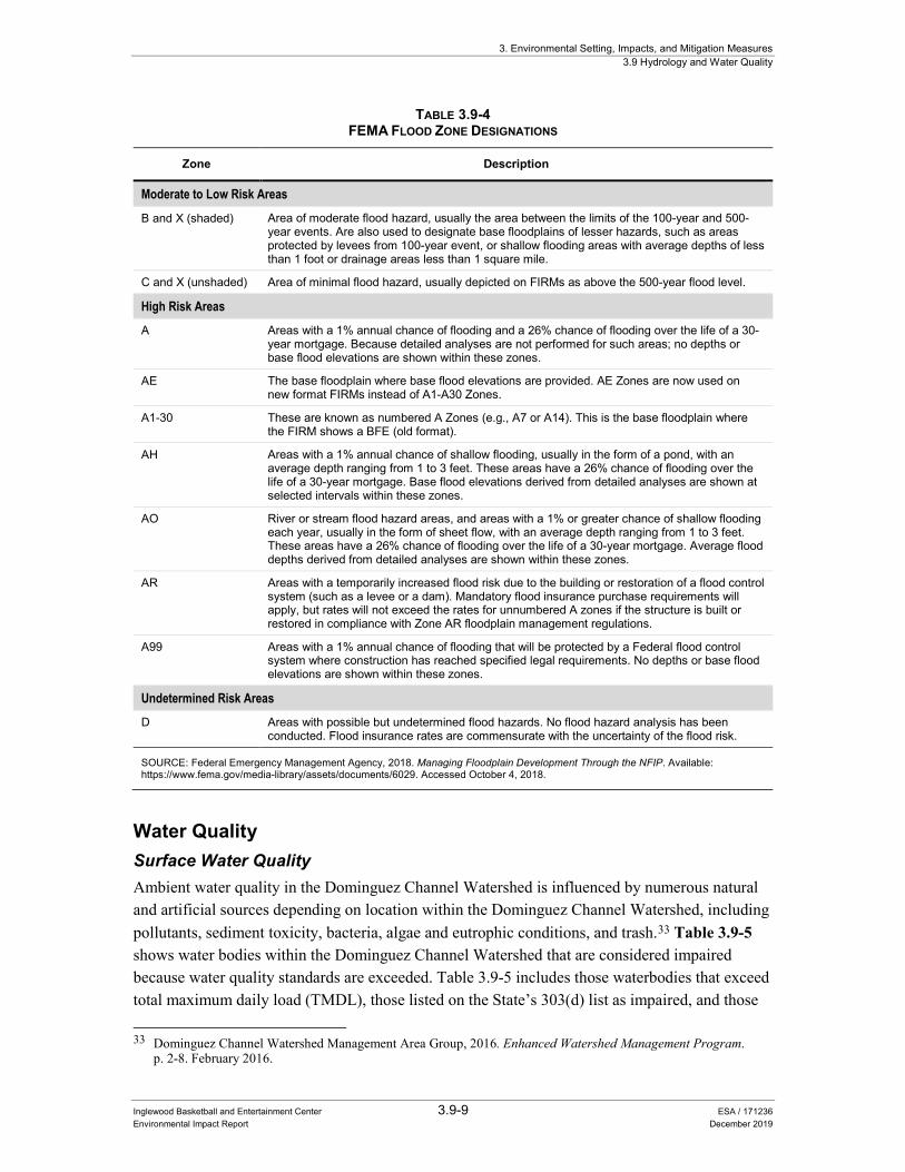
FEMA administers the National Flood Insurance Program (NFIP) that delineates areas subject to flood hazards on FIRMs for each community participating in the NFIP. The FIRMs show the areas subject to inundation by a flood that has a 1 percent chance or greater of being equaled or exceeded in any given year. This type of flood is commonly referred to as the 100-year or base flood. Areas on FIRMs are divided into geographic areas, or zones, that FEMA has defined according to varying levels of flood risk. Table 3.9-4 includes a description of the risk associated with each zone.
The Project Site is designated as Zone X (unshaded), which means the Project Site is in an area above the 500-year flood level.31 Over time, climate change may increase the potential for localized and regional flooding to occur.32 However, in the event that flooding would occur in the Dominquez Channel, the channel is located downstream of the Project Site.
30 Golden State Water Company, 2016. 2015 Urban Water Management Plan, Southwest. p. 6-8. 31 Federal Emergent Management Agency, 2018. FEMA Flood Map Service Center, City of Inglewood, Map Number
06037C1780G. Available: https://msc.fema.gov/portal/search#searchresultsanchor. Accessed February 9, 2019. 32 California Governor’s Office of Planning and Research, 2018. California’s Fourth Climate Change Assessment Los
Angeles Region Report. Available: http://www.climateassessment.ca.gov/regions/docs/20180928-LosAngeles.pdf. Accessed February 27, 2019.
3. Environmental Setting, Impacts, and Mitigation Measures 3.9 Hydrology and Water Quality
Inglewood Basketball and Entertainment Center 3.9-9 ESA / 171236 Environmental Impact Report December 2019
TABLE 3.9-4 FEMA FLOOD ZONE DESIGNATIONS
Zone Description
Moderate to Low Risk Areas
B and X (shaded) Area of moderate flood hazard, usually the area between the limits of the 100-year and 500-year events. Are also used to designate base floodplains of lesser hazards, such as areas protected by levees from 100-year event, or shallow flooding areas with average depths of less than 1 foot or drainage areas less than 1 square mile.
C and X (unshaded) Area of minimal flood hazard, usually depicted on FIRMs as above the 500-year flood level.
High Risk Areas A Areas with a 1% annual chance of flooding and a 26% chance of flooding over the life of a 30-
year mortgage. Because detailed analyses are not performed for such areas; no depths or base flood elevations are shown within these zones.
AE The base floodplain where base flood elevations are provided. AE Zones are now used on new format FIRMs instead of A1-A30 Zones.
A1-30 These are known as numbered A Zones (e.g., A7 or A14). This is the base floodplain where the FIRM shows a BFE (old format).
AH Areas with a 1% annual chance of shallow flooding, usually in the form of a pond, with an average depth ranging from 1 to 3 feet. These areas have a 26% chance of flooding over the life of a 30-year mortgage. Base flood elevations derived from detailed analyses are shown at selected intervals within these zones.
AO River or stream flood hazard areas, and areas with a 1% or greater chance of shallow flooding each year, usually in the form of sheet flow, with an average depth ranging from 1 to 3 feet. These areas have a 26% chance of flooding over the life of a 30-year mortgage. Average flood depths derived from detailed analyses are shown within these zones.
AR Areas with a temporarily increased flood risk due to the building or restoration of a flood control system (such as a levee or a dam). Mandatory flood insurance purchase requirements will apply, but rates will not exceed the rates for unnumbered A zones if the structure is built or restored in compliance with Zone AR floodplain management regulations.
A99 Areas with a 1% annual chance of flooding that will be protected by a Federal flood control system where construction has reached specified legal requirements. No depths or base flood elevations are shown within these zones.
Undetermined Risk Areas D Areas with possible but undetermined flood hazards. No flood hazard analysis has been
conducted. Flood insurance rates are commensurate with the uncertainty of the flood risk.
SOURCE: Federal Emergency Management Agency, 2018. Managing Floodplain Development Through the NFIP. Available: https://www.fema.gov/media-library/assets/documents/6029. Accessed October 4, 2018.
Water Quality Surface Water Quality Ambient water quality in the Dominguez Channel Watershed is influenced by numerous natural and artificial sources depending on location within the Dominguez Channel Watershed, including pollutants, sediment toxicity, bacteria, algae and eutrophic conditions, and trash.33 Table 3.9-5 shows water bodies within the Dominguez Channel Watershed that are considered impaired because water quality standards are exceeded. Table 3.9-5 includes those waterbodies that exceed total maximum daily load (TMDL), those listed on the State’s 303(d) list as impaired, and those 33 Dominguez Channel Watershed Management Area Group, 2016. Enhanced Watershed Management Program.
p. 2-8. February 2016.

3. Environmental Setting, Impacts, and Mitigation Measures 3.9 Hydrology and Water Quality
Inglewood Basketball and Entertainment Center 3.9-10 ESA / 171236 Environmental Impact Report December 2019
without an associated TMDL or on the State’s 303(d), list but showing exceedances of water quality criteria.
TABLE 3.9-5 LOCAL WATERBODIES EXCEEDING WATER QUALITY STANDARDS
Water body TMDL 303(d) List Other
Dominguez Channel (lined portion above Vermont Avenue)
Copper, Lead, Zinc, Toxicity Indicator Bacteria, Ammonia, Diazinon
Cadmium, Chromium, Mercury, Thallium, Bis (2-Ethylhexl) phthalate, pH, Dissolved Oxygen
Torrance Lateral Copper, Lead, Zinc Coliform Bacteria
Cadmium, Cyanide, pH, Ammonia, PCBs, DDT
Dominguez Estuary (unlined portion below Vermont Avenue)
Cadmium, Copper, Lead, Zinc, DDT, Chlordane, Dieldrin, PAHs, Benthic Community Effects, Sediment Toxicity
Ammonia, Coliform Bacteria
Arsenic, Chromium, Silver, Nickel, Mercury, Thallium
Machado Lake Trash, Total Phosphorus, Total Nitrogen, Ammonia, Chlorophyll-a, PCBs, DDT, Chlordane, Dieldrin, Dissolved Oxygen
None E. coli, pH
Wilmington Drain None Coliform Bacteria, Copper, Lead
Total Nitrogen, DDT, PCBs, Chlordane, Dieldrin
LA Harbor – Cabrillo Marina
DDT, PCBs, PAHs None None
LA Harbor – Consolidated Slip
Cadmium, Chromium, Copper, Lead, Mercury, Zinc, DDT, PCBs, PAHs, Chlordane, Dieldrin, Toxaphene, Benthic Community Effects, Sediment Toxicity
None Arsenic, Silver, Nickel
LA Harbor – Fish Harbor
Copper, Lead, Mercury, Zinc, DDT, PCBs, Chlordane, PAHs, Sediment Toxicity
None None
LA/Long Beach Inner Harbor
Copper, Zinc, DDT, PCBs, PAHs, Benthic Community Effects, Sediment Toxicity, Indicator Bacteria
None Copper, Silver
LA/Long Beach Outer Harbor
DDT, PCBs, Sediment Toxicity None Cadmium, Nickel, Silver, Copper, Mercury
LA Harbor – Inner Cabrillo Beach
Indicator Bacteria, DDT, PCBs None None
NOTE: Clean Water Act (CWA) section 303(d) requires the identification of water bodies that do not meet, or are not expected to meet, water quality standards (i.e., impaired water bodies), and these water bodies are placed on the 303(d) List of Water Quality Limited Segments. The affected water body, and associated pollutant or stressor, is then prioritized in the 303(d) list. Once a water body is placed on the 303(d) list, it remains on the list until a TMDL is adopted and the water quality standards are attained or there are sufficient data to demonstrate that water quality standards have been met and delisting should take place.
SOURCE: Dominguez Channel Watershed Management Area Group, 2016. Enhanced Watershed Management Program. p. 2-8. February 2016.
Dominguez Channel drains a highly industrialized area with numerous sources of pollution. These pollutants include polycyclic aromatic hydrocarbons (PAHs), remnants of persistent legacy pesticides, polychlorinated biphenyls (PCBs), and elevated concentrations of metals, all of which

3. Environmental Setting, Impacts, and Mitigation Measures 3.9 Hydrology and Water Quality
Inglewood Basketball and Entertainment Center 3.9-11 ESA / 171236 Environmental Impact Report December 2019
contribute to poor sediment quality both within the channel and adjacent harbor areas.34 Historically, oil pumping was prevalent in the area and some oil wells remain in operation.
In addition, the pollutant dichlorodiphenyltrichloroethane (DDT), a once common herbicide, is highest (compared to the rest of the Dominguez Channel Watershed) in the Dominguez Channel estuary and Consolidated Slip35 sediments, along with being present throughout the harbors. Elevated concentrations are present in sediment at some locations in the inner harbors, and at the Consolidated Slip. The presence of these sediment pollutants has adversely affected water quality.
Beneficial uses identified by the Los Angeles RWQCB for the surface water bodies in the Dominguez Channel Watershed are summarized in Table 3.9-6.
TABLE 3.9-6 BENEFICIAL USES LISTED FOR SURFACE WATERS WITHIN THE DOMINGUEZ CHANNEL WATERSHED
Water Body Existing Beneficial Uses Potential
Beneficial Uses
Dominguez Channel
Lined portion above Vermont Avenue (Freshwater)
RARE, REC-2 WARM, WILD, REC-1, MUN
Unlined portion below Vermont Avenue (Estuary)
COMM, EST, MAR, WILD, RARE, MIGR, SPWN, REC-1, REC-2
NAV
Torrance Carson Channel RARE, REC-2 WARM, WILD, REC-1, MUN
Machado Lake
Machado Lake WARM, WILD, WET, REC-1, REC-2 None
Wilmington Drain WARM, WILD, WET, REC-1, REC-2 None
Los Angeles Harbor
Consolidated Slip IND, NAV, REC-2, COMM, MAR, RARE REC-1, SHELL
Inner Harbor IND, NAV, REC-2, COMM, MAR, RARE REC-1, SHELL
Fish Harbor IND, NAV, REC-2, COMM, MAR, RARE REC-1, SHELL
Inner Cabrillo Beach NAV, REC-1, REC-2, COMM, MAR, WILD, MIGR, SPWN, SHELL
None
Outer Cabrillo Beach (Los Angeles County beach)
NAV, REC-1, REC-2, COMM, MAR, WILD, MIGR, SPWN, SHELL
None
NOTES: COMM: Commercial and Sport Fishing EST: Estuarine Habitat IND: Industrial Service Supply NAV: Navigation MAR: Marine Habitat MIGR: Migration of Aquatic Organisms MUN: Municipal and Domestic Supply RARE: Rare, Threatened, or Endangered Species
REC-1: Water Contact Recreation REC-2: Non-Contact Water Recreation SHELL: Shellfish Harvesting SPWN: Spawning, Reproduction, and/or Early Development WARM: Water Freshwater Habitat WET: Wetland Habitat WILD: Wildlife Habitat
SOURCE: Dominguez Channel Watershed Management Area Group, 2016. Enhanced Watershed Management Program. p. 1-6. February 2016.
34 State Water Resources Control Board, 2014. Basin Plan for the Coastal Watersheds of Los Angeles and Ventura
Counties. Available: https://www.waterboards.ca.gov/losangeles/water_issues/programs/basin_plan/basin_plan_documentation.html. Accessed October 4, 2018.
35 Consolidated Slip is a part of the Inner Harbor of Los Angeles Harbor immediately downstream of Dominguez Channel.

3. Environmental Setting, Impacts, and Mitigation Measures 3.9 Hydrology and Water Quality
Inglewood Basketball and Entertainment Center 3.9-12 ESA / 171236 Environmental Impact Report December 2019
Groundwater Quality City of Inglewood wells in the WCGB, and GSWC have historically produced and currently produce groundwater that meets federal and state water quality standards.36,37 However, the WCGB has water quality constituents of concern, including iron, manganese, hydrogen sulfide odor, and total dissolved solids. In order to address these constituents, WCGB wells have treatment processes and are monitored closely. Groundwater is treated for iron and manganese at the City of Inglewood’s Sanford M. Anderson Water Treatment Plant to meet water quality standards.
The Salt and Nutrient Management Plan for the Central Basin and WCGB, which is a tool to monitor and manage salt and nutrient levels in these groundwater basins was adopted by the Los Angeles RWQCB, on February 12, 2015.38,39 WCGB groundwater aquifers do not meet water quality objectives of the Los Angeles RWQCB because of historical seawater intrusion due to excessive over-pumping.40 However, existing and planned implementation measures (including barrier projects, desalters, recharge projects, and other programs) are designed to ensure that salt and nutrient levels in groundwater would achieve water quality objectives.41
3.9.2 Adjusted Baseline Environmental Setting Section 3.9, Hydrology and Water Quality, assumes the HPSP Adjusted Baseline Environmental Setting as described in Section 3.0, Introduction to the Analysis.
In its current (2019) condition, a portion of the HPSP area is under construction, largely resulting in pervious exposed soils, haul roads, and some paved areas. Compared to the site’s previous use as a horse racetrack and current construction conditions, the HPSP Adjusted Baseline projects will add impervious surfaces. At the time of the opening of the Proposed Project, the permeability of the HPSP Adjusted Baseline projects area would be limited to landscaped areas and retention basins, which would be designed to reduce runoff and treat pollutants of concern in accordance with drainage control regulatory requirements.
Drainage infrastructure at the HPSP area associated with the previous horse racetrack is currently being rerouted and replaced as necessary and additional drainage infrastructure will be constructed to accommodate the new HPSP Adjusted Baseline projects. New drainage infrastructure includes various on-site drains, open-channel drainage, an off-site bypass north of the HPSP area, catch basins, vegetated bio-retention areas, and an Arroyo and Lake Park
36 Golden State Water Company, 2016. 2015 Urban Water Management Plan, Southwest. p. 6-5. 37 City of Inglewood, 2016. 2015 Urban Water Management Plan. p. 6-13. 38 Water Replenishment District of Southern California, 2015. Salt and Nutrient Management Plan, Central Basin and
West Coast Basin, Southern Los Angeles County, California. February 12, 2015. 39 California Regional Water Quality Control Board, Los Angeles Region, 2015. Resolution No. R15-001,
Amendment to the Water Quality Control Plan for the Los Angeles Region to Incorporate Stakeholder-Proposed Groundwater Quality Control Measures for Salts and Nutrients in the Central and West Coast Groundwater Basins. February 12, 2015.
40 Water Replenishment District of Southern California, 2015. Salt and Nutrient Management Plan, Central Basin and West Coast Basin, Southern Los Angeles County, California. p. 14. February 12, 2015.
41 Todd Groundwater, 2018. Water Supply Assessment: Golden State Water Company – Southwest, Inglewood Basketball and Entertainment Center. September.

3. Environmental Setting, Impacts, and Mitigation Measures 3.9 Hydrology and Water Quality
Inglewood Basketball and Entertainment Center 3.9-13 ESA / 171236 Environmental Impact Report December 2019
stormwater treatment system. The HPSP Adjusted Baseline projects will include BMPs as required by the site-specific Stormwater Pollution Prevention Plan (SWPPP) to reduce runoff flows and treat runoff water leaving the site, in accordance with federal, state, and local regulations. The storm drainage calculations included in the Proposed Project Preliminary Hydrology Report (Appendix Q) include drainage and stormwater flows from build out of the HPSP Adjusted Baseline projects in addition to the Proposed Project.
3.9.3 Regulatory Setting Federal Clean Water Act Water quality objectives for all waters of the United States are established under applicable provisions of federal Clean Water Act (CWA) section 303. The CWA prohibits the discharge of pollutants to navigable waters from a point source unless authorized by a National Pollutant Discharge Elimination System (NPDES) permit. Point sources are defined as any discernible, confined, and discrete conveyance including but not limited to any pipe, ditch, channel, tunnel, well, or vessel from which pollutants are discharged. Nonpoint sources come from many diffuse sources including land runoff, precipitation, drainage, seepage, or hydrologic modification. Because implementation of these regulations has been delegated to the State, additional information regarding this permit is discussed under the “State” subheading, below.
National Pollutant Discharge Elimination System Permits The NPDES permit system was established in the CWA to regulate municipal and industrial point discharges to surface waters of the US. Each NPDES permit for point discharges contains limits on allowable concentrations of pollutants contained in discharges. CWA sections 401 and 402 contain general requirements regarding NPDES permits. CWA section 307 describes the factors that the US Environmental Protection Agency (EPA) must consider in setting effluent limits for priority pollutants.
The CWA was amended in 1987 to require NPDES permits for non-point source (e.g., stormwater) pollutants in discharges. Stormwater sources are diffuse and originate over a wide area rather than from a definable point. The goal of NPDES stormwater regulations is to improve the quality of stormwater discharged to receiving waters to the “maximum extent practicable” through the use of structural and non-structural BMPs. BMPs can include the development and implementation of various practices including educational measures (e.g., workshops informing public of what impacts results when household chemicals are dumped into storm drains), regulatory measures (e.g., local authority of drainage facility design), public policy measures, and structural measures (e.g., filter strips, grass swales and detention ponds). The NPDES permits that apply to activities in the City of Inglewood are described under local regulations below.
Code of Federal Regulations Federal regulations governing development in a floodplain are set forth in Code of Federal Regulations Title 44, Part 60. FEMA imposes building regulations on development within flood

3. Environmental Setting, Impacts, and Mitigation Measures 3.9 Hydrology and Water Quality
Inglewood Basketball and Entertainment Center 3.9-14 ESA / 171236 Environmental Impact Report December 2019
hazard areas depending upon the potential for flooding within each area. Building regulations are incorporated into the municipal code of jurisdictions participating in the NFIP. FEMA does not regulate buildings or require flood insurance in areas designated Zone X, such as the Project Site.
State Porter-Cologne Water Quality Control Act The SWRCB and Los Angeles RWQCB are delegated authority from the EPA to implement portions of the CWA, and to also implement the state’s water quality law, the Porter-Cologne Water Quality Control Act (Porter-Cologne Act). These agencies have established water quality standards that are required by CWA section 303 and the Porter-Cologne Act. The Porter-Cologne Act states that a Water Quality Control Plan, or Basin Plan, will consist of beneficial uses, water quality objectives, and a program of implementation for achieving water quality objectives. A Basin Plan, prepared by the Los Angeles RWQCB, establishes water quality numerical and narrative standards and objectives for rivers and their tributaries within the area subject to the Basin Plan. In cases where the Basin Plan does not contain a standard for a particular pollutant, other criteria apply such as EPA water quality criteria developed under CWA section 304(a). The Basin Plan that applies to the Project Site is described under local regulations below.
General Construction Activity Stormwater Permit In accordance with NPDES regulations, to minimize the potential effects of construction runoff on receiving water quality, the State requires that any construction activity affecting one acre or more obtain coverage under a General Construction Activity Stormwater Permit (General Construction Permit). The current General Construction Permit is the NPDES General Permit for Storm Water Discharges Associated with Construction and Land Disturbance Activities, Order No. 2009-0009-DWQ, NPDES No. CAS000002, effective July 1, 2010. General Construction Permit applicants are required to prepare and implement a SWPPP which includes implementing BMPs to reduce construction effects on receiving water quality by implementing erosion and sediment control measures and reducing or eliminating non-stormwater discharges. Examples of typical construction BMPs in SWPPPs include, but are not limited to: using temporary mulching, seeding, or other suitable stabilization measures to protect uncovered soils; storing materials and equipment so as to ensure that spills or leaks cannot enter the storm drain system or surface water; developing and implementing a spill prevention and cleanup plan; and installing sediment control devices such as gravel bags, inlet filters, fiber rolls, or silt fences to reduce or eliminate sediment and other pollutants from discharging to the City drainage system or receiving waters.
Construction activity that results in soil disturbances of less than one acre is subject to the General Construction Permit if there is potential for significant water quality impairment resulting from the activity as determined by the Los Angeles RWQCB.
Sustainable Groundwater Management Act The Sustainable Groundwater Management Act of 2014 consists of three legislative bills—Senate Bill (SB) 1168, Assembly Bill 1739, and SB 1319 (or California Water Code Division 6,

3. Environmental Setting, Impacts, and Mitigation Measures 3.9 Hydrology and Water Quality
Inglewood Basketball and Entertainment Center 3.9-15 ESA / 171236 Environmental Impact Report December 2019
Parts 2.74 through 2.78)—that provide a framework for long-term sustainable groundwater management across California. Under the legislation, local and regional authorities in medium and high priority groundwater basins will form Groundwater Sustainability Agencies that oversee the preparation and implementation of a local Groundwater Sustainability Plan. Groundwater within the WCGB and Central Basin is adjudicated by court order to protect the underground water supply within the basins. As such, these basins are already managed and are not required to submit a Groundwater Sustainability Plan, but are required to submit groundwater monitoring data annually to the California Department of Water Resources.
Regional Los Angeles Regional Water Quality Control Board As previously detailed, the Project Site is located within the jurisdiction of the Los Angeles RWQCB. The Los Angeles RWQCB authorizes NPDES permits that ensure compliance with wastewater treatment and discharge requirements. The Los Angeles RWQCB enforces wastewater treatment and discharge requirements for properties near and surrounding the Project Site.
Municipal Separate Storm Sewer System Permit Los Angeles County and 84 incorporated cities, including the City of Inglewood, have a joint Municipal Separate Storm Sewer System NPDES permit (MS4 Permit) (Permit Order No. R4-2012-0175, NPDES Permit No. CAS004001) that was granted on November 8, 2012, and recently modified in July 2018. The MS4 Permit is intended to implement BMPs to reduce pollutants in stormwater discharges to the maximum extent practicable. The permittees listed under the joint permit have the authority to develop, administer, implement, and enforce storm water management programs within their own jurisdiction. On June 27, 2013, the cities of El Segundo, Hawthorne, Inglewood, Carson, Lawndale, Lomita, Los Angeles (including the Port of Los Angeles), and the Los Angeles County Flood Control District formed the Dominguez Channel Watershed Group to develop a collaborative approach to meet the requirements of the MS4 Permit.
Urban storm water runoff is defined in the MS4 Permit as including stormwater and dry weather flows from a drainage area that reaches a receiving water body or subsurface. The permit regulates the discharge of all wet and dry weather urban storm water runoff within the County of Los Angeles (with the exception of the City of Long Beach). Part VI.C of the Los Angeles County MS4 permit allows permittees the flexibility to develop Watershed Management Programs or Enhanced Watershed Management Programs (EWMPs) to implement the requirements of the permit on a watershed scale through customized strategies, control measures, and BMPs. The Dominguez Channel Watershed Management Area Group developed a EWMP that was approved by the Los Angeles Water Board on February 26, 2016.42 The EWMP includes water quality priorities for the Dominguez Channel Watershed Management Area, watershed control measures consisting of both structural and non-structural BMPs, financial strategies, and
42 Dominguez Channel Watershed Management Area Group, 2016. Enhanced Watershed Management Program.
February 2016.

3. Environmental Setting, Impacts, and Mitigation Measures 3.9 Hydrology and Water Quality
Inglewood Basketball and Entertainment Center 3.9-16 ESA / 171236 Environmental Impact Report December 2019
legal authority (permittees have the necessary legal authority to implement the BMPs identified in the EWMP or the legal authority exists to compel implementation of the BMPs).
County of Los Angeles Low Impact Development Standards Manual In 2014, the County of Los Angeles prepared the LID Standards Manual to comply with the requirements of the NPDES MS4 Permit for stormwater and non-stormwater discharges from the MS4 within the coastal watersheds of Los Angeles County.43 The LID Standards Manual provides guidance for the implementation of stormwater quality control measures in new development and redevelopment projects in unincorporated areas of the County with the intention of improving water quality and mitigating potential water quality impacts from stormwater and non-stormwater discharges. The City of Inglewood implements these standards for projects within the city.
Groundwater Basins Master Plan As detailed above, the WCGB and Central Basin were adjudicated in 1961 and 1965, respectively, due to over pumping.44,45 The adjudication limits the allowable annual extraction of groundwater per water rights holder within the basin in order to prevent seawater intrusion and an unhealthy groundwater level. As part of the adjudication, the court appointed the California Department of Water Resources to serve as Watermaster to account for all water rights and groundwater extraction amounts per year.
Since the adjudicated groundwater production is higher than the natural recharge of the basin, the California Legislature created the WRD to manage, regulate, and replenish the WCGB and Central Basin. Each year through WRD’s Regional Groundwater Monitoring Program, WRD determines the amount of supplemental recharge that is needed for the WCGB and Central Basin based upon annual groundwater extractions and groundwater levels. In 2016, WRD published the Groundwater Basins Master Plan, which provides a single reference document for parties operating within and maintaining the WCGB and Central Basin. The Groundwater Basins Master Plan provides options for meeting replenishment requirements and options for expanding the use of the basins’ storage to increase reliability of water supplies.
Local City of Inglewood General Plan The City of Inglewood General Plan Conservation Element, adopted on October 21, 1997, sets forth goals, objectives and policies that address the conservation, development and utilization of natural resources found within the jurisdiction of the City. Chapters III through IV of the Conservation Element address resource conservation and management and contain several goals, 43 County of Los Angeles Department of Public Works, 2014. Low Impact Development Standards Manual.
February 2018. 44 West Basin Municipal Water District, 2018. West Coast Groundwater Basin. Available:
http://www.westbasin.org/water-supplies-groundwater/west-coast-groundwater-basin. Accessed October 8, 2018. 45 Water Replenishment District of Southern California, 2016. Groundwater Basins Master Plan. Available:
https://www.wrd.org/sites/pr/files/GBMP_FinalReport_Text%20and%20Appendicies.pdf. Accessed October 3, 2018.
3. Environmental Setting, Impacts, and Mitigation Measures 3.9 Hydrology and Water Quality
Inglewood Basketball and Entertainment Center 3.9-17 ESA / 171236 Environmental Impact Report December 2019
objectives, and policies related to hydrology and water quality. The following policies from the City of Inglewood General Plan Conservation Element are applicable to the Proposed Project:
Water Production Policy 1: Protect aquifers and water sources (which includes prevention of contamination of ground water by surface contaminants leaching into the soil).
Policy 2: Reduce the ever-increasing demand being placed on the aquifers and on the statewide water sources.
Storm Drains and Waste Water Policy 2: Require periodic sweeping to remove oil, grease and debris from parking lots of 25 spaces or more.
The Proposed Project would appear to be consistent with each of the policies listed above. Consistent with Water Production Policy 1, and as further detailed below in Impact 3.9-1, the Proposed Project would be required to comply with federal, state, and local regulations and implement BMPs to reduce erosion and runoff to protect aquifer and water sources. Consistent with Water Production Policy 2, and as detailed in Impact 3.9-2 below, the Proposed Project would not interfere with groundwater recharge or demand being placed on aquifers. In addition, consistent with Storm Drains and Waste Water Policy 2, and as detailed in Impact 3.9-1 below, the Proposed Project would implement periodic sweeping of parking lots to remove oil, grease, and debris. The responsibility for the final determination of consistency with the City’s General Plan is the responsibility of the City of Inglewood City Council.
Standard Urban Stormwater Mitigation Plan and City of Inglewood Municipal Code Low Impact Development Requirements In 2000, the Los Angeles RWQCB approved the Standard Urban Stormwater Mitigation Plan (SUSMP) as part of the MS4 program to address stormwater pollution from new construction and redevelopment. The SUSMP contains a list of minimum BMPs that must be employed to infiltrate or treat stormwater runoff, control peak flow discharge, and reduce post-project discharge of pollutants from stormwater conveyance systems. Based upon land type, the SUSMP defines the types of practices that must be included and issues that must be addressed as appropriate to the development type and size. One of the most important requirements of the SUSMP is the specific sizing criteria for stormwater treatment BMPs for new development and significant redevelopment projects.
In 2015, the City replaced the SUSMP with City of Inglewood Municipal Code Chapter 10, Article 16, section 10-208 (LID Requirements for New Development and Redevelopment). This portion of the Municipal Code builds on the SUSMP and establishes requirements for construction activities and facility operations of development projects to comply with the current MS4 Permit. These include requirements to lessen the water quality impacts of development by using smart growth practices and integrate LID practices and standards for stormwater pollution mitigation.
3. Environmental Setting, Impacts, and Mitigation Measures 3.9 Hydrology and Water Quality
Inglewood Basketball and Entertainment Center 3.9-18 ESA / 171236 Environmental Impact Report December 2019
City of Inglewood Water Conservation and Water Supply Shortage Program City of Inglewood Municipal Code Chapter 10, Article 19, section 10-260 (City of Inglewood Water Conservation and Water Supply Shortage Program). This water conservation and water supply program was established to reduce water consumption in the City through conservation and water supply planning, ensure beneficial use of water, prevent waste of water, and maximize the efficient use of water in the City to avoid and minimize the effect and hardship of water shortage. The Code establishes permanent water conservation standards intended to alter behavior related to water use efficiency at all times and further establish three levels of water supply shortage response actions during times of declared water shortage, with increasing restrictions on water use in response to worsening drought.
City of Inglewood Green Street Policy The City of Inglewood Public Works Department adopted the Green Street Policy to implement Green Street BMPs for the addition of new streets, redevelopment projects, and roadway improvement projects. The policy was enacted to demonstrate compliance with the NPDES MS4 Permit for the Los Angeles Region. According to the policy, green streets are an amenity that can provide many benefits including water quality improvement, groundwater replenishment, creation of attractive streetscapes, creation of parks and wildlife habitats, and pedestrian and bicycle accessibility. Green streets are defined as right-of-way areas that incorporate infiltration, biofiltration, and/or storage and use of BMPs to collect, filter, retain, or detain storm water runoff as well as promote attractive streetscape designs. Implementation of BMPs within roadways require that drainage patterns be considered such that drainage may be routed to the BMPs prior to entering the storm drain facility. BMPs include, but are not limited to vegetated curb extensions, bioswales, permeable pavers, alternative street widths, and infiltration basins, as feasible.
3.9.4 Analysis, Impacts, and Mitigation Significance Criteria The City has not adopted thresholds of significance for analysis of impacts to hydrology and water quality. The following thresholds of significance are consistent with CEQA Guidelines Appendix G. A significant impact would occur if the Proposed Project would:
1. Violate any water quality standards or waste discharge requirements or otherwise substantially degrade surface or ground water quality;
2. Substantially decrease groundwater supplies or interfere substantially with groundwater recharge such that the project may impede sustainable groundwater management of the basin;
3. Substantially alter the existing drainage pattern of the site or area, including through the alteration of the course of a stream or river or through the addition of impervious surfaces, in a manner which would:
i. Result in substantial erosion or siltation on or off site;
ii. Substantially increase the rate or amount of surface runoff in a manner which would result in flooding on or off site;

3. Environmental Setting, Impacts, and Mitigation Measures 3.9 Hydrology and Water Quality
Inglewood Basketball and Entertainment Center 3.9-19 ESA / 171236 Environmental Impact Report December 2019
iii. Create or contribute runoff water which would exceed the capacity of existing or planned stormwater drainage systems or provide substantial additional sources of polluted runoff; or
iv. Impede or redirect flow.
4. In flood hazard, tsunami, or seiche zones, risk release of pollutants due to project inundation; or
5. Conflict with or obstruct implementation of a water quality control plan or sustainable groundwater management plan.
Methodology and Assumptions Impacts on water quality were evaluated qualitatively by considering the type of pollutants the Proposed Project would generate during construction and operational phases and whether meeting the requirements of applicable regulations would reduce potential impacts to a less-than-significant level. On-site drainage impacts were evaluated quantitatively by comparing calculations of existing and post-development stormwater runoff to Los Angeles County Department of Public Works allowable flow rates into the storm drainage system, in accordance with the department’s Hydrology Manual as detailed in the Proposed Project Preliminary Hydrology Report (Appendix Q). The City’s plan check and building inspection functions would ensure that all aspects of the Proposed Project would comply with applicable local, state, and federal laws, regulations, design standards, and plans.
The analysis of impacts to groundwater considers how development of the Proposed Project would influence groundwater recharge based on increases in impervious surfaces as a result of the Proposed Project and the existing and projected condition of the groundwater basin, along with the relocation of an existing well (Water Well #6).
An analysis of impacts to water supply, sewer, and stormwater infrastructure is included in Section 3.15, Utilities and Service Systems. An analysis of the consistency of the Proposed Project with the City’s General Plan Conservation Element Storm Drains and Waste Water Policy 2 is discussed below, under Impact 3.9-1, and a discussion of the consistency of the Proposed Project with the City’s Water Production Policy 1 and Policy 2 are discussed below under Impact 3.9-2.
Issues Determined to Be Less than Significant The City of Inglewood has determined that due to the physical characteristics of the Project Site and the Proposed Project, several environmental resources addressed in the significance criteria would not be affected by the Proposed Project and need not be further considered in the Draft

3. Environmental Setting, Impacts, and Mitigation Measures 3.9 Hydrology and Water Quality
Inglewood Basketball and Entertainment Center 3.9-20 ESA / 171236 Environmental Impact Report December 2019
EIR.46 The discussions below provide brief statements of reasons for the City’s determination that these issues do not warrant further consideration in the EIR.
The Proposed Project would not be in a flood hazard, tsunami, or seiche zone, and would not risk release of pollutants due to project inundation. (No Impact)
The Project Site is not within a 100-year flood hazard area as mapped on the FIRM by FEMA.47 The closest mapped flood hazard area is 2.1 miles slightly to the northwest; this mapped area is in a 500-year flood zone. Therefore, the Proposed Project would not be located within a flood hazard area as mapped on a federal Flood Hazard Boundary or FIRM or other flood hazard delineation map.
A seiche occurs when there is a temporary disturbance or oscillation of a body of water in an enclosed or semi-enclosed basin, such as a reservoir, harbor, lake, or storage tank, often as a result of earthquakes or other large environmental disturbances. There are no lakes or reservoirs proximate to the Project Site, with the nearest being the Morningstar Park Reservoir, approximately 1.1 miles to the northeast of the Project Site. Due to the distance from the reservoir, the Project Site is not located within a seiche hazard zone which typically affects only areas immediately adjacent to enclosed or semi-enclosed water bodies.
The hazards from tsunamis are relatively low in southern California because of its wide physiographical offshore borderland. Regardless, there is no immediate danger to Inglewood from this type of natural hazard because the City’s location at over four miles inland from the Pacific Ocean is well outside of any tsunami hazard zone.48
The Proposed Project would not be located in a flood, seiche, or tsunami inundation zone, and, therefore, would not be susceptible to risk of release of any pollutants due to inundation. Thus, there would be no project-level or cumulative impacts of the Proposed Project related to this significance criterion.
46 Public Resources Code section 21003(e) states that “[t]o provide more meaningful public disclosure, reduce the
time and cost required to prepare an environmental impact report, and focus on potentially significant effects on the environment of a proposed project, lead agencies shall, in accordance with Section 21100, focus the discussion in the environmental impact report on those potential effects on the environment of a proposed project which the lead agency has determined are or may be significant. Lead agencies may limit discussion on other effects to a brief explanation as to why those effects are not potentially significant.”
47 AECOM, 2018. Preliminary Geotechnical Investigation. September 14, 2018. p. 12. 48 City of Inglewood, Department of Community Development and Housing, 1995. Safety Element of the Inglewood
General Plan. Adopted July 1995, p. 51.
3. Environmental Setting, Impacts, and Mitigation Measures 3.9 Hydrology and Water Quality
Inglewood Basketball and Entertainment Center 3.9-21 ESA / 171236 Environmental Impact Report December 2019
Impacts and Mitigation Measures Impact 3.9-1: Construction and operation of the Proposed Project could have the potential to violate water quality standards or waste discharge requirements, or otherwise substantially degrade water quality, or conflict with or obstruct implementation of a water quality control plan. (Less than Significant with Mitigation)
Construction The use of construction equipment and other vehicles could result in spills of oil, grease, gasoline, brake fluid, antifreeze, or other vehicle-related fluids and pollutants. Improper handling, storage, or disposal of fuels and materials or improper cleaning of machinery could result in accidental spills or discharges that could degrade water quality. In addition, the use of equipment and ground disturbing activities could increase erosion, in turn potentially increasing sediment discharged into storm water that could degrade water quality. As discussed in the Regulatory Setting, above, the Proposed Project would be required to comply with a number of regulations designed to reduce or eliminate construction-related water quality effects, including the NPDES General Construction Permit and the City’s Municipal Code section 10-208 (Low Impact Development Requirements).
Before any construction activities commence, an application for coverage under the General Construction Permit would be submitted to the Los Angeles RWQCB. In addition, compliance with Municipal Code section 10-208 requires the project applicant to prepare and submit a LID Report to the City, which would implement LID standards and practices for stormwater pollution mitigation consistent with the County’s LID Standards Manual. The LID Report prepared for the Proposed Project demonstrates how the Proposed Project would comply with the MS4 Permit; the report is provided as Appendix Q.
Before construction could begin, a SWPPP would be developed and a Notice of Intent (NOI) filed with the Los Angeles RWQCB. After the Los Angeles RWQCB and the City of Inglewood confirm the applicability of the General Construction Permit, and approve the LID Report and the SWPPP, construction could commence. Construction would, thereafter, be required to implement and maintain the BMPs outlined in the LID Report and SWPPP. BMPs could consist of a wide variety of measures taken to reduce pollutants in stormwater and other non-point source runoff, such as biofiltration and/or stormwater planters. The City would complete inspections to verify that the LID Report and SWPPP are implemented correctly as part of the building permit process.
The City’s Municipal Code section 10-208 also requires BMPs to minimize the potential for and effects from discharge (defined as any spill or release of substances) and pollutants (including metals, fuels, solvents, petroleum substances, and more) during construction activities for all contractors. If a spill were to occur, City’s Municipal Code section 10-208 also requires the contractor to notify the City, and take action to contact the appropriate safety and clean-up crews to ensure that a prevention program is followed. In addition, the City would investigate any spills reported. A written description of reportable releases would be submitted to the Los Angeles RWQCB and the California Department of Toxic Substances Control (DTSC) by the contractor

3. Environmental Setting, Impacts, and Mitigation Measures 3.9 Hydrology and Water Quality
Inglewood Basketball and Entertainment Center 3.9-22 ESA / 171236 Environmental Impact Report December 2019
or land owner. If an appreciable spill were to occur and it were determined that construction activities have adversely affected surface water or groundwater quality, a detailed analysis would be performed to the specifications of DTSC to identify the likely cause of contamination. This analysis would include recommendations for reducing or eliminating the source or mechanisms of contamination. Based on this analysis, contractors would select and implement measures to control contamination, with a performance standard that surface and/or groundwater quality must be returned to baseline conditions. These measures would be subject to approval by the City and/or the Los Angeles RWQCB.
Compliance with the NPDES General Construction Permit and Inglewood Municipal Code regulations as outlined above would prevent the substantial degradation of water quality during construction of the Proposed Project. While these regulatory instruments are designed to ensure that construction projects result in water quality discharges that are not in violation of SWRCB objectives, because final plans have not yet been approved by the City or Los Angeles RWQCB, construction impacts would be potentially significant.
Operation During operation of the Proposed Project, runoff from the Project Site would contain pollutants common in urban runoff, including metals, oils and grease, pesticides, herbicides, nutrients, pet waste, and garbage/litter. Without BMPs and periodic sweeping to remove these pollutants, the Proposed Project could conflict with the City’s General Plan Storm Drains and Waste Water Policy 2, detailed above in the Regulatory Setting, and could degrade the quality of receiving waters, including the Dominguez Channel. However, through compliance with the LID Standards Manual, consistent with the requirements of the NPDES MS4 Permit, the Proposed Project would be required to reduce operational stormwater pollution to the maximum extent practicable and eliminate prohibited non-stormwater discharges as part of the Project drainage design.
Operation of the Proposed Project would also be required to comply with the County’s LID Standards Manual. A Project-specific LID Report has been prepared to reduce the volume of stormwater runoff and potential pollutants in stormwater runoff at the Project Site.49 According to the LID Report, the Proposed Project would utilize a combination of biofiltration planters and biofiltration systems, including non-proprietary standard systems identified in the Los Angeles County LID Standards Manual or proprietary systems approved by the City of Inglewood to treat the stormwater. Runoff would be directed from drainage areas to on-site biofiltration plants and bio-swales. The biofiltration systems are designed to capture site runoff from roof drains, treat the runoff through biological reactions within the planter soil media, and discharge at a rate intended to replicate pre-developed conditions. Sizing and capacity analysis of the proposed biofiltration systems would be calculated following the design guidelines issued by the Los Angeles
49 AECOM, 2018. Inglewood Basketball & Entertainment Center Project Low Impact Development (LID) Report.
August 23, 2018. pp. 3 through 6.

3. Environmental Setting, Impacts, and Mitigation Measures 3.9 Hydrology and Water Quality
Inglewood Basketball and Entertainment Center 3.9-23 ESA / 171236 Environmental Impact Report December 2019
RWQCB.50 The Proposed Project would be required to comply with these design standards and regulatory requirements. The Proposed Project development process includes identification of BMPs that respond to the design and construction methods of the Proposed Project. The BMPs would be implemented to ensure that water quality would not be degraded and the violation of water quality or waste discharge objectives set by the SWRCB would not occur. City review would confirm that BMP implementation complies with all applicable local, state, and federal regulations. The LEED certification process also requires extensive coordination with the USGBC, and through that coordination, would identify measures that ensure that water pollutant removal would be implemented in full compliance with the LEED program and certification requirements.51
Because the design of the Proposed Project is in an early phase, and specific BMPs have not been identified and approved by the City or the Los Angeles RWQCB, operational impacts would be potentially significant.
The Proposed Project includes parking facilities. These facilities, if not properly maintained, may be a significant source of pollutants associated with the operation of vehicles, including the discharge of oil, grease, and other automotive fluids. Periodic sweeping of parking facilities can serve as an effective means of reducing pollutants in stormwater runoff from such facilities, as required by the General Plan Storm Drains and Waste Water Policy 2, which requires the periodic sweeping of parking lots. If not properly managed, the surface water quality from run-off from parking facilities could adversely affect water quality and is considered potentially significant.
Mitigation Measure 3.9-1(a)
Comply with Applicable Regulations as Approved by the City and the Los Angeles RWQCB. The project applicant shall comply with the MS4 permit regulations, NPDES General Construction Permit, Inglewood Municipal Code regulations, the County’s LID Standards Manual, and the USGBC’s LEED program. A LID Report and SWPPP shall be prepared to the satisfaction of the City and Los Angeles RWQCB to ensure the prevention of substantial water quality degradation during construction and operation of the Project. These plans shall be approved by the City and Los Angeles RWQCB to confirm that these permit and regulatory requirements have been satisfied before construction commences on the site.
Mitigation Measure 3.9-1(b)
Sweeping. Operation of the Project shall include periodic sweeping to remove oil, grease, and debris from parking lots of 25 spaces or more. Such sweeping shall occur not less than weekly.
50 Los Angeles Regional Water Quality Control Board, 2012. Final Waste Discharge Requirements for Municipal
Separate Storm Water System (MS4) Discharge within the Coastal Watersheds of Los Angeles County, Attachment H Bioretention/Biofiltration Design Guidelines. Available: https://www.waterboards.ca.gov/rwqcb4/water_issues/programs/stormwater/municipal/losangeles.html.
51 There are two options for stormwater management: (1) During the performance period, implement a stormwater management plan that infiltrates, collects and reuses runoff or evapotranspirates runoff from at least 15% of the precipitation falling on the whole project site both for an average weather year and for the 2-year, 24-hour design storm; or (2) Use LID practices to capture and treat water from 25% of the impervious surfaces for the 95th percentile of regional or local rainfall events.
3. Environmental Setting, Impacts, and Mitigation Measures 3.9 Hydrology and Water Quality
Inglewood Basketball and Entertainment Center 3.9-24 ESA / 171236 Environmental Impact Report December 2019
Level of Significance After Mitigation: With the implementation of Mitigation Measures 3.9-1(a), the Proposed Project would comply with applicable regulations as approved by the City and the Los Angeles RWQCB and would not result in an impact to water quality. With implementation of Mitigation Measure 3.9-1(b), the Proposed Project would be consistent with the City’s General Plan Storm Drains and Waste Water Policy 2. Thus, this would be a less-than-significant impact.
Impact 3.9-2: Construction and operation of the Proposed Project could substantially decrease groundwater supplies or interfere substantially with groundwater recharge such that the project may impede sustainable groundwater management of the basin, or conflict with or obstruct implementation of sustainable groundwater management plan. (Less than Significant)
Groundwater Recharge The Project Site is currently made up of approximately 15 percent impervious surfaces and 85 percent pervious surfaces. However, as detailed above in Section 3.9.1, preliminary investigations of the Project Site indicate that the site’s native soil characteristics have poor drainage with a low infiltration rate.52 The underlying, predominantly clayey soils at the Project Site have never experienced saturation. This indicates that the Project Site currently provides very little groundwater recharge through percolation of soils.
Due to the development associated with the Proposed Project, it is estimated that approximately 90 percent of the Project Site would be covered by impervious surfaces.53 However, because the existing condition of the Project Site is developed with impervious surfaces that have a low infiltration and groundwater recharge or are impervious surfaces, the net change of groundwater recharge at the Project Site would be negligible.
As detailed above in Impact 3.9-1, the Proposed Project would include biofiltration planters and biofiltration systems, which can be effectively designed in low permeable soil conditions, to treat stormwater. Runoff would be directed from drainage areas to on-site biofiltration planters and bio-swales. The biofiltration systems would be designed to capture site runoff from roof drains, treat the runoff through biological reactions within the planter soil media, and discharge at a rate intended to replicate pre-developed conditions or better. Consistent with the City of Inglewood General Plan Water Production Policy 1, detailed above in the Regulatory Setting, the Proposed Project would protect aquifers and water sources through the biofiltration treatment of runoff, preventing the contamination of groundwater.
As detailed in the Regulatory Setting, there are also several regulations and policies in place to prevent the degradation of water quality. Regulations include, but are not necessarily limited to, the MS4 permit, the County’s LID Standards Manual, and the City’s LID Requirements, all of
52 AECOM, 2018. Inglewood Basketball & Entertainment Center Project Low Impact Development (LID) Report.
August 23, 2018. p. 2. 53 AECOM, 2018. Inglewood Basketball & Entertainment Center Project Low Impact Development (LID) Report.
August 23, 2018. p. 2.
3. Environmental Setting, Impacts, and Mitigation Measures 3.9 Hydrology and Water Quality
Inglewood Basketball and Entertainment Center 3.9-25 ESA / 171236 Environmental Impact Report December 2019
which implement BMPs and stormwater quality control measures to reduce pollutants in stormwater discharges and improve water quality, preventing the contamination of groundwater.
Therefore, the potential for the Proposed Project to interfere with groundwater recharge would be negligible and would be a less-than-significant impact.
Well Relocation The Proposed Project would include the relocation of Water Well #6, which is currently located within the Project Site (specifically the southeast of the Arena Site). Water Well #6 would be decommissioned and a new Water Well #8 would be located within the Well Relocation Site, which consists of two parcels south of West 102nd Street and west of South Doty Avenue. Water Well #8 discharge piping would connect to the existing City of Inglewood raw water main, located immediately in front of the proposed well site on West 102nd Street.54
The potential well capacity would be approximately 2,500 gpm (or approximately 4,000 AFY). While the capacity of proposed Water Well #8 would provide for an increase from the existing capacity of Water Well #6 (which produced an average of 1,540 AFY from 2008 through 2015), regulations are in place to ensure that there would not be a deficit in aquifer volume. As detailed above in the Environmental Setting and Regulatory Setting, WRD is responsible for maintaining water levels in the Central Basin and WCGB. Each year through WRD’s Regional Groundwater Monitoring Program, WRD determines the amount of supplemental recharge that is needed for the WCGB and Central Basin based upon annual groundwater extractions and groundwater levels. The Regional Groundwater Monitoring Program consists of a network of more than 300 monitoring wells at over 50 locations throughout the WRD service area.55 WRD has dedicated staff that engage in year-round activities to closely monitor groundwater conditions. WRD performs extensive collection, analysis and reporting of groundwater data to ensure proper resource management. Source waters used for groundwater replenishment comes from annual precipitation, stormwater infiltration, and surface water imported by the Metropolitan Water District of Southern California and the State Water Project.
According to WRD’s 2016-2017 Groundwater Monitoring Report, artificial replenishment activities combined with natural replenishment and controlled pumping have ensured a sustainable, reliable supply of groundwater in the WRD service area. Through this system of managing recharge in light of groundwater extraction, the overall level of groundwater resources is maintained over time. Thus, no demand would be placed on the aquifers due to this system of recharge and maintenance, making the Proposed Project consistent with the City’s General Plan Water Production Policy 2.
Therefore, as the net change in groundwater recharge would be negligible with implementation of the Proposed Project, and as existing regulations would monitor the WCGB and Central Basin
54 City of Inglewood, 2018. Proposed Well Number 8 Preliminary Design Report. July. pp. 4 through 5. 55 Water Replenishment District of Southern California, 2018. Regional Groundwater Monitoring Report Water Year
2016-2017. Available: https://www.wrd.org/sites/pr/files/2017%20RGWMR%20Final%20for%20Web.pdf. Accessed February 9, 2019.

3. Environmental Setting, Impacts, and Mitigation Measures 3.9 Hydrology and Water Quality
Inglewood Basketball and Entertainment Center 3.9-26 ESA / 171236 Environmental Impact Report December 2019
groundwater levels with the relocated well, the impact of the Proposed Project related to substantial depletion of groundwater supplies would be less than significant.
See Section 3.15, Utilities and Service Systems, for a discussion of project-level impacts related to water supply, including the provision of local groundwater to meet demand related to the Proposed Project.
Mitigation Measures
None required.
Impact 3.9-3: Construction and operation of the Proposed Project could have the potential to substantially alter the existing drainage patterns of the site or area, including through the alteration of the course of a stream or river or through the addition of impervious surfaces, in a manner which has the potential to: result in substantial erosion or siltation on or off site; substantially increase the rate or amount of surface runoff in a manner which would result in flooding on or off site; create or contribute runoff water which would exceed the capacity of existing or planned stormwater drainage systems or provide substantial additional sources of polluted runoff; or impede or redirect flow. (Less than Significant with Mitigation)
A thorough analysis regarding the potential for substantial erosion or siltation on or off site is also addressed in Section 3.6, Geology and Soils, under Impact 3.6-1.
Erosion or Siltation, Runoff Flooding, and Redirection of Flows Construction There are no natural water or drainage features on the Project Site, and current flow of stormwater runoff is to existing storm drain facilities that ultimately flow to City maintained storm drain mains. The Proposed Project would include ground disturbing activities to construct the proposed improvements. Ground disturbing activities, including excavation and grading, would alter the ground surface, consequently altering drainage patterns. Altered drainage patterns have the potential to result in erosion or siltation, increase runoff volumes that could result in flooding or even redirect or concentrate flood flows.
As detailed above under Impact 3.9-1, construction of the Proposed Project would be required to comply with the NPDES General Construction Permit, the City’s Municipal Code section 10-208, the County’s LID Standards Manual, and the USGBC’s LEED program. Through these regulations, the project applicant would be required to prepare and implement a LID Report (the LID Report can be found in Appendix Q) and a SWPPP that are approved by the City. These plans would include erosion and sediment control BMPs to minimize the potential for erosion and sedimentation to occur during construction as well as measures to control runoff volumes. BMPs would include, but would not necessarily be limited to, filtering runoff during construction, avoiding heavy grading and earthwork operations during the rainy season, and incorporating landscaping as early as possible. In

3. Environmental Setting, Impacts, and Mitigation Measures 3.9 Hydrology and Water Quality
Inglewood Basketball and Entertainment Center 3.9-27 ESA / 171236 Environmental Impact Report December 2019
addition, prior to receiving grading and building permits from the City, the project applicant would be required to prepare a final geotechnical report in accordance with the California Building Code, which requires recommendations for surface and subsurface drainage, slope stabilization, erodible soils, and compliance with City drainage requirements.
Because the final LID Report and SWPPP have not yet been approved by the City or Los Angeles RWQCB and the City, construction impacts are considered to be potentially significant.
Operation As detailed above under Impacts 3.9-1 and 3.9-2, approximately 90 percent of the Project Site would be covered by impervious surfaces.56 Through compliance with the LID Standards Manual that is consistent with the NPDES MS4 requirements, the Proposed Project would be designed to reduce operational stormwater runoff, which, in turn, would reduce associated erosion, sedimentation, and/or flooding on and off the Project Site. In addition, compliance with the County’s LID Standards Manual would ensure that the Proposed Project would utilize a combination of biofiltration planters and biofiltration systems to treat stormwater. Runoff would be directed from drainage areas to on-site biofiltration plants and bio-swales. The biofiltration systems would be designed to capture site runoff from roof drains, treat the runoff through biological reactions within the planter soil media, and discharge at a rate intended to mimic pre-developed conditions.
Because the Proposed Project would be designed to capture runoff and replicate pre-developed conditions,57 impacts to drainage patterns and associated erosion, sedimentation, and/or flooding during operation of the Proposed Project would be a less-than-significant impact.
Stormwater Drainage Capacity Construction Existing drainage from the Project Site flows to adjacent off-site storm drain facilities and ultimately in to the City-maintained storm drain mains located along all streets surrounding and traversing the Project Site. Construction of the Proposed Project would require the use of water on site for various purposes, including dust control, concrete mixing, and sanitation. Construction activities and materials would alter the drainage pattern of the Project Site, potentially increasing water runoff from dust control activities and as a result, risk of siltation into the existing drainage system.
With implementation of BMPs as required by the site-specific SWPPP in accordance with the NPDES General Construction Permit, erosion and other pollutants would be prevented from being discharged from the Project Site. Although specific BMPs have not been identified for the Proposed Project, typical construction BMPs may include the use of silt fences, fiber rolls, and
56 AECOM, 2018. Inglewood Basketball & Entertainment Center Project Low Impact Development (LID) Report.
August 23, 2018. pp. 2 through 6. 57 AECOM, 2018. Inglewood Basketball & Entertainment Center Project Low Impact Development (LID) Report.
August 23, 2018. p. 2.
3. Environmental Setting, Impacts, and Mitigation Measures 3.9 Hydrology and Water Quality
Inglewood Basketball and Entertainment Center 3.9-28 ESA / 171236 Environmental Impact Report December 2019
compost blankets during construction activities. Implementation of BMPs would slow flows and reduce the rate of runoff leaving the Project Site. By controlling and limiting the flow of water, runoff to stormwater drainage systems would be reduced. With implementation of these NPDES regulations and BMPs, construction of the Proposed Project would not create or contribute runoff water that would exceed the capacity of existing or planned stormwater drainage systems or result in substantial additional sources of polluted runoff. However, final plans, including the SWPPP and specific BMPs, have not yet been approved by the City or Los Angeles RWQCB, and therefore, impacts related to the alteration of drainage patterns during construction causing an increase of runoff into the storm drainage system would be potentially significant.
Operation The Proposed Project would include the following on-site drainage features and infrastructure improvements that would connect to existing storm drains within surrounding streets.
Arena Site Under the Proposed Project, an approximately 900-foot linear section of West 102nd Street from South Prairie Avenue to a line approximately 335 feet west of South Doty Avenue would be vacated and incorporated into the Arena Site. The Proposed Project would construct new site access roads along the periphery of the arena. The existing catch basin at the intersection of West 102nd Street and South Prairie Avenue would be removed, along with the existing storm drain line within West 102nd Street. Stormwater pipelines, storm drains, and storm drain overflow pipes would be installed within and along the proposed site access roads. New 12-, 18-, and 24-inch-diameter storm drainage lines would be extended from existing drainage lines in South Prairie Avenue near West 103rd Street into the Project Site. The new stormwater pipelines within the proposed site access roads would connect to the existing storm drain lines within South Prairie Avenue. Grate opening catch basins, stormwater pipelines, and storm drain overflow pipelines would also be installed within the northern portion of the Arena Site to accommodate the public plaza, outdoor stage, community space, and retail/restaurant uses. In addition, an underground detention basin and pretreatment system would be constructed under the South Parking Garage on the Arena Site. Biofiltration systems would be installed throughout the Arena Site, including but not limited to, along South Prairie Avenue, along the proposed site access roads, and within the public plaza space.
West Parking Garage Site With implementation of the Proposed Project, a parking garage would be constructed over an approximately 350-foot linear section of West 101st Street between South Prairie Avenue and South Freeman Avenue and other portions of the West Parking Garage Site, and new site access roads would be constructed along the periphery of the parking garage to redirect traffic. An underground precast detention and pretreatment system would be installed west of the parking garage under the westerly proposed site access road. Stormwater pipelines and a side opening catch basin would be installed within West 101st Street to connect the proposed detention and pretreatment system to the existing storm drain line within West 101st Street. Stormwater pipelines, storm drain overflow pipe, and biofiltration systems would be installed within the

3. Environmental Setting, Impacts, and Mitigation Measures 3.9 Hydrology and Water Quality
Inglewood Basketball and Entertainment Center 3.9-29 ESA / 171236 Environmental Impact Report December 2019
proposed periphery site access roads. In addition, a trench drain would be installed at the southwest corner of the West Parking Garage Site.
East Transportation and Hotel Site Under the Proposed Project, new 18-inch-diameter stormwater pipelines and storm drain overflow pipes would be installed along the boundary of the East Transportation and Hotel Site. An underground precast detention and pretreatment system would be installed at the southwest corner of the East Transportation and Hotel Site. Stormwater pipelines would be installed within West 102nd Street to connect the proposed detention and pretreatment system to existing storm drain line within West 102nd Street.
Well Relocation Site No storm drain infrastructure improvements would occur on the Well Relocation Site under the Proposed Project.
Analysis As detailed above, portions of West 101st Street and West 102nd Street that cross the Project Site would be vacated and constructed over, which would include the removal of drainage features within these roadways (including stormwater pipelines and an existing catch basin). This would occur after the construction of new facilities that would serve off-site properties. The Proposed Project would include new site access roads around the periphery of the Arena Site and the West Parking Garage Site, which would include new stormwater pipelines, storm drains, and storm drain overflow pipes. These features would also be constructed at the East Transportation and Hotel Site. In addition, the Proposed Project would include grate opening catch basins, side opening catch basins, underground precast detention and pretreatment systems, and biofiltration systems throughout the Project Site. All proposed on-site drainage features would be required to be approved by City engineers and comply with local regulations.
As previously described, the Proposed Project would be required to comply with all applicable drainage regulations and standards, including the NPDES General Construction Permit, the City’s Municipal Code, and the County’s LID Standards Manual. The Proposed Project would utilize biofiltration planters and biofiltration systems to treat the stormwater runoff. Runoff would be directed from drainage areas to on-site biofiltration plants and bio-swales, slowing the rate of runoff and in turn slowing the amount of water entering the stormwater drainage system. The biofiltration systems are designed to capture site runoff from roof drains, treat the runoff through biological reactions within the planter soil media, and discharge at a rate intended to mimic pre-developed conditions.
Table 3.9-7 presents operational stormwater flows with and without the above-described drainage infrastructure and underground detention basins. As shown in the table, post-development runoff flows without drainage infrastructure (59.28 cubic feet per second (cfs)) would exceed the

3. Environmental Setting, Impacts, and Mitigation Measures 3.9 Hydrology and Water Quality
Inglewood Basketball and Entertainment Center 3.9-30 ESA / 171236 Environmental Impact Report December 2019
approved allowable discharge rates (21.76 cfs).58 With implementation of underground detention basins, biofiltration systems, and other drainage infrastructure throughout the Project Site, the Proposed Project would discharge less than the allowable limits (approximately 21.37 cfs as compared to the allowable limit of 21.76 cfs).
TABLE 3.9-7 STORMWATER RUNOFF FLOWS WITH AND WITHOUT DRAINAGE INFRASTRUCTURE
Scenario
Project 4402 (Storm Drain Line
within West Century
Boulevard) (cfs)
Project 681 (Storm Drain Line
within South Prairie Avenue)
(cfs)
DDI#8 (Storm Drain Line
west of East Transportation and
Hotel Site) (cfs) Total (cfs)
Flows prior to detention and drainage infrastructure 6.36 41.63 11.29 59.28
Flows with proposed detention and drainage infrastructure
1.96 14.30 5.11 21.37
Los Angeles County Department of Public Works Allowable Flow Rates
2.31 14.32 5.13 21.76
NOTE: The Los Angeles County Department of Public Works, Design Division provided the allowable flow rates that may be discharged to each of the downstream storm water drains adjacent to the Project Site. Consultation occurred between D&D Engineering Inc. and the County on October 26, 2017. Refer to Appendix A of the Preliminary Hydrology Report (Appendix Q) for the summary notice provided by the Los Angeles County Department of Public Works.
SOURCE: D&D Engineering Inc., 2019. Preliminary Hydrology Report.
With construction of on-site drainage features and infrastructure improvements that would connect to existing storm drains within surrounding streets, along with implementation of LID Stormwater Manual and required BMPs, the Proposed Project would not create or contribute runoff water that would exceed the capacity of existing or planned stormwater drainage systems or result in substantial additional sources of polluted runoff as also described above in Impact 3.9-1.
However, because final plans, including the SWPPP, LID Report and operational BMPs, have not yet been approved by the City, impacts related to the alteration of drainage patterns during operation causing an increase of runoff into the storm drainage system would be potentially significant.
Mitigation Measure 3.9-3
Implement Mitigation Measure 3.9-1(a) and 3.9-1(b) (Comply with Applicable Regulations as Approved by the City and the Los Angeles RWQCB and Sweeping).
Level of Significance After Mitigation: With the implementation of Mitigation Measure 3.9-3, construction of the Proposed Project would comply with applicable regulations as approved by the City and the Los Angeles RWQCB and would not result
58 The Los Angeles County Department of Public Works, Design Division provided the allowable flow rates that may be
discharged to each of the downstream storm water drains adjacent to the Project Site. Consultation occurred between D&D Engineering Inc. and the County on October 26, 2017. Refer to Appendix A of the Preliminary Hydrology Report (Appendix Q) for the summary notice provided by the Los Angeles County Department of Public Works.

3. Environmental Setting, Impacts, and Mitigation Measures 3.9 Hydrology and Water Quality
Inglewood Basketball and Entertainment Center 3.9-31 ESA / 171236 Environmental Impact Report December 2019
in a significant impact related to alteration of the existing drainage pattern of the site. Thus, this impact would be considered less than significant.
Cumulative Impacts The geographic scope of analysis for cumulative impacts related to water quality includes the Dominguez Channel Watershed. Cumulative impacts have the potential to discharge pollutants, including erosion and siltation, off site during construction and operational activities, which could further degrade the receiving waters within the hydrologic unit.
The geographic scope of analysis for cumulative impacts related to surface water runoff and drainage capacity is the Dominguez Channel Watershed, as stormwater runoff flows throughout the Dominguez Channel Watershed.
The geographic scope of analysis for cumulative impacts related to groundwater recharge and supply is the WCGB and Central Basin.
Impact 3.9-4: Construction and operation of the Proposed Project, in conjunction with other cumulative development within the Dominguez Channel Watershed, could have the potential to cumulatively violate water quality standards or waste discharge requirements, or otherwise substantially degrade water quality or conflict with or obstruct implementation of a water quality control plan. (Less than Significant with Mitigation)
Cumulative projects have the potential to discharge pollutants, including erosion and siltation, off site during construction and operational activities, which could further degrade receiving waters within the Dominguez Channel Watershed. However, similar to the Proposed Project, cumulative projects would be required to implement project-specific BMPs and comply with federal, state, and local regulations related to water quality. These regulations include, but are not limited to, the NPDES General Construction Permit, the City’s Municipal Code section 10-208, and the County’s LID Standards Manual. If cumulative projects are greater than one acre, they would be required to prepare and implement a SWPPP to reduce pollutants in stormwater and other non-point source runoff. While these regulatory instruments are designed to ensure that projects result in water quality discharges that are not in violation of SWRCB objectives, because final plans of all cumulative development projects have not yet been determined or approved by the City or Los Angeles RWQCB, cumulative construction impacts would be potentially significant.
As detailed above in Impact 3.9-1, the design of the Proposed Project is in an early phase, and specific BMPs have not been identified and approved by the City or the Los Angeles RWQCB. Therefore, based on the above considerations, the Proposed Project, in conjunction with cumulative development, could result in potentially significant cumulative impacts related to water quality.

3. Environmental Setting, Impacts, and Mitigation Measures 3.9 Hydrology and Water Quality
Inglewood Basketball and Entertainment Center 3.9-32 ESA / 171236 Environmental Impact Report December 2019
Mitigation Measure 3.9-4
Implement Mitigation Measure 3.9-1(a) and 3.9-1(b) (Comply with Applicable Regulations as Approved by the City and the Los Angeles RWQCB and Sweeping).
Level of Significance After Mitigation: With the implementation of Mitigation Measures 3.9-4, the Proposed Project would comply with applicable regulations as approved by the City and the Los Angeles RWQCB, would be consistent with the City’s General Plan Storm Drains and Waste Water Policy 2, and, therefore, would not result in an impact to water quality. Thus, the Proposed Project would not have a considerable contribution to a cumulative impact and would be considered less than significant.
Impact 3.9-5: Construction and operation of the Proposed Project, in conjunction with other cumulative development within areas served by the WCGB and Central Basin groundwater basins, could cumulatively decrease groundwater supplies or interfere substantially with groundwater recharge such that the project may impede sustainable groundwater management of the basin, or conflict with or obstruct implementation of sustainable groundwater management plan. (Less than Significant)
As stated above, the geographic scope of analysis for cumulative impacts related to groundwater recharge is the WCGB and Central Basin. Groundwater infiltration relates to the infiltration rate of soils and the amount of impervious surfaces within the groundwater basin. Because the land that would provide infiltration and percolation into the WCGB and Central Basin is largely built out (including but not limited to the cities of Los Angeles, Long Beach, Carson, Torrance, Inglewood, Redondo Beach, Cerritos, Lawndale, Artesia, and Whittier), cumulative projects would not substantially increase the amount of impervious surfaces. If cumulative projects directly or indirectly effect groundwater supplies, existing regulations, including the WRD’s Regional Groundwater Monitoring Program are in place to continuously monitor the WCGB and Central Basin groundwater levels.
As detailed above within Section 3.9.1 and Section 3.9.2, WRD is responsible for maintaining water levels within the WCGB and Central Basin, including through purchasing and recharging additional water to make up for overdraft.59 Groundwater monitoring data for both basins is required to be submitted annually to the California Department of Water Resources. Source waters used for groundwater recharge and replenishment comes from annual precipitation, stormwater infiltration, and surface water imported by the Metropolitan Water District of Southern California and via the State Water Project. Artificial replenishment activities combined
59 City of Inglewood, 2016. 2015 Urban Water Management Plan. p. 6-9.

3. Environmental Setting, Impacts, and Mitigation Measures 3.9 Hydrology and Water Quality
Inglewood Basketball and Entertainment Center 3.9-33 ESA / 171236 Environmental Impact Report December 2019
with natural replenishment and controlled pumping have ensured a sustainable, reliable supply of groundwater in the WRD service area.60
Therefore, because existing regulations are in place to monitor the groundwater basins and because WRD ensures a sustainable, reliable supply of groundwater recharge into the basins, the Proposed Project, in conjunction with other cumulative projects, would not decrease groundwater supplies or interfere substantially with groundwater recharge such that the project may impede sustainable groundwater management of the basin, or conflict with or obstruct implementation of sustainable groundwater management plan. Therefore, the cumulative impact would be less than significant.
Mitigation Measures
None required.
Impact 3.9-6: Construction and operation of the Proposed Project, in conjunction with other cumulative development in the Dominquez Channel Watershed, could have the potential to cumulatively alter the drainage pattern of the site or area, including through the alteration of the course of a stream or river, or through the addition of impervious surfaces, in a manner which would result in substantial erosion or siltation on or off site; substantially increase the rate or amount of surface runoff in a manner which would result in flooding on or off site; create or contribute runoff water which would exceed the capacity of existing or planned stormwater drainage systems or provide substantial additional sources of polluted runoff; or impede or redirect flow. (Less than Significant with Mitigation)
Erosion, Runoff Flooding, and Redirection of Flows Cumulative projects would likely have ground disturbing activities that would alter drainage patterns, which, in turn, could result in erosion or siltation, flooding, or redirection of flows. However, similar to the Proposed Project, construction and operation of cumulative projects within the Dominguez Channel Watershed would be required to implement project-specific BMPs and comply with federal, state, and local regulations related to drainage. These regulations include, but are not necessarily limited to, the NPDES General Construction Permit, the City’s Municipal Code section 10-208, and the County’s LID Standards Manual. In addition, if cumulative projects are greater than one acre, these projects would be required to prepare and implement a SWPPP that would include BMPs to reduce erosion, reduce the rate of runoff, and flooding, and increase sediment control. As detailed above in Impact 3.9-3, because the design of the Proposed Project is in an early phase, and the final LID Report and SWPPP have not been approved by the City or the Los Angeles RWQCB, the Proposed Project would have a potentially significant impact. Additionally, final plans of cumulative projects have not yet been approved by
60 In an effort to eliminate long-term overdraft conditions, WRD works closely with the Los Angeles County Department
of Public Works, Metropolitan, and Sanitation Districts of Los Angeles County on current and future replenishment supplies. WRD depends on natural and artificial recharge programs to replace the annual overdraft. For example, in 2015, groundwater pumped from the WCGB was 28,700 AF, with 34,257 AF replenished to the WCGB through artificial replenishment (19,757 AF) and natural recharge (14,500 AF). Over the entire WCGB, the average water level change was a rise of 3.4 feet (City of Inglewood, 2016. 2015 Urban Water Management Plan. p. 6-9).

3. Environmental Setting, Impacts, and Mitigation Measures 3.9 Hydrology and Water Quality
Inglewood Basketball and Entertainment Center 3.9-34 ESA / 171236 Environmental Impact Report December 2019
the City or Los Angeles RWQCB. Based on the above considerations, the Proposed Project, in conjunction with cumulative development, could result in potentially significant cumulative impacts related to erosion, runoff, and flows during both construction and operation.
Stormwater Drainage As stated above, the geographic scope of analysis for cumulative impacts related to surface water runoff and drainage capacity is the Dominguez Channel Watershed, as stormwater runoff flows throughout the Dominguez Channel Watershed. Because the Dominguez Channel Watershed is largely built out, cumulative projects (listed in Section 3.0, Introduction to the Analysis) would involve redevelopment of existing paved or developed sites and would not substantially increase the amount of impervious surfaces. Thus, the change of runoff to stormwater drainage systems would be negligible after development of cumulative projects.
Additionally, and as previously discussed, cumulative projects would be required to comply with applicable stormwater runoff regulations, including the NPDES General Construction Permit, the City’s Municipal Code section 10-208, and the County’s LID Standards Manual. BMPs associated with these regulations would reduce runoff, which would reduce the amount of stormwater entering the drainage systems. In addition, the redevelopment of parcels would likely eliminate outdated water drainage features that no longer meet current regulations. Older infrastructure would be replaced with newer infrastructure that would provide a higher quality of stormwater runoff than exists under current conditions. However, final plans for each of the cumulative projects may not be completed and approved by the City or the Los Angeles RWQCB; therefore, there could be a cumulatively considerable impact as it relates to stormwater drainage.
As detailed above in Impact 3.9-3, the design of the Proposed Project is also in an early phase, and the SWPPP and specific BMPs have not been approved by the City or the Los Angeles RWQCB. Based on the above considerations, the Proposed Project, in conjunction with cumulative development, could result in potentially significant cumulative impacts related to stormwater drainage during both construction and operation.
Mitigation Measure 3.9-6
Implement Mitigation Measure 3.9-1(a) and 3.9-1(b) (Comply with Applicable Regulations as Approved by the City and the Los Angeles RWQCB and Sweeping).
Level of Significance After Mitigation: With the implementation of Mitigation Measures 3.9-6, construction of the Proposed Project would comply with applicable regulations as approved by the City and the Los Angeles RWQCB and would not result in a significant impact related to alteration of the existing drainage pattern of the site. Thus, the Proposed Project would not have a considerable contribution to a cumulative impact, and would be considered less than significant.