33209-013: Community-Managed Irrigated Agriculture … · The Community-Managed Irrigated...
32
Initial Environmental Examination Report Loan Number: 2102 NEP June 2009 Nepal: Community-Managed Irrigated Agricultural Sector Project Kantawa Irrigation Subproject, Mahottari District Project Proponent: Department of Irrigation Prepared by Central Irrigation Development Division No. 1 (Mahottari) This Initial Environmental Examination is a document of the borrower. The views expressed herein do not necessarily represent those of ADB’s Board of Directors, Management, or staff, and may be preliminary in nature.
Transcript of 33209-013: Community-Managed Irrigated Agriculture … · The Community-Managed Irrigated...

Initial Environmental Examination Report Loan Number: 2102 NEP June 2009
Nepal: Community-Managed Irrigated Agricultural Sector Project Kantawa Irrigation Subproject, Mahottari District Project Proponent: Department of Irrigation Prepared by Central Irrigation Development Division No. 1 (Mahottari) This Initial Environmental Examination is a document of the borrower. The views expressed herein do not necessarily represent those of ADB’s Board of Directors, Management, or staff, and may be preliminary in nature.

ABBREVIATIONS
ADB - Asian Development Bank CMIASP - Community-Managed Irrigated Agricultural Sector Project CPMO - Center Project Management Office DADO - District Agriculture Development Office DB - Design Branch DDC - District Development Committee DOI - Department of Irrigation EB - Environment Branch EMP - Environmental Monitoring Plan FMIS - Farmer-managed irrigation systems ha - Hectare IDD - Irrigation Development Division IDSD - Irrigation Development Sub-division IEE - Initial Environmental Examination IPM - Integrated Pest Management ISPM - Institutional Strengthening and Project Management km - Kilo Meter lps - Liter Per Second MEQCB - Monitoring, Evaluation, and Quality Control Branch MoEST - Ministry of Environment, Science and Technology NGO - Non Governmental Organization O&M - Operation and Maintenance PDMED - Planning, Design, Monitoring and Evaluation Division RCC - Reinforce Concrete Cement Rs. - Rupees SISP - Second Irrigation Sector Project SWD - Surface Water Division VDC - Village Development Committee VRB - Village Road Bridge WECS - Water Energy Commission Secretariat WUA - Water User’s Association ZoI - Zone of Influence
WEIGHTS AND MEASURES
ha - hectare km - kilometer l - liter m - meter mo - month s - second t - ton yr - year
CURRENCY EQUIVALENTS
(as of 31 March 2009)
Currency Unit - Nepalese Rupee (NR)
NR 1.00 = $0.01226 $1.00 = NRs 81.54
NOTE
In this report, “$” refers to US Dollars.

GLOSSARY
Terai The southernmost strip of land in Nepal, bordered to the north by
Himalayan foothills and to the south by the Ganges River. The area was originally covered with tropical vegetation, but has been almost completely converted to agricultural production. The Terai is now the breadbasket of Nepal and is covered with farms.
Command Area It is the agriculture or cultivable area which receives assured irrigation through canals, waters, courses, and field channels up to farmers field.
TABLE OF CONTENTS
I. INTRODUCTION 1
II. DESCRIPTION OF THE SUBPROJECT 2
III. DESCRIPTION OF THE ENVIRONMENT 6
Physical Environment 6
Ecological Resources 7
Socio-economic Environment 7
IV. SCREENING OF POTENTIAL ENVIRONMENTAL IMPACTS 9
V. POTENTIAL ENVIRONMENTAL IMPACT AND MITIGATION MEASURES 13
Environmental Problem Related to Project Design 13
Environmental Problems Related to Construction Stage: 14
Environmental Problems Resulting from Subproject Operations 16
Realization of Enhancement Potentials 17
VI. ANALYSIS OF ALTERNATIVES 17
VII. INSTITUTIONAL ARRANGEMENTS 18
VIII. ENVIRONMENTAL MANAGEMENT PLAN 20
IX. PUBLIC CONSULTATION AND DISCLOSURE 24
X. FINDINGS AND RECOMMENDATIONS 25
XI. CONCLUSION 26
Annex 1: Details of Proposed Intervention in the Subproject 27

- 1 -
I. INTRODUCTION
1. The Community-Managed Irrigated Agricultural Sector Project is designed to improve the agricultural productivity and sustainability of farmer-managed irrigation systems (FMISs) while strengthening the policies, investment plans, and institutions for irrigated agriculture, following the lessons learned during the Loan 1437-NEP: Second Irrigation Sector Project (SISP). The Project will be located in the Eastern and Central regions of Nepal and comprises two parts: (i) participatory irrigated agriculture development for FMIS; and (ii) institutional strengthening and project management (ISPM). Under the first part, 210 FMIS will be rehabilitated, resulting in improvements in irrigated agriculture over 34,000 hectares (ha) benefiting about 270,000 people. The second component comprises the development and implementation of improved institutional mechanisms for FMIS development, further improved policies and regulations, strengthening of the key stakeholders agencies and their linkages.
2. An initial environmental examination (IEE) was undertaken for the core subprojects based on data collected during the Detailed Design Period. The overall objective of the IEE is to analyze the adverse environmental impacts arising from site selection, design, construction, and operation of the Project is such effect occurs and its mitigation to acceptable levels through implementation of a set of clearly defined and costed mitigation measures which have been included in the Project cost estimates. For each additional subproject, an IEE, and an environmental impact assessment (EIA) if warranted, will be carried out in accordance with the Bank's guidelines and relevant government's environmental requirements during the preparation of subproject feasibility studies.
3. This Initial Environmental Examination (IEE) Report for the Kantawa Irrigation Subproject has been prepared to meet the Asian Development Bank’s (ADB) requirements for environmental assessment process and documentation prior to Subproject approval, following the procedures in ADB’s Environmental Assessment Guidelines (2003), and the Project’s Environmental Assessment and Review Procedures and Arrangements.
- 2 -
II. DESCRIPTION OF THE SUBPROJECT
4. Project Location. The subproject is located in the Raghunathpur VDC, Sonma VDC and Khairbani VDC of Mahottari district in Janakpur zone in the Central Development Region. The subproject is located between the latitude and longitude of 260 52’ 02”N to 260 50’ 30”N and 850 43’ 53”E to 850 42’ 25”E respectively. The elevation of the area is about 96.00 m above MSL. Its location map is shown in Figure 1.
5. Accessibility. The subproject area is easily accessible through a gravel motorable road, 20 km southeast from Jalesore. The headworks of the subproject is about 1 km northeast of Kantawa village. Most of the main canal reach and the branch canals can be approached through the existing village road. The nearest market is Gobarhiya, Gaushala Bazar Khairbani, Raghunathpur.
6. Existing Situation: The Kantawa subproject is an existing FMIS. This system is operated by the farmers since a long time by constructing earthen bunds in Kantawa Khola. Earlier this irrigation system was getting water freely, which caused uncontrolled inflow of water in the canal system during high discharges in the river with the associated erosion damage near the canal intake and the riverbanks in the vicinity of the diversion point of the khola. The bund also often breached and was outflanked during floods in the river. Though farmers are diverting water by making earthen bunds but frequent breaching of the bund do not provide adequate discharge to meet the water requirement of crops in time. To improve the water availability and the reliability of the irrigation water supply the farmers have requested assistance for the implementation of the following improvements:
• Construction of permanent diversion structure at the same location as before.
• Permanent canal flow control and outlet structures as well as road crossings.
7. After the system improvement, the system will provide reliable, timely and sufficient irrigation water supply to irrigate the land around Raghunathpur Village.
8. Command Area: The gross command area is 890 ha and the net command area is 750 ha. Presently only monsoon paddy is irrigated in 30% of the command area. A layout map is presented in Figure 2.
9. Project Components. The major infrastructure improvements include the construction of a permanent headworks consisting of concrete weir, intake and river bank protection works, canal reshaping, branch canal offtakes (9), bridges/culverts (16), etc. The salient features of the subproject are presented in Table 1.

- 3 -
Figure 1: Location Map of the Subproject

- 4 -
Figure 2: A Layout Map of the Sub project

- 5 -
Table 1: Salient Features of the Kantwa Irrigation Subproject
1. Name of Subproject Kantawa Irrigation Subproject 2. Subproject Classification Rehabilitation 3. Location (VDC and Ward No) Raghunathpur, Khairbani and Sonma 1 to 9
4. District Mahottari
5. District Headquarter Jalesore
6. Zone Janakpur
7. Development Region Central
8. Number of Households 1,025
9. General Elevation of the Subproject Area 100 msl 10. Slope and Topography of the Subproject Area flat or level (0 to 3% slope) 11. Population 8,075 12. Total Canal Length
a) Main Canal 2 numbers/ 8.56 km b) Branch Canal 8 numbers/ 12.75 km
13. Gross Command Area 891 ha 14. Net Command Area 750 ha 15. Cropping Intensity 125% (present) & 133% (future) 16. Name Of Water Source Kantawa River
17. Type Of Water Source Perennial
18. Catchment Area 10 km2 in Hydrological Region 7
19. Canal Type Earthen
20. Canal Discharge 1,069 liter per second 21. Side Slope 1:1 22. Bed Slope Shown in the L-Section in Detailed Design 23. Diversion Structure Concrete Weir 24. Proposed Subproject Interventions
Headworks 1 no. - Slab VRB/HP Culvert 15 nos.
- Foot Bridge 1 nos.
- Outlet 9 nos.
25. Number of people directly involved during construction (estimate)
Skilled: 5,381 man days Unskilled: 19,998 man days
26. Construction/Rehabilitation Period (months) 18 months Notes: VDC = Village Development Committee ; msl = meters above sea level; km = kilometers; ha = hectares; km2= square kilometers; RCC = reinforced concrete cement; VRB = Village Road Bridge

- 6 -
III. DESCRIPTION OF THE ENVIRONMENT
Physical Environment
10. Topography. The scheme is located in the Terai plains in an agricultural area with land that slopes gently from north to south at an elevation of just under 100 m above msl. The Kantawa subproject lies on the left bank of the Kantawa River. The existing main canal is aligned from north to south crossing the command area while the branch canals are aligned generally from east to south-west. The canals are earthen canals in cut with negligible seepage loss and do not need lining.
11. Climate. The project area has three distinct seasons, spring, monsoon, and winter. The climate of the subproject area is mainly sub-tropical and humid. It has hot and humid climate during summer and moderately high rainfall during the monsoon. There is no meteorological station in the project area itself, however, the nearest meteorological station at Jalesore (Station No: - 01122) is used as reference, which is about 20 km from the subproject area. The recorded data of precipitation, maximum and minimum air temperature and relative humidity from Station No: 01122 whereas wind speed, evaporation and sunshine hour of Station No.: - 01114 at Hardinath is used for the analysis of crop water requirement. However, the river does not dry up completely since its long stretch is fed by perennial springs. Following are some important hydro-meteorological observations:
• Mean annual rainfall – varies from 8.1 mm minimum in November to 291.4 mm maximum in August;
• Mean monthly maximum temperature: varies from 22.1 °C in January to 35.0 °C in April and May
• Mean monthly minimum temperature: varies from 9.4 °C in January to 26.2 °C in July
• Minimum evaporation: 2.0 mm in January • Maximum evaporation: 6.9 mm in April and May
12. Soils. The subproject area has medium textured soils. Soil texture slightly varies from clayey loam at head reach to silty clay in the tail reach moving across the command area from north to the south. The fertility status of the soil is found to be poor in major nutrients of Nitrogen, and poor to medium while considering contents of Phosphorous and Potash and poor in organic matter content (0.85 to 1.07%). The soil reaction is slightly acidic with pH value ranging from 5.2 to 6.9. The soil characteristics (texture, drainage, pH etc) in average are judged good for the existing and proposed crops. To improve the soil fertility organic matter content and nitrogen need to be increased by using compost about 500 to 600 kg per ha and planting crops in rotation with legume crops for fixing the nitrogen in the soil from atmosphere respectively. In addition to this high yielding variety of crops and full dozes of fertilizers need to be used as recommended by agri-extension staff in the field and as recommended
13. Water Resources. Kantawa River, the source of irrigation water, is a spring fed perennial source originating from Phulkawa village of Sundarpur VDC 10 to 15 km u/s from the

- 7 -
proposed headwork site. The catchments area at the proposed headworks is about only 10.00 km2.
14. The watershed of the river is mostly covered with agricultural land. Soil texture slightly varies from heavy to light silt moving across the command area from north to the south. Due to highly rechargeable zone lying to the north of the headworks, there are a lot of spring sources, which are adding discharge source of Kantawa River.
Ecological Resources
15. Vegetation and Forest. There is no national forest or community forest within the project command area. There exists a few pole size Sisso trees within the inundation area of the headworks, which are likely to be affected during the construction of the headworks. Apart from them, there are a number of trees of different species of timber, fodder, fuelwood and fruit within the project command area and homestead but they are not going to be affected by the project activities.
16. Wildlife. As reported by the local people, jackals have been occasionally seen within the project command area.
17. Aquatic life. Fish species like Maugura, Garai, Common carp and Bam have been reported in the Kantawa River. These species are mostly local habitat and found all along the river stretch. The fish population behind the earthen dam is reported to be quite high. When the earthen dam is breached, the fish catch is reported to be quite high. It would be as high as 200 kg of different species.
Socio-economic Environment
18. The Kantawa ISP covers two settlements or villages, namely Raghunathpur, Khairbani and Sonma VDCs 1 to 9 The total number of households with some land holdings in the project area is 1025 with an average family size of 8.2 people. The population is estimated at 8075. However, there are an additional 10 landless households. Ethnically, the settlement has a mixed type of social structure. The settlement of the villages in the command (throughout the system) has Yadav as the ethnic majority followed by Teli and other low casts. The sample survey reflected that a majority of households (50%) live in the middle part of the system while 17% hh are located in the upper and 33% hh reside at the tail end.
19. The main occupation of people in the area is farming. The sample household survey revealed that 48.75% households depend on agriculture for their livelihood. Apart from agriculture, 0.25% households supplement their income from livestock and 0.75% from business activities. Most of the farmers rear goats, cows and buffaloes for getting meat and milk, which is often also sold in nearby markets to buy the articles of other primary needs. About 3.25% of households meet their needs by working as agriculture labour.
20. The labour force from rich families is more involved in urban based business and other medium, small and marginal farmers are involved both in country & foreign employment. The main source of agricultural labour for the command area is the Ultra poor group. There is
- 8 -
sufficient labour force to meet the unskilled labour required for infrastructure construction. Only 16.5% of the sample hh were found fully employed for more than 300 days a year.
21. Landless work as the floating labour force in addition to share cropping in larger landholders’ fields. Labour from very Poor Group supplement their family income from casual work in cities as factory labour, tailoring, carpentry etc. However, none of such traditional caste based occupation was reported to provide full employment.
22. The education level of the community is average. The literacy was found to correlate with the size of land holding of a family, illiteracy being low among large land holders than in small farmers and landless. Most of the people considered literate in the area have not completed even the lower secondary level. The number of female child attending local primary school was found almost equal (18.75%) to the number of boys (20.25%). School drop-out is common, even from the primary school located within the village, to join the labour force for family support.
23. 36% of the households own Pucca house (cement mortared) while 55.6% households have access to electricity. There is no community drinking water supply system. Tubewells with hand pumps are the only source of drinking water. None of the hh reported to have their own tubewells for drinking water. 32% population has access to primary health facilities.
24. A majority of farmers are poor and do not produce enough to meet their own food requirements. Only 38.85% of sample hh reported that they produce enough to meet their family food requirements for the year. Of those who reported insufficiency of food, face food scarcity for almost a half of the year. 3.25% hh reported to work as local farm labour within the village to meet their food requirements while 0.75% work outside the village. Landless people work on wages and some of them take land on rent for farming on contractual basis. The wages to labourers working in the field is provided on the basis of two shifts. Normally they are paid in kind. The average daily wage rate for male labour is 4-5 kg of rice (about US$ 0.6 to 0.7). The wage rate for women is about 20% lower than for men (+- 5%). Malnutrition is common among children and elders.

- 9 -
IV. SCREENING OF POTENTIAL ENVIRONMENTAL IMPACTS
25. Delineation of geographical boundary of zone of influence (ZoI). : The project area will be delineated under three category (i) high impact area: the permanent impact from the project such as permanent land loss and dewatered zone will be considered as high impact area. Such area will include the area where the project infrastructures will be located such as headworks, canal alignment and canal structures (ii) Moderate impact area: This will cover the area where land loss will be temporary during the construction period only. They will include camp sites, quarry sites; borrow areas, labour camp sites etc. (iii) low impact area: This will cover the adjoining areas within 200 to 500m (depending upon the settlement pattern) from the boundary of the sub project area of the VDC that are likely to be affected.
26. The project will be constructing a Concrete weir across the Kantawa, about 1.5 m above the existing bed level of the river, which will be inundating a certain area at the upstream which was already inundated before. There is no major environmental impact observed since the project is already running for a long time. The area of inundation and stability of the inundation area would be the major environmental impact under the physical parameters. However, the area inundated will not be significantly more than was inundated before.
27. The screening of the potential impacts is presented in Table 2.
Table 2: Screening of Potential Impacts SL Parameters Impact Remarks
Yes No
1 Environmental Problems due to Project Location
1.1 Encroachment into Areas of Conservation Significance
√ There are no conservation areas (wetlands and protected forests) within the Subproject command area
1.2 Impediments to Movements of Wildlife, Livestock and People
√ Being an existing system there won’t be any additional impediments.
1.3 Encroachment on Historical and Cultural Sites √ There are no historical, cultural, and religious sites within the Subproject command area
1.4 Water Resource Conflicts √ The Subproject irrigation system is a very old farmers-managed scheme. System for water use has been established and no records are available showing any evidence of misunderstanding or conflicts among users.
1.5 Flooding and Drainage Hazards √ Flooding and drainage problem is not significant in the command area. Easy subsurface runoff is observed and drainage water from upper reaches reused in middle and tail regions.
1.6 Displacement of People and Property √ A concrete weir would inundate certain area but do not affect private property.
2 Environmental Problems related to Project Design
2.1 Watershed Erosion √ The construction of permanent headworks is going to prevent erosion in the vicinity of headworks and cultivated land.
2.2 Downstream Water Quality Problems √ The Subproject is a rehabilitation project therefore no other water sources (e.g. groundwater) will be utilized. Therefore quality of water supply will not change

- 10 -
SL Parameters Impact Remarks
Yes No
2.3 Suitability of Natural Water for Irrigation √ The water sources have been used prior to rehabilitation works. There will be no changes in water use during the Subproject implementation
2.4 Over pumping of Groundwater √ Groundwater will not be used in this Subproject.
2.5 Adequacy of Drainage Planning √
2.6 Disruption of Existing Farmer Cooperative Systems
√ There are no existing farmers’ cooperatives within the command area.
2.7 Use of Chemicals in Agriculture and Horticulture
√ Use of chemical fertilizers and pesticides is likely to be increased due to the improved irrigated agriculture practice
2.8 Selection of Pesticides √ Selection and use of pesticides may be a problem
2.9 Land Use Conflicts √ The land use within the command area has been established prior to the implementation of the Subproject. No records are available showing misunderstanding or conflicts among different land uses.
2.10 Inadequacies in Water Distribution √ Necessary improvement work in the system and improved efficiency of the canal system will increase the discharge in the canal. Inadequacy in water distribution will not occur.
2.11 Canal Management √ The operation and maintenance (O&M) of the existing irrigation system including main canal has been in place prior to implementation of the Subproject. WUA so far have organized and managed quite well for O & M of this system.
2.12 Passageways √ The existing passageways are not sufficient for movement of people and livestock. The Subproject will increase the number of crossings and passageways.
2.13 Scouring Hazards √ The system has been in operation for many years. Scouring problems has not been reported. Canal beds are stable
3 Environmental Problems Related to Construction Stage
3.1 • Excavation √ The excavation will be required at the structure sites. Being an existing canal no new excavation will be required for canal.
3.2 • Construction material sites (Quarry Sites)
√ The construction work will require 890 m 3
sand 1,693 m3 of aggregates and 1,905 m
3
block stone which can be fulfilled from the local market or local quarry. Operation of quarry site for the sub project may not be feasible.
3.3 • Work camp location and operation √ The contractor will have to establish work camp for the construction activities
3.4 • Labour camp √ Total labour requirement will be about 19,998 unskilled and 5,381 skilled man days. Assuming actual construction working season of 14 months, the average labour requirement per day would be 48 unskilled and 13 skilled. The most of the unskilled and some of skilled manpower will be fulfilled from the local area. Hence labour camp will not be operated. Some of the out side labour will be reside within the work camp it self.

- 11 -
SL Parameters Impact Remarks
Yes No
3.5 • Stockpiling of materials √ The construction material will be stored at the convenient locations for the construction activities.
3.6 • Operation of construction equipment and transport
√ No heavy construction equipments are needed. Only small dewatering pumps, mixers, vibrators, etc will be used which do not contribute major air pollution. Tractors, trucks and bullock carts would be used for material transportation.
3.7 • Occupational health and safety √ Occupational health and safety of the workers will be addressed.
3.8 Temporary Closure of Irrigation System √ Construction activities are likely to disturb the supply of irrigation water for a short period.
4 Environmental Problems Resulting from Project Operations
4.1 Effect on downstream water use √ The proposed intervention will not be abstracting more water than existing quantity. Hence effect on downstream users has not been foreseen.
4.2 Adverse soil modifications √ The proposed subproject is the rehabilitation of the existing irrigation system, adverse soil modification will not occur due to the proposed subproject implementation.
4.3 Changes in groundwater hydrology √ The Subproject will improve the irrigation system which will likely recharge the groundwater tables within the command area.
4.4 Mosquito Breeding √ Water ponding within the command area may lead to increases in incidence of waterborne diseases and mosquito breeding
4.5 Hazards associated with the use of toxic chemicals
√ Use of pesticides for the pest control could be hazardous to the people and live stock
4.6 Hazards associated with the use of mineral fertilizer
√ Increased use of fertilizers likely due to improved irrigation system, These may find its ways to ground water and surface water which could hazardous
5 Realization of Enhancement Potentials
5.1 Employment to the local people √ Construction activities will require construction labors. Local people will get opportunity in employment. In addition farmers have to share the construction cost which will be mostly usually in terms of labor force.
5.2 Community water supply in command area √ The command area has existing water supply schemes (tubewells). Canal water ise not used for domestic purpose and will not be used as such during Subproject implementation.
5.3 Aquaculture in command area √ Farmers do not practice aquaculture within the command area. It is unlikely that this will practiced in future also.
5.4 Livelihood programs for landless households √ Construction activities will require both skill and unskilled laborers. The Subproject will also provide livelihood trainings to enhance economic conditions of landless households.
5.5 Feasibility of cooperatives √ The Project will implement institutional development activities to strengthen capacity of water users associations which could function as a cooperative to support the farmers.

- 12 -
28. In many environmental assessments there are certain effects that, although they will occur during either the construction or operation stage, should be considered as impacts primarily of the location or design of the project, as they would not occur if an alternative location or design was chosen. The two activities in which the Subproject interacts physically with the environment are during construction and operation, so these are the two activities which most significant environmental impacts can occur. The Subproject will not cause any significant adverse environmental impacts because: (i) most of the individual elements of the Subproject are relatively small and involve straightforward construction and operation, so impacts will be mainly localized and not greatly significant; (ii) most of the predicted impacts are associated with the construction process, and are produced because that process is invasive, involving trenching and other excavation; and (iii) mitigation measures are devised for any negative environmental impacts.
29. These potential environmental impacts may be direct or indirect, and reversible or irreversible. The magnitude of the impacts may be high, medium or low and such impacts may be of site-specific, local, regional or of national nature. Furthermore, some impacts may be short-term, particularly related with the upgrading stage, medium-term and long-term duration.

- 13 -
V. POTENTIAL ENVIRONMENTAL IMPACT AND MITIGATION MEASURES
Environmental Problem Related to Project Design
30. Watershed erosion: The construction of the permanent headworks is going to prevent the erosion in the vicinity of the headworks and the erosion of the cultivated land. This is the positive impact of high magnitude, local extent and long term duration.
31. Use of Chemicals in Agriculture and Horticulture: Gobarhiya, Gaushala Bazar is the business centre for this area. The sub-project area is at a distance of 10 km from Gaushala. Therefore, the farmers of the area have relatively easy and ready market for all their produce and the inputs they need border town with India, the availability of chemical fertilizers is very convenient. As reported, even the vendors bring them to farmers' door step at the comparatively lower price smuggled from India. The use of chemical fertilizers is likely to be increased as the project encourages irrigated agricultural practices. Excess use of chemical fertilizers in the field may percolate into the groundwater or run down into surface water along with the runoff. But the excess use of fertilizers would be very rare in practice. Considering the rareness of the occurrence, this impact has been considered of low magnitude, local extent and long term duration.
32. The agricultural development plan has recommended the optimum dose of required chemical fertilizers for each of the proposed crops.
33. Selection of Pesticides: Majority of farmers of the project area are aware of the toxicity of the pesticides. As reported, they have not undertaken any kind of integrated pest management (IPM) training. Hence, farmers need some training on integrated pest management. With this background, it could be assumed that impact associated with the pesticides will be low magnitude, local in extent and long term in duration.
34. Include IPM training under agriculture development program. The cost of this training will be covered from ADP.
35. Canal Management: The proposed project intends to operate two main canals and eight branch canals. The main canal will be carrying the water for all the branch canals. The operation and maintenance of the system will be the responsibility of the farmers themselves. Each of the canal system has their own canal management process, which has been practiced for many years. But operation and maintenance of the main canal will have to be worked out, which should not be a problem as they have been practicing such works for many years. Hence this impact has been considered of low magnitude, local extent and long term duration.
36. Water management plan will be developed for the operation of the system.
37. Passageway: There are some passageways in the existing canals which is not adequate for movement of the people. Hence additional passageways, 1 foot bridge and 15 village road bridges have been proposed. This is a positive impact of high magnitude, local in extent and long term duration.
- 14 -
Environmental Problems Related to Construction Stage:
38. The Subproject will use labour-based, environment-friendly, and participatory approach, the important features of which are:
• Use of local people as labour, hand tools and small equipment, rather than heavy machinery for construction.
• Balancing cut and fill and reuse of excavated materials as construction materials, and thus not generating excess spoils as far as possible.
• Use of bio-engineering techniques: integrated use of vegetation, simple civil engineering structures, and proper water management systems for slope protection.
39. Significant adverse negative environmental impacts are not expected during the construction stage mainly because: (i) rehabilitation works can be constructed without causing major disruption to irrigation users; (ii) most construction will be conducted by small teams of farmers working on short lengths at a time so most impacts will be localized and short in duration; and (iii) the overall construction program will be relatively short for a project of this nature, and is expected to be completed in 18 months.
40. During the construction phase most of the potential negative environmental impacts are associated with the activities of the construction contractor(s). By including environmental management clauses in the individual contract documents, the potential for adverse impacts can be significantly reduced.
41. Excavations. Excavation will be at the structures locations and few quantities due to reshaping of main and branch canals. But as these are small quantity, excavation would not cause serious adverse effects that cause silt runoff, induced erosion and loss of cropland and vegetation. After construction, most of the excavated material would be reutilized in the back filling work.
42. Mitigation measures include: (i) confine operations to the dry season; (ii) use of silt traps; and (iii) spoils of any in excess shall be disposed of in locations that will not promote instability and result in destruction of property, vegetation, irrigation and drinking water supply. Disposal near wetlands, protected areas, and other areas that will inconvenience or deprive local residents of their livelihood shall not be allowed. Acidic and saline spoils shall not be spread into agricultural land.
43. Work Camp Location and Operation. Potential environmental impacts include (i) temporary air and noise pollution from machine operation; (ii) water pollution from storage and use of fuel, oils, solvents, and lubricants; (iii) unhygienic conditions from laborers.
44. Mitigation measures include: (i) The Contractor shall consult with WUA and or VDC before locating project offices, sheds, and construction plants; (ii) camps shall not be located near settlements or near drinking water supply intakes; (iii) no trees shall be cut and removal of

- 15 -
vegetation shall be minimized; (iv) water and pit latrines facilities shall be provided for laborers; (v) used oil and lubricants shall be recovered and reused or removed from site by the Contractor; (vi) at conclusion of the Subproject, all wreckage, rubbish, or temporary works that are no longer required shall be removed or given to local residents; (vii) all temporary structures, including office buildings, shelters, and latrines shall be removed; (viii) sites shall be restored to near natural or stable conditions; (ix) exposed areas shall be planted with suitable vegetation; and (x) the Subproject proponent shall report in writing that the camp has been vacated and restored to pre-project conditions before acceptance of the works. Restoration of the work camp to its original condition will be covered from environmental management cost.
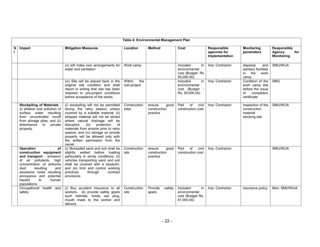
45. Stockpiling of Materials (Storage of topsoil, fill material, gravel, aggregates, and other construction materials). Potential environmental impacts include (i) siltation and pollution of surface water resulting from uncontrolled runoff from storage piles; and (ii) disturbance to private property.
46. Mitigation measures include: (i) stockpiling shall not be permitted during the rainy season unless covered by a suitable material; (ii) stripped material shall not be stored where natural drainage will be disrupted; (iii) protection of materials from erosion prior to rainy season; and (iv) storage on private property will be allowed only if written permission is obtained from the owner or authorized lessee.
47. Operation of construction equipment and transport: As no heavy construction equipments are needed, the subproject activities will not contribute major air pollution and excessive noise. However airborne dust particles due to construction materials during transportation and stockpiling may result in deposition and possible damage to vegetation, crops, and water resources.
48. Mitigation measures include: (i) stockpiled sand and soil shall be slightly wetted before loading particularly in windy conditions; (ii) vehicles transporting sand and soil shall be covered with a tarpaulin; and (iii) limit and control working practices through contract provisions such as: (a) avoid noise-generating activities at night; (b) consult with local community to inform them of the nature, duration, and likely effects of the construction work; (c) schedule work during dry season
49. Occupational health and safety: In the construction sites, there will be movement of local peoples. Despite precautions, possibility of accidents could not be ruled out completely as many types of equipment will be under operation. Hence, construction activities may pose safety concern to local peoples as well as workers. Although the health and safety will be major concern during the construction stage, magnitude of the impacts has been evaluated as low since provision of health and safety measures are mandatory in any of the construction contracts and due to small scale of construction. The extent will be site specific and duration will be of short term.
50. Accidental insurance will be covered for all construction workers and staff. An amount of Rs. 61,000.00 has been allocated for the buying the accident insurance policy of the workers. This cost shall be covered from the environmental management cost. In order to minimize the unwanted accidents and possible effects of dust and gaseous emission to construction workers, the project will ensure adequate safety measures such as provision of helmets, masks, ear

- 16 -
plugs, road signs, warning signals etc. The provision of the safety gears also will be borne environmental management cost.
51. Temporary closure of irrigation system. The construction activity in the canal system is likely to disturb the supply of the irrigation water for a relatively short period.
52. Mitigation Measures: The construction activities will be planned in consultation with the WUA members. The headworks construction will be carried out during the dry season and the alternative measures will be made to keep the canal in running conditions if the construction activities will be carried out during the canal operation time. Flexible hosing and/or diversion canals will be used to supply water to affected users. Cost of alternative arrangement for supplying the water will be part of the civil construction cost.
Environmental Problems Resulting from Subproject Operations
53. Changes in Groundwater Hydrology. The application of the irrigation water in the field is likely to recharge the groundwater of the subproject area vicinity and the groundwater table will rise in general. But any substantial change in groundwater hydrology is unlikely due to the proposed project because the subproject area is already receiving the irrigation water. The proposed subproject is rehabilitation only. Hence the impact is considered of low magnitude, local in extent and long term in duration.
54. Mosquito Breeding. In an irrigation project, the water is flooded in the field especially during the monsoon season, which could be the breeding ground for the mosquito, a carrier of diseases. But the proposed subproject is the rehabilitation of the existing irrigation system, which is already in operation. The proposed subproject is not going to have any additional effect on the environment. Hence the impact is considered of low magnitude, local in extent and long term in duration.
55. Hazards associated with the Use of Toxic Chemicals. Pesticides are the toxic chemicals that would be used in the agricultural crops whenever crops are infested by the insects. From the focused group discussion with the farmers, they seemed to be aware of the toxicity of the pesticides. Use of pesticides in the subproject area is minimum. Farmers need some IPM (integrated pest management) training so as to train the farmers in pest management without the use of pesticides. With this background, it could be assumed that impact associated with the pesticides (toxic chemicals) will be of low magnitude, local in extent and long term in duration.
56. Hazards associated with the Use of Mineral Fertilizer. The farmers have been using chemical fertilizers in the crops. But the quantity of usage is less than the recommended dose for the crops. The subproject intends to carry out training in the crops cultivation to increase the crops yield. Hence the use of chemical fertilizers is going to be increased with the subproject implementation. But given the proper training programs, the application dose will be optimum for the crops and it would not create any hazard as such. Hence the impact is considered of low magnitude, local in extent and long term in duration.

- 17 -
Realization of Enhancement Potentials
57. Employment Opportunity to the Local People. The construction of the subproject would require both skilled and unskilled labour. Semi skilled and unskilled labours are available in the subproject area as well as its vicinity. The subproject would provide employment opportunity to the local people. In addition, the farmers will have to make their contribution, which could be in kind and cash. The farmers preferred to make contribution by providing labour.
58. Livelihood Programs for Landless Households. There are 50 ultra poor/landless households in the subproject area who work as tenants for other households who own the land. The proposed subproject intends to enhance the economic condition of these households by implementing different livelihood programs.
59. Feasibility of Cooperatives. The existing irrigation system is being operated and maintained by the water users association. They have defined rules and regulations, which are followed by all the members. The rules and regulations are socially binding. The proposed CMIASP intends to implement a number of institutional development activities in strengthening capacities of the WUAs in agricultural production, and poverty alleviation of the project area. The WUA will have the key role to play in these activities. For the project implementation, a coordination committee is planned to be formed. The WUA could also function as the cooperatives to support the farmers in terms of making timely availability of agricultural inputs, marketing of the agricultural production, facilitating the micro credits.
VI. ANALYSIS OF ALTERNATIVES
60. The proposed diversion structure for the intake is an overflow type of Concrete weir. On the consultation with the WUA members, the headworks has been proposed at the same traditional diversion point. Since the irrigation system is the traditional system, canals already exist and there are no alternative alignments for them.

- 18 -
VII. INSTITUTIONAL ARRANGEMENTS
61. Institutional requirements. Nepal has an established legal and policy framework for environmental safeguarding in relation to projects. Environmental protection is overseen by the Ministry of Environment, Science and Technology (MoEST). It holds overall responsibility for environmental policy. The principal legislation for environmental safeguarding is the 1997 Environmental Protection Act (EPA) and its rules 1997, amended in 1999 and amendment 2008. Implementation of the EPA is the responsibility of the MoEST and the sectoral ministries. For those projects having insignificant environmental impacts, the responsibility of undertaking and approving IEEs and implementing the subsequent environmental monitoring plan (EMP) are delegated to the concerned sectoral ministries. The DOI is under the MOWR. Both DOI and MOWR have environmental sections that liaise with each other. The Environmental Section within DOI was established in 1988 and is located within the Surface Water Irrigation Division (SWID).
62. The revised Schedule 1 of Section 2 of the EPR stipulates the environmental assessment requirements for irrigation schemes. It stipulates that an initial environmental examination (IEEs) is required for the rehabilitation of irrigation schemes which has new headworks or change in the main canal alignment. Since the proposed sub project is a simple rehabilitation of the existing FMIS, a formal IEE in accordance with EPR amendment 2008 will not be required.
63. Institutional arrangements and responsibilities. At the DOI headquarters level, a central project management office (CPMO) has been set up with class-I engineer as full time project director, and will be responsible for overall environmental management, under technical support and guidance from Environmental Section in SWID. At the regional level, regional project support unit (RPSU) has been established with director of the Regional Irrigation Directorate as project manager of each region and will be responsible for day-to-day implementation of the Project. RPSU will have an assigned staff to manage environmental activities with the assistance of the consultants. At the field level, subproject management unit (SMU) has been established in each division headed by the chief of the irrigation development division/ subdivision (IDD/IDSD), which will undertake field operations including environmental planning and monitoring under supervision by RPSU. Specific institutional responsibilities during the subproject implementation cycle are stipulated as below.
Table 3: Institutional Responsibilities for Environmental Management Subproject Stage Responsible Organization Responsibilities
Overall ISPM Consultants Support capacity development of environmental planning, monitoring, and management
EB is SWID Guidance for environmental planning, monitoring, and mitigation
MEQCB in PDMED Management of monitoring and evaluation data Screening RPSU/SMU Screen the project results in light of
environmental and other criteris Planning RPSU/SMU/firms
1 Prepare IEE (included in SIP), minimize
avoidable losses, incorporate mitigation measures, and prepare EMP
CPMO-EB in SWD Endorse IEE and SIP Subproject Appraisal Subcommittee Approve IEE and SIP Ministry of Water Resources Approve IEE (which fall under schedule 1,
- 19 -
section 2 of EPR 1997, amendment, 2008) WUA formation RPSU/SMU/NGOs/COs Strengthen WUA including monitoring capacities Detailed Design RPSU/SMU/firms Assist in preparing RP, incorporate EMP into
engineering design and specifications Construction Contractor Implement required environmental measures
RPSU/SMU/firms Supervise contractor implementation of environmental measures
Agriculture and social support
RPSU/SMU/firms/NGOs Implement specific environmental mitigation measures incorporated in the agriculture and social development plan.
Operational DOI provide budget to undertake annual monitoring and audit
RPSU/SMU/NGOs (during Project) Carry-out annual performance audit of completed schemes. Support additional mitigation measures as necessary.
RID/IDD/IDSD/DDC/DADO (after Project)
Same as above
WUAs Monitor agriculture practice and impacts and report them to SMU.
Notes: DB=Design Branch; EB=Environmental Branch; MEQCB=Monitoring, Evaluation, and Quality Control Branch; PDMED=Planning, Design, Monitoring and Evaluation Division; SWD=Surface Water Division

- 20 -
VIII. ENVIRONMENTAL MANAGEMENT PLAN
64. The Environmental Management Plan (EMP) is prepared to guide implementation of mitigation measures and monitoring requirements. It includes institution and their roles, environmental management activities, environmental management organizational structure and budget for mitigation measures.
65. Essentially, it will be put into operation through data collection at subproject level by SMU with the engagement of private firms as necessary and/or WUA, monitored and supervised by RPSU through regular management review and field confirmation, and processing and analysis by Monitoring and Evaluation Branch of DOI in coordination with DOA. Environmental data will be shared with Environment Division. Monitoring costs have been incorporated into the design of the PPME system for the project. The findings of the monitoring activities will be incorporated in the regular PPME reports prepared by CPMO with the assistance of the consultants engaged under institutional strengthening and project management, and submitted to ADB.
66. Framework for implementing environmental management plan is shown by Table 4.

- 21 -
Table 4: Environmental Management Plan
Sl
Impact Mitigation Measures Location Method Cost Responsible agencies for Implementation
Monitoring parameters
Responsible Agency for Monitoring
1 Environmental Problem due project location
2 Environmental Problem related to project design Watershed erosion Provide permanent headworks Design
Office Include in det. design
No cost Design team
provision of permanent headworks
ISPMC
Canal management Prepare subproject specific water management plan and O & M Plan.
Design Office
included in det. design
No cost Design team
Prepare site specific water management plan
ISPMC
Passageway Provide passageway structures Design Office
Include in det. design
No cost Design team
provide passage as agreed with the farmers
ISPMC
Hazards associated with the use of toxic chemicals
Avoid using pesticide to the extent possible. Use IPM technique to control pest
Design Office
Include in Agriculture Development Plan.
No cost Design team
Include IPM training package in Agriculture Development Plan (ADP.)
ISPMC
3 Environmental Problem related to construction stage Excavation (i)confine operations in the dry
season; (ii) use of silt traps; (iii) spoils shall be disposed of at the designated locations
Within the sub-project
designate the spoil disposal area
Part of civil construction cost
Imp: Contractor Mon: SMU/WUA
spoil disposal sites
SMU/WUA
Quarry sites Work Camp Location and
Operation: (i) temporary air and noise pollution from machine operation; (ii) water pollution from storage and use of fuel, oils, solvents, and lubricants; (iii) unhygienic conditions from laborers; (iv) disturbance to wildlife
(i) work camp will be located away from the settlement area. (ii) no trees shall be cut and removal of vegetation shall be minimized (iii) used oil and lubricants shall be recovered and reused or removed from site. (iv) work camp will not be located in wildlife habitats, restriction and control of wildlife harassment, illegal hunting and poaching
Within the sub-project
Part of civil construction cost
Contractor
Location of the work camp
SMU/WUA
- 22 -
Table 4: Environmental Management Plan
Sl
Impact Mitigation Measures Location Method Cost Responsible agencies for Implementation
Monitoring parameters
Responsible Agency for Monitoring
(v) will make own arrangements for water and sanitation
Work camp Included in environmental cost (Budget: Rs 50,000.00)
Imp: Contractor
disposal and sanitary facilities in the work camp
SMU/WUA
(vi) Site will be placed back in the original site condition and shall report in writing that site has been restored to pre-project conditions before acceptance of the works.
Within the sub-project
Included in environmental cost (Budget : Rs, 50,000.00)
Imp: Contractor
Condition of the work camp site before the issue of completion certificate
SMU
Stockpiling of Materials : (i) siltation and pollution of surface water resulting from uncontrolled runoff from storage piles; and (ii) disturbance to private property.
(i) stockpiling will not be permitted during the rainy season unless covered by a suitable material; (ii) stripped material will not be stored where natural drainage will be disrupted; (iii) protection of materials from erosion prior to rainy season; and (iv) storage on private property will be allowed only with the written permission from the owner.
Construction sites
ensure good construction practice
Part of civil construction cost
Imp: Contractor
Inspection of the construction material stocking site.
SMU/WUA
Operation of construction equipment and transport : emission of air pollutants, high concentration of airborne dust resulting and excessive noise resulting annoyance and potential hazard to human populations
(i) Stockpiled sand and soil shall be slightly wetted before loading particularly in windy conditions; (ii) vehicles transporting sand and soil shall be covered with a tarpaulin; and (iii) limit and control working practices through contract provisions.
Construction site
ensure good construction practice
Part of civil construction cost
Imp: Contractor
SMU/WUA
Occupational health and safety
(i) Buy accident insurance to all workers. (ii) provide safety gears such helmets, boots, ear plug, mouth mask to the worker and labours
Construction site
Provide safety gears
Included in environmental cost (Budget Rs. 61,000.00)
Imp: Contractor
insurance policy Mon: SMU/WUA

- 23 -
Table 4: Environmental Management Plan
Sl
Impact Mitigation Measures Location Method Cost Responsible agencies for Implementation
Monitoring parameters
Responsible Agency for Monitoring
Temporary closure of irrigation system
Plan the headworks construction during dry season
Headworks No cost Imp: Contractor
Construction plan
Mon: SMU/WUA
Make alternative arrangement to keep the canal running
Canals Part of civil construction cost
Imp: Contractor
Enquiry on canal closure
Mon: SMU/WUA
Environmental Problems Resulting from Project Operations Hazards associated with
the use of toxic chemicals Avoid using pesticide to the extent possible. Use IPM technique to control pest
Command area
Pest control by IPM
No cost Imp: Farmers
Use of pesticide in the crops
Mon: DADO
Hazards associated with the use of mineral fertilizer
Use recommended dose of inorganic fertilizers
Command area
Application of fertilizers
No cost Imp: Farmers
Use of chemical fertilizer in the crops
Mon: DADO
Realization of Enhancement Potentials Employment to the local
people Provide employment to local people in priority
Within Sub project area
Hire local labour to the extent possible
No cost Imp: Contractor
Payroll of contractor
Mon: WUA
Livelihood programs for landless households
Provide Livelihood enhancement Program (LEP) training to the targeted people
Within sub project area
Training Include in LEP cost
Imp: SMU
Training on LEP Mon: WUA
Feasibility of cooperatives Provide institutional development training
Within sub project area
Training Include in Institutional development plan cost.
Imp: SMU
Training on Institutional development training
Mon: WUA

- 24 -
IX. PUBLIC CONSULTATION AND DISCLOSURE
67. This IEE report has been prepared in close consultation with WUA members and lead farmers who participated in the walk through survey. The walk through survey was carried out from 7th to 10th February 2009 and the WUA endorsement meeting was conducted on 10th February 2009. The participants from WUA were Mr. Mukesh Kumar Yadav (Chairman), Mr. Mohan Yadav (Vice Chairman), Mr. Ram Prasad Yadav (Treasurer) and Mr. Ram Kewal Yadav (Member). The lead farmers were represented by Mr. Ram Darshan Yadav and Mr. Mahesha Ray. The list of WUA members is presented below:
1. Mr. Mukesh Kumar Yadav, Chairman 2. Mr. Mohan Yadav, Vice Chairman 3. Mr. Ram Prasad Yadav, Treasurer 4. Mr. Shyam Kumar Yadav, Secretary 5. Mr. Laxman Yadav, Vice-Secretary 6. Mr. Ram Kewal Yadav, Member 7. Mr. Damodar Shah, Member 8. Mr. Jogindra Yadav, Member 9. Ms. Ram Pukari Devi Yadav, Member 10. Ms. Sharmila Devi Paswan, Member 11. Ms. Parmila Devi Yadav, Member
68. The impact and proposed mitigation measures were discussed and agreed with farmers during the SIP endorsement by WUA general body meeting.
- 25 -
X. FINDINGS AND RECOMMENDATIONS
69. The principal findings are that the Subproject provides for inherently environmentally friendly irrigation interventions and contributes to significantly improved living conditions through (i) community emphasis on subproject design and implementation, (ii) extensive technical support in eliciting sustainable practices in irrigated agriculture and (iii) addressing institutional needs for sustained and equitable O&M.
70. The identified adverse environmental impacts will be addressed through proper planning, design, implementation, and O&M while incorporating identified mitigation measures. The screening process carried out in the IEE has not identified any significant negative environmental impacts likely to be caused by the Project. Environmental issues were considered throughout development of the Project and necessary changes were made to the designs to reduce or avoid impacts. Potential negative impacts associated with construction activities can be mitigated by the application of standard health, safety, and environmental clauses in contract documents, close supervision, and close attention to transparency in tendering, and to quality control and supervision on site. Mitigation measures for other impacts are provided in detail in the IEE.

- 26 -
XI. CONCLUSION
71. The project is not expected to give rise to any significant negative environmental impacts, and therefore does not require an ADB Environmental Impact Assessment.
72. The proposed subproject is rehabilitation of existing irrigation system, which is already in operation. Hence, the environmental impact during the operation phase will not be very much different than the existing situation. Rather the existing system lacks basic structures like intake, cross drains, the proposed intervention will be providing basic civil engineering structures for the operation of the canal. From the proposed intervention some adverse impacts of low magnitude have been identified during the construction stage but they are of short-term duration and could be easily mitigated. The proposed intervention will provide round year irrigation to the entire command area Taking into consideration the adverse impact of low magnitude and extensive positive impacts, this subproject is recommended for implementation on the environmental perspectives. Mitigation of minor adverse environmental impacts can be carried out as an integral part of the Subproject, during both the detailed design and implementation stages. Appropriate measures will be included in the tender documents for the civil works.

- 27 -
ANNEX 1: DETAILS OF PROPOSED INTERVENTION IN THE SUBPROJECT
A. Main Canal 1
Item No
Chainage & WayPoints
Structure Condition Severity of the Problems on System Operation
Solution (Priority: H, M, or L)
Sketch
From To 1 0+000
Headworks
2 0+026
VRB (5M) Road crosses the canal
Road Crossing VRB (H)
3 0+779
VRB (5M)
Road crosses the canal
Road Crossing VRB (H)
4 1+054
Start of Main canal 2
5 1+206
Existing Canal End
6 1+283
Branch Canal
Diversion for command area
Fulfill demand of Command area
Branch L/S
7 1+748
Branch Canal Diversion for command area
Fulfill demand of Command area
Branch L/S
9 2+548
Pipe Culvert (5m)
Road Crosses the Canal
Road Crossing Pipe Culvert (5m)
10 2+998
Pipe Culvert ( Existing)
Road Crosses the Canal
Road Crossing Pipe Culvert

- 28 -
Main Canal 2 (1+054 of Main Canal 1)
Item No
Chainage & WayPoints
Structure Condition Severity of the Problems on System Operation
Solution (Priority: H, M, or L)
Sketch
From To 11 3+016
Branch L4 Start
Diversion for command area
Fulfill demand of Command area
Branch L/S
12 3+378
Branch Canal
Diversion for command area
Fulfill demand of Command area
Branch L/S
13 4+197
Pipe Culvert, Branch Canal
Road Crosses the canal
Road Crossing VRB Pipe Culvert and Branch Canal
14 4+568
Pipe Culvert (7.5m), Hulaki road
Road Crosses the canal
Road Crossing Pipe Culvert
15 4+886
End of Main canal 1
Item No
Chainage & WayPoints
Structure Condition Severity of the Problems on System Operation
Solution (Priority: H, M, or L)
Sketch
From To 1 0+000 Start of Main canal 2
2 0+360
Branch canal start
Diversion for command area
Fulfill demand of Command area
Branch Canal
3 0+727
Pipe Culvert (5m), Branch canal start
Road Crosses the canal
Road Crossing VRB Pipe Culvert (5m), Branch Canal
4 0+952
VRB (3m)
Road Crosses the canal
Road Crossing Pipe Culvert (5m)
5 1+168
Branch Canal Srart
Diversion for command area
Fulfill demand of Command area
Branch Canal

- 29 -
Item No
Chainage & WayPoints
Structure Condition Severity of the Problems on System Operation
Solution (Priority: H, M, or L)
Sketch
From To 6 1+258
VRB(5m)
Road Crosses the canal
Road Crossing VRB (5m)
7 1+319
VRB (5m)
Road Crosses the canal
Road Crossing VRB (5m)
8 1+426
VRB (5m)
Road Crosses the canal
Road Crossing VRB (5m)
9 1+588
VRB (5m)
Road Crosses the canal
Road Crossing VRB (5m)
10 1+804
VRB (5m)
Road Crosses the canal
Road Crossing VRB (5m)
11 2+017
Outlet, VRB (6m)
No Structure, uncontrolled
No controlled outlet causing bank erosions
Outlet (H) and VRB (6m)
12 2+265
VRB (3m)
Road Crosses the canal
Road Crossing VRB (5m)
13 3+289
Branch canal Start
Diversion for command area
Fulfill demand of Command area
Branch Canal
14 3+680
End of Main canal 2