3.3.1 E NVIRONMENTAL SETTING
30
3.3 BIOLOGICAL RESOURCES This section of the EIR evaluates individual resource and cumulative impacts to biological resources with implementation of the proposed project. The analysis of biological resources presented in this section is based on a Biological Resources Assessment prepared by Zander Associates in 2001 and updated in 2005, as well as a Forest Management Plan that was prepared by Staub Forestry and Environmental Consulting in June 2001 and updated in 2008. The biological assessment and Forest Management Plan are included in Appendix C. 3.3.1 ENVIRONMENTAL SETTING REGIONAL SETTING The project site is located within the County of Monterey, California in the Toro Area Plan planning area. As defined by the Monterey County General Plan, there are eight major plant communities found within the County including fresh and saltwater marshes, riparian woodland, grassland, coastal scrub, chaparral, broadleaf evergreen, coniferous forest and mixed conifer forest. Coastal strand, wetlands, riparian woodland, and maritime chaparral are all considered severely limited or threatened. Monterey County’s wildlife communities are varied and abundant. Some of the dominating communities consist of mountain lion, bobcat, coyote, birds of prey, boar, and seabirds. LOCAL SETTING The 344-acre project site consists primarily of grazing land on rolling terrain that ranges in elevation from about 340 to 1,020 feet above mean sea level. There are several seasonal drainage courses that originate in the hills on the project site and drain downslope to the south, east and west off the property. A sandstone escarpment or badland with severely eroded slopes and minimal vegetation is located at the northern property boundary, near the northern corner of proposed Lot #9. Several smaller escarpments are found near ridges in the northeastern portion of the property. There are no homes or other building structures currently on the site. BIOLOGICAL COMMUNITIES Three vegetation communities are located on the project site: annual grassland, coast live oak woodland/savanna, and chamise chaparral as shown in Figure 3.3-1, Biological Resources Map. In addition to the three vegetative communities, several intermittent drainages were discovered. Annual Grassland Annual grasslands are found throughout the project site and are characterized by a mixture of native perennial species, as well as introduced annual species, all of which are heavily grazed by cattle. The primary native perennial species observed scattered throughout the grassland is purple needlegrass (Nasella pulchra). Common introduced grass species County of Monterey Harper Canyon/Encina Hills Subdivision October 2008 Draft Environmental Impact Report 3.3-1
Transcript of 3.3.1 E NVIRONMENTAL SETTING
3.3 BIOLOGICAL RESOURCES
This section of the EIR evaluates individual resource and cumulative impacts to biological resources with implementation of the proposed project. The analysis of biological resources presented in this section is based on a Biological Resources Assessment prepared by Zander Associates in 2001 and updated in 2005, as well as a Forest Management Plan that was prepared by Staub Forestry and Environmental Consulting in June 2001 and updated in 2008. The biological assessment and Forest Management Plan are included in Appendix C.
3.3.1 ENVIRONMENTAL SETTING
REGIONAL SETTING
The project site is located within the County of Monterey, California in the Toro Area Plan planning area. As defined by the Monterey County General Plan, there are eight major plant communities found within the County including fresh and saltwater marshes, riparian woodland, grassland, coastal scrub, chaparral, broadleaf evergreen, coniferous forest and mixed conifer forest. Coastal strand, wetlands, riparian woodland, and maritime chaparral are all considered severely limited or threatened. Monterey County’s wildlife communities are varied and abundant. Some of the dominating communities consist of mountain lion, bobcat, coyote, birds of prey, boar, and seabirds.
LOCAL SETTING
The 344-acre project site consists primarily of grazing land on rolling terrain that ranges in elevation from about 340 to 1,020 feet above mean sea level. There are several seasonal drainage courses that originate in the hills on the project site and drain downslope to the south, east and west off the property. A sandstone escarpment or badland with severely eroded slopes and minimal vegetation is located at the northern property boundary, near the northern corner of proposed Lot #9. Several smaller escarpments are found near ridges in the northeastern portion of the property. There are no homes or other building structures currently on the site.
BIOLOGICAL COMMUNITIES
Three vegetation communities are located on the project site: annual grassland, coast live oak woodland/savanna, and chamise chaparral as shown in Figure 3.3-1, Biological Resources Map. In addition to the three vegetative communities, several intermittent drainages were discovered.
Annual Grassland
Annual grasslands are found throughout the project site and are characterized by a mixture of native perennial species, as well as introduced annual species, all of which are heavily grazed by cattle. The primary native perennial species observed scattered throughout the grassland is purple needlegrass (Nasella pulchra). Common introduced grass species
County of Monterey Harper Canyon/Encina Hills Subdivision October 2008 Draft Environmental Impact Report
3.3-1
3.3 BIOLOGICAL RESOURCES
observed include slender wild oats (Avena barbata), ripgut brome (Bromus diandrus), soft chess (Bromus hordeaceus), and rattail fescue (Vulpia myuros).
Annual grasslands often provide habitat for a variety of native wildflowers that typically bloom in the spring. Some of the wildflower species that were in bloom and identifiable onsite include: footsteps of spring (Sanicula arctopoides), Johnny jump-up (Viola pedunculata), and California gilia (Gilia achilleifolia). The dominant flowering herb present within the grassland during the survey was the non-native long-beaked filaree (Erodium botrys), which is indicative of the extensive grazing currently occurring on the project site.
Annual grasslands provide foraging habitat for small mammals, which in turn serve as prey for a variety of other animals, including snakes, raptors (“birds of prey”) and coyotes (Canis latrans). Numerous invertebrate species, many of which provide a food source for larger animals such as lizards, birds and some small mammals, can also be found within annual grassland communities.
Coast Live Oak Woodland and Savanna
The oak woodland communities of Monterey County are dominated by open to nearly closed canopies of coast live oaks (Quercus agrifolia) with grass or shrub understories. Oak savannas are transitional vegetative communities between woodlands and grassland with trees more widely spaced and the understory dominated by grassland. On the project site, oak woodlands occupy the more mesic (moist) north-facing slopes and canyon bottoms and the oak savanna occupy a drier, east-facing slope, near the ridgetop.
The understory species of oak woodlands varies depending upon local conditions, such as moisture availability and soil type. The understory in the oak savanna consists of species common to the annual grassland habitat but may include additional wildflower species not found in the open grasslands. Common oak woodland understory species observed on the project site include poison oak (Toxicodendron diversilobum), toyon (Heteromeles arbutifolia), and California coffeeberry (Rhamnus californica). The species in the understory changes slightly where the oak woodland transitions to chamise chaparral higher on the slopes to include some chamise chaparral species.
Oak woodlands and oak savannas provide habitat for a variety of wildlife. The oak trees provide suitable nesting sites and cover for birds and many mammals. Woody debris and duff in the woodland understory provide foraging areas for small mammals and microclimates suitable for amphibians and reptiles. Acorns are a valuable food source for many animal species, including the California quail (Lophortyx californicus), western gray squirrel (Scirus griseus) and black-tailed deer (Odocoileus hemionus). Other representative animal species of oak dominated woodlands include the arboreal salamander (Aneides lugubris), western screech owl (Otus kennicotti), scrub jay (Aphelocoma corulescens), and Virginia opossum (Didelphis virginianus).
Harper Canyon/Encina Hills Subdivision County of Monterey Draft Environmental Impact Report October 2008
3.3-2

3.3 BIOLOGICAL RESOURCES
Insert Figure 3.3-1 (Biological Resources Map)
County of Monterey Harper Canyon/Encina Hills Subdivision October 2008 Draft Environmental Impact Report
3.3-3

3.3 BIOLOGICAL RESOURCES
This page intentionally left blank.
Harper Canyon/Encina Hills Subdivision County of Monterey Draft Environmental Impact Report October 2008
3.3-4
3.3 BIOLOGICAL RESOURCES
Chamise Chaparral
Chamise chaparral communities are characterized by moderate- to low-growing evergreen and drought tolerant shrubs that have adapted to shallow soils. The dominant species within this community is the hard-leaved shrub, chamise (Adenostoma fasciculatum). Associated plant species include the toyon (Heteromeles arbutifolia), sticky monkey flower (Mimus aurantiacus), Manzanita (Arctostaphylos spp), ceanothus (Ceanothus spp), redberry (Rhamnus crocea), California sage brush (Atemisisa california), and a few scattered coyote brush (Baccharis pilularis). On the project site, Manzanita species occur in clusters at several locations throughout the chamise chaparral. Chamise chaparral occurs predominately on drier, wind exposed sites near the tops of the ridges or on steep slopes with sandy, mudstone or shale soils. The Toro (or Monterey) manzanita (Arctostaphylos montereyensis) and Monterey ceanothus (Ceanothus cuneatus var. rigidus) are two special status plant species associated with chamise chaparral.
Chamise chaparral provides cover and nesting habitat for a variety of animals. The sandy soils typically associated with this community also provide areas for wildlife denning and nesting. Animal species common to chamise chaparral habitat include western fence lizard (Sceloporus occidentalis), western rattlesnake (Crotalus viridis), California quail (Callipepla california), brush rabbit (Sylvilagus bachmani), and gray fox (Urocyon cinereoargentus).
Drainages
There are portions of several drainages and tributaries to drainages that originate on the project site and carry flows off-site. These drainages appear to be ephemeral, carrying flow only in response to winter storms. In general, the channels are cobble- or soil-lined and are devoid of in-channel vegetation. Some of the channels are deeply incised. Oak woodland vegetation is primarily associated with the drainages; classic riparian (stream-related) vegetation is generally absent from these areas. Most of the drainages on the project site are tributary to El Toro Creek, which drains to the Salinas River.
Wildlife habitat in these drainages does not vary substantially from that previously described for oak woodland or annual grassland habitat. The channels can provide movement corridors for amphibians when water is present and for other animals throughout the year.
SPECIAL STATUS SPECIES
In general, special-status species include plants and wildlife that are: listed, proposed for listing, or candidates for listing as threatened or endangered by the U.S. Fish and Wildlife Service (USFWS); those considered “Species of Concern” by the USFWS; those listed or proposed for listing as rare, threatened or endangered by the California Department of Fish and Game (CDFG); plants occurring on lists 1B or 2 of the California Native Plant Society’s
County of Monterey Harper Canyon/Encina Hills Subdivision October 2008 Draft Environmental Impact Report
3.3-5
3.3 BIOLOGICAL RESOURCES
Inventory of Rare and Endangered Vascular Plants of California (1994); and animals designated as “Species of Special Concern” by CDFG.
The U.S. Fish and Wildlife Service (USFWS), California Natural Diversity Database (CNDDB) and California Native Plant Society (CNPS) inventory, identify special status species that may be affected by projects in Monterey County. Listed special status plant and wildlife species that will possibly or will likely occur within the project site are listed in Tables 3.3-1 and 3.3-2, respectively. Figure 3.3-1 shows occurrences of special-status species listed in the CNDDB within the project site. Species listed as being unlikely to occur within the project site are considered to be beyond their known range or to have low habitat suitability for reproduction, cover, and/or foraging.
Listed and Special Status Plants
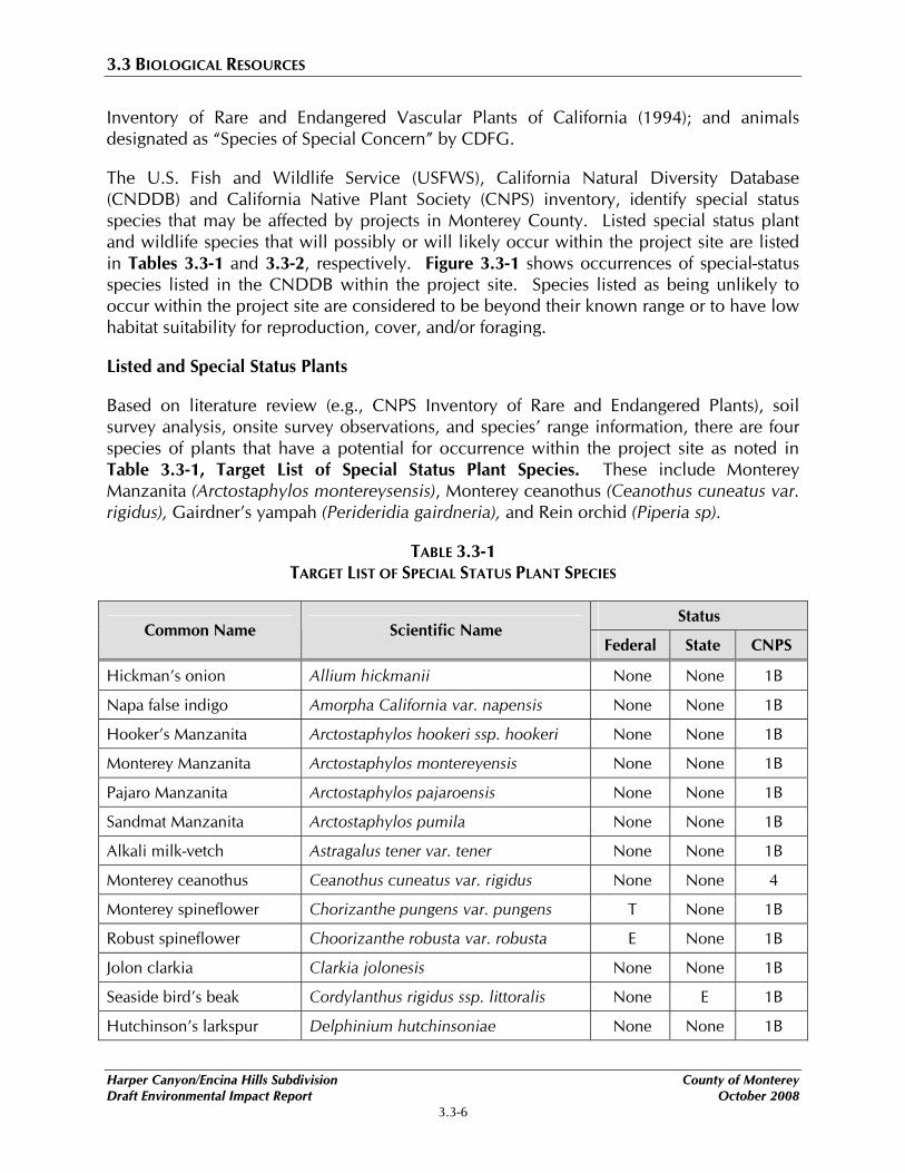
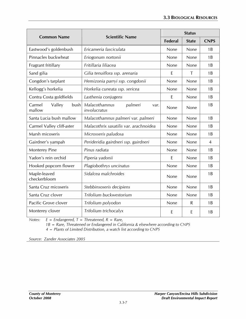
Based on literature review (e.g., CNPS Inventory of Rare and Endangered Plants), soil survey analysis, onsite survey observations, and species’ range information, there are four species of plants that have a potential for occurrence within the project site as noted in Table 3.3-1, Target List of Special Status Plant Species. These include Monterey Manzanita (Arctostaphylos montereysensis), Monterey ceanothus (Ceanothus cuneatus var. rigidus), Gairdner’s yampah (Perideridia gairdneria), and Rein orchid (Piperia sp).
TABLE 3.3-1 TARGET LIST OF SPECIAL STATUS PLANT SPECIES
Status Common Name Scientific Name
Federal State CNPS
Hickman’s onion Allium hickmanii None None 1B
Napa false indigo Amorpha California var. napensis None None 1B
Hooker’s Manzanita Arctostaphylos hookeri ssp. hookeri None None 1B
Monterey Manzanita Arctostaphylos montereyensis None None 1B
Pajaro Manzanita Arctostaphylos pajaroensis None None 1B
Sandmat Manzanita Arctostaphylos pumila None None 1B
Alkali milk-vetch Astragalus tener var. tener None None 1B
Monterey ceanothus Ceanothus cuneatus var. rigidus None None 4
Monterey spineflower Chorizanthe pungens var. pungens T None 1B
Robust spineflower Choorizanthe robusta var. robusta E None 1B
Jolon clarkia Clarkia jolonesis None None 1B
Seaside bird’s beak Cordylanthus rigidus ssp. littoralis None E 1B
Hutchinson’s larkspur Delphinium hutchinsoniae None None 1B
Harper Canyon/Encina Hills Subdivision County of Monterey Draft Environmental Impact Report October 2008
3.3-6
3.3 BIOLOGICAL RESOURCES
Status Common Name Scientific Name
Federal State CNPS
Eastwood’s goldenbush Ericameria fasciculata None None 1B
Pinnacles buckwheat Eriogonum nortonii None None 1B
Fragrant fritillary Fritillaria liliacea None None 1B
Sand gilia Gilia tenuiflora ssp. arenaria E T 1B
Congdon’s tarplant Hemizonia parryi ssp. congdonii None None 1B
Kellogg’s horkelia Horkelia cuneata ssp. sericea None None 1B
Contra Costa goldfields Lasthenia conjugens E None 1B
Carmel Valley bush mallow
Malacothamnus palmeri var. involucratus None None 1B
Santa Lucia bush mallow Malacothamnus palmeri var. palmeri None None 1B
Carmel Valley cliff-aster Malacothrix saxatilis var. arachnoidea None None 1B
Marsh micoseris Microsseris paludosa None None 1B
Gairdner’s yampah Perideridia gairdneri ssp. gairdneri None None 4
Monterey Pine Pinus radiata None None 1B
Yadon’s rein orchid Piperia yadonii E None 1B
Hooked popcorn flower Plagiobothrys uncinatus None None 1B
Maple-leaved checkerbloom
Sidalcea malchroides None None 1B
Santa Cruz micoseris Stebbinsoseris decipiens None None 1B
Santa Cruz clover Trifolium buckwestorium None None 1B
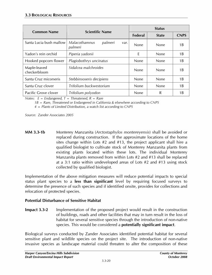
Pacific Grove clover Trifolium polyodon None R 1B
Monterey clover Trifolium trichocalyx E E 1B
Notes: E = Endangered, T = Threatened, R = Rare, 1B = Rare, Threatened or Endangered in California & elsewhere according to CNPS
4 = Plants of Limited Distribution, a watch list according to CNPS
Source: Zander Associates 2005
County of Monterey Harper Canyon/Encina Hills Subdivision October 2008 Draft Environmental Impact Report
3.3-7
3.3 BIOLOGICAL RESOURCES
Monterey ceanothus (Ceanothus cuneatus var. rigidus)
Monterey ceanothus is listed as “Plants of Limited Distribution (on a watch list)” with the California Native Plant Society. This species of ceanothus is frequently found within chaparral, coastal scrub and closed-cone coniferous forest. It is characterized as an evergreen perennial shrub that is identifiable throughout the year. Monterey ceanothus was identified within the “Remainder Parcel” at the project site.
Monterey manzanita (Arctostaphylos montereyensis)
Monterey Manzanita is listed as “Rare, Threatened or Endangered in California” with the California Native Plant Society. This is a winter blooming evergreen shrub that is found in sandy soils within chaparral cismontane woodland, and coastal scrub habitats in Monterey County. Monterey Manzanita was identified within the eastern portion of the project site and within the “Remainder Parcel” at the project site.
Gairdner’s yampah (Perideridea gairdneri ssp. gairdneri)
Gairdner’s yampah is listed as “Plants of Limited Distribution (on a watch list)” with the California Native Plant Society. This species blooms June through October and is common to chaparral, broad-leaved upland forests and valley foothills and grasslands habitats under mesic conditions. Gairdner’s yampah was identified within the “Remainder Parcel” at the project site.
Rein orchid (Piperia ssp.)
Yadon’s rein orchid is a federally and state listed Endangered species. The Piperia species are generally only visible in the early spring and identifiable to species in the summer and prefer poorly drained sandy soils of closed-cone coniferous forest, chaparral and coastal scrub habitats. The individual unidentified rein orchid (Piperia ssp.) was observed along the northwestern property boundary within Lot #3 in 2001, but was not identified by Zander Associates during the survey conducted in the Fall of 2005. A second unidentified rein orchid was observed within chaparral habitat on the “Remainder parcel.” According to Zander Associates, the length of the long spur observed on the wilted flower that remained on the plant made it possible to determine that this species was not the federally Endangered Piperia ssp.
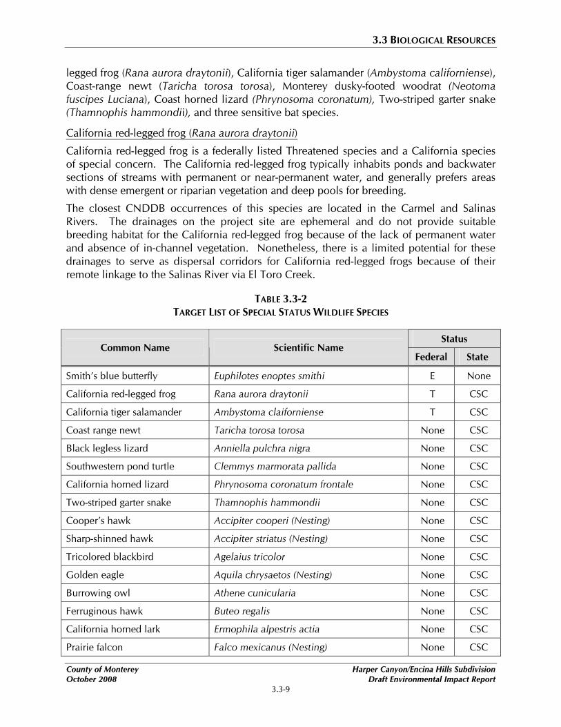
Listed and Special Status Wildlife
Based on USFWS and CNDDB information, several special-status animals have a potential for occurrence at the project site as shown in Table 3.3-2, Target List of Special Status Wildlife Species. As a result of a background review and subsequent site surveys Zander Associates determined that the project site provides limited potential habitat for some special status wildlife species. Raptors and other migratory birds protected under the Migratory Bird Treaty Act (MBTA) could nest on the project site, primarily in the larger coast live oak and Monterey pine trees. Other wildlife species include: the California red-
Harper Canyon/Encina Hills Subdivision County of Monterey Draft Environmental Impact Report October 2008
3.3-8
3.3 BIOLOGICAL RESOURCES
legged frog (Rana aurora draytonii), California tiger salamander (Ambystoma californiense), Coast-range newt (Taricha torosa torosa), Monterey dusky-footed woodrat (Neotoma fuscipes Luciana), Coast horned lizard (Phrynosoma coronatum), Two-striped garter snake (Thamnophis hammondii), and three sensitive bat species.
California red-legged frog (Rana aurora draytonii)
California red-legged frog is a federally listed Threatened species and a California species of special concern. The California red-legged frog typically inhabits ponds and backwater sections of streams with permanent or near-permanent water, and generally prefers areas with dense emergent or riparian vegetation and deep pools for breeding.
The closest CNDDB occurrences of this species are located in the Carmel and Salinas Rivers. The drainages on the project site are ephemeral and do not provide suitable breeding habitat for the California red-legged frog because of the lack of permanent water and absence of in-channel vegetation. Nonetheless, there is a limited potential for these drainages to serve as dispersal corridors for California red-legged frogs because of their remote linkage to the Salinas River via El Toro Creek.
TABLE 3.3-2 TARGET LIST OF SPECIAL STATUS WILDLIFE SPECIES
Status Common Name Scientific Name
Federal State
Smith’s blue butterfly Euphilotes enoptes smithi E None
California red-legged frog Rana aurora draytonii T CSC
California tiger salamander Ambystoma claiforniense T CSC
Coast range newt Taricha torosa torosa None CSC
Black legless lizard Anniella pulchra nigra None CSC
Southwestern pond turtle Clemmys marmorata pallida None CSC
California horned lizard Phrynosoma coronatum frontale None CSC
Two-striped garter snake Thamnophis hammondii None CSC
Cooper’s hawk Accipiter cooperi (Nesting) None CSC
Sharp-shinned hawk Accipiter striatus (Nesting) None CSC
Tricolored blackbird Agelaius tricolor None CSC
Golden eagle Aquila chrysaetos (Nesting) None CSC
Burrowing owl Athene cunicularia None CSC
Ferruginous hawk Buteo regalis None CSC
California horned lark Ermophila alpestris actia None CSC
Prairie falcon Falco mexicanus (Nesting) None CSC
County of Monterey Harper Canyon/Encina Hills Subdivision October 2008 Draft Environmental Impact Report
3.3-9
3.3 BIOLOGICAL RESOURCES
Status Common Name Scientific Name
Federal State
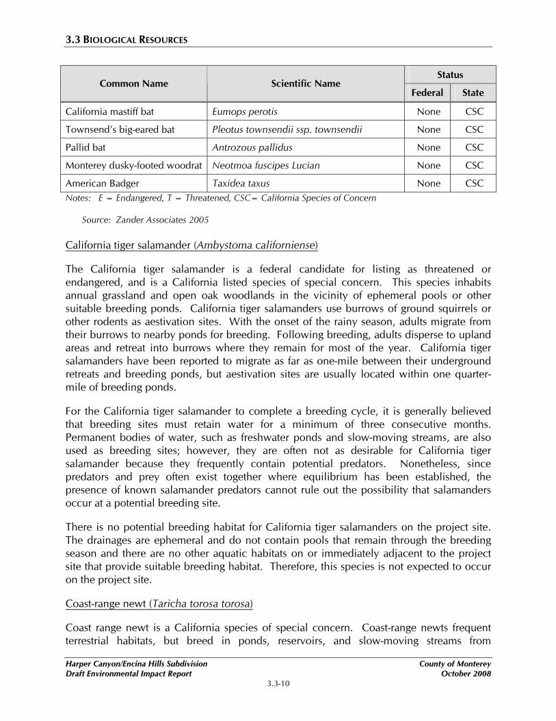
California mastiff bat Eumops perotis None CSC
Townsend’s big-eared bat Pleotus townsendii ssp. townsendii None CSC
Pallid bat Antrozous pallidus None CSC
Monterey dusky-footed woodrat Neotmoa fuscipes Lucian None CSC
American Badger Taxidea taxus None CSC Notes: E = Endangered, T = Threatened, CSC= California Species of Concern
Source: Zander Associates 2005
California tiger salamander (Ambystoma californiense)
The California tiger salamander is a federal candidate for listing as threatened or endangered, and is a California listed species of special concern. This species inhabits annual grassland and open oak woodlands in the vicinity of ephemeral pools or other suitable breeding ponds. California tiger salamanders use burrows of ground squirrels or other rodents as aestivation sites. With the onset of the rainy season, adults migrate from their burrows to nearby ponds for breeding. Following breeding, adults disperse to upland areas and retreat into burrows where they remain for most of the year. California tiger salamanders have been reported to migrate as far as one-mile between their underground retreats and breeding ponds, but aestivation sites are usually located within one quarter-mile of breeding ponds.
For the California tiger salamander to complete a breeding cycle, it is generally believed that breeding sites must retain water for a minimum of three consecutive months. Permanent bodies of water, such as freshwater ponds and slow-moving streams, are also used as breeding sites; however, they are often not as desirable for California tiger salamander because they frequently contain potential predators. Nonetheless, since predators and prey often exist together where equilibrium has been established, the presence of known salamander predators cannot rule out the possibility that salamanders occur at a potential breeding site.
There is no potential breeding habitat for California tiger salamanders on the project site. The drainages are ephemeral and do not contain pools that remain through the breeding season and there are no other aquatic habitats on or immediately adjacent to the project site that provide suitable breeding habitat. Therefore, this species is not expected to occur on the project site.
Coast-range newt (Taricha torosa torosa)
Coast range newt is a California species of special concern. Coast-range newts frequent terrestrial habitats, but breed in ponds, reservoirs, and slow-moving streams from
Harper Canyon/Encina Hills Subdivision County of Monterey Draft Environmental Impact Report October 2008
3.3-10
3.3 BIOLOGICAL RESOURCES
Mendocino County to San Diego County. Lack of data on the movement ecology of this species prevents a complete characterization of the microhabitats used. The Coast-range newt is a conspicuous diurnal salamander that, if the behavior of the related red-bellied newt (T. rivularis) can be considered an appropriate indicator, probably engages in sometimes long-distance (greater than one kilometer) migrations to breeding sites. Adult newts eat a wide variety of aquatic and terrestrial invertebrates, as well as egg masses, larvae, and carrion.
The closest CNDDB occurrence of this species is from Hastings Natural Reserve located in Carmel Valley. The drainages on the project site are ephemeral and do not provide suitable breeding habitat for the coast-range newt because of the lack of permanent water. Nonetheless, there is limited potential for these drainages to serve as dispersal corridors if there are unknown populations breeding in permanent water bodies within one kilometer of the project site.
Monterey dusky-footed woodrat (Neotoma fuscipes Luciana)
Monterey dusky-footed woodrat is a federally listed species of concern and a California listed species of special concern. While these designations do not afford the species any legal protection, they do meet the definition of rare and endangered pursuant to Section 15380 of the CEQA Guidelines. The Monterey dusky-footed woodrat is restricted to western and central Monterey County and northwestern San Luis Obispo County. This subspecies is typically found within dense chaparral or oak woodland habitats with moderately dense understory growth and abundant dead wood for nest construction. This species is likely to occur in the coast live oak woodlands on the project site.
Coast horned lizard (Phrynosoma coronatum)
Coast horned lizard is a federally listed species of concern and a California listed species of special concern. This species is distributed in the California coastal ranges extending from Sonoma County south to Mexico. Coast horned lizards inhabit open country, especially sandy areas, washes, flood plains and wind-blown deposits in a wide variety of habitats, including shrublands, woodlands, riparian habitats, and annual grassland. Warm, sunny, open areas are a main habitat requirement, along with patches of loose soils where the lizard can bury itself. During the site reconnaissance performed by Zander Associates, Coast horned lizards were seen in the 180-acre “Remainder parcel,” and potentially suitable habitat for this animal exists elsewhere on the project site, especially in the chamise chaparral-dominated habitat.
Two-striped garter snake (Thamnophis hammondii)
Two-striped garter snake is a California listed species of special concern. The two-striped garter snake is a highly aquatic snake rarely found far from water, which it freely enters to forage or escape predators. It commonly inhabits perennial and intermittent streams having rocky beds bordered by willow thickets or other dense vegetation. This species also
County of Monterey Harper Canyon/Encina Hills Subdivision October 2008 Draft Environmental Impact Report
3.3-11
3.3 BIOLOGICAL RESOURCES
inhabits large sandy riverbeds with riparian vegetation along the stream course, or stock ponds and other artificially created aquatic habitats if a dense riparian border of emergent vegetation and amphibian and fish prey are present. Adult snakes display use of different areas and habitats in summer versus winter. During the summer, snakes utilize streamside sites and have home ranges that vary from approximately 80 square meters to over 5,000 square meters. During winter, they occupy coastal sage scrub and grassland locations in uplands adjacent to riparian areas, and have home ranges that vary from approximately 50 square meters to nearly 9,000 square meters.
The closest CNDDB occurrence of this species is from Pine Canyon approximately 5.5 miles south of Salinas and approximately 3.5 miles east of the project site. The drainages on the project site are ephemeral and do not provide permanent water bodies or dense riparian vegetation for two-striped garter snakes to forage or escape predators. However, the project site could be within the home range of two-striped garter snake and the drainages could be used as corridors to get to over wintering sites.
Sensitive bat species
Several species of bats considered sensitive in California could occur in the vicinity of the project site. Such species include the pallid bat (Antrozous pallidus), California mastiff bat (Eumpos perotis) and Townsend’s big-eared bat (Plecotus townsendii ssp. townsendii). All of these bat species are federally listed species of concern by the USFWS and/or are California listed species of special concern by the CDFG. Each could potentially use the project site, especially the coast live oak woodlands, as roosting habitat. Day roosts can be found in tree cavities, old buildings, caves or rocky outcrops. Bats generally leave these day roosts at dusk to forage for invertebrates in a variety of habitats, including annual grasslands and various shrublands and woodlands.
Migratory birds
Potential nesting sites for birds-of-prey and other migratory birds exist in the coast live oak woodlands, as well as in the large individual oak trees that are scattered throughout the project site. Potential nesting habitat for special status birds species such as, the Cooper’s Hawk (Accipiter cooperi), Sharp-shinned hawk (Accipiter striatus), and Golden eagle (Aquila chrysaetos) occurs within the oak woodland habitat found throughout the project site.
WILDLIFE CORRIDORS
Wildlife corridors refer to established migration routes commonly used by resident and migratory species for passage from one geographic location to another. Corridors are present in a variety of habitats and link otherwise fragmented acres of undisturbed area. Maintaining the continuity of established wildlife corridors is important to: a) sustain species with specific foraging requirements; b) preserve a species’ distribution potential;
Harper Canyon/Encina Hills Subdivision County of Monterey Draft Environmental Impact Report October 2008
3.3-12
3.3 BIOLOGICAL RESOURCES
and c) retain diversity among many wildlife populations. Therefore, resource agencies consider wildlife corridors to be a sensitive resource.
3.3.2 REGULATORY SETTING
FEDERAL ENDANGERED SPECIES ACT
The Federal Endangered Species Act (FESA) was enacted in 1973 to protect species that are endangered or threatened with extinction. FESA prohibits the “take” of a listed (endangered or threatened) species and defines “take” as harassing, harming, pursuing, hunting, shooting, wounding, killing, trapping, capturing, or collecting wildlife species or any attempt to engage in such conduct (16 USC 1531 et seq.; 50 CFR 17.1 et seq.).
Section 7 of FESA directs all federal agencies to conserve endangered and threatened species and, in consultation with the USFWS, to ensure that their actions (or actions under their jurisdiction) do not jeopardize listed species or adversely modify critical habitat. Section 10 of FESA directs private landowners, corporations, state and local governments, or other non-Federal landowners to develop a Habitat Conservation Plan (HCP) and obtain an incidental take permit from USFWS before conducting any activity on their land that potentially may harm (or “take”) a listed species. Some of FESA designations include:
• Federally listed endangered;
• Federally listed threatened;
• Federally proposed endangered; and
• Federally proposed threatened.
MIGRATORY BIRD TREATY ACT
The Migratory Bird Treaty Act (16 USC 703) prohibits the taking, hunting, killing, selling, purchasing, etc., of migratory birds, parts of migratory birds, and their eggs and nests. Most native bird species on the project site are covered by this act. In practice, abiding by the Migratory Bird Treaty Act usually means to avoid removal of trees with active nests until such time as the young have fledged and the nest is abandoned.
CALIFORNIA FISH AND GAME CODE
The California Fish and Game Code (Section 3511) also provides for protection of certain species. Section 3503.5 of the Fish and Game Code specifically protects the nests and eggs of birds-of-prey and essentially overlaps with the Migratory Bird Treaty Act.
CLEAN WATER ACT
The Clean Water Act, as amended in 1977, established the basic structure for regulating discharges of pollutants into waters of the United States. Section 404 of the Clean Water
County of Monterey Harper Canyon/Encina Hills Subdivision October 2008 Draft Environmental Impact Report
3.3-13
3.3 BIOLOGICAL RESOURCES
Act requires Corps authorization for the discharge of dredged or fill material into all waters of the United States, including adjacent and isolated wetlands. Discharge of fill material includes, but is not limited to: placement of fill that is necessary for the construction of any other structure, or impoundment requiring rock, sand, dirt, or other material for its construction; site-development fills for recreational, industrial, commercial, residential, and other uses; causeways or road fills; dams and dikes; artificial islands; property protection or reclamation devices such as riprap, groins, seawalls, breakwaters, and revetments; beach nourishment; levees; fill for intake and outfall pipes and sub-aqueous utility lines; fill associated with creation of ponds; dewatering of dredged material prior to final disposal; fills for access roadways, cofferdams, storage and work areas; and any other work involving the discharge of fill or dredged material (33 CFR 26). A Corps permit is required for both permanent and temporary discharges. Section 401 of the Clean Water Act requires any activity that may result in a discharge of a pollutant into waters of the United States comply with applicable regulatory water quality standards. The State Regional Water Quality Control Board administers Section 401 permits for these activities.
CALIFORNIA ENDANGERED SPECIES ACT
The California Endangered Species Act (CESA) was enacted in 1984 to ensure that actions under state agency jurisdiction do not jeopardize the existence of state-listed endangered or threatened species. Similar to the FESA, the CESA prohibits taking of state-listed endangered or threatened plants and wildlife. CESA requires state agencies to consult with the DFG when preparing California Environmental Quality Act (CEQA) documents for projects or actions potentially impacting listed species or special habitats. DFG determines whether jeopardy of a state-listed species may occur and offers reasonable project alternatives or guidance for mitigation planning. DFG designations for listed plants are as follows:
• State listed endangered;
• State listed threatened;
• State listed rare; and
• State candidate for listing.
CALIFORNIA CODE OF REGULATIONS
In addition to formally listed species, many other species in California have regulatory protection under various sections of the California Code of Regulations enforced by the DFG. Species that may be considered for listing, due to declining numbers or threatened habitat, are protected as “rare” or “species of special concern.” Certain species are also designated as “fully protected,” which prevents take of an individual or their habitat unless for scientific purposes. In addition, the California Code of Regulations protects avian species by making it unlawful to take or possess migratory non-game birds, raptors, or the nest or eggs of any bird species.
Harper Canyon/Encina Hills Subdivision County of Monterey Draft Environmental Impact Report October 2008
3.3-14

3.3 BIOLOGICAL RESOURCES
Natural areas to be protected are also designated in the California Code of Regulations, including significant wildlife habitat, refuges, natural sloughs, riparian areas, and vernal pools. Waterways in particular are protected, such that, any project that may divert or obstruct the natural flow or substantially alter the bed, channel, or bank of any waterway is subject to regulatory review by the DFG.
CALIFORNIA NATIVE PLANT SOCIETY
The California Native Plant Society (CNPS) maintains and publishes an Inventory of Rare and Endangered Vascular Plants of California. The inventory presents information regarding native California plant species that show a declining population, limited distribution, or are considered by the scientific community to be threatened with extinction. Projects under CEQA review are required to address potential impact to CNPS-listed plants. CNPS definitions for listed plants are as follows:
• List 1A: Plants believed extinct;
• List 1B: Plants rare, endangered, or threatened in California and elsewhere;
• List 2: Plants rare, endangered, or threatened in California, but more numerous elsewhere;
• List 3: Plants about which we need more information; and
• List 4: Plants of limited distribution.
SENATE BILL 1334 – OAK WOODLANDS CONSERVATION ACT
As of January 1, 2005 County governments statewide must comply with Senate Bill 1334 (SB 1334). Section 21083.4 of the CEQA Guidelines addresses the requirements of SB 1334. Under the provisions of the bill, projects with significant oak woodland impacts must conform to both the state’s mandated program that established habitat mitigation standards, as well as local conservation measures adopted by Monterey County. The proposed project is subject to SB 1334 because it contains native species of oaks greater than 5-inches diameter at breast height (dbh); it is not subject to stocking regulations for timber harvest; and consists of more than 100 units.
County of Monterey Harper Canyon/Encina Hills Subdivision October 2008 Draft Environmental Impact Report
3.3-15
3.3 BIOLOGICAL RESOURCES
COUNTY OF MONTEREY
Monterey County General Plan
Policies
7.1.1 Development shall be carefully planned in, or adjacent to, areas containing limited or threatened plant communities, and shall provide for the conservation and maintenance of the plant communities.
7.1.2 The County shall encourage the protection of limited or threatened plant communities through dedications of permanent conservation easements and other appropriate means.
7.2.2 Native and native compatible species, especially drought resistant species, shall be utilized to the extent possible in fulfilling landscaping requirements imposed as conditions of discretionary permits.
9.1.1 Development shall be carefully planned in areas known to have particular value for wildlife and, where allowed, shall be located so that the reasonable value of the habitat for wildlife is maintained.
Toro Area Plan
There are no known rare or endangered wildlife species in the planning area. The following policy is used to enforce protection of environmentally sensitive habitats:
Policy
7.2.3 The preservation of oak trees in Toro shall be promoted by discouraging removal of healthy trees with diameters in excess of eight inches.
Monterey County Zoning Ordinance
Ordinance
21.64.260 No oak or Madrone tree six inches or more in diameter two feet above ground level shall be removed in the North County Area Plan or Toro Area Plan areas without approval of the permit(s) required in Subsection 21.64.260D. In addition under §21.64.260.C.5 no landmark oak tree shall be removed in any area except as may be approved by the Director of Planning Department pursuant to Subsection 21.64.260D. Landmark oak trees are those trees which are 24 inches or more in diameter when measured two feet above the ground, or trees which are visually significant, historically significant, or exemplary of their species.
Harper Canyon/Encina Hills Subdivision County of Monterey Draft Environmental Impact Report October 2008
3.3-16
3.3 BIOLOGICAL RESOURCES
Removal of more than three protected trees on a lot in a one-year period shall require a Forest Management Plan and approval of a Use Permit by the Monterey County Planning Commission per Section 21.64.260.D.3 of the Zoning Ordinance.
3.3.3 IMPACTS AND MITIGATION MEASURES
STANDARDS OF SIGNIFICANCE
The following thresholds for measuring a project’s environmental impacts are based on CEQA Guidelines and standards used by the County of Monterey. For the purposes of this EIR, impacts are considered significant if the following could result from implementation of the proposed project:
1) Result in a substantial adverse effect, either directly or through habitat modifications, on any species identified as a candidate, sensitive, endangered, threatened, or other special-status in local or regional plans, policies and regulations, or by the DFG or USFWS;
2) Result in a substantial adverse effect on any riparian habitat or other sensitive natural community identified in local or regional plans, policies and regulations, or by the DFG or USFWS;
3) Result in a substantial adverse effect on federally protected wetlands as defined by Section 404 of the Clean Water Act (including, but not limited to, coastal, riverine, stream, marsh, vernal pool, etc.) through direct removal, filling, hydrological interruption, or other means;
4) Interfere substantially with the movement of any native resident or migratory fish or wildlife species or with established native resident or migratory wildlife corridors, or impede the use of native wildlife nursery sites;
5) Conflict with any local polices or ordinances protecting biological resources, such as a tree preservation policy; or
6) Conflict with the provisions of an adopted Habitat Conservation Plan, Natural Community Conservation Plan, or other approved local, regional, or state habitat conservation plan.
An evaluation of the significance of potential impact on biological resources must consider both direct effects to the resource as well as indirect effects in a local or regional context. Potentially significant impacts would generally result in the loss of a biological resource or obviously conflict with local, state, or federal agency conservation plans, goals, policies, or regulations. Actions that would potentially result in a significant impact locally may not be considered significant under CEQA if the action would not substantially affect the resource on a population-wide or region-wide basis.
County of Monterey Harper Canyon/Encina Hills Subdivision October 2008 Draft Environmental Impact Report
3.3-17
3.3 BIOLOGICAL RESOURCES
METHODOLOGY
Surveys were conducted by Zander Associates for special status wildlife species as well as, spring and summer blooming special status plant species in March, April, and August of 2001. In September 2005, Zander Associates conducted focused surveys for special status plant species that bloom during the late summer/fall and verified special status plant species locations previously identified during the surveys conducted in the spring and summer of 2001. A Forest Management Plan was prepared by Staub Forestry and Environmental Consulting, in June 2001. An Addendum to the Forest Management Plan was prepared in April 2008. The biological assessment and forest management plan are included in Appendix C.
PROJECT IMPACTS AND MITIGATION MEASURES
Potential Disturbance of Special Status Plant Species
Impact 3.3-1 Implementation of the proposed project may result in temporary disturbance and direct alteration/impact of special status plant species. This would be considered a potentially significant impact.
Three special status plant species were identified on the project site: Monterey manzanita (Arctostaphylos montereysensis), Monterey ceanothus (Ceanothus cuneatus var. rigidus), and Gairdner’s yampah (Perideridia gairdneria).
Monterey manzanita species were identified within Lots #2, #13 and the 180-acre “Remainder parcel.” Monterey Manzanita is listed as “Rare, Threatened or Endangered in California” with the California Native Plant Society, which fall under state regulatory authority and may fall under federal regulatory authority.
Monterey ceanothus was identified within the southeastern portion of the 180-acre remainder parcel. Monterey ceanothus is listed as “Plants of Limited Distribution (on a watch list)” with the California Native Plant Society, which generally do not fall under specific state or federal regulatory authority.
Gairdner’s yampah was identified in the northernmost canyon within oak woodland habitat between Lots #3 and #4. Gairdner’s yampah is listed as “Plants of Limited Distribution (on a watch list)” with the California Native Plant Society, which generally do not fall under specific state or federal regulatory authority.
Special status plant species were not found within the approximate location of the proposed homesites, as shown in Figure 3.3-1, Biological Resource Map. Special status plant species surveys were conducted in the spring and summer of 2001 and in the fall of 2005. Seven listed special status plant species included in the fall of 2005 plant survey were not included in the spring or summer surveys in 2001. Although these seven listed special status plant species were not identified onsite during the fall of 2005, surveys conducted during the spring or summer would better determine their absence or presence
Harper Canyon/Encina Hills Subdivision County of Monterey Draft Environmental Impact Report October 2008
3.3-18
3.3 BIOLOGICAL RESOURCES
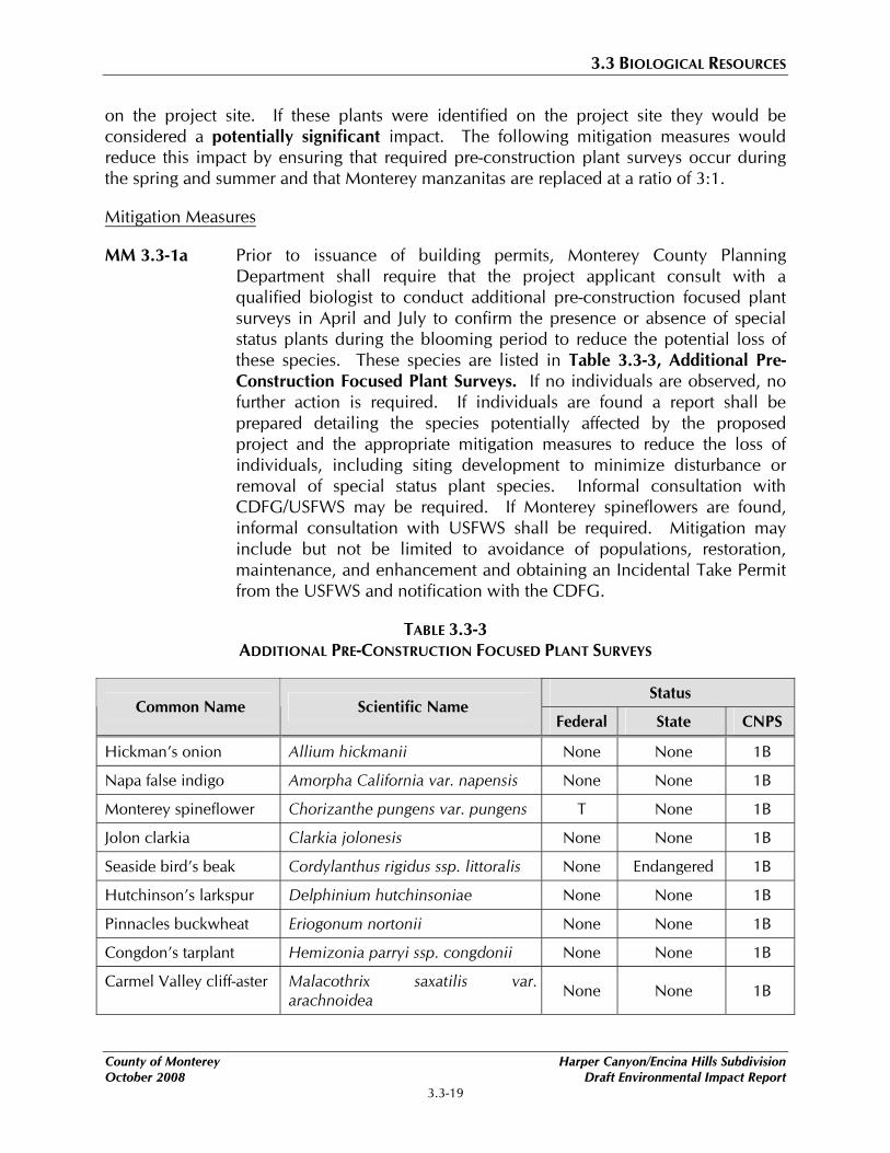
on the project site. If these plants were identified on the project site they would be considered a potentially significant impact. The following mitigation measures would reduce this impact by ensuring that required pre-construction plant surveys occur during the spring and summer and that Monterey manzanitas are replaced at a ratio of 3:1.
Mitigation Measures
MM 3.3-1a Prior to issuance of building permits, Monterey County Planning Department shall require that the project applicant consult with a qualified biologist to conduct additional pre-construction focused plant surveys in April and July to confirm the presence or absence of special status plants during the blooming period to reduce the potential loss of these species. These species are listed in Table 3.3-3, Additional Pre-Construction Focused Plant Surveys. If no individuals are observed, no further action is required. If individuals are found a report shall be prepared detailing the species potentially affected by the proposed project and the appropriate mitigation measures to reduce the loss of individuals, including siting development to minimize disturbance or removal of special status plant species. Informal consultation with CDFG/USFWS may be required. If Monterey spineflowers are found, informal consultation with USFWS shall be required. Mitigation may include but not be limited to avoidance of populations, restoration, maintenance, and enhancement and obtaining an Incidental Take Permit from the USFWS and notification with the CDFG.
TABLE 3.3-3 ADDITIONAL PRE-CONSTRUCTION FOCUSED PLANT SURVEYS
Status Common Name Scientific Name
Federal State CNPS
Hickman’s onion Allium hickmanii None None 1B
Napa false indigo Amorpha California var. napensis None None 1B
Monterey spineflower Chorizanthe pungens var. pungens T None 1B
Jolon clarkia Clarkia jolonesis None None 1B
Seaside bird’s beak Cordylanthus rigidus ssp. littoralis None Endangered 1B
Hutchinson’s larkspur Delphinium hutchinsoniae None None 1B
Pinnacles buckwheat Eriogonum nortonii None None 1B
Congdon’s tarplant Hemizonia parryi ssp. congdonii None None 1B
Carmel Valley cliff-aster Malacothrix saxatilis var. arachnoidea None None 1B
County of Monterey Harper Canyon/Encina Hills Subdivision October 2008 Draft Environmental Impact Report
3.3-19
3.3 BIOLOGICAL RESOURCES
Status Common Name Scientific Name
Federal State CNPS
Santa Lucia bush mallow Malacothamnus palmeri var. palmeri None None 1B
Yadon’s rein orchid Piperia yadonii E None 1B
Hooked popcorn flower Plagiobothrys uncinatus None None 1B
Maple-leaved checkerbloom
Sidalcea malchroides None None 1B
Santa Cruz micorseris Stebbinsoseris decipiens None None 1B
Santa Cruz clover Trifolium buckwestorium None None 1B
Pacific Grove clover Trifolium polyodon None R 1B Notes: E = Endangered, T = Threatened, R = Rare
1B = Rare, Threatened or Endangered in California & elsewhere according to CNPS 4 = Plants of Limited Distribution, a watch list according to CNPS
Source: Zander Associates 2005
MM 3.3-1b Monterey Manzanita (Arctostaphylos montereyensis) shall be avoided or replaced during construction. If the approximate locations of the home sites change within Lots #2 and #13, the project applicant shall hire a qualified biologist to cultivate stock of Monterey Manzanita plants from existing plants located within these lots. The individual Monterey Manzanita plants removed from within Lots #2 and #13 shall be replaced at a 3:1 ratio within undeveloped areas of Lots #2 and #13 using stock collected by qualified biologist.
Implementation of the above mitigation measures will reduce potential impacts to special status plant species to a less than significant level by requiring focused surveys to determine the presence of such species and if identified onsite, provides for collections and relocation of protected species.
Potential Disturbance of Sensitive Habitat
Impact 3.3-2 Implementation of the proposed project would result in the construction of buildings, roads and other facilities that may in turn result in the loss of habitat for several sensitive species through the introduction of non-native species. This would be considered a potentially significant impact.
Biological surveys conducted by Zander Associates identified potential habitat for several sensitive plant and wildlife species on the project site. The introduction of non-native invasive species as landscape material could threaten to alter the composition of these
Harper Canyon/Encina Hills Subdivision County of Monterey Draft Environmental Impact Report October 2008
3.3-20
3.3 BIOLOGICAL RESOURCES
native habitats. Increase in human activity in the area may displace some of the indigenous wildlife species that are less tolerant of disturbance.
The grassland, oak woodland/savanna, and chamise chaparral habitats identified on the project site are typical for the area surrounding the project site. Grassland habitats support a common array of native and introduced grasses and forbs found in grazing land throughout Monterey County. The denser oak woodlands and chamise chaparral communities, especially where they line drainage courses, are the most biologically diverse areas on the project site. Sensitive plant species such as the Toro (or Monterey) manzanita (Arctostaphylos montereyensis) and Monterey ceanothus (Ceanothus cuneatus var. rigidus) are associated with the chamise chaparral habitat and sensitive plant species Gairdner’s yampah (Perideridia gairdneri ssp. gairdneri) was observed on the project site within the oak woodland. All three habitats found on the project site support several sensitive wildlife species including the California horned lizard (Phrynosoma coronatum frontale), two-striped garter snake (Thamnophis hammondii), burrowing owl (Athene cunicularia), California mastiff bat (Eurmops perotis), Townsend’s big-eared bat (Pleotus townsendii ssp.townsendii), Pallid bat (Antrozous pallidus), and Monterey dusky-footed woodrat (Neotmoa fuscipes Lucian). In addition, stream channels throughout the project site provide habitat corridors, as well as, a natural system for carrying seasonal flows during the winter months. While there is no classic riparian vegetation associated with these drainage areas, the canopy cover is typically denser, proving a mesic (moist) environment for wildlife.
Although many of the displaced indigenous wildlife species may be able to move into the adjacent open space areas, the loss or disturbance of habitats that support sensitive plant and wildlife species would be considered a potentially significant impact. The following mitigation measures would reduce disturbance of sensitive habitats and introduction of invasive non-native plant species.
Mitigation Measures
MM 3.3-2a Prior to issuance of building permit, Monterey County Planning Department shall require that the project applicant submit landscape design plans, reviewed by a qualified botanist, for review and approval. The plant list shall exclude any invasive and non-native plants and emphasize the use of native species requiring minimal irrigation, herbicides, pesticides, or fertilizers and are drought-tolerant native species from local sources. Drought-tolerant non-native species may be used if they are known to be non-invasive.
MM 3.3-2b Prior to final grading sign off, Monterey County Planning Department shall require that the project applicant control the introduction of non-native, invasive plants through rapid re-vegetation of denuded areas with plants and seed harvested from areas proposed for development or other appropriate seed mixes. The seed mix selected shall contain native
County of Monterey Harper Canyon/Encina Hills Subdivision October 2008 Draft Environmental Impact Report
3.3-21
3.3 BIOLOGICAL RESOURCES
species. If non-native species are within the mix, the species will be known not to be invasive or persistent. The seed mix shall contain species known to compete well against non-native, invasive species. In areas of re-vegetation, non-landscaped disruption and adjacent to landscaping, the project applicant shall have a botanist or resource ecologist annually monitor for non-native species and invasive plant species, especially French broom, for a period of three years and provide an annual written status report to Monterey County Planning Department.
MM 3.3-2c Monterey County Planning Department shall require that the project applicant consult with a qualified botanist to develop CC&Rs that describes the native flora and fauna and provides guidelines for homeowners to follow to limit disturbance of native habitat. Said CC&Rs shall be recorded with the final map, for each parcel created by the final map.
MM 3.3-2d Prior to issuance of building permits, Monterey County Planning Department shall require that the project applicant design the proposed project so that homesites, landscaped areas and outbuildings are located a minimum of 75 feet to 100 feet from the active drainage channels to avoid filling or disturbing natural drainage courses. In the event that disturbances cannot be avoided (culverts, storm drain outfalls, etc.), the necessary permits from the California Department of Fish and Game (CDFG) through section 1600 of the Fish and Game Code and/or the U.S. Army Corps of Engineers through Section 404 of the Clean Water Act may be required. Necessary permits and/or authorizations should be obtained from appropriate regulatory agencies prior to any activity that might encroach on drainage channels.
Implementation of the above mitigation measures will reduce the introduction of non-native invasive plants species and provide guidelines to future residents to reduce the disturbance of native species. Therefore the impact to sensitive habitats would be reduced to a less than significant level.
Loss of Sensitive Coast Live Oak Woodland Habitat and Oak Trees
Impact 3.3-3 Implementation of the proposed project would result in permanent alteration of site conditions that may result in the loss of oak woodland habitat and in the removal of approximately 79 coast live oak trees from the project site. This would be considered a significant impact.
Coast live oak woodland is considered a sensitive habitat and is located on Lots #1 to #3; #7 to #8; #10 to #12; and #15 to #17, and the 180-acre “Remainder parcel.” A Forest Management Plan prepared by Staub Forestry and Environmental Consulting in June 2001 estimates the native oak tree population at the project site and potential removal associated
Harper Canyon/Encina Hills Subdivision County of Monterey Draft Environmental Impact Report October 2008
3.3-22
3.3 BIOLOGICAL RESOURCES
with implementation of the proposed project. According to the Forest Management Plan, tree cover at the project site is almost exclusively coast live oak (Quercas agrifolia) with a few buckeyes (Aesculus californica). The health of the trees on the project site is considered fair to good and includes a total 9,187 oak trees with 993 trees greater than 12 inches in diameter.
The proposed project includes a use permit for the removal of approximately 79 oak trees, which is less than one percent of the total trees located on the project site. Of the trees to be removed, approximately 14 percent of the trees are estimated to be greater than 12 inches in diameter. Approximately 20 to 26 percent of the trees to be removed are suffering from extensive decay, breakage, and/or low vigor. Tree removal would occur primarily within the limits of the grading area to install a 20-foot wide roadway that generally follows the existing dirt road on the project site. According to the Addendum to the Forest Management Plan dated June 2001 (April 28, 2008), tree impacts associated with development of proposed building sites are projected to be minimal since the building site locations are proposed in open areas containing grassland or mixed grass and shrub cover with only occasional oaks. No tree removal would occur on nine of the seventeen lots and little tree removal would occur on the remaining eight lots. Tree removal at the project site is subject to the requirements of Section 21.64.260 of the Monterey County Zoning Ordinance (Title 21) and Section 21083.4 of the CEQA Guidelines.
According to the ordinance, no protected tree shall be removed without a use permit unless the trees are diseased or hazardous, as designated by a qualified forester, or exempt from the provisions of the ordinance. As 20 to 26 percent of the trees proposed for removal are in poor health and tree removal would consist of less than one percent of the project site, the effects to the oak woodland habitat would be consistent with Section 21.64.260 of the Monterey County Zoning Ordinance. However, the tree count conducted in June 2001 was based on trees greater than six inches in diameter at breast height (dbh) instead of five inches in diameter dbh as required by Section 21083.4 of the CEQA Guidelines.
In addition to tree removal, oak woodland habitat and specific trees may experience adverse impacts during the construction activities at the project site. Construction activities associated with development of the proposed project may result in root system damage. Cutting or other damage to roots during excavation and soil compaction due to vehicle operation can both cause damage to the root system, thus reducing the tree’s vigor and potentially leading to the death of the tree. Since the root system of the tree extends approximately to the dripline, excavation or soil-compaction within the dripline of the trees could result in the adverse effects, which is considered a significant impact. Implementation of the following mitigation measures would ensure that tree removal is in accordance with Section 21.64.260 of the Monterey County Zoning Ordinance and Section 21083.4 of the CEQA Guidelines and that those trees proposed for preservation are not affected by construction activities associated with the proposed project.
County of Monterey Harper Canyon/Encina Hills Subdivision October 2008 Draft Environmental Impact Report
3.3-23
3.3 BIOLOGICAL RESOURCES
Mitigation Measures
MM 3.3-3a During the roadway and building site final design process, Monterey County Planning Department shall require that the project applicant contract with a qualified arborist to prepare a Final Forest Management Plan that minimizes the removal of coast live oak (Quercas agrifolia) trees in accordance with the recommendations in Section 21083.4 of the CEQA Guidelines and the Forest Management Plan that was prepared for the proposed project by Staub Forestry and Environmental Consulting in June 2001. A qualified arborist or professional forester shall identify where trees can be retained and establish conservation easements, trees that need pruning, areas that require keyed fills, etc. All recommended pruning shall be performed by a qualified arborist or other tree professional and occur prior to commencement of grading. The Final Forest Management Plan shall be subject to review and approval by the Monterey County Planning Department prior to issuance of grading permits.
MM 3.3-3b Prior to the issuance of grading permits, the project applicant shall submit a Final Forest Management Plan for review and approval by Monterey County Planning Department as required in mitigation measure MM 3.3-3a. The Final Forest Management Plan shall include a monitoring plan that accurately identifies the number and acreage of oak trees five inches in diameter at breast height to be removed during construction and the replacement of these oak trees on a 3:1 basis as a means of promoting 1:1 tree replacement in compliance with Section 21.64.260 of the Monterey County Zoning Ordinance and Section 21083.4 of the CEQA Guidelines. Tree replacement on residential lots shall occur as space permits and shall not exceed more than one tree per 10 foot by 10 foot block of available space. If a specific lot does not allow for replanting of trees, the project applicant shall have a qualified forester identify an alternate location for replanting on the project site. Tree replacement for infrastructure tree removals shall be placed within any scenic easements and/or the portion of the “Remainder Parcel” that would be dedicated to the Monterey County Parks District as an extension of the adjacent Toro Park. All trees shall be replaced with coast live oak (Quercas agrifolia) trees obtained from onsite sources or should be grown from local native seed stock in sizes not greater than five gallons, with one gallon or smaller being preferred to increase chances of successful adaptation to the project conditions. Replacement trees shall be monitored and maintained for a minimum of seven years after planting. The monitoring plan shall be prepared by a qualified professional forester, arborist, horticulturalist, and shall be subject to review and approval by the County of Monterey Planning Department.
Harper Canyon/Encina Hills Subdivision County of Monterey Draft Environmental Impact Report October 2008
3.3-24
3.3 BIOLOGICAL RESOURCES
MM 3.3-3c As a condition of project approval, the County of Monterey Planning Department shall require that the project applicant, in consultation with a qualified professional forester, develop Covenants, Conditions, and Restrictions (CC&Rs) that shall include oak tree protection measures as outlined in the Forest Management Plan (Staub Forestry and Environmental Consulting 2001) on individual lots as part of future home construction to minimize the damage to oak trees and ensure successful replanting. These measures shall include, but not be limited to the following:
• Around each group of trees to be preserved within a construction area, a boundary of snow netting of high visibility plastic fencing supported by wood or metal stakes shall be placed along the approximate dripline of such protected trees to define the construction project boundary;
• No storage of equipment or construction materials, or parking of vehicles shall be permitted within the tree rooting zone defined by the fencing of the construction boundary defined above;
• No soil may be removed from within the dripline of any tree and no fill that exceeds two inches shall be placed at the base of any tree, unless it is part of approved construction and is reviewed by a qualified forester, certified arborist, or other tree professional;
• Roots exposed by excavation during construction shall be pruned promptly to promote callusing, closure, and regrowth; and
• All tree work shall be monitored by a qualified forester, certified arborist, or tree professional and work completed by qualified tree service personnel.
Said CC&Rs shall be recorded with the final map, for each parcel created by the final map.
Implementation of the above mitigation measures would minimize loss of oak woodland habitat and removal of coast live oak trees in accordance with Section 21.64.260 of the Monterey County Zoning Ordinance and Section 21083.4 of the CEQA Guidelines. Therefore, the impact to sensitive oak woodland habitat would be reduced to a less than significant level.
Potential Disturbance of Special Status Bats
Impact 3.3-4 Implementation of the proposed project may result in the construction of buildings, roads and other facilities that may in turn result in the disturbance of the pallid bat (Antrozous pallidus), California mastiff bat (Eumpos perotis) or Townsend’s big-eared bat (Plecotus townsendii ssp. townsendii), California listed species of special concern by California
County of Monterey Harper Canyon/Encina Hills Subdivision October 2008 Draft Environmental Impact Report
3.3-25
3.3 BIOLOGICAL RESOURCES
Department of Fish and Game. This would be considered a potentially significant impact.
The project site contains habitat that supports three special status bat species: Pallid bat (Antrozous pallidus), California mastiff bat (Eumpos perotis) and Townsend’s big-eared bat (Plecotus townsendii ssp. townsendii), which are California listed species of special concern by the California Department of Fish and Game. These species may potentially use the oak woodland habitat on the project site for roosting. Removal of approximately 79 oak trees would directly impact these special-status bats if present at the time of removal and removal of the oak woodland habitat would indirectly impact special-status bats by reducing the amount of available habitat. This would be considered a potentially significant impact. The following mitigation measure has been provided to reduce the impact on special status bat species to a less than significant level. Mitigation Measure
MM 3.3-4 Prior to the initiation of grading and site disturbance, Monterey County Planning Department shall require that the project applicant contract with a qualified biologist to perform a pre-construction survey for special-status bat species within the project site to comply with the California Fish and Game (CDFG) Code relative to special status bat maternity roosts. Prior to tree removal in the coast live oak woodland, a qualified biologist shall survey the trees to evaluate their potential use by special-status bat species. If special-status bat species are determined to be using these trees, or trees in the immediate vicinity, the biologist shall provide recommendations to avoid harming individual bats or disturbance of active roosts. If the biologist recommends active removal of bats, a Memorandum of Understanding (MOU) with the CDFG shall be obtained. Alternate habitat may need to be provided if bats are to be excluded from maternity roosts. A roost with comparable spatial and thermal characteristics should be constructed as directed by a qualified biologist. In the event that adult bats need to be handled and relocated, a qualified biologist shall prepare and implement a relocation plan subject to approval by CDFG that includes relocating all bats found on-site to an alternate suitable habitat. A Mitigation and Monitoring Plan that documents mitigation for loss of bat roosting habitat should be prepared by a qualified biologist and approved by CDFG prior to tree removal.
Implementation of the above mitigation measure would reduce impacts to special-status bats species to a less than significant level by requiring pre-construction surveys for special-status bat species within the project site and if any bats are subsequently found during the surveys provide recommendations to avoid harming individual bats or disturbance of active roosts.
Harper Canyon/Encina Hills Subdivision County of Monterey Draft Environmental Impact Report October 2008
3.3-26
3.3 BIOLOGICAL RESOURCES
Potential Disturbance of Monterey Dusky-Footed Woodrat
Impact 3.3-5 Implementation of the proposed project would result in short-term disturbance and long-term alteration of site conditions that may have direct and indirect affects on the Monterey dusky-footed woodrat (Neotoma fuscipes luciana), a California listed species of special concern by California Department of Fish and Game. This would be considered a potentially significant impact.
The Monterey dusky-footed woodrat is a California listed species of special concern. Noise, dust, and vibration associated with construction activities provide short-term direct impacts on the Monterey dusky-footed woodrats’ mortality and habitat. Loss of available oak woodland habitat would have long-term indirect impacts on the Monterey dusky-footed woodrat by reducing the amount of available habitat. The proposed project would not significantly affect the population of Monterey dusky-footed woodrat at the project site as they are regionally rare but locally abundant. However the following mitigation measure would ensure that they are not adversely affected during construction activities at the project site.
Mitigation Measure
MM 3.3-5 No more than 30 days prior to grading or construction in oak woodland habitat, Monterey County Planning Department shall require that the project applicant contract with a qualified biologist to complete a pre-construction survey for the Monterey dusky-footed woodrat. If individuals of these species are observed, a salvage and relocation program shall be prepared in coordination with CDFG to prevent death or injury to individuals of these species during grading or construction operations. The salvage program shall include measures to remove individuals from the project site prior to and during project grading and construction, and to relocate them to a suitable location within the project site.
Implementation of the above mitigation measure would reduce impacts to Monterey Dusky-Footed Woodrat to a less than significant level.
Potential Loss of Migratory Bird Habitat and Species
Impact 3.3-6 Implementation of the proposed project would result in temporary and direct disturbance to nesting raptors and migratory birds. This would be considered a potentially significant impact.
Habitat within the project site provides suitable foraging opportunities for many avian species, including some raptors and migratory birds. In addition, suitable nesting habitat for the golden eagle and white-tailed kite is located on the project site. Raptors and raptor nests are considered to be a special resource by federal and state agencies and are
County of Monterey Harper Canyon/Encina Hills Subdivision October 2008 Draft Environmental Impact Report
3.3-27
3.3 BIOLOGICAL RESOURCES
protected under the MBTA and California Code of Regulations. All migratory birds are also protected under the MBTA. Future development within the project site may affect suitable habitat for these avian species.
Construction activities that require disturbance of trees or other vegetation containing active nests could cause direct impact to nesting raptor and migratory birds. Disturbance of active nests within the project site would be considered a potentially significant impact if take of a sensitive bird species occurred through nest abandonment. Construction could also result in noise, dust, increased human activity, and other indirect impacts to nesting raptors or migratory bird species in the project vicinity. Potential nest abandonment, mortality to eggs and chicks, as well as stress from loss of foraging areas would also be considered a potentially significant impact. Implementation of the following mitigation measure would reduce this impact.
Mitigation Measure
MM 3.3-6 Surveys shall be conducted no more than 30 days prior to ground disturbance during the nesting seasons for local avian species (typically February 1st through August 31st). The Monterey County Planning Department shall require that the project applicant retain a qualified biologist to conduct a focused survey for active nests of raptors and migratory birds within and in the vicinity of the construction area. If active nests are located during preconstruction surveys, USFWS and/or CDFG (as appropriate) shall be notified regarding the status of the nests and agency recommendations regarding nest avoidance measures implemented. Furthermore, construction activities shall be restricted as necessary to avoid disturbance of the nest until it is abandoned or the biologist deems disturbance potential to be minimal. Restrictions may include establishment of exclusion zones (no ingress of personnel or equipment at a minimum radius of 100-feet around the nest) or alteration of the construction schedule. No action is necessary if construction will occur during the non-breeding season (between August 1st and November 1st).
Implementation of the above mitigation measure would reduce impacts to raptors and migratory birds to a less than significant level by limiting the exposure of nesting raptor and migratory birds to construction activities.
Conflicts with Adopted Habitat Conservation Plan.
The proposed project is not located within an area associated with an adopted Habitat Conservation Plan. Therefore there will be no impact associated with a Habitat Conservation Plan.
Harper Canyon/Encina Hills Subdivision County of Monterey Draft Environmental Impact Report October 2008
3.3-28
3.3 BIOLOGICAL RESOURCES
CUMULATIVE IMPACTS AND MITIGATION MEASURES
Cumulative Effect on Special Status Species and Sensitive Habitats
Impact 3.3-7 Buildout of the proposed project, combined with buildout of reasonably foreseeable development within the vicinity of the project site, would result in disturbance to special status species and sensitive habitats throughout the region. However, implementation of mitigation measures presented within this section, MM 3.3-1 through MM 3.3-6, would reduce the overall contribution to cumulative biological resource impacts resulting from buildout of the proposed project. Therefore, this would be considered a less than significant cumulative impact.
As presented in the impact discussions above (see Impacts 3.3-1 through 3.3-6), implementation of the proposed project would result in a disturbance to special status species and sensitive habitats. When these impacts are combined with biological resources impacts associated with reasonably foreseeable development within the vicinity of the project site, the disturbance to special status species and sensitive habitats is likely to be compounded and considered a cumulative impact. However, implementation of mitigation measures presented within this section, MM 3.3-1 through MM 3.3-6, would reduce the overall contribution to cumulative biological resource impacts resulting from buildout of the proposed project. Therefore, the proposed project’s contributions to the cumulative loss and/or restriction of biological resources in the region are considered less than significant.
County of Monterey Harper Canyon/Encina Hills Subdivision October 2008 Draft Environmental Impact Report
3.3-29
3.3 BIOLOGICAL RESOURCES
References/Documentation
Monterey, County of. Monterey County General Plan. August 1982 with Amendments through November 5, 1996.
Monterey, County of. Toro Area Plan. September 1983 with Amendments through 1998.
Staub Forestry and Environmental Consulting. Forest Management Plan. June 2001.
Staub Forestry and Environmental Consulting. Addendum to Forest Management Plan dated June 2001 for Monterey County APNs 416-611-01 and 416-611-03 – Encina Hills. April 28, 2008.
Zander Associates. Biological Resources Assessment. July 13, 2001.
Zander Associates. Results of Follow-Up Survey. October 3, 2001.
Zander Associates. Biological Resources Assessment. November 11, 2005.
Harper Canyon/Encina Hills Subdivision County of Monterey Draft Environmental Impact Report October 2008
3.3-30