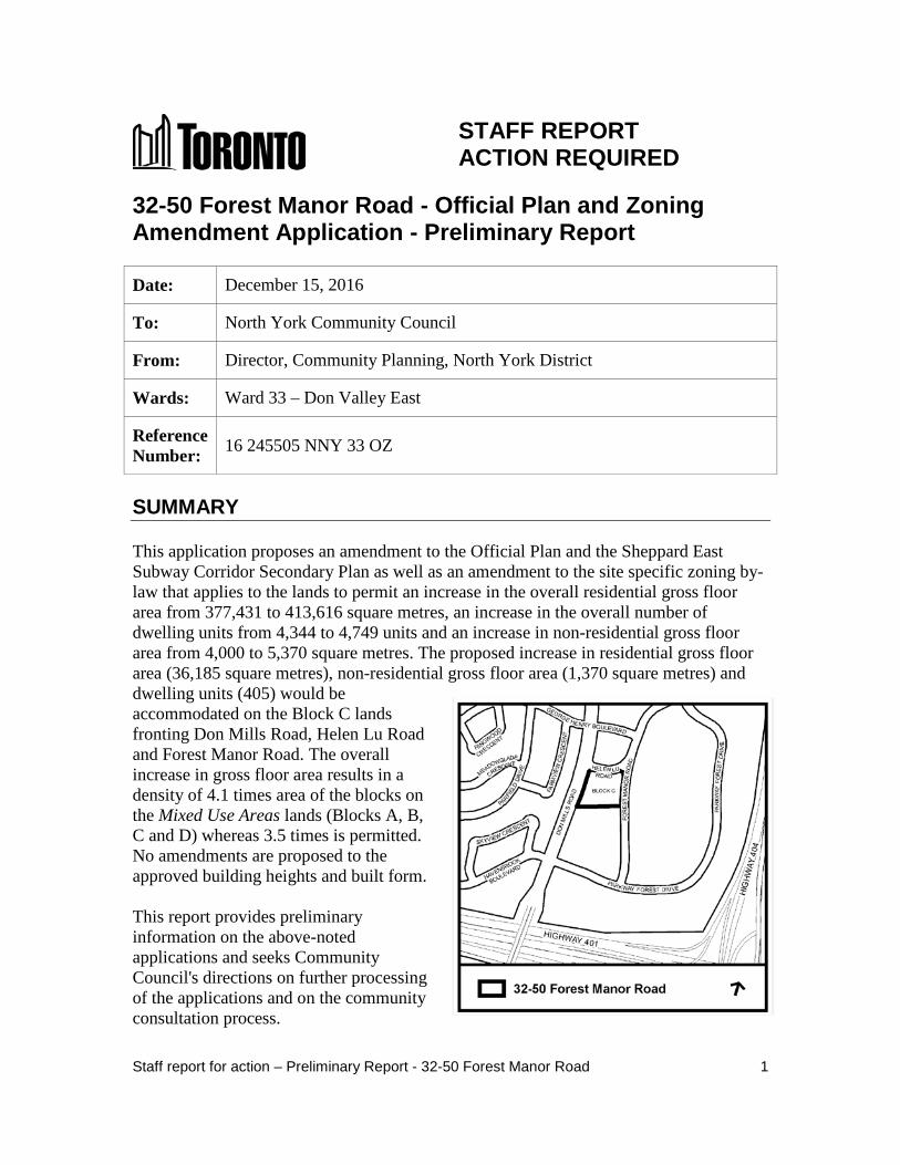
32-50 Forest Manor Road - Official Plan and Zoning ... · STAFF REPORT . ACTION REQUIRED . 32-50...
21
STAFF REPORT ACTION REQUIRED 32-50 Forest Manor Road - Official Plan and Zoning Amendment Application - Preliminary Report Date: December 15, 2016 To: North York Community Council From: Director, Community Planning, North York District Wards: Ward 33 – Don Valley East Reference Number: 16 245505 NNY 33 OZ SUMMARY This application proposes an amendment to the Official Plan and the Sheppard East Subway Corridor Secondary Plan as well as an amendment to the site specific zoning by- law that applies to the lands to permit an increase in the overall residential gross floor area from 377,431 to 413,616 square metres, an increase in the overall number of dwelling units from 4,344 to 4,749 units and an increase in non-residential gross floor area from 4,000 to 5,370 square metres. The proposed increase in residential gross floor area (36,185 square metres), non-residential gross floor area (1,370 square metres) and dwelling units (405) would be accommodated on the Block C lands fronting Don Mills Road, Helen Lu Road and Forest Manor Road. The overall increase in gross floor area results in a density of 4.1 times area of the blocks on the Mixed Use Areas lands (Blocks A, B, C and D) whereas 3.5 times is permitted. No amendments are proposed to the approved building heights and built form. This report provides preliminary information on the above-noted applications and seeks Community Council's directions on further processing of the applications and on the community consultation process. Staff report for action – Preliminary Report - 32-50 Forest Manor Road 1
-
Upload
nguyendien -
Category
Documents
-
view
215 -
download
0
Transcript of 32-50 Forest Manor Road - Official Plan and Zoning ... · STAFF REPORT . ACTION REQUIRED . 32-50...
STAFF REPORT ACTION REQUIRED
32-50 Forest Manor Road - Official Plan and Zoning Amendment Application - Preliminary Report
Date: December 15, 2016
To: North York Community Council
From: Director, Community Planning, North York District
Wards: Ward 33 – Don Valley East
Reference Number: 16 245505 NNY 33 OZ
SUMMARY This application proposes an amendment to the Official Plan and the Sheppard East Subway Corridor Secondary Plan as well as an amendment to the site specific zoning by-law that applies to the lands to permit an increase in the overall residential gross floor area from 377,431 to 413,616 square metres, an increase in the overall number of dwelling units from 4,344 to 4,749 units and an increase in non-residential gross floor area from 4,000 to 5,370 square metres. The proposed increase in residential gross floor area (36,185 square metres), non-residential gross floor area (1,370 square metres) and dwelling units (405) would be accommodated on the Block C lands fronting Don Mills Road, Helen Lu Road and Forest Manor Road. The overall increase in gross floor area results in a density of 4.1 times area of the blocks on the Mixed Use Areas lands (Blocks A, B, C and D) whereas 3.5 times is permitted. No amendments are proposed to the approved building heights and built form. This report provides preliminary information on the above-noted applications and seeks Community Council's directions on further processing of the applications and on the community consultation process.
Staff report for action – Preliminary Report - 32-50 Forest Manor Road 1
The report recommends that a community consultation meeting be scheduled by City Planning staff, in consultation with the Ward Councillor. A Final Report and a Public Meeting under the Planning Act is targeted for the third quarter of 2017 providing the applicant submits all required information in a timely manner. RECOMMENDATIONS The City Planning Division recommends that: 1. Staff be directed to schedule a community consultation meeting for the lands at
32-50 Forest Manor Road together with the Ward Councillor. 2. Notice for the community consultation meeting be given to landowners and
residents within 120 metres of the site. 3. Notice for the public meeting under the Planning Act be given according to the
regulations of the Planning Act. Financial Impact The recommendations in this report have no financial impact. DECISION HISTORY On September 15, 2008, Official Plan Amendment No. 579 to the former City of North York Official Plan and Zoning By-law No. 865-2008(OMB) were approved by the Ontario Municipal Board (OMB). The planning instruments implement City Council's settlement on the revitalization of lands in the Parkway Forest community located in the area south of Sheppard Avenue East and east of Don Mills Road. The amendments permitted a mixed-use residential/commercial development consisting of nineteen buildings and a total of 3,753 dwelling units. The approved units comprised 332 rental replacement units, maintaining 1,221 rental apartment units as they existed and the construction of 2,200 new condominium dwelling units in a series of buildings ranging from 7 to 36 storeys in height. The development has been proceeding in phases over the last seven years (see Attachment 1: Phasing Plan). The zoning by-law appends five holding symbols (“H”) to the lands that set out conditions to be met prior to the removal of a specific holding provision. The conditions deal with matters pertaining to transportation, traffic management and the construction of the new community centre/child care facility. To date, the first three holding symbols ("H-1", "H-2" and "H-3") have been removed from the implementing zoning by-law. On October 2, 2014, the OMB approved a zoning amendment to permit an increase in the number of dwelling units from 3,753 to 4,344 units (an increase of 591 new condominium units) over the five development blocks. Zoning By-law No. 342-2015(OMB) replaced Zoning By-law No. 865-2008(OMB) and sets out performance
Staff report for action – Preliminary Report - 32-50 Forest Manor Road 2

standards to accommodate the 591 additional condominium units with amended building heights and with built forms that more appropriately reflected the City's Tall Building Design Guidelines. There were no amendments to the zoning by-law with respect to maximum gross floor area and density. On August 23, 2016, the owner of the lands Elad Canada Inc (Elad), filed a zoning by-law amendment application requesting removal of the two remaining holding symbols ("H-4" and ""H-5"") from the site specific Zoning By-law No. 342-2015(OMB) to enable the remaining 617 dwelling units and 3,480 square metres of retail space on Blocks B and C to be completed and/or proceed in accordance with the current zoning by-law permissions.
Pre-Application Consultation A pre-application consultation meeting was held with the applicant to discuss complete application submission requirements. ISSUE BACKGROUND
Proposal This application proposes an increase in the overall residential gross floor area from 377,431 to 413,616 square metres, an increase in the overall number of (combined) dwelling units from 4,344 to 4,749 units and an increase in non-residential (retail) gross floor area on Blocks B and C from 4,000 to 5,370 square metres. The proposed gross floor area increase results in a density of 4.1 times the area of the lot (Floor Space Index) whereas 3.5 times the area of the lot is permitted. The application proposes to effectively change only the gross floor area and number of dwelling units for Block C. No amendments are proposed to the approved building heights and built form. The proposal would result in a total of 920 units on Block C, a total residential gross floor area of 71,600 square metres (an increase of 36,185 square metres) and a total non-residential (retail) gross floor area of 5,370 square metres (an increase of 1,370 square metres). The revised plan proposes to change only the gross floor area and number of dwelling units for Block C after recognition is given to a provision in the zoning by-law intended to provide flexibility for the multi-phase development. The by-law allows an increase (or redeployment) in the number of dwelling units and/or gross floor area from one development Block to another provided the overall number of dwelling units and gross floor area on all of the Blocks (A through D) combined do not exceed a maximum of 4,344 units and 377,431 square metres respectively. The proposed increases therefore, beyond the maximum overall by-law permissions, are proposed to be accommodated within the approved built forms. The proposed unit breakdown is as follows: • Building C1 (approved building height up to 13 storeys) would contain a total of
256 units; Staff report for action – Preliminary Report - 32-50 Forest Manor Road 3
• Building C2 (approved building height up to 24 storeys) would contain a
total of 290 units; and
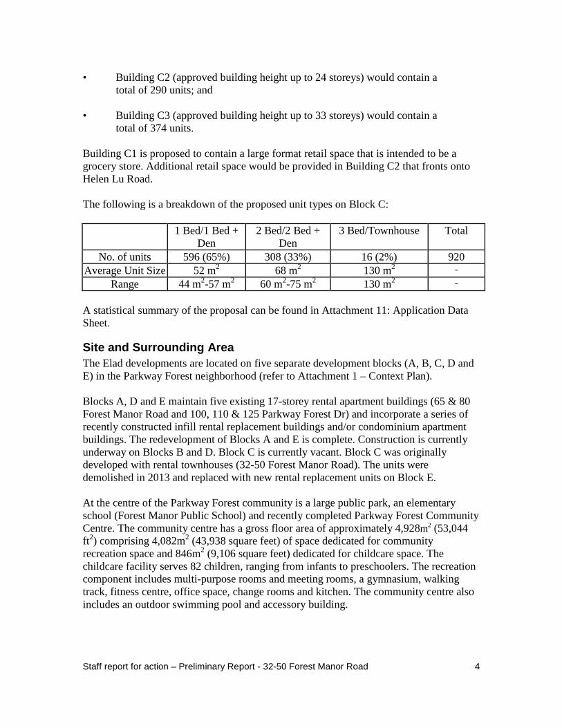
• Building C3 (approved building height up to 33 storeys) would contain a total of 374 units.
Building C1 is proposed to contain a large format retail space that is intended to be a grocery store. Additional retail space would be provided in Building C2 that fronts onto Helen Lu Road. The following is a breakdown of the proposed unit types on Block C:
1 Bed/1 Bed + Den
2 Bed/2 Bed + Den
3 Bed/Townhouse Total
No. of units 596 (65%) 308 (33%) 16 (2%) 920 Average Unit Size 52 m2 68 m2 130 m2 -
Range 44 m2-57 m2 60 m2-75 m2 130 m2 -
A statistical summary of the proposal can be found in Attachment 11: Application Data Sheet.
Site and Surrounding Area The Elad developments are located on five separate development blocks (A, B, C, D and E) in the Parkway Forest neighborhood (refer to Attachment 1 – Context Plan). Blocks A, D and E maintain five existing 17-storey rental apartment buildings (65 & 80 Forest Manor Road and 100, 110 & 125 Parkway Forest Dr) and incorporate a series of recently constructed infill rental replacement buildings and/or condominium apartment buildings. The redevelopment of Blocks A and E is complete. Construction is currently underway on Blocks B and D. Block C is currently vacant. Block C was originally developed with rental townhouses (32-50 Forest Manor Road). The units were demolished in 2013 and replaced with new rental replacement units on Block E. At the centre of the Parkway Forest community is a large public park, an elementary school (Forest Manor Public School) and recently completed Parkway Forest Community Centre. The community centre has a gross floor area of approximately 4,928m2 (53,044 ft2) comprising 4,082m2 (43,938 square feet) of space dedicated for community recreation space and 846m2 (9,106 square feet) dedicated for childcare space. The childcare facility serves 82 children, ranging from infants to preschoolers. The recreation component includes multi-purpose rooms and meeting rooms, a gymnasium, walking track, fitness centre, office space, change rooms and kitchen. The community centre also includes an outdoor swimming pool and accessory building.
Staff report for action – Preliminary Report - 32-50 Forest Manor Road 4
The community centre, outdoor pool and accessory building and surface parking were designed and constructed at no ‘capital cost’ to the City and funded through Section 37 benefits. The revitalization of the Parkway Forest community also included a new public road (Helen Lu Road) that was completed in 2014. The new road (Helen Lu Rd) connects Forest Manor Road to a new signalized intersection at Don Mills Road and is located between Blocks B and C. The development also features a series of colourful public art installations located throughout the community that were designed by Canadian artist Douglas Copeland. The following is a summary of the context in the immediate vicinity of Block C: North: Helen Lu Road, then Block B currently being redeveloped by Elad Canada
Inc. with 841 dwelling units in three residential apartment buildings with heights from 7-13 storeys along Don Mills Road, 5-24 storeys along Helen Lu Road and 4-33 storeys along Forest Manor Road/George Henry Boulevard;
South: a 10-storey, 128-unit rental apartment building municipally known as 24
Forest Manor Road and a tennis court associated with the apartment building at 10 Parkway Forest Drive, adjacent to Don Mills Road;
East: Forest Manor Road, then Parkway Forest Community Centre and Parkway
Forest Public School; and West: Don Mills Road, then the rear yards of single family dwellings fronting
onto Skyview Crescent and Farmview Crescent.
Provincial Policy Statement and Provincial Plans The Provincial Policy Statement (PPS) 2014 provides policy direction on matters of provincial interest related to land use planning and development. These policies support the goal of enhancing the quality of life for all Ontarians. Key policy objectives include: building strong healthy communities; wise use and management of resources; and protecting public health and safety. The PPS recognizes that local context and character is important. Policies are outcome-oriented, and some policies provide flexibility in their implementation provided that provincial interests are upheld. City Council’s planning decisions are required, by the Planning Act, to be consistent with the PPS. The Growth Plan for the Greater Golden Horseshoe provides a framework for managing growth in the Greater Golden Horseshoe including: directions for where and how to grow; the provision of infrastructure to support growth; and protecting natural systems and cultivating a culture of conservation. City Council’s planning decisions are required to conform, or not conflict, as the case may be, with the Growth Plan for the Greater Golden Horseshoe. Staff report for action – Preliminary Report - 32-50 Forest Manor Road 5
Staff will review the proposed development for consistency with the PPS and for conformity with the Growth Plan for the Greater Golden Horseshoe.
Official Plan The lands are designated Mixed Use Areas on Land Use Map 16 of the Toronto Official Plan (see Attachment 10- Official Plan). This designation provides for a broad range of commercial, residential and institutional uses in single-use or mixed-use buildings as well as parks and open spaces. The Official Plan contains policies that provide direction and criteria on site design matters pertaining to the location and organization of buildings, vehicle parking, access locations and service areas. The Official Plan's built form policies indicate that new development should be designed to fit with its existing and/or planned context; frame and support adjacent streets, parks and open spaces; and limit its impacts on neighbouring streets, parks and properties. Policies relevant to this application include Policies 3.1.1 (Public Realm), 3.2.1 (Built Form), 4.5(2) (Development Criteria in Mixed Use Areas) and 5.1.1 (Section 37 – Height and/or Density Incentives). The Secondary Plan for the area provides further direction on these matters. The Toronto Official Plan is available on the City's website at: http://www.toronto.ca/planning/official_plan/pdf_chapter1-5/chapters1_5_aug2007.pdf
Sheppard East Subway Corridor Secondary Plan The site is also subject to the Sheppard East Subway Corridor Secondary Plan set out in Chapter 6, Section 9 of the Toronto Official Plan. The Secondary Plan contains policies that are area-specific and at a greater level of detail than those in the Official Plan. The site is part of a Key Development Area in the Don Mills Node of the Secondary Plan. The Plan assigns a maximum density of 3.5 FSI on the Mixed Use Areas lands along Don Mills Road and Sheppard Avenue East (Blocks A, B, C and D) and 1.9 FSI on the central lands designated Apartment Neighbourhoods (Block E) bounded by Parkway Forest Park, Parkway Forest Drive and Forest Manor Road, as indicated on Map 9-2 of the Plan. In addition to the general policies of the Secondary Plan, the site is subject to the area specific development policies of Section 4.2.8 – Parkway Forest Community. Within this specific policy area the highest building heights and densities are to be located in close proximity to the Don Mills Subway Station and to a lesser extent along the Don Mills Road and Sheppard Avenue East frontages. Lower densities are to be located towards the interior of the community around the public park. As noted previously, while no changes are proposed to the approved building heights and built form, the application proposes an increase in gross floor area which results in an increase in density from 3.5 times the lot area to 4.1 times the lot area. The Sheppard East Subway Corridor Secondary Plan is available on the City’s website at: http://www.toronto.ca/planning/official_plan/pdf_secondary/9_sheppard_subway_aug2007.pdf Staff report for action – Preliminary Report - 32-50 Forest Manor Road 6
Zoning The lands are currently zoned RM6(168)A (H-4)(H-5) by site specific Zoning By-law No. 342-2015(OMB)(refer to Attachments 8 and 9). The zoning establishes performance standards for residential development on five development blocks (A, B, C, D and E) in the Parkway Forest neighbourhood. Permitted uses include apartment house dwellings, community agency space, townhouses, commercial uses and community agency space along Sheppard Avenue East, and a public community centre/day care facility. The zoning by-law permits a maximum gross floor area of 377,431m2 and 4,344 dwelling units on the five development blocks. The dwelling units comprise 2,791 new condominium units, 1,221 existing rental apartment units in 17-storey apartment buildings and 332 rental replacement units in mid-rise apartment buildings and townhouses. The by-law sets out a maximum number of dwelling units and gross floor area per block and allows increases up to 10% in the number of dwelling units and gross floor area per building provided the total number of dwelling units and gross floor area on all of the Blocks combined does not exceed the overall maximum permissions. The implementing zoning by-law appends five holding symbols (“H”) to the lands that set out conditions to be met prior to the removal of a specific holding provision. The conditions deal with matters pertaining to transportation, traffic management and the construction of the (now completed) community centre/child care facility. To date, three holding symbols have been removed from the implementing zoning by-law ("H-1", "H-2" and "H-3") leaving only to two remaining holding symbols ("H-4" and "H-5"). The criteria for the removal of the remaining two holding symbols are outlined below: ▪ As a pre-condition to the removal of the "H-4" holding symbol all of the
following conditions must be met:
a. the owner must have completed the outdoor swimming pool and accessory building and parkland enhancements on the City owned lands on Parkway Forest Park to the satisfaction of the General Manager, Parks, Forestry & Recreation;
b. the owner must satisfy the parkland dedication requirements to the
satisfaction of the General Manager, Parks, Forestry & Recreation; and c. the owner of the site must have submitted a Traffic Impact Analysis
satisfactory to the Director, Transportation Services, North York District, addressing the timing of the westbound Sheppard Avenue East to southbound Don Mills Road double left turning lane construction, as well as any other improvements which might be identified at this stage.
Staff report for action – Preliminary Report - 32-50 Forest Manor Road 7
▪ As a pre-condition of the removal of the “H-5” holding symbol, both of the
following conditions must be met:
a. the owner must have either constructed or posted financial security for, if deemed required by the Director, Transportation Services, North York District, the westbound Sheppard Avenue East to southbound Don Mills double left turning lane; and
b. the owner must have submitted a Transportation Impact Study to
the satisfaction of the Director, Transportation Services, North York District, to demonstrate that there is sufficient transportation capacity available to accommodate additional site generated traffic or measures that can be undertaken to accommodate additional traffic.
On August 23, 2016, Elad Canada submitted a zoning by-law amendment application to remove the last two holding symbols ("H-4" and "H-5") from the site specific zoning by-law. The application is currently under review.
Site Plan Control On November 27, 2016, Elad filed a Site Plan Control application for the first phase of development on Block C (Phase 5B - Building C3) comprising a 33-storey, 371-unit condominium apartment building and 600 square metres of retail space. The application is currently under review. The "H-4" holding symbol would need to be removed from the implementing zoning by-law to enable this phase to proceed in accordance with the underlying zoning.
Tree Preservation An Arborist Report and tree inventory plan for Block C has been submitted with the application and will be reviewed to determine the condition of existing trees and any necessary tree protection and maintenance plan. The owner will be required to obtain the necessary permits prior to removing any trees pursuant to Private Tree Protection By-law No. 780-2004 and the ‘Trees On City Streets’ By-law.
Reasons for the Application The proposal requires an amendment to the Official Plan through amendments to Site and Area Specific Policy 4.2.8 - Parkway Forest Community and Map 9-2 of the Sheppard East Subway Corridor Secondary Plan to increase the density on the Mixed Use Areas lands (Blocks A, B, C and D) from 3.5 times the area of the blocks to 4.1 times the area of the blocks. Amendments to Zoning By-law No. 342-2015(OMB) are required to:
Staff report for action – Preliminary Report - 32-50 Forest Manor Road 8

▪ increase the overall number of combined dwelling units on the lands from 4,344
(comprising 332 rental replacement + 1221 existing rental apartment units + 2,791 condominium units) to 4,749 combined dwelling units;
▪ increase the overall residential gross floor on the lands from 377,431 square
metres to 413,616 square metres; and ▪ increase the non-residential (retail) gross floor area permitted on Blocks B and C
by 1,370 square metres from 4,000 square metres to 5,370 square metres. The additional 405 condominium units, 36,185 square metres of residential gross floor area and 1,370 square metres of non-residential (retail) gross floor area are proposed to be accommodated on Block C. COMMENTS
Application Submission The following reports/studies were submitted with the application: ▪ Surveys, Architectural Plans, Engineering Drawings, Landscape Plans ▪ Planning & Urban Design Rationale ▪ Transportation Impact Study • Stormwater Management Report, Functional Servicing Letter, Geotechnical
Engineering Report, Hydrogeological Investigation • Arborist/Tree Preservation Report, Tree Removal and Protection Plan • Toronto Green Standards Checklist and Statistics Template. A Notification of Complete Application was issued on November 23, 2016.
Issues to be Resolved On a preliminary basis, matters to be addressed through the review of this application include: ▪ appropriateness of the proposed increase in density from 3.5 to 4.1 FSI; ▪ appropriateness of the proposed additional 405 dwelling units; ▪ unit size and mix, particularly the provision of family size units; ▪ consideration for the provision of affordable housing to be included in the proposal; Staff report for action – Preliminary Report - 32-50 Forest Manor Road 9

▪ evaluation of capacity to accommodate the traffic generated by the 405 additional
dwelling units and 1,370 square metres of non-residential (retail) gross floor area; ▪ the appropriateness of the proposed parking and potential parking impacts on
local streets; ▪ assessment of the stormwater management and servicing; ▪ determination of appropriate Section 37 community benefits should City Council
approve the additional 37,655 square metres of gross floor area. The TGS Checklist has been submitted by the applicant and is currently under review by City staff for compliance with the Tier 1 performance measures. Additional issues may be identified through the review of the application, agency comments and the community consultation process. CONTACT Steve Forrester, Senior Planner Tel. No. (416) 395-7126 Fax No. (416) 395-7155 E-mail: [email protected] SIGNATURE _______________________________ Joe Nanos, Director Community Planning, North York District ATTACHMENTS Attachment 1: Context Plan Attachment 2: Phasing Plan Attachment 3: Site Plan Block C Attachment 4: West (Don Mills Road) Elevation Attachment 5: East (Forest Manor Road) Elevation Attachment 6: South Elevation Attachment 7: Cross Section (East-West) Attachment 8: Zoning Former City of North York Attachment 9: Zoning City of Toronto Attachment 10: Official Plan Attachment 11: Application Data Sheet Staff report for action – Preliminary Report - 32-50 Forest Manor Road 10

Attachment 1: Context Plan
Staff report for action – Preliminary Report - 32-50 Forest Manor Road 11

Attachment 2: Phasing Plan
Staff report for action – Preliminary Report - 32-50 Forest Manor Road 12
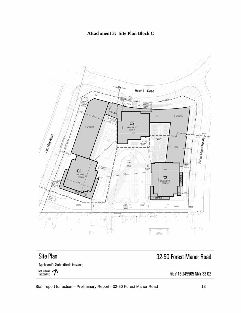
Attachment 3: Site Plan Block C
Staff report for action – Preliminary Report - 32-50 Forest Manor Road 13

Attachment 4: West (Don Mills Road) Elevation
Staff report for action – Preliminary Report - 32-50 Forest Manor Road 14

Attachment 5: East (Forest Manor Rd) Elevation
Staff report for action – Preliminary Report - 32-50 Forest Manor Road 15

Attachment 6: South Elevation
Staff report for action – Preliminary Report - 32-50 Forest Manor Road 16

Attachment 7: Section
(East-West)
Staff report for action – Preliminary Report - 32-50 Forest Manor Road 17

Attachment 8: Zoning
Former City of North York By-law No. 7625
Staff report for action – Preliminary Report - 32-50 Forest Manor Road 18

Attachment 9: Zoning
City of Toronto By-law No. 569-2013
Staff report for action – Preliminary Report - 32-50 Forest Manor Road 19
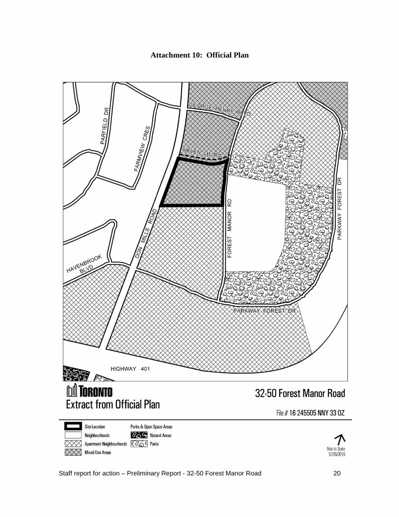
Attachment 10: Official Plan
Staff report for action – Preliminary Report - 32-50 Forest Manor Road 20

Attachment 11: Application Data Sheet
Application Type OPA & Rezoning Application Number: 16 245505 NNY 33 OZ Details OPA & Rezoning, Standard Application Date: November 1, 2016 Municipal Address: 32-50 FOREST MANOR ROAD (BLOCK C) Location Description: PLAN 7239 PT BLK I 66R23770 PART 1 **GRID N3305 Project Description: Amend the Official Plan and Sheppard East Subway Corridor Secondary Plan to permit
an increase in density on the Mixed Use Areas lands from 3.5FSI to 4.1 FSI and amend the Zoning By-law to permit an increase in overall gross floor area from 377,431 square metres to 413,616 square metres, an increase in the overall number of dwelling units from 4,344 to 4,749 units and an increase in the overall non-residential gross floor area from 4,000 square metres to 5,370 square metres. The proposed aditional gross floor area and dwelling units would be accommodated on Block C. No amendments are proposed to the approved building heights and built form.
Applicant: Agent: Architect: Owner:
BOUSFIELDS INC 3 CHURCH ST, SUITE 200 TORONTO ON M5E 1M2
TONY VOLPENTESTA (BOUSFIELDS)
WZMH ARCHITECTS 95 ST. CLAIR AVE W TORONTO ON M4V 1N6
EMERALD CITY DEV. IV INC 2235 SHEPPARD AVE E SUITE 1700 TORONTO ON M2J 5B5
PLANNING CONTROLS
Official Plan Designation: Mixed Use Areas Site Specific Provision: 4.2.8 Zoning: RM6(H-4)(H-5) Historical Status: Height Limit (m): 102 Site Plan Control Area: Y
PROJECT INFORMATION - BLOCK C
Site Area (sq. m): 14774 Height: Storeys: 33 Frontage (m): 0 Metres: 102 Depth (m): 0 Total Ground Floor Area (sq. m): 5050 Total Total Residential GFA (sq. m): 71600 Parking Spaces: 947 Total Non-Residential GFA (sq. m): 4350 Loading Docks 4 Total GFA (sq. m): 75950 Lot Coverage Ratio (%): 34.2 Floor Space Index: 4.1(Blocks A,B,C,D)
DWELLING UNITS FLOOR AREA BREAKDOWN (upon project completion)
Tenure Type: Condo Above Grade Below Grade Rooms: 0 Residential GFA (sq. m): 71600 0 Bachelor: 0 Retail GFA (sq. m): 4350 0 1 Bedroom: 596 (65%) Office GFA (sq. m): 0 0 2 Bedroom: 308 (33%) Industrial GFA (sq. m): 0 0 3 + Bedroom: 16 (2%) Institutional/Other GFA (sq. m): 0 0 Total Units: 920
CONTACT: PLANNER NAME: Steve Forrester, Senior Planner TELEPHONE/EMAIL (416) 395-7126 [email protected]
Staff report for action – Preliminary Report - 32-50 Forest Manor Road 21


![New Connaught Manor [Susquehanna Manor]](https://static.fdocuments.in/doc/165x107/629626257eb28529e46bd069/new-connaught-manor-susquehanna-manor.jpg)