
IN20080736.PL.2010-08-19.RPT.US 31...
152
August 2010 US 31 CORRIDORS COMPREHENSIVE PLAN
Transcript of IN20080736.PL.2010-08-19.RPT.US 31...
August 2010
US 31 CorridorS Comprehensive plan

US 31 CORRIDORS COMPREHENSIVE PLAN
DRAFT AUGUST 2010Steering Commitee Approval - August 12, 2010

TABLE OF CONTENTSUS 31 CORRIDORS COMPREHENSIVE PLAN
i
INTRODUCTION
Acknowledgements ........................................................................................... 2Purpose of US 31 Comprehensive Plan ........................................................ 4
VISION
Vision Introduction ............................................................................................. 8Vision Forming into Goals ................................................................................ 9
GOALS AND OBJECTIVES
Goals and Objectives ....................................................................................12Goals and Objectives Guide Sheet ............................................................13Goal 1 ...............................................................................................................16Goal 2 ...............................................................................................................23Goal 3 ...............................................................................................................31Goal 4 ...............................................................................................................44Goal 5 ...............................................................................................................49Goal 6 ...............................................................................................................56Goal 7 ...............................................................................................................70Goal 8 ...............................................................................................................74
PLANS AND STUDIES
Review of Plans and Studies .........................................................................78Site Analysis and Existing Land Use ............................................................78Market Analysis ...............................................................................................93Demographics ............................................................................................... 106Additional Objective Detail ....................................................................... 116Utilities ............................................................................................................ 126Suitability Analysis ....................................................................................... 128
PLANNING PROCESS .........................................132
APPENDIX .........................................................138


INTRODUCTION

ACKNOWLEDGEMENTS
Honorable Greg Goodnight
City of Kokomo MayorTyler MooreBill Thompson David Trine
Howard County Commissioners
City of Kokomo Common CouncilRalph Baer
Bob CameronDan Haworth
Mike KarickhoffMike Kennedy
Cynthia SandersKevin SummersMike WyantJanie Young
Corbin King - Attorney
Howard County CouncilLeslie Ellison
Richard MillerStanley OrtmanJames Papacek
Joe PencekJeffrey StoutPaul Wyman
Kokomo and Howard County Governmental Coordinating Council
Greg Goodnight, Chairman, Mayor of KokomoDave Trine, Vice Chairman, Howard County Commissioners
Mike Karickhoff, Member, Kokomo City CouncilRichard H. Miller, Howard County CouncilLes Ellison, Howard County Councilman
Greg Sheline, Member Kokomo Plan CommissionMike Kennedy, Member, Kokomo Common CouncilJames Papacek, Howard County Plan Commission
Glen R. Boise, Secretary-Treasurer, Executive Director of Kokomo & Howard County Plan Commission
City of Kokomo Plan Commission
Mike BesserPhil Burgan
Jeff KearnesLisa Rink
Santos SalinasGreg Sheline
Carey StranahanCandy Thompson
Janie YoungKen Ferries - Attorney
Glen Boise - Executive Director
Howard County Plan Commission
Max CusterCheryl Graham
Mike ImblerPaul Marcellino
Jim Miller Dan Minor
Tyler MooreHeath Van NatterJames Papacek
Brian Oaks - AttorneyAlan Wilson - Attorney (after June 2010)
Glen Boise - Executive Director
US 31 Comprehensive Plan Steering CommitteeGreg Goodnight, Mayor of KokomoCarey Stranahan, City of Kokomo
Cynthia Sanders, City of Kokomo Common CouncilJeff Kearnes, City of Kokomo Plan CommissionWilliam Thompson, Howard County CommissionMike Imbler, Howard County Plan Commission
James Papacek, Howard County CouncilJim Alender, Greater Kokomo Economic
Development Alliance BoardGlen Boise, Executive Director of
Kokomo & Howard County Plan Commission
American Structurepoint, Inc.Shane Burkhardt, AICP
Megan Coler, AICPGina Tirinnanzi, RLA, AICP
Mike Koyak, PEEric Horvath, PE
Joe Grinstead, PEKatherine Graham, PE, LEED AP
Jenna Thelan, EIJordan Lynman
Emily Perry

PUBLIC PARTICIPATION
Karen AdamsPeter Adelsen
Jim AdlerJim Alender
Ellen AndersonTom AndersonBrad BagwellLarry BarnhartSue Barnhart
Jan BassRobert James Bergman
Mike BesserP. Betsom
Tammie BockGlen BoiseMatt Boor
Stan BowneRon Broniak
Donald CaddyGary Carlile
James ChristensenRobin ColeDaniel Cole
James ColonisJeb Conrad
Assunda Rocchin CunniferSandy CunninghamTony CunninghamTom Cunningham
Max CusterSteve Dankert
Wilbur DankertMaxine Doversberger
Stephen DuncanGlenna DuncanKevin DunhamDoug Ectcheson
Les EllisonRonald FosterSusanne FoutsRandy Fruth
Grayce GadsonCheryl GrahamAndrea GrahamKathy HarbaughMonty Henderson
David HermanBarbara Herman
Mike HeroldPeggy HobsonPercy Hobson
Jane Ann HopperRex HopperBob HoshawBud HowellMike Imbler
David InskeepMike Ionblev
Larry IvesRachel JenkinsAbrah JohnsonJoan JohnsonJeff Kearnes
John KeyKevin KmisleyShery Matlock
Barbara McCombsJim McCombs
Jennifer McMullenJanie MillerTim Miller
James MillerH.R. MilnerDan Minor
Kim MorganCecil MossBev Moss
Divene MyersFern NashBill Noland
Jessica O’NeillJim Papacek
Dhiren PatelRod PeabodyDolores Phifer
Ross PierceP. Jason Rayl
Martin RinehartJames RiversBrenda RohnRex Ruillman
Santos SalinasSteve Sallee
Cindy SandersJerry Santon
Jocena SchaferRon SchaferLori Schafer
June ScogginsTim Sehr
Mariesa SkoglandRick Smith
Jennifer SopherChuck SosbeCathy Stover
Carey StranahanDeena SuttonCharlie SxongDon Thomas
Doug ThomasBill Thompson
Tom TolenDavid Trine
David TurnerRalph UnderwoodRandy UnderwoodBrenda Underwood
Elizabeth UnderwoodChuck WeigmanC. WilliamsonPaul WymanJanie Young

INTRODUCTION US 31 CORRIDORS COMPREHENSIVE PLAN
4
PURPOSE OF US 31 COMPREHENSIVE PLAN
The Comprehensive Plan is a legal document that serves as a decision-making guide for both offi cials and citizens and is intended to serve as a tool for making decisions about the promotion of public health, safety, morals, convenience, order, or the gen-eral welfare and for the sake of effi ciency and economy in the process of develop-ment. Comprehensive plans are defi ned by state statute IC 36-7-4-500 series, which outlines the intent and details of the necessary content for all plans.
The US 31 Corridors Comprehensive Plan was a joint project of the City of Kokomo and Howard County, with support from the Kokomo and Howard County Govern-mental Coordinating Council and the Kokomo - Howard County Plan Commission. The US 31 corridor in northern Indiana is primarily a four-lane divided roadway connect-ing Indianapolis to South Bend. The original US 31 route passed through downtown Kokomo until the existing bypass was constructed approximately one mile east of downtown in 1952. Development soon followed the highly traveled bypass becoming Kokomo’s primary commercial corridor. The existing bypass is a four-lane divided roadway that includes open section shoulder and open drainage, 15 signalized in-tersections, 3 at-grade railroad crossings and more than 140 minor cross-street and private property access points. The combination of commercial and industrial land uses, numerous traffi c lights, and high number of access points along the corridor cre-ated transportation diffi culties in both congestion and safety along the corridor. In 2007, the Indiana Department of Transportation decided to construct a new US 31 Bypass around Kokomo to improve north-south traffi c fl ow. The new US 31 Freeway is being constructed as a limited-access interstate roadway with fi ve interchanges ap-proximately one mile east of the existing bypass.
In order to properly plan and prevent haphazard growth from encroaching on avail-able land along the new US 31, and to improve transportation fl ow along the exist-ing US 31, the City of Kokomo and Howard County initiated the development of the US 31 Corridors Comprehensive Plan. The primary goals of this plan include:
• Identifying innovative and realistic land use and transportation solutions for Kokomo and Howard County through a community-based approach
• Identifying a set of strategies to maintain and enhance access, mobility, safety, economic development, potential redevelopment strategies, and environmental quality along the both corridors
• Providing land use recommendations to manage growth and development in the corridors
• Providing updates to the Kokomo and Howard County Comprehensive Plans• Identifying opportunities to enhance existing historic and natural assets,
including corridor view sheds• Addressing transportation issues that may arise from changes in land use in
the corridors• Identifying potential opportunity sites and creating a vision for land
use design concepts for proposed development areas and potential redevelopment areas
• Examining the potential and suitability for development along the corridors, including the need for access improvements, infrastructure extensions, economic opportunities, land-use regulations, and design guidelines

INTRODUCTION
5
US 31 CORRIDORS COMPREHENSIVE PLAN
5


VISION

VISION US 31 CORRIDORS COMPREHENSIVE PLAN
8
VISION INTRODUCTION
The vision for the US 31 corridors is a set of shared values, a rational hope, a prag-matic dream. The vision itself is a description of the intent of the plan and what is to come. It does not explain how we are going to get there, but sets forth what the com-munity hopes to achieve. The goals, objectives, and projects outlined in this plan serve as an extension of the vision, defi ning how the Kokomo and Howard County community is going to realize its vision for the new and existing US 31 corridors.
VISION
US 31 is an important transportation corridor for the State of Indiana, City of Kokomo, and Howard County that connects Indianapolis, Kokomo, and South Bend. The Kokomo and Howard County community sees both the existing and new US 31 corridors as important thoroughfares for transportation, visitors, and busi-ness to the greater Kokomo community. The new US 31 corridor maintains the primarily agricultural landscape with industrial centers located at key intersections to expand upon the large industrial base Kokomo is home to. The limited access interchanges along the new corridor provide key gateways into the Kokomo com-munity to attract visitors and promote the Kokomo community. Existing US 31 is an effi cient and safe transportation corridor for vehicles, pedestrians and public transportation. The attractive boulevard streetscape creates an inviting atmo-sphere for visitors and residents to shop along Kokomo’s primary retail corridor. Both corridors, while different in design and function, create a unique and inviting gateway to the Kokomo community for visitors, residents and businesses.
Proposed character of the existing US 31 Bypass corridor
Existing character of new US 31 Freeway corridor
Existing character of the existing US 31 Bypass corridor

VISION
9
US 31 CORRIDORS COMPREHENSIVE PLAN
VISION FORMING INTO GOALS
Comprehensive plans are about preparing for and managing change. The plan acts as a management tool designed to help the City of Kokomo and Howard County maximize the results of their efforts. Creating the comprehensive plan for the US 31 corridors relied on gathering information; assessing the community’s resources and needs; identifying the strengths, weaknesses, opportunities, and threats of the commu-nity; and adopting goals and objectives. All of this gathered information allowed the public to answer the ultimate question of “What does the community want the existing US 31 corridor and new US 31 corridor to be in 10 to 20 years?”
The comprehensive plan for the corridors began to take shape when a vision for what the area within the corridors should be in the next 10 to 20 years was created. The vision statement was created for the corridors to generally refl ect how each corridor should look and function in the future. The vision served as the foundation for a va-riety of goals and objectives that were created to help determine and provide the framework on how to get from where the corridors are today to where they should be in 20 years.
Proposed character of the new US 31 Freeway Corridor

GOALS & OBJECTIVES

GOALS &OBJECTIVES US 31 CORRIDORS COMPREHENSIVE PLAN
12
GOALS AND OBJECTIVES
Goals and objectives were created to serve as the basis for development decisions. Goals are concise statements that describe in general terms a desired future condition that further defi nes the vision. Goals represent the future state of the corridor and address those things the community wants to accomplish over the life of the plan. The goals also form the framework for more detailed decision making and will be used by the City and County to establish priorities for public and private discussion and consideration, as well as to identify needed public improvements and services.
Objectives describe a specifi c measurable future condition that is to be attained dur-ing a stated period of time and, ultimately, the course of action required to achieve a stated goal. Furthermore, the objectives are tasks that recommend how a goal will be accomplished. Objectives are statements of community intent against which individual actions and decisions are evaluated. Objectives are suffi ciently quantifi able in or-der to gauge the appropriateness of development applications, have a general time frame, and are understood by both the decision makers and the general community.
PLAN GOALS• Establish land use districts along the new US 31 corridor to ensure appropri-
ate growth and development along the corridor.• Adopt appropriate zoning regulations for areas along the existing and new
US 31 corridors to attract the desired land uses for those areas and improve and ensure aesthetically attractive corridors.
• Establish redevelopment areas along the existing US 31 corridor that include industrial and commercial property for the purposes of directing potential redevelopment investment.
• Establish identifi able nodes along the new and existing corridor to attract travelers to the Kokomo community through landmarks, landscaping enhance-ments, and/or architectural features.
• Change roadway classifi cations in the thoroughfare plan based on changes in transportation loads impacted by the new US 31 corridor to ensure adequate capacity in the transportation network.
• Improve the aesthetics and function of the existing US 31 corridor to create a more context-sensitive urban boulevard in order to function in a primarily urban area, improve commercial viability, and provide for full multi-modal accessibility and functionality for all types of traffi c.
• Increase recreational opportunities along the corridor and connections throughout the community, such as Wildcat Creek, Nickel Plate Trail, Walk of Excellence, and Kokomo Reservoir, while maintaining and protecting sensitive watersheds.
• Provide adequate sanitary and storm sewers to future land-use areas tar-geted for growth in order to attract shovel-ready development.
Goals form the Goals form the framework for more framework for more
detailed decision detailed decision making. making.

GOALS &OBJECTIVES
13
US 31 CORRIDORS COMPREHENSIVE PLAN
PROJECT OBJECTIVESHORT TERM
(0-2 years)
MEDIUM TERM
(2-5 years)
LONG TERM
(5+ years)
1. Establish land-use districts along the new US 31 corridor to ensure appropriate growth and development along the corridor.
1.1Create an industrial district north of the new US 31 interchange at CR E 450 N and CR N 50 E
X
1.2 Create an industrial district around the Touby Pike interchange at US 31 X
1.3Create an industrial district surrounding the Markland Avenue interchange along the new US 31
X
1.4 Create an industrial district surrounding the East Boulevard interchange at US 31 X
1.5Create a low-density residential district along the new US 31 corridor between CR 300 S and north of CR 200 S
X
1.6Create an industrial district surrounding the State Road 26 interchange along the new US 31
X
2. Adopt appropriate zoning regulations for areas along the existing and new US 31 corridors to attract the desired land uses for those areas and improve and ensure aesthetically attractive corridors.
2.1 Amend an overlay zone surrounding the new US 31 corridor X
2.2 Adopt an overlay zone surrounding the existing US 31 corridor X
2.3 Develop a multi-use form based zoning district to allow for more fl exibility in development X
2.4 Modify parking requirements in existing and proposed zoning districts X
2.5 Modify density requirements in existing and proposed zoning districts X
2.6 Modify building setback requirements in existing and proposed zoning districts X
2.7Add building guidelines in existing and proposed zoning districts to require four-sided architecture and building materials
X
3. Establish redevelopment areas along the existing US 31 corridor that include industrial and commercial property for the purposes of directing potential redevelopment investment.
3.1 Finalize the appropriate Redevelopment Area boundaries and complete a “Need for Redevelopment” study to determine if redevelopment within the area would not likely occur without the use of powers granted to the Redevelopment Commission
X
3.2Establish a TIF District that freezes the amount of taxes typically collected by other districts at the amount that was in effect when the TIF District was formed to fund infrastructure improvements along the existing US 31 Bypass
X
3.3Establish an Economic Improvement District along the existing US 31 Bypass which provides a reliable, multi-year source of economic development funds by using the County’s tax collection powers to assess properties belonging to the District
X
3.4Provide for future public use in the area of the existing US 31 at the proposed extension of the Nickel Plate Trail
X
3.5Redevelop the area surrounding the intersection of existing US 31 and Morgan Street as a commercial node
X
3.6Attract new general commercial uses northwest of the intersection of US 31 and Sycamore Street
X
3.7 Attract mixed-use residential uses for the area surrounding the vacant Kroger store X

GOALS &OBJECTIVES US 31 CORRIDORS COMPREHENSIVE PLAN
14
PROJECT OBJECTIVESHORT TERM
(0-2 years)
MEDIUM TERM
(2-5 years)
LONG TERM
(5+ years)
3.8Provide more opportunities for cohesive general commercial development opportunities east of existing US 31 to Belvedere Drive, between Vaile Avenue and Carter Street
X
3.9Provide more opportunities for mixed-use development or passive recreational opportunities in the area surrounding the vacant Speedway Gas Station
X
3.10Attract general commercial uses by improving access to the area southeast of the intersection of existing US 31 and Alto Road, north of Albany Drive
X
3.11Improve the condition of the site surrounding the intersection of existing US 31 and SR 26 for potential mixed use development
X
3.12Provide general commercial development opportunities for the area surrounding Markland Avenue, between the existing US 31 byass and the US 31 Freeway
X
4. Establish identifi able nodes along the new and existing corridor to attract travelers to the Kokomo community through landmarks, landscaping enhancements and/or architectural features.
4.1Relocate the Kokomo visitor centers to areas where the existing US 31 and new US 31 split from one another
X
4.2Create landmark gateways along the new US 31 to identify entrances to the Kokomo community
X
4.3Create secondary gateways along the new US 31 to identify access to the Kokomo community
X
4.4Create secondary gateways to help identify the existing US 31 corridor to travelers exiting and entering the new US 31 corridor
X
5. Change roadway classifi cations in the thoroughfare plan based on changes in transportation loads impacted by the new US 31 corridor to ensure adequate capacity in the transportation network.
5.1 Change the road classifi cation for CR 500 S, between the existing US 31 and CR 200 E, from a Local Road to a Minor Collector
X
5.2Change the road classifi cation for SR 26, east of US 31 to the new US 31 interchange, from a Minor Arterial to a Primary Arterial
X
5.3Change the road classifi cation for CR 300 S, from CR 200 E to CR 350 E, from a Minor Collector to a Major Collector
X
5.4Change the road classifi cation for CR 100 S (Boulevard), from Webster Street to CR 300 E, from a Major Collector to a Minor Arterial
X
5.5Change the road classifi cation for Touby Pike from the new northern US 31 interchange ramp to CR 300 N, from a Major Collector to a Minor Arterial
X
5.6 Add the new US 31 Bypass to the thoroughfare plan as a primary arterial X
6. Improve the aesthetics and function of the existing US 31 corridor to create a more context-sensitive urban boulevard in order to function in a primarily urban area, improve commercial viability, and provide for full multi-modal accessibility and functionality for all types of traffi c.
6.1 Implement a unifi ed streetscape design along existing US 31 X
6.2 Create crosswalks and pedestrian refuges at each intersection along the existing US 31 X
6.3Create mid-block crosswalks and pedestrian refuges where the proposed multi-use paths cross US 31
X
6.4Construct a sidewalk along one side of existing US 31 and additional sidewalk connections
X

GOALS &OBJECTIVES
15
US 31 CORRIDORS COMPREHENSIVE PLAN
PROJECT OBJECTIVESHORT TERM
(0-2 years)
MEDIUM TERM
(2-5 years)
LONG TERM
(5+ years)
6.5Construct a multi-use side path for pedestrians and bicyclists along the entire length of the US 31
X
6.6Construct sidewalks along both sides of Markland Avenue between Cooper Street and the new US 31
X
6.7 Narrow lane widths along the existing US 31 corridor X
6.8 Consider reducing the speed limit along existing US 31 X
6.9 Add a street canopy along the existing US 31 corridor X
6.10 Create a regionally recognizable commercial shopping district along existing US 31 X
6.11 Maintain the rail line connecting Kokomo to Indianapolis as a rail corridor X
6.12 Ensure that future development and road design accommodates future transit stops X
7. Increase recreational opportunities along the corridor and connections throughout the community, such as Wildcat Creek, Nickel Plate Trail, Walk of Excellence and Kokomo Reservoir, while maintaining and protecting sensitive watersheds.
7.1Expand the Kokomo trail network by constructing a multi-use trail to connect to the Walk of Excellence
X
7.2Construct trailheads along the proposed eastern extension of the Walk of Excellence along the Wildcat Creek
X
7.3 Construct trailheads along the proposed extension of the Nickel Plate Trail X
8. Provide adequate sanitary and storm sewers to future land use areas targeted for growth in order to attract shovel-ready devel-opment.
8.1 Extend sewer service to the future light industrial development area surrounding the SR 26 interchange along the new US 31
X
8.2Extend sewer service to the future industrial development area along the western edge of US 31 and east of the Kokomo corporate limits, between the Touby Pike interchange and the CERA railroad
X
8.3Extend sewer service, add a new pump station and upgrade Apperson Way Pump Station to provide for future industrial development north of the new US 31 interchange at CR RD E 450 N and CR N 50 E
X
8.4Extend sewer service and add a new pump station to provide for future industrial development surrounding the new US 31 interchange locations at Markland Avenue and East Boulevard
X
8.5Extend sewer service and build a new pump station to provide service along the New US 31 corridor between Center Road and north of CR 200 S to provide for future low-density residential development
X

GOALS &OBJECTIVES US 31 CORRIDORS COMPREHENSIVE PLAN
16
GOAL 1Establish land use districts along the new US 31 corridor to ensure appropriate growth and development along the corridor.
Future land-use map with recommended changes (See larger map in Appendix)
Legend
!( Proposed Trailhead
Proposed GatewaysLandmark Gateway
Existing Trail
Proposed Trail
Floodplain
Land Use RecommendationsIndustrial
Low Density Residential
Rural Residential
Land UseAgricultural
Rural Residential
Low Density Residential
Medium Density Residential
High Density Residential
Government/Institutional
Trails
Secondary Gateway
General Commercial
Neighborhood Commercial
Downtown Commercial
General Commercial
Parks & Recreation
Light Industrial
Medium/Heavy Industrial
Corporate BoundaryRailroadAirport Hazard Zone

GOALS &OBJECTIVES
17
US 31 CORRIDORS COMPREHENSIVE PLAN
OBJECTIVE 1.1SHORT TERM
Create an industrial district north of the new US 31 interchange at CR E 450 N and CR N 50 E to provide for a mixture of light and heavy in-dustrial uses that expand upon the existing industrial campus in the area.
The Chrysler facilities along US 31 north of Smith Road currently create a large industrial campus. The Future Land Use Maps for both the city and county identify the area east of the Chrysler facilities as future industrial land uses. The two new US 31 interchanges at Touby Pike and CR E 400 N and CR N 50 E will provide convenient access to the existing and future industrial uses. The existing industrial land uses, proposed industrial land uses from the Future Land Use Maps, interchange access, close proximity to the airport, and existing infrastructure make the northeast section of Kokomo surrounding the existing and new US 31 corridor an ideal site for future industrial development. It is recommended future industrial land uses be extended north along the existing US 31 and surrounding the new interchange at CR E 400 N and CR N 50 E in order to capitalize on the existing infrastructure and ideal proximity to the highway.
Legend
!( Proposed Trailhead
Proposed GatewaysLandmark Gateway
Existing Trail
Proposed Trail
Floodplain
Land Use RecommendationsIndustrial
Low Density Residential
Rural Residential
Land UseAgricultural
Rural Residential
Low Density Residential
Medium Density Residential
High Density Residential
Government/Institutional
Trails
Secondary Gateway
General Commercial
Neighborhood Commercial
Downtown Commercial
General Commercial
Parks & Recreation
Light Industrial
Medium/Heavy Industrial
Corporate BoundaryRailroadAirport Hazard Zone

GOALS &OBJECTIVES US 31 CORRIDORS COMPREHENSIVE PLAN
18
Accommodate future industrial growth for existing industrial areas around Touby Pike by creating an industrial district along the western edge of the new US 31 and east of the Kokomo corporate limits between the Touby Pike interchange and the CERA railroad.
The area west of the proposed industrial area is characterized by a mixture of light and medium industrial land uses. The current land use for the area is primarily farm-land and farmsteads. To provide the existing industrial land use area opportunities for future growth, it is recommended the industrial land use planned to the existing in-dustrial areas be extended eastward to the new US 31 corridor. Land east of the new US 31 should remain agriculture to maintain and protect the existing rural character.
OBJECTIVE 1.2SHORT TERM
Legend
!( Proposed Trailhead
Proposed GatewaysLandmark Gateway
Existing Trail
Proposed Trail
Floodplain
Land Use RecommendationsIndustrial
Low Density Residential
Rural Residential
Land UseAgricultural
Rural Residential
Low Density Residential
Medium Density Residential
High Density Residential
Government/Institutional
Trails
Secondary Gateway
General Commercial
Neighborhood Commercial
Downtown Commercial
General Commercial
Parks & Recreation
Light Industrial
Medium/Heavy Industrial
Corporate BoundaryRailroadAirport Hazard Zone

GOALS &OBJECTIVES
19
US 31 CORRIDORS COMPREHENSIVE PLAN
Create an industrial district surrounding the Markland Avenue interchange along the new US 31 to accommodate future industrial growth and limit commercial sprawl.
The area is currently classifi ed as rural residential land use, characterized by hobby farms and rural single-family detached homes. The Markland Avenue corridor, east of the existing US 31, is one of Kokomo’s largest commercial centers and continues to expand eastward. The new US 31 interchange at Markland Avenue is recommended to be a primary landmark gateway to the community from the new US 31. In order to limit commercial land uses at the interchanges, it is recommended the area surround-ing the interchange be primarily light industrial uses, such as manufacturing.
OBJECTIVE 1.3SHORT TERM
Legend
!( Proposed Trailhead
Proposed GatewaysLandmark Gateway
Existing Trail
Proposed Trail
Floodplain
Land Use RecommendationsIndustrial
Low Density Residential
Rural Residential
Land UseAgricultural
Rural Residential
Low Density Residential
Medium Density Residential
High Density Residential
Government/Institutional
Trails
Secondary Gateway
General Commercial
Neighborhood Commercial
Downtown Commercial
General Commercial
Parks & Recreation
Light Industrial
Medium/Heavy Industrial
Corporate BoundaryRailroadAirport Hazard Zone

GOALS &OBJECTIVES US 31 CORRIDORS COMPREHENSIVE PLAN
20
Expand upon the existing industrial corridor on East Boulevard by creat-ing an industrial district along East Boulevard, between Goyer Road and CR 200 E and surrounding the East Boulevard interchange along the new US 31.
The area is currently considered rural residential north of East Boulevard and ag-riculture south of East Boulevard. Kokomo’s Future Land Use Map shows land use west of CR 200 E, south of East Boulevard as Offi ce/High Tech/Light Industrial. East Boulevard has recently been improved due to the large amount of traffi c that travels on East Boulevard to and from Kokomo in order to bypass the heavy traffi c along Markland Avenue. East Boulevard also provides direct access to Delphi and Chrys-ler along existing US 31. Providing additional heavy and light industrial land uses around the new US 31 interchange and on East Boulevard would create an extension of the existing industrial node of Delphi and Chrysler and expand upon the future offi ce, high tech, or light industrial land uses planned for the area.
OBJECTIVE 1.4SHORT TERM
Legend
!( Proposed Trailhead
Proposed GatewaysLandmark Gateway
Existing Trail
Proposed Trail
Floodplain
Land Use RecommendationsIndustrial
Low Density Residential
Rural Residential
Land UseAgricultural
Rural Residential
Low Density Residential
Medium Density Residential
High Density Residential
Government/Institutional
Trails
Secondary Gateway
General Commercial
Neighborhood Commercial
Downtown Commercial
General Commercial
Parks & Recreation
Light Industrial
Medium/Heavy Industrial
Corporate BoundaryRailroadAirport Hazard Zone

GOALS &OBJECTIVES
21
US 31 CORRIDORS COMPREHENSIVE PLAN
Create a low-density residential district along the new US 31 corridor be-tween CR 300 S and north of CR 200 S to provide for future residential development to expand southeast of Kokomo.
The majority of residential growth is planned to expand south and southeast of Ko-komo based on Kokomo’s and Howard County’s Future Land Use Maps. Recent de-velopment suitability and growth projections also support those predictions. Kokomo’s Future Land Use Map shows a mixture of low-density residential and medium-density residential land uses west of the proposed low-density land use. The area currently exists primarily of scattered low-density residential homes and hobby farms. Low-Density Residential is proposed for this area, not necessarily for immediate residen-tial growth, but to provide appropriate residential growth and development type to accommodate future residential growth pressure. With the large concentration of residential land uses within this area, opportunities for neighborhood commercial land uses may exist in the future. A multi-use trail is proposed along the abandoned Conrail railroad. It will require access over or under the new US 31 Freeway if the trail is extended to Center. Residential development within this area is expected at a very slow progression because of current and forecasted economic growth trends.
OBJECTIVE 1.5SHORT TERM
Legend
!( Proposed Trailhead
Proposed GatewaysLandmark Gateway
Existing Trail
Proposed Trail
Floodplain
Land Use RecommendationsIndustrial
Low Density Residential
Rural Residential
Land UseAgricultural
Rural Residential
Low Density Residential
Medium Density Residential
High Density Residential
Government/Institutional
Trails
Secondary Gateway
General Commercial
Neighborhood Commercial
Downtown Commercial
General Commercial
Parks & Recreation
Light Industrial
Medium/Heavy Industrial
Corporate BoundaryRailroadAirport Hazard Zone
GOALS &OBJECTIVES US 31 CORRIDORS COMPREHENSIVE PLAN
22
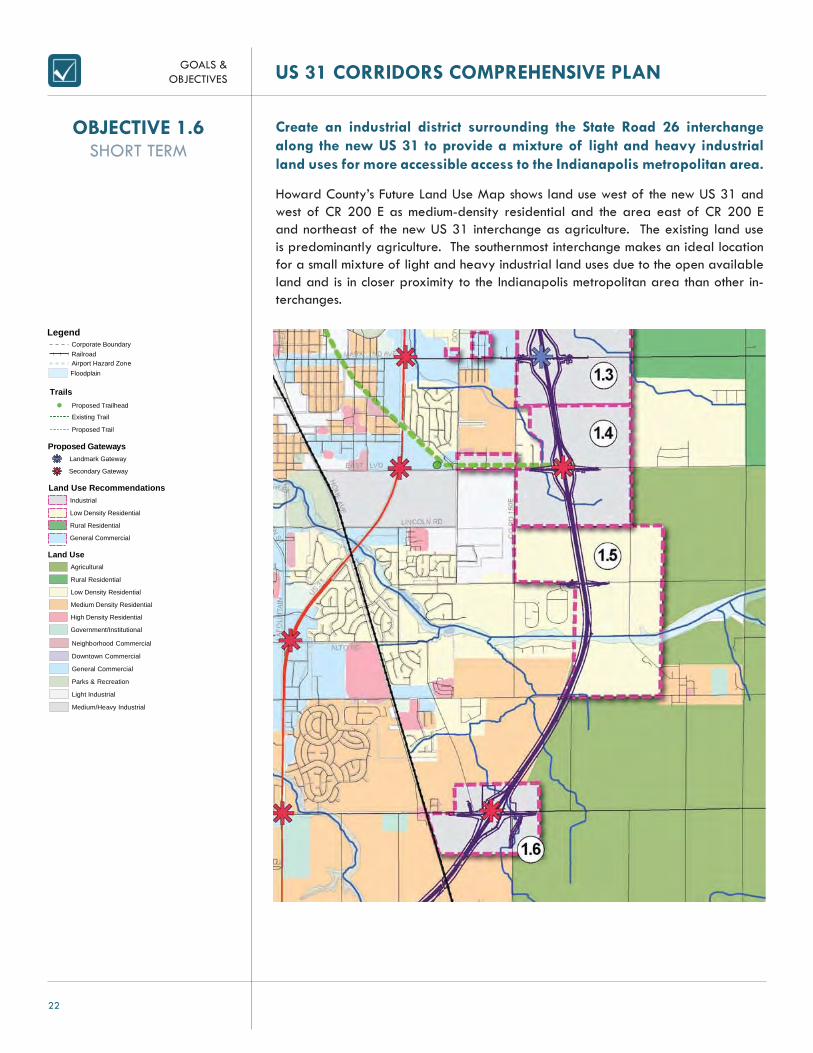
Create an industrial district surrounding the State Road 26 interchange along the new US 31 to provide a mixture of light and heavy industrial land uses for more accessible access to the Indianapolis metropolitan area.
Howard County’s Future Land Use Map shows land use west of the new US 31 and west of CR 200 E as medium-density residential and the area east of CR 200 E and northeast of the new US 31 interchange as agriculture. The existing land use is predominantly agriculture. The southernmost interchange makes an ideal location for a small mixture of light and heavy industrial land uses due to the open available land and is in closer proximity to the Indianapolis metropolitan area than other in-terchanges.
OBJECTIVE 1.6SHORT TERM
Legend
!( Proposed Trailhead
Proposed GatewaysLandmark Gateway
Existing Trail
Proposed Trail
Floodplain
Land Use RecommendationsIndustrial
Low Density Residential
Rural Residential
Land UseAgricultural
Rural Residential
Low Density Residential
Medium Density Residential
High Density Residential
Government/Institutional
Trails
Secondary Gateway
General Commercial
Neighborhood Commercial
Downtown Commercial
General Commercial
Parks & Recreation
Light Industrial
Medium/Heavy Industrial
Corporate BoundaryRailroadAirport Hazard Zone

GOALS &OBJECTIVES
23
US 31 CORRIDORS COMPREHENSIVE PLAN
Adopt appropriate zoning regulations for areas along the existing and new US 31 corridors to attract the desired land uses for those areas and improve and ensure aes-thetically attractive corridors.
GOAL 2

GOALS &OBJECTIVES US 31 CORRIDORS COMPREHENSIVE PLAN
24
Amend an overlay zone surrounding the new US 31 corridor that will en-sure the appropriate land use development for the entire area that is con-sidered a part of the new US 31 corridor and provides additional devel-opment regulations for signage, landscaping, parking, and architectural character.
An overlay zone is a regulatory tool that creates a special zoning district, placed over an existing base zone, which identifi es special provisions in addition to those in the underlying base zone. Regulations or incentives are attached to the overlay district to protect a specifi c resource or guide development within a special area. The US 31 Freeway overlay zone will provide development regulations for future growth within the future land use areas outlined within the plan and corridors adjacent to, and intersect with, the new US 31. By providing standards for future growth within the areas covered by the overlay zone, development will have unifying features to further enhance the aesthetic character along the corridor and help further identify the Kokomo community to travelers along US 31. (See Overlay Zone map on page larger map in Appendix)
The following are a list of development regulations that will be included in the new US 31 Overlay Zone:• Require interconnecting parking or shared parking to reduce parking lot size,
reduce curb cuts and improve traffi c safety. (Refer to Objective 2.4)• Require minimum density and minimum lot coverage to encourage more compact
development and desirable densities. (Refer to Objective 2.5)• Require front facing/oriented structures with rear parking requirements to im-
prove the physical conditions and aesthetics of big-box retails, strip centers and large commercial and industrial buildings. (Refer to Objective 2.6)
• Require four-sided architecture and differentiating building materials to break the monotony of continuous building facades. (Refer to Objective 2.7)
OBJECTIVE 2.1SHORT TERM

GOALS &OBJECTIVES
25
US 31 CORRIDORS COMPREHENSIVE PLAN
OBJECTIVE 2.2SHORT TERM
Adopt an overlay zone surrounding the existing US 31 corridor that will ensure the appropriate land use development for the entire area that is con-sidered the existing US 31 corridor and provides additional development regulations for signage, landscaping, parking, and architectural character.
The overlay zone will provide form-based code zoning with additional development regulations for signage, landscaping, parking, and architectural character as further described in Objective 2.3. The additional regulations within the overlay zone will help regulate form and create a more inviting corridor. The overlay zone is primarily made up of parcels immediately adjacent to the US 31 Bypass and along Markland Avenue in order to guide development in this area to follow form-based code design and create a more pedestrian scale, urban corridor. (See larger map in Appendix)

GOALS &OBJECTIVES US 31 CORRIDORS COMPREHENSIVE PLAN
26
Develop a multi-use form based zoning district to allow for more fl exibility in development while enhancing the placemaking value of new develop-ment along the existing US 31 corridor. (Refer to page 118 Form-Based Code for more information.)
Form-based zoning is a method of regulating development to achieve a specifi c urban form by controlling physical form primarily and, land uses secondarily. Cre-ating a form-based district along the existing US 31 corridor helps better address the relationship of the building to the streetscape and further create a unique sense of place. Form-based zoning provides for development that is compact, mixed-use, and pedestrian friendly. This type of development will help create a more aestheti-cally inviting corridor for visitors along US 31 and help to further create a brand for Kokomo’s primary commercial corridor. Graphic examples can be seen on pages 108-111. (See larger map in Appendix)
OBJECTIVE 2.3MEDIUM TERM
Example of a Regulatory Plan. A fi nalized and more detailed Regulatory Plan would be developed with the creation of the Form-Based Zoning Ordinance.

GOALS &OBJECTIVES
27
US 31 CORRIDORS COMPREHENSIVE PLAN
OBJECTIVE 2.4MEDIUM TERM
Modify parking requirements in existing and proposed zoning districts to reduce curb cuts and congestion and improve safety by requiring intercon-necting parking, shared parking and frontage roads for more effi cient land use confi gurations. (Refer to page 122 Shared Access Parking for more information.)
Shared access parking allows for two or more property owner, to agree to share a single driveway that accesses both or multiple properties and their adjacent parking lots. Consolidating and relocating driveways reduces the number of driveways along US 31, thus reducing the number of confl ict points for both vehicles and pedestrians at and between driveways, and helps traffi c move smoothly and safer along the corridor. If land is available, frontage roads connecting adjacent parking lots and providing primary access points along US 31, further reducing the number of confl ict points and reducing congestion.
Existing curb cuts and entrance drives along US 31 with four access points.
Example of interconnecting parking and shared-access parking with shared access to US 31 reducing access options and improving traffi c fl ow and safety.

GOALS &OBJECTIVES US 31 CORRIDORS COMPREHENSIVE PLAN
28
Modify density requirements in existing and proposed zoning districts to include minimum density and lot coverage requirements instead of maxi-mum densities to ensure appropriate and desirable development type and sizes.
Minimum-density regulations specify the minimum allowable development density in-stead of maximums to encourage more compact development. Studies of comprehen-sive plans often shows that setting maximum densities often results in lower densities actually being developed than what is desired in the plan. Minimum densities change the scenario and ultimately result in buildouts more in line with desired densities set by the community. Although this is not as effective or encouraged for commercial development, it is important to couple these regulations with mixed-use development standards. Oftentimes these regulations are more effective when combined with a “carrot” incentive, such as density bonuses that provide for more potential dwelling units to be developed on a site in exchange for trade-offs, such as additional public amenities, to be included as a portion of the development.
OBJECTIVE 2.5MEDIUM TERM

GOALS &OBJECTIVES
29
US 31 CORRIDORS COMPREHENSIVE PLAN
Modify building setback requirements in existing and proposed zoning districts to encourage more front-facing/oriented structures with rear park-ing requirements.
In order to mitigate the negative impacts of big-box businesses, strip centers and large commercial or industrial buildings along both the existing and new US 31 cor-ridors, zoning regulations can help improve the physical conditions and aesthetics of the buildings and site layout. By allowing smaller structures, or outlots, closer to the street with limited front bay parking, a more livable and inviting streetscape is cre-ated.
Example of an existing area along the US 31 Bypass with proposed outlots closer to street and the majority of parking in rear or on the side of the building.
Buildings oriented toward street corridor with rear parking at Hamilton Town Center in Noblesville, Indiana
OBJECTIVE 2.6MEDIUM TERM

GOALS &OBJECTIVES US 31 CORRIDORS COMPREHENSIVE PLAN
30
Add building guidelines in existing and proposed zoning districts to require four-sided architecture and building materials to improve the streetscape and aesthetics of the corridor.
In order to break the monotony of continuous building facades commonly found with big-box stores and strip centers along US 31, zoning regulations will encourage fa-çade articulation, treatment of solid walls with landscaping, and/or building material differentiation to add variety.
Example of four-sided architecture and building enhancements along the back of building with unassuming loading docks. Vancouver, Washington
Example of building articulation and additional architectural character on a big-box retailer. Ann Arbor, Michigan
Example of differentiating building materials and articulations on a commercial strip retail center. Indianapolis, Indiana
OBJECTIVE 2.7MEDIUM TERM

GOALS &OBJECTIVES
31
US 31 CORRIDORS COMPREHENSIVE PLAN
Establish redevelopment areas along the existing US 31 corridor that include industrial and commercial property for the purpose of directing potential redevelopment invest-ment.
GOAL 3

GOALS &OBJECTIVES US 31 CORRIDORS COMPREHENSIVE PLAN
32
Finalize the appropriate redevelopment area boundaries and complete a “Need for Redevelopment” study in order to declare redevelopment areas per Indiana Code.
Redevelopment areas provide redevelopment commissions with tools and the neces-sary authority to redevelop areas where market-driven development is impossible, undesirable, or under-utilized. In order for the Redevelopment Commission to act on redeveloping certain areas of the community, the “Need for Redevelopment” study , per IC 36-7-14, must fi nd that redevelopment within the area would not likely occur without the use of powers granted to the Redevelopment Commission. The “Need for Redevelopment” process includes:
• Determining need for redevelopment tools• Determining that the area is not likely to experience more development or
the area is under-utilized• Developing a legal description of the area• Developing a plan for revitalizing the area• Passing a declaratory resolution describing the intention to create a
redevelopment area and the plan of action• Holding a public hearing• Adopting a confi rmatory resolution/hearing including any modifi cations to
the original plan from public comments and the affected governmental units
Before picture of the Waterside Shopping commercial strip center.Marina del Rey, California
After picture of the Waterside Shopping Center redeveloped through the Marina del Rey Redevelopment Commission. Marina del Rey, California
OBJECTIVE 3.1SHORT TERM

GOALS &OBJECTIVES
33
US 31 CORRIDORS COMPREHENSIVE PLAN
Establish a TIF District to fund infrastructure improvements along the exist-ing US 31 Bypass.
Tax increment fi nancing allows economic development offi cials to collect property tax revenue from increased assessed values resulting from new investments within a designated area called the TIF District. A TIF district works by essentially freezing the amount of taxes that would typically be collected by other districts at the amount that was in effect when the district is formed. As assessed valuation of property within the district increases, the additional taxes that could be collected are paid to special district fund. This revenue collected can be used to pay for infrastructure and other improvements that directly benefi t the district. The TIF District must be designated as a redevelopment area, and the TIF Study should include:
• General boundaries of the area• Defi nition of the public purpose• Establishment of the tax allocation area• Plan for redevelopment of the area• Expected uses of TIF revenues
OBJECTIVE 3.2MEDIUM TERM

GOALS &OBJECTIVES US 31 CORRIDORS COMPREHENSIVE PLAN
34
Establish an Economic Improvement District along existing US 31 to help fi nancing improvements along the corridor that would enhance them-ing, placemaking, and marketing the US 31 commercial district. (Refer to page 116 Economic Improvement District for more information.)
An Economic Improvement District (EID) is an organizing and fi nancing mechanism used by property owners and merchants to determine the future of their retail, commercial, and industrial areas. The mechanism allows property owners and merchants to band together to use the county’s tax collection powers to assess properties, thereby creat-ing a reliable, multi-year source of funds for economic development. These funds are allocated to the City from the County and returned in their entirety to the EID and are used for supplemental services. An EID along the US 31 corridor could help create a branding identity for the corridor and further improve the aesthetics of the corridor. Common uses of EID monies include:
• Maintenance – trash collection, shoveling snow, cutting grass, trimming trees, planting fl owers
• Security and Hospitality – Hiring uniformed security, buying and installing electronic security systems, sidewalk tourism kiosks
• Consumer Marketing – Producing festivals and events, coordinating sales promotions, producing maps and newsletters, image enhancement and advertising campaigns, construct directional signage
• Business Recruitment and Retention – Market research, offering fi nancial incentives for new and expanding businesses, marketing to investors
• Public Space Regulation – Sidewalk widening, streetscape enhancements, street furniture
• Parking and Transportation Management – Maintain transit shelters, operate ride-sharing programs
• Urban Design – Develop urban design guidelines, manage façade improvement programs
• Social Services – Create/aid help-the-homeless, job training, youth service programs
• Visioning – Developing a vision or strategic plan• Capital Improvements – Install pedestrian-scale lighting and street furniture,
planting and maintaining trees and fl owers.
LEFT: Example of branding an Economic Improvement District in a Chicago neighborhood.Chicago, Illinois
RIGHT: Streetscape improvements made with revenue from an Economic Improvement District.Port Washington, Wisconsin
OBJECTIVE 3.3MEDIUM TERM
GOALS &OBJECTIVES
35
US 31 CORRIDORS COMPREHENSIVE PLAN
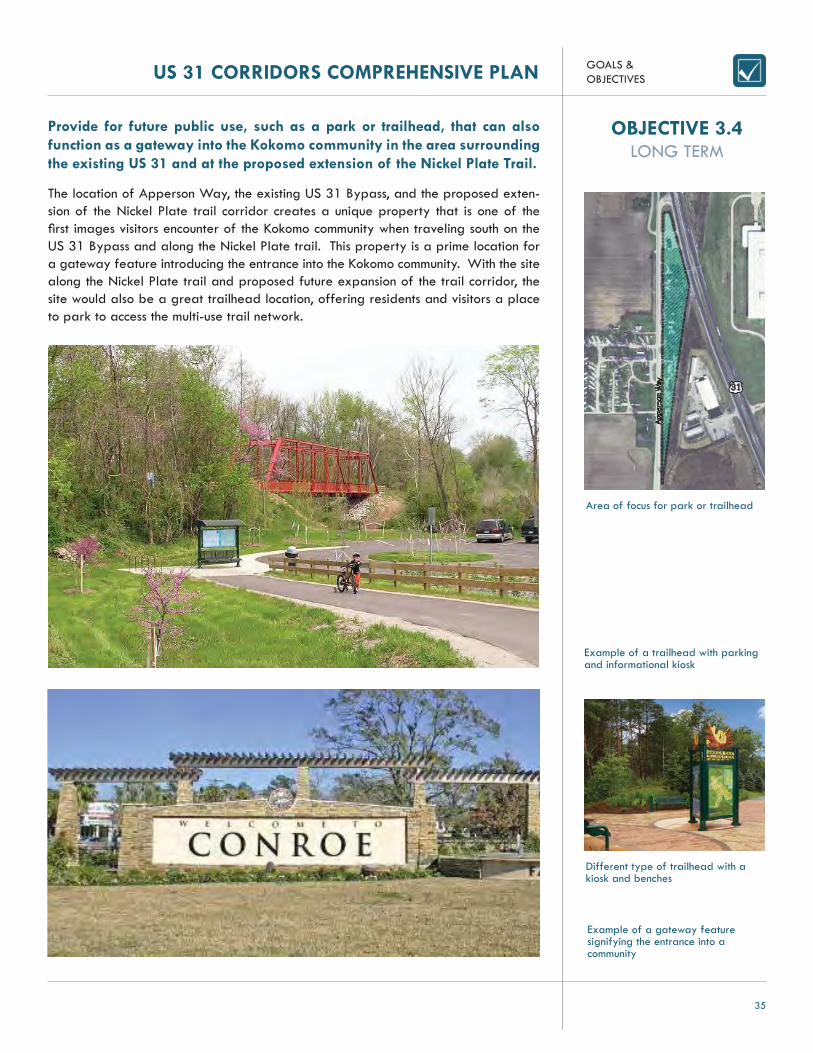
Provide for future public use, such as a park or trailhead, that can also function as a gateway into the Kokomo community in the area surrounding the existing US 31 and at the proposed extension of the Nickel Plate Trail.
The location of Apperson Way, the existing US 31 Bypass, and the proposed exten-sion of the Nickel Plate trail corridor creates a unique property that is one of the fi rst images visitors encounter of the Kokomo community when traveling south on the US 31 Bypass and along the Nickel Plate trail. This property is a prime location for a gateway feature introducing the entrance into the Kokomo community. With the site along the Nickel Plate trail and proposed future expansion of the trail corridor, the site would also be a great trailhead location, offering residents and visitors a place to park to access the multi-use trail network.
OBJECTIVE 3.4LONG TERM
Example of a gateway feature signifying the entrance into a community
Example of a trailhead with parking and informational kiosk
Different type of trailhead with a kiosk and benches
Area of focus for park or trailhead
31
App
erso
n W
ay

GOALS &OBJECTIVES US 31 CORRIDORS COMPREHENSIVE PLAN
36
Redevelop the area surrounding the intersection of existing US 31 and Morgan Street to north of the intersection of existing US 31 and Gano Street as a commercial node.
The area surrounding the intersection of Morgan Street and the existing US 31 Bypass is currently a mixture of commercial uses, including fast food restaurants and auto service businesses. The land available around this intersection provides devel-opment opportunity for cohesive commercial development with effi cient and safe access to the existing US 31 Bypass.
Example of general commercial within the same area as above with cohesive character, close to the street and pedestrian access
Example of neighborhood or general commercial center with parking on the side, landscaping, and pedestrian access
OBJECTIVE 3.5LONG TERM
Area of focus for commercial node development
31
Morgan Street
Gano Street
Ohi
o Str
eet
Coo
per
Str
eet

GOALS &OBJECTIVES
37
US 31 CORRIDORS COMPREHENSIVE PLAN
Attract new general commercial uses along the western side of existing US 31, northwest of the intersection of US 31 and Sycamore Street.
Currently, there are vacant properties northwest of the Sycamore Street and the existing US 31 Bypass intersection, including a vacant gas station with possible envi-ronmental contamination. The site provides excellent opportunities for general com-mercial uses that provide shared access off Sycamore Street.
Example of neighborhood/commercial center with outdoor seating to create more pedestrian atmosphere while still accommodating vehicular traffi c
Example of neighborhood/general commercial close to street, accommodating both pedestrian traffi c and vehicular traffi c
OBJECTIVE 3.6LONG TERM
Area of focus for new general commercial uses
31
Jefferson Street
Sycamore Street

GOALS &OBJECTIVES US 31 CORRIDORS COMPREHENSIVE PLAN
38
Attract mixed-use residential uses for the area surrounding the vacant Kroger store between Carter Street and Vaile Street.
The vacant Kroger store and surrounding properties along the existing US 31 Bypass between Carter Street and Vaile Avenue provide over 19 acres of opportunity for new development. The site, fronting US 31 with access on Carter Street and Vaile Avenue, creates an ideal location for mixed-use residential and commercial develop-ment. The proposed extension of the Walk of Excellence along the Wild Cat Creek and the available land north of Carter Street for potential park space further create a desirable location for residential use within walking distance.
Example of mixed use with a commercial center and higher-density residential within walking distance
Example of mixed use with big-box retailer mixed with offi ce space on second fl oors
Example of mixed use within a single building, commercial on ground fl oor and residential above
OBJECTIVE 3.7LONG TERM
Area of focus for mixed-use residential uses
31
Carter Street

GOALS &OBJECTIVES
39
US 31 CORRIDORS COMPREHENSIVE PLAN
Provide more opportunities for cohesive general commercial development east of existing US 31 to Belvedere Drive, between Vaile Avenue and Cart-er Street as a Redevelopment Area.
There are several access points along the existing US 31 Bypass between Markland Avenue and Carter Street contributing to one of the more congested areas along US 31. Belvedere Drive provides opportunity to access some of the parcels within the area, but due to the confi guration of parcels and lack of connecting driveways, most businesses cannot access Belvedere Drive and prefer to have direct access to US 31. Reconfi guring the parcels within this area provides over six acres of development opportunity. By reconfi guring parcels, access and safety can be increased by limit-ing direct vehicular access on US 31 and utilizing Belvedere Drive as an access road. Redeveloping this area will also provide opportunities for more cohesive design and character for general commercial uses further improving the aesthetics of the existing US 31 corridor.
Example of unifi ed character throughout commercial shopping center while offering green open space for pedestrians
OBJECTIVE 3.8LONG TERM
Area of focus for general commercial development
31
Bel
vede
re D
rive
Markland Avenue
Carter Street

GOALS &OBJECTIVES US 31 CORRIDORS COMPREHENSIVE PLAN
40
Provide more opportunities for mixed-use development or passive recre-ational opportunities in the area surrounding the vacant Speedway Gas Station west of existing US 31, north of Wheeler Street.
The vacant gas station along existing US 31, north of Wheeler street, creates rede-velopment opportunities for mixed-use development or recreational opportunities due to its close location to residential uses to the west and the existing US 31 corridor. Mixed-use development at this location would create an ideal transition between the surrounding residential uses and the more intense commercial corridor surrounding US 31. This area also would be ideal for a pocket park along the multi-use path pro-posed for the existing US 31 corridor and providing recreational opportunities to the surrounding residential uses.
Example of a gas station converted into a garden supply store
Example of a gas service station converted to a restaurant
Example of a small pocket park nestled within a neighborhood that provides seating and gardens
OBJECTIVE 3.9LONG TERM
Area of focus for mixed-use development or passive recreation
31
Wheeler Street
Firmin Street
Railroad Street

GOALS &OBJECTIVES
41
US 31 CORRIDORS COMPREHENSIVE PLAN
Attract general commercial uses by improving access to the area southeast of the intersection of existing US 31 and Alto Road, north of Albany Drive.
There are several access issues that have affected businesses along the eastern side of the existing US 31 Bypass between Alto Road and Albany Drive. The confi guration of parcels within the area prevents some businesses from having additional access to their properties from Albany Drive, leaving only right-in, right-out access along US 31. By reconfi guring the parcels within this area and providing all businesses with access to Alto Road, Albany Drive or Cartwright Drive would create better opportunities for successful general commercial uses.
Area of focus for improved access
OBJECTIVE 3.10LONG TERM

GOALS &OBJECTIVES US 31 CORRIDORS COMPREHENSIVE PLAN
42
Improve the condition of the site surrounding the intersection of existing US 31 and SR 26 for potential mixed-use development.
There are several vacant properties at this intersection with possible environmental issues making this a prime location for redevelopment. Mixed-use development in this area would create a transition of the primarily residential uses surrounding the intersection to the more intense commercial uses at the intersection. With several resi-dential neighborhoods in the area, neighborhood commercial uses at the intersection would provide residents access to retail rather than traveling further along the exist-ing US 31 corridor.
Area of focus for development potential
31
CR 400 S26
Meridian Park townhomes at 86th Street and Meridian Street in Indianapolis, oriented along both arterial streets with frontage road for access
OBJECTIVE 3.11LONG TERM

GOALS &OBJECTIVES
43
US 31 CORRIDORS COMPREHENSIVE PLAN
Provide general commercial development opportunities for the area sur-rounding Markland Avenue between Goyer Road and Lewis Street, and Foster Street to Arnold Street.
Markland Avenue is a prime commercial center for the Kokomo community, home to major big-box retail centers. The Markland Avenue interchange along the new US 31 Freeway corridor will increase traffi c along this corridor, making it ideal for more commercial growth. The current residential areas along Markland Avenue have drainage issues and are not serviced by the City. Demand for commercial space along Markland Avenue will increase with the new US 31 Freeway, making this area ripe for commercial redevelopment.
New CVS Pharmacy at 16th and Meridian in Indianapolis, an area with similar characteristics to Markland Avenue. The building is oriented to the street corner with the main entrance and parking oriented on the side of the building. Faux-mezzanine provides more proportionality to the streetscape.
The side of the store containing the garden center is designed to allow pedestrian access from the major roadway, with parking is in the rear.
OBJECTIVE 3.12LONG TERM
Area of focus for general commercial development
Emer
y W
ay
Markland Avenue

GOALS &OBJECTIVES US 31 CORRIDORS COMPREHENSIVE PLAN
44
GOAL 4
Establish identifi able nodes along the new and existing corridor to attract travelers to the Kokomo community through landmarks, landscaping enhancements, and ar-chitectural features.

GOALS &OBJECTIVES
45
US 31 CORRIDORS COMPREHENSIVE PLAN
Relocate the Kokomo visitor center to areas where the existing US 31 Bypass and new US 31 Freeway split from one another to increase aware-ness of the Kokomo community to visitors.
Members of the Kokomo Visitors Bureau were heavily involved throughout the public planning process. In order to increase visitor awareness about the Kokomo community and help direct visitors to the greater Kokomo area while traveling along the new US 31 Freeway, new visitor centers located where the new US 31 Freeway splits from the existing US 31 Bypass is recommended.
OBJECTIVE 4.1LONG TERM

GOALS &OBJECTIVES US 31 CORRIDORS COMPREHENSIVE PLAN
46
Create landmark gateways at the following locations to identify the en-trance to the Kokomo community along the new US 31 Freeway, and at-tract travelers to businesses within the community.
• Locations where the existing US 31 Bypass and new US 31 Free-way split from one another
• Markland Avenue interchange
Two landmark gateways are proposed where the new US 31 Freeway splits from the existing US 31 Bypass and one landmark gateway is proposed at the new US 31 Freeway interchange on Markland Ave. These gateways are envisioned to be a land-mark structure with landscaping, unique signage, and lighting that a visitor or resident will fi rst see along the US 31 corridors that signifi es the entrance to the Kokomo com-munity. These gateways also provide the opportunity for directional signage to direct traffi c from the new US 31 Freeway corridor to the existing US 31 Bypass corridor.
A statue related to the community helps identify the intersection as a community entrance feature
Unique bridge design at an interchange location sparks interest in travelers wondering what exists at the exit
Architectural monuments identify the area and intrigues visitors to further explore the area
OBJECTIVE 4.2MEDIUM TERM

GOALS &OBJECTIVES
47
US 31 CORRIDORS COMPREHENSIVE PLAN
Create secondary gateways along the new US 31 Freeway at the following locations to identify access to the Kokomo community for travelers along the corridor.
• East Boulevard interchange• SR 26 interchange
Secondary gateways are proposed along the new US 31 Freeway corridor and are slightly different than landmark gateways. These gateways can include landmark structures to signify the entrance to the Kokomo community on Markland Avenue and East Boulevard, but they may also include additional gateway features such as a mix-ture of land uses, unique architectural character, lighting, banners, directional signage, and landscaping. While these gateways are not as monumental as the landmark gateways, they still represent entrances into the Kokomo community and provide op-portunities to announce the travelers arrival into the community.
RIGHT: A simple pole with decorative detailing along the roadway lets visitors know they have arrived to your community
LEFT: A large monument acts as a gateway, fl anking the side of the street and also providing directional signage
A sign in the median acts as both a gateway to the community and offers directional signage to key locations in the area
OBJECTIVE 4.3MEDIUM TERM

GOALS &OBJECTIVES US 31 CORRIDORS COMPREHENSIVE PLAN
48
Create secondary gateways at the following intersections to help identify the existing US 31 Bypass corridor to travelers exiting and entering the new US 31 Freeway corridor.
• US 35 • Morgan Street • Sycamore Street • Markland Avenue • East Boulevard • Lafountain Street • SR 26
Secondary gateway are proposed along the existing 31 Bypass corridor and will in-clude features, such as a mixture of land uses, unique architectural character, lighting, banners, differentiating pavement, directional signage, and landscaping, to announce connections to important areas throughout Kokomo. The secondary gateways along the corridor will help improve the aesthetics of the corridor, help identify the impor-tance of the corridor as a commercial node, and also direct visitors to the greater Kokomo community.
Streetscape improvements such as landscaping can help further identify the corridor and beautify the roadway
A series of banners helps defi ne this part of the corridor
Differentiating pavement and landscaping at intersections act as a gateway and helps identify the area
OBJECTIVE 4.4MEDIUM TERM

GOALS &OBJECTIVES
49
US 31 CORRIDORS COMPREHENSIVE PLAN
GOAL 5
Change roadway classifi cations in the Thoroughfare Plan based on changes in transportation loads impacted by the new US 31 Freeway corridor to assure adequate capacity in the transportation network.

GOALS &OBJECTIVES US 31 CORRIDORS COMPREHENSIVE PLAN
50
Change the road classifi cation for CR 500 S, between the existing US 31 Bypass and CR 200 E, from a Local Road to a Minor Collector.
CR 500 S is currently classifi ed as a Local Road in the Howard County Thoroughfare Plan. Based on traffi c counts by the Kokomo/Howard County Governmental Coordi-nating Council in 2007, the annual average daily traffi c (AADT) count was 517. The Indiana Department of Transportation conducted a model to estimate 2030 AADT counts if the new US 31 Freeway was constructed and the impact the freeway would have on adjacent roadways. Based on this model it is estimated CR 500 S would have an AADT of 1,625 in 2030. Due to the projected AADT increase, CR 500 S should be classifi ed as Minor Collector. Future road improvements to CR 500 S should accom-modate for the increase in traffi c by ensuring a right-of-way width of 60 feet.
OBJECTIVE 5.1SHORT TERM
GOALS &OBJECTIVES
51
US 31 CORRIDORS COMPREHENSIVE PLAN
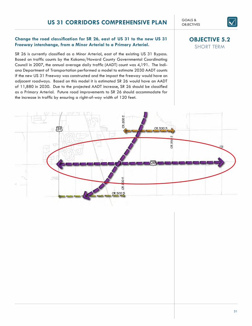
Change the road classifi cation for SR 26, east of US 31 to the new US 31 Freeway interchange, from a Minor Arterial to a Primary Arterial.
SR 26 is currently classifi ed as a Minor Arterial, east of the existing US 31 Bypass. Based on traffi c counts by the Kokomo/Howard County Governmental Coordinating Council in 2007, the annual average daily traffi c (AADT) count was 4,191. The Indi-ana Department of Transportation performed a model to estimate 2030 AADT counts if the new US 31 Freeway was constructed and the impact the freeway would have on adjacent roadways. Based on this model it is estimated SR 26 would have an AADT of 11,880 in 2030. Due to the projected AADT increase, SR 26 should be classifi ed as a Primary Arterial. Future road improvements to SR 26 should accommodate for the increase in traffi c by ensuring a right-of-way width of 120 feet.
OBJECTIVE 5.2SHORT TERM

GOALS &OBJECTIVES US 31 CORRIDORS COMPREHENSIVE PLAN
52
Change the road classifi cation for CR 300 S, from CR 200 E to CR 350 E from a Minor Collector to a Major Collector.
CR 300 S is currently classifi ed as a Minor Collector in the City of Kokomo Thorough-fare Plan. Based on traffi c counts by the Kokomo/Howard County Governmental Coordinating Council in 2007, the annual average daily traffi c count (AADT) was 3,127. The Indiana Department of Transportation performed a model to estimate 2030 AADT counts if the new US 31 Freeway was constructed and the impact the freeway would have on adjacent roadways. Based on this model it is estimated CR 300 S would have an AADT of 4,246 in 2030. Due to the projected AADT in-crease, CR 300 S should be classifi ed as Major Collector. Future road improvements to CR 300 S should accommodate for the increase in traffi c by ensuring a right-of-way width of 80 feet.
OBJECTIVE 5.3SHORT TERM

GOALS &OBJECTIVES
53
US 31 CORRIDORS COMPREHENSIVE PLAN
Change the road classifi cation for CR 100 S (Boulevard), from Webster Street to CR 300 E, from a Major Collector to a Minor Arterial.
CR 100 S is currently classifi ed as a Major Collector in the City of Kokomo Thorough-fare Plan. Based on traffi c counts by the Kokomo/Howard County Governmental Coordinating Council in 2007, the annual average daily traffi c (AADT) count was 5,046. The Indiana Department of Transportation performed a model to estimate 2030 AADT counts if the new US 31 Freeway was constructed and the impact the freeway would have on adjacent roadways. Based on this model it is estimated CR 100 S would have an AADT of 9,130 in 2030. Due to the projected AADT increase, CR 100 S should be classifi ed as Minor Arterial from Webster Street toCR 300 E. Future road improvements to CR 100 S should accommodate for the in-crease in traffi c by ensuring a right-of-way width of 100 feet.
OBJECTIVE 5.4SHORT TERM

GOALS &OBJECTIVES US 31 CORRIDORS COMPREHENSIVE PLAN
54
Change the road classifi cation for Touby Pike from the new US 31 Freeway northern interchange ramp to CR 300 N, from a Major Collector to a Minor Arterial.
Touby Pike is currently classifi ed as a Major Collector in the City of Kokomo Thor-oughfare Plan. Based on traffi c counts by the Kokomo/Howard County Governmental Coordinating Council in 2007, the annual average daily traffi c (AADT) count was 855. The Indiana Department of Transportation performed a model to estimate 2030 AADT counts if the new US 31 Freeway was constructed and the impact the freeway would have on adjacent roadways. Based on this model it is estimated Touby Pike would have an AADT of 6,010 in 2030. Due to the projected AADT increase, Touby Pike should be classifi ed as Minor Arterial from the new northern US 31 interchange ramp to CR 300 N. Future road improvements to Touby Pike should accommodate for the increase in traffi c by ensuring a right-of-way width of 100 feet.
OBJECTIVE 5.5SHORT TERM

GOALS &OBJECTIVES
55
US 31 CORRIDORS COMPREHENSIVE PLAN
Add the new US 31 Freeway to the Thoroughfare Plan as a primary arte-rial.
The new US 31 Freeway is a limited-access interstate roadway with fi ve interchanges. The limited-access design will allow for free fl owing traffi c to travel through the Koko-mo area and will be the primary corridor for travelers along US 31 from Indianapolis to South Bend. Through traffi c modeling, the Indiana Department of Transportation forecasts the US 31 Freeway will have an average annual daily traffi c count of ap-proximately 28,000, classifying the roadway as a Major Arterial.
OBJECTIVE 5.6SHORT TERM

GOALS &OBJECTIVES US 31 CORRIDORS COMPREHENSIVE PLAN
56
GOAL 6
Improve the aesthetics and function of the existing US 31 corridor to create a more context sensitive urban boulevard in order to function in a primarily urban area, improve com-mercial viability, and provide for full multimodal accessibil-ity and functionality for all types of traffi c.
Proposed typical section of existing US 31 Bypass with streetscape enhancements to create an urban boulevard.
Implement a unifi ed streetscape design along existing US 31 that will in-clude banners, landscaping, lighting features, and public art to improve the aesthetics of the corridor and help increase retail sales.
Creating a strong sense of place is important in terms of developing appealing re-tail destinations for consumers, as well as appealing and attractive communities, for residents and businesses alike. Creating a shopping destination includes developing a visual system to help users determine when they are within the district as well as ways to help fi nd their way around. Although there is no single recipe for creating a successful place, consideration of the following elements throughout the corridor are important in defi ning the existing US 31 Bypass corridor:
• A unifi ed color scheme between street furniture, banners, art, and logos to help provide subtle visual cues to users as to their location
• Coordinated street furniture, such as benches, trash receptacles, transit shel-ters, bicycle racks, and other elements in terms of style and color. Privately provided elements, such as restaurant seating, should also be coordinated through covenants or development ordinances
• The use of common landscaping themes, such as a common planting palate and use of certain ornamental species, can be used
• The use of banner poles in combination with ornamental public lighting along the thoroughfares can allow for advertising of events but also provides for opportunities to create signage that can contribute to district placemaking
• Ornamental public lighting of vehicle and pedestrian thoroughfares should maintain a consistent look and feel within a district. Varying the use of or-namental styles can help differentiate different districts and neighborhoods from one another
• Public art opportunities, such as murals, sculpture, or elements in sidewalks or crosswalks, can be themed in a manner to help identify a district or place
OBJECTIVE 6.1LONG TERM

GOALS &OBJECTIVES
57
US 31 CORRIDORS COMPREHENSIVE PLAN
Create crosswalks and pedestrian refuges at each intersection along the existing US 31 Bypass to provide safe and effi cient pedestrian access throughout the corridor.
Constructing sidewalks and multi-use side paths creates a pedestrian-friendly envi-ronment along the existing US 31 Bypass corridor, encouraging people to walk and ride bicycles. With over 15 signalized intersections and over 100 access points, along with approximately 108 feet of right-of-way width to cross existing US 31, safety for pedestrians moving throughout the corridor is extremely important. Each intersection and access drive along existing US 31 should have crosswalks for pedes-trians. The distance to safely cross existing US 31 is too large for pedestrian and bicycles in one signaled crossing period; therefore, pedestrian refuges are needed in the median for pedestrians to wait safely for the next signaled crossing.
31
31
PEDESTRIAN REFUGE
Graphic showing an intersection of the existing US 31 Bypass with pedestrian refuges
Constructed pedestrian refuge at an intersection
Aerial view of an intersection with pedestrian refuges and differentiating pavement for crosswalks
OBJECTIVE 6.2LONG TERM

GOALS &OBJECTIVES US 31 CORRIDORS COMPREHENSIVE PLAN
58
Create mid-block crosswalks and pedestrian refuges where proposed multi-use trails cross the existing US 31 Bypass to provide safe and ef-fi cient pedestrian access along the trail network.
Three multi-use trails are proposed that will cross the existing US 31 Bypass. To en-sure the safety of pedestrians crossing the corridor which is approximately 108 feet wide, pedestrian refuges should be constructed in the median of the US 31 corridors where trails cross. This allows for pedestrians to cross two lanes of traffi c at one time as opposed to four lanes and also allows for vehicles to be more aware of present pedestrians before they cross. Each trail crosswalk along the corridor should include differentiating pavements, stripes, yellow fl ashing lights and caution signs to alert motorists of pedestrians and ensure the safety of trail users.
Example graphic of a mid-block crosswalk with pedestrian refuge for trails crossing US 31
Aerial view of pedestrian refuge
PEDESTRIAN REFUGE
31TRAIL
TRAIL
OBJECTIVE 6.3MEDIUM TERM
GOALS &OBJECTIVES
59
US 31 CORRIDORS COMPREHENSIVE PLAN
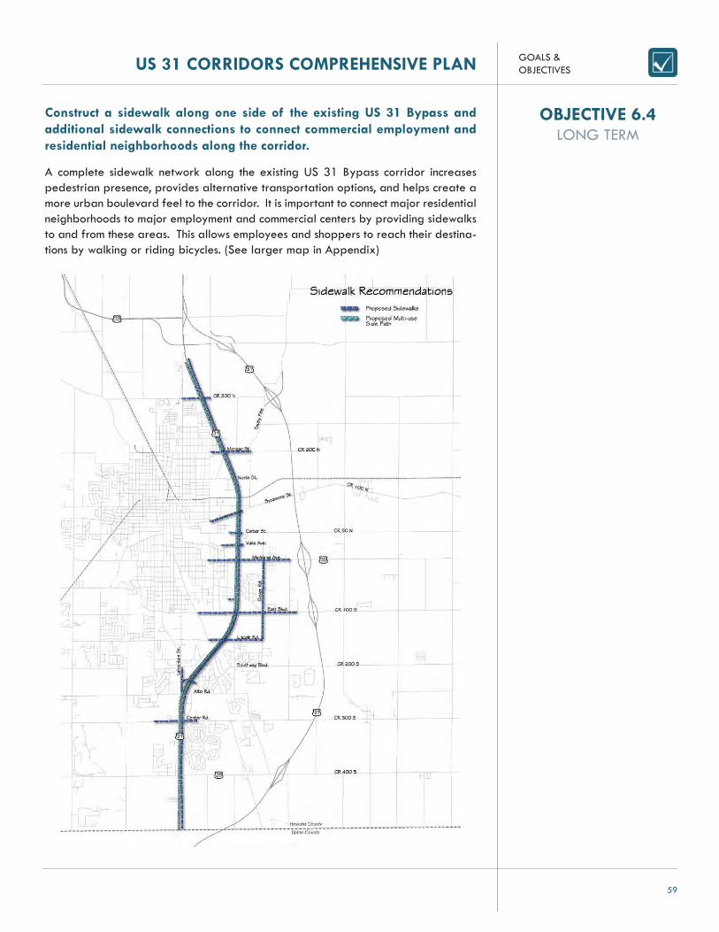
Construct a sidewalk along one side of the existing US 31 Bypass and additional sidewalk connections to connect commercial employment and residential neighborhoods along the corridor.
A complete sidewalk network along the existing US 31 Bypass corridor increases pedestrian presence, provides alternative transportation options, and helps create a more urban boulevard feel to the corridor. It is important to connect major residential neighborhoods to major employment and commercial centers by providing sidewalks to and from these areas. This allows employees and shoppers to reach their destina-tions by walking or riding bicycles. (See larger map in Appendix)
OBJECTIVE 6.4LONG TERM

GOALS &OBJECTIVES US 31 CORRIDORS COMPREHENSIVE PLAN
60
Construct a multi-use side path along the entire length of the existing US 31 Bypass corridor between SR 26 and North. Apperson Way to ensure the safe travel of pedestrians and bicycles.
A bicycle side path is a bicycle facility that follows and is immediately adjacent to a roadway. A bicycle side path can be a dedicated facility for bicyclists only, similar to an on-street bicycle lane, or it can operate as a shared-use facility that can also accommodate pedestrians. Bicycle side paths are typically used on thoroughfares where traffi c volume, on-street parking confi gurations or other potential dangerous hazards exist, making on-street bicycle facilities a less desirable option.
The existing US 31 corridor currently lacks both pedestrian and bicycle facilities to allow for pedestrian movement along the corridor and between the residential neighborhoods and retail areas of the corridor. Pedestrians are observed negotiat-ing pathways through parking lots and across adjacent roadways without adequate protection and separation from automobile traffi c. Current traffi c counts along the corridor make bicycle riding for many recreational riders very diffi cult and danger-ous due to traffi c speeds and the many uncontrolled access points along the corridor.
The current right-of-way could accommodate a shared-use side path along the cor-ridor, creating a safer avenue for pedestrians and bicyclists along the corridor. Many communities see an increase in pedestrian and bicycle traffi c with the installation of these facilities.
The bicycle side path (on the left) is at the same grade as the sidewalk.Indianapolis, Indiana.
The two-way bicycle side path is grade separated from the sidewalk to provide for separation between bicycles and pedestrians.Montreal, Canada
OBJECTIVE 6.5LONG TERM

GOALS &OBJECTIVES
61
US 31 CORRIDORS COMPREHENSIVE PLAN
Construct sidewalks along both sides of Markland Avenue between Coo-per Street and the new US 31 Freeway.
Markland Avenue is Kokomo’s secondary commercial corridor following the existing US 31 corridor. Several big-box retailers are located along Markland Avenue east of US 31, and with the new interchange along the new US 31 Freeway as a landmark gateway into the community, more commercial businesses will locate along Markland Avenue. To ensure this corridor accommodates pedestrians, sidewalks should be con-structed along both sides of Markland Avenue between Cooper Street and the new US 31 Freeway. Sidewalks along this corridor will allow for employees and shoppers to have an additional mode of transportation to the area and connect to the larger sidewalk network connecting the Kokomo community.
Sidewalks along road connecting to commercial retail center
OBJECTIVE 6.6MEDIUM TERM

GOALS &OBJECTIVES US 31 CORRIDORS COMPREHENSIVE PLAN
62
BELOW: Existing US 31 cross-section
OBJECTIVE 6.7LONG TERM
Curb inlets into bioswale along Main Street in Speedway, Indiana. Overfl ow mechanism drains into traditional stormwater system in the case of large rain events.
Narrow lane widths along the existing US 31 corridor to reduce vehicle speeds without impacting traffi c volume and decrease pavement crossing to improve safety for pedestrians.
Maintaining effi cient traffi c fl ow on the existing US 31 Bypass is important. The ex-isting US 31 Bypass roadway cross-section has over 30 feet of shoulder, 48 feet of travel lanes and 40 feet of median. The pavement widths are even greater at inter-sections with the addition of turning lanes. The 12 foot wide travel lanes encourage greater vehicle speeds while the number of existing traffi c signals constrain speeds. Engineering studies have found that slight reductions in lane widths decrease vehicle speeds while not reducing traffi c volumes signifi cantly. Reducing lane widths to 11 feet and replacing existing open-shoulder sections with curb and gutter would reduce travel lane widths to 44 feet and replace the shoulders with 4 foot of curbs and gut-ter. It should reduce traffi c speeds while maintaing traffi c fl ow. In addition, it would provide room for converting the median to a boulevard and for adding sidewalks and multi-use paths along the road.
In addition, the excessive pavement widths creates barriers for pedestrians crossing the US 31 Bypass by increasing vehicle speed and increasing the distance a pedes-trian must cross. The current width of the US 31 corridor is a barrier to pedestrian interchange and hurts the benefi cial community and economic activity that comes with pedestrian movement. Reducing travel lane widths have a major impact on improving pedestrian crossing safety.
The current existing US 31 design facilitates drainage of stormwater from the road-way by draining into open drainage swales located in the median and on each side of the roadway. The addition of curbs, which eliminates the need for wide shoulders, would mean developing new systems for collecting stormwater. The traditional op-tion is a closed conveyance system that involves curb inlets and storm sewer that would discharge into a body of water after removing sediment through treatment mechanisms. An alternative to this approach would be the use of rain gardens and bioswales in combination with curb cuts that allow the stormwater to fl ow into these systems. These swales and depressed collection areas include engineered soils to help facilitate absorption of stormwater into the groundwater table, as well as vegetation that is tolerant to fl ooding. These systems are very effective at reducing stormwater discharge and improving the water quality of stormwater that is discharged into lo-cal streams and water bodies. Appropriate sizing is necessary to ensure adequate capacity for stormwater storage and treatment. These systems can often be combined with traditional stormwater conveyance systems and work to reduce the size and cost of the traditional system.
ABOVE: Bioswale along California highway with open shoulder section

GOALS &OBJECTIVES
63
US 31 CORRIDORS COMPREHENSIVE PLAN GOALS &OBJECTIVES
63
US 31 CORRIDORS COMPREHENSIVE PLAN
Proposed closed storm water system along the US 31 Bypass
Elevated median with roll curb and dense plan ngs
Decora ve light polesde ne parkway and district
(2) 11’ Travel Lanes
4’ Shoulder
Open drainage area graded lesssteep to allow for plan ngs
Proposed open drainage system along the US 31 Bypass
GOALS &OBJECTIVES US 31 CORRIDORS COMPREHENSIVE PLAN
64
Consider reducing the speed limit along the existing US 31 Bypass to in-crease pedestrian safety while preventing negative impacts on traffi c vol-ume.
New sidewalks, cycle track, crosswalks, and pedestrian refuges along the existing US 31 Bypass will increase the amount of pedestrians using these facilities and cross-ing roads. To better prevent pedestrian-vehicle confl icts and ensure pedestrian safe-ty along the US 31 corridor, it is important to consider reducing the speed limit along the corridor. The speed limit for a majority of the US 31 Bypass is currently 45 mph. The speed of vehicles involved in pedestrian impacts is a major determinant of the severity and outcome of injury. The National Highway Traffi c Safety Administration determined deaths to injuries were nine times higher where the speed limit is 55 mph as on roads where it is 30 mph or lower for pedestrian-vehicle confl icts.
OBJECTIVE 6.8LONG TERM
GOALS &OBJECTIVES
65
US 31 CORRIDORS COMPREHENSIVE PLAN
Add a street canopy along the existing US 31 corridor to improve aesthet-ics, safety for pedestrians, retail sales, and traffi c calming and further en-hance the look and feel of an urban boulevard.
Reintroducing street trees into the existing US 31 corridor can have the following posi-tive impacts:• Trees have a positive impact on the environment and climate by reducing carbon
dioxide in the atmosphere and lowering air temperature due to transpiration and shade.
• Numerous studies have shown that urban trees have a positive correlation with public health, offi ce rental rates, and consumer spending.
• Trees are an important ingredient in traffi c calming. Mature trees along roadways create vertical elements which subconsciously cause drivers to reduce their speeds. This is important when increasing safety for pedestrians. Street trees can have up to a 20-percent impact on traffi c speeds with very little impact on volume.
When reintroducing trees into the corridor, it is important to consider engineering best-practices to ensure trees do not present undue hazards to vehicles; create line-of-sight problems for drivers, especially in pedestrian crossing areas; or create impediments for pedestrians and drivers to see retail signage and wayfi nding. Maintaining line-of-sight to retail establishments is important in maintaining a healthy corridor.
AASHTO Transportation Research Board and the Institute for Transportation Engineers have outlined a number of areas to consider:• The set speed limit of the new corridor should not exceed 45 mph. The slower
speeds are safer for pedestrians but also improve retail sales by allowing driv-ers to absorb more information from signage and spotting retail establishments. Faster speeds increase the risk of serious injury from driver-tree confl icts.
• Maintaining sight-lines and offsets from the curb are important. Trees should be maintained and pruned for this purpose. Trees should be planted in medians no closer than 50 feet from intersections.
• Continuous canopies can be created with tree plantings between 15 and 30 feet on-center, depending upon species selection
Many shade and ornamental trees are being bred to create different canopy con-fi gurations. Although wider canopies are appropriate in some areas, more conical canopies, while generating less canopy cover, will allow more line of sight to retail businesses.
It is important to consult an urban forester, arborist, or landscape architect before beginning a tree-planting program to select a palette most appropriate for the area the tree is being planted. It is important the street trees be able to handle the climate, drought tolerance, disease resistance and salt tolerance. Good street trees that have these characteristics include (native are denoted with “*”):• Hedge Maple• Nikko Maple• Turkish Filbert• Cockspur Hawthorn*• Washington Hawthorn*• Winter King Green Hawthorn*
OBJECTIVE 6.9LONG TERM

GOALS &OBJECTIVES US 31 CORRIDORS COMPREHENSIVE PLAN
66
• Hardy Rubber• Amur Maackia• Hop Hornbeam*• Callery Pear• Amur Maple• Paperbark Maple• Tartarian Maple• Pagoda Dogwood*• Kousa Dogwood• Japanese Tree Lilac
Good larger shade trees that can be interspersed within a project to give greater canopy include:• Freeman Maple• Red Horse Chestnut• White Ash* (should not be planted in large quantities due to Emerald Ash Borer)• Honeylocust*• Black Gum *• Sycamore*• London Planetree
The Washington Hawthorn, a medium-sized ornamental tree, in sidewalk plantings along Reading Road in Cincinnati, Ohio

GOALS &OBJECTIVES
67
US 31 CORRIDORS COMPREHENSIVE PLAN
Create a regionally recognizable commercial shopping district by imple-menting a branding program for the commercial district along the existing US 31 Bypass corridor to unify marketing and create awareness for the district and commercial entities.
Although “branding” is a buzz word across marketing and economic development circles, it is a process that can have great benefi ts when developing retail or destina-tion-based districts. Shoppers come from a multi-county market to shop the businesses along the existing US 31 Bypass corridor. Creating an image that can be used for common advertising and marketing and incorporated into the urban design of the district can help increase retail traffi c.
An effective branding program needs to consider the following elements:• Understands the target markets• Makes a promise based upon the assets of the community that can be
offered• Resonate with the target market and does not sound like it could work for
“Anyplace USA”
The branding process should include stakeholder input throughout the existing US 31 corridor district, including business owners, city offi cials, and economic development offi cials. It is important the branding program have buy-in, as consistency and staying on message will be important to its overall success.
LEFT: Branding strategy for the Lawrenceville neighborhood of Pittsburgh, Pennsylvania based upon an arts theme
CENTER & RIGHT: The City of Indianapolis and Indianapolis Downtown Inc. created a branding strategy for various downtown districts and Broad Ripple as destination areas
OBJECTIVE 6.10LONG TERM

GOALS &OBJECTIVES US 31 CORRIDORS COMPREHENSIVE PLAN
68
Maintain the Norfolk Southern (Nickel Plate) rail line as a rail corridor to ensure future opportunities for commuter rail services between Kokomo and Indianapolis.
The Norfolk Southern line (former Nickel Plate), while not active track, is still owned and operated by Norfolk Southern Railroad. This line eventually heads south through Tipton County and connects with Noblesville and Indianapolis. This segment of track between Noblesville and Indianapolis has been identifi ed in studies by the Indianapo-lis Metropolitan Planning Organization as a “new starts route” for commuter railroad into Indianapolis.
The City of Kokomo has an interest in maintaining the viability of this corridor for both recreational and future transportation purposes. The corridor connects northward with existing plans for future slated rail trails and serves as a logical extension south of downtown. As commuter rail is established to serve Indianapolis, a logical extension of that service would be northward to the city of Kokomo, with the current alignment as most direct route between Kokomo and Indianapolis. Maintaining existing track, crossings, and property for the route is important in ensuring future viability for these purposes. Plans for future roadway improvements, including the new US 31 Freeway, should maintain existing crossings or consider grade separation to ensure viability for future rail travel. The City should be prepared to acquire railroad property if Norfolk Southern Railroad moves to divest its interest in this corridor.
Norfolk Southern line as seen from CR 200 S
OBJECTIVE 6.11 SHORT TERM

GOALS &OBJECTIVES
69
US 31 CORRIDORS COMPREHENSIVE PLAN
Ensure future development and road design accommodate future transit stops to further expand and plan for future transit options.
Although the City does not currently operate fi xed-route bus transit, it is a use that may need to be accommodated in the future. Design for the existing US 31 corridor should take into account potential locations for transit stops and accommodate pull-offs for staging areas, as well as locations within the right-of-way for transit stop shelter facilities.
TOP LEFT: Transit shelter in Phoenix, Arizona, that was also an opportunity to utilize a public art piece
BOTTOM LEFT: Proposed bus pull-off with transit stop along arterial thoroughfare in Valparaiso, Indiana
Possible bus pull-off and shelter location along US 31
OBJECTIVE 6.12LONG TERM

GOALS &OBJECTIVES US 31 CORRIDORS COMPREHENSIVE PLAN
70
GOAL 7
Increase recreational opportunities and connections throughout the community, such as Wildcat Creek, Nick-el Plate Trail, Walk of Excellence and Kokomo Reservoir, while maintaining and protecting sensitive watersheds.
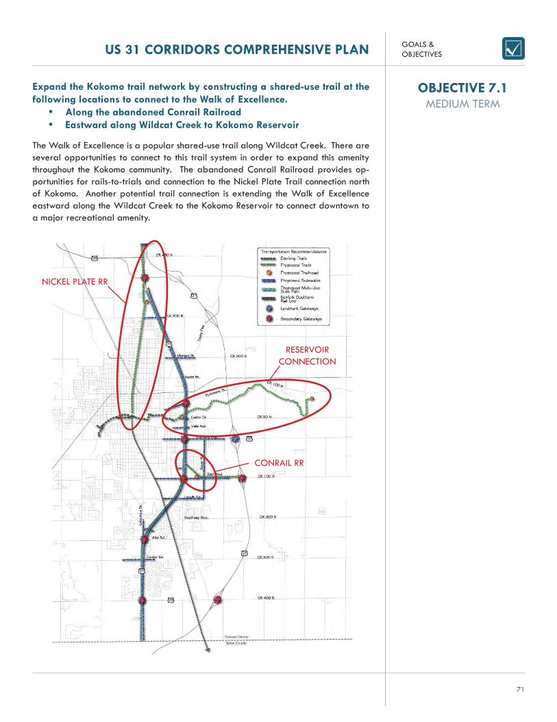
GOALS &OBJECTIVES
71
US 31 CORRIDORS COMPREHENSIVE PLAN
Expand the Kokomo trail network by constructing a shared-use trail at the following locations to connect to the Walk of Excellence.
• Along the abandoned Conrail Railroad• Eastward along Wildcat Creek to Kokomo Reservoir
The Walk of Excellence is a popular shared-use trail along Wildcat Creek. There are several opportunities to connect to this trail system in order to expand this amenity throughout the Kokomo community. The abandoned Conrail Railroad provides op-portunities for rails-to-trials and connection to the Nickel Plate Trail connection north of Kokomo. Another potential trail connection is extending the Walk of Excellence eastward along the Wildcat Creek to the Kokomo Reservoir to connect downtown to a major recreational amenity.
RESERVOIR CONNECTION
NICKEL PLATE RR
CONRAIL RR
OBJECTIVE 7.1MEDIUM TERM

GOALS &OBJECTIVES US 31 CORRIDORS COMPREHENSIVE PLAN
72
Construct trailheads at the following locations along the proposed eastern extension of the Walk of Excellence along Wildcat Creek to provide for ca-noeing access and for pedestrians to access the shared-use trail.
• Northwest of the intersection of CR N400 E and CR E50 N• Northwest of the intersection of the existing US 31 and Carter
Street
The proposed locations for these trailheads were selected based on criteria such as trail location, proximity to the Wildcat Creek, available land, and access to the US 31 corridors. The trailheads are intended to be the point at which trail users can enter or exit from the shared-use trail and may include elements such as parking, restrooms, ki-osks, and other public facilities. Trailhead facilities (typically one to two acres) include appropriate facilities, such as parking, restrooms, drinking fountains, and kiosks, but trailheads can differ in size and the amount of amenities provided. These trailhead locations are also intended to provide canoeing and kayaking access along Wildcat Creek to expand access to this recreational opportunity.
The Waterworks Dam along the Wildcat Creek creates an obstacle for canoeists or kayakers using the river. A portage, a designated place where canoeists and kayak-ers can carry their watercraft over land to avoid river obstacles, is needed to make the river accessible on both sides of the dam. There currently is not a dedicated portage and one is needed to enhance the Wildcat Creek as a recreational amenity. The construction of a portage can be incorporated into the trailhead at the northwest intersection of the existing US 31 and Carter Street.
OBJECTIVE 7.2MEDIUM TERM

GOALS &OBJECTIVES
73
US 31 CORRIDORS COMPREHENSIVE PLAN
Construct trailheads along the proposed extension of the Nickel Plate Trail to provide for pedestrian access for the shared-use trail.
• Southwest of the intersection of US 31 and Apperson Way• Northwest of the intersection of the abandoned Conrail Railroad
and East Boulevard
The proposed locations for these trailheads were selected based on criteria such as trail location, available land, and access to the US 31 corridors. The trailheads are intended to be the point at which trail users can enter or exit from the shared-use path and may include elements such as parking, restrooms, kiosks, and other public facili-ties. Trailhead facilities (typically one to two acres) include appropriate facilities, such as parking, restrooms, drinking fountains, and kiosks, but trailheads can differ in size and the amount of amenities provided.
OBJECTIVE 7.3MEDIUM TERM

GOALS &OBJECTIVES US 31 CORRIDORS COMPREHENSIVE PLAN
74
GOAL 8Provide adequate sanitary and storm sewers to future land use areas targeted for growth in order to attract shovel-ready development.

GOALS &OBJECTIVES
75
US 31 CORRIDORS COMPREHENSIVE PLAN
Extend sewer service to the future light industrial development area sur-rounding the SR 26 interchange along the new US 31.
Extend sewer service to the future industrial development area along the western edge of US 31 and east of the Kokomo corporate limits, between the Touby Pike interchange and the CERA railroad.
Extend sewer service, add a new pump station and upgrade Apperson Way Pump Station to provide for future industrial development north of the new US 31 interchange at CR RD E 450 N and CR N 50 E.
Extend sewer service, and add a new pump station to provide for future industrial development surrounding the new US 31 interchange locations at Markland Avenue and East Boulevard.
Extend sewer service and build a new pump station to provide service along the New US 31 corridor between Center Road and north of CR 200 S to provide for future low density residential development.
OBJECTIVE 8.1MEDIUM TERM
OBJECTIVE 8.2MEDIUM TERM
OBJECTIVE 8.3LONG TERM
OBJECTIVE 8.4LONG TERM
OBJECTIVE 8.5LONG TERM


PLANS & STUDIES

PLANS & STUDIES US 31 CORRIDORS COMPREHENSIVE PLAN
78
REVIEW OF PLANS AND STUDIESSeveral studies were conducted throughout the planning process to better understand and analyze the existing and future conditions of both the new US 31 Freeway cor-ridor and the existing US 31 Bypass corridor. Studies conducted included:
• Site Analysis and Existing Land Use• Market Analysis• Public Involvement Process• Utilities• Suitability Analysis
SITE ANALYSIS AND EXISTING LAND USE
DISTRICT AThe Chrysler buildings along existing US 31 north of Smith Road create a heavy industrial campus and acts as a northern gateway to Kokomo. Two detention basins located east of the Chrysler plant provide stormwater management to the area. The intersection at existing US 31 and Apperson Way marks the beginning of the existing US 31 Bypass. The intersection at existing US 31 and Smith Road is classifi ed as a secondary intersection due to the proximity of the multiple Chrysler buildings.
The architecture of existing US 31 between Smith Road and US Highway 35 is pri-marily industrial in nature. There are two Chrysler plants located on the east side of US 31 north of Smith Road. These buildings are 13 years old and appear to be well maintained (See Figures A.01 and A.02 as shown). Businesses like Lucas Family Furniture and Carter Lumber are located within this area of existing US 31. These buildings are generally well maintained as shown in Figure A.03, but there are some derelict buildings and under-maintained businesses throughout this area. The Kokomo Assembly of God Korean Church, located just south of Carter Lumber, appears to be well maintained as shown in Figure A.04. This church appears to be a converted 89-year-old residence. US 31 between US 35 and CR W 550 N is primarily residen-tial and agricultural in nature.
LEFT: Figure A.01
RIGHT: Figure A.02

US 31 CORRIDORS COMPREHENSIVE PLAN
US 31 CORRIDORS SITE ANALYSIS
PLANS & STUDIES
79

PLANS & STUDIES
80
US 31 CORRIDORS COMPREHENSIVE PLAN
LEFT: Figure A.03
RIGHT: Figure A.04
Residential neighborhoods throughout the studied area vary in size, age, architectural style and type, and acreage of property. Houses vary between well maintained, neglected, and vacant. Each residence facing US 31 should be analyzed on a case-by-case basis for a more in-depth analysis. Houses like those shown in Figures A.05 and A.06 are typical throughout the area of study.
LEFT: Figure A.05
RIGHT: Figure A.06
DISTRICT BDistrict B is characterized as a small neighborhood commercial area at the intersec-tion of existing US 31 and Gano Street. The commercial uses at this intersection include a gas station with a convenience store, auto service businesses, commercial sales with outside displays, a bank, and a light industrial building. All commercial uses within this area have drives along Gano Street, while the light industrial use has direct access onto existing US 31.

PLANS & STUDIES US 31 CORRIDORS COMPREHENSIVE PLAN
81
DISTRICT CThe Kokomo Event Center and Automobile Museum is an institutional use within a con-verted big box retail store. Due to the big box nature of the structure, the parking lot is of a size common with big box commercial uses. The main entry to the Event Center is off existing US 31. An access drive off North Street provides access to the Event Center while also providing rear access to the adjacent fast food restaurants.
Buildings on existing US 31 between North Street and Smith Road are primarily residential and agricultural in nature. The Kokomo Event Center, located north of North Street, is a 12-year-old activities building that appears to be generally well maintained but has inconsistent levels of building use. Only two cars were noted in the parking lot at the time this study was performed, but larger numbers have been noted at other times. See Figure B.01 as an example. A few scattered, generally well maintained outlots, like the Hardees shown in Figure B.02, exist in this area.
LEFT: Figure B.01
RIGHT: Figure B.02
DISTRICT DLand uses within District D are primarily light industrial uses. Several of these light industrial businesses have outdoor storage areas. The majority of outdoor storage areas sit behind buildings; however, there are some open storage areas that can be seen along the corridor. Menards is also located within this area with access off Ha-vens Street. North Street, Havens Street, and Jefferson Street provide the only access to these light industrial uses off the existing US 31 Bypass.
Architecture on existing US 31 between Carter Street and North Street is a mixture of retail and industrial/construction supply and shipping. The Bullseye Shooting Range southwest of Sycamore Street is indicative of the retail in this area. The building is of 1960s retail-type architecture and the entire facility does not match in color, but it is generally well maintained, as shown in Figure D.01. The development appears to be moderately busy. Whiskey Creek, as shown in Figure D.02, at the northeast corner of Carter Street is a recently rebuilt restaurant that appears to be busy. Conway Truck-ing, as shown in Figure D.03, northeast of E Jefferson Street, is indicative of the indus-

PLANS & STUDIES
82
US 31 CORRIDORS COMPREHENSIVE PLAN
trial shipping/supply businesses located in this area of existing US 31. The building appears to be generally well maintained. Richards Building Supply, as shown in Figure D.04, and Menards are indicative of the construction supply businesses located in this area. Both buildings are generally well maintained and appear to be busy.
LEFT: Figure D.01
RIGHT: Figure D.02
LEFT: Figure D.03
RIGHT: Figure D.04
DISTRICT EThe abandoned Kroger store is considered a redevelopment area by the City of Kokomo. The former Kroger anchored retail outlet located just southwest of Carter Street is a primarily vacant 21-year-old retail center that is of 1980s retail-type architecture and appears to be in need of general maintenance and upkeep. The two immediately surrounding outlots are vacant and neglected. See fi gures F.09 and F.10 for examples.
DISTRICT FLand uses within this district are primarily general commercial and commercial service uses. While Belvedere Drive offers rear access to the commercial uses fronting the

PLANS & STUDIES US 31 CORRIDORS COMPREHENSIVE PLAN
83
eastern side of existing US 31, there are fi ve access points along the eastern por-tion of existing US 31 between Vaile Avenue and US 35. The numerous access points onto existing US 31 for each individual business can create unsafe circumstances for vehicular traffi c and also create congestion since these businesses are close to the busi-est intersection along existing US 31 and US 35 (Markland Avenue). The businesses backing and fronting Belvedere Drive have parking lots that open up to the roadway without one access point, creating a roadway with undefi ned edges. The commercial land uses along the western side of existing US 31 between Vaile Avenue and US 35 (Markland Avenue) are primarily commercial service and offi ces. There are several open lots and one vacant building within this area creating opportunities for new de-velopment. Since these businesses back Elwood Haynes Elementary, the only access is off existing US 31. Each business currently has an entrance off existing US 31.
DISTRICT GThis district is characterized as the primary regional commercial district surrounding the busiest intersection along the existing US 31 Bypass and US 35 (Markland Av-enue). It includes a cluster of big box retailers along US 35 (Markland Avenue), west of existing US 31, such as Wal-Mart, Meijer, and Sam’s Club. Smaller outlots include strip malls, commercial general businesses, gas stations, auto service businesses, and a satellite campus of Indiana Wesleyan University. Southwest of the existing US 31 and US 35 intersection is the Markland Mall and supporting outlot commercial businesses. The mall houses regional commercial retailers, such as Target and Sears as anchors. Other supporting regional commercial retailers, such as Bed, Bath and Beyond and Best Buy, create a secondary commercial center adjacent to the mall. Surrounding these large commercial centers is an overabundance of parking with a few chain restaurants in the middle of the sea of parking. Primary access to the mall is at a stoplight at existing US 31 and Savoy Drive and several access points along Mark-land Avenue. The limited-use rail corridor creates the southern boundary of the mall.
The Best Buy anchored retail development at the southern end of the Markland Mall parking was last primarily renovated in 1991. The mall appears to be well main-tained and busy during a typical business day as shown in Figure F.05. The tenant spaces appear to be at primarily full occupancy. Markland Mall, just south of E Markland Avenue, was last primarily renovated in 1985 and appears to be well maintained and busy as shown in Figure F.06. The smaller tenants and large anchors all appear to be busy at this mall. The Hobby Lobby-anchored shopping center di-rectly to the east of the Markland Mall consists of 1960s retail-type architecture that does not match throughout the facility as shown in Figure F.07. The plaza is 46 years old and the only busy area appears to be Buffalo Wild Wings at the southern end. Outlots in this area are generally well maintained. An example of a typical outlot is shown in Figure F.08. These outlots are at times stacked two businesses deep along existing US 31.

PLANS & STUDIES
84
US 31 CORRIDORS COMPREHENSIVE PLAN
LEFT: Figure F.05
RIGHT: Figure F.06
LEFT: Figure F.07
RIGHT: Figure F.08
LEFT: Figure F.09
RIGHT: Figure F.10

PLANS & STUDIES US 31 CORRIDORS COMPREHENSIVE PLAN
85
DISTRICT HAlong US 35, between the existing US 31 Bypass and the new US 31 Freeway, are several scattered areas of general commercial land uses primarily east of Lewis Street. There are also several residential uses along this corridor east of Goyer Road.
DISTRICT IDistrict I is a secondary regional commercial district. Separated from the primary regional commercial district by the limited-use rail corridor and a mixture of gen-eral commercial and residential uses on the western side of existing US 31. Dis-trict I includes the Kokomo Mall, with a few outlots on the west side of existing US 31 and a large car dealership, and a series of strip malls varying in sizes along the eastern side of existing US 31. While the Kokomo Mall fronts existing US 31, access to the mall is restricted to Hoffer Street and East Boulevard. An access road off existing US 31 serves the strip malls and outlots along the eastern side of existing US 31.
The current confi guration of the Kokomo Mall is a 33-year-old retail development consisting of 1970s retail-type architecture that appears to be in need of general maintenance and upkeep as shown in Figure F.01. The mall was not busy during a typical business day, and the only traffi c noted at the facility was at the two anchor stores, JC Penney and Elder Beerman. Some tenant spaces are occupied by tran-sient tenants such as Halloween USA. Outlots to the east of the mall are vacant and neglected while others appear to be fairly new. Boulevard Crossing directly across existing US 31 from the Kokomo Mall is a six-year-old retail development that ap-pears to be well maintained and busy as shown in Figure F.02. The mall has a couple of vacancies, but is primarily occupied. Outlots in this area appear to be generally well maintained and are of the type shown in Figure F.03. Erik’s Chevy Automobile Dealership, just north of Boulevard Crossing, is generally well maintained as shown in Figure F.04.
LEFT: Figure F.01
RIGHT: Figure F.02

PLANS & STUDIES
86
US 31 CORRIDORS COMPREHENSIVE PLAN
LEFT: Figure F.03
RIGHT: Figure F.04
DISTRICT JThis district is classifi ed as heavy industrial and expands both sides of existing US 31 to include the Chrysler and Delphi plants. Each plant does have access drives off existing US 31 that are reserved for visitor and offi ce parking. The main entranc-es to these factories are off East Boulevard and Lincoln Road. The intersections south and north of these plants along existing US 31 are considered secondary intersections due to the large number of employees traveling to both plants. However, due to Del-phi’s downsizing, the northern parking lot along East Boulevard is closed and vacant leaving the south parking lot along Lincoln Road the primary parking facility for the plant. While the redistribution of employees and the vacancy of the north parking lot decreases traffi c at the existing US 31 and East Boulevard intersection, East Boule-vard is still considered a major collector since many employees for both plants travel on E100 S to bypass US 35. The intersection of existing US 31 and Lincoln Road has more traffi c since the primary parking lots for each plant’s employees are located off Lincoln Road.
The architecture of existing US 31 between Lincoln Road and East Boulevard Street is industrial in nature. The current structure of the Chrysler Plant at the northwest corner of Lincoln Road and existing US 31 is a early modern-period manufacturing plant. The plant appears to be generally well maintained as shown in Figure J.01. The existing Delphi manufacturing plant at the northeast corner of Lincoln Road and existing US 31 is also an early modern-period manufacturing plant in apparently well maintained condition as shown in Figure J.02. The fi re station at the southwest corner of existing US 31 and E Boulevard Street appears well maintained and busy as shown in Figure J.03.
Figure J.01

PLANS & STUDIES US 31 CORRIDORS COMPREHENSIVE PLAN
87
LEFT: Figure J.02
RIGHT: Figure J.03
DISTRICT KThis district is classifi ed as light industrial and includes the Delphi’s Headquarter build-ing at the intersection of Lincoln Road and Goyer Road. Light industrial uses are primarily east of the intersection.
DISTRICT LThis district is characterized primarily by the Howard Regional Health System Com-plex along the western side of existing US 31, expanding between Southway Boule-vard and Reynolds Drive. The area comprises the main hospital and various support-ing offi ce uses with a few general commercial uses intermixed. The Regional Health Complex has two primary entrances, one along existing US 31 and one off Lafountain Street.
Howard Community Hospital was renovated in 2005 and appears to be well main-tained as shown in Figure M.05. The hospital is busy during typical weekdays and has spurred the development of medical offi ce buildings in the surrounding blocks.
Figure M.05

PLANS & STUDIES
88
US 31 CORRIDORS COMPREHENSIVE PLAN
DISTRICT MDistrict M is characterized by a mixture of general commercial uses. West of exist-ing US 31 and south of Southway Boulevard is primarily a mixture of stand-alone restaurant structures and smaller strip commercial centers. The majority of land within this area is consumed by several parking lots surrounding each individual use. There are approximately six access drives off the western side of existing US 31 between Southway Boulevard and Alto Road. Southway Plaza, a 45-year-old shopping plaza to the northeast of Alto Road is of 1960s retail-type architecture and appears to need general maintenance and upkeep as shown in Figure M.01. The plaza is par-tially vacant and does not appear to be busy during a typical weekday. There is no access to the strip commercial centers off existing US 31. Access is only on Alto Road and Southway Boulevard. St. Luke’s United Methodist Church northeast of Southway Boulevard appears to be well maintained as shown in Figure M.02.
LEFT: Figure M.01
RIGHT: Figure M.02
DISTRICT NDistrict N is characterized primarily by light industrial uses along Alto Road, east of existing US 31 and behind the commercial uses along existing US 31, south of Alto Road. Small light industrial businesses and offi ce centers can be accessed along Cartwright Drive.
DISTRICT ODistrict O is characterized primarily as a hotel area. There are approximately fi ve hotels within this district, the majority (four) along the eastern side of existing US 31. Local drives (Kentucky Drive, Clinton Drive, and Albany Drive) provide access to the hotels off of the eastern portion of existing US 31 (as shown in Figure O.01). The conditions of these buildings vary, but they are primarily well maintained. There are several restaurants also within this district to capitalize on the close proximity to the hotels. Access to the restaurants and hotel on the western side of existing US 31 is along an access drive fronting existing US 31. Lowe’s, located to the southwest of Alto Road, appears to be well maintained and busy during a typical weekday, as shown in Figure O.02.

PLANS & STUDIES US 31 CORRIDORS COMPREHENSIVE PLAN
89
LEFT: Figure O.01
RIGHT: Figure O.02
DISTRICT PDistrict P is characterized primarily by general commercial with several fast food chains along the eastern side of existing US 31. None of the fast food chains have access immediately on existing US 31. These uses can be accessed by an access drive behind the fast food chains. There are several general commercial uses other than fast food chains along the western side of existing US 31. The majority of these uses have direct access onto existing US 31.
Architecture between IN26 and Center Road on US 31 is heavily residential in nature. Some residences have been converted into small businesses such as the Cardwell Tax Service, south of Center Road as shown in Figure P.01. These businesses are gener-ally well maintained though some appear to be neglected. The Indian Heights Baptist Church is a 30-year-old building located on the east side of US 31, south of Center Road. The church appears to be well maintained as shown in Figure P.02. Small busi-nesses and outlots of the type in Figure P.03 are scattered throughout this area. The conditions of these buildings vary from well maintained to neglected.
LEFT: Figure P.01
RIGHT: Figure P.02

PLANS & STUDIES
90
US 31 CORRIDORS COMPREHENSIVE PLAN
DISTRICT QThe architecture of existing US 31 between W500S and State Road 26 is agricultural and rural residential in nature. Two mobile home communities are located on the west side of existing US 31, north of W500S as shown in Figure Q.01. The type, style, color, and size of the mobile homes vary. The conditions of the mobile homes vary from well maintained to neglected. Crossroads Community Church is a six-year-old church located south of IN 26. The church is well maintained as shown in Figure Q.02 and contains a daycare/preschool. Small outlot businesses of the type shown in Fig-ure Q.03 are located just south of IN 26. The conditions of these buildings vary from well maintained to neglected or vacant.
Figure P.03
LEFT: Figure Q.01
RIGHT: Figure Q.02

PLANS & STUDIES US 31 CORRIDORS COMPREHENSIVE PLAN
91
Figure Q.03
PRIMARY AND SECONDARY INTERSECTIONS1. The northern intersection at existing US 31 and US 35 is currently a primary in-
tersection of two major arterial roads. The new US 31 Freeway will eliminate this intersection and the new primary intersection just north of the current Apperson Way and existing US 31 intersection. At this new primary intersection, vehicles will be able to get on and off the new US 31 Freeway through a ramp system. Vehicles can gain access to the western portion of US 35 on a new road extension.
2. The intersection at existing US 31 and Apperson Way is currently a secondary intersection. Apperson Way provides the main route to/from downtown off the northern portion of existing US 31. When the new US 31 Freeway is built, this intersection will become a primary intersection providing access on and off the new US 31 Freeway to the existing US 31, Apperson Way, or US 35.
3. The intersection at existing US 31 and Smith Road is a secondary intersection. A majority of traffi c at this intersection is due to access to and from the two Chrysler plants located at this intersection.
4. The intersection at existing US 31 and E 200 N (Morgan Street) is surrounded by primarily general commercial uses. Since this commercial district is separated by other commercial districts along existing US 31, it is classifi ed as a neighborhood commercial district. Commercial uses in this district include fast food restaurants, a bank, and service commercial uses each with their own parking lots. The majority of commercial uses, within this district can be accessed by an access drive, which creates three different access points onto existing US 31.
5. The intersections at existing US 31 and Jefferson Street, and existing US 31 and Sycamore Street are secondary intersections. The land uses surrounding these intersections is primarily a mixture of residential and commercial uses.
6. The intersection at existing US 31 and US 35 (Markland Avenue) is the busiest intersection along the Kokomo-Howard County portion of existing US 31. Several regional commercial centers, such as Markland Mall, Wal-Mart, Meijer, and Sam’s Club, are located around this intersection due to the high traffi c volume.

PLANS & STUDIES
92
US 31 CORRIDORS COMPREHENSIVE PLAN
7. The intersection of existing US 31 and Lincoln Road is a secondary intersection. The intersection is located between the Chrysler and Delphi plants. Due to the large size of both of these plants, this intersection is busy with employees and trucks gaining access to either plant. While Delphi has downsized, the main en-trance and parking lot for employees is still along Lincoln Road. Architecture on existing US 31 between Mayfair Drive and Lincoln Road is primarily residential in nature with a few scattered outlots of the type shown in Figure K.04. Outlots in this area appear to be well maintained, but one apparent former restaurant just south of Lincoln Road is vacant.
8. The intersection at existing US 31 and Alto Road is a secondary intersection. This intersection is surrounded by a large number of commercial general land uses. This intersection leads traffi c onto Washington Street, which is a minor arterial to and from downtown Kokomo.
9. The intersection at existing US 31 and IN 26 is a primary intersection of two major arterial roads. There are a small number of general commercial land uses im-mediately surrounding this intersection.
Figure K.04

PLANS & STUDIES US 31 CORRIDORS COMPREHENSIVE PLAN
93
MARKET ANALYSISThe Market Analysis summarizes the retail assessment that American Structurepoint conducted for the existing US 31 Bypass corridor. This research was conducted to help formulate appropriate objectives for future land development and growth. This report presents the key fi ndings and conclusions of the market analysis.
PRIMARY TRADE AREAA trade area is a geographic area where a certain percentage of a store’s customers lives. While the overall secondary trade area of Kokomo is rather large (as customers travel from surrounding counties to shop) the primary trade area can be represented in an approximate 10 minute drive (5 mile radius) of the center of the existing US 31 corridor. The primary trade area represents the predominant shoppers in the market-place.
Defi ning the primary trade area is an important fi rst step in developing a strong retail economy. It helps existing businesses identify ways to expand their markets, helps local offi cials realize missing business opportunities, and can help attract potential businesses to the area. Once the trade area is identifi ed, a local market analysis can be performed using factors such as the number of customers, potential sales, and other measures of retail strength.

PLANS & STUDIES
94
US 31 CORRIDORS COMPREHENSIVE PLAN
POPULATIONThe primary trade area population is estimated to be approximately 64,640 consum-ers which is a 2.5 percent decline from the year 2000. Over the same time period the US population is estimated to have grown by 9.0 percent. Over the next fi ve years the primary trade area population is expected to further decline by 1.1 percent, whereas the US as a whole is expected to see a 5.1 percent growth.
The current median age is 38.8 within the primary trade area and is expected to rise to 39.5 in the next fi ve years. The overall US median age is 36.9 presently and is expected to be 37.7 in fi ve years.
There is a relative low level of diversity within the primary trade area with almost 87 percent of the population claiming to be White alone, 8.3 percent as Black or African-American and 1.4 percent Asian. 2.3 percent of the primary trade area is Hispanic or Latino in heritage. The US population as a whole is more diverse with 72.5 as White, 12.5 percent as Black or African-American, 4.4 percent as Asian and over 15.5 percent of the population as having Hispanic or Latino heritage.
HOUSEHOLDSThere are currently estimated to be 28,459 households in the primary trade area which is a 1.7 percent increase over the year 2000. Over the next fi ve years the num-ber of households is expected to increase by 0.5 percent. Meanwhile the US has seen an increase in households since 2000 of approximately 9.3 percent and is expected to see an increase of 5.2 percent over the next fi ve years.
HOUSEHOLD INCOMEThe average household income in the primary trade area is estimated to currently be $51,412 which is $17,964 less than the US average household income. The primary trade area household income is expected to increase by 1.4 percent over the next fi ve years while the US average household income is expected to increase by 10.3 percent.
EDUCATIONAL ATTAINMENTOf persons over 25 in the primary trade area, over 6.8 percent have earned Mas-ters, Professional or Doctorate degrees and 11.3 percent have earned Bachelor’s degrees. In comparison, over 8.9 percent of the US population has earned Masters, Professional or Doctorate degrees and 15.8 percent have earned Bachelor’s.
OPPORTUNITY GAP ANALYSISAn opportunity gap analysis is a comparison of consumer expenditures within the primary trade area with retail sales of the same trade area. Economic theory would suggest in a perfect economy, consumer expenditures should equal retail sales. This would indicate a perfect balance between supply and demand within the retail trade area and that consumers can fi nd everything they need locally and do not need to purchase goods and services elsewhere. We know from practical experience that this is rarely the case. As people become more mobile and other methods of shopping, such as the internet, become more prominent, it becomes easier to purchase goods and services from somewhere else.
PLANS & STUDIES US 31 CORRIDORS COMPREHENSIVE PLAN
95
Terms:Retail Store Type – A more segmented classifi cation of retail stores such as department stores, home and garden stores, music stores, etc. These store classifi cations are based upon the North American Industry Classifi cation System (NAICS).
Retail Demand – This is the demand that consumers are indicating for a retail type based upon the consumer expenditures (dollars spent) at those retail store types. Retail demand is supplied using proprietary data and surveys from Nielsen Claritas.
Supply of Retail Sales – This is the amount of estimated sales by retail store type in the primary trade area. Retail sales data is supplied using proprietary data and surveys from Nielsen Claritas.
Gap Surplus – A case where the amount of retail sales in the trade area exceeds retail demand in the trade area. This is normally due to consumers from outside of the trade area making purchases within the trade area.
Gap Leakage – A case where the amount of retail demand in the trade area exceeds retail sales in the trade area. This is normally due to local demand not being satisfi ed and local consumers shopping outside of the trade area.
Retail Gap Coeffi cient – The relative measure of retail sales compared to local de-mand. A score of 0.80 – 1.20 indicates a perfect balance between retail demand and supply of retail sales. A score greater than 1.20 indicates a gap surplus. A score less than 0.80 indicates a gap leakage.
Average Sales per Square Foot – This is a national average of typical gross sales within a square foot unit of a retail establishment. These averages are compiled from numerous sources including HDL Companies, Urban Land Institute, International Council of Shopping Centers and Newspaper Association of America. Average sales could fl uctuate based upon the specifi c retail business model and the local market. It is used in combination with the median square feet of retail establishments to help determine whether a market could potentially support additional establishments of a given retail store type.
Median Square Foot of Retail Establishment – This is a national average of the typical size in square feet of retail establishments by retail store type. These median sizes are compiled from numerous sources including HDL Companies, Urban Land Institute, International Council of Shopping Centers, and Newspaper Association of America. The median size could fl uctuate based upon the specifi c retail business model and the local market. It is used in combination with the average sales per square foot to help determine whether a market could potentially support additional establishments of a given retail store type.
When a consumer spends some of their money outside of the trade area, this is called a leakage. Conversely, some retail trade areas capture shoppers from outside their boundaries. This capture could be from tourism as well as consumers traveling from elsewhere for goods and services they perceive as being higher quality or lower price in the local trade area. When outside consumers shop in the local trade area, this is called an injection or surplus. Due to Kokomo’s employment base pulling from

PLANS & STUDIES
96
US 31 CORRIDORS COMPREHENSIVE PLAN
surrounding areas, availability of goods not obtainable in surrounding counties and business travel, Kokomo sees more money being spent from outside consumers and a positive fl ow of retail dollars into the local economy. From a standpoint of the gap analysis the primary trade area has a net surplus of over $367 million dollars annu-ally.
ATTRACTORSFurther analysis of retail store types within the primary trade area show areas that are the strongest performing in terms of satisfying local demand as well as attracting outside consumers. Overall specialty food stores attract over $37.2 million in annual retail sales within the primary trade area. Local demand is just over $3.3 million meaning over $33.9 million in sales is being supported from outside consumers buying within the primary trade area. Overall the top ten attractors (retail store types that bring in outside consumers) include:
1. Other General Merchandise stores ................................. $141.5 million gap surplus2. Automotive Dealers ................................................................$78.8 million gap surplus3. Pharmacies and Drugstores ..................................................$54.7 million gap surplus4. Specialty Food Stores ............................................................$33.9 million gap surplus5. Other Building Material Dealers .........................................$28.4 million gap surplus6. Full-service Restaurants .........................................................$26.0 million gap surplus7. Limited-service Eating Places ...............................................$13.2 million gap surplus8. Building Materials, Lumber Yards ........................................$11.0 million gap surplus9. Convenience Stores .................................................................. $7.8 million gap surplus10. Shoe Stores ................................................................................ $7.7 million gap surplus

PLANS & STUDIES US 31 CORRIDORS COMPREHENSIVE PLAN
97
Oth
er G
ener
al M
erch
andi
se S
tore
s-45
29$6
5,60
8,81
5 $7
9,18
9,42
0 20
.70%
$207
,143
,814
($
141,
534,
998)
3.16
-744
,921
-673
,444
-323
.9-2
92.8
Aut
omot
ive
Dea
lers
-441
1$1
19,7
03,1
60
$153
,603
,912
28
.32%
$198
,460
,642
($
78,7
57,4
81)
1.66
Phar
mac
ies
and
Dru
g St
ores
-446
11$4
9,99
5,57
1 $6
7,90
4,25
6 35
.82%
$104
,672
,264
($
54,6
76,6
93)
2.09
-135
,338
-91,
010
-11.
1-7
.5Sp
ecia
lty F
ood
Stor
es-4
452
$3,3
25,6
01
$4,1
27,2
79
24.1
1%$3
7,23
9,58
0 ($
33,9
13,9
79)
11.2
0-5
4,34
9-5
3,06
5-1
7.3
-16.
9O
ther
Bui
ldin
g M
ater
ials
Dea
lers
-444
19$4
5,44
5,56
3 $5
0,63
5,26
3 11
.42%
$73,
831,
509
($28
,385
,945
)1.
62-1
12,6
43-9
2,04
9-7
.4-6
.0Fu
ll-Se
rvic
e Re
stau
rant
s-72
21$3
8,20
6,85
8 $6
6,37
5,66
1 73
.73%
$64,
215,
096
($26
,008
,238
)1.
68-8
0,02
56,
648
-15.
61.
3Li
mite
d Se
rvic
e Ea
ting
Plac
es-7
222
$37,
506,
970
$68,
535,
381
82.7
3%$5
0,74
2,19
3 ($
13,2
35,2
23)
1.35
-34,
288
46,0
96-1
1.0
14.8
Build
ing
Mat
eria
ls, L
umbe
ryar
ds-4
4419
1$1
7,83
8,15
6 $1
9,32
9,63
9 8.
36%
$28,
883,
987
($11
,045
,831
)1.
62-4
3,83
3-3
7,91
4-0
.7-0
.6C
onve
nien
ce S
tore
s-44
512
$6,0
80,9
07
$7,4
99,8
12
23.3
3%$1
3,87
3,01
2 ($
7,79
2,10
5)2.
28-2
4,89
5-2
0,36
2-1
0.0
-8.2
Shoe
Sto
res-
4482
$5,4
94,9
39
$5,8
28,3
33
6.07
%$1
3,18
4,97
8 ($
7,69
0,03
9)2.
40-3
1,90
9-3
0,52
5-9
.1-8
.7H
ouse
hold
App
lianc
es S
tore
s-44
3111
$4,0
77,3
64
$5,2
16,1
07
27.9
3%$1
1,21
4,55
3 ($
7,13
7,18
9)2.
75-2
2,94
9-1
9,28
8-6
.7-5
.7H
obby
, Toy
s &
Gam
es S
tore
s-45
112
$4,1
24,1
49
$4,6
50,7
03
12.7
7%$1
0,75
7,35
8 ($
6,63
3,21
0)2.
61-2
4,47
7-2
2,53
4-7
.2-6
.6Be
er, W
ine
and
Liqu
or S
tore
s-44
53$6
,764
,857
$9
,676
,704
43
.04%
$12,
886,
192
($6,
121,
336)
1.90
-24,
485
-12,
838
-9.1
-4.8
Drin
king
Pla
ces
Alc
ohol
ic B
ever
ages
-722
4$3
,324
,951
$4
,090
,757
23
.03%
$9,2
89,9
34
($5,
964,
983)
2.79
-59,
650
-51,
992
-19.
9-1
7.3
Oth
er H
ealth
and
Per
sona
l Car
e St
ores
-446
19$3
,731
,398
$5
,144
,545
37
.87%
$8,0
97,5
11
($4,
366,
113)
2.17
-11,
195
-7,5
72-7
.3-5
.0O
ffic
e Su
pplie
s, St
atio
nery
Sto
res-
4532
1$5
,402
,713
$6
,643
,977
22
.97%
$9,6
61,0
01
($4,
258,
288)
1.79
-15,
771
-11,
174
-0.7
-0.5
Law
n/G
arde
n Eq
uipm
ent,
Supp
lies
Stor
es-4
442
$9,0
33,4
42
$10,
483,
510
16.0
5%$1
2,50
1,57
1 ($
3,46
8,12
9)1.
38-1
3,76
2-8
,008
-0.9
-0.5
Oth
er M
iscel
lane
ous
Stor
e Re
taile
rs-4
539
$9,0
64,7
43
$10,
757,
747
18.6
8%$1
2,48
5,84
5 ($
3,42
1,10
2)1.
38-1
5,55
0-7
,855
-6.8
-3.4
Book
Sto
res-
4512
11$3
,354
,734
$3
,617
,320
7.
83%
$6,7
21,9
87
($3,
367,
252)
2.00
-28,
780
-26,
536
-6.5
-6.0
Jew
elry
Sto
res-
4483
1$4
,927
,525
$6
,793
,228
37
.86%
$8,2
64,7
49
($3,
337,
224)
1.68
-5,2
72-2
,325
-4.4
-1.9
Aut
o Pa
rts/
Acc
esso
ries,
Tire
Sto
res-
4413
$13,
547,
983
$13,
889,
598
2.52
%$1
6,51
8,20
7 ($
2,97
0,22
4)1.
22-1
6,87
6-1
4,93
5-2
.8-2
.5Se
w/N
eedl
ewor
k/Pi
ece
Goo
ds S
tore
s-45
113
$1,1
55,2
66
$1,2
86,7
82
11.3
8%$3
,513
,063
($
2,35
7,79
7)3.
04-1
8,13
7-1
7,12
5-6
.0-5
.7O
ptic
al G
oods
Sto
res-
4461
3$2
,255
,500
$2
,361
,945
4.
72%
$4,5
65,6
94
($2,
310,
195)
2.02
-5,9
24-5
,651
-3.9
-3.8
Out
door
Pow
er E
quip
men
t Sto
res-
4442
1$1
,359
,129
$1
,556
,655
14
.53%
$3,4
85,7
34
($2,
126,
606)
2.56
-8,4
39-7
,655
-0.2
-0.2
Use
d M
erch
andi
se S
tore
s-45
33$1
,956
,656
$2
,328
,554
19
.01%
$3,4
33,8
52
($1,
477,
196)
1.75
-13,
429
-10,
048
-5.8
-4.4
Cos
met
ics,
Beau
ty S
uppl
ies,
Perf
ume
Stor
es-4
4612
$2,1
18,0
00
$2,9
02,9
02
37.0
6%$3
,493
,334
($
1,37
5,33
4)1.
65-3
,768
-1,6
18-2
.5-1
.1G
ift, N
ovel
ty a
nd S
ouve
nir
Stor
es-4
5322
$4,1
72,6
45
$5,1
31,6
88
22.9
8%$5
,159
,376
($
986,
730)
1.24
-4,6
99-1
32-1
.20.
0M
usic
al In
stru
men
t and
Sup
plie
s St
ores
-451
14$1
,010
,514
$1
,352
,785
33
.87%
$1,6
79,9
98
($66
9,48
4)1.
66-3
,173
-1,5
51-1
.1-0
.5Pa
int a
nd W
allp
aper
Sto
res-
4441
2$1
,984
,225
$2
,286
,741
15
.25%
$2,4
08,8
46
($42
4,62
1)1.
21-1
,685
-485
-0.5
-0.1
Proj
ecte
d A
dditi
onal
Es
tabl
ishm
ents
201
4R
etai
l Gap
C
oeff
icie
ntEs
timat
ed
Add
ition
al S
QFT
20
09
Proj
ecte
d A
dditi
onal
SQ
FT 2
014
Estim
ated
A
dditi
onal
Es
tabl
ishm
ents
Kok
omo
Prim
ary
Mar
ket A
rea
0 -
5 M
I20
09 D
eman
d20
14 D
eman
dPe
rcen
t Dem
and
Gro
wth
2009
Sup
ply
of
Ret
ail S
ales
Opp
ortu
nity
Gap
Su
rplu
s/Le
akag
e
CO
NSU
MER
ATT
RAC
TORS

PLANS & STUDIES
98
US 31 CORRIDORS COMPREHENSIVE PLAN
It is not surprising that general merchandise stores topped the list, although it should be noted that department stores (which are included in overall general merchandise) were not among the attractors. As department stores typically serve as major anchors to most regional retail centers, this can be a concern. The most likely cause for the weak showing for department stores is the close proximity to the northern Indianapolis high-end retail establishments. Market capture from these establishments off-set the retail gains from Kokomo’s department stores.
Restaurants make a strong showing in terms of overall retail sales. The concentration of manufacturing employment and regional retail provides a larger market than the primary trade area to support added of full-service and fast food options. It should be noted that local demand within the primary trade area for restaurants is expected to increase by a factor of 73 to 82 percent over the next fi ve years showing strong potential for additional full-service and fast food establishments.
Building material suppliers are also a strong attractor due to the relative large size of the multi-county market. Local lumber yards, as well as national chains such as Lowe’s, supply a market well outside of Kokomo/Howard County.
The transient business travelers and commuters also create a ready market for con-venience and drug stores. These types of businesses, while typically serving a small local market area can also capture out-of-market share in these situations. The prox-imity of outlets such as Walgreen’s, CVS, and other like establishments to major com-muting routes helps increase sales within the primary trade area.
LOCAL BALANCERetail store types with retail gap coeffi cients between 0.80 and 1.20 are said to be mainly satisfying demand within the primary trade area. As noted before, depart-ment stores, which should be a major attractor, are not performing as well in terms of overall market capture. It is surmised the close proximity to Indianapolis is capturing higher-end merchandise sales that would otherwise be spent locally.
TOP 5 RETAIL STORE TYPES IN LOCAL BALANCE1. Nursery and Garden Centers ................................................ $1.3 million gap surplus2. Department Stores ................................................................... $3.9 million gap surplus3. Furniture Stores ............................................................................$127,000 gap surplus4. Hardware Stores ........................................................................ $40,000 gap leakage5. Gasoline Stations w/Convenience Stores ......................... $1.4 million gap leakage

PLANS & STUDIES US 31 CORRIDORS COMPREHENSIVE PLAN
99
Nur
sery
and
Gar
den
Cen
ters
-444
22$7
,674
,313
$8
,926
,855
16
.32%
$9,0
15,8
36
($1,
341,
523)
1.17
-5,3
24-3
53-3
.4-0
.2D
epar
tmen
t Sto
res
Excl
udin
g Le
ased
Dep
artm
ents
-452
1$5
9,45
4,59
9 $7
0,61
3,16
1 18
.77%
$63,
360,
461
($3,
905,
862)
1.07
-20,
999
38,9
93-0
.30.
6Fu
rnitu
re S
tore
s-44
21$9
,878
,919
$1
2,35
4,29
4 25
.06%
$10,
006,
141
($12
7,22
2)1.
01-5
379,
908
-0.1
2.1
Har
dwar
e St
ores
-444
13$8
,257
,140
$9
,759
,364
18
.19%
$8,2
17,3
53
$39,
787
1.00
216
8,38
00.
00.
9G
asol
ine
Stat
ions
with
Con
veni
ence
Sto
res-
4471
1$8
7,17
9,43
7 $1
33,9
96,1
49
53.7
0%$8
5,76
1,45
8 $1
,417
,979
0.
981,
047
35,6
240.
413
.7Fa
mily
Clo
thin
g St
ores
-448
14$1
4,75
8,85
3 $1
6,50
2,64
9 11
.82%
$14,
237,
717
$521
,135
0.
961,
720
7,47
50.
31.
2O
ther
Mot
or V
ehic
le D
eale
rs-4
412
$10,
020,
092
$10,
907,
800
8.86
%$9
,619
,689
$4
00,4
03
0.96
Supe
rmar
ket,
Gro
cery
Exc
ludi
ng C
onve
nien
ce S
tore
s-44
511
$108
,926
,066
$1
36,0
52,0
46
24.9
0%$9
8,39
2,80
1 $1
0,53
3,26
5 0.
9025
,754
92,0
760.
51.
9Sp
ortin
g G
oods
Sto
res-
4511
1$5
,996
,453
$6
,691
,858
11
.60%
$5,1
56,0
99
$840
,354
0.
863,
487
6,37
20.
61.
1H
ome
Furn
ishin
g St
ores
-442
2$8
,770
,923
$1
1,58
4,14
1 32
.07%
$7,2
73,3
18
$1,4
97,6
05
0.83
5,31
115
,287
0.8
2.2
Clo
thin
g A
cces
sorie
s St
ores
-448
15$6
35,4
99
$702
,288
10
.51%
$512
,995
$1
22,5
03
0.81
444
686
0.2
0.3
Proj
ecte
d A
dditi
onal
Es
tabl
ishm
ents
20
14
Ret
ail G
ap
Coe
ffic
ient
Estim
ated
A
dditi
onal
SQ
FT 2
009
Proj
ecte
d A
dditi
onal
SQ
FT 2
014
Estim
ated
A
dditi
onal
Es
tabl
ishm
ents
20
09
Kok
omo
Prim
ary
Mar
ket A
rea
2009
Dem
and
2014
Dem
and
Perc
ent
Dem
and
Gro
wth
2009
Sup
ply
of
Ret
ail S
ales
Opp
ortu
nity
G
ap S
urpl
us/
Leak
age
SATI
SFYI
NG
DEM
AN
D

PLANS & STUDIES
100
US 31 CORRIDORS COMPREHENSIVE PLAN
Other store types satisfying local demand include furniture, sporting goods, gasoline stations and grocery. It should be noted that local demand within the primary trade area is expected to increase by over 25 percent over the next fi ve years for furniture, and by over ten percent for home furnishings. There is the potential that in the future the market could support the entry of more furniture stores and home furnishing stores. The local demand for gasoline stations with convenience stores (again with the conve-nience store function already a local attractor) increasing by over 53 percent in the next fi ve years. This could support up to 13 new average sized establishments in the future. The demand for supermarkets is expected to increase by almost 25 percent over the next fi ve years supporting at least one average sized new establishment.
LOCAL GROWTH POTENTIALRetail store types that are not capturing their share of the local market are consid-ered leakages to the local economy. A number of consumers within the primary trade area are shopping outside of the local market for these goods and services. Currently the primary trade area has little or no estimated sales for stores that specialize in photographic equipment, luggage and leather stores, newsstands, and fl orists. Local demand alone can support the entry of establishments in photographic equipment and fl orists, although demand does not exist to support luggage and leather stores or newsstands.
THE TOP 5 LARGEST GAPS1. Home Centers .......................................................................$12.4 million gap leakage2. Radio, Television and Electronics ......................................... $4.0 million gap leakage3. Computer and Software Stores .......................................... $3.3 million gap leakage4. Florists ...................................................................................... $1.9 million gap leakage5. Men’s Clothing Stores............................................................ $1.6 million gap leakage
Over the next fi ve years local demand in the primary trade area for electronics stores is expected to increase by over 19 percent. This will support the entry of multiple smaller establishments (such as Radio Shack) or a moderate-sized, larger store. There is also room in the market for additional computer and software stores with demand expected to increase by over 16 percent in the next fi ve years. Expanding consumer demand is also expected to support local expansion in home centers and clothing stores.

PLANS & STUDIES US 31 CORRIDORS COMPREHENSIVE PLAN
101
Hom
e C
ente
rs-4
4411
$39,
220,
728
$45,
902,
786
17.0
4%$2
6,81
2,72
2 $1
2,40
8,00
6 0.
6849
,238
75,7
540.
71.
1Ra
dio,
Tel
evisi
on, E
lect
roni
cs S
tore
s-44
3112
$12,
410,
816
$14,
771,
638
19.0
2%$8
,321
,901
$4
,088
,915
0.
6712
,778
20,1
554.
67.
2C
ompu
ter
and
Soft
war
e St
ores
-443
12$4
,437
,502
$5
,161
,941
16
.33%
$1,1
59,7
54
$3,2
77,7
48
0.26
6,00
37,
330
2.1
2.6
Flor
ists-
4531
$1,9
53,6
18
$2,2
49,3
11
15.1
4%$0
$1
,953
,618
0.
007,
752
8,92
65.
05.
8M
en's
Clo
thin
g St
ores
-448
11$1
,687
,263
$2
,061
,487
22
.18%
$113
,999
$1
,573
,264
0.
076,
218
7,69
82.
02.
5W
omen
's C
loth
ing
Stor
es-4
4812
$6,5
77,2
98
$6,8
93,4
75
4.81
%$5
,048
,775
$1
,528
,523
0.
774,
931
5,95
11.
41.
7O
ther
Clo
thin
g St
ores
-448
19$1
,816
,011
$2
,037
,551
12
.20%
$366
,448
$1
,449
,563
0.
205,
271
6,07
71.
82.
0C
hild
ren'
s, In
fant
s' C
loth
ing
Stor
es-4
4813
$1,7
63,7
18
$2,0
44,5
80
15.9
2%$5
87,0
03
$1,1
76,7
15
0.33
3,51
34,
351
0.9
1.1
Cam
era
and
Phot
ogra
phic
Equ
ipm
ent S
tore
s-44
313
$889
,284
$8
60,1
82
-3.2
7%$0
$8
89,2
84
0.00
2,03
01,
964
1.4
1.3
Prer
ecor
ded
Tape
s, C
Ds,
Reco
rd S
tore
s-45
122
$1,5
65,1
63
$1,9
58,5
44
25.1
3%$7
71,0
24
$794
,139
0.
493,
268
4,88
71.
01.
4Lu
ggag
e an
d Le
athe
r G
oods
Sto
res-
4483
2$4
88,0
35
$597
,869
22
.51%
$0
$488
,035
0.
001,
162
1,42
30.
50.
6N
ews
Dea
lers
& N
ewss
tand
s-45
1212
$211
,006
$2
55,4
84
21.0
8%$0
$2
11,0
06
0.00
394
477
0.6
0.8
Proj
ecte
d A
dditi
onal
Es
tabl
ishm
ents
Ret
ail G
ap
Coe
ffic
ient
Estim
ated
A
dditi
onal
SQ
FT 2
009
Proj
ecte
d A
dditi
onal
SQ
FT 2
014
Estim
ated
A
dditi
onal
Es
tabl
ishm
ents
Kok
omo
Prim
ary
Mar
ket A
rea
0 -
5 M
I20
09 D
eman
d20
14 D
eman
dPe
rcen
t D
eman
d G
row
th
2009
Sup
ply
of
Ret
ail S
ales
Opp
ortu
nity
Gap
Su
rplu
s/Le
akag
e
LOC
AL
GRO
WTH
PO
TEN
TIA
L

PLANS & STUDIES
102
US 31 CORRIDORS COMPREHENSIVE PLAN
CURRENT COMMERCIAL RETAIL TRENDSWhile each community is unique in the retail that exists and can potentially exist, it is important to understand general retrial trends that many national retailers follow when they are looking for new site locations. Understanding retailers needs and desires can help communities understand where retail will typically locate and better plan for those needs and development type. The following are common retail centers and the trends that typically accompany those types of development centers, accord-ing to the International Council of Shopping Centers.
Neighborhood CentersDescription: Sell convenience goods and provide personal services to meet day-to-day living needs of the immediate area
Examples:• Gas Stations• Dry cleaners• Food marts• Drug stores• Card stores• Hair and nail care• Small sit-down restaurants
Typical Size: • 30,000-150,000 sq ft• 10-15 acres
Trade Area:• 2-3 mile radius
Community CentersDescription: Provide daily necessities, but add more apparel and specialty store space
Examples:• Grocery stores• Discount department stores/Junior anchors• Home improvement• Banks• Out-lot restaurants
Typical Size: • 100,000-300,000 sq ft• 30+ acres
Trade Area:• 3-6 miles radius
Example of a Neighborhood CenterIndianapolis, Indiana
Example of a Community CenterIndianapolis, Indiana

PLANS & STUDIES US 31 CORRIDORS COMPREHENSIVE PLAN
103
Power CentersDescription: Developed primarily between mid-1980’s and late 1990’s, locate near large malls and offer at least 3 “big box” stores
Examples:• Multiple discount department
stores/Junior anchors
Typical Size: • 250,000- 1 million sq ft• Near large malls
Trade Area:• 5 miles + radius
Regional CentersDescription: Enclosed and include general merchandise, apparel, furniture and home furnishings with 2-3 department stores – may have movie theaters, food court
Examples:• Typically multiple senior anchors• Malls• Lifestyle centers
Typical Size: • 400,000-800,000 sq ft
Trade Area:• 10 miles + radius• Super-regional overlap typical
for market areas
Outlet Malls/Value CentersDescription: Collections of discount stores directly operated by manufacturers, single story, open air strips. Trend is declining in popularity
Examples:• Edinburgh Outlets,
Edinburgh, Indiana
Typical Size: • Less than 400,000 sq ft
Trade Area:• Locating near fringe of large
metro regions
Example of a Power CenterIndianapolis, Indiana
Example of a Regional CenterColumbus, Ohio
Example of an Outlet MallEdinburgh, Indiana

PLANS & STUDIES
104
US 31 CORRIDORS COMPREHENSIVE PLAN
CURRENT HOTEL TRENDSThere is a large concentration of hotels along the existing US 31 Bypass. The hotel market is divided into several segments including commercial hotels, budget/economy hotels, all-suite or residence hotels, boutique hotels, and resort hotels. It is important to understand the differences in each segment to appropriately plan for and market for future hotel development. The following are hotel segments found within Kokomo and the trends that typically accompany those types of hotel centers, according to the International Council of Shopping Centers.
Commercial HotelsDescription: Provides less public space, limited meeting rooms and a less-extensive array of food and beverage outlets
Examples:• Hyatt Place• Junior versions of larger hotel
franchises• Hilton Garden• Four Points Sheraton
Typical Size: • 100-500 rooms
Location Area:• Clustered more around businesses
and industries• Parking is essential
Budget/Economy HotelsDescription: One to two stories with exterior corridors, offers limited services and typically 20 to 50 percent below rates of full-service facilities, no banquet facilities, restaurant, etc., operate at higher occupancy levels
Examples:• Hampton Inn• La Quinta• Fairfi eld Inn
Typical Size: • 50-150 rooms
Trade Area:• Suburban areas and near major
automobile corridors
Example of a Commercial Hotel
Example of a Budget/Economy Hotel

PLANS & STUDIES US 31 CORRIDORS COMPREHENSIVE PLAN
105
CURRENT GAS STATION TRENDSThere is a large concentration of gas stations along the existing US 31 Bypass and the potential for more along the new US 31 Freeway Corridor. It is important to understand the current trends of gas stations in order to appropriately plan for new development or redevelopment.
There are several barriers for new entry of gas stations into the local market due to heavy regulations and increasing competition with big-box stores. Profi tability comes with combining gas stations with food stores offering a range of grocery items and possibly automotive repair services. Gas stations look for very specifi c market areas when deciding to locate, with the following being the most desirable:
• At access points on and off interstates• Near mall or shopping centers due to large volume of customers• Suburban locations for convenience/gas stations primarily for convenience
shopping to/from home and work• Growing areas
Gas Station with food options.

PLANS & STUDIES
106
US 31 CORRIDORS COMPREHENSIVE PLAN
DEMOGRAPHICS
POPULATION TREND
Source: Nielsen Claritas 2009: Updates Retail Market Power, STATS Indiana, and Indiana Business Research Center, IU Kelley School of Business
• Between 1910 and 1950, there was an increase in population, primarily in Kokomo while the rest of Howard County remained static.
• After 1950, Howard County experienced a growth surge in population while Kokomo continued to grow at a lower rate.
• It is projected that Kokomo and Howard County’s population will remain relatively static in the next 30 years, as it has been since 1970.
PROJECTION
Population Growth and Projection (1900-2040)
10,609
30,067
32,843 33,795
38,672
47,197
44,042
47,808
44,96246,113 45,800 46,000
47,100 47,900
16,167
39,088
35,865
38,851 38,600 38,700 39,700 40,400
17,010
39,156
22,312
15,82613,95713,85313,898
17,966
0
10,000
20,000
30,000
40,000
50,000
60,000
1900 1910 1920 1930 1940 1950 1960 1970 1980 1990 2000 2010 2020 2030 2040
Kokomo Rest of Howard County

PLANS & STUDIES US 31 CORRIDORS COMPREHENSIVE PLAN
107
POPULATION TREND (CONT.)
Source: Nielsen Claritas 2009: Updates Retail Market Power
• From 1990 to 2000, the New Corridor area in Kokomo experienced a higher population change than compared to the average change in Kokomo.
• When comparing Kokomo and Howard County to the state of Indiana and the rest of the United States, all four areas are slowing down to a static population change in future projections. Kokomo and Howard County is projected to have smaller population changes in the future but not as much of a change as compared to 2000 to 2009.

PLANS & STUDIES
108
US 31 CORRIDORS COMPREHENSIVE PLAN
POPULATION TREND (CONT.)

PLANS & STUDIES US 31 CORRIDORS COMPREHENSIVE PLAN
109
Source: Nielsen Claritas 2009: Updates Retail Market Power
• Howard County’s age distribution chart shows an aging population. That trend is similar throughout the state of Indiana and the United States.
• The smaller 18 to 20 age group in Howard County indicates that the county will be lacking new and incoming workforce in the near future.
• Howard County has a larger percentage of retired population (65 to 75 age group) than compared to the Indiana and US average.
• The average age in Howard County is 39 years compared to 37 years of the state of Indiana and the US

PLANS & STUDIES
110
US 31 CORRIDORS COMPREHENSIVE PLAN
HOUSING
Source: Nielsen Claritas 2009: Updates Retail Market Power
• This map indicates that the population in Howard County is showing their preference to reside outside of Kokomo.
• The greener the spaces are on the map, the higher the desirability will be for retail.
• The red spaces show a decrease in household size which can lead to a higher desirability for multi-family housing.
• The average growth in households between 2000 and 2009 in Howard County was 2.4 percent compared to Indiana’s 6.7 percent and the United States’ 9.3 percent.
• In the estimated 2009 data, 39 percent of the households in Kokomo are renter occupied, compared to the average of 28 percent for both Indiana and Howard County.

PLANS & STUDIES US 31 CORRIDORS COMPREHENSIVE PLAN
111
Existing Corridor: Housing by Units in Structure (2009 Estimate)
New Corridor: Housing by Units in Structure (2009 Estimate)
United States: Housing by Units in Structure (2009 Estimate)
Source: Nielsen Claritas 2009: Updates Retail Market Power
• It is estimated that for 2009, there will be more multi-family type housing available in the new corridor than in the existing corridor. The existing corridor has a higher percentage of mobile or trailer homes.
• Both corridors have a smaller percentage of duplexes (two unit condos/townhomes) than compared to the US average.
HOUSING (CONT.)

PLANS & STUDIES
112
US 31 CORRIDORS COMPREHENSIVE PLAN
TRANSPORTATION
Source: Nielsen Claritas 2009: Updates Retail Market Power
• Howard County’s population preference on transportation is similar to the preference of Indiana residents.
• The lack of public transportation options in Howard County increases the reliance on automobile transportation.

PLANS & STUDIES US 31 CORRIDORS COMPREHENSIVE PLAN
113
EDUCATIONAL ATTAINMENT
Source: Nielsen Claritas 2009: Updates Retail Market Power
• Kokomo and Howard County shows a higher percentage of their population with a high school degree than compared to the rest of Indiana and the United States. This indicates an educated workforce.
• Kokomo also shows a higher percentage of their population is without a high school diploma and without a Bachelor’s degree or higher. This indicates that the workforce has a large source of “blue collar” employees and a lack of “white collar” employees.

PLANS & STUDIES
114
US 31 CORRIDORS COMPREHENSIVE PLAN
EMPLOYMENT
Source: Nielsen Claritas 2009: Updates Retail Market Power
• Howard County has not had any dramatic changes in their industry from 2000 to 2009. Production, Transportation, and Material Moving remains the occupation that employs the highest percentage of the population in the county.

PLANS & STUDIES US 31 CORRIDORS COMPREHENSIVE PLAN
115
INCOME
Source: Nielsen Claritas 2009: Updates Retail Market Power
• This map shows each of the block group’s per capita income in Howard County compared to the median per capita income for the US.

PLANS & STUDIES
116
US 31 CORRIDORS COMPREHENSIVE PLAN
ADDITIONAL OBJECTIVE DETAILS
ECONOMIC IMPROVEMENT DISTRICT
What is an Economic Improvement District (EID)?An economic improvement district is an organizing and fi nancing mechanism used by property owners and merchants to determine the future of their retail, commercial and industrial areas. This mechanism allows property owners and merchants to band together to use the City’s tax collection powers to assess properties, thereby creating a reliable, multi-year source of funds for economic development. These funds are col-lected by the City and returned in their entirety to the EID and are used for supple-mental services such as:• Maintenance – trash collection, shoveling snow, cutting grass, trimming trees,
planting fl owers• Security and Hospitality – Hiring uniformed security, buying and installing
electronic security systems, sidewalk tourism kiosks• Consumer Marketing – Producing festivals and events, coordinating sales
promotions, producing maps and newsletters, image enhancement and advertising campaigns, construct directional signage
• Business Recruitment and Retention – Market research, offering fi nancial incentives for new and expanding businesses, marketing to investors
• Public Space Regulation – Sidewalk widening, streetscape enhancements, street furniture
• Parking and Transportation Management – Maintain transit shelters, operate ride-sharing programs
• Urban Design – Develop urban design guidelines, manage façade improvement programs
• Social Services – Create/aid help-the-homeless, job training, youth service programs
• Visioning – Developing a vision or strategic plan• Capital Improvements – Install pedestrian-scale lighting and street furniture,
planting and maintaining trees and fl owers.
Why should we initiate an Economic Improvement District?Within the EID, business leaders assume that by acting collectively they themselves can correct as many of the problems that affect their economic self-interest as they can afford. Business volunteers plan and oversee cleaning, parking policies, supplemen-tary security and other activities; in the process they fi nd they can often improve city services as well. Moreover, at the point that it becomes clear commercial property and business owners are investing their own money in commercial area improvements, the City often fi nds it politically expedient to share some of the costs of downtown enhancements that city residents, too, will enjoy.
How do we initiate an Economic Improvement District?An Economic Improvement District per Indiana Code 36-7-22 requires 51% of prop-erty owners within the district and the owners of real property constituting at least 63 2/3%) of the assessed value in the proposed district. A formula is then created to
Example of branding banner for an Economic Improvement District, Lower East Side BID, New York, New York

PLANS & STUDIES US 31 CORRIDORS COMPREHENSIVE PLAN
117
determine the benefi t to be received by each property owner within the district based on the proportion of the contribution. EIDs are created for ten-year periods and often managed by an agency to coordinate improvements.
Sources and Additional Resources: • I-69 Planning Toolbox• Indiana Code• American Planning Association: Business Improvement Districts and Urban
Entertainment and Cultural Centers
Example of a BID map for Brodhead, Wisconsin
Example of streetscape enhancement fi nanced by an Economic Improvement District, Port Washington BID, Port Washington, Wisconsin

PLANS & STUDIES
118
US 31 CORRIDORS COMPREHENSIVE PLAN
FORM-BASED CODE
What is Form-Based Code?Form-based codes are land development regulatory tools that place primary emphasis on the physical form of the built environment with the end goal of producing a specifi c type of ‘place.’ Unlike conventional zoning that focuses on separating land uses, form-based code focuses on building form as it relates to streetscape and adjacent uses. Form-based codes allow for a mixture of land uses based upon the context of building form. Form-based codes ultimately regulate the outside of the building, regardless of use, whereas conventional zoning regulates strictly the use. As a result, compatibility of uses is achieved through design and orientation, instead of strict land use separation. Where conventional zoning focuses on use and development of an individual lot, form-based codes focus on the role individual buildings serve in shaping the public streetscape. Form-based codes rely on design concepts and patterns intended to preserve the assets of a community, creating more livable environments and spaces.
Why should we incorporate Form Based Code?Form-based codes are helpful and useful tools for creating mixed use devel-opments that control physical form primarily and land uses secondarily. They require that new development fi t within the context of the existing community and reinforce the sense of place, and ultimately create a place that is compact, mixed-use, pedestrian friendly, and livable neighborhoods. The following are key differences between conventional zoning and Form Based Code:
Conventional Zoning Form Based Code
Use-based with segregated land uses Allows mixture of compatible uses
Uniform setbacks, height, density, fl oor area
Different standards for different types of buildings since use and building type are tied together
Minimum setbacks Build-to-Lines
Focus on lot design Focus on streetscape design
How can Form-Based Code be used in our City?Mixed-use developments can be encouraged and facilitated in communities through form-based codes. By creating form-based code for the Mixed-Use District, it is more likely to get the development type, style, and feel you want to create in these areas by creating requirements for building placement that create traditional, pedestrian friendly streetscapes and design standards for buildings, streetscapes, and public open space.
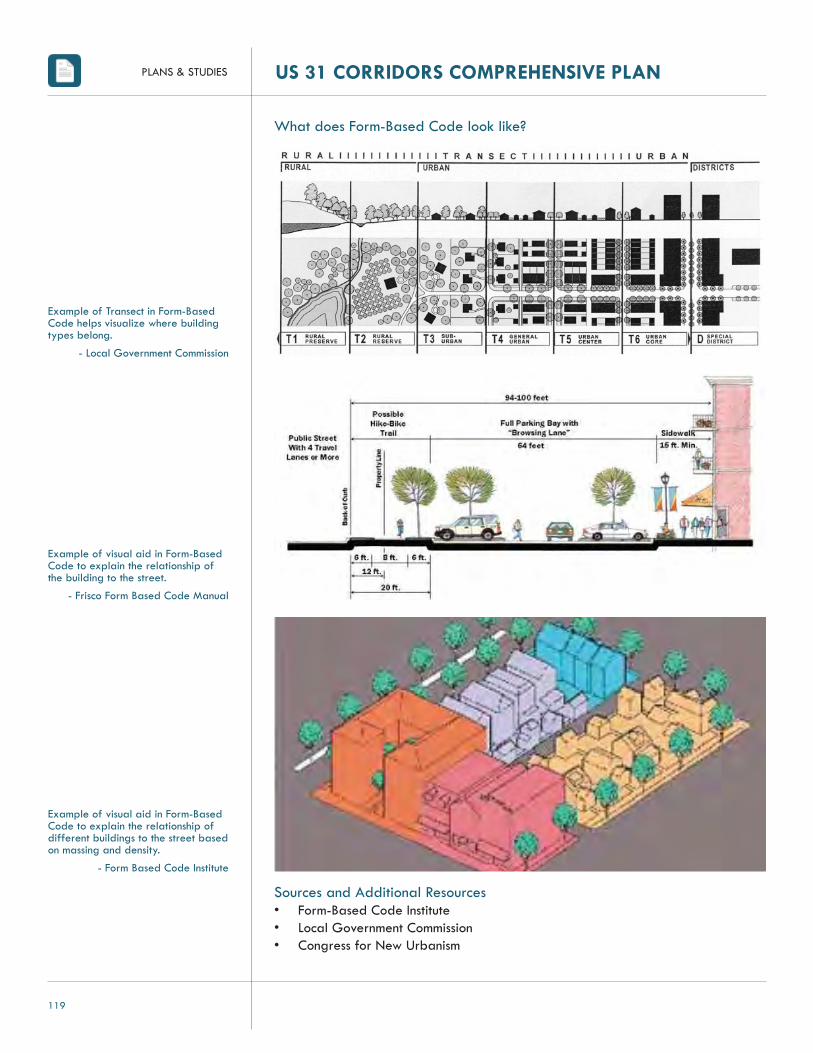
PLANS & STUDIES US 31 CORRIDORS COMPREHENSIVE PLAN
119
What does Form-Based Code look like?
Sources and Additional Resources• Form-Based Code Institute• Local Government Commission• Congress for New Urbanism
Example of Transect in Form-Based Code helps visualize where building types belong.
- Local Government Commission
Example of visual aid in Form-Based Code to explain the relationship of the building to the street.
- Frisco Form Based Code Manual
Example of visual aid in Form-Based Code to explain the relationship of different buildings to the street based on massing and density.
- Form Based Code Institute

PLANS & STUDIES
120
US 31 CORRIDORS COMPREHENSIVE PLAN
MIXED-USE DISTRICT
What is Mixed-Use?A mixed-use development integrates retail and commercial uses, as well as public spaces, with residential development, suburban infi ll sites, and new towns or neighborhoods. Mixed-use developments can take different forms and may include the following: • Neighborhood commercial centers • Smaller town main streets with residences above retail and offi ces• Higher density urban mixed-use town centers• Suburban infi ll sites• Conversion of single-use malls and strip centers to create a town center• New towns or neighborhoods.
Why should we incorporate Mixed-Use?Providing a mix of uses allows opportunities for employment, entertainment and living to be in close proximity to one another which can reduce traffi c be-cause many needs are within walking or bicycling distance.
How can Mixed-use be used in our City?Mixed-use developments can be encouraged and facilitated in communities in several different ways including the following:• Incorporate mixed-use developments in the comprehensive plan • Incorporate or adopt Form-Based codes into or as local zoning ordinance• Designating mixed-use areas in single-use areas• Using zoning and development regulations to enable conversion of large vacant
sites or buildings to mixed-use developments • Add adopting incentives, such as expedited approvals, one-stop permitting, and
density bonuses to encourage mixed-use development
What does Mixed Use look like?
Scale• Project scale fi ts in with surrounding neighborhood• Project scale is economically feasible
Density• Development intensity and housing density support each other • Development density is typically high enough to support transit
Mix of housing and other uses• Development includes a mix of housing options, such as affordable and life-
cycle housing • Development includes/supports businesses that the neighborhood needs
Pedestrian environment• Development has well-connected system of sidewalks • Pedestrian amenities such as benches, shade trees, planters, and pedestrian-
scaled lighting are typically included throughout the development

PLANS & STUDIES US 31 CORRIDORS COMPREHENSIVE PLAN
121
• Buildings typically front the street, providing a pleasant walking environment • Does the street frontage include windows, or is it a blank wall?• Large walls of development have detail to provide more visual interest
Transit access• Transit is typically convenient to residents and workers • Bush shelters and benches are provided where appropriately needed for
residents and workers
Parking• Convenient parking• Shared parking opportunities for uses with peak parking demands at different
times of the day • Parking is located in the rear so it does not negatively affect pedestrian
experience • Parking can be accommodated behind or under proposed buildings
Open space and environment• Open space incorporated into development • Buildings provide convenient access to open space
Sources and Additional Resources• Metropolitan Area Planning Council Smart Growth & Regional Collaboration• Urban Land Institute: Ten Principles for Reinventing America’s Suburban Strips
Example of a mixture of retail area next to residential area
- Washingtonian Center, Fairfax, Virginia
Example of horizontal mixed-use development
- Frisco Form Based Code Manual
Example of vertical mixed-use development
- Frisco Form Based Code Manual
Example of vertical mixed use with commercial on fi rst fl oor and residential above
- Washington Town Center, Robbinsville New Jersey

PLANS & STUDIES
122
US 31 CORRIDORS COMPREHENSIVE PLAN
SHARED ACCESS PARKING
What is Shared-Access Parking?Shared-access parking is when two or more property owners agree to share a single driveway that accesses both or multiple properties and their adjacent parking lots. There are several benefi ts to shared access parking along the corridor, including:• Reducing the number of contact points between vehicles, pedestrians, and
bicyclists • Reducing congestion by maintaining the fl ow of traffi c along the main roadway• Provides more area for landscaping• Makes the bicycle and pedestrian environment safer• Makes access easier and safer, therefore more appealing for customers for
retail stores
Why should we implement Shared-Access Parking?Closely spaced driveways along a roadway create many confl ict points be-tween vehicles, bicyclists, and pedestrians. Consolidating and relocating drive-ways reduces the number of driveways on the main roadway, thus reducing the number of confl ict points at and between driveways, and helps traffi c move smoothly and safer along the main roadway. Confl ict points are areas where the paths of vehicles and pedestrians and/or bicyclists intersect. Another way to improve traffi c fl ow and increase safety along a corridor with multiple en-trances is to create a local access lane, which acts as a path system connecting adjacent parking lots and allowing a primary access point along the major thoroughfare. Connecting adjacent parking lots allows for indirect access to the main roadway and reduces the number of driveways on the main roadway, as well as the number of confl ict points.

PLANS & STUDIES US 31 CORRIDORS COMPREHENSIVE PLAN
123
Example of Shared Access Improvements
- Tucson, Arizona
What does Shared-Access Parking look like?
Example of implementing a Local Access Lane
- Tucson, Arizona
Sources and Additional Resources• City of Tucson's Grant Road Improvement Plan• Victoria Transport Policy Institute• Context Sensitive Solutions.org

PLANS & STUDIES
124
US 31 CORRIDORS COMPREHENSIVE PLAN
SIGN CLUTTER
What is Sign Clutter?The charm and appearance of commercial districts plays an important part in a community’s image. A key contributor of this image is on-premise signs, or signs located on the site of the business that they advertise. Signs say a lot about a place, yet all too often a community's image is blighted by on-premise signs that are too large, too tall, too numerous, or poorly located. The intense number of on-premise signs can create visual clutter that detracts from the unique character of a place; yet, attractive on-premise signs can greatly im-prove the streetscape. Other sign elements related to sign clutter can include:• Blocking of public views or landmarks• Out of scale with surroundings• Blocking other signs• Incompatible with architectural features of surrounding buildings• Overly dominant due to location, shape, color or movement• Inconsistent with the quality of other development How do we fi x sign clutter?Certain regulatory measures can be taken to help reduce clutter along the corridor while achieving a desirable streetscape image. Creating guide-lines within the local sign ordinance that regulate on-premise signs, such as the height, size, type, placement, number and illumination of signs, can help achieve reduced sign clutter and enhance the streetscape appearance. The following are elements that can be incorporated into the local sign ordinance to achieve a more attractive streetscape through sign regulations:• Freestanding signs should be recognized that they are part of the landscape.
The use of low mounting walls, typically referred to as ground signs or monument signs with masonry bases and shrubs, ground cover and seasonal plantings can help integrate these signs with their sites
• When a street canopy exists along the corridor, lower signs are more visible below the canopies of trees
• Incentives can be offered to encourage better design of signs• Buildings that are set closer to the street can rely more on wall signs
Sources and Additional Resources:• APA PAS: Context Sensitive Signage Design• Restructuring the Commercial Strip – USEPA• Conservation Tools• ULI – Ten Principles for Reinventing America’s Suburban Strips

PLANS & STUDIES US 31 CORRIDORS COMPREHENSIVE PLAN
125
Ground sign example in Bellevue, Washington
Photo of San Diego Embarcado before sign clutter was reduced through sign regulations.
Photo of San Diego Embarcado after sign clutter was reduced through sign regulations.

PLANS & STUDIES
126
US 31 CORRIDORS COMPREHENSIVE PLAN
UTILITIESAs part of an overall master plan for several areas near the city of Kokomo, American Structurepoint was asked to determine approximate sizes and routes for sanitary and storm sewers in the planning area. The planning area gener-ally consists of four light industrial areas and one low-density residential area (Areas 1-5) along the US 31 Bypass corridor just east of the city. This sum-mary memo includes a discussion of the analysis and results of pipe sizes and possible routes for both sanitary and storm sewers, as well as cost estimates for each area. It should be noted that this analysis is a high-level analysis of the planning area. A more detailed analysis of each planning area would be required to better determine details, such as localized pump station locations, depth of sewers, fi nal location of sewers, and break points between differ-ence sizes of sewer. For the purposes of the cost estimate analysis, some break points between sewer sizes were assumed. A brief sanitary sewer elevation analysis was also performed to determine which areas would be likely candi-dates for additional lift stations.
SANITARY SEWERSAs part of the sanitary sewer analysis, American Structurepoint examined the City of Kokomo Sanitary Masterplan Report (January 2009) completed by Donohue and Associates and compared land uses and fl ow values for each land use to values typically used by American Structurepoint during sewer mas-terplanning. Donohue assumed the southernmost industrial area and the middle industrial area near Darrough Chapel to be commercial and/or residential. For the purposes of this planning study, both areas were assumed to be light industrial. Also, the Donohue study did not plan for sewers in the northernmost area where the US 31 Bypass connects back with US 31.
The Donohue study calculated fl ows for different land use areas based on existing metered fl ows at the wastewater treatment plant. The values of 200 gpd/ac for low-density residential, 700 gpd/ac for light industrial, and 1300 gpd/ac for heavy industrial are reasonably close to typical values American Structurepoint would use. Since these values were based on wastewater treat-ment plant fl ow, American Structurepoint used these values in our analysis. For Area 1, whose industrial classifi cation (light or heavy) is unknown at this time, an average value of 1000 gpd/ac was used.
When comparing calculated results to the Donohue study, American Structure-point generally concurs with the sewer size estimates given in the Donohue study. The planning areas will require sewers in sizes 8 inch to 18 inch in diam-eter. As development of the planning areas occurs, several existing lift stations may require upgrades including the Apperson Way Pump Station, Darrough Chapel Pump Station, and Center Road Pump Station. In particular, the Ap-person Way Pump Station may require additional upsizing beyond what is

PLANS & STUDIES US 31 CORRIDORS COMPREHENSIVE PLAN
127
stated in the Donohue study given Area 1 does not appear to be included in that study. Where appropriate, the likely outlet for each area is indicated. Of note, the location for the southern sanitary sewer outlet for Area 3 is unclear at this time and is not readily indicated in the Donohue study. Approximate sizes and locations for the proposed sewers are shown in Exhibit 1.
Our analysis also concluded it is likely additional pump stations will be re-quired in Areas 1, 2, 3, and 4. The intent of these stations was assumed to be lifting in nature where the wastewater is simply lifted up in elevation and discharged into an adjacent higher elevation sewer. Therefore, no force mains are shown in Exhibit 1.
It should be noted American Structurepoint performed this analysis on the plan-ning area only and assumed the Donohue study adequately addresses any additional sewer capacity issues between the planning areas and Kokomo’s wastewater treatment plant.
STORM SEWERSKokomo is located within Howard County, which has adopted the release rate standard of 0.3 cfs, the maximum fl ow of stormwater allowed to leave a site. Anything greater than that amount would require on site or regional deten-tion/retention to maintain this maximum allowable fl ow to local waterways. Therefore, development in the planning area will require storage. American Structurepoint’s calculations for the purposes of this study assume a release rate of 0.3 cfs, which would be on the downstream side of any future storage within new development.
For storm sewer sizing purposes, each area was divided into sub-areas based on GIS DEM data to determine approximate watershed boundaries within each area. The fl ow rates for each sub-area were then calculated based on the 0.3 cfs/ac value.
To determine pipe size, the calculated fl ow rates for each sub-area and mini-mum slopes for each pipe size given in the Indiana LTAP Stormwater Drain-age Manual were entered into Manning’s equation. An iterative process fol-lowed to determine pipe sizes based on minimum permissible slopes. Based on these slopes, estimated pipe diameters range from 15 to 84 inches. Diameters could be reduced by increasing pipe slope beyond the minimum permissible slope. Approximate sizes and locations of storm sewers are shown in Exhibit 1. It should be noted storm sewers are intended to represent a worst case scenar-io. American Structurepoint understands fi nding additional outlets for stormwa-ter could substantially reduce the size of storm sewers required and minimize large pipe crossings of the US 31 Bypass. This could therefore minimize costs substantially.

PLANS & STUDIES
128
US 31 CORRIDORS COMPREHENSIVE PLAN
SUITABILITY ANALYSISThe goal of the suitability analysis is to identify areas most suitable for future development. Suitability is important to determine which areas of the com-munity are more attractive to developers or future homeowners. The suitability map was created through CommunityViz software, an extension to GIS. The map helps to visually realize the impact opportunities and constraints can have on the growth and development of the Kokomo community. Suitability was confi gured by identifying the following opportunities and constraints:
• Opportunities: o Schools: Areas in close proximity to schools are popular residential areas
because homebuyers, particularly with kids, desire to be close to schools o Parks and Recreation Facilities: Areas close to parks or recreational facilities
are attractive for residential developments since it provides a recreational opportunities, places to socialize and exercise near residences.
o US 31 Freeway Interchanges: The fi ve interchanges along the US 31 Freeway are desirable locations for commercial and industrial development due to the proximity to high volume traffi c.
o Major Roads: Major arterial roadways are primary corridors in connecting surrounding communities throughout the Kokomo and Howard County area. Businesses and industries are attracted to these areas due to the high volume of traffi c and greater regional connections.
o Airport: The Kokomo Airport is an important transportation amenity for economic development. Close proximity to the airport will be attractive to businesses and industries that rely on air transportation.
o Indianapolis: The Indianapolis metropolitan area just around one hour drive from Kokomo, working, shopping and visiting the metropolitan region. This makes the southern portion of Kokomo and Howard County attractive to businesses, industrial and residential development.
o Existing US 31 Bypass: The existing Bypass is Kokomo’s major commercial shopping destination for the community and surrounding areas, making the corridor attractive for commercial development.
• Constraints o Floodplain: Floodplains areas are better kept with limited development to
help protect sensitive environmental areas. Additionally, these areas are often undesirable locations for commercial, industrial and residential development due to the liability and increased prevention costs of fl ooding.
o Hydric Soil Areas: Hydric soils have poor soil drainage which can pose risks for fl oods and property damage.
o Confi ned Feeding Operations: Residential developments are likely to develop far enough away from Confi ned Feeding Operations to prevent nuisance hazards from impacting residences.
o Railroads: Areas close to railroad tracks are typically undesirable locations for residential development due to noise and safety impacts on the land.

PLANS & STUDIES
128
US 31 CORRIDORS COMPREHENSIVE PLAN
Suitability scores for each parcel were calculated based on the factors listed above. The Suitability Analysis Map identifi es the most suitable parcels for development in green and the least suitable parcels for development in red.
WITH THE NEW US 31 VS. WITHOUT THE NEW US 31 The suitability of the land changes dramatically when comparing the map with-out construction of the new US 31 Freeway versus construction of the freeway. With construction of the US 31 Freeway, land surrounding interchanges greatly increases in suitability for new development since residents and businesses will have more options for access to major corridors. Without construction of the US 31 Freeway, areas closer to the existing US 31 Bypass, particularly the southern part of the corridor, show a signifi cant amount of land more suitable for development due to its close proximity to the corridor and the pull from the Indianapolis metropolitan area.
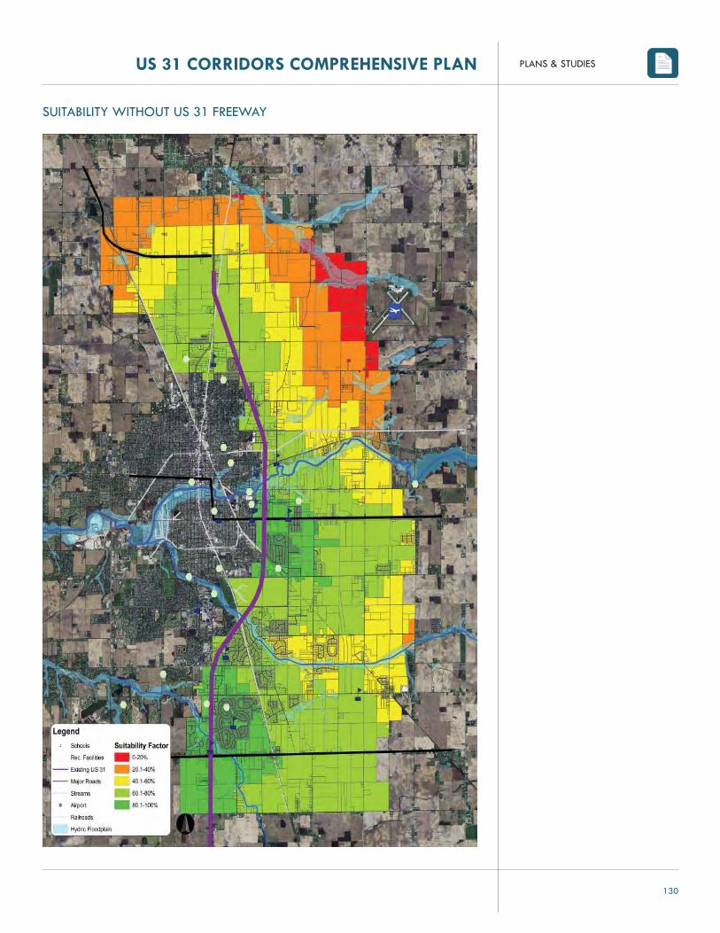
PLANS & STUDIES
130
US 31 CORRIDORS COMPREHENSIVE PLAN
SUITABILITY WITHOUT US 31 FREEWAY

PLANS & STUDIES US 31 CORRIDORS COMPREHENSIVE PLAN
131
SUITABILITY WITH US 31 FREEWAY

PLANNING PROCESS
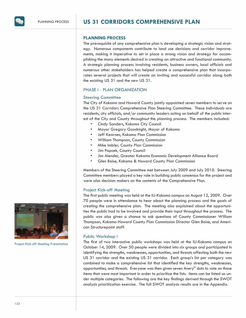
PLANNING PROCESS US 31 CORRIDORS COMPREHENSIVE PLAN
133
PLANNING PROCESSThe prerequisite of any comprehensive plan is developing a strategic vision and strat-egy. Numerous components contribute to land use decisions and corridor improve-ments, making it imperative to set in place a strong vision and strategy for accom-plishing the many elements desired in creating an attractive and functional community. A strategic planning process involving residents, business owners, local offi cials and numerous other stakeholders has helped create a comprehensive plan that incorpo-rates several projects that will create an inviting and successful corridor along both the existing US 31 and the new US 31.
PHASE I - PLAN ORGANIZATION
Steering CommitteeThe City of Kokomo and Howard County jointly appointed seven members to serve on the US 31 Corridors Comprehensive Plan Steering Committee. These individuals are residents, city offi cials, and/or community leaders acting on behalf of the public inter-est of the City and County throughout the planning process. The members included:
• Cindy Sanders, Kokomo City Council• Mayor Gregory Goodnight, Mayor of Kokomo• Jeff Kearnes, Kokomo Plan Commission• William Thompson, County Commission• Mike Imbler, County Plan Commission• Jim Papcek, County Council• Jim Alender, Greater Kokomo Economic Development Alliance Board• Glen Boise, Kokomo & Howard County Plan Commission
Members of the Steering Committee met between July 2009 and July 2010. Steering Committee members played a key role in building public consensus for the project and were also decision makers on the contents of the Comprehensive Plan.
Project Kick-off MeetingThe fi rst public meeting was held at the IU-Kokomo campus on August 12, 2009. Over 70 people were in attendance to hear about the planning process and the goals of creating the comprehensive plan. The meeting also explained about the opportuni-ties the public had to be involved and provide their input throughout the process. The public was also given a chance to ask questions of County Commissioner William Thompson, Kokomo-Howard County Plan Commission Director Glen Boise, and Ameri-can Structurepoint staff.
Public Workshop IThe fi rst of two interactive public workshops was held at the IU-Kokomo campus on October 14, 2009. Over 50 people were divided into six groups and participated in identifying the strengths, weaknesses, opportunities, and threats affecting both the new US 31 corridor and the existing US 31 corridor. Each group’s list per category was combined to make a comprehensive list that identifi ed the key strengths, weaknesses, opportunities, and threats. Everyone was then given seven Avery® dots to vote on those items that were most important in order to prioritize the lists. Items can be listed as un-der multiple categories. The following are the key fi ndings derived through the SWOT analysis prioritization exercise. The full SWOT analysis results are in the Appendix.
Project Kick-off Meeting Presentation

PLANNING PROCESS
134
US 31 CORRIDORS COMPREHENSIVE PLAN
StrengthsStrengths are those elements of the corridors that defi ne its greatness. These are elements that must be preserved and protected throughout the planning process. The following are the top strengths identifi ed in the SWOT exercise.
• Land availability along the new US 31 corridor for manufacturing development and expansion
• Limited access on and off the new US 31 Freeway• Kokomo’s proximity to universities and higher education• Kokomo’s availability of a strong workforce
WeaknessesWeaknesses are issues or problems within the community that can be changed, cor-rected, or turned into strengths through local control or infl uence. The following are the major weaknesses identifi ed in the SWOT exercise.
• Lack of public/multiple modes of transportation available• Visitors and travelers bypassing Kokomo community with new US 31• Lack of unifi ed vision for community between the City and County• New businesses or relocation of existing businesses along the new US 31
corridor• Numerous stoplights and access points currently along existing US 31• Lack of aesthetically pleasing and consistent architectural character and
landscaping design/guidelines
OpportunitiesOpportunities are those elements of the community that may not necessarily be strengths, but could potentially be built upon. An opportunity is a positive that hasn’t yet been realized. The following are the top opportunities identifi ed in the SWOT exercise.
• Ability to plan and control zoning along new US 31 corridor for appropriate growth
• New development along the new US 31 corridor• Restriction of development along new US 31 corridor• Improve aesthetics and architectural standards along the existing US 31
corridor• Increase the sense of place and identity of the Kokomo community and the
US 31 corridors by capitalizing on the community’s history• Create a gateway and wayfi nding system throughout the Kokomo
community connecting to the downtown
ThreatsThreats are those issues or problems felt by the community that have not yet hap-pened and are not necessarily within local control. At the time of the SWOT analysis, the following threats were the most predominant within the Kokomo community.
• Further decline of the existing US 31 with future impacts from lack of traffi c, lack of maintenance, business relocation and business vacancies
• Travelers bypassing Kokomo• Too many development regulations and/or moratoriums
Public Workshop I - Small group discussions
Public Workshop I - Small group brainstorming session
Public Workshop I - Consensus build-ing exercise

PLANNING PROCESS US 31 CORRIDORS COMPREHENSIVE PLAN
135
Public Workshop IIThe second public workshop was held on at the IU-Kokomo campus on November 19, 2009. Over 50 people attended the interactive workshop to help develop a common vision of what the future corridors would look like. Attendees worked in small groups to build off the results of the fi rst public workshop results to develop a vision of the how the new and existing corridors will be 20 years from now. Each group presented the elements that needed to be included in the vision. Once a consensus was reached, participants came up with strategies, programs and policies necessary to achieve the vision. The following are the initial goals derived from the input gathered during the second public workshop that helped form the goals and objectives found within the plan.
Wayfi nding/Gateways• Create gateways along US 31 through landscaping and architectural features
to help attract travelers to Kokomo • Establish gateways along existing US 31 to emphasize shopping, historic,
government, park, and downtown districts • Create visitor centers where the existing US 31 and the new US 31 split from
one another
Urban Design/Alternative Transportation• Enhance the streetscape throughout the existing US 31 corridor by removing
guardrails and replace with trees and landscaping to create a more aesthetically pleasing corridor
• Create a pedestrian-friendly atmosphere along the existing US 31 that is safe and can accommodate multiple uses, such as walking, biking, etc.
• Create transportation mechanisms to reduce traffi c congestion, like initiating the complete street concept
• Allow and expand upon opportunities for public transportation and multi-modal transportation
Outdoor Recreation/Environmental• Create additional outdoor recreational opportunities and networks to connect
amenities (Wildcat Creek, Nickel Plate Trail, Walk of Excellence, Kokomo Reservoir)
• Emphasize Wildcat Creek’s outdoor amenities and recreational opportunities between downtown Kokomo and Greentown
• Protect and preserve watersheds and Wildcat Creek
Zoning/Land Use• Prevent future blight and incompatible land uses • Create zoning classifi cations along the new US 31 to accommodate
manufacturing and distribution centers and restrict retail uses • Allow heavier industrial uses in the northern area of the new US 31 corridor
to utilize close proximity to the airport. • Create zoning along the new US 31 that would allow for medical, offi ce,
business parks, educational institutions, and light industrial uses to be clustered together
Public Meeting II: Small group vision-ing exercise

PLANNING PROCESS
136
US 31 CORRIDORS COMPREHENSIVE PLAN
• Allow for destination type uses or structures between the existing and new US 31 corridors’ that are slightly visible along the new US 31 to help attract visitors
• Allow access roads to provide safe and effi cient access to uses along the new and existing US 31 to help improve traffi c fl ow and congestion and reduce the number of stoplights
• Redevelop existing buildings that are obsolete or vacant along existing US 31
• Create architectural standards and a review process for new and redeveloped buildings along existing US 31
• Restrict development from occurring east of new US 31 • Restrict billboards along new US 31 • Allow for a limited amount of attractive retail uses or a mixture of uses along
Markland Avenue and East Boulevard between existing US 31 and new US 31 interchanges
• Require new developments to have more green space • Continue residential character in areas between new and existing US 31,
south of East Boulevard • Preserve agricultural land uses and character along new US 31 between
Markland Avenue intersection and Touby Pike intersection
Economic Development• Attract and retain career-oriented professionals/jobs • Create opportunities to attract economic growth and embrace this growth • Diversify industrial hubs while maintaining automotive and technical heritage
PHASE II - ANALYSIS REVIEW AND PROFILEReview of Past Plans and StudiesThe following past plans and studies were reviewed to understand relevant issues regarding the areas of the new and existing US 31 corridors. Review of the compre-hensive plans and development ordinances have also helped identify needed amend-ments or future impacts on the study areas based on the results of the Corridor Plan.
• 2004 Howard County Comprehensive Plan• 2002 Howard County Ordinance for Flood Hazard Areas, as amended• 2007 Howard County Subdivision Control Ordinance• 1981 Howard County Zoning Ordinance, as amended• 2009 Howard County Zoning Ordinance• 2001 City of Kokomo Comprehensive Plan• 2008 City of Kokomo Flood Hazard Areas Ordinance• 2006 City of Kokomo Subdivision Control Ordinance• 2003 City of Kokomo Zoning Ordinance• 2006 Howard County Multi-Hazard Mitigation Plan• 2008 Draft City of Kokomo Sanitary Master Plan Improvements Report• 2008-2011 Transportation Improvement Program for Kokomo and Howard
County• 2009 The Long Range Transportation Plan 2010-2035

PLANNING PROCESS US 31 CORRIDORS COMPREHENSIVE PLAN
137
Site AnalysisA site analysis was conducted along the existing and new corridor to better under-stand the historic, contextual, and environmental issues. Existing utility, parcel, and land-use information and traffi c counts were also gathered to give further analysis of the corridor as well as to help identify under utilized parcels on the existing US 31 corridor. Overall, the analysis outlined existing conditions within the corridors that were deemed signifi cant to incorporate or rehabilitate and issues within the corridors that needed to be addressed in order to improve the value, aesthetics, and character of the area.
PHASE III - LAND USE PLANNINGLand use planning within this phase was conducted in conjunction with Phase IV – Trans-portation Planning due to the intrinsic connection between the two.
Development Suitability AnalysisDevelopment suitability scenarios were created using GIS extension software, Com-munityViz. The software helped identify development suitability based on various indicators proximity to the metropolitan area, airports, confi ned feeding operations, creeks, fl oodplains, major roads, hydric soils, recreational facilities, schools, trails, and existing development. The suitability analysis generated by this information was used as a tool throughout the planning process to make appropriate future land use recom-mendations.
PHASE IV - TRANSPORTATION PLANNINGTransportation EvaluationRight-of-way along the existing US 31 corridor was evaluated in order to deter-mine the best possible recommendations for safer and more effi cient vehicular and pedestrian access throughout the corridor and connecting to the greater Ko-komo community. Access management recommendations set forth in this plan were developed from input and discussion from the public meetings, steering commit-tee meetings, and stakeholders. Future transportation and traffi c impacts result-ing from the new US 31 were also analyzed and identifi ed in recommending up-dates in the various transportation plans throughout the city, county, and MPO in order to appropriately plan for increased traffi c volumes from the new US 31.
PHASE V - DEVELOPMENT REGULATIONS RECOMMENDATIONSDevelopment RegulationsBased on the analysis, studies, public input and stakeholder coordination conducted, development recommendations were made to account for potential changes neces-sary to help guide the preferred development the community indicated they wanted to see.

APPENDIX

APPENDIXUS 31 CORRIDORS COMPREHENSIVE PLAN
139US 31 CORRIDORS PROJECT AREA
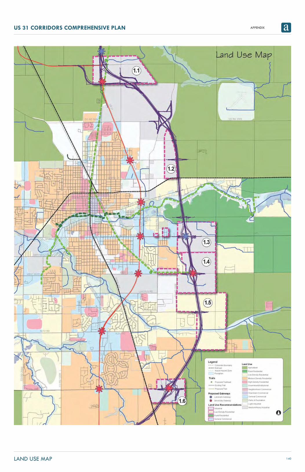
APPENDIXUS 31 CORRIDORS COMPREHENSIVE PLAN
140LAND USE MAP

APPENDIXUS 31 CORRIDORS COMPREHENSIVE PLAN
141US 31 FREEWAY OVERLAY ZONE

APPENDIXUS 31 CORRIDORS COMPREHENSIVE PLAN
142EXISTING US 31 BYPASS OVERLAY ZONE
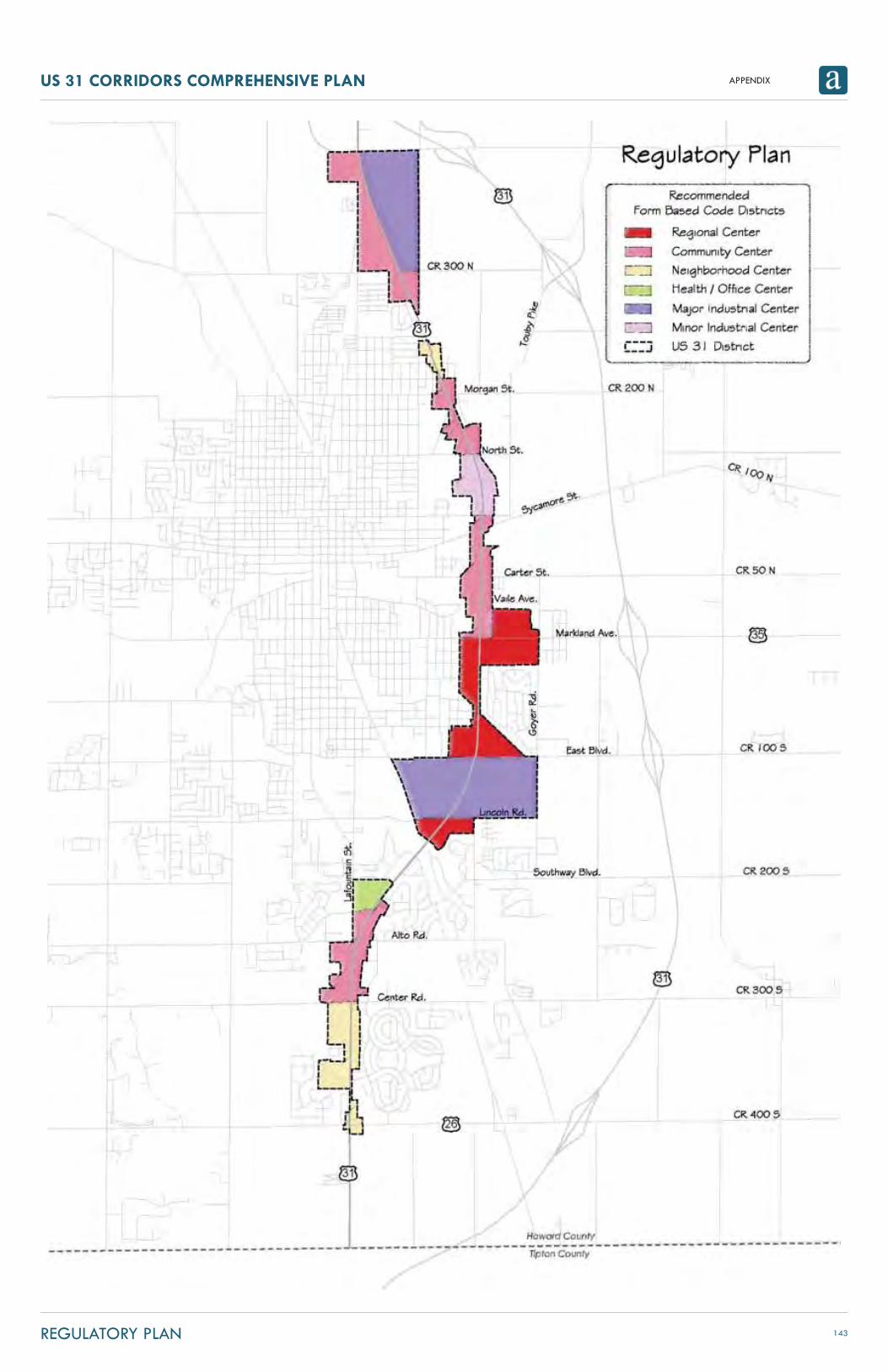
APPENDIXUS 31 CORRIDORS COMPREHENSIVE PLAN
143REGULATORY PLAN

APPENDIXUS 31 CORRIDORS COMPREHENSIVE PLAN
144PROPOSED REDEVELOPMENT AREAS

APPENDIXUS 31 CORRIDORS COMPREHENSIVE PLAN
145THOROUGHFARE PLAN UPDATES

APPENDIXUS 31 CORRIDORS COMPREHENSIVE PLAN
146TRANSPORTATION PLAN

APPENDIXUS 31 CORRIDORS COMPREHENSIVE PLAN
147UTILITY IMPROVEMENT RECOMMENDATIONS