3.0 PROJECT DESCRIPTIONcontent.gov.mb.ca/.../pdf/project_p7a/chapters/chapter3.pdfLittle Grand...
51
Environmental Assessment Report for the Proposed All Season Road Linking Pauingassi First Nation and Little Grand Rapids First Nation to the Little Grand Rapids Airport (Project P7a) 3-1 3.0 PROJECT DESCRIPTION This chapter of the environmental assessment report provides a description of the proposed P7a All-Season Road Project. The project description includes its regional context, location on the east side of Lake Winnipeg, ownership of the land, alternatives means of carrying out the project, construction stages, project components and activities, construction materials, waste products, workforce, schedule and funding. Information on the proposed P7a All-Season Road Project is described to facilitate the identification and analysis of potential environmental effects, and the identification of measures to mitigate adverse effects in subsequent chapters. 3.1 Project Background In late 2008, the Government of Manitoba announced its intention to conduct a strategic initiative to provide improved, safer and more reliable transportation services to connect the remote communities on the east side of Lake Winnipeg with the rest of the province. The Manitoba East Side Road Authority (ESRA) was established as provincial Crown Agency and has been given the mandate to manage the East Side Transportation Initiative with the intent of increasing transportation opportunities for communities on the east side of Lake Winnipeg (Figure 3-1). Currently, these communities rely primarily on winter and seasonal roads, air or ferry service to transport people and goods. ESRA’s mandate includes planning, design and construction of all-season roads to improve the connectivity of First Nations and other northern communities on the east side of Lake Winnipeg to the provincial highway system. In the interim, ESRA continues to assess the feasibility of winter road enhancements to the network on the east side of Lake Winnipeg and remove major ice crossing components to increase safety factors and provide lengthened winter road service. ESRA is proposing to construct an all-season road that will connect Little Grand Rapids First Nation and Pauingassi First Nation to the Little Grand Rapids Airport (Figure 3-2). The proposed all-season road consists of approximately 38.1 km of road on provincial Crown land, which is the subject of this project description, and about 3.4 km of Community Access Roads on Pauingassi and Little Grand Rapids First Nation Reserve lands. The Community Access Roads fall under Aboriginal Affairs and Northern Development Canada’s jurisdiction. The purpose of the P7a All-Season Road Project is to provide expedited year-round vehicular access, connecting Little Grand Rapids First Nation and Pauingassi First Nation to the Little Grand Rapids Airport.
Transcript of 3.0 PROJECT DESCRIPTIONcontent.gov.mb.ca/.../pdf/project_p7a/chapters/chapter3.pdfLittle Grand...

Environmental Assessment Report for the Proposed All Season Road Linking Pauingassi First Nation and Little Grand Rapids First Nation to the Little Grand Rapids Airport (Project P7a) 3-1
3.0 PROJECT DESCRIPTION
This chapter of the environmental assessment report provides a description of the proposed
P7a All-Season Road Project. The project description includes its regional context, location on
the east side of Lake Winnipeg, ownership of the land, alternatives means of carrying out the
project, construction stages, project components and activities, construction materials, waste
products, workforce, schedule and funding. Information on the proposed P7a All-Season Road
Project is described to facilitate the identification and analysis of potential environmental effects,
and the identification of measures to mitigate adverse effects in subsequent chapters.
3.1 Project Background
In late 2008, the Government of Manitoba announced its intention to conduct a strategic
initiative to provide improved, safer and more reliable transportation services to connect the
remote communities on the east side of Lake Winnipeg with the rest of the province. The
Manitoba East Side Road Authority (ESRA) was established as provincial Crown Agency and
has been given the mandate to manage the East Side Transportation Initiative with the intent of
increasing transportation opportunities for communities on the east side of Lake Winnipeg
(Figure 3-1). Currently, these communities rely primarily on winter and seasonal roads, air or
ferry service to transport people and goods. ESRA’s mandate includes planning, design and
construction of all-season roads to improve the connectivity of First Nations and other northern
communities on the east side of Lake Winnipeg to the provincial highway system. In the interim,
ESRA continues to assess the feasibility of winter road enhancements to the network on the
east side of Lake Winnipeg and remove major ice crossing components to increase safety
factors and provide lengthened winter road service.
ESRA is proposing to construct an all-season road that will connect Little Grand Rapids First
Nation and Pauingassi First Nation to the Little Grand Rapids Airport (Figure 3-2). The proposed
all-season road consists of approximately 38.1 km of road on provincial Crown land, which is
the subject of this project description, and about 3.4 km of Community Access Roads on
Pauingassi and Little Grand Rapids First Nation Reserve lands. The Community Access Roads
fall under Aboriginal Affairs and Northern Development Canada’s jurisdiction. The purpose of
the P7a All-Season Road Project is to provide expedited year-round vehicular access,
connecting Little Grand Rapids First Nation and Pauingassi First Nation to the Little Grand
Rapids Airport.

Environmental Assessment Report for the Proposed All Season Road Linking Pauingassi First Nation and Little Grand Rapids First Nation to the Little Grand Rapids Airport (Project P7a) 3-2
Figure 3 - 1 Pauingassi and Little Grand Rapids First Nations Showing Existing Winter Roads

Environmental Assessment Report for the Proposed All Season Road Linking Pauingassi First Nation and Little Grand Rapids First Nation to the Little Grand Rapids Airport (Project P7a) 3-3
Figure 3 - 2 Proposed All Season Road Connecting Pauingassi and Little Grand Rapids First Nation to the Little Grand Rapids Airport

Environmental Assessment Report for the Proposed All Season Road Linking Pauingassi First Nation and Little Grand Rapids First Nation to the Little Grand Rapids Airport (Project P7a) 3-4
3.2 Project Proponent
The proponent of the P7a All-Season Road Project is ESRA.
3.3 Project Location
The proposed P7a All-Season Road Project will extend south approximately 36.4 km from
Pauingassi First Nation to Little Grand Rapids First Nation and connect both First Nations to the
Little Grand Rapids Airport area via two east-west all-season access spurs of approximately 1.2
km (southern access) and 540 m (northern access) in length (Figure 3-2). Community Access
Roads on First Nation Reserve lands will connect the All-Season Road to the communities of
Pauingassi and Little Grand Rapids. The Community Access Road on Pauingassi Reserve land
will be 1.2 km and the Community Access Road on Little Grand Rapids Reserve land will be 2.2
km.
The total distance of new road is 41.5 km and travels along the east side of Family Lake and the
west side of Fishing Lake. The proposed P7a All-Season Road Project will cross two major
watercourses requiring bridges; one across an unnamed watercourse between Family and
Fishing lakes and the other across Root Creek on the east end of Family Lake.There are also
six minor watercourses requiring culverts, and a number of low lying areas requiring
equalization culverts. The province of Ontario is located about 16 km to the east of Pauingassi
First Nation and about 14 km east of Little Grand Rapids First Nation.
3.4 Land Ownership
The proposed P7a All-Season Road Project will be constructed on provincial Crown land. The
P7a All-Season Road will be owned by the province of Manitoba and will be operated as part of
the provincial all-season road network. Community Access Roads will be located on Pauingassi
and Little Grand Rapids First Nation reserve lands and access roads will be owned by the
respective Pauingassi and Little Grand Rapids First Nations.
3.5 Land Use
Land use in the area of the proposed P7a All-Season Road Project consists mainly of traditional
activities by Pauingassi and Little Grand Rapids First Nations including hunting, trapping, fishing
and berry-picking. A winter road winds west from the communities of Pauingassi and Little
Grand Rapids to Bloodvein First Nation. Another all-season road (Project 1), currently under
construction, will extend north from Provincial Road 304 to Berens River First Nation. The
proposed P7a All-Season Road will replace the existing winter road segment connecting the two
communities of Pauingassi and Little Grand Rapids First Nations to the airport and winter road
network (Figure 3-2).
3.5.1 Pauingassi First Nation
Pauingassi First Nation’s land use plan for the Manitoba Planning Area was developed with the
Government of Manitoba (Pauingassi First Nation and Government of Manitoba 2012). The

Environmental Assessment Report for the Proposed All Season Road Linking Pauingassi First Nation and Little Grand Rapids First Nation to the Little Grand Rapids Airport (Project P7a) 3-5
Pauingassi-Manitoba planning area is designated as three zones: 1) Enhanced Management
Area; 2) Protected Area; and 3) Commercial Area (Figure 3-3).
Figure 3 - 3 Pauingassi First Nation Traditional Use Planning Area
3.5.1.1 Enhanced Management Area
The primary intent for the 25,845 ha Enhanced Management Area is careful management with
an emphasis on ensuring continuation of traditional activities. Pauingassi First Nation intends to
practice and protect their traditional activities in this area unless conservation measures are
warranted and consultation has taken place with Pauingassi First Nation. The maintenance and
construction of community hunting and trapping cabins, continuation of trapping, collection of
non-timber forest products, wild rice harvesting and recreational activities continue to be
supported in this area. Special historical and cultural sites are identified. Economic development
is managed to reduce and mitigate damage to traplines, hunting areas, habitat, special sites,
waterways, waterbodies and the environment. A development plan for resource-based tourism
may be prepared in the future with consideration for the management of endangered or
threatened species and other wildlife and habitat, as well as for the protection of cultural values.

Environmental Assessment Report for the Proposed All Season Road Linking Pauingassi First Nation and Little Grand Rapids First Nation to the Little Grand Rapids Airport (Project P7a) 3-6
This area supports the continuation of the existing winter road and a future all-season road
access. The plan states that all sites associated with the construction of the all-season road be
decommissioned and reclaimed once the road is built and operating. An exception would be
quarry sites required for the maintenance of the all-season road in the future. This area may
include a proposed airport and/or an all-season road between Pauingassi and Little Grand
Rapids First Nations. Extra management precautions are to be taken to protect habitat and
waterways to reduce adverse effects. Commercial forestry, mineral exploration and mining, peat
extraction, exploration or development of petroleum resources, and commercial hydroelectric
generation would be prohibited in the Enhanced Management Area. Customary and traditional
uses are respected and shall continue.
3.5.1.2 Protected Area
The intent for this 272,450 ha Protected Area is the careful management of traditional lands with
an emphasis on ensuring continuation of traditional activities. The area is managed to maintain
and enhance traditional uses and to protect natural and cultural values. Commercial forestry,
mineral exploration or mining including aggregates, exploration or development of petroleum
resources, hydroelectric transmission and generation, wind power installations, peat extraction,
and other large-scale industrial and commercial developments are prohibited in this area.
Wherever possible, roads will be restricted from the Protected Area.
3.5.1.3 Commercial Area
Economic development in the 15,390 ha Commercial Area is managed to reduce and mitigate
damage to traplines, hunting areas, habitat, special sites, waterways, water bodies and the
environment. Land, water and habitat protection objectives such as a 50 m buffer from the
Ordinary High Water Mark around waterways in this land use area are promoted. The
continuation of traditional uses and existing tourism within this area is supported. Mining and
mineral exploration, including metal mining, would be allowed within this area.
3.5.2 Little Grand Rapids First Nation
Little Grand Rapids First Nation’s lands management plan was developed with the Government
of Manitoba (Little Grand Rapids First Nation and Government of Manitoba 2012). The lands
management plan identified six protected areas: 1) Enhanced Management Area; 2)
Commercial Area; 3) Protected Area; 4) Mishipawitigong Cultural Waterway Protected Area; 5)
Pigeon River; and 6) Atikaki Provincial Park portion (Figure 3-4).

Environmental Assessment Report for the Proposed All Season Road Linking Pauingassi First Nation and Little Grand Rapids First Nation to the Little Grand Rapids Airport (Project P7a) 3-7
Figure 3 - 4 Little Grand Rapids First Nation Traditional Use Planning Area
3.5.2.1 Enhanced Management Area
Traditional activities will continue within the Enhanced Management Area unless conservation
measures are warranted and consultation has taken place with Little Grand Rapids First Nation.
Mineral exploration and mining (including peat) is not permitted in this area. Mining activity, such
as aggregate extraction required for road maintenance or construction, will be managed to
protect wildlife, habitats and cultural values. The existing transmission line and winter road
corridor pass through the Enhanced Management Area and will be maintained over time which
includes upgrading the distribution lines.
Planning for an all-season road is underway and the corridor is planned through the Enhanced
Management Area. Aggregate extraction will be allowed for the purpose of all-season road
construction. Quarry sites that are needed for maintenance of the road will remain. If new or
additional utility lines for telecommunications are needed they would be permitted preferably in
the same corridor as the all-season road. Large scale commercial forestry is prohibited;
however, community-based sustainable forestry may be permitted in this area.

Environmental Assessment Report for the Proposed All Season Road Linking Pauingassi First Nation and Little Grand Rapids First Nation to the Little Grand Rapids Airport (Project P7a) 3-8
3.5.2.2 Protected Area
The Protected Area is to be managed to allow and maintain traditional uses, protect cultural and
natural lands and natural resources. The maintenance and construction of community hunting
and trapping cabins, continuation of commercial trapping, collection of non-timber forest
products, wild rice harvesting and recreational activities continue within this area. The area
ensures that habitats, wildlife, waterways and cultural values are protected. Commercial
forestry, mineral exploration and mining, aggregate and peat extraction, exploration or
development of petroleum resources, hydroelectric generation and transmission activities would
be prohibited in the area. Whenever possible, roads will also be prohibited in the Protected
Area. Little Grand Rapids will provide direction to manage float-plane landing areas in the future
within the Protected Area to protect natural and cultural values.
3.5.2.3 Commercial Area
Traditional activities will continue within the Commercial Area unless conservation measures are
required and consultation has taken place with Little Grand Rapids First Nation. Mining
exploration may be allowed within this area and any mining activity will be managed to protect
natural and cultural values. The existing transmission line passes through this area and all
required maintenance and upgrading activities will be permitted. Roads may be permitted in this
area and existing corridor maintenance or new corridors will be planned to minimize the effects
on natural and cultural values. Extra management precautions may be taken to protect habitat
and waterways to reduce effects on all cultural values including traplines, hunting areas, cabins
and special places, as well as natural values such as critical woodland caribou habitat and
waterways protection.
3.5.2.4 Mishipawitigong Cultural Waterway Protected Area
The Little Grand Rapids Mishipawitigong Cultural Waterway Protected Area was created to
provide added protection to the Berens River where it traverses the Commercial Area. The
Berens River is an important cultural waterway to the people of Little Grand Rapids First Nation.
A 150 m buffer has been placed on each side of the waterway to protect the socio-economic,
cultural, ecological and recreational values of this river. Road and utility corridor, and/or the
development of other infrastructure, will be permitted only as necessary to serve the needs of
the community of Little Grand Rapids and/or adjacent land use developments.
3.5.2.5 Pigeon River Protected Area
The land use intent for this area is the same as for the Protected Area. All customary and
traditional uses are respected and will be maintained or enhanced. Construction of the all-
season road and the winter road may be permitted within the Pigeon River Protected Area. This
includes activities required to develop and maintain the roads. Extra care will be taken to protect
the surrounding areas during construction, maintenance and in marshalling and staging areas.
Any proposed all-season road crossing of the Pigeon River Protected Area will be carefully
Environmental Assessment Report for the Proposed All Season Road Linking Pauingassi First Nation and Little Grand Rapids First Nation to the Little Grand Rapids Airport (Project P7a) 3-9
studied and reviewed with Little Grand Rapids First Nation and the Government of Manitoba
before construction begins.
3.5.2.6 Little Grand Rapids Planning Area Portion of Atikaki Provincial Park
Atikaki Provincial Park is located directly south of the Little Grand Rapids First Nation. The
community and Manitoba Conservation and Water Stewardship work together on a plan for
management of the Park. The intent is that the Little Grand Rapids Protected Areas and Atikaki
Provincial Park will provide complimentary direction for the protection and management of
natural and cultural values.
3.6 Project Alternatives
3.6.1 Background
In 1999, Manitoba Transportation and Government Services (now Manitoba Infrastructure and
Transportation – MIT) retained Dillon Consulting Limited to undertake a study to look at the
feasibility of developing an all-season road system to improve access to remote communities on
the east side of Lake Winnipeg. The study was to be a preliminary, cost-benefit assessment to
determine if more comprehensive considerations of an all-season road development in the
study area were justified.
In the report, prepared by Dillon Consulting entitled East Side of Lake Winnipeg All Weather
Road Justification and Scoping Study (2000), two all weather road route scenarios, with
different points of origin, were evaluated. In one scenario, all east side communities would be
connected from the south via Manigotagan. In the other, the northern communities would be
connected from the west via Norway House/Cross Lake with a separate connection from
Manigotagan serving only the southern communities. The report's general conclusion was that
an all-season road in the east side of Lake Winnipeg using either route scenario could be
justified for many communities on the basis of long-term transportation cost savings and other
benefits.
In 2001, Dillon Consulting prepared a second report for Manitoba Transportation and
Government Services entitled Work Plan to Develop an All-Weather Road Network for the East
Side of Lake Winnipeg – Final Report (Dillon Consulting Limited and N.D. Lea 2001). It
presented a planning approach and overall work plan to design and service east side of Lake
Winnipeg communities with an all-season road network.
“Promises to Keep...” Towards a Broad Area Plan for the East Side of Lake Winnipeg (East
Side Planning Initiative 2004) reported on the development of a Broad Area Plan for the east
side of Lake Winnipeg. The East Side Planning Initiative arose out of the Consultation on
Sustainable Development Implementation (COSDI), a multi stakeholder consultation initiative “to
consider and make recommendations to government on how Manitoba can best implement
Sustainable Development Principles and Guidelines into decision-making, including
environmental management, licensing, land use planning, and regulatory processes” that was

Environmental Assessment Report for the Proposed All Season Road Linking Pauingassi First Nation and Little Grand Rapids First Nation to the Little Grand Rapids Airport (Project P7a) 3-10
undertaken between the fall of 1997 and the spring of 1999. The East Side Planning Initiative
was the first large-area planning exercise since the adoption of the COSDI report.
The East Side Planning Initiative report presented a number of transportation-related
recommendations. One key recommendation was that Manitoba Transportation conduct a
thorough review of all-season road routes in collaboration with directly affected First Nation
residents on the east side of Lake Winnipeg and the Métis. The report also advised that the final
route selection should follow from results of an environmental assessment, and Manitoba
Transportation should undertake an amended Regional Transportation Network Study to
consider other means of access, such as rail, bridges, dirigibles, hovercraft and ferries, to
communities on the east side of Lake Winnipeg in addition to an all-season road option.
In 2008, SNC-Lavalin Inc. was commissioned by the Manitoba East Side Road Authority to
conduct a Large Area Transportation Network Study on the east side of Lake Winnipeg. This
study combined the multi-disciplinary planning and engineering work required to identify the
preferred All-Season Transportation Network to connect the East Side communities to the rest
of the all season-road transportation network in Manitoba. At the outset of the study, a number
of alternative surface/air transportation modes, in addition to an all-season road system, were
considered to service the remote communities on the east side of Lake Winnipeg. Generally the
alternative modes considered were not deemed appropriate as a permanent solution on the
grounds of cost, unreliability, environmental damage, safety impairment, or lack of freedom to
move. Table 3-1 summarizes the alternative modes considered, along with some of their key
characteristics.
As a result of the above considerations, it was concluded that the most worthwhile, reliable, safe
and equitable improvement to the existing east side Lake Winnipeg transportation system would
be the construction of an all-season road system, supplemented during its development with,
where appropriate, improved winter roads and permanent bridges. The rationale for this being,
compared with either the existing system, or alternative modes such as rail, hovercraft or
airships/dirigibles:
Greater long-term reliability for safely moving people and goods during all seasons and
most weather conditions;
Greater freedom for people and goods from all east side communities, individuals and
businesses to move; and
More equitable system for travel and trade, on par with the existing all-season road
system serving most communities in province.

Environmental Assessment Report for the Proposed All Season Road Linking Pauingassi First Nation and Little Grand Rapids First Nation to the Little Grand Rapids Airport (Project P7a) 3-11
Table 3 - 1 Alternative Surface and Air Transportation Modes
Mode Characteristics
Railway • Construction cost on a per km basis comparable to that of an all-season road.
• Lengthy connections needed to connect to existing railhead/rail line at Pine
Falls and Wabowden, respectively, duplicate existing provincial roads (70 km of
PR 304 and 131 km of PR 373).
• Much flatter gradients required for rail versus road increases cost; may also be
more difficult to maintain rideable profile over muskeg and permafrost pockets.
• During construction phase difficult to offload/reload goods and people at
continually advancing rail/winter road interface.
• Less freedom to move than with a road system.
Hovercraft • Suitable over large bodies of open water.
• Would likely suffer skirt degradation over muskeg and swamp.
• Potential damage of fragile environment over potential multiple routes.
• May damage ice surface during freeze up, potentially breaking ice and creating
hazards for snowmobilers.
Airships/Dirigibles • Would need to be very large to haul TAC maximum highway loadings (Boeing
Sky Hook HLV maximum pay load 40 tons).
• More sensitive than fixed wing aircraft to inclement weather, potentially a
significant factor east of Lake Winnipeg (Boeing HLV can only operate in winds
up to 25 knots).
Ferries • May be appropriate for summer transportation across lakes or rivers as an
interim lower cost link in an all-season road system.
• An ice bridge parallel to the ferry route could be used for winter transportation
but has potential break through, with safety and environmental degradation
risks.
• Ferries may, where traffic volumes are relatively small and the cost of a bridge
is high, be considered on a more permanent link.
Improved Winter
Roads • Shift existing winter road onto firmer ground along a future all-season road
route.
• Provide permanent bridges at major water crossings along future all-season
road route.
• Could be initial phases in development of an all-season road route.
The East Side Large Area Transportation Network Study identified potential transportation
infrastructure improvements that will provide year-round access to the communities on the east
side of Lake Winnipeg. The final report of the Large Area Transportation Network Study was
completed in 2010 and recommended an all-season road network for the region that is
estimated at approximately 1,028 km in length and would cost approximately $3 billion (2011$)
(SNC-Lavalin, J.D. Mollard, AECOM 2010).

Environmental Assessment Report for the Proposed All Season Road Linking Pauingassi First Nation and Little Grand Rapids First Nation to the Little Grand Rapids Airport (Project P7a) 3-12
The all-season road network shown in Figure 3-1 consists of the following: 1) 156 km all season
road from PR 304, near Hollow Water First Nation, to Berens River First Nation along with a 95
km extension to Poplar River First Nation; 2) 131 km all season road linking Little Grand Rapids
and Pauingassi First Nations to a midway point along the all season road from PR 304 to
Berens River; and 3) 648 km east-west route linking the Island Lake (Garden Hill, Red Sucker
Lake St. Theresa Point and Wasagamack First Nations) and northern Cree (Bunibonibee and
Manto Sipi Cree Nations and God’s Lake First Nation) communities to PR 373.
3.6.2 Need
The only permanent road designed to Manitoba’s Highway Standard on the east side of Lake
Winnipeg north of PR 304 is a segment of road currently being constructed between PR 304
and to Berens River First Nation under Environment Act Licence 2929. No other such
permanent roads exist on the east side of Lake Winnipeg. As a result, transportation within the
region is severely limited with communities depending on a combination of air, water and winter
road service. All of these forms of transportation tend to have higher operational costs or are
severely limited by weather, thereby resulting in increased costs for goods and services. The
most widespread form of transportation throughout the region is by air. Most communities have
an airport or have access to an airport in a nearby community. In many cases, including
Pauingassi and Little Grand Rapids, a body of water must be crossed to access the airport. This
means taking a boat ride in summer or travelling by ice road in winter to access the airport,
which can be unsafe or unpredictable. In spring and fall, during ice breakup and freeze-up,
these communities must rely on helicopter services to access the airport. For most local
residents, air transportation is very costly and is often not an option for the mobility impaired.
During summer months, some communities are also able to utilize marine transportation such
as ferries and barges. During winter months, communities are able to use winter roads to travel
from one community to another or to travel to a larger centre such as Thompson or Winnipeg. It
is during this time that many remote communities bring much of their supplies since road
transportation is generally cheaper than air transportation. However, the period of time in which
a winter road can be used varies and, with the challenges of climate change, this period is
becoming shorter and shorter especially on the east side of Lake Winnipeg. Generally, the
window of opportunity for using the winter road network is about eight weeks starting in late
January and continuing into mid to late March. In recent years, the winter roads have frozen
later or thawed earlier in the year, thereby reducing the already short window for safely using
the winter road network.
The proposed P7a All-Season Road Project is expected to result in beneficial economic effects
including increased employment and contract opportunities for East Side Lake Winnipeg
communities in the local and regional assessment area during the construction phase.
Commercial airline and air charter companies, regional hauling companies, local and regional
suppliers of construction materials and supplies, goods and services, and other provisions are
expected to benefit from the construction stage of the proposed P7a All-Season Road Project.
During the operation and maintenance phase the local economy will benefit from the
establishment of a road maintenance compound which will provide steady cash flow and

Environmental Assessment Report for the Proposed All Season Road Linking Pauingassi First Nation and Little Grand Rapids First Nation to the Little Grand Rapids Airport (Project P7a) 3-13
employment for the foreseeable future. Other local businesses that provide services directly or
indirectly to road transportation including vehicle sales and services, overnight
accommodations, restaurants, recreational equipment, fishing and hunting supplies and guiding
services will also benefit from the P7a All-Season Road. The effects of road operation and
maintenance on economic conditions were determined to be beneficial.
3.6.3 Purpose
The purpose of the proposed P7a All-Season Road Project is to provide improved, safe and
more reliable road transportation services between the First Nation communities of Pauingassi
and Little Grand Rapids and the Little Grand Rapids Airport, and contribute to the social and
economic well-being of these communities.
3.6.4 Alternatives
3.6.4.1 All-Season Road
ESRA’s process to select, design and construct an all-season road is illustrated in Figure 3-5.
First, a Large Area Network Study identifies possible route corridors. Community input is
obtained and a broad level (functional) engineering assessment is conducted to identify possible
road alignments within the route corridors. Community input is obtained, the environmental
assessment is started and a preliminary engineering analysis is initiated. The final road
alignment is then selected, community input is obtained, the environmental assessment is
discussed with the communities, the preliminary engineering analysis is concluded and the
environmental assessment is submitted for regulatory approval. At the detailed design stage
community input is obtained and the engineering design is finalized. Once the Environment Act
licence is obtained, construction can then begin with implementation of mitigation measures,
environmental monitoring and ongoing community input.
General criteria that were used by SNC-Lavalin Inc. to identify potential road corridors included:
Directness of route between communities
Smooth, firm, thaw stable road foundation
Avoid wildlife concerns to the greatest extent possible
Avoid protected areas where feasible
Accessibility to road construction materials
Gentleness of terrain
Minimize construction and maintenance costs
Minimize length of river crossings and avoid rapids
SNC-Lavalin Inc. determined that a route along the east side of Fishing Lake offered no
advantages. It would be a substantively longer route to connect the communities to the airport
and would require additional crossings. The subsequent Pimachiowin Aki study provided
information that further supported the decision to route along the west side of Family Lake.

Environmental Assessment Report for the Proposed All Season Road Linking Pauingassi First Nation and Little Grand Rapids First Nation to the Little Grand Rapids Airport (Project P7a) 3-14
Figure 3 - 5 Steps to Select, Design and Construct an All-Season Road

Environmental Assessment Report for the Proposed All Season Road Linking Pauingassi First Nation and Little Grand Rapids First Nation to the Little Grand Rapids Airport (Project P7a) 3-15
Alternate routes that were looked at for the P7a All-Season Road Project between Pauingassi
and Little Grand Rapids First Nation are described in Table 3-2 and are illustrated in Figure 3-6.
Table 3 - 2 History of Alternate Alignments for All-Season Road Connecting Pauingassi and Little Grand Rapids to Little Grand Rapids Airport
Year(colour) Explanation
2009 (white)
The original alignment, shown in white, was based on terrain analysis of aerial photography by JD Mollard and Associates. An alternate version of this alignment is located beneath the red line east of Little Grand Rapids First Nation.
February 2011 (pink)
This alignment represents the shorter of the two alignments proposed by Mollard. It also crosses the channel between Family and Fishing lakes at a better location. The potential existed at this crossing site to “island hop” across the water.
March 2011 (red)
For the most part, this alignment followed the same route as one of the alignments proposed by Mollard in the initial assessment. It has moved the crossing of the channel between Family and Fishing away from the rapids due to engineering, fish habitat and Traditional Knowledge considerations and as a result of a meeting with the Little Grand Rapids First Nation leadership.
November 2012 (yellow)
This alignment was the result of Pauingassi and Little Grand Rapids community input in early 2012 where it was decided to:
Move the crossing north of the rapids and away from the Airport runway to a shorter crossing siteShift the alignment inland between the community of Pauingassi and the large crossing:
o This land along with the west shore of Fishing Lake, north of the channel crossing is important to both of the communities as hunting grounds
o The same land is low in elevation and wet, thereby poorly suited to construction
Shift the alignment north of Little Grand Rapids to higher ground to serve as a superior base for road construction.
Remove the wide unnamed crossing located on Little Grand Rapids Reserve lands to the east to cross Root Creek on provincial Crown land.
Have the alignment extend from Pauingassi First Nation follow the Manitoba Hydro transmission line.
November 2013 (green)
The reasons for this adjustment were to:
Change the Root Creek crossing location to avoid infilling spawning areas for northern pike
Avoid the “mining restricted” land parcel northeast of Little Grand Rapids First Nation while ensuring there was no encroachment on Reserve lands
Avoid a bog area west of the large crossing
Move the alignment at Pauingassi First Nation just north of the transmission line rather than locating it in the Manitoba Hydro right-of-way
January 2014 (blue)
The change decreased the length of the Community Access Road and reduced the number of stream crossings from 13 to eight. (The blue line on Figure 3-6 incorporates all changes between November 2012 and January 2014)
May 2014 (black)
The ASR alignment was moved upto 0.5 km east of the transmission line between kilometres 13 and 16 to avoid critical habitat.
June 2014 (black)
A southern access to the Little Grand Rapids Airport was added to provide additional access to the airport due to a boundary encroachment on the north side.

Environmental Assessment Report for the Proposed All Season Road Linking Pauingassi First Nation and Little Grand Rapids First Nation to the Little Grand Rapids Airport (Project P7a) 3-16
Figure 3 - 6 History of Alternate Alignments for All-Season Road Connecting Pauingassi and Little Grand Rapids to Little Grand Rapids Airport

Environmental Assessment Report for the Proposed All Season Road Linking Pauingassi First Nation and Little Grand Rapids First Nation to the Little Grand Rapids Airport (Project P7a) 3-17
3.6.4.2 Acrow Panel Bridge Locations
Acrow panel bridge locations were selected based upon a variety of factors including traditional
knowledge, total distance of the route between Pauingassi and Little Grand Rapids First
Nations, bridge design specifications, suitable crossing locations, shore to shore distance,
approach conditions and riparian characteristics. Bridge crossing locations were subject to
review by archaeologists and aquatic biologists and input from First Nations was obtained
during traditional knowledge studies, design workshops and community meetings.
3.6.4.3 Culvert Stream Crossing Locations
Culvert stream crossing locations were identified based upon the proximity of the proposed P7a
All-Season Road Project alignment to the stream, characteristics of the particular stream, and
riparian conditions using guidance in the Manitoba stream crossing guidelines (Department of
Fisheries and Oceans and Manitoba Natural Resources 1996) and applicable Department of
Fisheries and Oceans fact sheets. Stream crossing locations were also subject to review by
aquatic biologists retained to conduct aquatic baseline studies, heritage resource impact
assessments and input from First Nations was obtained from traditional knowledge studies and
at design workshops and community meetings.
3.6.4.4 Quarry and Borrow Locations
Potential quarry and borrow areas, illustrated in Figure 3-7, were identified based upon the
availability of suitable rock and aggregate materials, degree of surface preparation, proximity to
the road, bridge and other construction sites, and travel distances for equipment and workers.
Quarry and borrow areas will be located within the 100 m right-of-way to the extent possible and
will be subject to provincial permitting requirements. Quarry and borrow locations were
discussed during the Heritage Resources Impact Assessment and with community members
from Little Grand Rapids and Pauingassi First Nation at design workshops and community
meetings. Traditional knowledge information was reviewed in relation to potential sites, existing
quarry sites (e.g. Pauingassi First Nation) and borrow locations will be used when available and
practical.
3.6.4.5 Temporary Construction Staging Locations
Construction staging areas are being selected for the construction of the All-Season Road and the
Acrow panel bridges based on consideration of factors including the availability of suitable level
sites, degree of existing disturbance, extent of preparation work, proximity to the road and
bridge construction sites, and travel distances for equipment and workers. Sensitive areas
identified during biophysical field studies and traditional knowledge studies are avoided.
Construction staging locations are also subject to Heritage Resources Impact Assessments and
continued input from First Nations through workshops and or community meetings. Staging
locations will be sited within the existing 100 m right-of-way to the extent possible.

Environmental Assessment Report for the Proposed All Season Road Linking Pauingassi First Nation and Little Grand Rapids First Nation to the Little Grand Rapids Airport (Project P7a) 3-18
Figure 3 - 7 Potential Quarry Sites for Proposed All-Season Road Connecting Pauingassi and Little Grand Rapids First Nations to the Little Grand Rapids Airport

Environmental Assessment Report for the Proposed All Season Road Linking Pauingassi First Nation and Little Grand Rapids First Nation to the Little Grand Rapids Airport (Project P7a) 3-19
3.6.4.6 Temporary Construction Camp Locations
Construction camp locations will be selected for construction of the All-Season Road and the
Acrow panel bridges based on consideration of a number of factors including the availability of
suitable level sites, degree of existing disturbance, extent of preparation work, proximity to the
road and bridge construction sites and travel distances for equipment and workers. Sensitive
areas identified during biophysical field studies and traditional knowledge studies are avoided.
Construction camp locations are also subject of a Heritage Resources Impact Assessment and
input from First Nations will be obtained from workshops and or community meetings. Camp
locations will be sited within the existing 100 m right-of-way to the extent possible.
3.6.4.7 Airport Area Access Spurs
Two access spurs are proposed to provide all-season access to the Little Grand Rapids Airport
(Figure 3-1). The south access spur will service both the airport and motorists travelling to the
Northern Store and other government offices on the community side. The northern access road
is required to provide access to the rapids and boat launch site located upstream for local
resource users and the lodge boat traffic.
3.7 Project Phases
The development of the proposed P7a Project entails 5 phases (Figure 3.5), some of which are
already complete. These phases are followed by Operation and Maintenance of the
constructed All-Season Road.
3.7.1 Phase 1: Identification of Possible Road Corridors
This stage was completed with the completion of the Large Area Transportation Network Study
described in Section 4.2.7. During this stage a broad road corridor was selected and a potential
road alignment identified.
3.7.2 Phase 2: Identify Possible Road Alignments
Using the information from the previous phase, possible road alignments within the corridors
were identified using input from community and other stakeholders. A broad engineering
assessment was conducted, followed by community input. Available baseline data and
community knowledge were used to inform the baseline studies including heritage resources,
fisheries, soils, vegetation assessments, geophysical surveys, quarry inspections, wildlife
monitoring studies that were conducted during this preliminary analysis phase. Aboriginal and
public engagement, including Traditional Knowledge studies and workshops, were conducted
and informed the environmental assessment that began during this phase.
3.7.3 Phase 3: Select Road Alignment
The preferred road alignment was selected through consideration of detailed information from
engineering assessments, community input and environmental baseline studies Baseline
environmental and engineering studies (including heritage resources, fisheries, soils, vegetation

Environmental Assessment Report for the Proposed All Season Road Linking Pauingassi First Nation and Little Grand Rapids First Nation to the Little Grand Rapids Airport (Project P7a) 3-20
assessments, geophysical surveys, quarry inspections, wildlife monitoring studies), Aboriginal
and public engagement, and the environmental assessment were used to finalize the alignment
selection.
3.7.4 Phase 4: Detailed Design
During this pre-construction stage, equipment, machinery, vehicles, construction materials and
supplies including fuel, generators, trailers and other provisions will be transported into the
project location via the winter road from PR 304 and stockpiled at staging areas pending road
construction. Centrelines of the proposed All-Season Road will be cleared and the right-of-way
will be surveyed and flagged. Bridge and stream crossing locations, quarry and borrow areas,
temporary access roads, construction staging areas and construction camps will also be
located, surveyed and flagged. Drilling and testing will be conducted along the All-Season Road
right-of-way, temporary access roads, quarry sites and borrow areas to confirm local geology.
The alignment will be divided into segments to optimize construction scheduling and resource
use. Segments will undergo pre-construction and construction stages sequentially such that
completion of the construction phase at one segment will initiate the pre-construction of the
adjacent segment.
3.7.5 Phase 5: Construction
During the construction stage, equipment marshalling and lay down areas, and construction
camps will be prepared, and rock quarries and borrow areas will be cleared and made ready.
Granular materials will be excavated, crushed, sorted and stockpiled. Temporary access roads
will be established to connect the various project components. The proposed All-Season Road,
Acrow panel bridge crossings and culvert crossings will then be constructed. Vegetation along
the right-of-way will be cleared to a maximum of 60 m on tangents and potentially wider on the
inside of curves for sight visibility where required. The road bed will be prepared to 18 m.
Culvert stream crossings will be put in place as construction progresses along the alignment.
Approaches for the Acrow panel bridges will be constructed in the dry using cofferdams as
required. The Acrow panel bridge components will be hauled to the crossing locations on winter
roads, assembled by construction crews and launched across the watercourses.
All facilities and work areas including quarry and borrow areas, access roads, staging areas and
construction camps that will not be needed for future maintenance activities will be demobilized
following construction. Gravel will be removed and used in quarry and borrow area
rehabilitation. The borrow pit sites will be excavated as uniformly as possible to the depths and
widths permitted. Side slopes will be maintained at a slope of 4:1 unless otherwise permitted.
Borrow pits will be levelled and trimmed when the excavation is complete.
3.7.6 Operation and Maintenance
ESRA will establish a maintenance compound in Little Grand Rapids Northern Affairs
Community once construction of the P7a All-Season Road Project is complete. The

Environmental Assessment Report for the Proposed All Season Road Linking Pauingassi First Nation and Little Grand Rapids First Nation to the Little Grand Rapids Airport (Project P7a) 3-21
maintenance compound will be used as a base of operations and will contain an office and
storage facility, maintenance equipment and vehicles, stockpiled materials and various supplies.
Maintenance activities for the P7a All-Season Road such as routine scheduled grading, topping
the road with additional aggregate and management of vegetation and culvert cleanouts will
occur over the life of the road. In the winter, snow clearing activities will use ploughs, graders,
loaders and dump trucks. Road salt and other ice melting and dust suppression chemicals may
be used to control ice on the road surface once re-vegetation growth has been achieved. Only
chemicals approved for use on similar roads in Canada will be used, the substance will be
applied as specified by the manufacturer, and only if and where necessary and not beyond the
road surface. Aggregate materials will be sourced from borrow areas located on provincial
Crown land and will be deposited on the road surface using dump trucks, dozers and graders.
3.7.7 Decommissioning
There are no plans to decommission the proposed P7a All-Season Road as it will provide all-
season access from Pauingassi First Nation and Little Grand Rapids First Nation to the Little
Grand Rapids Airport for the foreseeable future.
After approximately 25 years of operation the Acrow panel bridges will be re-evaluated and may
be decommissioned and replaced with permanent bridge structures. Structural components of
the bridge including decking and superstructure will be disassembled, inspected for defects and
recycled for use in other road projects along the east side of Lake Winnipeg. Piers and
abutments will be demolished to grade and any required contouring and re-vegetation will be
carried out at that time.
3.8 Project Components and Activities
3.8.1 Project Components
The proposed P7a All-Season Road Project has nine main project components, including:
1. All-Season Road (36.4 km) from Little Grand Rapids First Nation to Pauingassi First
Nation and two access spurs (540 m northern access spur and 1.2 km southern access
spur) to the Little Grand Rapids Airport area (total length of road is 38.1 km);
2. Two Acrow panel one lane bridge structures for large watercourse crossings between
Grand Rapids First Nation and Pauingassi First Nation;
3. Two lane steel girder bridges or similar structures to replace the Acrow panel bridges at
some future date;
4. Six (6) culvert crossings using corrugated metal culverts and a number of flow
equalization culverts;
5. Temporary construction bridges;
6. Temporary construction access roads including a 2 km access trail from the winter road
on Fishing Lake to the All-Season Road right-of-way;
7. Rock quarries and granular borrow areas;

Environmental Assessment Report for the Proposed All Season Road Linking Pauingassi First Nation and Little Grand Rapids First Nation to the Little Grand Rapids Airport (Project P7a) 3-22
8. Temporary construction staging areas; and
9. Temporary construction camp facilities.
3.8.2 All-Season Road
The proposed alignment for the P7a All-Season Road between Pauingassi and Little Grand
Rapids First Nations is shown in Figure 3-8. The alignment follows or parallels an existing
Manitoba Hydro transmission line at kilometres 0 to 3 and kilometres 12 to 19 from Pauingassi
First Nation. The road will be centered on a 100 m right-of-way with a typical clearing width of
60 m and additional clearing as required in horizontal curves to maintain sight distances.
Approximately 218 ha will be cleared for the All-Season Road on provincial Crown land. An
additional 7.2 ha will be cleared on Pauingassi First Nation Reserve land and 13.2 ha will be
cleared on Little Grand Rapids First Nation Reserve land for the construction of the Community
Access Roads. The roadway will be constructed with a road top width of 8.4 m and a ditch width
of 4 to 7 m (depending on ground conditions). The road will be designed to a speed of 80 km/hr
and 70 km/hr where natural landscape features inhibit the design standard. The posted speed
limit will be 60 to 70 km/hr.
The proposed P7a All-Season Road will be built to Manitoba’s All-Season Road Standard. Over
time, as traffic patterns increase, the road will be fully upgraded to Manitoba’s All-Season Road
Highway Standards. Road construction activities will consist of clearing, grubbing, contouring
and blasting of rock outcrops. Organic materials will be stripped, stockpiled and used along road
shoulders. Vegetation will be cut by local clearing crews using tree fellers, brush cutters and
hand tools, windrowed using dozers and burned. Materials including rock fill, aggregate and
composite material will be loaded, hauled, dumped, spread, graded and compacted using
various pieces of heavy equipment including loaders, dump trucks, spreaders, dozers, graders,
and compactors. Other activities will include placement of geotextile fabric, riprap, roadway
signs, erosion and sedimentation control and seeding of ditches during the construction and
operation and maintenance stages. The contractor will also install roadside traffic control signs
(speed limits, curves, etc.) in accordance with the Manitoba Infrastructure and Transportation
manuals.
Road construction will require specialized crews (i.e., heavy equipment operators, safety and
environment officers, supervisors) and general labourers. The number of workers will vary
depending upon the tasks being undertaken. The number of workers on the construction site will
vary depending on the project component and the tasks being undertaken, and will typically
range between 10 and 35 workers.

Environmental Assessment Report for the Proposed All Season Road Linking Pauingassi First Nation and Little Grand Rapids First Nation to the Little Grand Rapids Airport (Project P7a) 3-23
Figure 3 - 8 Proposed All-Season Road Connecting Pauingassi and Little Grand Rapids First Nations to the Little Grand Rapids Airport Showing Kilometre Stations

Environmental Assessment Report for the Proposed All Season Road Linking Pauingassi First Nation and Little Grand Rapids First Nation to the Little Grand Rapids Airport (Project P7a) 3-24
Typical steps leading to construction of an all-season road on the east side of Lake Winnipeg
are summarized as follows:
1. Clearing a 60 m right-of-way.
2. Stripping overburden from 60 m right-of-way and stockpiling for used in shaping
ditches.
3. Placing geotextile in wet areas to strengthen the integrity of the road.
4. Placing blast rock as the first layer and shaping to grade.
5. Placing a lift of 15 cm material.
6. Grading 15 cm material to specification and packing in place.
7. Placing a lift of 10 cm material and shaping material to specifications.
8. Checking and re-checking elevations by professional surveyors.
9. Installing culverts to allow for surface water drainage.
10. Installing erosion protection at culvert locations.
11. Placing 5 cm material, shaping to grade, packing and compacting.
12. Placing final lift of traffic gravel, coAnd mpacting and checking.
13. Final grading, packing and testing.
14. Shaping of ditches for safety and drainage.
15. Installing ditch checks around waterbodies to reduce flow and minimize erosion.
16. Installing straw, ditch checks, riprap, silt fences and silt curtains around bridge
crossings.
17. Re-vegetating disturbed areas as required.
18. Final inspecting by multiple agencies and opened for public use.
The proposed P7a All-Season Road Project will also include ramps at key locations where the
road crosses existing snowmobile trails. An illustration of a snowmobile crossing ramp is
provided in Figure 3-9.

Environmental Assessment Report for the Proposed All Season Road Linking Pauingassi First Nation and Little Grand Rapids First Nation to the Little Grand Rapids Airport (Project P7a) 3-25
Figure 3 - 9 Illustration of Proposed Snowmobile Crossing Ramp
3.8.3 Acrow Panel Bridges
Two large waterways located between the communities of Little Grand Rapids First Nation and
Pauingassi First Nation will be spanned by Acrow panel bridges. The locations of the bridges
between Douglas and Root lakes and between Family and Fishing lakes are shown in Figure 3-
9 and crossing information is provided in Table 3-3.
Table 3 - 3 Crossing Locations and Structure Type
Crossing No. Waterbody Name Crossing Structure
1 Unnamed Fishing Lake Tributary Culvert
2 Unnamed Fishing Lake Tributary Culvert
3 Unnamed Fishing Lake Tributary Culvert
7 Fishing to Family Lake Channel Three Span Bridge
8 Unnamed Fishing Lake Tributary Culvert
9 Root Creek Single Span Bridge
10 Unnamed Root Lake Tributary Culvert
12 Unnamed Creek Culvert
* Crossing Numbers 4, 5, 6, 11, 13 represent known drainages that lack a defined channel; equalization
culverts will be used at these locations.

Environmental Assessment Report for the Proposed All Season Road Linking Pauingassi First Nation and Little Grand Rapids First Nation to the Little Grand Rapids Airport (Project P7a) 3-26
The bridge crossing between Douglas and Root lakes (Root Creek), located east of the
community of Little Grand Rapids, is 20 m wide and it will be crossed by a single span Acrow
panel bridge (Figure 3-10). The crossing between Family and Fishing lakes, located north of
Little Grand Rapids, is 101 m wide and it will be crossed by a three span Acrow panel bridge
(Figure 3-11).
The 700XS Acrow panel bridges are prefabricated structures that can be shipped in sections
along the winter road to remote locations where they are assembled and launched in place. The
single span bridge will span the waterway such that no in-water work will be required as
illustrated in Figure 3-12. The three span bridge will require two piers in the waterway as
illustrated in Figure 3-13. The bridges will have steel side trusses and timber decking, and have
been designed for loading as per the Canadian Highway Bridge Design Code. A typical single
span Acrow panel bridge that clears the waterway is shown in. Concrete abutments will be
constructed in place and anchored to bedrock. The approach ramps linking the bridge to the
winter/seasonal road will be granular obtained from nearby sources.
Site preparation will include clearing vegetation, stripping soils, and contouring. Bedrock will be
drilled and blasted, where necessary, to reach design elevations required for the construction of
the bridge abutments and piers. Bridge construction activities will consist of installing geotextile
fabric, erosion protection and sediment control measures, placing, grading and compacting
granular materials, erecting concrete forms, pouring concrete, assembling bridge components
and launching, and installing timber decking and metal guardrails. A possible mobile concrete
batch plant will be established in close proximity to each bridge crossing to produce concrete for
the bridge abutments and piers. Heavy equipment required for the bridge construction activities
will include various loaders, excavators, dump trucks, dozers, hoisting equipment, pump trucks,
concrete trucks and compactors. Erosion protection and sediment control measures, including
placement of riprap, will be provided around abutments and piers. Temporary erosion protection

Environmental Assessment Report for the Proposed All Season Road Linking Pauingassi First Nation and Little Grand Rapids First Nation to the Little Grand Rapids Airport (Project P7a) 3-27
Figure 3 - 10 Proposed Bridge Location between Douglas and Root Lakes (Root Creek)
Figure 3 - 11 Proposed Bridge Location between Fishing and Family Lakes (Unnamed Channel)

Environmental Assessment Report for the Proposed All Season Road Linking Pauingassi First Nation and Little Grand Rapids First Nation to the Little Grand Rapids Airport (Project P7a) 3-28
Figure 3 - 12 Illustration of Proposed P7a All-Season Road Clear Span Acrow Bridge Crossing Root Creek
Figure 3 - 13 Illustration of Proposed Three Span Acrow Bridge Crossing the Channel between Fishing and Family Lakes
-- MMaaiinnttaaiinn ppoorrttaaggee ttrraaiill

Environmental Assessment Report for the Proposed All Season Road Linking Pauingassi First Nation and Little Grand Rapids First Nation to the Little Grand Rapids Airport (Project P7a) 3-29
and sediment control measures including the installation and removal of cofferdams will be
utilized where required, and the bridge sites will be restored by encouraging natural re-
vegetation and seeding and/or planting as required.
3.8.4 Steel Girder Bridges
After about 25 years, the Acrow panel bridges will be re-evaluated, and depending on traffic
conditions, will either be refitted to extend their design life or replaced by steel girder bridges.
The new steel girder bridges would be two-lane “steel girder” structures. The bridge crossing at
Root Creek will be one span while the crossing between Family and Fishing lakes will be three
spans. The steel girder bridges will be similar to the proposed Bradbury River Bridge for PR 304
(ESRA 2010). A typical steel girder clear span bridge is shown in Figure 3-14. The vertical
alignment for the steel girder bridges would be horizontal with approach grades parallel to the
road grade. Navigation requirements would be 3.05 m clearance from normal summer water
levels. The overall width of the structures would be 10.8 m with 9.6 m of clear roadway. The two
traffic lanes would be 3.7 m.
Figure 3 – 14 Photograph of a Typical Steel Girder Clear Span Bridge
Structural materials will consist of concrete, reinforcing steel and concrete cover. Bridge
abutments will be semi-integral reinforced concrete with wing walls perpendicular to the
abutment. The footings and back wall will be cast-in-place concrete pile cap on steel H piles or
PPC piles. Approach slabs will be 0.3 m thick and slope protection will be 0.5 m thick class 350
stone riprap. The abutment seat will be sloped to accommodate cross fall and bearing
installations. Piers will be solid shaft with rock-socketed caissons. Steel girders will be welded
plat, straight with nominal web depth of 1,600 mm. Nelson shear studs are to be provided for
composite action with the concrete deck. The bridge deck will be cast-in-place concrete
conventional reinforced concrete with fibres. The structural thickness of the bridge deck will be
0.225 m plus a 0.025 m wearing layer, wet cured and tined finish. Curbs on both sides will be
0.6 m wide and 0.34 m high concrete barrier with a top steel railing. No deck drains will be
provided. Utilities/lighting will consist of 1-100 mm and 1-50 mm diameter PVC ducts complete
with pull wires in each curb.

Environmental Assessment Report for the Proposed All Season Road Linking Pauingassi First Nation and Little Grand Rapids First Nation to the Little Grand Rapids Airport (Project P7a) 3-30
The new bridges may be located at the same location or immediately adjacent to the Acrow
panel bridges. Site preparation will include clearing vegetation, stripping soils, contouring.
Bedrock will be drilled and blasted, where necessary, to reach design elevations required for the
construction of the bridge abutments and piers. Bridge construction activities will consist of
installing geotextile fabric, installing erosion protection and sediment control measures, placing,
grading and compacting granular materials, erecting concrete forms, pouring concrete,
assembling bridge components and hoisting them into place. A concrete batch plant will be
established in close proximity to each bridge crossing to produce concrete for the bridge
abutments and piers. Heavy equipment required for the bridge construction activities will include
various loaders, excavators, dump trucks, dozers, hoisting equipment, pump trucks, concrete
trucks and compactors. Erosion protection and sediment control measures, including placement
of riprap, will be provided around abutments and piers. Temporary erosion protection and
sediment control measures including the installation and removal of cofferdams will be utilized
and the bridge sites will be restored by encouraging natural revegetation and seeding and/or
planting as required.
3.8.5 Culvert Stream Crossings
The proposed All-Season Road will include six culvert crossings and a number of equalization
culverts to preserve the natural landscape hydraulics. Locations of the culverts along the road
alignment between Pauingassi and Little Grand Rapids are shown in Figure 3-15 and
information on fish habitat is provided in Table 3-3. Culvert installation activities will include
placing silt fencing and silt curtains, excavating the stream bottom, laying the geotextile
material, installing the culvert, and placing and compacting granular fill and road toping. Riprap
will be placed at the entrance and exit of the culverts, and the sites to control erosion.
Temporary erosion protection and sediment control measures including the installation and
removal of cofferdams will be utilized and the culvert sites will be restored by encouraging
natural revegetation and seeding and/or planting as required.
3.8.6 Temporary Construction Bridges
Temporary construction bridges (i.e., snow fills, ice bridges or engineered structures) may be
required to transport heavy equipment, materials and labour across waterways to facilitate
crossing construction. These bridges may include temporary in water works such as piers and
cribbing, and may not allow for navigation for the duration of pier installation. Site preparation
may include clearing vegetation, stripping soils and contouring. Bridge construction activities
may consist of flooding winter ice and packing clean snow to create an ice bridge or installing
geotextile fabric, erosion protection and sediment control measures, placing, grading and
compacting granular materials, assembling bridge components (if required), launching the
bridge, and installing timber decking and metal guardrails. Heavy equipment required for the
bridge construction activities may include various loaders, excavators, dump trucks, dozers,
hoisting equipment, pump trucks, concrete trucks and compactors. Erosion protection and
sediment control measures will be provided around abutments.

Environmental Assessment Report for the Proposed All Season Road Linking Pauingassi First Nation and Little Grand Rapids First Nation to the Little Grand Rapids Airport (Project P7a) 3-31
Figure 3 - 15 Locations of Bridge and Culvert Crossings along Proposed All Season Road between Pauingassi and Little Grand Rapids First Nations

Environmental Assessment Report for the Proposed All Season Road Linking Pauingassi First Nation and Little Grand Rapids First Nation to the Little Grand Rapids Airport (Project P7a) 3-32
Temporary erosion protection and sediment control measures including the installation and
removal of cofferdams will be utilized where necessary and the sites will be restored by
encouraging natural re-vegetation and seeding and/or planting as required. The temporary
construction bridges will be decommissioned when they are no longer needed. Aggregate will
be salvaged and used in borrow area reclamation. Bridge parts will be recycled to other
projects. Disturbed areas will be restored by spreading stockpiled topsoil and encouraging
natural re-vegetation and seeding and/or planting as required.
3.8.7 Temporary Access Roads and Trails
Temporary access roads will be required to access quarry and borrow areas, staging areas,
construction camps and other areas required for road construction purposes. These access
roads will be cleared, grubbed, gravelled, graded and compacted as required. Erosion
protection and sediment control measures will be provided and drainage will be managed.
Access roads will be required for the duration of the proposed P7a All-Season Road Project and
will be decommissioned when they are no longer needed. Aggregate material will be salvaged
and used in borrow area reclamation. The access roads will be levelled and trimmed when they
are no longer required to promote natural revegetation.
A temporary access trail is also required to access the All-Season Road right-of-way from the
winter road on Fishing Lake. The access trail is 2.0 km long with 1.5 km on land and is located
at km 9 from Pauingassi First Nation. This trail will be cleared for winter access. It will not be
actively decommissioned.
3.8.8 Quarries and Borrow Areas
New rock quarries and borrow areas will be developed to provide crushed rock and granular
materials for the proposed P7a All-Season Road Project. The road design will be based on cut
and fill requirements to the extent possible, with addition fill to be provided from quarried
sources. The quarry and borrow sites will be located on provincial Crown land within 500 m of
the centerline for the P7a All-Season Road right-of-way (Figure 3-7). The estimated total area
for quarries and borrow areas is 165.2 ha.
Crushed rock and granular materials is required for construction of the P7a All-Season Road,
Acrow panel bridge abutments, culvert stream crossings, temporary access roads, construction
staging areas and construction camps. Riprap is also required for erosion control around bridge
abutments and at stream crossings. Vegetation at quarry and borrow sites will be cleared,
windrowed and burned. Any organic soils will be stripped and stockpiled for subsequent site
reclamation. Rock from quarries will be drilled, blasted, excavated, crushed and stockpiled.
Explosives and a blasting crew will be required at quarry sites. Granular materials from borrow
areas will be excavated, separated and stockpiled. The work will require the use of drill rigs,
excavators, rock crushers, sorters, loaders, dump trucks and a variety of construction
equipment. Rock will also be sourced from an existing quarry located outside Pauingassi First
Nation for road construction near that community. Quarry sites will be decommissioned once the

Environmental Assessment Report for the Proposed All Season Road Linking Pauingassi First Nation and Little Grand Rapids First Nation to the Little Grand Rapids Airport (Project P7a) 3-33
All-Season Road is built with the exception of those required for maintenance of the All-Season
Road.
3.8.9 Temporary Construction Staging Areas
Temporary construction staging areas will be established by the road construction contractor at
various locations along the proposed P7a All-Season Road right-of-way to store construction
vehicles, equipment and machinery, construction materials and supplies, petroleum products,
Portland cement, Acrow panel and temporary construction bridge components, geotextile rolls,
culverts and other construction materials for the P7a All-Season Road and Acrow panel bridges.
Vegetation will be cleared, windrowed and burned. It is estimated that four staging areas will be
established. Organic matter will be scraped from the surface and stockpiled for use on road
shoulders. The area will be contoured and levelled using dozers and graders, and provided with
drainage control and erosion protection. An aggregate base may be established depending on
the time of year and ground conditions. Construction vehicles, equipment and machinery will
include brush cutters, hand clearing tools, excavators, loaders, dump trucks, graders and
dozers. Buildings and other structures used for equipment maintenance and materials storage
will be skidded in or constructed on site. Staging areas may be fenced and site security may be
provided where required. Sanitary, hazardous and solid waste storage will be provided at
staging areas. Wastes will be collected and transported to licenced or approved waste storage,
disposal and treatment facilities. During winter road season, the landfill at the Northern Affairs
Community will be used for domestic and other solid waste. During other seasons, waste not
requiring immediate disposal will stockpiled for disposal during the winter road season when
there is access. Only small quantities of domestic waste requiring immediate disposal will be
taken to the Little Grand Rapids First Nation landfill during the remainder of the year. The small
quantities of sewage generated will be disposed at the on-reserve treatment facility. Petroleum
products (diesel fuel and gasoline) will be stored on provincial Crown land in double walled
tanks in accordance with the National Fire Code of Canada and The Dangerous Goods
Handling and Transportation Act, Storage and Handling of Petroleum Products and Allied
Products Regulation.
3.8.10 Temporary Construction Camps
Temporary construction camp facilities will be established by the road construction contractor at
various locations along the proposed P7a All-Season Road right-of-way to support crews
constructing the P7a All-Season Road and Acrow panel bridges. It is estimated that two or more
construction camps will be established.
Vegetation will be cleared, windrowed and burned. Organic matter will be scraped from the
surface and stockpiled for use on road shoulders. The area will be contoured and levelled using
dozers and graders, and provided with drainage control and erosion protection. An aggregate
base may be established depending on the time of year and ground conditions. Construction
vehicles and equipment will include brush cutters, hand clearing tools, excavators, loaders,
dump trucks, graders and dozers. Sleeping, dining and office trailers will be brought on site and

Environmental Assessment Report for the Proposed All Season Road Linking Pauingassi First Nation and Little Grand Rapids First Nation to the Little Grand Rapids Airport (Project P7a) 3-34
various storage buildings will be skidded in or constructed on site. Construction camps will be
fenced and site security may be provided where required. Potable water, sanitary waste and
solid waste storage will be provided. Sanitary and solid waste will be collected and transported
to licenced or approved waste disposal and treatment facilities. During winter road season, the
landfill at the Northern Affairs Community will be used for domestic and other solid waste.
During other seasons, waste not requiring immediate disposal will stockpiled for disposal during
the winter road season when there is access. Only small quantities of domestic waste requiring
immediate disposal will be taken to the Little Grand Rapids First Nation landfill during the
remainder of the year. The small quantities of sewage generated will be disposed at the on-
reserve treatment facility.
3.9 Project Activities
3.9.1 Exploratory Clearing
Exploratory clearing will be conducted to assist road engineers and surveyors to access remote
locations to evaluate the potential for locating the P7a All-Season Road in specific areas.
Clearing a 10 m wide path with 10 by 20 m push-outs will allows specialized equipment space to
test soil to see if it is suitable. This work will involve flagging trees or shrubs 5 m from each side
of the centerline every 10 m. The clearing will be carried out by:
Removing and disposing of all trees, shrubs and fallen timber;
Establishing 10 by 20 m push-outs at 200 m intervals to allow geotechnical drill rigs to
take soil samples;
Stockpiling salvageable timber for community use; and
Piling and burning or burying brush, tree limbs, fallen trees and damaged trees.
Clearing will be carried out using a number of methods including:
Hand clearing using chainsaws and hand tools;
Bulldozers;
Mulching with hydro-axes or other approved mechanical methods; and
Combination of above methods.
3.9.2 Right-of-Way Clearing
Clearing rights-of-way consists of the removal and disposal of all trees, shrubs, fallen timber and
surface litter from the right-of-way and other areas such as borrow pits, prior to grading. Organic
materials stripped from the surface will be stockpiled for use on road shoulders. Materials such
as logs or timber suitable for manufacturing forest products will be salvaged. Where required,
stumps and roots will be grubbed out and separated from the soil. The non-salvageable material
such as brush, roots and limbs will be piled and burned or buried.

Environmental Assessment Report for the Proposed All Season Road Linking Pauingassi First Nation and Little Grand Rapids First Nation to the Little Grand Rapids Airport (Project P7a) 3-35
3.9.3 Mechanical Brushing
Mechanical brushing is the removal of brush and small trees growing in the right-of-way. This is
done to improve or maintain driver site distances. It also helps to ensure proper drainage and to
reduce the cost of snow removal. The majority of mechanical brushing takes place in the heavily
wooded areas or where conventional mowing equipment cannot access ditch slopes due to rock
outcrops or wetland areas.
3.9.4 Establishing Rock Quarries
Quarries will be established in the vicinity of the P7a proposed All-Season Road Project
alignment. They will provide the gravel and granular material required to construct the road and
other project components. Blasting of rock and gravel crushing usually takes place in the
quarries. Quarries are generally established close to the road alignment or project location to
reduce transportation costs.
3.9.5 Establishing Borrow Pits
Borrow pits or borrow areas are sites where the existing soil/earth has been tested and
determined suitable for road embankment construction. These borrow pits or areas may be on
site within the right-of-way or they may be off-site at locations chosen during the survey and
design stage of the project. Borrow pits are often required when the existing soil/earth at the
road construction site is unsuitable for road embankment construction or the design work has
determined that there is insufficient quantity. Designed borrow pits are generally located close
enough to the right-of-way so the earth can be hauled by heavy construction equipment such as
motor scrapers.
3.9.6 Grading Road
Grading involves using earth on a construction site to prepare the roadbed of a roadway. It
consists of four sub-activities: 1) stripping the top soil; 2) earth removal; 3) placement and
compaction of rock; and 4) trimming and shaping.
3.9.7 Grading and Graveling
Grade and gravel consists of the construction of a road grade embankment plus the application
of traffic gravel on the finish grade surface. Traffic gravel may be a permanent surface treatment
or a temporary treatment until a different type of surface treatment is applied. Traffic gravel
provides an all-season traction surface for traffic and enables maintenance crews to maintain a
smooth riding surface.
3.9.8 Installing Culverts
New culverts are installed along new road embankments wherever it is determined that spring
melt or storm run-off needs to pass from one side of the road to the other to maintain natural
landscape hydraulics and to prevent flooding and erosion damage; they are also used to cross

Environmental Assessment Report for the Proposed All Season Road Linking Pauingassi First Nation and Little Grand Rapids First Nation to the Little Grand Rapids Airport (Project P7a) 3-36
smaller order creeks and streams. Culverts are installed by excavating a trench to the required
elevation through the road embankment. The trench is then backfilled and compacted to the
culvert grade elevation with a granular bedding material. The new culvert may be pre-
assembled and lowered into the trench or pieces placed and assembled in situ. The pipe is
backfilled with granular material to support the pipe adequately and reduce settlement in the
road embankment. Equalization culverts will also be installed at a number of locations along the
P7a All-Season Road as required.
3.9.9 Constructing Bridges
Bridge construction is a major component of the proposed P7a All-Season Road Project. There
are six basic activities associated with bridge construction:
1. Constructing footings, piers and abutments;
2. Inserting casing and pouring concrete in to the shafts which are the foundation for the
columns that support the bridge;
3. Constructing the abutment wall;
4. Girder placement across the span of the bridge;
5. Bridge deck construction and re-bar installation; and
6. Providing a deck surface.
3.9.10 Installing Acrow Panel Bridges
Acrow panel bridges are being used at a number of locations for the All-Season Road Network
on the east side of Lake Winnipeg. These bridges are prefabricated and shipped by truck in
pieces for on-site installation. Shipping a bridge in pieces means that it can transported to
remote locations using existing winter roads and installed before the all-season road links to the
regional network. Acrow panel bridges can be taken apart and moved to a new site at a later
date, if required.
3.9.11 Maintaining the Road
Mowing of vegetation on road sides is an annual activity that occurs during the summer months.
It is done to improve visibility for driver safety and to limit attraction to wildlife and control
noxious weeds. Generally, mowing is undertaken between 4.5 to 9 m in width. Various types of
mowing equipment may be used including tractors, riding mowers and weed-eaters.
Washout repair is required when the road sub-grade, surface, shoulders and culverts are
damaged by washouts. These repairs are undertaken as soon as possible and as soon as
conditions permit. Traffic control devices may be used and if immediate repairs are not practical,
traffic may be detoured or diverted in a manner that provides a safe alternative.
Drainage preservation is carried out to restore drainage to its original designs so as to prevent
sub-grade saturation and erosion. It consists of excavating, filling, trimming and shaping to
maintain required roadside ditch profiles. It also includes ditch slopes, off takes and riprap areas

Environmental Assessment Report for the Proposed All Season Road Linking Pauingassi First Nation and Little Grand Rapids First Nation to the Little Grand Rapids Airport (Project P7a) 3-37
as well as removal of sediment and debris from culverts. Plowing snow on roadways is done
with motor graders, truck plows or rotary plows. Sanding, spreading ice control and dust control
are undertaken to increase traction or, in the case of dust control, to minimize the amount of
dust that is created while driving on a gravel road.
3.9.12 Project Activities Summary
Project activities that are expected to be carried out during the above-referenced project
components for the pre-construction, construction, and operation and maintenance stages of
the proposed P7a All-Season Road Project are provided in Table 3-4.
Table 3 - 4 Project Activities for Stages of the Proposed P7a All-Season Road Project by Project Component
Project Component
Project Activities
Pre-Construction Construction Operation and
Maintenance
All-Season Road Accessing
Surveying
Flagging
Clearing centreline
Exploratory drilling
Testing soils
Operating ATVs
Operating
snowmobiles
Operating boats
Clearing right-of-way
Grubbing
Salvaging
Grubbing
Windrowing
Burning
Drilling
Blasting
Excavating
Stockpiling
Grading
Contouring
Filling
Controlling erosion
Producing aggregate
Transporting equipment
Operating equipment
Operating machinery
Operating vehicles
Signing
Grading
Operating
equipment
Operating
vehicles
Maintaining
Producing
aggregate
Stockpiling
Controlling
vegetation
Controlling dust
Clearing snow
Inspecting
Acrow Panel Bridges Accessing
Surveying
Flagging
Minor clearing
Exploratory drilling
Testing bedrock
Minor clearing
Excavating
Filling
Drilling: testing
Blasting
Contouring
Coffer damming
Controlling erosion
Operating equipment
Transp. bridge materials
Batching concrete
Maintaining
Inspecting
Testing for
contamination

Environmental Assessment Report for the Proposed All Season Road Linking Pauingassi First Nation and Little Grand Rapids First Nation to the Little Grand Rapids Airport (Project P7a) 3-38
Project Component
Project Activities
Pre-Construction Construction Operation and
Maintenance
Pouring concrete
Acrow panel bridge
decommissioning
Steel Girder Bridges NA Minor clearing
Housing workers - camp
Staging equipment
Excavating
Filling
Drilling: testing
Blasting
Contouring
Coffer damming
Controlling erosion
Operating equipment
Transp. bridge materials
Batching concrete
Pouring concrete
Maintaining
Inspecting
Culvert Stream
Crossings
Accessing
Surveying
Flagging
Excavating
Filling
Contouring
Controlling erosion
Restoring
Maintaining
Inspecting
Steaming
Cleaning
Temporary Construction
Bridges
Accessing
Surveying
Flagging
Minor clearing
Minor clearing
Excavating
Filling
Contouring
Coffer damming
Controlling erosion
Crossing stream
Operating equipment
Transporting materials
Dismantling
Recycling materials
Removing abutments
Contouring
Controlling erosion
Restoring
Contamination
testing
Inspecting
Temporary Access
Roads
Accessing
Surveying
Flagging
Minor clearing
Clearing
Grubbing
Grading
Gravelling
Closing
Restoring
Testing for
contamination
Inspecting
Quarries and Borrow
Areas
Accessing
Surveying
Clearing
Grubbing
Testing for
contamination

Environmental Assessment Report for the Proposed All Season Road Linking Pauingassi First Nation and Little Grand Rapids First Nation to the Little Grand Rapids Airport (Project P7a) 3-39
Project Component
Project Activities
Pre-Construction Construction Operation and
Maintenance
Flagging
Minor clearing
Drilling: testing
Preparing sites
Excavating
Stockpiling soils
Blasting
Crushing rock
Stockpiling
Operating equipment
Transporting materials
Closing
Restoring
Inspecting
Temporary Staging
Areas
Accessing
Surveying
Flagging
Minor clearing
Disposing brush
Grubbing
Preparing sites
Clearing
Stockpiling materials
Operating equipment
Drilling: utility poles
Installing utility poles
Operating generator
Storing fuels
Dispensing fuels
Demobilizing
Restoring
Testing for
contamination
Inspecting
Temporary Construction
Camps
Accessing
Surveying
Flagging
Minor clearing
Disposing brush
Grubbing
Preparing sites
Clearing
Operating equipment
Operating generator
Housing workers
Storing foods
Sourcing water
Disposing solid wastes
Disposing liquid wastes
Demobilizing
Drilling
Testing soil
Restoring
Testing for
contamination
Inspecting
3.10 Geometric Design Criteria
Geometric design criteria for the proposed P7a All-Season Road Project are provided in Table
3-5. The criteria were derived from a variety of resources and practices in other jurisdictions.
The proposed P7a All-Season Road for will serve as two functions by becoming the initial link
between the communities of Pauingassi and Little Grand Rapids and serving as the long-term
P7a All-Season Road until future volumes merit an increase in road top and/or geometric
alterations. The philosophy of the proposed P7a All-Season Road is that topography will dictate
the alignment and the design speed. Safety provisions are adapted to lower and potentially
variable speed scenarios.

Environmental Assessment Report for the Proposed All Season Road Linking Pauingassi First Nation and Little Grand Rapids First Nation to the Little Grand Rapids Airport (Project P7a) 3-40
3.11 Project Drawings
Drawings for the proposed P7a All-Season Road Project are provided in Appendix B. Design
criteria used to design the proposed P7a All-Season Road Project is provided in Table 3-5.
Table 3 - 5 Manitoba Infrastructure and Transportation Geometric Design Criteria
Region: 1
Highway/Road: Island Lakes Network
Limits: Pauingassi to Little Grand Rapids
Advanced Program: NA
Km 0 to km 40
Parameter Present Conditions Project Design Standards
Year 2013 2023
Average annual daily traffic (AADT) NA <300
Highway classification NA Collector Road
Design speed NA 80 km/h
Gradient – maximum percentage NA 8%
Minimum stopping sight distance NA 140 m
Minimum passing sight distance NA 560 m
Minimum vertical curve “K” values NA Kc 35 Ks 25
Curvature – minimum radius NA 230 m
Maximum super-elevation rate NA 4%
Lane width and number NA 2-4.2 m
Shoulder width – new construction or rehab NA NA
Shoulder edge treatment NA NA
Median width NA NA
Right-of-Way width NA 100 m (60 m cleared)
Truck percentage NA ~2%
Truck haul (identify type) NA Supplies, resource extraction
Roadbed width NA 18 m
Clear roadway width on structure NA Short 9.6 m Long 9.6 m
<60 m > or equal to 60m
Notes:
1. If project design standards differ from the approved basic design standards, the basic design standards should
be entered in brackets to the right of the project design standards with an explanation on sheet 2 under remarks
2. Present AADT= MA (Year 2013)
3. Traffic volume growth rate = 2.3%
4. 10-year future traffic volume (add 25% if upgraded from a gravel top to a hard surface) = < 300
5. Terrain type (flat, rolling or rugged) = Rolling
6. Existing posed speed = NA km/h; Future posed speed = 70 km/h
7. Proposed loading class = B1; (Restricted or unrestricted = Unrestricted; (For details see sheet 2 remarks)
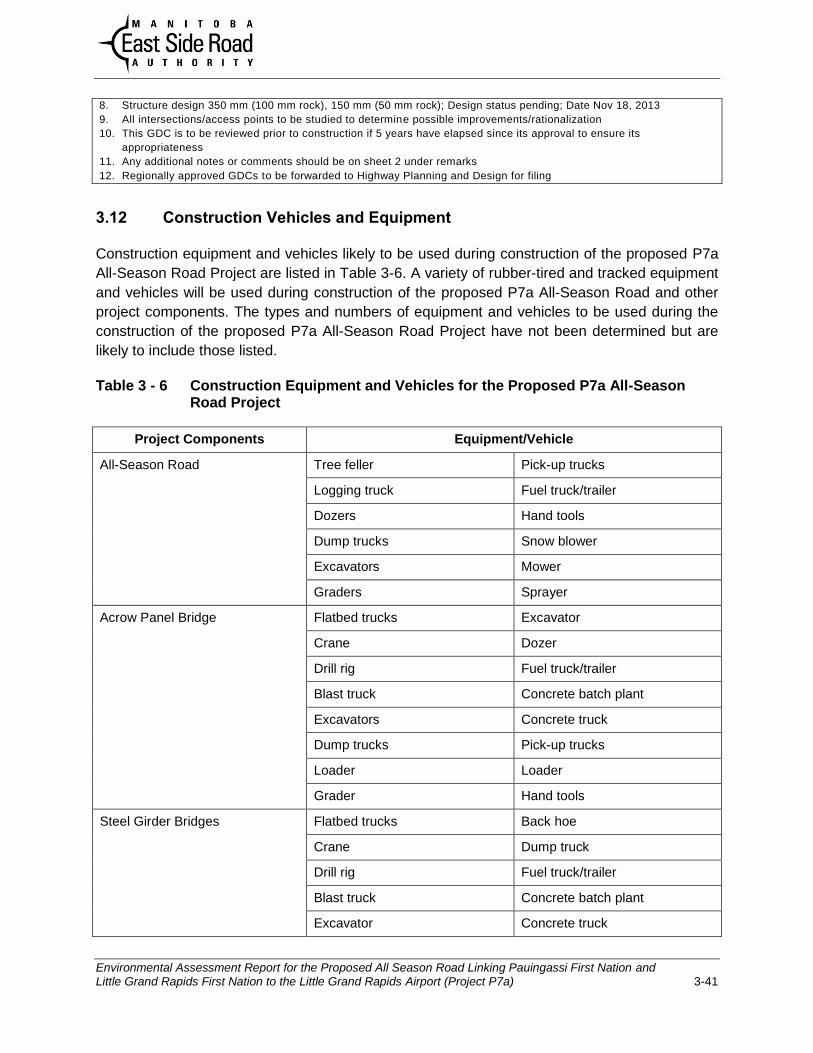
Environmental Assessment Report for the Proposed All Season Road Linking Pauingassi First Nation and Little Grand Rapids First Nation to the Little Grand Rapids Airport (Project P7a) 3-41
8. Structure design 350 mm (100 mm rock), 150 mm (50 mm rock); Design status pending; Date Nov 18, 2013
9. All intersections/access points to be studied to determine possible improvements/rationalization
10. This GDC is to be reviewed prior to construction if 5 years have elapsed since its approval to ensure its
appropriateness
11. Any additional notes or comments should be on sheet 2 under remarks
12. Regionally approved GDCs to be forwarded to Highway Planning and Design for filing
3.12 Construction Vehicles and Equipment
Construction equipment and vehicles likely to be used during construction of the proposed P7a
All-Season Road Project are listed in Table 3-6. A variety of rubber-tired and tracked equipment
and vehicles will be used during construction of the proposed P7a All-Season Road and other
project components. The types and numbers of equipment and vehicles to be used during the
construction of the proposed P7a All-Season Road Project have not been determined but are
likely to include those listed.
Table 3 - 6 Construction Equipment and Vehicles for the Proposed P7a All-Season Road Project
Project Components Equipment/Vehicle
All-Season Road
Tree feller Pick-up trucks
Logging truck Fuel truck/trailer
Dozers Hand tools
Dump trucks Snow blower
Excavators Mower
Graders Sprayer
Acrow Panel Bridge
Flatbed trucks Excavator
Crane Dozer
Drill rig Fuel truck/trailer
Blast truck Concrete batch plant
Excavators Concrete truck
Dump trucks Pick-up trucks
Loader Loader
Grader Hand tools
Steel Girder Bridges
Flatbed trucks Back hoe
Crane Dump truck
Drill rig Fuel truck/trailer
Blast truck Concrete batch plant
Excavator Concrete truck

Environmental Assessment Report for the Proposed All Season Road Linking Pauingassi First Nation and Little Grand Rapids First Nation to the Little Grand Rapids Airport (Project P7a) 3-42
Project Components Equipment/Vehicle
Loader Pick-up trucks
Grader Hand tools
Dozers
Culvert Stream Crossings
Excavator Dump truck
Back hoe Pick-up trucks
Grader
Temporary Construction Bridges Flatbed truck Backhoe
Excavator Dump truck
Loader Pick-up truck
Grader Hand tools
Dozer
Temporary Access Roads Tree feller Dump truck
Hand tools Grader
Dozer Pick-up trucks
Quarries and Borrow Areas Drill rig Loader
Blast truck Dump truck
Rock crusher Grader
Excavator Pick-up trucks
Dozer Generator
Temporary Construction Staging
Areas
Semi-trailers Dozer
Excavator Grader
Dump truck Pick-up trucks
Fuel truck Hand tools
Back hoe Generator
Temporary Construction Camps Excavator Grader
Dump truck Pick-up trucks
Fuel truck Hand tools
Back hoe Generator
Dozer All-terrain vehicles

Environmental Assessment Report for the Proposed All Season Road Linking Pauingassi First Nation and Little Grand Rapids First Nation to the Little Grand Rapids Airport (Project P7a) 3-43
3.13 Project Construction Materials
Construction of the proposed P7a All-Season Road Project will require various quantities of
locally available raw materials available on provincial Crown land and Federal Reserve lands.
Table 3-7 indicates the type of raw material and the estimated quantities required.
Table 3 - 7 Raw Materials Required for the Proposed P7a All-Season Road Project
Raw Material Required Estimated Quantity Unit
Composite Excavation* 600,000 m3
Solid Rock Excavation 120,000 m3
TG Class D 60,000 m3
Quarried Rock Base Course D 180,000 m3
Stone Riprap Class 350 2,000 m3
* Existing suitable composite material from areas above the road bed elevation, ditches and within the
100 m right-of-way will be used.
Construction materials likely to be used for the proposed P7a All-Season Road Project by are
listed in Table 3-8 by project component. The type and amount of construction materials have
not been fully determined but are likely to include those listed.
Table 3 - 8 Construction Materials for the Proposed P7a All-Season Road Project
Project Components Construction Materials Use
All-Season Road
Crushed rock Road bed
Granular materials Road bed
Clay Road bed
Riprap Erosion protection
Geotextile Liner
Organic materials Shoulder
Acrow Panel Bridges
Steel Girders
Concrete Abutment’s
Pressure treated wood Bridge bed
Granular materials Abutments
Organic materials Shoulder/reclamation
Steel Girder Bridges
Steel Girders
Concrete Abutments/bridge bed
Granular materials Abutments

Environmental Assessment Report for the Proposed All Season Road Linking Pauingassi First Nation and Little Grand Rapids First Nation to the Little Grand Rapids Airport (Project P7a) 3-44
Project Components Construction Materials Use
Organic materials Shoulder/reclamation
Riprap Erosion protection
Culvert Stream Crossings
Steel culverts Water passage
Riprap Erosion protection
Crushed rock Road bed
Granular materials Embedding
Organic materials Reclamation
Temporary Construction Bridges Steel Girders
Concrete Abutment’s
Pressure treated wood Bridge bed
Granular materials Abutments
Organic materials Shoulder/reclamation
Temporary Access Roads
Granular materials Road bed
Organic soil Reclamation
Quarries and Borrow Areas Crushed rock Reclamation
Granular materials Reclamation
Organic materials Reclamation
Temporary Construction Staging
Areas
Granular materials Site pad
Organic soil Reclamation
Temporary Construction Camps Granular materials Site pad
Wood Construction
Metal Construction
Organic materials Reclamation
3.14 Fuels and Hazardous Materials
Expected fuels and hazardous materials for the proposed P7a All-Season Road Project are
summarized in Table 3-9 by project component. Fuels and other hazardous materials will be
transported, stored, dispensed and managed in accordance with the National Fire Code of
Canada, The Transportation of Dangerous Good Act (Dangerous Goods Handling and
Transportation, Environmental Accident Reporting and Storage and Handling of Petroleum
Products and Allied Products Regulation).

Environmental Assessment Report for the Proposed All Season Road Linking Pauingassi First Nation and Little Grand Rapids First Nation to the Little Grand Rapids Airport (Project P7a) 3-45
Table 3 - 9 Fuels and Hazardous Materials for the Proposed P7a All-Season Road Project
Project Components Fuel/Materials Purpose
All-Season Road
Diesel Construction equipment/vehicle fuel
Gasoline Construction equipment/vehicle fuel
Propane Construction equipment/vehicle fuel
Heating trailers/structures
Oil Construction equipment/vehicle motor lube
Hydraulic fluid Construction equipment
Acrow Panel Bridges
Diesel Construction equipment/vehicle fuel
Gasoline Construction equipment/vehicle fuel
Propane Construction equipment/vehicle fuel
Heating trailers/structures
Heating under hoarding
Acetylene Cutting steel
Steel Girder Bridges Diesel Construction equipment/vehicle fuel
Gasoline Construction equipment/vehicle fuel
Propane Construction equipment/vehicle fuel
Heating trailers/structures
Heating under hoarding
Oil Construction equipment/vehicle motor lube
Hydraulic fluid Construction equipment
Acetylene Cutting steel
Culvert Stream Crossings
Diesel Construction equipment/vehicle fuel
Gasoline Construction equipment/vehicle fuel
Propane Construction equipment/vehicle fuel
Oil Construction equipment/vehicle motor lube
Hydraulic fluid Construction equipment
Oil Construction equipment/vehicle motor lube
Hydraulic fluid Construction equipment
Temporary Construction
Bridges
Diesel Construction equipment/vehicle fuel
Gasoline Construction equipment/vehicle fuel
Propane Construction equipment/vehicle fuel
Oil Construction equipment/vehicle motor lube
Hydraulic fluid Construction equipment

Environmental Assessment Report for the Proposed All Season Road Linking Pauingassi First Nation and Little Grand Rapids First Nation to the Little Grand Rapids Airport (Project P7a) 3-46
Project Components Fuel/Materials Purpose
Oil Construction equipment/vehicle motor lube
Hydraulic fluid Construction equipment
Acetylene Cutting steel
Temporary Access Roads
Diesel Construction equipment/vehicle fuel
Gasoline Construction equipment/vehicle fuel
Propane Construction equipment/vehicle fuel
Oil Construction equipment/vehicle motor lube
Hydraulic fluid Construction equipment
Quarries and Borrow Areas Diesel Construction equipment/vehicle fuel
Gasoline Construction equipment/vehicle fuel
Propane Construction equipment/vehicle fuel
Oil Construction equipment/vehicle motor lube
Hydraulic fluid Construction equipment
Temporary Construction
Staging Areas
Diesel Construction equipment/vehicle fuel
Electrical generator
Gasoline Construction equipment/vehicle fuel
Propane Construction equipment/vehicle fuel
Heating trailers/structures
Oil Construction equipment/vehicle motor lube
Hydraulic fluid Construction equipment
Temporary Construction
Camps
Diesel Electrical generator
Gasoline Vehicles/equipment
Propane Heating/cooking
Oil Construction equipment/vehicle motor lube
Hydraulic fluid Construction equipment
3.15 Potable Water Supply
Potable water for the proposed P7a All-Season Road Project will be trucked from existing
sources including Pauingassi and Little Grand Rapids First Nations, as required, to the
construction camps. Depending upon availability and with prior approval, groundwater may be
obtained from wells drilled on site.

Environmental Assessment Report for the Proposed All Season Road Linking Pauingassi First Nation and Little Grand Rapids First Nation to the Little Grand Rapids Airport (Project P7a) 3-47
3.16 Waste Disposal and Treatment
Domestic solid waste will be collected and transported to the nearest community landfill in
Pauingassi and Little Grand Rapids First Nations or Little Grand Rapids Northern Affairs
Community. Recyclable materials will be segregated and stored in designated areas and
containers for removal as conditions permit. Septage waste at construction camps or sites will
be stored in approved containers and will be hauled for disposal and treatment at either the
sewage treatment plant in Pauingassi First Nation or the aerated sewage lagoon at Little Grand
Rapids First Nation. Hazardous materials used for the Project include fuel and lubricants used
by the construction vehicles, equipment and machinery, stationary and portable generators, and
other portable equipment (e.g., pumps, chain saws). Waste petroleum produces (e.g.,
lubricants, oils, greases) derived from construction vehicles and equipment will be collected and
stored in designated areas and containers until they can be removed from site for recycling or
disposal through a licenced waste disposal/treatment company.
Waste disposal and treatment for the proposed P7a All-Season Road Project is summarized in
Table 3-10. Solid, liquid and hazardous wastes from the road project will be collected, stored,
transported, disposed of and/or treated in accordance with The Environment Act (Waste
Disposal Regulation) and The Transportation of Dangerous Good Act (Dangerous Goods
Handling and Transportation, Environmental Accident Reporting Regulation, and Storage and
Handling of Petroleum Products and Allied Products Regulation). If contaminated soil is
discovered during the life of the proposed P7a All-Season Road and its components the
affected site will be assessed and any soil determined to be contaminated will be managed on-
site or removed to an approved treatment site.

Environmental Assessment Report for the Proposed All Season Road Linking Pauingassi First Nation and Little Grand Rapids First Nation to the Little Grand Rapids Airport (Project P7a) 3-48
Table 3 - 10 Waste Disposal and Treatment for the Proposed P7a All-Season Road Project
Project Components Solid Waste Liquid Waste Hazardous Waste
All-Season Road Trees windrowed and
burned on-site
Porta-potties will be
used for human
wastes.
None expected
Acrow Panel Bridges Waste construction
materials collected and
removed from site to an
approved facility.
Porta-potties will be
used for human
wastes.
Any hazardous
wastes will be stored
and transported to an
approved facility.
Steel Girder Bridges Waste construction
materials collected and
removed from site to an
approved facility.
Porta-potties will be
used for human
wastes.
Any hazardous
wastes will be stored
and transported to an
approved facility.
Culvert Stream
Crossings
Waste construction
materials collected and
removed from site to an
approved facility.
Porta-potties will be
used for human
wastes.
None expected.
Temporary
Construction Bridges
Trees windrowed and
burned on-site
Porta-potties will be
used for human
wastes.
Any hazardous
wastes will be stored
and transported to an
approved facility.
Temporary Access
Roads
Trees windrowed and
burned on-site.
Porta-potties will be
used for human
wastes.
None expected.
Quarries and Borrow
Areas
Trees windrowed and
burned on-site
Porta-potties will be
used for human
wastes.
Some contamination
possible.
Temporary
Construction Staging
Areas
Waste construction and
other materials collected
and removed from site to an
approved facility.
Human wastes will be
contained and taken to
an approved treatment
facility.
Any hazardous
wastes will be stored
and transported to an
approved facility.
Temporary
Construction Camps
Waste construction and
other materials collected
and removed from site to an
approved facility.
Human wastes will be
contained and taken to
an approved treatment
facility.
Any hazardous
wastes will be stored
and transported to an
approved facility.

Environmental Assessment Report for the Proposed All Season Road Linking Pauingassi First Nation and Little Grand Rapids First Nation to the Little Grand Rapids Airport (Project P7a) 3-49
3.17 Project Workforce
The anticipated workforce for the proposed P7a All-Season Road Project is summarized in
Table 3-11. Construction will be carried out under contracts tendered and managed by ESRA.
Presently, the number, scope and magnitude of the contracts are not fully known. ESRA
employees will be involved in the planning and design of the proposed Road Project, and will
manage and/or supervise pre-construction, construction and operation and maintenance
activities. Construction activities will be monitored by ESRA inspectors and contractors if
tendered. One part-time ESRA employee and three contract people will be required for
operation and maintenance activities on a full-time basis after commissioning of the P7a All-
Season Road.
Table 3 - 11 Estimated Workforces for the Proposed P7a All-Season Road Project
Project Components
Pre-
Construction Construction
Operation and
Maintenance
Contract Staff Contract Staff Contract Staff
All-Season Road 3 2 25 5 3 1(PT)
Acrow Panel Bridges 0 0 20 3 Incl. above Incl. Above
Temporary Construction
Camps
2 1 5 1 - -
3.18 Project Schedule
The schedule to achieve an in-service date of 2020 for the proposed P7a All-Season Road
Project is summarized in Table 3-12.

Environmental Assessment Report for the Proposed All Season Road Linking Pauingassi First Nation and Little Grand Rapids First Nation to the Little Grand Rapids Airport (Project P7a) 3-50
Table 3 - 12 Planned Schedules for the Proposed P7a All-Season Road Project
Project Components Project Phase Start Date Completion Date
All-Season Road
Planning/Design 2014 2015
Construction 2016 2020
Operation/Maintenance 2021 Ongoing
Acrow Panel Bridges Planning/Design 2014 2015
Construction 2017 2019
Operation/Maintenance 2019 Ongoing
Decommissioning ~2040 ~2040
Steel Girder Bridges Planning/Design To be determined To be determined
Construction To be determined To be determined
Operation/Maintenance To be determined To be determined
Culvert Stream
Crossings
Planning/Design 2014 2015
Construction 2016 2019
Operation/Maintenance 2019 Ongoing
Temporary
Construction Bridges
Planning/Design 2014 2015
Construction 2017 2018
Operation/Maintenance 2017 2018
Decommissioning 2018 2018
Quarries and Borrow
Areas and Temporary
Aceess Roads
Planning/Design 2014 2018
Construction 2016 2019
Operation/Maintenance 2016 2019
Decommissioning 2020 2020
Temporary
Construction Staging
Areas
Planning/Design 2014 2015
Construction 2016 2020
Operation/Maintenance 2016 2020
Decommissioning 2020 2020
Temporary
Construction Camps
Planning/Design 2014 2015
Construction 2016 2020
Operation/Maintenance 2016 2020
Decommissioning 2020 2020

Environmental Assessment Report for the Proposed All Season Road Linking Pauingassi First Nation and Little Grand Rapids First Nation to the Little Grand Rapids Airport (Project P7a) 3-51
3.19. Project Funding
The total cost for construction of the proposed P7a All-Season Road Project is estimated to be
$50 million with bridges. Initial operating costs for the proposed road project are estimated to be
$6 million per year and are subject to the cost of inflation over time. The source of funding for
construction and operation of the proposed P7a All-Season Road Project is the Manitoba
Government. Funding for the Community Access Roads on First Nation Reserve land is being
requested from Aboriginal Affairs and Northern Development Canada in support of Aboriginal
economic development with Little Grand Rapids First Nation, Pauingassi First Nations and
ESRA as co-applicants.
3.20 Summary
This chapter of the environmental assessment report provided a description of the proposed All
Season Road Project linking Pauingassi First Nation and Little Grand Rapids First Nation to the
Little Grand Rapids Airport. The project description included its regional context, location on the
east of Lake Winnipeg, ownership of the land, alternatives means of carrying out the project,
construction stages, components and activities, construction materials, waste products,
workforce, schedule and funding. The proposed P7a All-Season Road Project is described to
facilitate the identification and analysis of potential environmental effects, and the mitigation of
adverse effects in the subsequent chapters.