3 Ecology - WUR
14
3 Ecology 3.1 Principal Ecological Systems In the inventory area, two principal ecological systems can be distinguished: forest and savanna. The boundary between these two systems is perhaps the most basic divide in the ecology of West Africa. This boundary is gradual; there is no abrupt change from forest to savanna. Nor does this boundary deny the variability that occurs within each system. Within the forest system, different types of forest can be distinguished and the same holds for the savanna. Ecological systems show very complex interrelations between their different com- pounds (e.g. climate, soils, hydrology, flora, and fauna, including man). In describing ecological systems, it is hardly possible to separate the plant component from the soil, or to distinguish these from the animal component. Furthermore, most agricultur- al systems have striking ecological implications and it is often useful to treat man and his agricultural behaviour as an integral part of the (agro-)ecological complex. It is beyond the scope of this book to describe in detail the complexity of the different ecological systems. Chapter 2 has already discussed the climatological parameters, the morphology, the hydrology, and the soils of West Africa. The present chapter will discuss only the major differences between the forest and savanna ecologies, the vegetation, and the effects of human interventions on these ecological systems. 3.1.1 Main Characteristics of the Forest Ecology In West Africa, the extent of the forest is restrictell to the Equatorial Forest Zone, as was described in Section 2. I. This Zone occurs in the southwestern and the southeas- tern parts of the inventory area, where the mean annual precipitation varies from 1,250 to more than 3,000 mm. The rainfall pattern can be monomodal, pseudo-bimo- dal, or bimodal. The factors that determine the differences in floristic composition of the forests are the amounts and distribution of rainfall, and the differences in soils, physiography, and hydrology. The structure of these rain forests is very dense, with a closed canopy of woody plants. The sheer bulk of the forest vegetation is as high as 335,000 kg/ha (oven-dry weight), excluding roots (Nye and Greenland 1960). Internally, the forest is vertically arranged in different distinct layers: the undergrowth, tall trees which form the closed canopy, and very tall trees which tower above the closed canopy. Generally, intermedi- ate layers are also present. Because of the structure of the forest vegetation, the food niches and the microcli- mate within the forests are layered too. The plant-faunal relationships are strongly correlated with this layered structure (Figure 3.1). To some extent, the ecological system of the forest is buffered against changes in atmospheric conditions. The dense canopy of the forest vegetation protects the inner microclimate from the effects of short-term atmospheric changes outside. Conse- 69
Transcript of 3 Ecology - WUR
3 Ecology
3.1 Principal Ecological Systems
In the inventory area, two principal ecological systems can be distinguished: forest and savanna. The boundary between these two systems is perhaps the most basic divide in the ecology of West Africa. This boundary is gradual; there is no abrupt change from forest to savanna. Nor does this boundary deny the variability that occurs within each system. Within the forest system, different types of forest can be distinguished and the same holds for the savanna.
Ecological systems show very complex interrelations between their different com- pounds (e.g. climate, soils, hydrology, flora, and fauna, including man). In describing ecological systems, it is hardly possible to separate the plant component from the soil, or to distinguish these from the animal component. Furthermore, most agricultur- al systems have striking ecological implications and it is often useful to treat man and his agricultural behaviour as an integral part of the (agro-)ecological complex.
It is beyond the scope of this book to describe in detail the complexity of the different ecological systems. Chapter 2 has already discussed the climatological parameters, the morphology, the hydrology, and the soils of West Africa. The present chapter will discuss only the major differences between the forest and savanna ecologies, the vegetation, and the effects of human interventions on these ecological systems.
3.1.1 Main Characteristics of the Forest Ecology
In West Africa, the extent of the forest is restrictell to the Equatorial Forest Zone, as was described in Section 2. I . This Zone occurs in the southwestern and the southeas- tern parts of the inventory area, where the mean annual precipitation varies from 1,250 to more than 3,000 mm. The rainfall pattern can be monomodal, pseudo-bimo- dal, or bimodal. The factors that determine the differences in floristic composition of the forests are the amounts and distribution of rainfall, and the differences in soils, physiography, and hydrology.
The structure of these rain forests is very dense, with a closed canopy of woody plants. The sheer bulk of the forest vegetation is as high as 335,000 kg/ha (oven-dry weight), excluding roots (Nye and Greenland 1960). Internally, the forest is vertically arranged in different distinct layers: the undergrowth, tall trees which form the closed canopy, and very tall trees which tower above the closed canopy. Generally, intermedi- ate layers are also present.
Because of the structure of the forest vegetation, the food niches and the microcli- mate within the forests are layered too. The plant-faunal relationships are strongly correlated with this layered structure (Figure 3.1).
To some extent, the ecological system of the forest is buffered against changes in atmospheric conditions. The dense canopy of the forest vegetation protects the inner microclimate from the effects of short-term atmospheric changes outside. Conse-
69

Figure 3.1 The structure of the lowland rain forest and the stratification of the habitat of some mammals and snakes (after: Moss 1969; adapted)
quently, changes in temperature, relative humidity, and other variables are much less in magnitude, and lag behind those outside the canopy. This is mainly related to the decreased air movement effected by the forest.
Because of the long humid period (P > ET,; see Section 2.1.6) and the forest-induced humid microclimate, the soils of the forests remain moist throughout the year.
Under the high rainfall occurring in the Equatorial Forest Zone, the soils of the forests are strongly weathered and leached. The mineral fraction of these soils consists mainly of kaolinite and sesquioxides with a very low inherent fertility. The fertility of the forest soils is mainly stipulated by the organic matter content of the topsoils.
The rapid rate ofmineralization of the organic matter is another striking characteris- tic of the forest ecological system.
3.1.2 Main Characteristics of the Savanna Ecology
The savanna of West Africa occurs in the northern and central-southern parts of the inventory area. It occupies the Guinea Savanna and the Sudan Savanna Zones, as described in Section 2.1. The mean annual precipitation varies from 550 mm in the north of the Sudan Savanna Zone to 2,500 mm in the southwestern part of the Guinea Savanna Zone. The rainfall pattern is predominantly monomodal, but locally it is pseudo-bimodal or bimodal. The latter pattern occurs only in the southernmost parts
70

of the Guinea Savanna Zone. As in the forest ecology, the differences in floristic com- position of the savanna are determined by the range of total amounts of rainfall and its distribution, the soils, the hydrology, and the physiography.
The structure of the savanna is much more open than that of the forest and varies from a more or less closed savanna woodland in the more humid zone, to grasses with sparse trees in the drier parts (Figure 3.2). The sheer bulk of the savanna vegeta- tion is only as high as 67,000 kg/ha (oven-dry weight), excluding roots (Nye and Green- land 1960).
Unlike the forests, the savanna vegetation is hardly arranged in different vertical layers, especially the more open vegetation in the northern part of the inventory area. The graminaceous layer is the most prominent element of the savanna ecological sys- tem. Almost all human and faunal activity is concentrated in this layer.
Because of its open structure, the savanna vegetation does not create its own micro- climate and is not buffered against changes in temperature, relative humidity, and other climatological variables. As a result, sunshine and rains have a direct impact on the soil surface.
The water and nutrient cycles of the savanna ecological system are determined by the seasonality of water availability. Because of the prevailing short humid period in the Savanna Zones of West Africa and the open structure of their vegetation, the soils of the Savanna Zones dry up for a certain period during the dry season. This process is strengthened by the relatively shallow root system of the savanna vegetation, which is not as effective as the forest in pumping water from great depths. Water deficiency in the dry season has an inhibiting effect on the nutrient uptake by the vegetation. For that reason, the nutrient cycle is seasonal compared with the relative continuity under forest. These effects may be further strengthened where atmospheric water cannot be absorbed by the soil because of crust formation and surface sealing.
a
N
b
C
Figure 3.2 Different types of savanna: a: woodland savanna; b: tree savanna; c: shrub savanna (after: Tro- chain 1957; adapted)
71

The lower rainfall in the Guinea Savanna and the Sudan Savanna Zones, as well as the capillary rise of groundwater prevailing during the dry season, is reflected in the general occurrence of less-leached soils in these Zones, as compared with the Equa- torial Forest Zone. Consequently, inherent fertility levels in the Savanna Zones are somewhat higher too.
The natural plant-faunal relationships in the savanna are different from those in rain forest areas. The diversity of animal species in the savanna is less than in the forest, but the number of animals occurring per species is larger.
Nevertheless, livestock, which, over the years, has been kept in large numbers, has replaced the original herds of grazers with their associated predators. The predator food niches are nowadays occupied by man. This has an impact on the vegetation, both because of the cattle’s food preferences for certain graminaceous species and because of the agricultural practices (i.e. the burning of grasslands at the beginning or end of the dry season). This concentration of interventions in the graminaceous element of the savanna ecological system has generally resulted in the degradation of the habitat.
3.1.3 Ecological Differences between Uplands and Bottomlands of Inland Valleys
Ecological differences between the different landscape elements of the inland valleys (i.e. the uplands, colluvial footslopes and valley fringes, and valley bottoms) are mainly the result of variations in hydrology.
The valley bottoms in the Equatorial Forest Zone are submerged for most of the year and have the watertable near the surface for the rest of the year. Because of this poor drainage, the vegetation of the valley bottoms contains species adapted to this wet environment, while the vegetation on the upland is more adapted to the well- drained conditions under high rainfall. In the uplands, however, as well as in the valley bottoms, the water and nutrient cycles are continuous throughout the year.
In the savanna areas, the valley bottoms and valley fringes represent environments that are distinctly different from those on the uplands. In the valley bottoms and fringes, the watertable fluctuates strongly, creating a wet environment in the rainy season and, in the dry season, dry conditions with a deep watertable. These ecological differences create habitats for very different plant species and animals.
In the uplands, with permanently deep groundwater, the growing period is deter- mined strictly by the length of the rainy period. As a result, the water and nutrient cycles are seasonal too.
Because of the high watertable in the beginning of the dry season and the lateral groundwater flow from the uplands, the growing period in the valley bottoms and fringes is prolonged considerably, especially in the more humid areas (Guinea Savanna Zone). Because of lateral groundwater flow to the valley bottoms, nutrient cycling continues also after the rains have ceased. It remains seasonal, however, as in the uplands.
72
3.2 The Vegetation
3.2.1 General
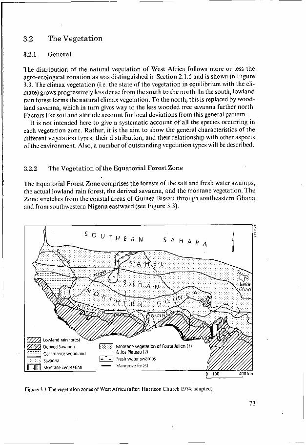
The distribution of the natural vegetation of West Africa follows more or less the agro-ecological zonation as was distinguished in Section 2.1.5 and is shown in Figure 3.3. The climax vegetation (i.e. the state of the vegetation in equilibrium with the cli- mate) grows progressively less dense from the south to the north. In the south, lowland rain forest forms the natural climax vegetation. To the north, this is replaced by wood- land savanna, which in turn gives way to the less wooded tree savanna further north. Factors like soil and altitude account for local deviations from this general pattern.
It is not intended here to give a systematic account of all the species occurring in each vegetation zone. Rather, it is the aim to show the general characteristics of the different vegetation types, their distribution, and their relationship with other aspects of the environment. Also, a number of outstanding vegetation types will be described.
3.2.2 The Vegetation of the Equatorial Forest Zone
The Equatorial Forest Zone comprises the forests of the salt and fresh water swamps, the actual lowland rain forest, the derived savanna, and the montane vegetation. The Zone stretches from the coastal areas of Guinea Bissau through southeastern Ghana and from southwestern Nigeria eastward (see Figure 3.3).
Figure 3.3 The vegetation zones of West Africa (after: Harrison Church 1974; adapted)
73

The salt-water swamp forest is the vegetation that occurs along the coast and estuaries which are under tidal influence. During high tides, the muddy soils prevailing in these areas become saturated with saline or brackish water. In this physical environment, the vegetation is mainly formed by mangroves, with their characteristic stilt roots. In the areas close to the sea, which are flooded every high tide, Rhizophora racemosa and Rhizophora mangle occur. On the landward, higher, and less frequently flooded margins of the salt-water swamps, the rhizophora gives way to avicennia mangroves (Avicennia africana and A . nitidu) and, higher still, to herbaceous plant species like Sesuvium, Philox- erus, Eleocharis, and Paspalum (Dent 1986; Langenhoff 1986; Chapman 1977).
The combination of mangrove vegetation, with its high production of organic mat- ter, and the regular flooding with saline water results in the formation of sulphides in the soils (potential acid sulphate soils). In West Africa, as in other regions of the world, no clear relation has been found between the type of mangrove vegetation and the amount of sulphide production (van der Kevie 1973; Thomas et al. 1979; Dent 1986; Janssen et al. 1993). Upon aeration (e.g. through artificial drainage), the sul- phides in these soils oxidize to form sulphuric acid, rendering the soils extremely acid (pH < 3.5; actual acid sulphate soils).
In the least saline areas of Senegal, Guinea Bissau, Sierra Leone, and Nigeria, the mangrove vegetation has been eliminated to enable rice cultivation. The heavy rainfall and/or flooding by rivers in these areas is used to flush salt and free acids from the soil.
Fresh-water swamp forest is found under swampy conditions further inland, where there is no longer a tidal influence. It is widespread in the lower Niger Delta in Nigeria. The vegetation is dominated by raphia palms (Raphia vinifera and R . hookeri) and has an open canopy in which tangled shrubs and lianes with hooked spines form a dense undergrowth.
The West African lowland rain forests are located within two blocks, the first covering parts of Sierra Leone, Liberia, Ivory Coast, and Ghana, and the second, parts of Nigeria and Cameroon. They are separated by the tongue of the Guinea Savanna which comes down in the Togo Gap. This separation is mainly due to lower rainfall and the action of man within the Gap.
The semi-evergreen or evergreen lowland rain forest vegetation is vertically arranged in different distinct layers or storeys. White (1983) distinguishes the following stratifi- cation: - Lower storey: dense undergrowth (3 - 5 m high), made up of low plants, shrubs,
- Middle storey: huge trees (20 - 30 m high), with dark green and dense foliage, and
- Upper storey: very tall and straight trees (30 to 50 m or more in height), which
The canopy of the upper storey is usually discontinuous, whereas the lower storeys have a more continuous canopy.
Moss (1969) gives a slightly different subdivision. He distinguishes a shrub layer, an understorey (up to 20 m high), the main canopy (up to 30 m high), and emergents (up to 45 m high) (see Figure 3.1).
and ferns;
many branches which grow on thick woody trunks;
have few leaves, grey trunks, and buttressed roots. '
The lowland rain forest comprises many different species. The hard woods/timber species are the most famous, e.g. Khaya ivorensis and K. anthotheca (both mahoganies), Entandrophragma cylindricum (sapele), Guarea cedrata (guarea), and Lovoa trichiloides (African walnut).
Variations in the species composition of the lowland rain forests are mainly caused by differences in the physical environment (variations in relief, soil, slope, and drainage).
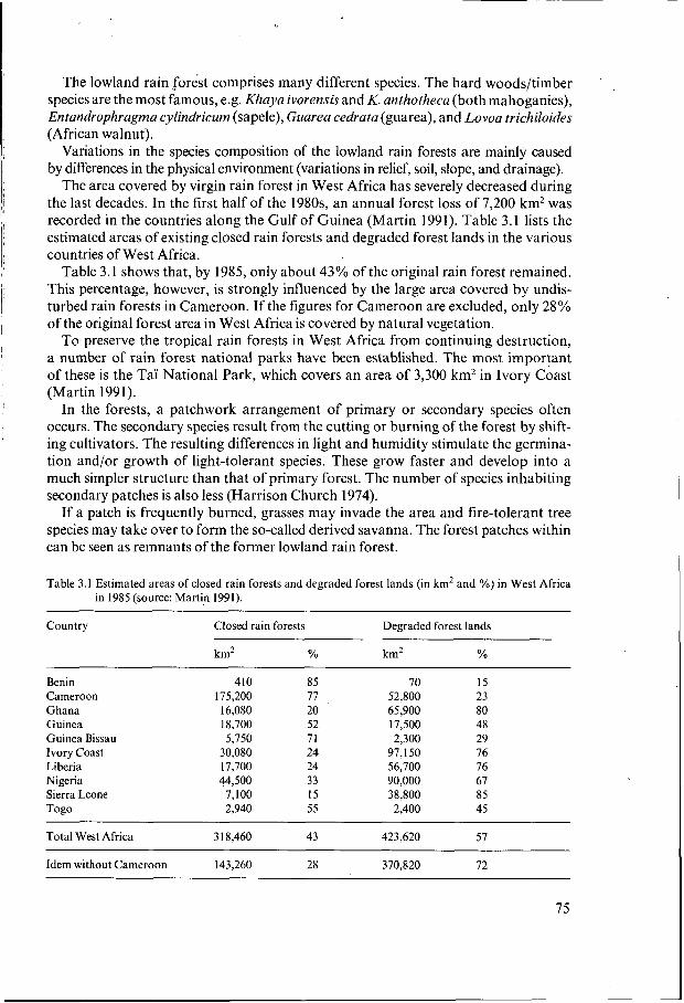
The area covered by virgin rain forest in West Africa has severely decreased during the last decades. In the first half of the 1980s, an annual forest loss of 7,200 km2 was recorded in the countries along the Gulf of Guinea (Martin 1991). Table 3.1 lists the estimated areas of existing closed rain forests and degraded forest lands in the various countries of West Africa.
Table 3.1 shows that, by 1985, only about 43% of the original rain forest remained. This percentage, however, is strongly influenced by the large area covered by undis- turbed rain forests in Cameroon. If the figures for Cameroon are excluded, only 28% of the original forest area in West Africa is covered by natural vegetation.
To preserve the tropical rain forests in West Africa from continuing destruction, a number of rain forest national parks have been established. The most important of these is the Taï National Park, which covers an area of 3,300 km2 in Ivory Coast (Martin 1991).
In the forests, a patchwork arrangement of primary or secondary species often occurs. The secondary species result from the cutting or burning of the forest by shift- ing cultivators. The resulting differences in light and humidity stimulate the germina- tion and/or growth of light-tolerant species. These grow faster and develop into a much simpler structure than that of primary forest. The number of species inhabiting secondary patches is also less (Harrison Church 1974).
If a patch is frequently burned, grasses may invade the area and fire-tolerant tree species may take over to form the so-called derived savanna. The forest patches within can be seen as remnants of the former lowland rain forest.
Table 3.1 Estimated areas of closed rain forests and degraded forest lands (in km2 and %) in West Africa in 1985 (source: Martin 1991).
Country Closed rain forests Degraded forest lands
km2 % km2 %
Benin 410 85 70 15 Cameroon 175,200 77 52,800 23 Ghana 16,080 20 65,900 80 Guinea 18,700 52 17,500 48 Guinea Bissau 5,750 71 2,300 29 Ivory Coast 30,080 24 97,150 76 Liberia 17,700 24 56,700 76 Nigeria 44,500 33 90,000 67 Sierra Leone 7,100 15 38,800 85 Togo 2,940 55 2,400 45
Total West Africa 3 18,460 43 423,620 57 ~
Idem without Cameroon 143,260 28 370,820 72
75
The occurrence of montane vegetation is determined by the altitude. Altitude may mod- ify vegetation because of the lower temperature, increased and more constant humidity and cloudiness, less solar radiation, and less evaporation. Consequently, in the Gui- nean Highlands, on Mount Cameroon, and in the Cameroon Highlands, a tall cano- pied montane rain forest is found at elevations above 1,000 m. From approximately 1,200 m, the forests are saturated in mists, and temperate tree species are quite com- mon. Above 1,500 m, montane woodland occurs with abundant grasses. Grassland may also occur at lower altitudes as the result of frequent burning.
3.2.3 The Vegetation of the Guinea Savanna Zone
The vegetation of the Guinea Savanna Zone comprises the casamance woodland (Gui- nea Bissau, The Gambia, and southern Senegal), the guinea savanna, and the vegeta- tion types of the Fouta Jallon (Guinea) and Jos Plateau (Nigeria). This Zone stretches from Guinea Bissau eastward to Nigeria, including the Togo Gap (see Figure 3.3).
Characteristic of this Zone is the woodland savanna, which consists of an open stand of trees, the crowns of which form a canopy from 8 - 20 m or more in height and cover at least 40% of the surface (White 1983). The crowns of adjacent trees are often in contact but are not densely interlocking as in the Equatorial Forest climax vegetation (see Figure 3.2). There is a groundcover of herbaceous tussock grasses, up to 2 m high.
The casamance woodland is the woodland savanna around the Casamance River in Guinea Bissau, The Gambia, and southern Senegal. The structure of the vegetation consists of two storeys. The upper storey (up to 15 - 20 m high) consists dominantly of only four tree species: Parinari excelsa, Erythrophleum guineense, Detarium senega- lense, and Afzelia africana. The trees are low-branching and spreading. The lower storey (up to 3 - 6 m high) consists of bushes, lianes, and herbaceous plants.
The guinea savanna covers the most extensive region of the West African savanna. This woodland savanna can be divided into two types: - The southern guinea savanna, with a tree cover that varies from forest in the south
to a woodland savanna in the north. The main tree species are Daniellia oliveri, Lophira alata, and Terminalia glaucescens. Significant grass genera are Andropogon, Cymbopogon, Hyparrhenia, Pennisetum, and Setaria.
- The northern guinea savanna, a more open woodland savanna, which is character- ized by Isoberlinia spp., in association with the perennial grass Hyparrhenia spp. Its physiognomy is rather similar to that of the southern guinea savanna, although poorer and more distinct in its species composition. Common trees are: Isoberlinia dalzielii and Monotes kerstingii. Comm’on grass genera are more or less the same as in the southern guinea savanna. Brachiaria spp., however, takes the place of Setaria.
On the plateaux of the Fouta Jallon (Guinea), with an altitude of up to 1,500 m, no altitudinal gradations of the vegetation occur; nor is there a true montane vegetation. The original climax vegetation may have been lowland rain forest. If it was, however,
76
it must have been exceedingly frail owing to the marginal position-of the Fouta Jallon in both latitude and altitude. Another option for the climax vegetation could be casa- mance woodland, with some lowland rain forest additions. The presence of Parinari excelsa, a typical casamance woodland species, supports this. The original vegetation cover, however, has been almost completely eliminated, leaving lateritic exposures behind, almost bare of soil and vegetation.
The Jos Plateau (Nigeria) is covered by northern guinea savanna at its foothills, to poor woodland savanna above. The original vegetation, whether montane or northern guinean in character, has been thoroughly destroyed. The people living on the Jos Plateau have lost almost 15% of their land to tin-mining activities. This has resulted in an increased pressure on the remaining land. At present, the most accessible areas are almost treeless and are under grass. The mining activities have also impaired the vegetation and drainage. What is left is a highly degraded northern guinea savanna vegetation with some montane additions.
3.2.4 The Vegetation of the Sudan Savanna Zone
In the Sudan Savanna Zone, sudan savanna and fresh-water swamp vegetation of the inland Niger Delta occur. This Zone stretches north of the Guinea Savanna Zone (see Figure '3.3).
The zonal sudan savanna changes from open woodland in the south to tree savanna in the north. The sudan savanna trees have very wide geographical ranges, both longi- tudinal and latitudinal, and wide ecological tolerances. According to White (1983), too few species occur in sufficiently constant association with others over sufficiently extensive areas to permit the recognition of well-defined ecological elements.
Some authors - e.g. Keay (1949), Aubréville (1950), and Chevalier (1951) - have suggested that a dry forest was the original climax vegetation of the Sudan Savanna Zone. On the sandstone plateaus of western Mali, some relics of dry evergreen forest still persist (Jaeger 1968). Because of its favourable climate and soils, this Zone is heavily populated by both man and animals.
Trees, almost always occurring singly, have wide-spreading crowns. The natural vegetation includes tree species of Guiera senegalensis, Combretum glutinosum, Pilio- stigma reticulata, and, in association with water courses, Hyphaene thebaica (doum palm). Most vegetational cover is found in various stages of regeneration following periods of cultivation. Where the fallow period is short and fires are frequent, the trees are often represented by coppice shoots and mature trees of specially preserved species of economic importance. These trees include Parkia spp., Butyrospermum par- kii(karité), Acacia albida, Tamarindus indica (tamarind), and Ceibapentandra (kapok).
The grasses are shorter than in the Guinea Savanna Zone, and they have a different character. Most grasses are annuals because of drought-stress in the long dry period. Commonly occurring annuals include Andropogon pseudapricus, Hyparrhenia, and Loudetia spp. A number of perennials grow vigorously: Andropogon gayanus, Anthro- phora nigritane, Aristida stipoides, Pennisetum setosum, and Hyparrhenia spp.
More to the north, trees with thorns (e.g. Acacia spp.) become more common and the grasses become shorter, less tussocky, and more feathery.
77

The fresh-water swamp vegetation is an azonal type of vegetation which occurs in the inland Niger Delta in Mali. Differences in the vegetation composition are dictated mainly by the hydrological conditions, such as the frequency and duration of flooding and the depth of the water level, and by physiography.
Andropogon and Chloris occur on the infrequently flooded transition zones between the floodplains and the toguéré (i.e. non-flooded areas like dunes and ancient levees). On the shallow and moderately deep flooded parts of the floodplains, an association of Panicum and Eragrostis occurs, and on the flooded levees near the main rivers, Echinochloa and Oryza. On places where the flooding is deep, Vetivera and Mahinot are found.
The vegetation of the non-flooded areas is characterized by Borassus, Ficus, Diospyr- os, Guaera or Acacia, and Cenchrus (Drijver and Marchand 1985, Gallais 1967).
3.3 Uses and Interventions in the Ecological Systems
3.3.1 General
Agricultural ecology in West Africa has been extensively treated by Kowal and Kas- sam (1978), Harrison Church (1974), and Thomas and Whittington (1969). Farming systems have been described by Fiselier (1990), Jansen and Diarra (1990), de Rouw et al. (1990), Turner (1986), Smaling et al. (1985a,b), Broekhuyse and Allen (1984), Kessler and Ohler (1983), and Gleave and White (1969).
3.3.2 Uses and Interventions in the Ecology of the Equatorial Forest Zone
The inland valley bottoms in the Equatorial Forest Zone are flooded for most of the year. Because the environment is unhealthy owing to water-borne diseases (see Chapter 4) and because of the high labour demand for clearing, the valley bottoms are not extensively used for crop production.
If not used for crop production, the inland valleys are traditionally used for gather- ing fruits and nuts, as a source of firewood, and as waterways for transport. Fish, caught in the valley streams or swamps, form an important source of protein.
Often, the wet parts of the inland valleys or parts thereof (mostly the peripheries) are used for growing some vegetables or staples (including rice), crops not much differ- ent from those grown on the uplands.
In the last decades, more and more attention has been given to the potential of the inland valley bottoms for rice production, especially in Sierra Leone and Liberia. It is assumed that, in Sierra Leone, about 40% of the inland valley bottoms are used for rice production in the rainy season.
The uplands in the rain forest zone are used for arable crop production. The most common farming system is shifting cultivation and, to a lesser extent, the bush fallow system. The bush fallow can be seen as an intensive form of shifting cultivation (Ruth- enberg 1980). In this farming system, a new field is required nearly every year. In choosing the location of the field, farmers consider the soil, physiography, and condi- tion of the forest. In case of a secondary forest, this encompasses the age (i.e. the
78

time since last cutting), the structure, and the floristic composition. These factors are important because, owing to the low inherent fertility of the upland soils, the crop thrives on the nutrients present in the ash of the burned forest.
Because of the activities of man, the vegetation pattern of the uplands has been modified in such a way that mosaics of forest regrowth, secondary forest, and derived savanna cover much of the area.
A decrease in yields on the uplands, the higher agricultural potential of the valley bottoms, and the increasing need to spread the risks of crop failure, were reasons for farmers in, for instance Sierra Leone and Liberia, to involve the hydromorphic and wet parts of the inland valleys (i.e. the footslopes and valley bottoms) in their farming system (FAO 1979; Richards 1985 and 1986). The moist conditions of the footslopes and valley bottoms allow flexibility in the period of planting. The fallow periods in the hydromorphic and wet parts of the inland valleys are generally shorter than on the uplands.
Some farmers in Ivory Coast are accustomed to growing rice, mainly on the lower slopes and part of the valley bottoms. The dominant occurrence of raphia palms in the valley bottoms is often an indication of former human activity (de Rouw et al. 1990). Farming systems in the Equatorial Forest Zone are extensively discussed in Chapter 5.
3.3.3 Uses and Interventions in the Ecology of the Savanna Zones
In the Savanna Zones of West Africa, the inland valleys differ significantly in their ecology from the adjacent uplands. Along the streams, gallery forest occurs with its specific vegetation and animal population. This type of forest forms an important corridor for certain animal species and it offers shelter and roosting places for birds. At places, a so-called holy forest occurs near the stream, where the local population buries its deceased or holds certain rituals.
During and after the rainy season, inland valleys offer conditions and habitats that resemble those of the larger floodplains: shallow inundated land, temporary marshes, and receding flood waters that leave a waterbird and wader habitat behind, such as small natural or artificial lakes with drawdown zones that remain attractive to birds (Fiselier 1990).
Regionally, the combination of inland valleys and larger floodplains, as found in the inland Niger Delta in the Sudan Savanna Zone, provides a continuous food supply to palearctic waterbirds and waders. In periods of prolonged drought, the inland Niger Delta also serves as a refuge for birds from the Senegal and Guinea Bissau coastal wetlands (de Bie 1990).
Most inland valleys in the Sudan Savanna Zone dry out completely in the dry season. They therefore contain no fish, except for lung fish.
The presence of any wildlife depends on hunting pressure. Many inland valleys con- tain dry-season pastures that are attractive for grazers, whether these be wild animals or domestic cattle. Drinking water is crucial for mammals and, in the semi-arid regions, its occurrence is largely restricted to river valleys. The combination of drinking water and food makes inland valleys ideal as corridors for migrating animals.
79

Unlike the inland valleys in the Equatorial Forest Zone, most of the inland valleys of the Guinea Savanna and Sudan Savanna Zones are already part of the actual arable and livestock farming systems.
Seasonally-flooded grasslands have always been key elements in the grazing cycle of cattle herds; the forests have always acted as a wood resource, and perennial streams and groundwater seepage have provided drinking water and a sustained water supply to vegetable gardens.
In the western part of West Africa, rice has been grown by smallholders in the inland valleys for a long time, especially in the Guinea Savanna Zone, where rice has been an important staple crop. According to Mohr (l969), this area comprises the upper catchments of the Casamance and Gambia Rivers, south Mali, Burkina Faso, north and west Ivory Coast (Korhogo and Man), Guinea, north Liberia, Sierra Leone, and Guinea Bissau. In this region, valley rice cultivation is still widespread.
The inland valleys in the northern parts of the Savanna, especially the valley slopes, are important areas of staple crop production, e.g. sorghum and millet (Broekhuyse and Allen 1984; Vierich and Stoop 1990). Here, the soils of the valley slopes are used according to their texture and water balance. If rainfall is late or irregular, the crops grown on the valley bottoms will provide the food supply because the slopes remain too dry for good crop production. If rains are excessive, the harvest of the crop culti- vated on the slopes provides the food supply, while in the valley bottom the crop fails.
The spread of risks is an important element of the farming systems in areas with unpredictable rainfall.
The reclamation of inland valleys implies the removal of the natural vegetation and the loss of habitat for certain animals. The protective vegetational cover is lost for the benefit of crop production during the wet season. In the dry season, the soils are unprotected and susceptible to erosion at the beginning of the rains.
Without vegetational cover, the passage of animals causes damage at the crossings. In Bida, central Nigeria, erosion processes have turned some of these crossings into
Traditionally, arable farming in the Savanna Zones was mainly concentrated on the uplands, and to a lesser degree on the valley bottoms (e.g. fudumu cultivation in Nigeria). The traditional upland arable farming systems in the Guinea Savanna and Sudan Savanna Zones form an arrangement of different uses in a number of concentric zones centred around the village (Broekhuyse and Allen 1984, for the Mossi Plateau in Burkina Faso; Gleave and White 1969, for Zaria Province in Nigeria; Jansen and Diarra 1990, for southern Mali; Manshard 1961, for the Kumasi District in Ghana). Three principal zones can be distinguished. The first zone, immediately outside the village, is used for permanent cultivation. The second zone is used in a cultivation/ fallow production. The third zone is sylvo-pastoral or unfarmed bush. Sometimes the uses are arranged in a slightly different order. Where population densities get higher and/or cash crops are introduced, this zonation of uses breaks down. With the break- down of the land-use pattern in concentric zones, the inland valleys with their relatively more fertile and wetter soils became more important.
More information about the farming systems in the Savanna Zones is given in Chapter 5.
80

wastelands (Snialing et al. 1985a). The resource availability to transhumance herders (i.e. drinking water and food for their cattle) will be reduced. Excessive grazing in the areas left will cause compaction of the soil by trampling. This, in turn, reduces the soil permeability and increases the amount of runoff, thus contributing to further soil erosion (Ingram 1991).
Man’s activities in the upland areas disturb the hydrological balance of the inland valleys. Interventions like the removal of vegetation will further aggravate the hydrolo- gical disbalance and will change the ecology. Infiltration of water will decrease and overland flow will be enhanced. Peak flows will become more intensive and destructive. Reduced groundwater recharges will result in less seepage and base flow, thus provok- ing drying out of the soils and water shortages earlier in the dry season.
~
I 1
81