3 AFFECTED ENVIRONMENT - DC Water...3. Affected Environment DC Clean Rivers Project Division J –...
96
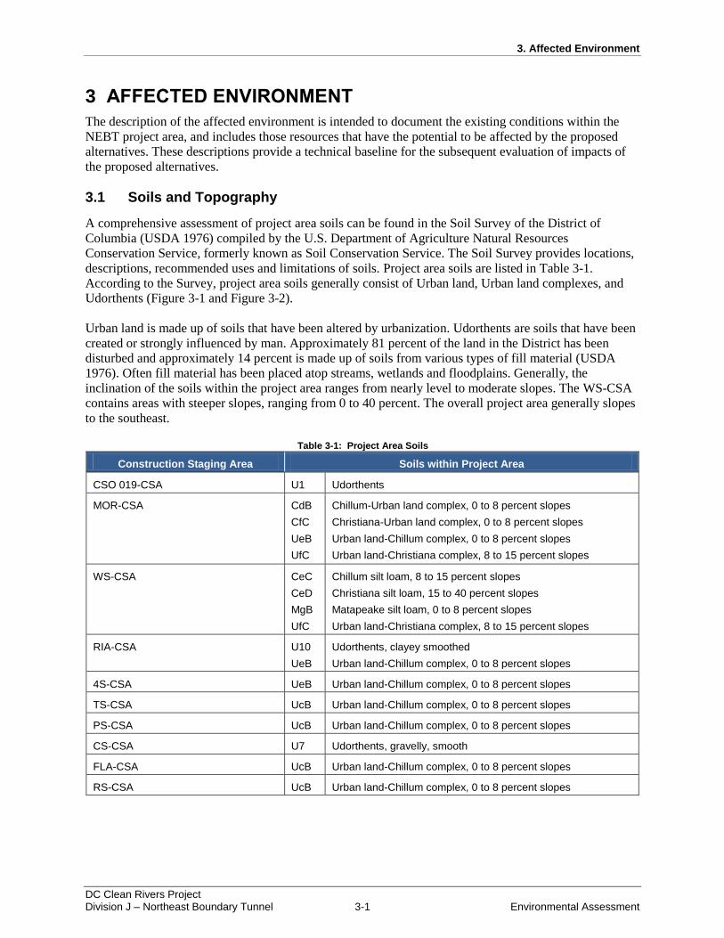
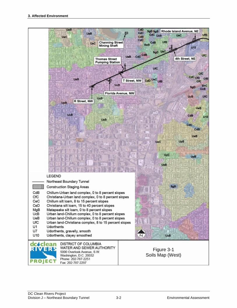
3. Affected Environment DC Clean Rivers Project Division J – Northeast Boundary Tunnel 3-1 Environmental Assessment 3 AFFECTED ENVIRONMENT The description of the affected environment is intended to document the existing conditions within the NEBT project area, and includes those resources that have the potential to be affected by the proposed alternatives. These descriptions provide a technical baseline for the subsequent evaluation of impacts of the proposed alternatives. 3.1 Soils and Topography A comprehensive assessment of project area soils can be found in the Soil Survey of the District of Columbia (USDA 1976) compiled by the U.S. Department of Agriculture Natural Resources Conservation Service, formerly known as Soil Conservation Service. The Soil Survey provides locations, descriptions, recommended uses and limitations of soils. Project area soils are listed in Table 3-1. According to the Survey, project area soils generally consist of Urban land, Urban land complexes, and Udorthents (Figure 3-1 and Figure 3-2). Urban land is made up of soils that have been altered by urbanization. Udorthents are soils that have been created or strongly influenced by man. Approximately 81 percent of the land in the District has been disturbed and approximately 14 percent is made up of soils from various types of fill material (USDA 1976). Often fill material has been placed atop streams, wetlands and floodplains. Generally, the inclination of the soils within the project area ranges from nearly level to moderate slopes. The WS-CSA contains areas with steeper slopes, ranging from 0 to 40 percent. The overall project area generally slopes to the southeast. Table 3-1: Project Area Soils Construction Staging Area Soils within Project Area CSO 019-CSA U1 Udorthents MOR-CSA CdB CfC UeB UfC Chillum-Urban land complex, 0 to 8 percent slopes Christiana-Urban land complex, 0 to 8 percent slopes Urban land-Chillum complex, 0 to 8 percent slopes Urban land-Christiana complex, 8 to 15 percent slopes WS-CSA CeC CeD MgB UfC Chillum silt loam, 8 to 15 percent slopes Christiana silt loam, 15 to 40 percent slopes Matapeake silt loam, 0 to 8 percent slopes Urban land-Christiana complex, 8 to 15 percent slopes RIA-CSA U10 UeB Udorthents, clayey smoothed Urban land-Chillum complex, 0 to 8 percent slopes 4S-CSA UeB Urban land-Chillum complex, 0 to 8 percent slopes TS-CSA UcB Urban land-Chillum complex, 0 to 8 percent slopes PS-CSA UcB Urban land-Chillum complex, 0 to 8 percent slopes CS-CSA U7 Udorthents, gravelly, smooth FLA-CSA UcB Urban land-Chillum complex, 0 to 8 percent slopes RS-CSA UcB Urban land-Chillum complex, 0 to 8 percent slopes
Transcript of 3 AFFECTED ENVIRONMENT - DC Water...3. Affected Environment DC Clean Rivers Project Division J –...
3. Affected Environment
DC Clean Rivers Project Division J – Northeast Boundary Tunnel 3-1 Environmental Assessment
3 AFFECTED ENVIRONMENT
The description of the affected environment is intended to document the existing conditions within the
NEBT project area, and includes those resources that have the potential to be affected by the proposed
alternatives. These descriptions provide a technical baseline for the subsequent evaluation of impacts of
the proposed alternatives.
3.1 Soils and Topography
A comprehensive assessment of project area soils can be found in the Soil Survey of the District of
Columbia (USDA 1976) compiled by the U.S. Department of Agriculture Natural Resources
Conservation Service, formerly known as Soil Conservation Service. The Soil Survey provides locations,
descriptions, recommended uses and limitations of soils. Project area soils are listed in Table 3-1.
According to the Survey, project area soils generally consist of Urban land, Urban land complexes, and
Udorthents (Figure 3-1 and Figure 3-2).
Urban land is made up of soils that have been altered by urbanization. Udorthents are soils that have been
created or strongly influenced by man. Approximately 81 percent of the land in the District has been
disturbed and approximately 14 percent is made up of soils from various types of fill material (USDA
1976). Often fill material has been placed atop streams, wetlands and floodplains. Generally, the
inclination of the soils within the project area ranges from nearly level to moderate slopes. The WS-CSA
contains areas with steeper slopes, ranging from 0 to 40 percent. The overall project area generally slopes
to the southeast.
Table 3-1: Project Area Soils
Construction Staging Area Soils within Project Area
CSO 019-CSA U1 Udorthents
MOR-CSA CdB
CfC
UeB
UfC
Chillum-Urban land complex, 0 to 8 percent slopes
Christiana-Urban land complex, 0 to 8 percent slopes
Urban land-Chillum complex, 0 to 8 percent slopes
Urban land-Christiana complex, 8 to 15 percent slopes
WS-CSA CeC
CeD
MgB
UfC
Chillum silt loam, 8 to 15 percent slopes
Christiana silt loam, 15 to 40 percent slopes
Matapeake silt loam, 0 to 8 percent slopes
Urban land-Christiana complex, 8 to 15 percent slopes
RIA-CSA U10
UeB
Udorthents, clayey smoothed
Urban land-Chillum complex, 0 to 8 percent slopes
4S-CSA UeB Urban land-Chillum complex, 0 to 8 percent slopes
TS-CSA UcB Urban land-Chillum complex, 0 to 8 percent slopes
PS-CSA UcB Urban land-Chillum complex, 0 to 8 percent slopes
CS-CSA U7 Udorthents, gravelly, smooth
FLA-CSA UcB Urban land-Chillum complex, 0 to 8 percent slopes
RS-CSA UcB Urban land-Chillum complex, 0 to 8 percent slopes
3. Affected Environment
DC Clean Rivers Project Division J – Northeast Boundary Tunnel 3-2 Environmental Assessment
Figure 3-1: Soils Map (West)
Figure 3-1 Soils Map (West)
3. Affected Environment
DC Clean Rivers Project Division J – Northeast Boundary Tunnel 3-3 Environmental Assessment
Figure 3-2: Soils Map (East)
Figure 3-2 Soils Map (East)

3. Affected Environment
DC Clean Rivers Project Division J – Northeast Boundary Tunnel 3-4 Environmental Assessment
Due to the variable composition of Urban land and Udorthents, recommended uses and limitations are not
designated by the Natural Resources Conservation Service. Careful examination is necessary to evaluate
the potential for any proposed uses. No soils are listed as hydric, Unique Farmland, or Soils of Statewide
Importance. Matapeake silt loam, found at the WS-CSA, is listed as prime farmland soil.
3.2 Geology and Geologic Hazards
The study area for the NEBT is within the Atlantic Coastal Plain Physiographic Province. The Atlantic
Coastal Plain is a landform region defined by sediment deposits. It extends from the Atlantic Ocean to the
Fall line, where sand and gravel give way to metamorphic rocks of the Piedmont Plateau. Sediments of
the Atlantic Coastal Plain were deposited at many different time periods and delivered by many different
processes. Formation of the region took place between 200 and 65 million years ago during the Jurassic
and Cretaceous periods, when marine sediments and alluvial materials formed a coastal shelf. During the
Quaternary period (up to 2 million years ago) sediments were deposited on the coast as a result of glacial
movements. Additional sediments have been transported to the region through river channel migration,
the filling of shallow waters, and wind-blown processes (Hanner et al., 2001).
Based on a review of United States Geologic Survey mapping (Fleming, et al., 1994), geology and
geologic hazards of the study area include the following:
Artificial fill – Artificial fill describes a heterogeneous mixture of sand, silt, clay, and gravel that
is generally the result of land development and construction activities. Fill materials are located at
the surface and may contain fragments of rock, building materials, and organic matter. Based on
the composition of fill materials and variable conditions under which the materials are placed,
artificial fill may subside over time. Local analysis of fill material is needed to determine
stability.
Middle Pleistocene deposits – middle Pleistocene deposits consist of well-bedded gravels, sands,
silts and clays of fluvial and estuarine origin. Depth to the bottom of the layer ranges from 20 to
40 feet. Although there are no hazards associated with middle Pleistocene deposits, subsidence of
materials may result where groundwater levels are lowered.
Lower Cretaceous deposits (Potomac Group) – Potomac Group sediments are located at depth
from 100 to 170 feet beneath the middle Pleistocene deposits. Sediments of the group are variable
and consist of gravels, sands, silts, and clays. Due to compression, subsidence of the layer is not a
concern. Lignite, a coal-like material formed from compression, can be found in this layer.
3.3 Groundwater and Hydrology
Grain size of the sediments, and the thickness and distribution of clay layers among the sediment helped
to produce deep water aquifers in the region. Aquifers are defined by the U.S. Geological Survey as
underground bodies of porous material, capable of supplying useful quantities of water to wells or springs
(USGS, 2002). Based on a regional analysis of hydrogeologic resources in Maryland, Delaware and the
District, there are two deep water aquifers underlying the study area: the Patuxent aquifer and the
Patapsco aquifer. Waters of the aquifers are constantly replenished by precipitation; however, the rates of
recharge vary in relation to rainfall, geology and water withdrawals.
Patuxent Aquifer
The Patuxent aquifer is the deepest of all regional aquifers (over 2,000 feet below the surface) and
contains some of the earliest sediment deposits in the Atlantic Coastal Plain region. Sediments of the
aquifer are typically medium to coarse sands or pebbly sand and gravels interbedded with thin clays.
3. Affected Environment
DC Clean Rivers Project Division J – Northeast Boundary Tunnel 3-5 Environmental Assessment
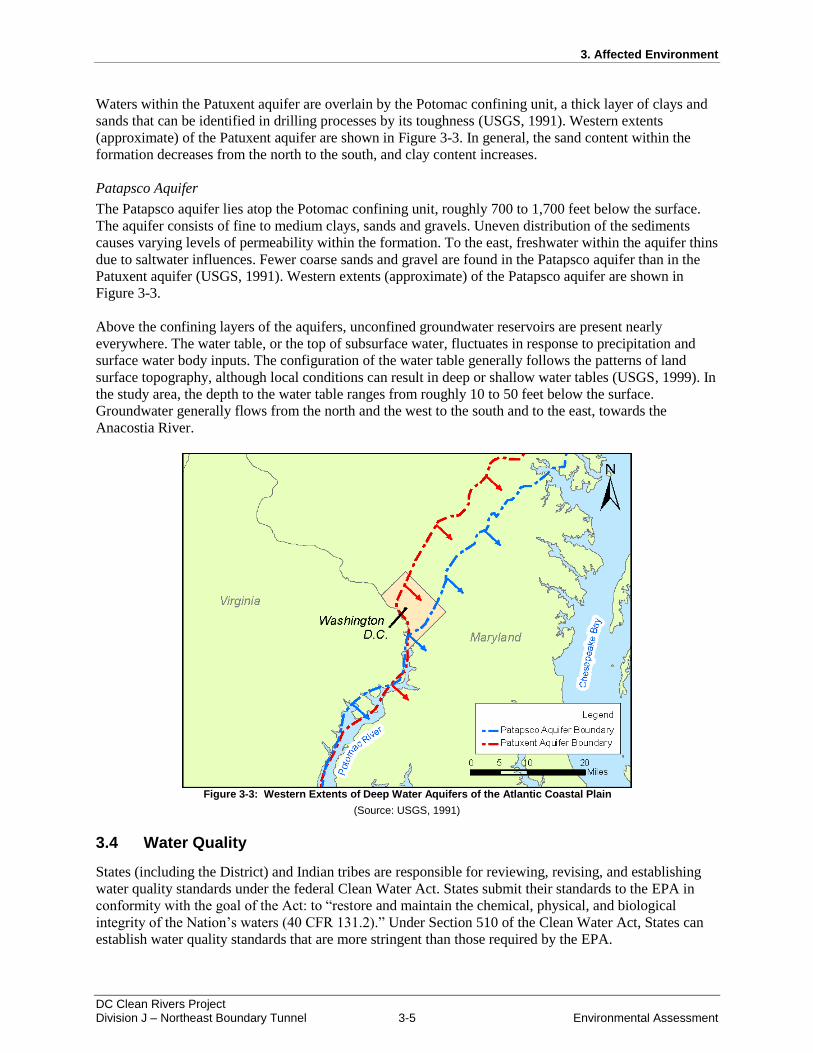
Waters within the Patuxent aquifer are overlain by the Potomac confining unit, a thick layer of clays and
sands that can be identified in drilling processes by its toughness (USGS, 1991). Western extents
(approximate) of the Patuxent aquifer are shown in Figure 3-3. In general, the sand content within the
formation decreases from the north to the south, and clay content increases.
Patapsco Aquifer
The Patapsco aquifer lies atop the Potomac confining unit, roughly 700 to 1,700 feet below the surface.
The aquifer consists of fine to medium clays, sands and gravels. Uneven distribution of the sediments
causes varying levels of permeability within the formation. To the east, freshwater within the aquifer thins
due to saltwater influences. Fewer coarse sands and gravel are found in the Patapsco aquifer than in the
Patuxent aquifer (USGS, 1991). Western extents (approximate) of the Patapsco aquifer are shown in
Figure 3-3.
Above the confining layers of the aquifers, unconfined groundwater reservoirs are present nearly
everywhere. The water table, or the top of subsurface water, fluctuates in response to precipitation and
surface water body inputs. The configuration of the water table generally follows the patterns of land
surface topography, although local conditions can result in deep or shallow water tables (USGS, 1999). In
the study area, the depth to the water table ranges from roughly 10 to 50 feet below the surface.
Groundwater generally flows from the north and the west to the south and to the east, towards the
Anacostia River.
Figure 3-3: Western Extents of Deep Water Aquifers of the Atlantic Coastal Plain
(Source: USGS, 1991)
3.4 Water Quality
States (including the District) and Indian tribes are responsible for reviewing, revising, and establishing
water quality standards under the federal Clean Water Act. States submit their standards to the EPA in
conformity with the goal of the Act: to “restore and maintain the chemical, physical, and biological
integrity of the Nation’s waters (40 CFR 131.2).” Under Section 510 of the Clean Water Act, States can
establish water quality standards that are more stringent than those required by the EPA.

3. Affected Environment
DC Clean Rivers Project Division J – Northeast Boundary Tunnel 3-6 Environmental Assessment
Water quality standards for the District were developed by the District Department of Environment Water
Quality Division. Regulations pertaining to the standards were published in 2010 under Title 21 of DC
Municipal Regulations, Chapter 11. Included in the regulations are designated use categories and use
criteria for surface waters (Table 3-2).
Table 3-2: Designated Uses of District Waters
Use Category
Designated Uses Use Criteria
A Primary Contact Recreation (i.e. swimming and direct contact)
Free of discharges of untreated sewage, litter and unmarked submerged or partially submerged man-made structures that would constitute a hazard to users.
B Secondary Contact Recreation (i.e. boating and indirect contact)
Construction, placement or mooring of facilities not primarily and directly water oriented is prohibited in, on, or over unless the facility is for the general public benefit and service, and land based alternatives are not available. Aesthetics to be maintained.
C Protection and propagation of fish, shellfish, and wildlife
Maintained to support aquatic life and not placed in pipes.
D Protection of human health related to consumption of fish and shellfish
Generally not exceeding bioconcentration factors and percent lipids in the commonly consumed fish that will result in a 10-6 human risk factor.
E Navigation Free of unmarked submerged or partially submerged man-made objects that pose a hazard to users
Source: NPS, 2010
In the District, the Anacostia River is designated for uses A, B, C, and D. Monitoring over the past 20
years has shown that pollutants in the Anacostia River regularly exceed the District’s standards for all of
these uses. As a result, the Anacostia River is listed by the District as impaired. Major causes of
impairment include biological oxygen demand (BOD), total suspended solids (TSS), pathogens, metals,
and persistent chemical pollutants called organics. The District is required to develop and implement
Total Maximum Daily Loads (TMDLs) for these pollutants, in its efforts to meet water quality standards.
In total there are TMDLs for sixteen pollutants of concern for the Anacostia River and its tributaries
(DDOE, 2012).
Stormwater and CSOs are a primary source of pollutants in the Anacostia River. CSO discharges can
adversely impact the ability of a water body to support aquatic life, as constituents of CSOs can
accumulate in the tissues of fish and shellfish. Also, contact with CSO-polluted waters or consumption of
polluted fish and shellfish can cause human health concerns. At a minimum, CSO discharges reduce the
physical appearance of surface waters and can result in unpleasant odors. In 2002, DC Water estimated
that 2,142 million gallons of CSO were discharged to the Anacostia River annually (DCWASA, 2002).
Since then, DC Water has employed techniques to reduce CSOs to the Anacostia River by approximately
40 percent and will further reduce the discharges as a result of the ARPs.
3.5 Air Quality
Air pollution was first recognized by U.S. Congress in the 1955 Air Pollution Control Act. The Act was
passed in response to nationwide concern over air quality and identified air pollution as a national crisis.
In 1963, the Clean Air Act was passed, which divided the country into regions for air monitoring.
Amendments to the Clean Air Act set national emissions standards and outlined state’s responsibilities in
improving air quality. By 1970, the Clean Air Act had been amended to set higher overall standards,
regulate the air impacts of new facilities, monitor hazardous emissions, and set standards for motor
vehicles.
3. Affected Environment
DC Clean Rivers Project Division J – Northeast Boundary Tunnel 3-7 Environmental Assessment
Clean Air Act legislation requires the EPA to provide NAAQS for air pollutants considered harmful to
public health and the environment. NAAQS for six criteria pollutants are set by the EPA. The pollutants
are nitrogen dioxide (NO2), sulfur dioxide (SO2), carbon dioxide (CO2), ozone (O3), particulate matter
equal to or less than 10 microns in size (PM10), fine particulate matter (PM2.5), and lead (Pb) (EPA, 2012).
The EPA designates areas where concentrations of criteria pollutants are below the NAAQS as being in
“attainment.” Conversely, areas where a criteria pollutant level exceeds the NAAQS are designated as
“nonattainment” by the EPA.
The Metropolitan Washington region is a nonattainment area for two of EPA’s criteria air pollutants:
ozone and PM2.5. In response to the nonattainment designation, the Metropolitan Washington Council of
Governments (MWCOG) has developed Strategic Implementation Plans to reduce ozone and PM2.5
pollution. Each of the plans provide an inventory of existing conditions, a projection of future conditions
in consideration of regional growth, and an outline of control strategies to achieve air pollutant reduction
(MWCOG, 2013).
In accordance with the Clean Air Act, the District Department of Environment is responsible for air
quality monitoring to protect public health and the environment. The District Department of Environment
carries out an EPA-approved air quality management program that includes monitoring, identifying and
implementing control strategies, assessing the results of the control strategies, and measuring progress.
Over the last 20 years, the District Department of Environment reports that criteria pollutants have
decreased significantly from historic levels due to the implementation of control measures. In the 1980s,
the introduction of vehicles equipped with the catalytic converter helped to reduce nitrogen dioxide and
carbon monoxide in the air, and the phasing out of leaded gasoline resulted in a significant drop in
airborne lead levels. Controls at stationary sources have reduced sulfur dioxide and nitrogen dioxide.
Ozone and particle pollution have also been reduced, but Metropolitan Washington remains in
nonattainment (DDOE 2012a).
In the area of the proposed NEBT, air pollution generally stems from vehicle traffic and development
activities. In particular, vehicle emissions contain volatile organic compounds (VOCs), which are a
precursor to ozone. Ozone is formed where sunlight and high temperatures cause a photochemical
reaction between VOCs and nitrogen oxides in the air. Excess nitrogen oxide in the atmosphere can result
from agricultural, industrial, or wastewater management processes, or fuel combustion.
3.6 Noise and Vibration
Portions of the project area are located in an urban residential setting that experiences background noise
and other short-lived disturbances caused by emergency vehicles and buses. Various sensitive receptors
such as residences, businesses, churches, etc., occur throughout the project area. In the District, noise
control is addressed by DC Municipal Regulations. The general provisions of noise control regulation in
DC “promote public health, safety, welfare, and the peace and quiet of the inhabitants of the District,” and
“facilitate the enjoyment of the natural attractions of the District (20 DCMR §2700.1).” Allowable limits
put forth by the regulations vary between zoning districts in DC.
Table 3-3 provides maximum permissible noise levels by zone. For construction in a Residential zone,
noise levels are measured 25 feet from the edge of the construction site. For the other zones listed in
Table 3-3, noise levels are measured at the property line of the property on which the noise originates.
During December 2013 and January 2014, ambient acoustical surveys were conducted at 12 locations
within the study area to document ambient noise levels throughout a normal 24-hour weekday and
weekend period. Additional ambient acoustical surveys will be conducted at CSAs extending into

3. Affected Environment
DC Clean Rivers Project Division J – Northeast Boundary Tunnel 3-8 Environmental Assessment
February 2014. Data was collected by placing measuring instruments on the sidewalk adjacent to
properties closest to the proposed CSAs.
During the surveys, measuring equipment collected ambient noise level data while technicians
documented noise sources. Neighborhood street background noise levels ranged from 52 dBA to 70 dBA,
which is typical for an urban environment (Gerber, 2013).
Table 3-3: Maximum Permissible Noise Levels
Zone Noise Level (decibels)
Daytime (7am to 9pm) Nighttime (9pm to 7am)
Commercial or light-manufacturing 65dB 60dB
Industrial 70dB 65dB
Residential, special purpose, or waterfront
60dB 55 dB
Construction in a Residential Zone, without variance*
80dB 55 dB
Source: 20 DCMR § 2701.1, 2802-2803
Vibrations are oscillatory motions that can be described in terms of displacement, velocity and
acceleration. For example, when a floor vibrates, the displacement is the distance that a point on the floor
moves from its static position. The velocity refers to the speed of the floor movement, and acceleration is
the rate of the change in speed. Table 3-4 presents common vibration sources and corresponding levels.
Velocity decibel notation (VdB) is used in the table to describe the magnitude of vibrations. The vibration
indicated by one velocity decibel is 1 × 10⁻⁶
inches per second.
Baseline conditions in the project area are generally free from vibrations that are above the threshold of
human perception (65 VdB or greater). DC Metrobus, Metrorail, and CSX routes are active within the
project area and may provide low level vibrations that are perceptible by project area residents.
Table 3-4: Vibration Sources and Levels
Source (within 50 feet) VdB Human/Structural Response
50
Typical background vibration →
60
Typical bus or truck → ← Approx. threshold of human perception
Typical rapid transit → 70
Typical commuter rail → ← Residential annoyance, frequent events (e.g. rapid transit)
Upper range rapid transit → 80 ← Residential annoyance, infrequent events (e.g., commuter rail)
Upper range commuter rail →
90 ← Difficulty reading a computer screen
Bulldozers and heavy tracked construction equipment →
Blasting from construction projects → 100 ← Minor cosmetic damage to fragile buildings
Source: USDOT, 2006
* Daytime limits for Construction in a Residential Zone are between 7am and 7pm, Monday through Saturday. Construction noise is not permitted on Sundays.
3. Affected Environment
DC Clean Rivers Project Division J – Northeast Boundary Tunnel 3-9 Environmental Assessment
3.7 Land Use and Zoning
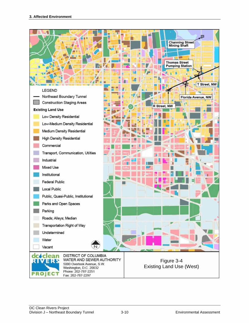
According to the District of Columbia Generalized Land Use Map, there are 19 individual land use
categories in the District. Land use categories found within the project area include commercial;
industrial; low density residential; low-medium density residential; medium density residential; parks and
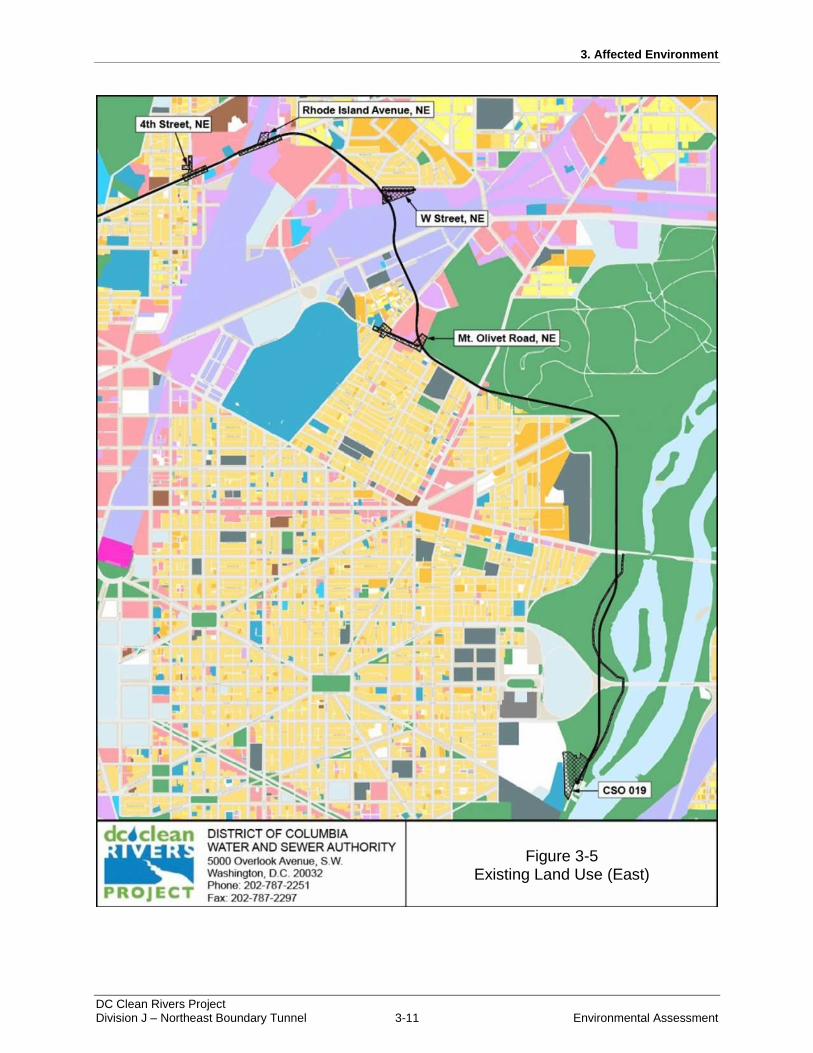
open spaces; roads, alleys, and median; and transportation, communications, and utilities. Figure 3-4 and
Figure 3-5 depict existing land use in the project area.
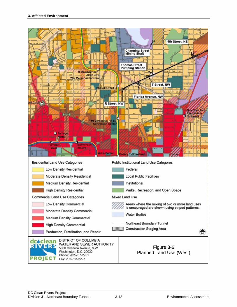
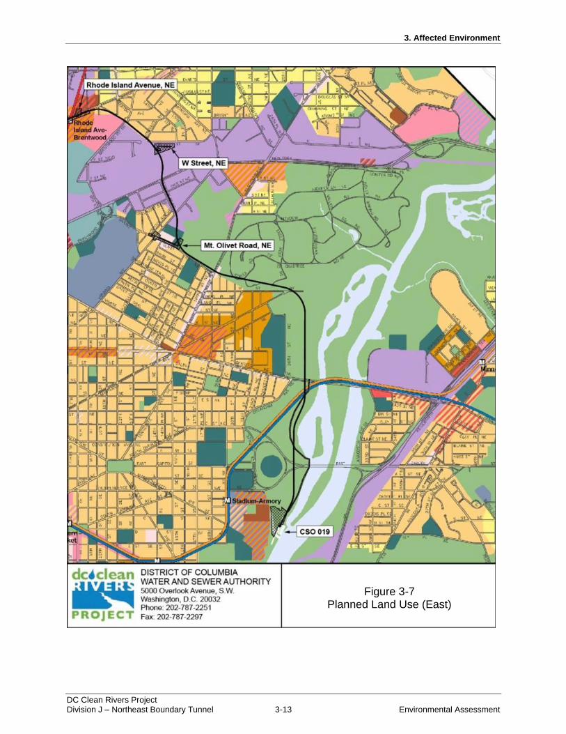
In the project area, planned land use includes parks, recreation, and open space; local public facilities;
high density and moderate density residential; production, distribution, and repair; and high density,
moderate, and low density commercial. Table 3-5 provides a summary of planned land uses and Figure
3-6 and Figure 3-7 depict planned land uses in the project area.
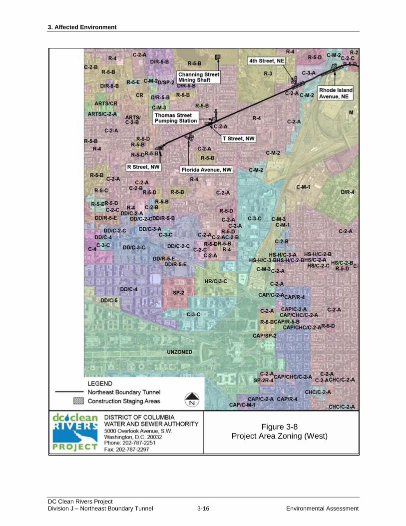
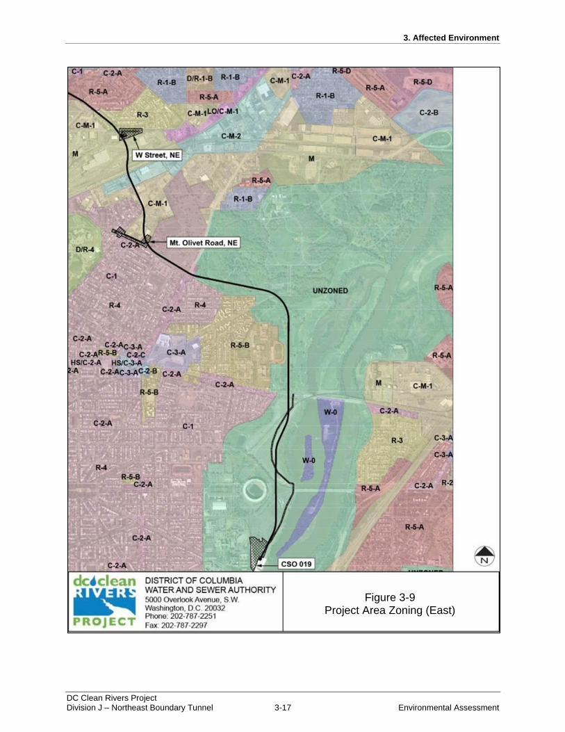
According to the District GIS Data Clearinghouse, zoning along the proposed NEBT alignment includes
four residential zones, four commercial zones, and a maintenance zone. Table 3-6 provides a summary of
the zoning districts and Figure 3-8 and Figure 3-9provide the zone boundaries in the project area.
3. Affected Environment
DC Clean Rivers Project Division J – Northeast Boundary Tunnel 3-10 Environmental Assessment
Figure 3-4: Existing Land Use (West)
Figure 3-4 Existing Land Use (West)
3. Affected Environment
DC Clean Rivers Project Division J – Northeast Boundary Tunnel 3-11 Environmental Assessment
Figure 3-5: Existing Land Use (East)
Figure 3-5 Existing Land Use (East)
3. Affected Environment
DC Clean Rivers Project Division J – Northeast Boundary Tunnel 3-12 Environmental Assessment
Figure 3-6: Planned Land Use (West)
Figure 3-6 Planned Land Use (West)
3. Affected Environment
DC Clean Rivers Project Division J – Northeast Boundary Tunnel 3-13 Environmental Assessment
Figure 3-7: Planned Land Use (East)
Figure 3-7 Planned Land Use (East)
3. Affected Environment
DC Clean Rivers Project Division J – Northeast Boundary Tunnel 3-14 Environmental Assessment
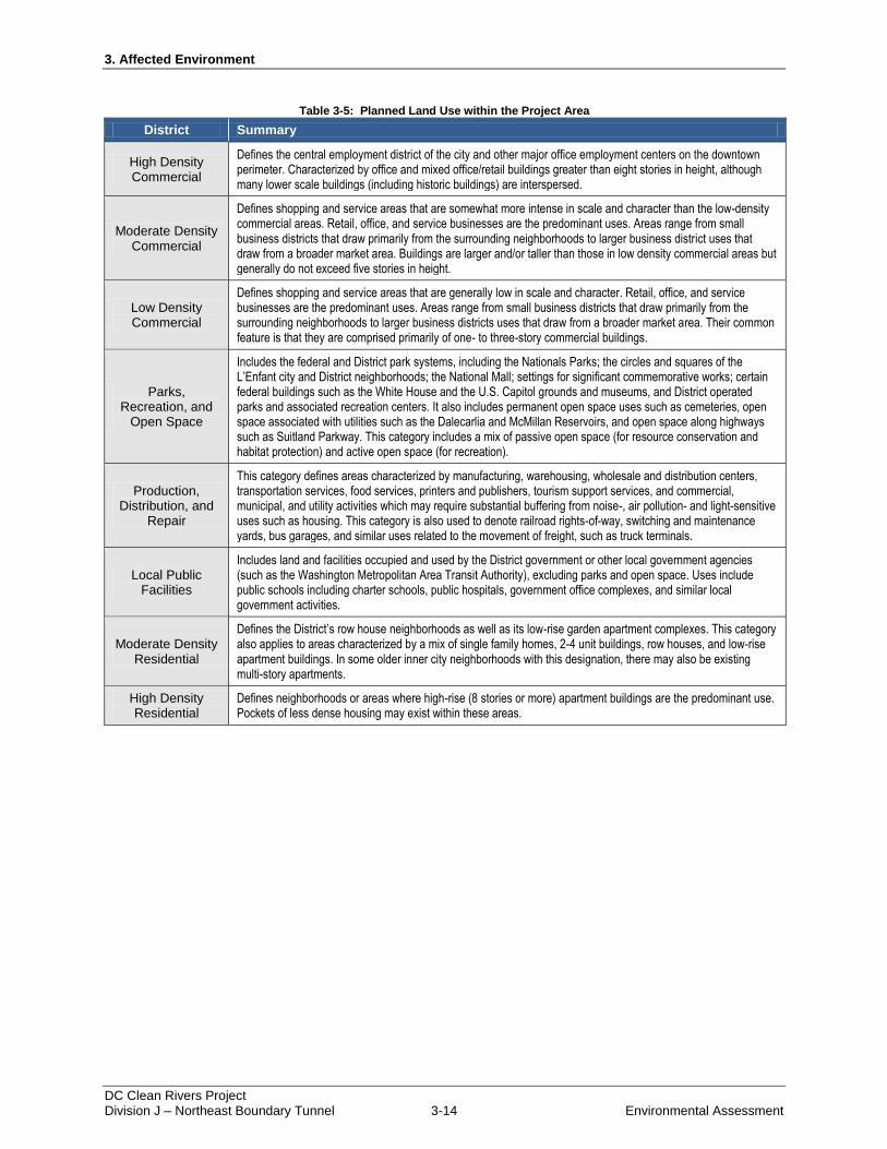
Table 3-5: Planned Land Use within the Project Area
District Summary
High Density Commercial
Defines the central employment district of the city and other major office employment centers on the downtown perimeter. Characterized by office and mixed office/retail buildings greater than eight stories in height, although many lower scale buildings (including historic buildings) are interspersed.
Moderate Density Commercial
Defines shopping and service areas that are somewhat more intense in scale and character than the low-density commercial areas. Retail, office, and service businesses are the predominant uses. Areas range from small business districts that draw primarily from the surrounding neighborhoods to larger business district uses that draw from a broader market area. Buildings are larger and/or taller than those in low density commercial areas but generally do not exceed five stories in height.
Low Density Commercial
Defines shopping and service areas that are generally low in scale and character. Retail, office, and service businesses are the predominant uses. Areas range from small business districts that draw primarily from the surrounding neighborhoods to larger business districts uses that draw from a broader market area. Their common feature is that they are comprised primarily of one- to three-story commercial buildings.
Parks, Recreation, and
Open Space
Includes the federal and District park systems, including the Nationals Parks; the circles and squares of the L’Enfant city and District neighborhoods; the National Mall; settings for significant commemorative works; certain federal buildings such as the White House and the U.S. Capitol grounds and museums, and District operated parks and associated recreation centers. It also includes permanent open space uses such as cemeteries, open space associated with utilities such as the Dalecarlia and McMillan Reservoirs, and open space along highways such as Suitland Parkway. This category includes a mix of passive open space (for resource conservation and habitat protection) and active open space (for recreation).
Production, Distribution, and
Repair
This category defines areas characterized by manufacturing, warehousing, wholesale and distribution centers, transportation services, food services, printers and publishers, tourism support services, and commercial, municipal, and utility activities which may require substantial buffering from noise-, air pollution- and light-sensitive uses such as housing. This category is also used to denote railroad rights-of-way, switching and maintenance yards, bus garages, and similar uses related to the movement of freight, such as truck terminals.
Local Public Facilities
Includes land and facilities occupied and used by the District government or other local government agencies (such as the Washington Metropolitan Area Transit Authority), excluding parks and open space. Uses include public schools including charter schools, public hospitals, government office complexes, and similar local government activities.
Moderate Density Residential
Defines the District’s row house neighborhoods as well as its low-rise garden apartment complexes. This category also applies to areas characterized by a mix of single family homes, 2-4 unit buildings, row houses, and low-rise apartment buildings. In some older inner city neighborhoods with this designation, there may also be existing multi-story apartments.
High Density Residential
Defines neighborhoods or areas where high-rise (8 stories or more) apartment buildings are the predominant use. Pockets of less dense housing may exist within these areas.
3. Affected Environment
DC Clean Rivers Project Division J – Northeast Boundary Tunnel 3-15 Environmental Assessment
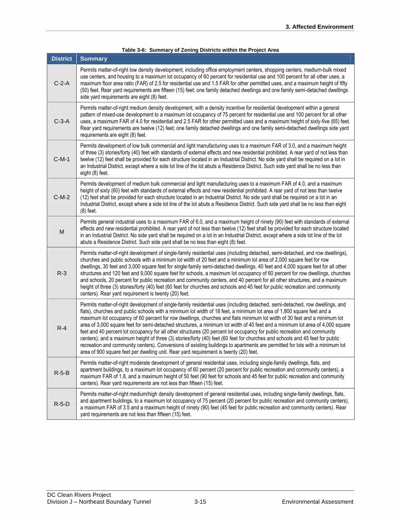
Table 3-6: Summary of Zoning Districts within the Project Area
District Summary
C-2-A
Permits matter-of-right low density development, including office employment centers, shopping centers, medium-bulk mixed use centers, and housing to a maximum lot occupancy of 60 percent for residential use and 100 percent for all other uses, a maximum floor area ratio (FAR) of 2.5 for residential use and 1.5 FAR for other permitted uses, and a maximum height of fifty (50) feet. Rear yard requirements are fifteen (15) feet; one family detached dwellings and one family semi-detached dwellings side yard requirements are eight (8) feet.
C-3-A
Permits matter-of-right medium density development, with a density incentive for residential development within a general pattern of mixed-use development to a maximum lot occupancy of 75 percent for residential use and 100 percent for all other uses, a maximum FAR of 4.0 for residential and 2.5 FAR for other permitted uses and a maximum height of sixty-five (65) feet. Rear yard requirements are twelve (12) feet; one family detached dwellings and one family semi-detached dwellings side yard requirements are eight (8) feet.
C-M-1
Permits development of low bulk commercial and light manufacturing uses to a maximum FAR of 3.0, and a maximum height of three (3) stories/forty (40) feet with standards of external effects and new residential prohibited. A rear yard of not less than twelve (12) feet shall be provided for each structure located in an Industrial District. No side yard shall be required on a lot in an Industrial District, except where a side lot line of the lot abuts a Residence District. Such side yard shall be no less than eight (8) feet.
C-M-2
Permits development of medium bulk commercial and light manufacturing uses to a maximum FAR of 4.0, and a maximum height of sixty (60) feet with standards of external effects and new residential prohibited. A rear yard of not less than twelve (12) feet shall be provided for each structure located in an Industrial District. No side yard shall be required on a lot in an Industrial District, except where a side lot line of the lot abuts a Residence District. Such side yard shall be no less than eight (8) feet.
M
Permits general industrial uses to a maximum FAR of 6.0, and a maximum height of ninety (90) feet with standards of external effects and new residential prohibited. A rear yard of not less than twelve (12) feet shall be provided for each structure located in an Industrial District. No side yard shall be required on a lot in an Industrial District, except where a side lot line of the lot abuts a Residence District. Such side yard shall be no less than eight (8) feet.
R-3
Permits matter-of-right development of single-family residential uses (including detached, semi-detached, and row dwellings), churches and public schools with a minimum lot width of 20 feet and a minimum lot area of 2,000 square feet for row dwellings, 30 feet and 3,000 square feet for single-family semi-detached dwellings, 40 feet and 4,000 square feet for all other structures and 120 feet and 9,000 square feet for schools, a maximum lot occupancy of 60 percent for row dwellings, churches and schools, 20 percent for public recreation and community centers, and 40 percent for all other structures, and a maximum height of three (3) stories/forty (40) feet (60 feet for churches and schools and 45 feet for public recreation and community centers). Rear yard requirement is twenty (20) feet.
R-4
Permits matter-of-right development of single-family residential uses (including detached, semi-detached, row dwellings, and flats), churches and public schools with a minimum lot width of 18 feet, a minimum lot area of 1,800 square feet and a maximum lot occupancy of 60 percent for row dwellings, churches and flats minimum lot width of 30 feet and a minimum lot area of 3,000 square feet for semi-detached structures, a minimum lot width of 40 feet and a minimum lot area of 4,000 square feet and 40 percent lot occupancy for all other structures (20 percent lot occupancy for public recreation and community centers); and a maximum height of three (3) stories/forty (40) feet (60 feet for churches and schools and 45 feet for public recreation and community centers). Conversions of existing buildings to apartments are permitted for lots with a minimum lot area of 900 square feet per dwelling unit. Rear yard requirement is twenty (20) feet.
R-5-B
Permits matter-of-right moderate development of general residential uses, including single-family dwellings, flats, and apartment buildings, to a maximum lot occupancy of 60 percent (20 percent for public recreation and community centers), a maximum FAR of 1.8, and a maximum height of 50 feet (90 feet for schools and 45 feet for public recreation and community centers). Rear yard requirements are not less than fifteen (15) feet.
R-5-D
Permits matter-of-right medium/high density development of general residential uses, including single-family dwellings, flats, and apartment buildings, to a maximum lot occupancy of 75 percent (20 percent for public recreation and community centers), a maximum FAR of 3.5 and a maximum height of ninety (90) feet (45 feet for public recreation and community centers). Rear yard requirements are not less than fifteen (15) feet.
3. Affected Environment
DC Clean Rivers Project Division J – Northeast Boundary Tunnel 3-16 Environmental Assessment
Figure 3-8: Project Area Zoning (West)
Figure 3-8 Project Area Zoning (West)
3. Affected Environment
DC Clean Rivers Project Division J – Northeast Boundary Tunnel 3-17 Environmental Assessment
Figure 3-9: Project Area Zoning (East)
Figure 3-9 Project Area Zoning (East)
3. Affected Environment
DC Clean Rivers Project Division J – Northeast Boundary Tunnel 3-18 Environmental Assessment
3.8 Utilities/Infrastructure
Additional infrastructural elements in the project area include underground water supply, gas,
communication, and electric lines. Potable water in the area is supplied by DC Water. Gas utilities in the
area are maintained by Washington Gas, communication lines are maintained by Verizon and Comcast,
and electric utilities in the area are maintained by the Potomac Electric Power Company (Pepco).
3.9 Cultural/Historic Resources
This section describes the cultural resources present at the project sites and in the surrounding area. This
information is derived from National Register nominations, National Historic Landmarks (NHL)
documentation, the DC Inventory, historic maps, site reconnaissance, and other archival materials.
The NHPA of 1966, as amended, is the guiding legislation for the preservation of historic properties. As
broadly defined by 36 CFR § 800, historic properties are “any prehistoric or historic district, site,
building, structure, or object included in, or eligible for inclusion in the National Register of Historic
Places.” The formal DC Historic Preservation Review process requires that Federal agencies take into
account the effects of their actions on properties listed, or eligible for listing, in the NRHP.
As the lead agency, DC Water has begun the initial steps to enter into consultation with the DC Historic
Preservation Office and other interested agencies and individuals to identify historic properties that could
be affected, to assess potential adverse effects, and to resolve the adverse effects through mutually agreed
upon avoidance, minimization, or mitigation measures. To begin this process, a preliminary determination
of the area of potential effect was completed. The area of potential effect, as defined by 36 CFR § 800,
16(d), represents “the geographic area within which an undertaking may directly or indirectly cause
alterations in the character or use of historic properties, if any such properties exist.”
The preliminary area of potential effect for historic resources accounts for the potential for one or both of
the Alternatives to physically or visually affect historic landmarks, districts, parks, or other historic
resources. The area of potential effect includes the footprint of these facility elements and associated
construction disturbance or staging areas, and expands from the center line of the proposed tunnel,
including the zone of influence for tunnel and diversion construction, which can be seen in Appendix A.
3.9.1 Historic Resources
The proposed NEBT corridor would be located near a number of historic resources. Located in northwest
and northeast Washington, DC, the proposed NEBT is sited within Washington’s industrial corridor
running along New York Avenue and Rhode Island Avenue. The project area also runs immediately
adjacent to and through historic districts. The location of historic resources within or adjacent to the study
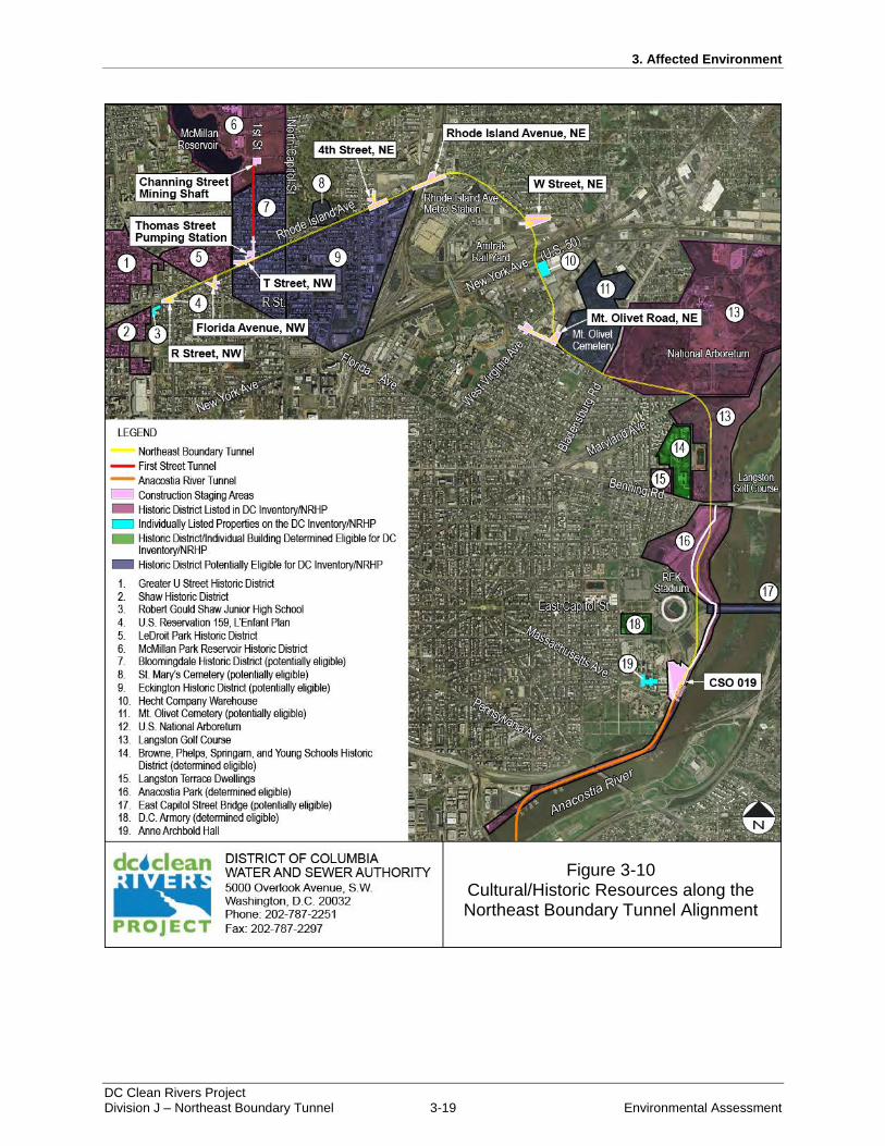
area can be found in Figure 3-10 followed by descriptions of each of the resources.
3. Affected Environment
DC Clean Rivers Project Division J – Northeast Boundary Tunnel 3-19 Environmental Assessment
Figure 3-10: Cultural/Historic Resources along the Northeast Boundary Tunnel Alignment
Figure 3-10 Cultural/Historic Resources along the Northeast Boundary Tunnel Alignment
3. Affected Environment
DC Clean Rivers Project Division J – Northeast Boundary Tunnel 3-20 Environmental Assessment
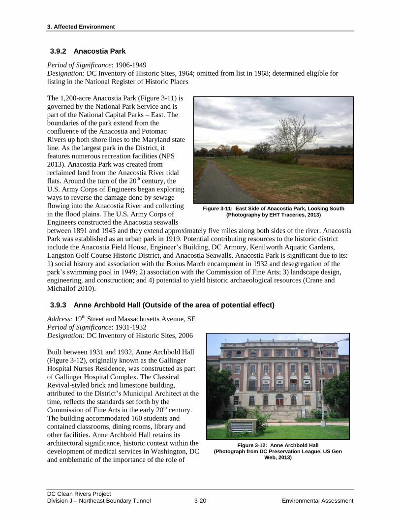
3.9.2 Anacostia Park
Period of Significance: 1906-1949
Designation: DC Inventory of Historic Sites, 1964; omitted from list in 1968; determined eligible for
listing in the National Register of Historic Places
The 1,200-acre Anacostia Park (Figure 3-11) is
governed by the National Park Service and is
part of the National Capital Parks – East. The
boundaries of the park extend from the
confluence of the Anacostia and Potomac
Rivers up both shore lines to the Maryland state
line. As the largest park in the District, it
features numerous recreation facilities (NPS
2013). Anacostia Park was created from
reclaimed land from the Anacostia River tidal
flats. Around the turn of the 20th century, the
U.S. Army Corps of Engineers began exploring
ways to reverse the damage done by sewage
flowing into the Anacostia River and collecting
in the flood plains. The U.S. Army Corps of
Engineers constructed the Anacostia seawalls
between 1891 and 1945 and they extend approximately five miles along both sides of the river. Anacostia
Park was established as an urban park in 1919. Potential contributing resources to the historic district
include the Anacostia Field House, Engineer’s Building, DC Armory, Kenilworth Aquatic Gardens,
Langston Golf Course Historic District, and Anacostia Seawalls. Anacostia Park is significant due to its:
1) social history and association with the Bonus March encampment in 1932 and desegregation of the
park’s swimming pool in 1949; 2) association with the Commission of Fine Arts; 3) landscape design,
engineering, and construction; and 4) potential to yield historic archaeological resources (Crane and
Michailof 2010).
3.9.3 Anne Archbold Hall (Outside of the area of potential effect)
Address: 19th Street and Massachusetts Avenue, SE
Period of Significance: 1931-1932
Designation: DC Inventory of Historic Sites, 2006
Built between 1931 and 1932, Anne Archbold Hall
(Figure 3-12), originally known as the Gallinger
Hospital Nurses Residence, was constructed as part
of Gallinger Hospital Complex. The Classical
Revival-styled brick and limestone building,
attributed to the District’s Municipal Architect at the
time, reflects the standards set forth by the
Commission of Fine Arts in the early 20th century.
The building accommodated 160 students and
contained classrooms, dining rooms, library and
other facilities. Anne Archbold Hall retains its
architectural significance, historic context within the
development of medical services in Washington, DC
and emblematic of the importance of the role of
Figure 3-11: East Side of Anacostia Park, Looking South
(Photography by EHT Traceries, 2013)
Figure 3-12: Anne Archbold Hall (Photograph from DC Preservation League, US Gen
Web, 2013)
3. Affected Environment
DC Clean Rivers Project Division J – Northeast Boundary Tunnel 3-21 Environmental Assessment
Figure 3-13: 100 Block of Randolph Place, a Typical Street in the Bloomingdale Neighborhood
(Photography by EHT Traceries, 2013)
nurses within the entire complex as it moved from being a largely religious service to a respected medical
profession. The building was dedicated to Anne Archbold in 1945 (DC HPO 2009).
3.9.4 Bloomingdale Historic District
Period of Significance: 1892-1906
Designation: Potentially eligible for listing in the DC Inventory of Historic Sites and National Register of
Historic Places
Bounded by R Street, North Capitol Street, Bryant Street, and 2nd
Street, NW, Bloomingdale originated
from several 19th century estates. Towards the end of the century, however, the primarily rural land and
light industrial area was subdivided due to an increase of population in Washington, DC and the creation
of the streetcar system that allowed the middle-class to live farther from their places of business.
Developers William Shannon and Ray E. Middaugh, who formed the firm Shannon & Middaugh,
initiated the improvement of Bloomingdale with the construction of row houses. From 1900 to 1901,
architect B. Stanley Simmons designed forty-seven of these row houses for Middaugh & Shannon.
Beginning in 1902; however, the firm relied exclusively on Joseph Bohn, Jr. as its architect. Washington
Post’s 1903 History of the City of Washington reported that, as a result of Middaugh & Shannon’s initial
development in the neighborhood, there were 869 houses, accommodating 3,484 people. A complete row
located on Randolph Place between 1st and 2
nd Streets, NW can be seen in Figure 3-13.
Other developers including Harry Wardman, Francis Blundon, and S.H. Meyers built a multitude of row
house dwellings in the neighborhood. In an attempt to meet housing demands and maintain low costs,
Wardman pioneered a style of row houses that divided the building into two identical apartment units
within one row house. Called
“row house flats,” the housing
type never became popular in the
District, but a number of
examples remain in the
Bloomingdale area. The
neighborhood is significant for its
development within the context
of Washington, DC and
architectural cohesiveness as a
representation of Queen Anne,
Richardsonian Romanesque, and
Colonial Revival styled row
house dwellings. Notable
individual buildings include Mt.
Bethel Baptist Church (formerly
Central Methodist Protestant
Church) designed by architect
James E. Denson in 1902 (DC
Water 2012).
3.9.5 Browne, Phelps, Spingarn, and Young Schools Historic District (Outside of the
area of potential effect)
Period of Significance: 1929-1952
Designation: Determined eligible for listing in the DC Inventory of Historic Sites
3. Affected Environment
DC Clean Rivers Project Division J – Northeast Boundary Tunnel 3-22 Environmental Assessment
Browne, Phelps, Spingarn, and Young Schools Historic District includes four public schools built for
African-American students between 1929 and 1952. Originally referred to as Education Hill, the schools
were built to accommodate the growing population in Langston/Carver and Kingman Park.
The Colonial Revival style Charles Young Elementary School was the first building to be built on the
campus after the District Board of Education purchased 42.5 acres of land on Benning Street, NE in 1929.
Built in 1931, the school was named for Charles E. Young, one of the first African-American graduates of
West Point, decorated officer, and the first African-American National Park Service superintendent.
The second building on campus, constructed between 1931 and 1932, was Hugh M. Browne Junior High
School. Designed by architect S.B. Walsh, the Colonial Revival building is located on the north end of
campus facing the Anacostia River. The school was named for Hugh M. Browne, a prominent, local
African-American educator, minister, and civil rights activist.
The Seth Ledyard Phelps Vocational School, formerly Phelps Career High School, was constructed
between 1932 and 1934, as a technical training school for African Americans. Designed by the Office of
the Municipal Architect in the Colonial Revival style, the school was named for Seth Ledyard Phelps, an
African-American naval officer and diplomat. After being closed in 2002 due to lack of enrollment, the
building was renovated in 2008 and reopened as the Phelps Architecture, Construction, and Engineering
High School.
Located on the southern end of campus, the Joel Elias Spingarn High School was constructed between
1950 and 1952, also in the Colonial Revival style. The building was dedicated to Joel Elias Spingarn who
served as both chairman and president of the National Association for the Advancement of Colored
People.
The campus is significant for being the first and only planned public educational campus in the District,
an example of the evolution of public education for African-Americans, segregation, desegregation, and
integration, the development of Washington neighborhoods, and for being excellent examples of Colonial
Revival architecture, reflecting the evolution of public school architecture in the District (Barnes 2013).
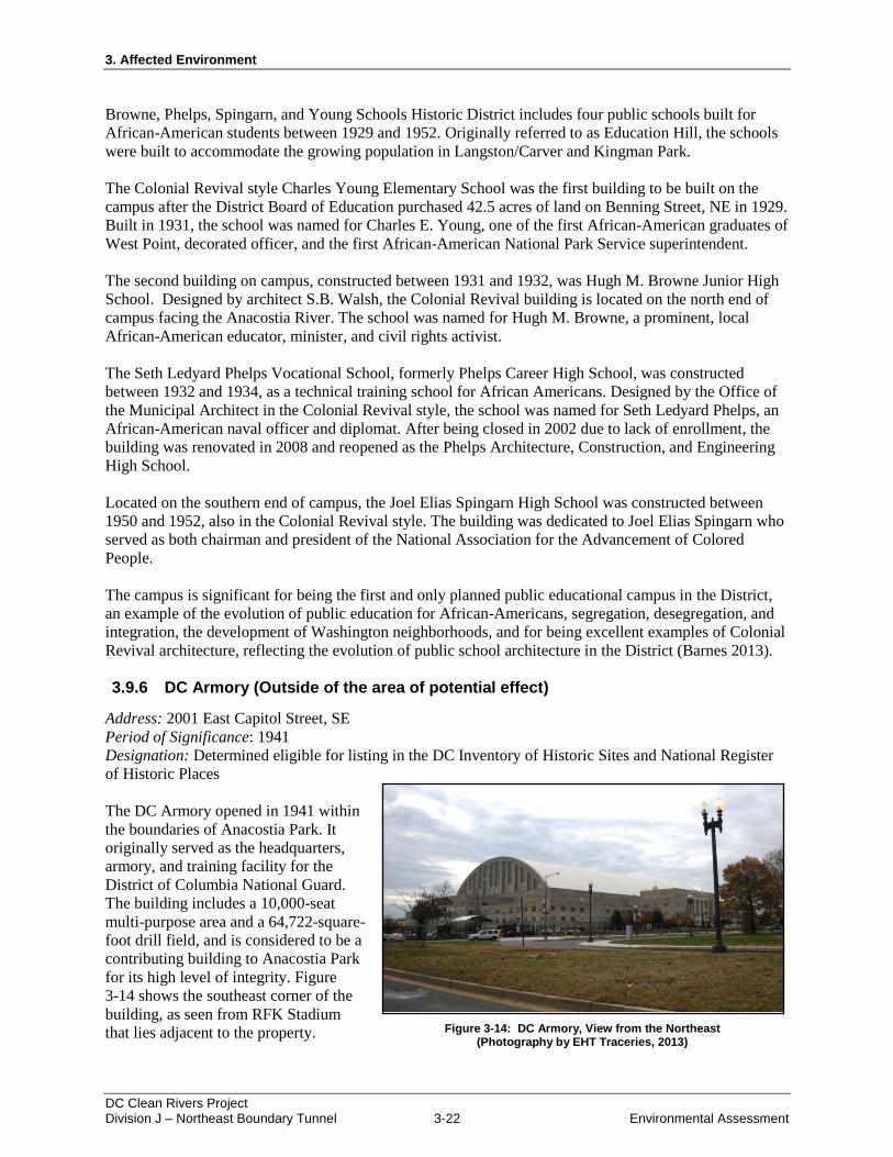
3.9.6 DC Armory (Outside of the area of potential effect)
Address: 2001 East Capitol Street, SE
Period of Significance: 1941
Designation: Determined eligible for listing in the DC Inventory of Historic Sites and National Register
of Historic Places
The DC Armory opened in 1941 within
the boundaries of Anacostia Park. It
originally served as the headquarters,
armory, and training facility for the
District of Columbia National Guard.
The building includes a 10,000-seat
multi-purpose area and a 64,722-square-
foot drill field, and is considered to be a
contributing building to Anacostia Park
for its high level of integrity. Figure
3-14 shows the southeast corner of the
building, as seen from RFK Stadium
that lies adjacent to the property. Figure 3-14: DC Armory, View from the Northeast (Photography by EHT Traceries, 2013)
3. Affected Environment
DC Clean Rivers Project Division J – Northeast Boundary Tunnel 3-23 Environmental Assessment
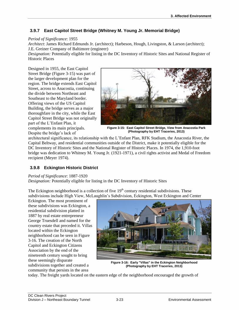
3.9.7 East Capitol Street Bridge (Whitney M. Young Jr. Memorial Bridge)
Period of Significance: 1955
Architect: James Richard Edmunds Jr. (architect); Harbeson, Hough, Livingston, & Larson (architect);
J.E. Greiner Company of Baltimore (engineer)
Designation: Potentially eligible for listing in the DC Inventory of Historic Sites and National Register of
Historic Places
Designed in 1955, the East Capitol
Street Bridge (Figure 3-15) was part of
the larger development plan for the
region. The bridge extends East Capitol
Street, across to Anacostia, continuing
the divide between Northeast and
Southeast to the Maryland border.
Offering views of the US Capitol
Building, the bridge serves as a major
thoroughfare in the city, while the East
Capitol Street Bridge was not originally
part of the L’Enfant Plan, it
complements its main principals.
Despite the bridge’s lack of
architectural significance, its relationship with the L’Enfant Plan, RFK Stadium, the Anacostia River, the
Capital Beltway, and residential communities outside of the District, make it potentially eligible for the
DC Inventory of Historic Sites and the National Register of Historic Places. In 1974, the 1,910-foot
bridge was dedication to Whitney M. Young Jr. (1921-1971), a civil rights activist and Medal of Freedom
recipient (Meyer 1974).
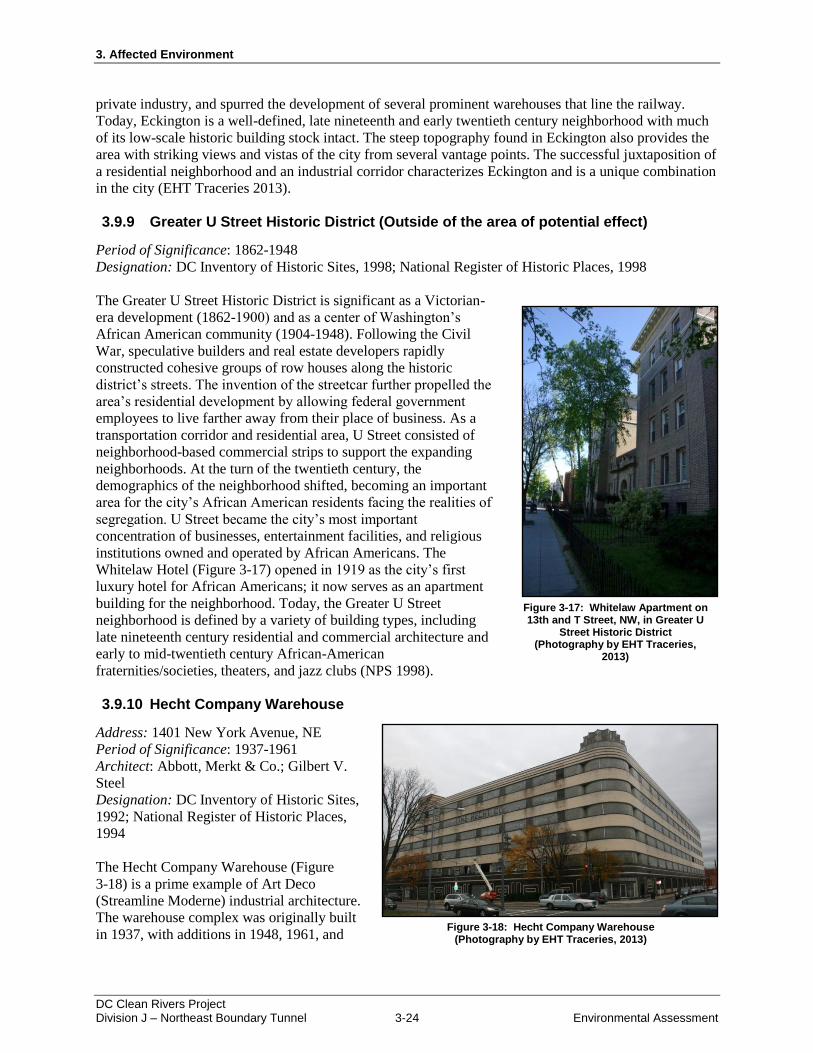
3.9.8 Eckington Historic District
Period of Significance: 1887-1920
Designation: Potentially eligible for listing in the DC Inventory of Historic Sites
The Eckington neighborhood is a collection of five 19th century residential subdivisions. These
subdivisions include High View, McLaughlin’s Subdivision, Eckington, West Eckington and Center
Eckington. The most prominent of
these subdivisions was Eckington, a
residential subdivision platted in
1887 by real estate entrepreneur
George Truesdell and named for the
country estate that preceded it. Villas
located within the Eckington
neighborhood can be seen in Figure
3-16. The creation of the North
Capitol and Eckington Citizens
Association by the end of the
nineteenth century sought to bring
these seemingly disparate
subdivisions together and created a
community that persists in the area
today. The freight yards located on the eastern edge of the neighborhood encouraged the growth of
Figure 3-16: Early "Villas" in the Eckington Neighborhood (Photography by EHT Traceries, 2013)
Figure 3-15: East Capitol Street Bridge, View from Anacostia Park (Photography by EHT Traceries, 2013)
3. Affected Environment
DC Clean Rivers Project Division J – Northeast Boundary Tunnel 3-24 Environmental Assessment
private industry, and spurred the development of several prominent warehouses that line the railway.
Today, Eckington is a well-defined, late nineteenth and early twentieth century neighborhood with much
of its low-scale historic building stock intact. The steep topography found in Eckington also provides the
area with striking views and vistas of the city from several vantage points. The successful juxtaposition of
a residential neighborhood and an industrial corridor characterizes Eckington and is a unique combination
in the city (EHT Traceries 2013).
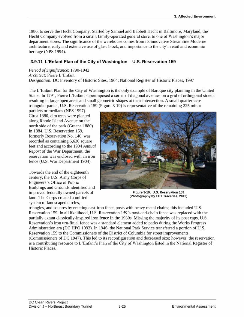
3.9.9 Greater U Street Historic District (Outside of the area of potential effect)
Period of Significance: 1862-1948
Designation: DC Inventory of Historic Sites, 1998; National Register of Historic Places, 1998
The Greater U Street Historic District is significant as a Victorian-
era development (1862-1900) and as a center of Washington’s
African American community (1904-1948). Following the Civil
War, speculative builders and real estate developers rapidly
constructed cohesive groups of row houses along the historic
district’s streets. The invention of the streetcar further propelled the
area’s residential development by allowing federal government
employees to live farther away from their place of business. As a
transportation corridor and residential area, U Street consisted of
neighborhood-based commercial strips to support the expanding
neighborhoods. At the turn of the twentieth century, the
demographics of the neighborhood shifted, becoming an important
area for the city’s African American residents facing the realities of
segregation. U Street became the city’s most important
concentration of businesses, entertainment facilities, and religious
institutions owned and operated by African Americans. The
Whitelaw Hotel (Figure 3-17) opened in 1919 as the city’s first
luxury hotel for African Americans; it now serves as an apartment
building for the neighborhood. Today, the Greater U Street
neighborhood is defined by a variety of building types, including
late nineteenth century residential and commercial architecture and
early to mid-twentieth century African-American
fraternities/societies, theaters, and jazz clubs (NPS 1998).
3.9.10 Hecht Company Warehouse
Address: 1401 New York Avenue, NE
Period of Significance: 1937-1961
Architect: Abbott, Merkt & Co.; Gilbert V.
Steel
Designation: DC Inventory of Historic Sites,
1992; National Register of Historic Places,
1994
The Hecht Company Warehouse (Figure
3-18) is a prime example of Art Deco
(Streamline Moderne) industrial architecture.
The warehouse complex was originally built
in 1937, with additions in 1948, 1961, and
Figure 3-17: Whitelaw Apartment on 13th and T Street, NW, in Greater U
Street Historic District (Photography by EHT Traceries,
2013)
Figure 3-18: Hecht Company Warehouse (Photography by EHT Traceries, 2013)
3. Affected Environment
DC Clean Rivers Project Division J – Northeast Boundary Tunnel 3-25 Environmental Assessment
1986, to serve the Hecht Company. Started by Samuel and Babbett Hecht in Baltimore, Maryland, the
Hecht Company evolved from a small, family-operated general store, to one of Washington’s major
department stores. The significance of the warehouse comes from its innovative Streamline Moderne
architecture, early and extensive use of glass block, and importance to the city’s retail and economic
heritage (NPS 1994).
3.9.11 L’Enfant Plan of the City of Washington – U.S. Reservation 159
Period of Significance: 1790-1942
Architect: Pierre L’Enfant
Designation: DC Inventory of Historic Sites, 1964; National Register of Historic Places, 1997
The L’Enfant Plan for the City of Washington is the only example of Baroque city planning in the United
States. In 1791, Pierre L’Enfant superimposed a series of diagonal avenues on a grid of orthogonal streets
resulting in large open areas and small geometric shapes at their intersection. A small quarter-acre
triangular parcel, U.S. Reservation 159 (Figure 3-19) is representative of the remaining 225 minor
parklets or medians (NPS 1997).
Circa 1880, elm trees were planted
along Rhode Island Avenue on the
north side of the park (Greene 1880).
In 1884, U.S. Reservation 159,
formerly Reservation No. 140, was
recorded as containing 6,630 square
feet and according to the 1904 Annual
Report of the War Department, the
reservation was enclosed with an iron
fence (U.S. War Department 1904).
Towards the end of the eighteenth
century, the U.S. Army Corps of
Engineers’s Office of Public
Buildings and Grounds identified and
improved federally owned parcels of
land. The Corps created a unified
system of landscaped circles,
triangles, and squares by erecting cast-iron fence posts with heavy metal chains; this included U.S.
Reservation 159. In all likelihood, U.S. Reservation 159’s post-and-chain fence was replaced with the
partially extant classically-inspired iron fence in the 1930s. Missing the majority of its post caps, U.S.
Reservation’s iron urn-finial fence was a standard element added to parks during the Works Progress
Administration era (DC HPO 1993). In 1946, the National Park Service transferred a portion of U.S.
Reservation 159 to the Commissioners of the District of Columbia for street improvements
(Commissioners of DC 1947). This led to its reconfiguration and decreased size; however, the reservation
is a contributing resource to L’Enfant’s Plan of the City of Washington listed in the National Register of
Historic Places.
Figure 3-19: U.S. Reservation 159
(Photography by EHT Traceries, 2013)
3. Affected Environment
DC Clean Rivers Project Division J – Northeast Boundary Tunnel 3-26 Environmental Assessment
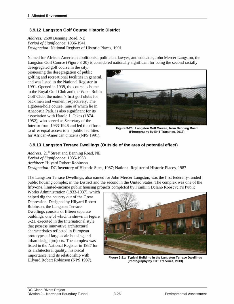
3.9.12 Langston Golf Course Historic District
Address: 2600 Benning Road, NE
Period of Significance: 1936-1941
Designation: National Register of Historic Places, 1991
Named for African-American abolitionist, politician, lawyer, and educator, John Mercer Langston, the
Langston Golf Course (Figure 3-20) is considered nationally significant for being the second racially
desegregated golf course in the city,
pioneering the desegregation of public
golfing and recreational facilities in general,
and was listed in the National Register in
1991. Opened in 1939, the course is home
to the Royal Golf Club and the Wake Robin
Golf Club, the nation’s first golf clubs for
back men and women, respectively. The
eighteen-hole course, nine of which lie in
Anacostia Park, is also significant for its
association with Harold L. Ickes (1874-
1952), who served as Secretary of the
Interior from 1933-1946 and led the efforts
to offer equal access to all public facilities
for African-American citizens (NPS 1991).
3.9.13 Langston Terrace Dwellings (Outside of the area of potential effect)
Address: 21st Street and Benning Road, NE
Period of Significance: 1935-1938
Architect: Hilyard Robert Robinson
Designation: DC Inventory of Historic Sites, 1987; National Register of Historic Places, 1987
The Langston Terrace Dwellings, also named for John Mercer Langston, was the first federally-funded
public housing complex in the District and the second in the United States. The complex was one of the
fifty-one, limited-income public housing projects completed by Franklin Delano Roosevelt’s Public
Works Administration (1933-1937), which
helped dig the country out of the Great
Depression. Designed by Hilyard Robert
Robinson, the Langston Terrace
Dwellings consists of fifteen separate
buildings, one of which is shown in Figure
3-21, executed in the International style
that possess innovative architectural
characteristics reflected in European
prototypes of large-scale housing and
urban-design projects. The complex was
listed in the National Register in 1987 for
its architectural quality, historical
importance, and its relationship with
Hilyard Robert Robinson (NPS 1987).
Figure 3-20: Langston Golf Course, from Benning Road (Photography by EHT Traceries, 2013)
Figure 3-21: Typical Building in the Langston Terrace Dwellings (Photography by EHT Traceries, 2013)
3. Affected Environment
DC Clean Rivers Project Division J – Northeast Boundary Tunnel 3-27 Environmental Assessment
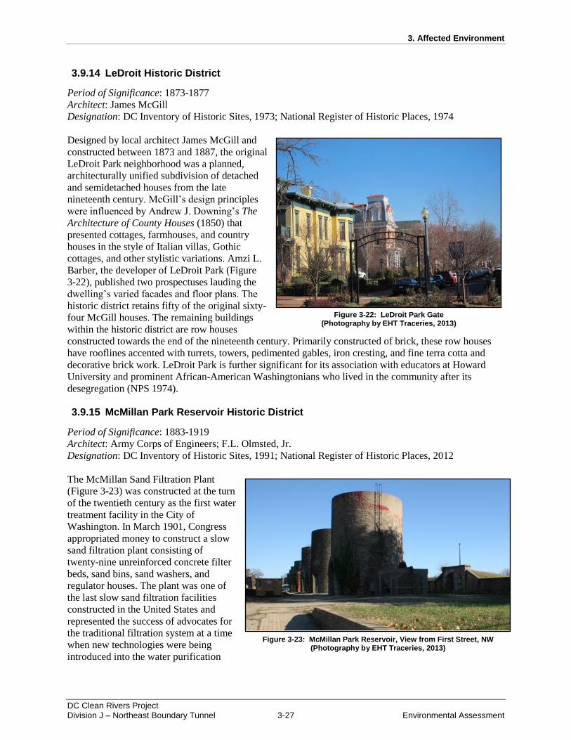
3.9.14 LeDroit Historic District
Period of Significance: 1873-1877
Architect: James McGill
Designation: DC Inventory of Historic Sites, 1973; National Register of Historic Places, 1974
Designed by local architect James McGill and
constructed between 1873 and 1887, the original
LeDroit Park neighborhood was a planned,
architecturally unified subdivision of detached
and semidetached houses from the late
nineteenth century. McGill’s design principles
were influenced by Andrew J. Downing’s The
Architecture of County Houses (1850) that
presented cottages, farmhouses, and country
houses in the style of Italian villas, Gothic
cottages, and other stylistic variations. Amzi L.
Barber, the developer of LeDroit Park (Figure
3-22), published two prospectuses lauding the
dwelling’s varied facades and floor plans. The
historic district retains fifty of the original sixty-
four McGill houses. The remaining buildings
within the historic district are row houses
constructed towards the end of the nineteenth century. Primarily constructed of brick, these row houses
have rooflines accented with turrets, towers, pedimented gables, iron cresting, and fine terra cotta and
decorative brick work. LeDroit Park is further significant for its association with educators at Howard
University and prominent African-American Washingtonians who lived in the community after its
desegregation (NPS 1974).
3.9.15 McMillan Park Reservoir Historic District
Period of Significance: 1883-1919
Architect: Army Corps of Engineers; F.L. Olmsted, Jr.
Designation: DC Inventory of Historic Sites, 1991; National Register of Historic Places, 2012
The McMillan Sand Filtration Plant
(Figure 3-23) was constructed at the turn
of the twentieth century as the first water
treatment facility in the City of
Washington. In March 1901, Congress
appropriated money to construct a slow
sand filtration plant consisting of
twenty-nine unreinforced concrete filter
beds, sand bins, sand washers, and
regulator houses. The plant was one of
the last slow sand filtration facilities
constructed in the United States and
represented the success of advocates for
the traditional filtration system at a time
when new technologies were being
introduced into the water purification
Figure 3-23: McMillan Park Reservoir, View from First Street, NW (Photography by EHT Traceries, 2013)
Figure 3-22: LeDroit Park Gate (Photography by EHT Traceries, 2013)
3. Affected Environment
DC Clean Rivers Project Division J – Northeast Boundary Tunnel 3-28 Environmental Assessment
process. Additionally, the new filtration system contributed to the elimination of typhoid epidemics and
reduced incidence of other diseases. In 1906, the filtration plant and adjacent reservoir were renamed
“McMillan Park” as a memorial to Senator James McMillan. From 1907 to 1911, renowned landscape
architect Frederick Law Olmsted developed the landscape design for the park. Olmsted’s application of
sophisticated landscape design as a means to enhance the site’s utilitarian infrastructure represents the
importance of public works as a part of the City Beautiful Movement. The site continued to operate until
1986 and retains its historic, cultural, landscape, planning, engineering, and architectural significance as
an urban engineering resource (NPS 2012b).
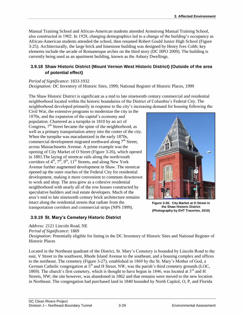
3.9.16 Mt. Olivet Cemetery Historic District
Address: 1300 Bladensburg Road, NE
Period of Significance: 1858
Designation: Potentially eligible for listing in the DC Inventory of Historic Sites and National Register of
Historic Places
Mt. Olivet Cemetery (Figure 3-24) is a Catholic cemetery in Northeast Washington, DC. In 1852, city
officials prohibited the location of new burial-grounds within the original city limits. Coupled with
financial difficulties of Catholic institutions
and a lack of space within existing burial
grounds, the city’s Catholic parishes
purchased approximately forty acres on the
west side of Bladensburg Road, north of the
city limits in 1857. Named Mt. Olivet
Cemetery, the new catholic burial grounds
opened in 1858 and served the area’s entire
catholic population (LOC 1858). The
cemetery represents the ideals of the Rural
Cemetery Movement and is potentially
eligible for listing in the DC Inventory of
Historic Sites, as well as the National
Register of Historic Places.
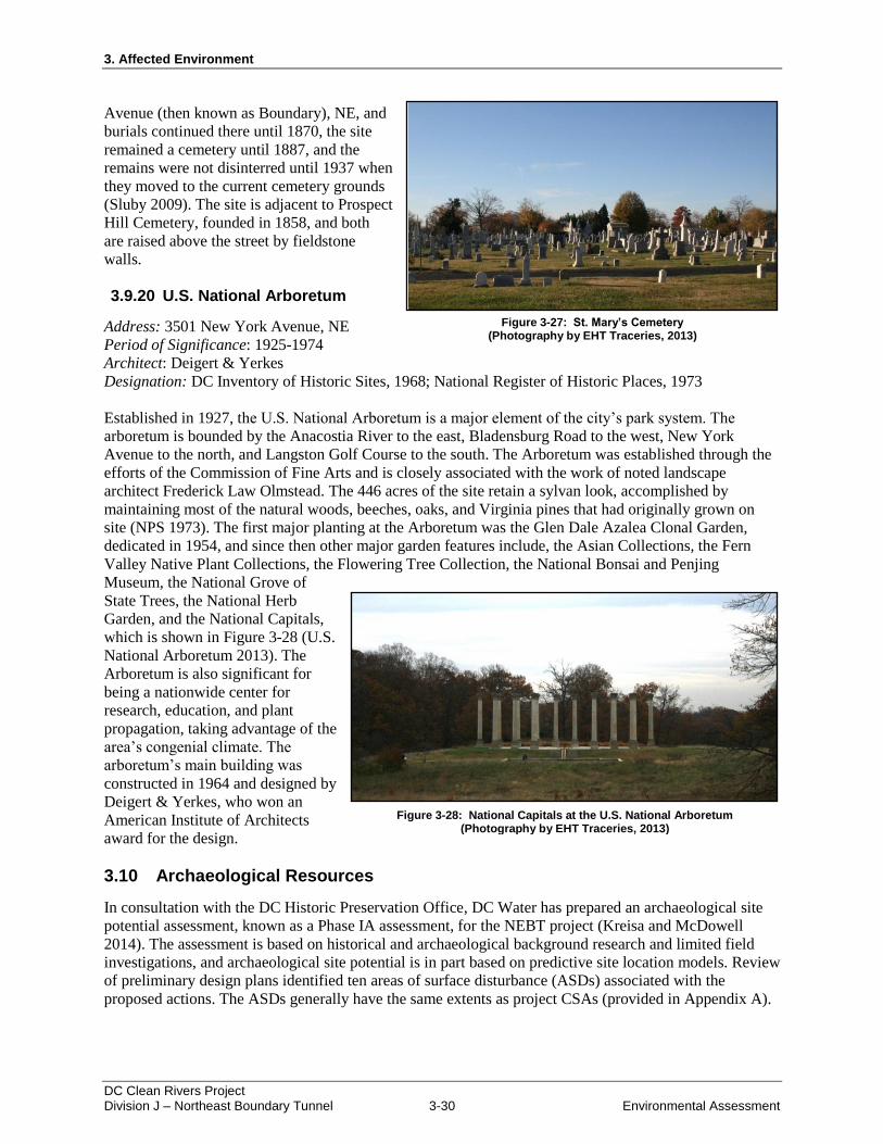
3.9.17 Robert Gould Shaw Junior High School (Outside of the area of potential effect)
Address: 650 Rhode Island Avenue, NW
Period of Significance: 1902-1907
Architect: Henry Ives Cobb
Designation: DC Inventory of Historic
Sites, 2008; National Register of Historic
Places, 2008
Constructed in 1902, Robert Gould Shaw
Junior High School (formerly known as
William McKinley Manual Training
School) reflected the prevailing
educational philosophy of the period that
promoted the idea of industrial training
alongside a more traditional academic
education. Due to segregation, white
students attended William McKinley
Figure 3-24: Mt. Olivet Cemetery, View from Mt. Olivet Road, NE
(Photography by EHT Traceries, 2013)
Figure 3-25: Robert Gould Shaw Junior High School (Photography by EHT Traceries, 2013)
3. Affected Environment
DC Clean Rivers Project Division J – Northeast Boundary Tunnel 3-29 Environmental Assessment
Manual Training School and African-American students attended Armstrong Manual Training School,
also constructed in 1902. In 1928, changing demographics led to a change of the building’s occupancy as
African-American students attended the school, then renamed Robert Gould Junior High School (Figure
3-25). Architecturally, the large brick and limestone building was designed by Henry Ives Cobb; key
elements include the arcade of Romanesque arches on the third story (DC HPO 2009). The building is
currently being used as an apartment building, known as the Asbury Dwellings.
3.9.18 Shaw Historic District (Mount Vernon West Historic District) (Outside of the area
of potential effect)
Period of Significance: 1833-1932
Designation: DC Inventory of Historic Sites, 1999; National Register of Historic Places, 1999
The Shaw Historic District is significant as a mid to late nineteenth century commercial and residential
neighborhood located within the historic boundaries of the District of Columbia’s Federal City. The
neighborhood developed primarily in response to the city’s increasing demand for housing following the
Civil War, the extensive programs to modernize the city in the
1870s, and the expansion of the capital’s economy and
population. Chartered as a turnpike in 1810 by an act of
Congress, 7th Street became the spine of the neighborhood, as
well as a primary transportation artery into the center of the city.
When the turnpike was macadamized in the early 1870s,
commercial development migrated northward along 7th Street,
across Massachusetts Avenue. A prime example was the
opening of City Market of O Street (Figure 3-26), which opened
in 1881.The laying of streetcar rails along the north/south
corridors of 4th, 7
th, 9
th, 11
th Streets, and along New York
Avenue further augmented development in Shaw. The streetcar
opened up the outer reaches of the Federal City for residential
development, making it more convenient to commute downtown
to work and shop. The area grew as a cohesive residential
neighborhood with nearly all of the row houses constructed by
speculative builders and real estate developers. Much of the
area’s mid to late nineteenth century brick architecture remains
intact along the residential streets that radiate from the
transportation corridors and commercial strips (NPS 1999).
3.9.19 St. Mary’s Cemetery Historic District
Address: 2121 Lincoln Road, NE
Period of Significance: 1869
Designation: Potentially eligible for listing in the DC Inventory of Historic Sites and National Register of
Historic Places
Located in the Northeast quadrant of the District, St. Mary’s Cemetery is bounded by Lincoln Road to the
east, V Street to the southwest, Rhode Island Avenue to the southeast, and a housing complex and offices
to the northeast. The cemetery (Figure 3-27), established in 1869 by the St. Mary’s Mother of God, a
German Catholic congregation at 5th and H Street, NW, was the parish’s third cemetery grounds (LOC,
1869). The church’s first cemetery, which is thought to have begun in 1846, was located at 3rd
and H
Streets, NW; the site however, was abandoned in 1862 and that remains were moved to the new location
in Northeast. The congregation had purchased land in 1840 bounded by North Capitol, O, P, and Florida
Figure 3-26: City Market at O Street in the Shaw Historic District
(Photography by EHT Traceries, 2010)
3. Affected Environment
DC Clean Rivers Project Division J – Northeast Boundary Tunnel 3-30 Environmental Assessment
Avenue (then known as Boundary), NE, and
burials continued there until 1870, the site
remained a cemetery until 1887, and the
remains were not disinterred until 1937 when
they moved to the current cemetery grounds
(Sluby 2009). The site is adjacent to Prospect
Hill Cemetery, founded in 1858, and both
are raised above the street by fieldstone
walls.
3.9.20 U.S. National Arboretum
Address: 3501 New York Avenue, NE
Period of Significance: 1925-1974
Architect: Deigert & Yerkes
Designation: DC Inventory of Historic Sites, 1968; National Register of Historic Places, 1973
Established in 1927, the U.S. National Arboretum is a major element of the city’s park system. The
arboretum is bounded by the Anacostia River to the east, Bladensburg Road to the west, New York
Avenue to the north, and Langston Golf Course to the south. The Arboretum was established through the
efforts of the Commission of Fine Arts and is closely associated with the work of noted landscape
architect Frederick Law Olmstead. The 446 acres of the site retain a sylvan look, accomplished by
maintaining most of the natural woods, beeches, oaks, and Virginia pines that had originally grown on
site (NPS 1973). The first major planting at the Arboretum was the Glen Dale Azalea Clonal Garden,
dedicated in 1954, and since then other major garden features include, the Asian Collections, the Fern
Valley Native Plant Collections, the Flowering Tree Collection, the National Bonsai and Penjing
Museum, the National Grove of
State Trees, the National Herb
Garden, and the National Capitals,
which is shown in Figure 3-28 (U.S.
National Arboretum 2013). The
Arboretum is also significant for
being a nationwide center for
research, education, and plant
propagation, taking advantage of the
area’s congenial climate. The
arboretum’s main building was
constructed in 1964 and designed by
Deigert & Yerkes, who won an
American Institute of Architects
award for the design.
3.10 Archaeological Resources
In consultation with the DC Historic Preservation Office, DC Water has prepared an archaeological site
potential assessment, known as a Phase IA assessment, for the NEBT project (Kreisa and McDowell
2014). The assessment is based on historical and archaeological background research and limited field
investigations, and archaeological site potential is in part based on predictive site location models. Review
of preliminary design plans identified ten areas of surface disturbance (ASDs) associated with the
proposed actions. The ASDs generally have the same extents as project CSAs (provided in Appendix A).
Figure 3-27: St. Mary’s Cemetery (Photography by EHT Traceries, 2013)
Figure 3-28: National Capitals at the U.S. National Arboretum (Photography by EHT Traceries, 2013)
3. Affected Environment
DC Clean Rivers Project Division J – Northeast Boundary Tunnel 3-31 Environmental Assessment
Results of a Project Data Request submitted to the DC Historic Preservation Office in July 2013 indicated
that none of the NEBT project ASDs had previously been surveyed for the presence of archaeological
resources and as a result, no known archaeological sites are located within the ASDs. Subsequently, a
review of the project limits of disturbance indicated that ASDs at the 4S-CSA, TS-CSA, and FLA-CSA,
are within areas previously disturbed by road and infrastructure construction. In contrast, there are four
ASDs located outside of previously disturbed roadways, parking areas, or sidewalks that would result in
significant ground disturbance. These ASDs are located within the MOR-CSA, WS-CSA, RIA-CSA, and
RS-CSA. Three additional ASDs have been evaluated under separate EAs or CATEXes for previous
DCCR projects. These include ASDs located within the CSO 019-CSA (including the high voltage
ductbank), PS-CSA, and CS-CSA.
3.10.1 CSO 019 Construction Staging Area (CSO 019-CSA) and High Voltage Ductbank
The archaeological potential of ASD associated with the CSO 019-CSA was evaluated as part of the
ARPs (NPS 2010). One previously identified archaeological site, 51SE030, is located within the western
portion of this ASD. This site was evaluated as not eligible for listing in the NRHP. For the eastern
portion of the ASD, a geoarchaeological evaluation indicated that this area was located on fill overlaying
portions of the river channel and associated mud flats. As such, that area was determined to have a low
potential for archaeological resources and no further archaeological investigations were conducted.
The high voltage ductbank described in Section 2.3.1 was reviewed by the National Park Service,
National Capital Parks-East who determined that the ductbank would be constructed on made-land within
areas that were formerly river bottom or mud flats. Based on this review, Dance (2012) determined that
no historic properties would be affected and no additional archaeological investigations were undertaken.
3.10.2 Mount Olivet Road, NE Construction Staging Area (MOR-CSA)
That portion of the ASD associated with the MOR-CSA at the intersection of Mt. Olivet Road and Capital
and West Virginia Avenues, is depicted as in the vicinity of a now-buried tributary stream of Tiber Creek.
Native American sites are often in close proximity to waterways. As such, this portion of the ASD would
have a moderate to high potential for the presence of Native American resources. In addition, this area
was the location of two small residences during the late nineteenth century and a number of row houses
during the twentieth century, three of which remain. Based on the presence of these structures, this
portion of the ASD has a high potential for Historic period archaeological resources. However, this area
has been impacted by the construction of a stormwater management system within an adjacent District
Housing Authority park. Current elevations, as much as 10 feet to 20 feet below those depicted on an
1888 topographic map, suggest that the area has been cut. While the ASD within the western portion of
the CSA has a high potential for archaeological resources, previous impacts have likely destroyed any
resources present.
That portion of the ASD located along Mt. Olivet Road, NE adjacent to Mt. Olivet Cemetery is located at
a greater distance from the now-buried tributary of Tiber Creek. As such, this portion of the ASD has a
low potential for the presence of Native American archaeological resources. Historic maps indicate that
this portion of the ASD has either been vacant or a parking lot and staging area for a nearby District
power plant. As such, this portion of the ASD would also have a low potential for the presence of Historic
period archaeological resources.
3.10.3 W Street, NE Construction Staging Area (WS-CSA)
Within the ASD located at the WS-CSA, historic maps dating to the second-half of the nineteenth century
depict a cluster of structures attributed to Mrs. E. Fenwick. Excepting the District Department of Public
Works facilities, no structures have been constructed within the ASD during the twentieth century. Based
3. Affected Environment
DC Clean Rivers Project Division J – Northeast Boundary Tunnel 3-32 Environmental Assessment
on the proximity of the W Street Junction Shaft ASD to structures depicted on mid- to late-nineteenth
century maps, this ASD has a high potential for the presence of Historic period archaeological resources.
The W Street Junction Shaft ASD is located east of a now-buried minor tributary stream of Tiber Creek.
While Native American sites are often in close proximity to waterways, the size of the tributary and
distance between the tributary and ASD indicates that the W Street Junction Shaft ASD would have a low
to moderate potential for the presence of Native American resources.
Stantec conducted an archaeological shovel test pit survey (Phase IB site survey) to determine whether
any archaeological resources associated with the mid-nineteenth century Fenwick residence were present
within the W Street ASD. While most of the ASD had been disturbed by cutting associated with the
construction of an access road that is present along the south ASD boundary, an area along W Street, NE
where an access road and retaining wall would be constructed had not been disturbed by prior activities.
Nineteen shovel test pits were excavated in this area, five of which yielded artifacts that date to the mid-
nineteenth century. These include transfer-printed and banded dinnerwares (whiteware, ironstone, and
pearlware), a tumbler fragment, a decanter stopper, and architectural materials.
3.10.4 Rhode Island Avenue, NE Construction Staging Area (RIA-CSA)
The majority of proposed ground-disturbing activities at the RIA-CSA are located within previously-
disturbed public right-of-ways that have no potential for the presence of archaeological resources. Map
analysis suggests that the private parcel located on the southwest corner of the intersection of Rhode
Island Avenue and 8th Place, NE has been subject to disturbance by prior cutting of soil horizons typically
associated with archaeological materials. This portion of RIA-CSA has no potential for the presence of
archaeological resources.
3.10.5 4th Street, NE Construction Staging Area (4S-CSA)
As all proposed ground-disturbing activities at the 4S-CSA are located within previously-disturbed public
right-of-ways, this location has no potential for the presence of archaeological resources.
3.10.6 T Street, NW Construction Staging Area (TS-CSA)
As all proposed ground-disturbing activities at the TS-CSA are located within previously-disturbed public
right-of-ways, this location has no potential for the presence of archaeological resources.
3.10.7 Pumping Station Construction Staging Area (PS-CSA)
Kreisa and McDowell (2013) document archaeological investigations undertaken at the PS-CSA
conducted as part of the First Street Tunnel Environmental Assessment. No archaeological resources were
identified, and the DC Historic Preservation Office has concurred with a finding of No Adverse Effect for
this location under DC Historic Preservation Laws.
3.10.8 Channing Street Mining Shaft Construction Staging Area (CS-CSA)
Kreisa and McDowell (2013) document archaeological investigations undertaken at the CS-CSA
conduceted as part of the First Street Tunnel Environmental Assessment. The area was found to have
been impacted by cut and fill activities. Because of this previous disturbance, the CS-CSA either has no
potential for the presence of archaeological resources or fill would protect any resources present from
proposed staging activities. The DC Historic Preservation Office has concurred with a finding of No
Adverse Effect for this location under DC Historic Preservation Laws.
3. Affected Environment
DC Clean Rivers Project Division J – Northeast Boundary Tunnel 3-33 Environmental Assessment
3.10.9 Florida Avenue, NW Construction Staging Area (FLA-CSA)
As all proposed ground-disturbing activities at the FLA-CSA are located within previously-disturbed
areas, this location has no potential for the presence of archaeological resources.
3.10.10 R Street, NW Construction Staging Area (RS-CSA)
Nineteenth and twentieth century maps suggest that Reservation 159 (now Cooper Park) has been
identified as a park since 1903. The RS-CSA is a relatively undisturbed parcel in an urban setting near a
now-buried tributary of Tiber Creek. Native American archaeological sites are often located near such
streams in the District. As such, the portion of the ASD associated with the RS-CSA outside of roadways
and sidewalks (within Reservation 159) has a moderate to high potential for the presence of Native
American archaeological resources.
A shovel test pit was excavated within Reservation 159 to determine whether intact soil horizons and
archaeological resources were present. Fill was recorded to 110 cm (43 inches or more than 3.5 feet)
below ground surface, at which point refusal was encountered. No archaeological resources were identied
during the analysis of the shovel test pit; however, construction activities proposed at the RS-CSA would
disturb soils below these fill doposits. As a result, there is potential for archaeological resources to exist
deeper below the ground surface. DC Water plans to complete a Phase IB investigation at the RS-CSA to
determine if archaeological resources exist at the site.
3.11 Human Health and Safety (including Hazardous Waste)
In 2012, several intense localized rain events occurred in the project area. Combined sewer overflows in
the neighborhoods overtopped manholes and inlets at numerous locations. Homes and businesses in
proximity to surcharged pipes experienced sewer backups. According to the Mayor’s Task Force Report,
over 200 properties reported some type of flooding. A range of flood conditions were reported, varying
from 2 to 24 inches of standing water and lasting from 15 minutes to 3 hours. Most of the reports
described backups occurring through toilet, bathtubs and sinks that were overtopped with sewage.
Cleanup efforts after the floods included mold remediation and removal of soiled carpets.
Data describing the extent of any illness caused by the sewer backups and associated cleanup efforts is
unavailable; however, exposure to untreated wastewaters is known to have health risks. Sewage contains
microorganisms, viruses and bacteria that can cause a range of symptoms from skin rashes to infection of
the gastrointestinal tract. Exposure to harmful microorganisms can continue for months after a sewer
backup in the walls, floors and furniture of a building (EPA 2013).
Additional health risks inherent to the project area include contaminated soil and groundwater. In order to
identify potential zones of soil and groundwater contamination, regulatory database listings were
reviewed. A summary of results is provided as follows.
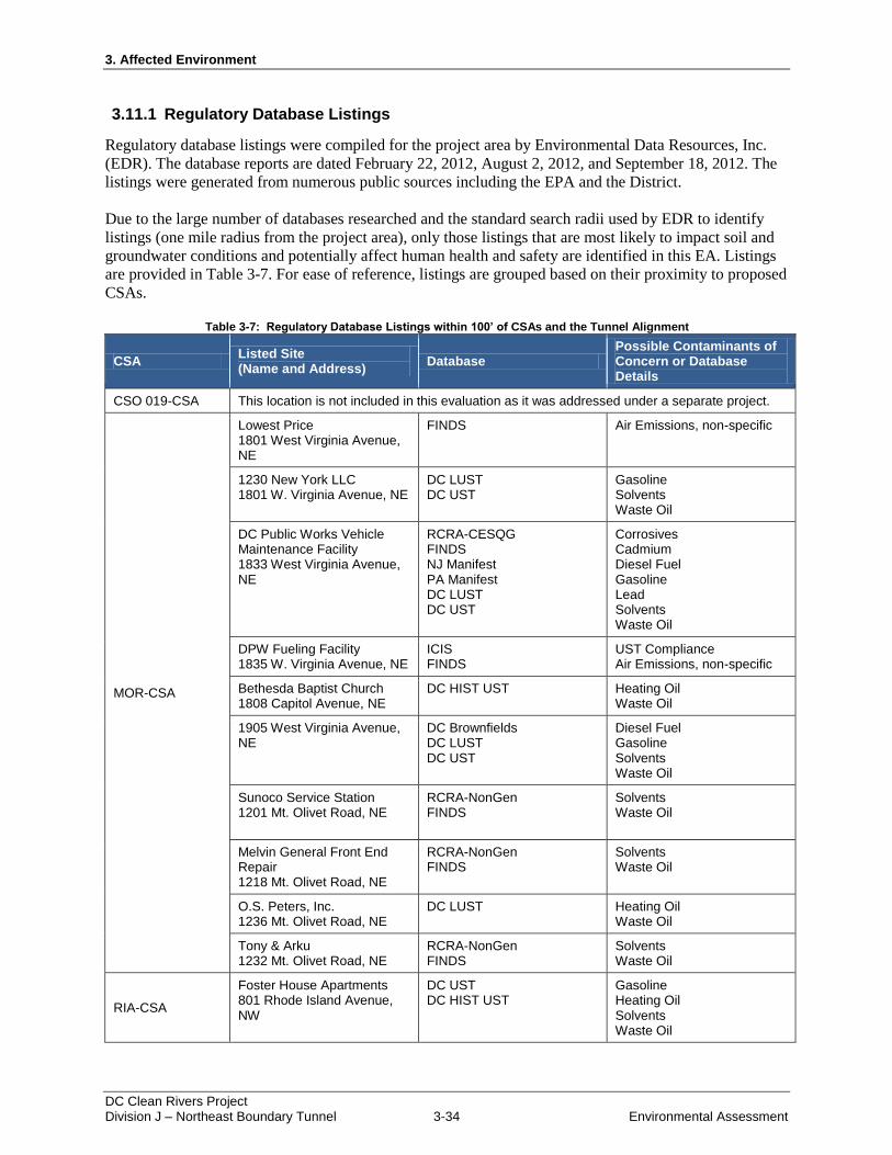
3. Affected Environment
DC Clean Rivers Project Division J – Northeast Boundary Tunnel 3-34 Environmental Assessment
3.11.1 Regulatory Database Listings
Regulatory database listings were compiled for the project area by Environmental Data Resources, Inc.
(EDR). The database reports are dated February 22, 2012, August 2, 2012, and September 18, 2012. The
listings were generated from numerous public sources including the EPA and the District.
Due to the large number of databases researched and the standard search radii used by EDR to identify
listings (one mile radius from the project area), only those listings that are most likely to impact soil and
groundwater conditions and potentially affect human health and safety are identified in this EA. Listings
are provided in Table 3-7. For ease of reference, listings are grouped based on their proximity to proposed
CSAs.
Table 3-7: Regulatory Database Listings within 100’ of CSAs and the Tunnel Alignment
CSA Listed Site (Name and Address)
Database Possible Contaminants of Concern or Database Details
CSO 019-CSA This location is not included in this evaluation as it was addressed under a separate project.
MOR-CSA
Lowest Price 1801 West Virginia Avenue, NE
FINDS Air Emissions, non-specific
1230 New York LLC 1801 W. Virginia Avenue, NE
DC LUST DC UST
Gasoline Solvents Waste Oil
DC Public Works Vehicle Maintenance Facility 1833 West Virginia Avenue, NE
RCRA-CESQG FINDS NJ Manifest PA Manifest DC LUST DC UST
Corrosives Cadmium Diesel Fuel Gasoline Lead Solvents Waste Oil
DPW Fueling Facility 1835 W. Virginia Avenue, NE
ICIS FINDS
UST Compliance Air Emissions, non-specific
Bethesda Baptist Church 1808 Capitol Avenue, NE
DC HIST UST Heating Oil Waste Oil
1905 West Virginia Avenue, NE
DC Brownfields DC LUST DC UST
Diesel Fuel Gasoline Solvents Waste Oil
Sunoco Service Station 1201 Mt. Olivet Road, NE
RCRA-NonGen FINDS
Solvents Waste Oil
Melvin General Front End Repair 1218 Mt. Olivet Road, NE
RCRA-NonGen FINDS
Solvents Waste Oil
O.S. Peters, Inc. 1236 Mt. Olivet Road, NE
DC LUST Heating Oil Waste Oil
Tony & Arku 1232 Mt. Olivet Road, NE
RCRA-NonGen FINDS
Solvents Waste Oil
RIA-CSA
Foster House Apartments 801 Rhode Island Avenue, NW
DC UST DC HIST UST
Gasoline Heating Oil Solvents Waste Oil
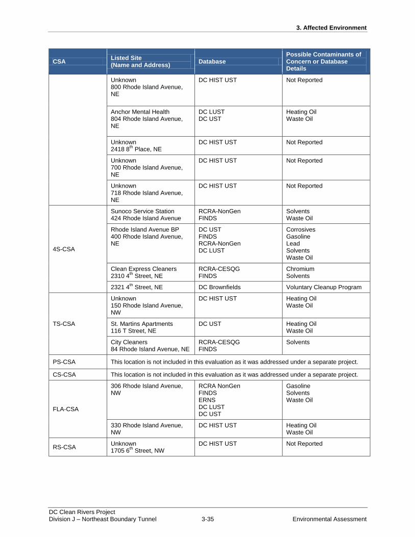
3. Affected Environment
DC Clean Rivers Project Division J – Northeast Boundary Tunnel 3-35 Environmental Assessment
CSA Listed Site (Name and Address)
Database Possible Contaminants of Concern or Database Details
Unknown 800 Rhode Island Avenue, NE
DC HIST UST Not Reported
Anchor Mental Health 804 Rhode Island Avenue, NE
DC LUST DC UST
Heating Oil Waste Oil
Unknown 2418 8
th Place, NE
DC HIST UST Not Reported
Unknown 700 Rhode Island Avenue, NE
DC HIST UST Not Reported
Unknown 718 Rhode Island Avenue, NE
DC HIST UST Not Reported
4S-CSA
Sunoco Service Station 424 Rhode Island Avenue
RCRA-NonGen FINDS
Solvents Waste Oil
Rhode Island Avenue BP 400 Rhode Island Avenue, NE
DC UST FINDS RCRA-NonGen DC LUST
Corrosives Gasoline Lead Solvents Waste Oil
Clean Express Cleaners 2310 4
th Street, NE
RCRA-CESQG FINDS
Chromium Solvents
2321 4th
Street, NE DC Brownfields Voluntary Cleanup Program
TS-CSA
Unknown 150 Rhode Island Avenue, NW
DC HIST UST Heating Oil Waste Oil
St. Martins Apartments 116 T Street, NE
DC UST Heating Oil Waste Oil
City Cleaners 84 Rhode Island Avenue, NE
RCRA-CESQG FINDS
Solvents
PS-CSA This location is not included in this evaluation as it was addressed under a separate project.
CS-CSA This location is not included in this evaluation as it was addressed under a separate project.
FLA-CSA
306 Rhode Island Avenue, NW
RCRA NonGen FINDS ERNS DC LUST DC UST
Gasoline Solvents Waste Oil
330 Rhode Island Avenue, NW
DC HIST UST Heating Oil Waste Oil
RS-CSA Unknown 1705 6
th Street, NW
DC HIST UST Not Reported
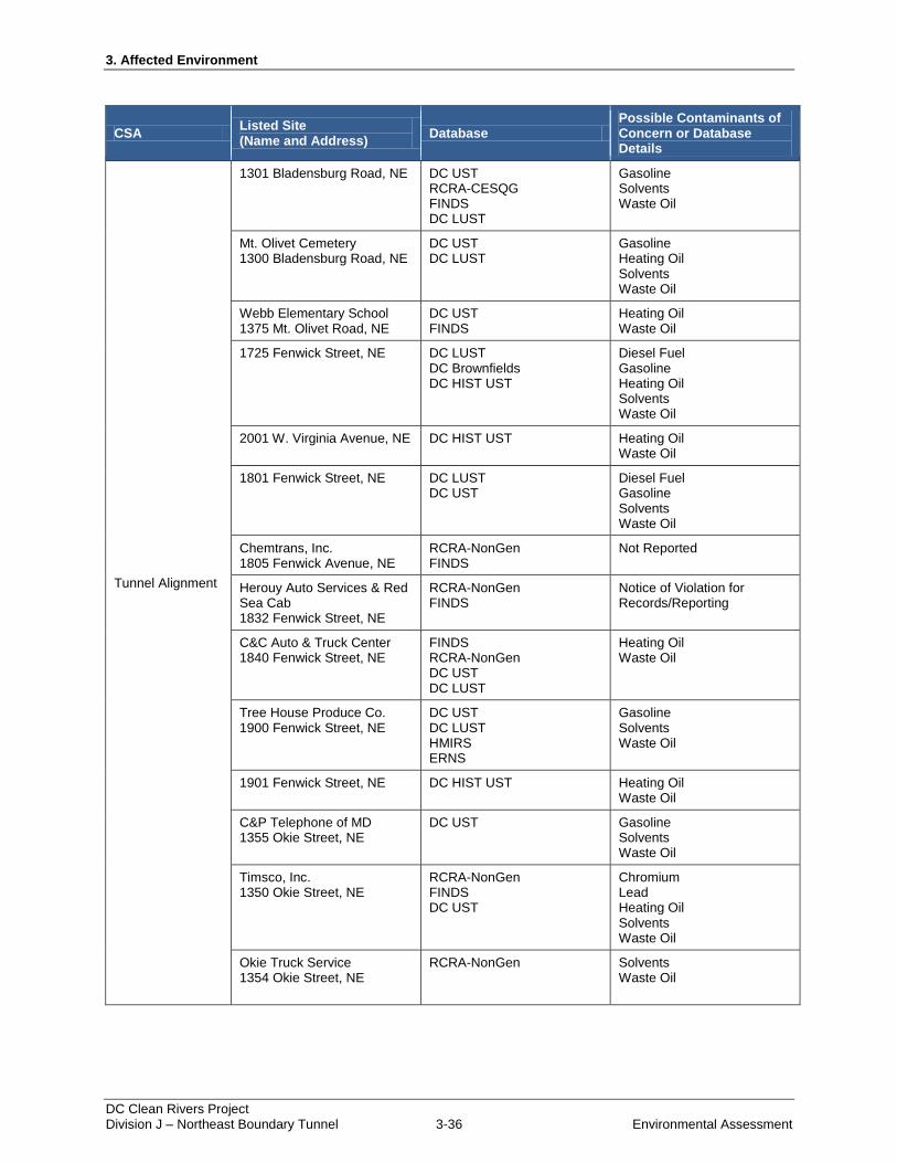
3. Affected Environment
DC Clean Rivers Project Division J – Northeast Boundary Tunnel 3-36 Environmental Assessment
CSA Listed Site (Name and Address)
Database Possible Contaminants of Concern or Database Details
Tunnel Alignment
1301 Bladensburg Road, NE DC UST RCRA-CESQG FINDS DC LUST
Gasoline Solvents Waste Oil
Mt. Olivet Cemetery 1300 Bladensburg Road, NE
DC UST DC LUST
Gasoline Heating Oil Solvents Waste Oil
Webb Elementary School 1375 Mt. Olivet Road, NE
DC UST FINDS
Heating Oil Waste Oil
1725 Fenwick Street, NE DC LUST DC Brownfields DC HIST UST
Diesel Fuel Gasoline Heating Oil Solvents Waste Oil
2001 W. Virginia Avenue, NE DC HIST UST Heating Oil Waste Oil
1801 Fenwick Street, NE DC LUST DC UST
Diesel Fuel Gasoline Solvents Waste Oil
Chemtrans, Inc. 1805 Fenwick Avenue, NE
RCRA-NonGen FINDS
Not Reported
Herouy Auto Services & Red Sea Cab 1832 Fenwick Street, NE
RCRA-NonGen FINDS
Notice of Violation for Records/Reporting
C&C Auto & Truck Center 1840 Fenwick Street, NE
FINDS RCRA-NonGen DC UST DC LUST
Heating Oil Waste Oil
Tree House Produce Co. 1900 Fenwick Street, NE
DC UST DC LUST HMIRS ERNS
Gasoline Solvents Waste Oil
1901 Fenwick Street, NE DC HIST UST Heating Oil Waste Oil
C&P Telephone of MD 1355 Okie Street, NE
DC UST Gasoline Solvents Waste Oil
Timsco, Inc. 1350 Okie Street, NE
RCRA-NonGen FINDS DC UST
Chromium Lead Heating Oil Solvents Waste Oil
Okie Truck Service 1354 Okie Street, NE
RCRA-NonGen Solvents Waste Oil
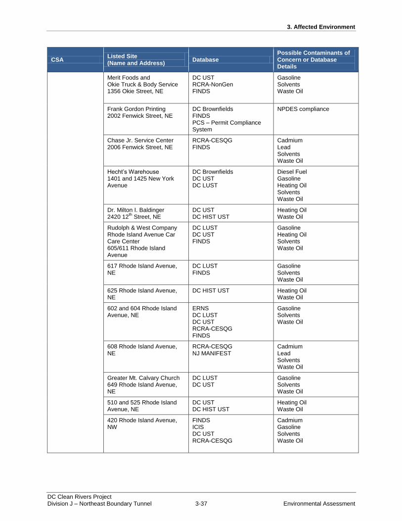
3. Affected Environment
DC Clean Rivers Project Division J – Northeast Boundary Tunnel 3-37 Environmental Assessment
CSA Listed Site (Name and Address)
Database Possible Contaminants of Concern or Database Details
Merit Foods and Okie Truck & Body Service 1356 Okie Street, NE
DC UST RCRA-NonGen FINDS
Gasoline Solvents Waste Oil
Frank Gordon Printing 2002 Fenwick Street, NE
DC Brownfields FINDS PCS – Permit Compliance System
NPDES compliance
Chase Jr. Service Center 2006 Fenwick Street, NE
RCRA-CESQG FINDS
Cadmium Lead Solvents Waste Oil
Hecht’s Warehouse 1401 and 1425 New York Avenue
DC Brownfields DC UST DC LUST
Diesel Fuel Gasoline Heating Oil Solvents Waste Oil
Dr. Milton I. Baldinger 2420 12
th Street, NE
DC UST DC HIST UST
Heating Oil Waste Oil
Rudolph & West Company Rhode Island Avenue Car Care Center 605/611 Rhode Island Avenue
DC LUST DC UST FINDS
Gasoline Heating Oil Solvents Waste Oil
617 Rhode Island Avenue, NE
DC LUST FINDS
Gasoline Solvents Waste Oil
625 Rhode Island Avenue, NE
DC HIST UST Heating Oil Waste Oil
602 and 604 Rhode Island Avenue, NE
ERNS DC LUST DC UST RCRA-CESQG FINDS
Gasoline Solvents Waste Oil
608 Rhode Island Avenue, NE
RCRA-CESQG NJ MANIFEST
Cadmium Lead Solvents Waste Oil
Greater Mt. Calvary Church 649 Rhode Island Avenue, NE
DC LUST DC UST
Gasoline Solvents Waste Oil
510 and 525 Rhode Island Avenue, NE
DC UST DC HIST UST
Heating Oil Waste Oil
420 Rhode Island Avenue, NW
FINDS ICIS DC UST RCRA-CESQG
Cadmium Gasoline Solvents Waste Oil
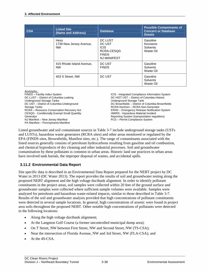
3. Affected Environment
DC Clean Rivers Project Division J – Northeast Boundary Tunnel 3-38 Environmental Assessment
CSA Listed Site (Name and Address)
Database Possible Contaminants of Concern or Database Details
Hess 1739 New Jersey Avenue, NW
DC LUST DC UST ICIS RCRA-CESQG FINDS NJ MANIFEST
Gasoline Kerosene Solvents Waste Oil
415 Rhode Island Avenue, NW
DC UST FINDS
Gasoline Solvents Waste Oil
403 S Street, NW DC UST Gasoline Solvents Waste Oil
Acronyms : FINDS – Facility Index System DC LUST – District of Columbia Leaking Underground Storage Tanks DC UST – District of Columbia Underground Storage Tanks RCRA – Resource Conservation Recovery Act CESQG - Conditionally Exempt Small Quantity Generator NJ Manifest – New Jersey Manifest PA Manifest – Pennsylvania Manifest
ICIS - Integrated Compliance Information System DC HIST UST – District of Columbia Historic Underground Storage Tank DC Brownfields – District of Columbia Brownfields RCRA-NonGen – RCRA Non-Generator ERNS – Emergency Release Notification System HMIRS - Hazardous Material Incident Reporting System (transportation regulation) PCS – Permit Compliance System
Listed groundwater and soil contaminant sources in Table 3-7 include underground storage tanks (USTs
and LUSTs), hazardous waste generators (RCRA sites) and other areas monitored or regulated by the
EPA (FINDS sites, Brownfields, Manifest sites, etc.). The range of contaminants associated with the
listed sources generally consists of petroleum hydrocarbons resulting from gasoline and oil combustion,
and chemical byproducts of dry cleaning and other industrial processes. Soil and groundwater
contamination by these pollutants is common in urban areas. Historic land use practices in urban areas
have involved tank burials, the improper disposal of wastes, and accidental spills.
3.11.2 Environmental Data Report
Site specific data is described in an Environmental Data Report prepared for the NEBT project by DC
Water in 2013 (DC Water 2013). The report provides the results of soil and groundwater testing along the
proposed NEBT alignment and the high voltage ductbank alignment. In order to identify pollutant
constituents in the project areas, soil samples were collected within 20 feet of the ground surface and
groundwater samples were collected where sufficient sample volumes were available. Samples were
analyzed for petroleum and hazardous waste-related impacts, similar to those described in Table 3-7.
Results of the soil and groundwater analysis provided that high concentrations of pollutant constituents
were detected in several sample locations. In general, high concentrations of arsenic were found in project
area soils throughout the proposed NEBT. Other notable high concentrations of pollutants were detected
in the following locations:
Along the high voltage ductbank alignment;
At the Langston Golf Course (a former uncontrolled municipal dump area);
On T Street, NW between First Street, NW and Second Street, NW (TS-CSA);
Near the intersection of Florida Avenue, NW and 3rd Street, NW (FLA-CSA); and
At the 4S-CSA.
3. Affected Environment
DC Clean Rivers Project Division J – Northeast Boundary Tunnel 3-39 Environmental Assessment
Soil pollutants included volatile organic compunds (VOCs), semi volatile organic compounds (SVOCs),
and PCBs, which were present at concentrations exceeding the EPA’s Regional Screening Levels (RSLs)
for chemical contaminants. VOCs and SVOCs were detected in 33 samples throughout the project area,
and PCBs were detected in 2 samples along the high voltage ductbank alignment. In addition, leachable
lead was detected in concentrations exceeding EPA regulatory limits at the Langston Golf Course. In the
District, a risk evaluation is required for development of sites that exceed the District Department of
Environment’s Tier 1 standards for soil and groundwater contaminants (DDOE 2014a). As described in
the Environmental Data Report, one of the pollutant concentrations in soil samples exceeded the District’s
Tier 1 standards for soils, recovered from the FLA-CSA area.
Additional groundwater sampling was performed by DC Water at the MOR-CSA and the FLA-CSA in
January 2014, to further characterize site conditions. At the MOR-CSA, all constituent concentrations
were below District standards for groundwater contamination. At the FLA-CSA, field observations
indicated that petroleum hydrocarbon contamination associated with a former leaking underground
storage tank is present. Investigation into the extents of soil contamination at the FLA-CSA and
development of remedial measures is ongoing.
3.12 Transportation (Traffic)
In December 2013, a traffic study for the NEBT project was prepared by DC Water based on
recommendations provided by the District Department of Transportation. Three study areas were
identified based on the locations of proposed CSAs. Figure 3-29, Figure 3-30, and Figure 3-31 depict the
study areas.
Figure 3-29: Traffic Study Area #1
Figure 3-29 Traffic Study Area #1
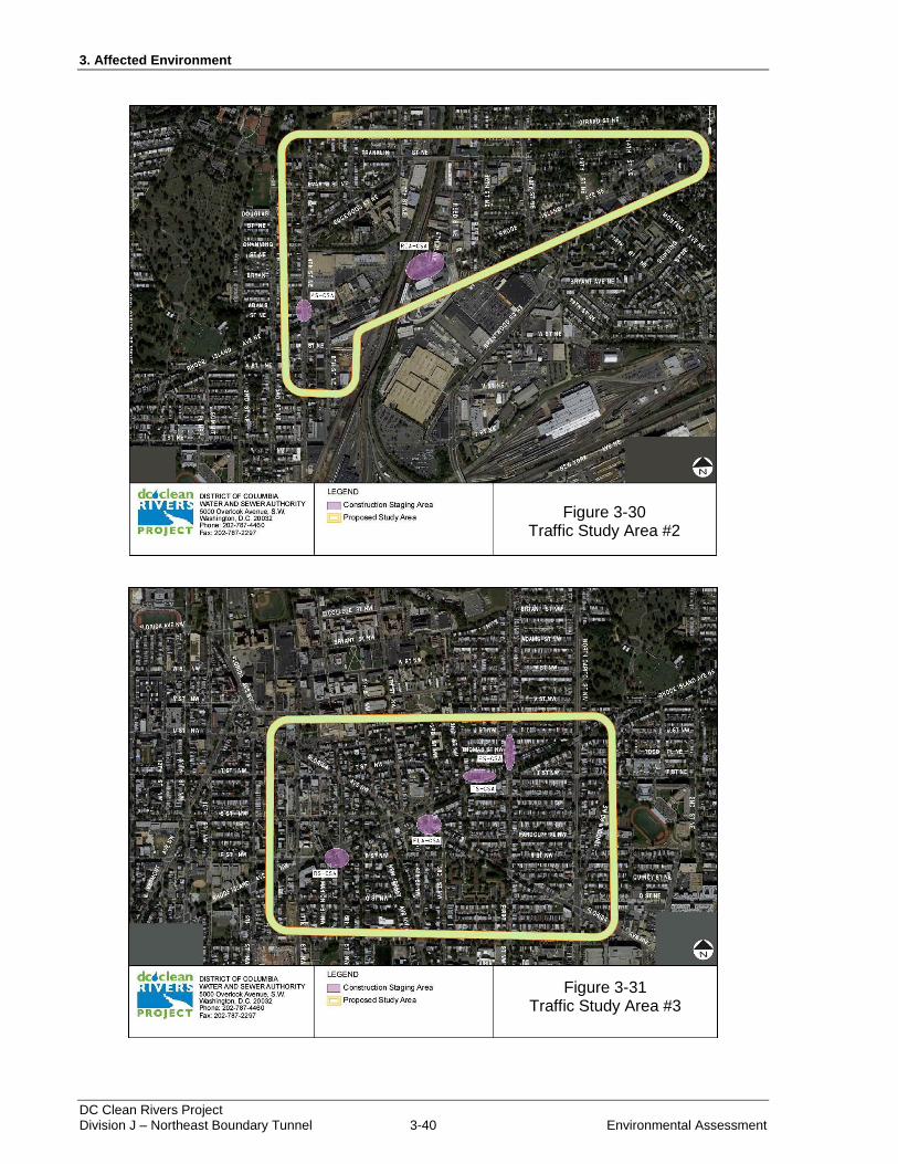
3. Affected Environment
DC Clean Rivers Project Division J – Northeast Boundary Tunnel 3-40 Environmental Assessment
Figure 3-30: Traffic Study Area #2
Figure 3-31: Traffic Study Area #3
Figure 3-30 Traffic Study Area #2
Figure 3-31 Traffic Study Area #3
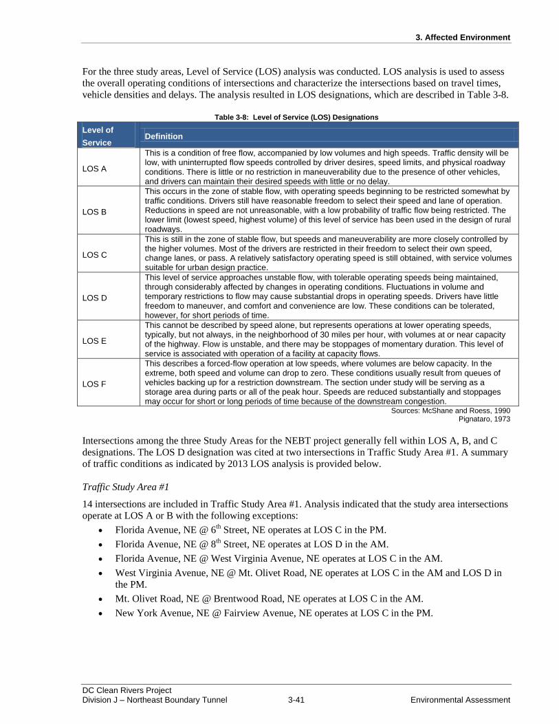
3. Affected Environment
DC Clean Rivers Project Division J – Northeast Boundary Tunnel 3-41 Environmental Assessment
For the three study areas, Level of Service (LOS) analysis was conducted. LOS analysis is used to assess
the overall operating conditions of intersections and characterize the intersections based on travel times,
vehicle densities and delays. The analysis resulted in LOS designations, which are described in Table 3-8.
Table 3-8: Level of Service (LOS) Designations
Level of
Service Definition
LOS A
This is a condition of free flow, accompanied by low volumes and high speeds. Traffic density will be low, with uninterrupted flow speeds controlled by driver desires, speed limits, and physical roadway conditions. There is little or no restriction in maneuverability due to the presence of other vehicles, and drivers can maintain their desired speeds with little or no delay.
LOS B
This occurs in the zone of stable flow, with operating speeds beginning to be restricted somewhat by traffic conditions. Drivers still have reasonable freedom to select their speed and lane of operation. Reductions in speed are not unreasonable, with a low probability of traffic flow being restricted. The lower limit (lowest speed, highest volume) of this level of service has been used in the design of rural roadways.
LOS C
This is still in the zone of stable flow, but speeds and maneuverability are more closely controlled by the higher volumes. Most of the drivers are restricted in their freedom to select their own speed, change lanes, or pass. A relatively satisfactory operating speed is still obtained, with service volumes suitable for urban design practice.
LOS D
This level of service approaches unstable flow, with tolerable operating speeds being maintained, through considerably affected by changes in operating conditions. Fluctuations in volume and temporary restrictions to flow may cause substantial drops in operating speeds. Drivers have little freedom to maneuver, and comfort and convenience are low. These conditions can be tolerated, however, for short periods of time.
LOS E
This cannot be described by speed alone, but represents operations at lower operating speeds, typically, but not always, in the neighborhood of 30 miles per hour, with volumes at or near capacity of the highway. Flow is unstable, and there may be stoppages of momentary duration. This level of service is associated with operation of a facility at capacity flows.
LOS F
This describes a forced-flow operation at low speeds, where volumes are below capacity. In the extreme, both speed and volume can drop to zero. These conditions usually result from queues of vehicles backing up for a restriction downstream. The section under study will be serving as a storage area during parts or all of the peak hour. Speeds are reduced substantially and stoppages may occur for short or long periods of time because of the downstream congestion.
Sources: McShane and Roess, 1990 Pignataro, 1973
Intersections among the three Study Areas for the NEBT project generally fell within LOS A, B, and C
designations. The LOS D designation was cited at two intersections in Traffic Study Area #1. A summary
of traffic conditions as indicated by 2013 LOS analysis is provided below.
Traffic Study Area #1
14 intersections are included in Traffic Study Area #1. Analysis indicated that the study area intersections
operate at LOS A or B with the following exceptions:
Florida Avenue, NE @ 6th Street, NE operates at LOS C in the PM.
Florida Avenue, NE @ 8th Street, NE operates at LOS D in the AM.
Florida Avenue, NE @ West Virginia Avenue, NE operates at LOS C in the AM.
West Virginia Avenue, NE @ Mt. Olivet Road, NE operates at LOS C in the AM and LOS D in
the PM.
Mt. Olivet Road, NE @ Brentwood Road, NE operates at LOS C in the AM.
New York Avenue, NE @ Fairview Avenue, NE operates at LOS C in the PM.
3. Affected Environment
DC Clean Rivers Project Division J – Northeast Boundary Tunnel 3-42 Environmental Assessment
Traffic Study Area #2
19 intersections are included in Traffic Study Area #2. Analysis indicated that the study area intersections
operate at LOS A or B with the following exceptions:
Rhode Island Avenue, NE @ 4th Street, NE operates at LOS C in the AM.
Rhode Island Avenue, NE @ Reed Street, NE operates at LOS C in the AM.
Rhode Island Avenue, NE @ 12th Street, NE operates at LOS C in the PM.
Rhode Island Avenue, NE @ Franklin Avenue, NE operates at LOS C in the AM and PM.
Franklin Street, NE @ 7th Street, NE operates at LOS C in the AM.
Franklin Street, NE @ 12th Street, NE operates at LOS C in the AM and PM.
Franklin Street, NE @ 13th Street, NE operates at LOS C in the AM and PM.
Franklin Street, NE @ 14th Street, NE operates at LOS C in the PM.
Traffic Study Area #3
30 intersections are included in Traffic Study Area #3. Analysis indicated that the study area intersections
operate at LOS A or B with the following exceptions:
Florida Avenue, NW @ 7th Street NW operates at LOS C in the AM and PM.
Florida Avenue, NW @ 1st Street NW operates at LOS C in the AM and PM.
Florida Avenue, NW @ North Capitol Street NW operates at LOS C in the PM.
7th Street, NW @ R Street, NW operates at LOS C in the PM.
6th Street, NW @ S Street, NW operates at LOS C in the AM and PM.
1st Street, NW @ Q Street, NW operates at LOS C in the AM.
North Capitol Street, NW @ Randolph Street, NW operates at LOS C in the AM.
3.13 Socioeconomics
3.13.1 Population and Housing
Census tracts within the project area surrounding the CSAs include 33.01, 33.02, 34, 46, 48.01, 87.02,
88.03, 88.04, 91.02, 92.04, and 93.02 (see Figure 3-32). These census tracts were used to analyze impacts
to socioeconomics within the projects area. Data for census tracts falling along the alignment in areas
where there are no CSAs were not used in this analysis as impacts in these areas would occur below
ground.
Population data from the 2010 Census were used to determine current population numbers for the area.
Table 3-9 provides a summary of the demographic characteristics for all the census tracts surround CSAs.
The predominant race in these areas is black, with percentages higher than the District in all tracts except
48.01 near the RS-CSA (Census 2010). The percentage of white individuals in the study area is highest in
Census Tract 48.01 (39.5 percent) and lowest in Census Tract 91.02, with the other census tracts ranging
from 4.4 percent to 34.4 percent. The percentage of Asian individuals (5.7 percent) is also highest in
Census Tract 48.01, followed by 3.2 percent in Census Tract 46, 2.7 percent in Census Tract 88.03, and
2.2 percent in Census Tract 34 with percentages less than 2.0 in the remaining census tracts. Census Tract
93.02 has the highest percentage of individuals who are some other race (9.1 percent) and Census Tract
48.01 has the highest percentage of individuals who are two or more races (4.6 percent).
The Hispanic/Latino population in the study area is similar to the District as a whole (Census 2010).
Hispanic/Latinos make up approximately 12.4 percent of the population in Census Tract 92.04, followed
by 10.5 percent of the population in Census Tract 93.02, 8.9 percent of the population in Census Tract

3. Affected Environment
DC Clean Rivers Project Division J – Northeast Boundary Tunnel 3-43 Environmental Assessment
48.01, and 8.2 percent of the population in Census Tract 88.03. The Hispanic/Latino population is lowest
in Census Tract 33.01 (3.9 percent). The remaining census tracts range between 4.2 percent and 7.3
percent. Approximately 9.1 percent of the District population is Hispanic/Latino.
There are 13,242 housing units within the census tracts surrounding the project area CSAs (Census
2013c). Of these, 2,167 units were vacant, 39.0 percent were owner-occupied, and 44.6 percent were
renter-occupied.
3.13.2 Economy, Employment, Income, and Education
According to the 2007 – 2011 American Community Survey, 38.3 percent of working residents in the
District are in management, business, science and arts occupations. Sales and office occupations follow at
23.7 percent, and service occupations at 16.9 percent. Of the working population in the District, 11.0
percent are in production, transportation, and material moving occupations and 10.0 percent in natural
resources, construction, and maintenance occupations employ (Census, 2013b).
The educational services, health care, and social assistance industry employs 21.0 percent of the working
population in the study area (Census, 2013b). Professional, scientific, management, administrative, and
waste management services industries employ 11.8 percent of the working population. The retail trade
employs 11.6 percent of the working population; followed by the manufacturing industry at 10.5 percent;
the arts, entertainment, recreation, accommodation, and food services industry at 8.8 percent; the
construction industry at 7.0 percent; the finance/insurance/real estate/rental and leasing industry at 6.0
percent; public administration at 5.4 percent; transportation, warehousing, and utilities industry at 5.1
percent; and other services (except public administration) at 4.6 percent. The wholesale trade; agriculture,
forestry, fishing, hunting, and mining; and information industries make up the remaining 8.1 percent.
Table 3-10 lists data pertaining to employment, income, and education. As of August 2013, the District’s
unemployment rate was 8.7 percent, higher than the national average of 7.3 percent (BLS, 2013). The
median household income is $58,890, compared to the national average of $52,762.
Within the census tracts surrounding the CSAs the median household income is highest in Census Tract
48.01 ($96,534), higher than that of the District as a whole (Census, 2013b). The median household
income is lowest in Census Tract 88.04. The percentage of individuals living below the poverty is highest
in Census Tract 88.03 (49.2 percent) and lowest in Census Tract 93.02 (3.1 percent). The percentage of
unemployed individuals is highest in Census Tract 88.04 (11.1 percent) and the lowest in Census Tract
93.02 (3.7 percent).
Within the census tracts surrounding the CSAs the census tract with individuals with the highest number
advanced degrees is Census Tract 33.02 (62.1 percent), higher than that of the District as a whole
(Census, 2013a). The census tract with the lowest number of advanced degrees is Census Tract 88.04
(11.4 percent). Approximately 53 percent of the District’s population has advanced degrees. The census
tract with the highest percentage of individuals having less than a ninth grade education is Census Tract
92.04 (16.6 percent). Census Tract 33.01 and 46 have the lowest percentage of individuals having less
than a ninth grade education at 0.7 percent. Approximately 4.4 percent of the District’s population has
less than a ninth grade education.
3. Affected Environment
DC Clean Rivers Project Division J – Northeast Boundary Tunnel 3-44 Environmental Assessment
3.13.3 Taxes and Revenue
The following taxes and revenues are collected by the District (DCCFO, 2013):
Individual Income Taxes: Individual income taxes are levied on all individuals who are domiciled in the
District at any time during the tax year, or who maintains an abode in the District for 183 or more days
during the year as follows:
4 percent on the first $10,000 of taxable income
$400 + 6 percent on taxable income between $10,001 and $40,000
$2,200 + 8.5 percent on taxable income between $40,001 and $350,000
$28,550 + 8.95 percent of excess over $350,001
Income from Social Security and up to $3,000 of military retired pay, pension income or annuity income
is excluded.
Sales and Use Taxes: For Tax Year 2013, the District imposes a 5.75 percent sales tax on taxable goods
and services (exemptions from sales tax include groceries, prescription and non-prescription drugs, and
residential utility services).
Real Property Tax Rates: The amount of tax due is determined by dividing the assessed value of the
property by $100, then multiplying that amount by the rate. For Tax Year 2013, the rate on residential real
property is $0.85 including multifamily units.
Corporate Franchise and Unincorporated Franchise Taxes: The District’s franchise tax is imposed
on all corporations and unincorporated businesses doing business in the District on the basis of the net
taxable business income apportioned to the District. The franchise tax rate is currently 9.975 percent.

3. Affected Environment
DC Clean Rivers Project Division J – Northeast Boundary Tunnel 3-45 Environmental Assessment
Figure 3-32: Census Tracts within the Study Area
Figure 3-32 Census Tracts
within the Study Area
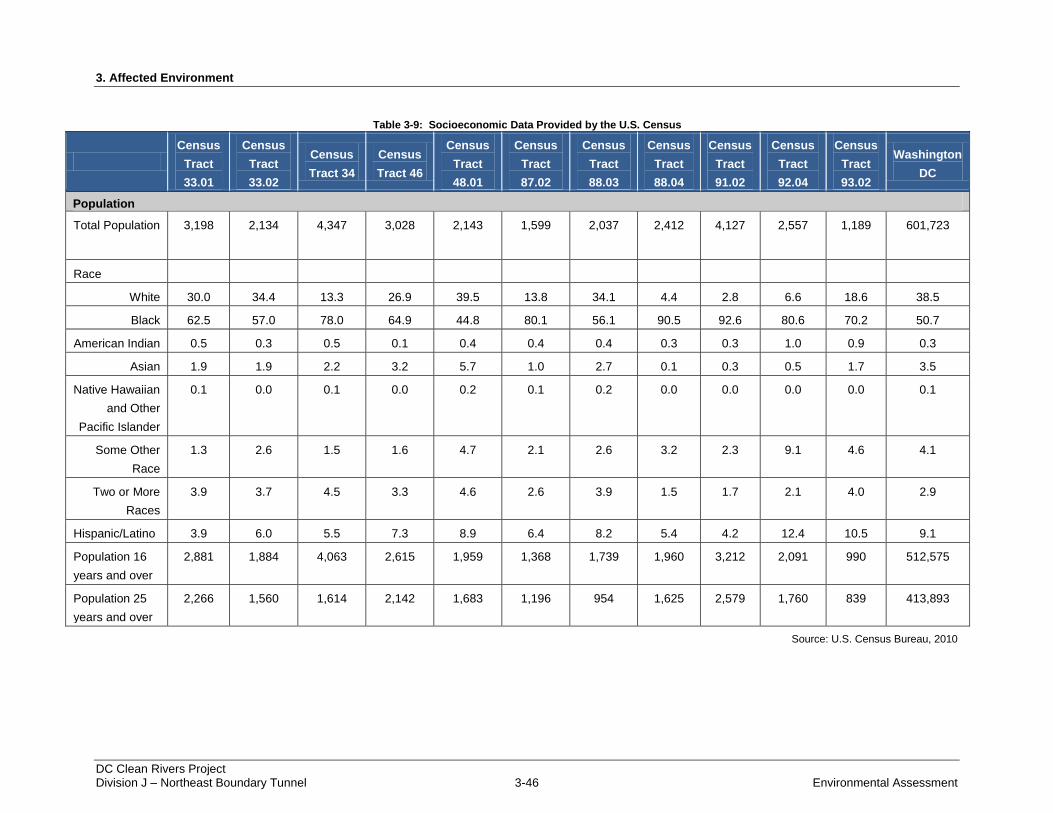
3. Affected Environment
DC Clean Rivers Project Division J – Northeast Boundary Tunnel 3-46 Environmental Assessment
Table 3-9: Socioeconomic Data Provided by the U.S. Census
Census
Tract
33.01
Census
Tract
33.02
Census
Tract 34
Census
Tract 46
Census
Tract
48.01
Census
Tract
87.02
Census
Tract
88.03
Census
Tract
88.04
Census
Tract
91.02
Census
Tract
92.04
Census
Tract
93.02
Washington
DC
Population
Total Population 3,198 2,134 4,347 3,028 2,143 1,599 2,037 2,412 4,127 2,557 1,189 601,723
Race
White 30.0 34.4 13.3 26.9 39.5 13.8 34.1 4.4 2.8 6.6 18.6 38.5
Black 62.5 57.0 78.0 64.9 44.8 80.1 56.1 90.5 92.6 80.6 70.2 50.7
American Indian 0.5 0.3 0.5 0.1 0.4 0.4 0.4 0.3 0.3 1.0 0.9 0.3
Asian 1.9 1.9 2.2 3.2 5.7 1.0 2.7 0.1 0.3 0.5 1.7 3.5
Native Hawaiian
and Other
Pacific Islander
0.1 0.0 0.1 0.0 0.2 0.1 0.2 0.0 0.0 0.0 0.0 0.1
Some Other
Race
1.3 2.6 1.5 1.6 4.7 2.1 2.6 3.2 2.3 9.1 4.6 4.1
Two or More
Races
3.9 3.7 4.5 3.3 4.6 2.6 3.9 1.5 1.7 2.1 4.0 2.9
Hispanic/Latino 3.9 6.0 5.5 7.3 8.9 6.4 8.2 5.4 4.2 12.4 10.5 9.1
Population 16
years and over
2,881 1,884 4,063 2,615 1,959 1,368 1,739 1,960 3,212 2,091 990 512,575
Population 25
years and over
2,266 1,560 1,614 2,142 1,683 1,196 954 1,625 2,579 1,760 839 413,893
Source: U.S. Census Bureau, 2010
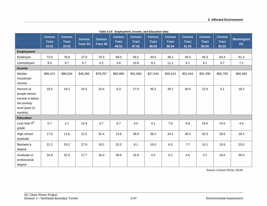
3. Affected Environment
DC Clean Rivers Project Division J – Northeast Boundary Tunnel 3-47 Environmental Assessment
Table 3-10: Employment, Income, and Education Data
Census
Tract
33.01
Census
Tract
33.02
Census
Tract 34
Census
Tract 46
Census
Tract
48.01
Census
Tract
87.02
Census
Tract
88.03
Census
Tract
88.04
Census
Tract
91.02
Census
Tract
92.04
Census
Tract
93.02
Washington
DC
Employment
Employed 72.0 78.8 37.9 70.3 68.0 49.2 44.5 48.1 45.5 49.3 64.4 61.3
Unemployed 9.0 6.7 5.7 4.2 4.6 10.9 9.2 11.1 9.1 9.1 3.7 7.1
Income
Median
household
income
$86,101 $96,534 $46,365 $78,257 $82,866 $51,650 $27,344 $26,615 $31,544 $31,290 $65,700 $66,583
Percent of
people whose
income is below
the poverty
level (past 12
months)
18.5 16.2 20.4 10.4 6.3 17.0 49.2 39.7 30.0 22.9 3.1 18.2
Education
Less than 9th
grade
0.7 2.1 12.4 0.7 6.7 4.5 4.1 7.8 6.8 16.6 14.5 4.4
High school
graduate
17.8 11.6 21.5 32.4 13.6 28.9 38.2 34.1 38.3 32.3 28.6 18.4
Bachelor’s
degree
21.2 29.2 27.9 19.2 25.2 8.1 15.0 6.3 7.7 10.1 15.5 23.0
Graduate or
professional
degree
34.8 32.9 17.7 18.3 28.6 16.9 4.0 5.2 4.6 3.7 16.6 30.0
Source: Census 2013a, 2013b
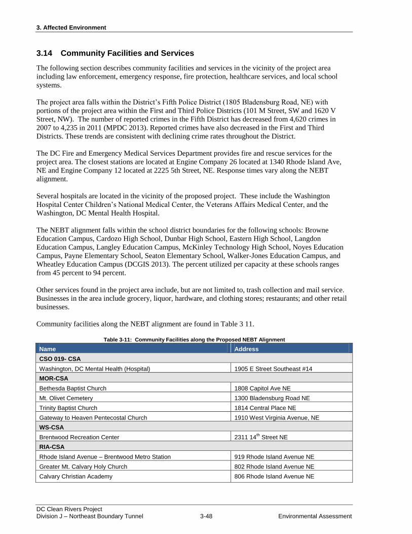
3. Affected Environment
DC Clean Rivers Project Division J – Northeast Boundary Tunnel 3-48 Environmental Assessment
3.14 Community Facilities and Services
The following section describes community facilities and services in the vicinity of the project area
including law enforcement, emergency response, fire protection, healthcare services, and local school
systems.
The project area falls within the District’s Fifth Police District (1805 Bladensburg Road, NE) with
portions of the project area within the First and Third Police Districts (101 M Street, SW and 1620 V
Street, NW). The number of reported crimes in the Fifth District has decreased from 4,620 crimes in
2007 to 4,235 in 2011 (MPDC 2013). Reported crimes have also decreased in the First and Third
Districts. These trends are consistent with declining crime rates throughout the District.
The DC Fire and Emergency Medical Services Department provides fire and rescue services for the
project area. The closest stations are located at Engine Company 26 located at 1340 Rhode Island Ave,
NE and Engine Company 12 located at 2225 5th Street, NE. Response times vary along the NEBT
alignment.
Several hospitals are located in the vicinity of the proposed project. These include the Washington
Hospital Center Children’s National Medical Center, the Veterans Affairs Medical Center, and the
Washington, DC Mental Health Hospital.
The NEBT alignment falls within the school district boundaries for the following schools: Browne
Education Campus, Cardozo High School, Dunbar High School, Eastern High School, Langdon
Education Campus, Langley Education Campus, McKinley Technology High School, Noyes Education
Campus, Payne Elementary School, Seaton Elementary School, Walker-Jones Education Campus, and
Wheatley Education Campus (DCGIS 2013). The percent utilized per capacity at these schools ranges
from 45 percent to 94 percent.
Other services found in the project area include, but are not limited to, trash collection and mail service.
Businesses in the area include grocery, liquor, hardware, and clothing stores; restaurants; and other retail
businesses.
Community facilities along the NEBT alignment are found in Table 3 11.
Table 3-11: Community Facilities along the Proposed NEBT Alignment
Name Address
CSO 019- CSA
Washington, DC Mental Health (Hospital) 1905 E Street Southeast #14
MOR-CSA
Bethesda Baptist Church 1808 Capitol Ave NE
Mt. Olivet Cemetery 1300 Bladensburg Road NE
Trinity Baptist Church 1814 Central Place NE
Gateway to Heaven Pentecostal Church 1910 West Virginia Avenue, NE
WS-CSA
Brentwood Recreation Center 2311 14th
Street NE
RIA-CSA
Rhode Island Avenue – Brentwood Metro Station 919 Rhode Island Avenue NE
Greater Mt. Calvary Holy Church 802 Rhode Island Avenue NE
Calvary Christian Academy 806 Rhode Island Avenue NE
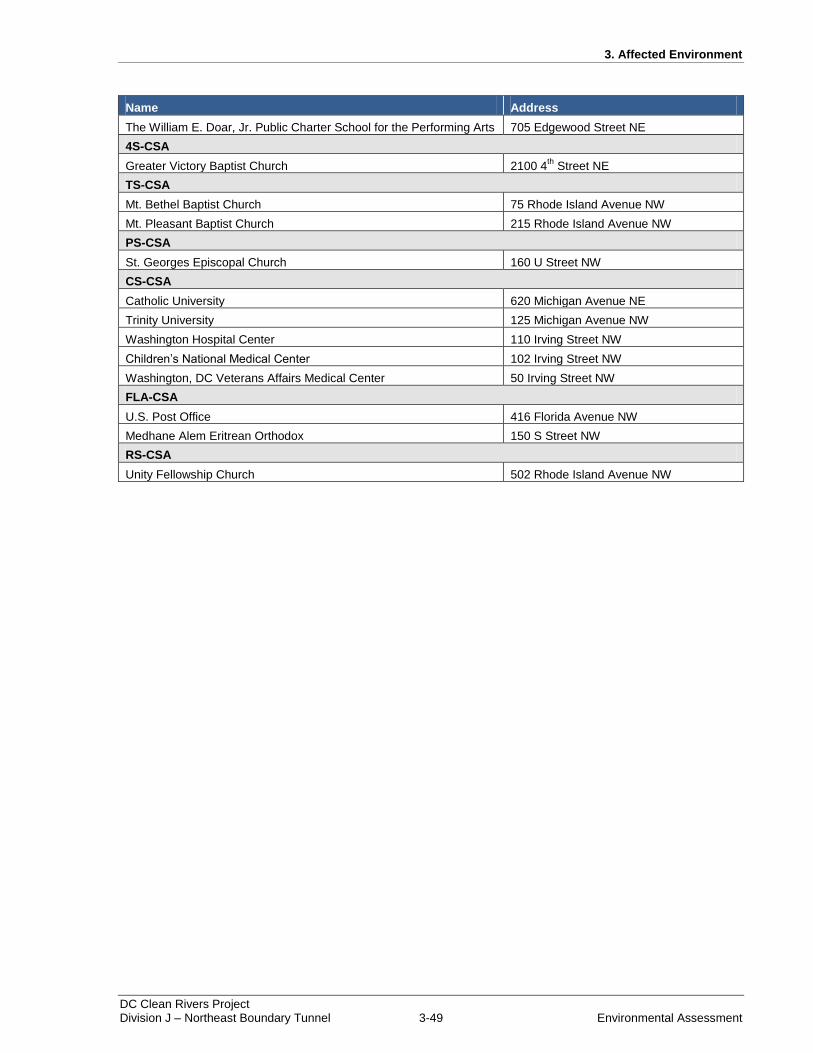
3. Affected Environment
DC Clean Rivers Project Division J – Northeast Boundary Tunnel 3-49 Environmental Assessment
Name Address
The William E. Doar, Jr. Public Charter School for the Performing Arts 705 Edgewood Street NE
4S-CSA
Greater Victory Baptist Church 2100 4th
Street NE
TS-CSA
Mt. Bethel Baptist Church 75 Rhode Island Avenue NW
Mt. Pleasant Baptist Church 215 Rhode Island Avenue NW
PS-CSA
St. Georges Episcopal Church 160 U Street NW
CS-CSA
Catholic University 620 Michigan Avenue NE
Trinity University 125 Michigan Avenue NW
Washington Hospital Center 110 Irving Street NW
Children’s National Medical Center 102 Irving Street NW
Washington, DC Veterans Affairs Medical Center 50 Irving Street NW
FLA-CSA
U.S. Post Office 416 Florida Avenue NW
Medhane Alem Eritrean Orthodox 150 S Street NW
RS-CSA
Unity Fellowship Church 502 Rhode Island Avenue NW
3. Affected Environment
DC Clean Rivers Project Division J – Northeast Boundary Tunnel 3-50 Environmental Assessment
THIS PAGE INTENTIONALLY LEFT BLANK.
4. Environmental Consequences
DC Clean Rivers Project Division J – Northeast Boundary Tunnel 4-1 Environmental Assessment
4 ENVIRONMENTAL CONSEQUENCES
Alternatives are described in Chapter 2 of this EA. Alternative A (No Action) provides a baseline for
assessing the environmental effects of Alternative B (NEBT), the action alternative. In this EA, DC Water
has made a reasonable effort to assess the potential effects of the alternatives outlined in Chapter 2:
Alternatives. Impacts in this EA have been assessed based on preliminary project designs and similar past
projects.
This section analyzes both beneficial and adverse impacts that would result from implementing the
alternatives considered in this EA. This section also includes definitions of impact thresholds (e.g.,
negligible, minor, moderate, and major), methods used to analyze impacts, and the analysis methods used
for determining cumulative impacts. A summary of the environmental consequences for each alternative
is provided in Table 2-3, which can be found in “Chapter 2: Alternatives.” The resource topics presented
in this section, and the organization of the topics, correspond to the resource discussions contained in
“Chapter 3: Affected Environment.”
Direct, indirect, and cumulative impacts have been assessed in this chapter. Direct impacts are caused by
a particular action and occur at the same time and place as the action. Indirect impacts are caused by the
actions and are later in time or further removed in distance, but are still reasonably foreseeable. Impacts
described in the following chapter should be considered direct impacts unless stated otherwise.
Cumulative impacts are defined in Section 4.1, but can result from individually minor, but collectively
significant actions taking place over a period of time.
Potential impacts are described in terms of:
Intensity, the effects are negligible, minor, moderate, or major;
Type, the effects are beneficial or adverse;
Duration, the effects are short-term, lasting through construction or less than 1 year, or long-term,
lasting more than 1 year; and
Context, the effects are site specific, local, or regional.
The thresholds of change for the intensity of impacts are defined as follows:
Negligible, the impact is localized and not measureable or at the lowest level of detection;
Minor, the impact is localized and slight but detectable;
Moderate, the impact is readily apparent and appreciable; or
Major, the impact is severely adverse and highly noticeable.
At the end of each section when applicable, DC Water provides information on mitigation measures that
would be employed to help avoid, minimize, or mitigate an adverse impact on a given resource.
4.1 Cumulative Impacts Analysis Method
Cumulative impacts are defined as “the impact on the environment which results from the incremental
impact of the action when added to other past, present and reasonably foreseeable future actions
regardless of what agency or person undertakes such other actions” (40 CFR 1508.7). As stated in the
Council on Environmental Quality (CEQ) handbook, “Considering Cumulative Effects” (CEQ 1997),
cumulative impacts need to be analyzed in terms of the specific resource, ecosystem, and human

4. Environmental Consequences
DC Clean Rivers Project Division J – Northeast Boundary Tunnel 4-2 Environmental Assessment
community being affected and should focus on effects that are truly meaningful. Cumulative impacts are
considered for Alternative A and Alternative B.
Cumulative impacts were determined by combining the impacts of the proposed Action Alternative with
other past, present, and reasonably foreseeable future actions. Ongoing and reasonably foreseeable future
projects and plans in the project area are summarized in Table 4-1 and were considered in assessing
cumulative impacts.
Table 4-1: Cumulative Impacts Projects
Agency Cumulative
Impact Project Description Status
Transportation Projects
District Department of Transportation
LeDroit Park Surface Water Management Project
Short-term solutions to reduce flooding at the 600 block and 500 block of Florida Ave, NW (new catch basins and a new inlet and pipe). Affected Resources: Water Quality, Noise,
Infrastructure, Transportation
Ongoing
District Department of Transportation
Rhode Island Avenue Pedestrian Bridge (DDOT 2013)
Construction of a new pedestrian\bicycle bridge along the Metropolitan Branch Trail providing access to the Rhode Island Avenue Metro Station. Work will also include the construction of wheelchair accessible ramps, stairs, and landings, as well as the addition of lighting and landscaping elements. Affected Environment: Soils and Topography,
Noise, Transportation
Commenced 2013
District Department of Transportation
East Capitol Street Bridge (DDOT 2013a)
Rehabilitation of the East Capital Street Bridge (Whitney Young Memorial Bridge). Affected Environment: Water Quality, Noise,
Transportation
Future
District Department of Transportation
Reconstruction of Florida Avenue, NW (DDOT 2013a)
Reconstruction of Florida Ave. NW from 9th
Street to Sherman Avenue. Affected Environment: Air Quality, Noise,
Transportation
Future
Washington Metropolitan Area Transit Authority
Planned joint development sites (WMATA 2013)
The Washington Metropolitan Area Transit Authority is planning joint development at the Brookland-CUA Metro Station located near the Michigan Avenue bridge by 9
th Street, NE and 10
th Street, NE.
Development will consist of adding residential and commercial space to replace a Kiss and Ride facility. Development will cover two parcels. Affected Resources: Soils and Topography, Noise,
Land Use, Transportation
Approved 2009
National Capital Planning Commission
West Virginia Avenue NE Highway Plan Amendment (NCPC 2010)
A highway plan amendment was proposed for West Virginia Avenue, NE between Mt. Olivet Road, NE and Fenwick Street, NE. This amendment facilitates the redevelopment of seven lots for the purposes of affordable housings as part of the Ivy City Special Demonstration Project. Affected Environment: Soils and Topography,
Noise, Land Use, Transportation
Proposed
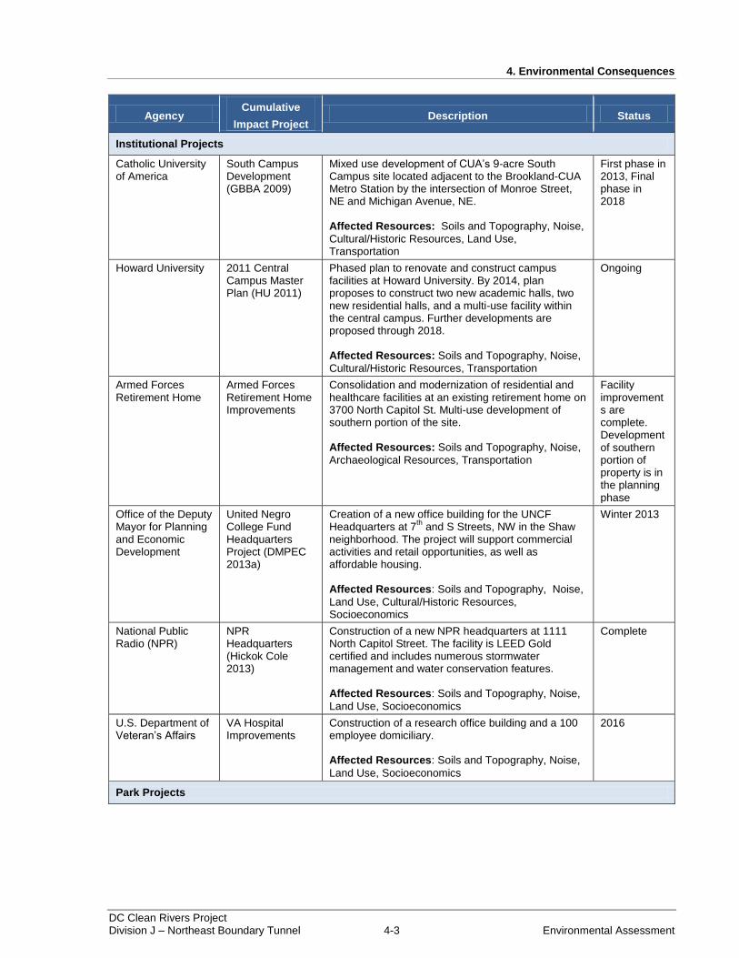
4. Environmental Consequences
DC Clean Rivers Project Division J – Northeast Boundary Tunnel 4-3 Environmental Assessment
Agency Cumulative
Impact Project Description Status
Institutional Projects
Catholic University of America
South Campus Development (GBBA 2009)
Mixed use development of CUA’s 9-acre South Campus site located adjacent to the Brookland-CUA Metro Station by the intersection of Monroe Street, NE and Michigan Avenue, NE. Affected Resources: Soils and Topography, Noise,
Cultural/Historic Resources, Land Use, Transportation
First phase in 2013, Final phase in 2018
Howard University 2011 Central Campus Master Plan (HU 2011)
Phased plan to renovate and construct campus facilities at Howard University. By 2014, plan proposes to construct two new academic halls, two new residential halls, and a multi-use facility within the central campus. Further developments are proposed through 2018. Affected Resources: Soils and Topography, Noise,
Cultural/Historic Resources, Transportation
Ongoing
Armed Forces Retirement Home
Armed Forces Retirement Home Improvements
Consolidation and modernization of residential and healthcare facilities at an existing retirement home on 3700 North Capitol St. Multi-use development of southern portion of the site. Affected Resources: Soils and Topography, Noise,
Archaeological Resources, Transportation
Facility improvements are complete. Development of southern portion of property is in the planning phase
Office of the Deputy Mayor for Planning and Economic Development
United Negro College Fund Headquarters Project (DMPEC 2013a)
Creation of a new office building for the UNCF Headquarters at 7
th and S Streets, NW in the Shaw
neighborhood. The project will support commercial activities and retail opportunities, as well as affordable housing. Affected Resources: Soils and Topography, Noise,
Land Use, Cultural/Historic Resources, Socioeconomics
Winter 2013
National Public Radio (NPR)
NPR Headquarters (Hickok Cole 2013)
Construction of a new NPR headquarters at 1111 North Capitol Street. The facility is LEED Gold certified and includes numerous stormwater management and water conservation features. Affected Resources: Soils and Topography, Noise,
Land Use, Socioeconomics
Complete
U.S. Department of Veteran’s Affairs
VA Hospital Improvements
Construction of a research office building and a 100 employee domiciliary. Affected Resources: Soils and Topography, Noise,
Land Use, Socioeconomics
2016
Park Projects

4. Environmental Consequences
DC Clean Rivers Project Division J – Northeast Boundary Tunnel 4-4 Environmental Assessment
Agency Cumulative
Impact Project Description Status
National Park Service
Anacostia Kingfisher Watertrail Master Plan and Public Access Project (NPS 2013a)
Improvements to support recreational use of the Anacostia. The proposed watertrail extends from Bladensburg, MD through Washington, DC to the Potomac River. Affected Resources: Water Quality, Land Use
Ongoing
Office of the Deputy Mayor for Planning and Economic Development
Kingman Island and Heritage Island Parks (DMPEC 2013)
Restoration of Kingman Island and Heritage Island Parks located near Benning Road, SE and RFK Stadium at the Anacostia River. New improvements will include an Environmental Education Center, walking trails, and a memorial grove. Affected Resources: Soils and Topography, Water
Quality, Land Use
First Phase 2010
Local Planning Projects
DC Office of Planning
Mid City East Plan (DCOP 2013)
Small area plan involving renewal of commercial corridors on North Capitol St, Rhode Island Ave, New Jersey Ave, New York Ave, and Florida Ave. Preservation of neighborhood character is also an objective of the Plan. Affected Resources: Cultural/Historic Resources,
Socioeconomics
Plan studies commenced in February 2013, Plan to be adopted in May 2014.
Land Development Projects
Vision McMillan Partners
Envision McMillan - Redevelopment of the McMillan Property (EM 2013)
Proposed development of the McMillan Sand Filtration Site to include new homes, offices, parks, retail stores, and cultural spaces. The project will combine historic preservation and large, high-quality open spaces with economic development that provides jobs, retail offerings, housing, and amenities to the community. Affected Resources: Soils and Topography, Noise,
Land Use, Cultural/Historic Resources, Archaeological Resources, Socioeconomics
Near Future
Office of the Deputy Mayor for Planning and Economic Development
Hill East District Redevelopment (DMPEC 2013b)
Redevelopment of 67 acres located between the eastern edge of the Capitol Hill neighborhood and the west shore of the Anacostia River into a mixed-use urban waterfront community. The waterfront community will connect the Hill East neighborhood to the Anacostia waterfront through public streets, recreational trails, and parklands. Affected Resources: Soils and Topography, Water
Quality, Air Quality, Noise, Land Use, Transportation, Socioeconomics.
Ongoing
Douglas Development Corporation
Hecht’s Warehouse Redevelopment (Douglas 2013)
Redevelopment of the Hecht Warehouse on New York Ave, NE to include retail and office space. A new garage attached to the warehouse would provide 900+ parking spaces. Affected Resources: Soils and Topography, Noise,
Land Use, Transportation, Socioeconomics
2015
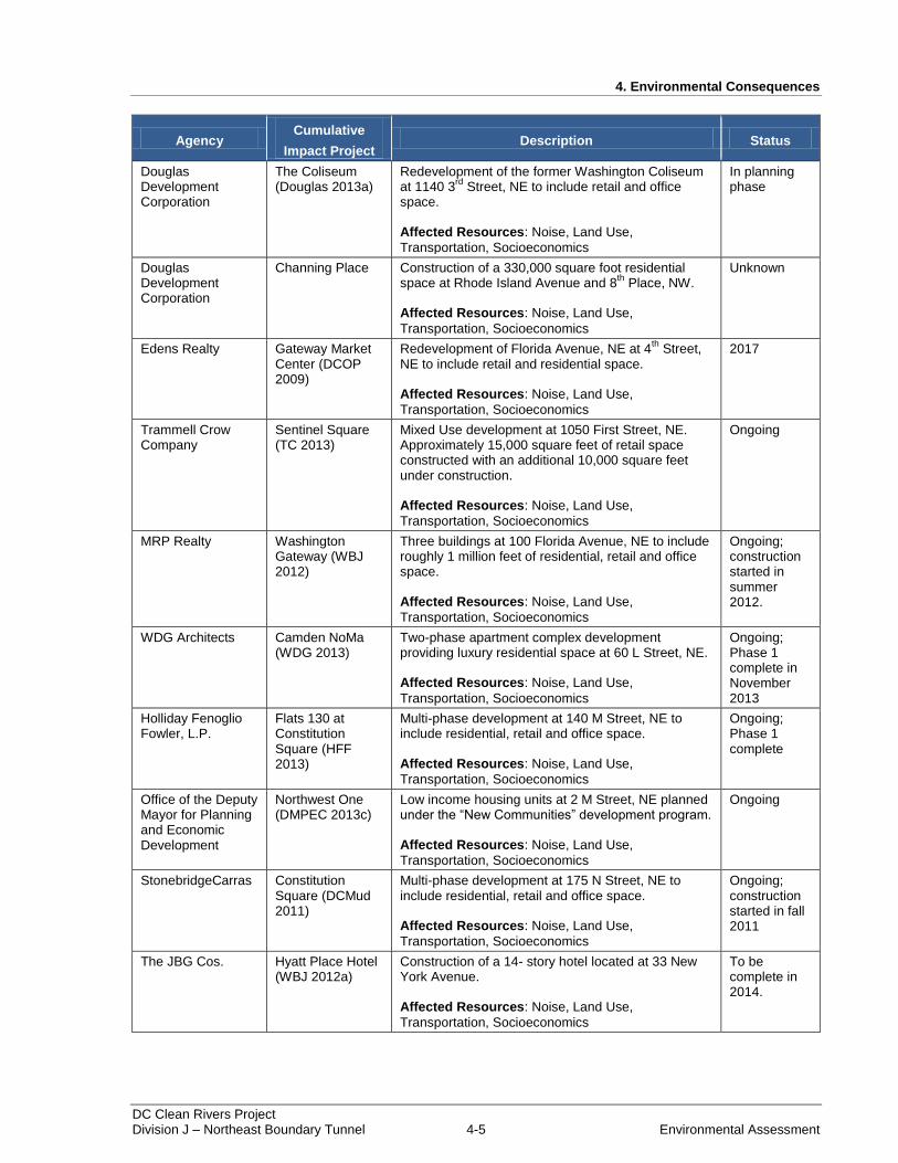
4. Environmental Consequences
DC Clean Rivers Project Division J – Northeast Boundary Tunnel 4-5 Environmental Assessment
Agency Cumulative
Impact Project Description Status
Douglas Development Corporation
The Coliseum (Douglas 2013a)
Redevelopment of the former Washington Coliseum at 1140 3
rd Street, NE to include retail and office
space. Affected Resources: Noise, Land Use,
Transportation, Socioeconomics
In planning phase
Douglas Development Corporation
Channing Place Construction of a 330,000 square foot residential space at Rhode Island Avenue and 8
th Place, NW.
Affected Resources: Noise, Land Use,
Transportation, Socioeconomics
Unknown
Edens Realty Gateway Market Center (DCOP 2009)
Redevelopment of Florida Avenue, NE at 4th
Street, NE to include retail and residential space. Affected Resources: Noise, Land Use,
Transportation, Socioeconomics
2017
Trammell Crow Company
Sentinel Square (TC 2013)
Mixed Use development at 1050 First Street, NE. Approximately 15,000 square feet of retail space constructed with an additional 10,000 square feet under construction. Affected Resources: Noise, Land Use,
Transportation, Socioeconomics
Ongoing
MRP Realty Washington Gateway (WBJ 2012)
Three buildings at 100 Florida Avenue, NE to include roughly 1 million feet of residential, retail and office space. Affected Resources: Noise, Land Use,
Transportation, Socioeconomics
Ongoing; construction started in summer 2012.
WDG Architects Camden NoMa (WDG 2013)
Two-phase apartment complex development providing luxury residential space at 60 L Street, NE. Affected Resources: Noise, Land Use,
Transportation, Socioeconomics
Ongoing; Phase 1 complete in November 2013
Holliday Fenoglio Fowler, L.P.
Flats 130 at Constitution Square (HFF 2013)
Multi-phase development at 140 M Street, NE to include residential, retail and office space. Affected Resources: Noise, Land Use,
Transportation, Socioeconomics
Ongoing; Phase 1 complete
Office of the Deputy Mayor for Planning and Economic Development
Northwest One (DMPEC 2013c)
Low income housing units at 2 M Street, NE planned under the “New Communities” development program. Affected Resources: Noise, Land Use,
Transportation, Socioeconomics
Ongoing
StonebridgeCarras Constitution Square (DCMud 2011)
Multi-phase development at 175 N Street, NE to include residential, retail and office space. Affected Resources: Noise, Land Use,
Transportation, Socioeconomics
Ongoing; construction started in fall 2011
The JBG Cos. Hyatt Place Hotel (WBJ 2012a)
Construction of a 14- story hotel located at 33 New York Avenue. Affected Resources: Noise, Land Use,
Transportation, Socioeconomics
To be complete in 2014.

4. Environmental Consequences
DC Clean Rivers Project Division J – Northeast Boundary Tunnel 4-6 Environmental Assessment
Agency Cumulative
Impact Project Description Status
Archstone 110 K Street NE (JSD 2013)
Construction of residential and retail space on the site of a former bus repair facility at the northeast corner of First and K Streets, NE. Affected Resources: Noise, Land Use,
Transportation, Socioeconomics
Ongoing; construction started in 2012
4.2 Soils and Topography
4.2.1 Alternative A – No Action Alternative
Under Alternative A, the NEBT and associated structures would not be constructed resulting in no
impacts to soils and topography.
4.2.1.1 Cumulative Impacts
Alternative A would have no impacts on soils and topography; therefore, there would be no cumulative
impacts.
4.2.2 Alternative B – Northeast Boundary Tunnel (NEBT)
Under Alternative B, excavation of the NEBT from the CSO 019-CSA along with the construction of the
proposed structures, diversion and ventilation control facilities would require removal of soils. Excavated
soils would be transported to permitted soil disposal sites or appropriately classified landfills. Any
contaminated soil encountered during construction would be disposed of in accordance with Federal and
District laws and regulations.
Construction staging areas and access routes would be designed to mitigate impacts outside of the project
areas. Erosion and sediment control measures such as silt fencing, hay bales, diversion channels and
berms, temporary stormwater basins, and temporary inlet protections would be implemented to prevent
unintended soil migration. Once construction is complete, the project contractor would restore excavated
areas to preconstruction surface conditions. Under Alternative B, erosion and sediment control measures
would be necessary and would likely be successful. However, based on the considerable volume of
excavated materials to be removed, short-term minor adverse impacts to soils would be unavoidable.
The WS-CSA contains soils classified as prime farmland soils; however, the site would not be subject to
the provisions of the Farmland Protection Policy Act because it is zoned for urban use. An area identified
as prime farmland must be used for producing food or fiber or must be available for those uses. Thus,
urban and built-up land and water areas do not meet the criteria for prime farmland. The prime farmland
soil present on the site is Matapeake silt loam, 0 to 8 percent slopes. No hydric soils are present within the
project area.
The WS-CSA slopes from the north to the south (and contains slopes between 0 and 40 percent). In order
to construct the proposed junction shaft and ventilation control facility, the existing site would be graded
to a flat surface. Grading the site would require that a retaining wall be constructed at the northern edge of
the site to stabilize the forested area that buffers the Department of Public Works / District Department of
Transportation facility from the residential properties located along W Street, NE. Although the proposed
actions at the WS-CSA would result in permanent impacts to soils and topography, the effects on
surrounding areas would be minimal. The forested hilltop separating homes on W Street, NE and the CSA
would be preserved, which would maintain the visual character of W Street, NE.
4. Environmental Consequences
DC Clean Rivers Project Division J – Northeast Boundary Tunnel 4-7 Environmental Assessment
Overall, the proposed action under Alternative B, including installation of the proposed structures,
diversion and ventilation control facilities, would primarily be constructed below grade and changes to
project area topography would not be noticeable with the exception of activities at the WS-CSA.
Similarly, the permanent removal of excavated materials from the project area would not result in
noticeable changes to surface conditions. Based on these factors, Alternative B would result in long-term
minor adverse impacts to soils and topography.
4.2.2.1 Cumulative Impacts
Development projects in the vicinity of the proposed project were reviewed to determine potential
cumulative impacts to soils and topography. In general, development projects proposed in the study area
would involve construction and would have long-term minor adverse impacts to soils. Development
associated with the Armed Forces Retirement Home, the Howard University Master Plan, the McMillan
Sand Filtration Site, Kingman Island and Heritage Island Parks, CUA’s South Campus, and the
Washington Metropolitan Area Transit Authority planned joint development sites would involve earth
moving and would require erosion and sediment controls. Under Alternative B, long-term impacts of the
proposed project on soils would be minor. As a result, when combined with the effects of nearby
development projects, there would be long-term minor adverse cumulative impacts to soils and
topography.
4.2.2.2 Mitigation Measures
The following mitigation measures would be implemented to mitigate impacts to soils and topography:
Excavated soils would be removed from the CSAs in an expedient manner.
Prior to removal, temporary storage of soils at the CSAs would involve protective measures to prevent
runoff.
Exposed soils would be stabilized and planted with vegetation following completion of construction
activities.
Where appropriate, trenchless technologies would be utilized in order to minimize impacts.
4.3 Geology and Geologic Hazards
4.3.1 Alternative A – No Action Alternative
Under Alternative A, geologic conditions would not be affected. The middle Pleistocene and lower
Cretaceous sediments underlying the study area would subside naturally, but the subsidence would be
minimal and would only be measureable over a long time period. As a result, there would be no impacts
to geology under Alternative A.
4.3.1.1 Cumulative Impacts
Alternative A would have no impacts on geology; therefore, there would be no cumulative impacts.
4.3.2 Alternative B – Northeast Boundary Tunnel (NEBT)
Under Alternative B, construction of the NEBT would require removal of subsurface materials. The
tunnel and adits would be constructed below the surface within the Potomac Group geologic layer.
Diversion and ventilation control facilities would be constructed in areas of middle Pleistocene deposits
and artificial fill materials. During tunnel construction, subsurface materials would be removed at the
4. Environmental Consequences
DC Clean Rivers Project Division J – Northeast Boundary Tunnel 4-8 Environmental Assessment
CSO 019-CSA. Approximately 550,000 cubic yards of material would be removed to construct the
tunnel.
Construction of the proposed structures, diversion and ventilation control facilities, would require
excavation that could result in minor subsidence in localized areas. To mitigate the effect of subsidence,
the proposed facilities have been kept as far from existing structures and utilities as practicable, and
construction means and methods have been specified to minimize the potential for subsidence.
Additionally, preconstruction surveys would be performed to identify sensitive structures and utilities.
During construction, subsurface materials and sensitive utilities and structures would be instrumented and
monitored. If conditions indicate the potential for unacceptable subsidence, ground improvement
measures would be implemented to prevent or reduce subsidence to an acceptable amount. Based on
these considerations, there would be short-term minor adverse impacts to geology under Alternative B.
Impacts to geology associated with tunneling activities deep below the surface would be negligible. Based
on the compression of the middle Pleistocene deposits and the Potomac Group layer, subsurface materials
are expected to remain in place during tunneling. Following construction, the tunnel and supporting
infrastructure would be inspected periodically to verify the integrity of structures and to check for
groundwater or sediment intrusion. Based on the density of the Potomac Group layer, and the low level of
seismic activity in the area, geologic hazards associated with the proposed tunnel are expected to be
minimal. Therefore, there would be long-term negligible adverse impacts under Alternative B.
4.3.2.1 Cumulative Impacts
Cumulative impacts projects in the vicinity of the Northeast Boundary drainage area include
transportation, park-related, land use planning, and land development projects. Among the projects
identified in Table 4-1, no significant impacts to local geology were identified. Large scale developments
such as institutional buildings and residential towers would require construction activities beneath the
ground surface; however, subsurface construction would have minimal impacts on local geology. Based
on the relatively stable geologic resources to be built upon and preconstruction testing to ensure stability,
the effects of cumulative impacts projects on local geology would be negligible. As a result, there would
be long-term negligible adverse cumulative impacts when the NEBT is added to past, present, and future
projects in the area.
4.3.2.2 Mitigation Measures
The following mitigation measures would be implemented to mitigate impacts to geology:
Construction means and methods would be specified that would minimize subsidence.
Geotechnical borings would take place to determine site specific conditions at the proposed CSAs.
Subsurface monitoring would be carried out during construction to identify potential adverse
conditions.
Ground improvement measures would be implemented around the proposed structures to stabilize
soils prone to unacceptable subsidence or instability.
4. Environmental Consequences
DC Clean Rivers Project Division J – Northeast Boundary Tunnel 4-9 Environmental Assessment
4.4 Groundwater and Hydrology
4.4.1 Alternative A – No Action Alternative
Under Alternative A, groundwater and hydrology in the study area would not be affected. There would be
no impacts to regional groundwater aquifers, and there would be no impacts to unconfined groundwater
resources.
4.4.1.1 Cumulative Impacts
Under Alternative A, there would be no impacts to groundwater or hydrology. Therefore, there would be
no cumulative impacts.
4.4.2 Alternative B – Northeast Boundary Tunnel (NEBT)
Under Alternative B, the NEBT would be constructed below the surface in areas of relatively unconfined
groundwater. Regional deep water aquifers would be well below the proposed tunnel, at approximately
700 feet below the surface.
During construction, dewatering activities would be required at the CSAs to maintain workable areas for
personnel and equipment. Dewatering would temporarily lower the water table in localized areas
surrounding the proposed diversion and ventilation facilities. Dewatering would involve pumping
groundwater to existing combined sewers during low flow periods in the system.
Based on the absence of surface water bodies in proximity to CSAs, dewatering activities would be
unlikely to affect surface water resources. However, lowering of the water table could result in minor
subsidence of the ground. To mitigate the effect of subsidence, the proposed facilities have been kept as
far from existing structures and utilities as practicable, and construction means and methods have been
specified to minimize the potential for subsidence. Additionally, preconstruction surveys would be
performed to identify sensitive structures and utilities. During construction, subsurface materials and
sensitive utilities and structures would be instrumented and monitored. If conditions indicate the potential
for unacceptable subsidence, ground improvement measures would be implemented to prevent or reduce
subsidence to an acceptable amount. Based on these considerations, there would be short-term minor
adverse impacts to groundwater and hydrology under Alternative B.
Once construction is complete, groundwater levels in proximity to CSAs would generally return to
preconstruction conditions. Throughout the project area there would be a slight increase in impervious
land due to the construction of various tunnel components at the ground surface. At the WS-CSA, a
ventilation control facility and small parking lot are proposed. The impervious areas would prevent
groundwater recharge to a small extent, but long-term effects associated with the structures would not be
noticeable. As a result, there would be long-term negligible adverse impacts under Alternative B, because
the impacts to groundwater and hydrology would only be recognized at the lowest level of detection.
4.4.2.1 Cumulative Impacts
Among the projects listed in Table 4-1, there were no projects identified which would have sizeable
effects on groundwater or hydrology. Cumulative impacts projects would result in slight, localized effects
on groundwater, due to the construction of impervious surfaces. Proposed land development activities
would include buildings, parking garages, and driveways which would increase the imperviousness of the
cumulative impact study area. Consequently, there would be reductions in groundwater recharge.
Although there would be localized effects on groundwater, impacts would be minimal. Reductions in
groundwater recharge would not be noticeable, based on the urban setting of the area. In addition, projects
4. Environmental Consequences
DC Clean Rivers Project Division J – Northeast Boundary Tunnel 4-10 Environmental Assessment
such as the Hill East District Redevelopment, the Coliseum, and the Gateway Market Center are proposed
in areas that have been previously developed or disturbed. Redevelopment of these sites could enhance
groundwater recharge through environmental site designs and the use of best management practices.
Based on these considerations, the effects of cumulative impacts projects on groundwater and hydrology
would be negligible. When combined with the impacts of Alternative B, there would be long-term
negligible adverse cumulative impacts.
4.4.2.2 Mitigation Measures
The following mitigation measures would be implemented to minimize impacts to groundwater and
hydrology:
Construction means and methods would be specified that would minimize subsidence.
Pre- and post-construction surveys would be performed on structures within the zone of influence to
accurately determine impacts related to construction. In addition, the surveys would identify
additional mitigation measures required to protect sensitive structures.
Geotechnical borings would take place to determine site specific conditions at proposed CSAs.
Dewatering operations would be monitored in order to identify the development of unacceptable
conditions.
Ground improvement measures would be implemented if dewatering practices result in the potential
for subsidence.
4.5 Water Quality
4.5.1 Alternative A – No Action Alternative
Alternative A would result in the continued combined sewer flooding of the Northeast Boundary drainage
area and CSOs would continue to be discharged to the Anacostia River. Therefore, Alternative A would
result in short-term and long-term moderate to major adverse impacts to water quality.
4.5.1.1 Cumulative Impacts
Overall, cumulative impacts projects listed in Table 4-1 would increase impervious area within the
Northeast Boundary drainage area, thereby increasing stormwater runoff to a collection system that is
currently undersized. Since Alternative A proposes to maintain the existing system and not increase
capacity to meet DC Water standards, the frequency of flood events would increase. In addition, CSO
discharges would increase and continue to contribute to the water quality impairment of the Anacostia
River and violate the terms of the Federal Consent Decree. Consequently, Alternative A would result in
short-term and long-term major adverse impacts to water quality.
4.5.2 Alternative B – Northeast Boundary Tunnel (NEBT)
Under Alternative B, construction activities would involve earth moving and would result in loose soils
and sediments. To prevent water quality impacts associated with soil runoff and erosion, approved erosion
and sediment control methods would be employed at the CSAs. Methods to retain soils could include the
use of silt fencing, coffer dams, hay bales, diversion channels and berms, temporary stormwater basins,
and temporary inlet protections. All erosion control practices would be reviewed and approved by the
District Department of Environment prior to implementation. In addition, CSAs would be monitored
during construction to ensure effectiveness of erosion and sediment control devices.
4. Environmental Consequences
DC Clean Rivers Project Division J – Northeast Boundary Tunnel 4-11 Environmental Assessment
Construction at the CSAs would also involve dewatering practices. Dewatering would recover sediment
laden waters from underground work areas. To prevent the sediment laden waters from reaching streams,
the waters would be pumped to existing combined sewers during low flow periods in the system. From
there, the waters would be directed to Blue Plains for treatment. Discharges to the existing combined
system would be permitted by the District Department of Environment under a Temporary Discharge
Authorization (TDA) Permit. Permit conditions would require sampling to determine pollutant
constituents of recovered groundwater.
If waters containing one or more constituents at or above current DC Water discharge standards (as listed
in 21 DCMR §1501) were encountered during dewatering, an alternative disposal method would be
implemented. Alternatives could include offsite disposal, or onsite wastewater treatment. Prior to any
onsite wastewater treatment, DC Water would outline treatment procedures in a Water Treatment Plan,
which would be approved by the District Department of Environment.
Based on the above considerations, construction activities at the CSAs would have short-term negligible
adverse impacts on water quality. Temporary site controls during earth moving and dewatering activities
would be relatively simple to implement and likely to succeed. In the long-term, the NEBT would provide
storage for storm flows and sewer flows in the project area. There would be significantly less CSO
discharge to the Anacostia River; therefore, there would be substantial long-term water quality benefits.
4.5.2.1 Cumulative Impacts
The implementation of Alternative B would provide an increase in system capacity necessary to convey
the stormwater runoff generated from the additional impervious areas resulting from the developments
listed in Table 4-1. The NEBT would increase the capacity of the Northeast Boundary drainage area
collection system, mitigating the risk of sewage flooding to grade and basements. Additionally, the
implementation of Alternative B would mitigate the impacts of CSO discharges on Anacostia River water
quality. Therefore, there would be a long-term beneficial cumulative impact on water quality.
4.5.2.2 Mitigation Measures
The following mitigation measures would be implemented to mitigate impacts to water quality:
Site controls would be monitored to ensure effectiveness and confirm environmental quality
compliance at CSAs.
Dewatering practices would include conveyance of sediment-laden groundwater to Blue Plains.
Polluted waters recovered from the ground would be properly disposed in accordance with District
Department of Environment standards.
4.6 Air Quality
4.6.1 Alternative A – No Action Alternative
Under Alternative A, no impacts to air quality would occur because the NEBT would not be constructed.
4.6.1.1 Cumulative Impacts
Under Alternative A, there would be no impacts to air quality. Therefore, there would be no cumulative
impacts.
4. Environmental Consequences
DC Clean Rivers Project Division J – Northeast Boundary Tunnel 4-12 Environmental Assessment
4.6.2 Alternative B – Northeast Boundary Tunnel (NEBT)
Under Alternative B, the construction of the NEBT and associated structures would have effects on local
air quality from construction equipment and generator emissions; fugitive dust from demolition activities;
tunnel boring; and the numerous additional vehicular trips to and from the site by construction workers
and equipment. To minimize the release of airborne pollutants, appropriate best management practices
would be used during construction. Such practices could include, but would not be limited to, the use of
water and dust barriers to control airborne dust during construction activities and the use of temporary
vegetative cover and/or barriers on inactive areas. The project contractor would be required to develop,
implement, and maintain compliance with a dust control plan throughout the construction process. To
mitigate the effects of emissions, the project contractor would minimize equipment idling times.
Stationary emissions sources would be distanced from each other and equipment would be run separately
to the extent feasible. In accordance with the District’s Air Pollution Control Act, activities related to
construction and demolition, which are likely to create fugitive dust, and engine emissions, would be
subject to District Department of the Environment Air Quality Division review and oversight.
Generators could be used to facilitate construction activities at the CSAs. Generators to power
construction equipment would be compliant with USEPA’s Tier 4 emission standards for non-road diesel
engines. Modeling performed in accordance with current USEPA guidance demonstrates that emissions
of Tier 4 compliant generators meet ambient air quality standards applicable to the District. In the event
that natural gas powered generators are utilized at the CSAs, equipment and emissions would be
compliant with EPA standards and requirements for large, nonroad spark ignition engines (set forth in 40
CFR 1048). To prevent odorous emissions from being discharged to the surface during the construction of
the diversion chambers, temporary odor control would be implemented at the construction sites. The first
level of protection to control odorous emissions to grade is to keep odors contained within the existing
conduit or proposed structure. If odors are unable to be contained, a second level of protection would be
utilized to withdraw and treat fugitive odors prior reaching the surface. An example of this would be an
active carbon adsorption system that would pull odorous emissions and maintain a negative pressure in
the existing conduit or structure.
Infrastructure at the proposed CSAs under Alternative B would include an above-ground ventilation
control facility at the WS-CSA and below-grade ventilation control facilities at the MOR-CSA, CS-CSA
and RS-CSA. These facilities would control air within the tunnel system during operations. Air control
would primarily involve the use of counterbalanced backdraft dampers to control the movement of air
into and out of the tunnel system. The dampers would remain closed during dry weather periods,
restricting air movement from the tunnel system to the surface. During storm events, the dampers would
open to allow the tunnel system to vent as it fills with captured combined sewer flows. Once flows to the
tunnel subside, the dampers would close again to restrict air movement from the tunnel to the surface.
Additional controls at the ventilation control facilities would be employed to capture fugitive odor
emissions from the tunnel. Common technologies to control odor emissions include the use of treatment
systems utilizing activated carbon.
In sum, construction activities under Alternative B would generate temporary air emissions and dust that
would contribute to impacts on air quality. Based on the proposed mitigation measures to minimize
detrimental effects, there would be short-term minor adverse impacts. Operation of the tunnel system and
associated structures would have minor effects on air quality. The tunnels are designed to be empty most
of the time and would therefore have a negligible impact on air quality. When the tunnel is filling or
emptying, ventilation control structures will allow exchange of air from the tunnel to areas above
ground. Even under these conditions, air exchange would only be noticeable during heavy storm periods.
The noticeable effects of ventilation from the tunnel would be scarce over the course of a year. Therefore,
4. Environmental Consequences
DC Clean Rivers Project Division J – Northeast Boundary Tunnel 4-13 Environmental Assessment
there would be long-term minor adverse impacts to air quality, similar to the impacts from the existing
sewer system in the District.
4.6.2.1 Cumulative Impacts
Cumulative impacts projects were reviewed to determine past, present and reasonably foreseeable future
impacts on air quality in the Northeast Boundary sewershed. Projects identified as having adverse effects
on air quality include the reconstruction of Florida Avenue, NW and the redevelopment of the Hill East
District. Both projects would involve road construction which would have temporary effects on air quality
that would be readily apparent. Other projects including proposed mixed use developments, institutional
buildings and bridge improvements would also have temporary effects due to use of construction
equipment. No long-term impacts were identified.
Based on the extensive amount of construction taking place in the Northeast Boundary sewershed, minor
impacts to air quality would be possible. During construction, Alternative B would also result in minor
adverse impacts to air quality. Therefore, there would be minor adverse cumulative impacts under the
implementation of Alternative B and cumulative impacts projects, but the impacts would be limited to
construction periods.
4.6.2.2 Mitigation Measures
The following mitigation measures would be implemented to minimize impacts to air quality:
A dust control plan would be drafted and adhered to during construction activities, which could
include water spray dust control measures and barriers to prevent dust migration.
Equipment idling times would be limited to the extent possible.
Stationary emissions sources would be distanced from one another and run separately to the extent
feasible.
Dampers at the ventilation control facilities would restrict air movement from the tunnel.
Minor impacts associated with fugitive odors would be mitigated through the use of odor control
systems.
Inspections would take place to confirm environmental quality compliance at CSAs.
4.7 Noise and Vibration
4.7.1 Alternative A – No Action Alternative
Under Alternative A, no impacts to noise-sensitive receptors such as local residences and businesses
would occur and no construction related vibrations would be generated.
4.7.1.1 Cumulative Impacts
Under Alternative A, there would be no noise or vibration impacts. Therefore, there would be no
cumulative impacts.
4. Environmental Consequences
DC Clean Rivers Project Division J – Northeast Boundary Tunnel 4-14 Environmental Assessment
4.7.2 Alternative B – Northeast Boundary Tunnel (NEBT)
4.7.2.1 Noise
Per DC regulations, daytime (7:00 a.m. to 7:00 p.m.) construction noise levels cannot exceed 80 dB at a
residential property (20 DCMR §2802). Under Alternative B, construction and hauling of materials would
occur in the hours identified in Table 2-2. Use of above-ground construction noise-generating equipment
is needed for the project, which could include trailer-mounted diesel power generators, cranes, diesel
powered light sources, portable generators, dump trucks, etc. DC Water would ensure that all efforts be
made by the contractor to minimize equipment noise levels during construction.
During procurement of project service providers, DC Water would specify noise mitigation measures to
be employed by contractors. DC Water would ensure that contractors minimize the effects of equipment
noise on sensitive receptors such as residences, childcare facilities, and churches through mitigation with
temporary noise barriers as the most common option. DC Water analyzed several potential mitigation
measures with temporary noise barriers as the most common options. Sound absorbing fabric or other
noise abating equipment would be arranged around CSAs as appropriate. Additional mitigation measures
used to reduce noise levels from construction equipment could include, but would not be limited to
maintaining equipment mufflers; limiting the number and duration of idling equipment; locating loud
construction equipment as far from sensitive-receptors as possible; scheduling construction events to
reduce nighttime noise; and monitoring construction noise levels to confirm that noise levels are
minimized at sensitive receptors adjacent to project areas such as residences, childcare facilities, and
churches.
Under Alternative B, temporary increases in noise levels within the immediate vicinity of CSAs would
occur during construction. Noise-generating construction equipment would impact sensitive receptors.
Mitigation measures would be used by the contractor to reduce noise to the greatest extent possible.
Therefore, a short-term moderate adverse impact would occur to residents, businesses, and other
sensitive-receptors adjacent to the CSAs.
Operation of the tunnel system would require intermittent use of the proposed MOR-CSA, WS-CSA, CS-
CSA, and RS-CSA ventilation control facilities. The sound levels generated by similar facilities were
studied by DC Water and found not to exceed existing background noise levels typical of urban
environments. Additionally, noise-generating equipment at all but the WS-CSA would be located in
below-grade vaults. Therefore, adverse impacts to adjacent residents and businesses during operation of
the ventilation control facilities are expected to be negligible.
4.7.2.2 Vibration
Under Alternative B, vibrations caused by construction activities would be above ambient levels in the
neighborhoods. Alternative B would result in ground vibrations from the construction of proposed tunnel,
structures, diversion and ventilation control facilities. Construction activities such as demolition,
excavation, shoring, and material transport would cause vibrations associated with proposed structures,
diversion and ventilation control facilities. Vibrations associated with tunnel construction would be
caused by the action of the TBM cutterhead, and by the jointed track used to move materials to and away
from the tunnel face.
Several strategies would be implemented to control vibration during construction. Project planning would
involve the selection of pre-approved District haul routes. Additionally, construction means and methods
would be specified that would minimize vibrations. To reduce vibration associated with tunnel
construction, efforts would be made to provide matched profile rails and tight rail joints. In general, the

4. Environmental Consequences
DC Clean Rivers Project Division J – Northeast Boundary Tunnel 4-15 Environmental Assessment
noticeable vibrations produced by the TBM would be temporary and may only be detectable at points
along the alignment for a few days. Monitoring devices would be employed at sensitive receptors to
ensure contract compliance. Therefore, during construction there would be short-term minor adverse
impacts to sensitive receptors near the sources of vibration.
There would be no anticipated vibrations created by the operation of the NEBT, therefore, there would be
no long-term impacts following construction.
4.7.2.3 Cumulative Impacts
Development projects (see Table 4-1) in the vicinity of the proposed project were reviewed to determine
potential cumulative impacts to sensitive receptors from noise and vibrations. Development associated
with the Armed Forces Retirement Home, the Howard University Master Plan, the Bloomingdale Surface
Water Management Project, CUA’s South Campus Development, the Washington Metropolitan Area
Transit Authority planned joint development sites, the Hill East District Redevelopment, and the United
Negro College Fund Headquarters Project would result in various levels of noise due to construction or
renovation of facilities and infrastructure, resulting in short-term levels that may exceed DCMR noise
limits. In addition, the increased development could increase ambient noise levels in the project study
area following construction. Similarly, the NEBT project would result in short-term moderate adverse
impacts to sensitive receptors due to noise caused by construction activities. Therefore, there would be
short-term moderate adverse cumulative impacts when the noise impacts of Alternative B are combined
with the noise impacts of other development projects. Noise impacts associated with the operation of the
ventilation control facilities would contribute negligibly to overall cumulative noise impacts associated
with past, present, and future development in the study area.
Disruptions caused by vibrations were also considered among the cumulative impacts projects. Vibrations
would result from construction of the previously mentioned projects, and short-term effects could be
noticeable. The effects of vibrations would be limited to localized areas near construction sites and would
be unlikely to interfere with activities in the surrounding neighborhoods. However, vibrations would be
above ambient conditions, which would result in minor impacts. Alternative B would contribute to the
overall short-term effects of development projects; therefore there would be short-term minor adverse
cumulative impacts.
4.7.2.4 Mitigation Measures
The following mitigation measures would be implemented to minimize impacts to noise and vibration:
Construction means and methods would be specified that would minimize noise and vibration.
Noise barriers would be arranged around CSAs as practicable when working near sensitive receptors.
Equipment mufflers would be maintained.
The number and duration of idling equipment would be limited.
Loud construction equipment would be located as far from sensitive receptors as possible.
Construction activities would be scheduled to reduce nighttime noise.
Construction noise levels would be monitored to confirm that noise levels are minimized at sensitive
receptors adjacent to project areas such as residences, businesses and churches.
In addition to noise levels, DC Water would monitor vibration levels during construction periods in
order to mitigate potential impacts.
4. Environmental Consequences
DC Clean Rivers Project Division J – Northeast Boundary Tunnel 4-16 Environmental Assessment
4.8 Land Use and Zoning
4.8.1 Alternative A – No Action Alternative
Under Alternative A, no impacts to land use and zoning would occur because the NEBT would not be
constructed.
4.8.1.1 Cumulative Impacts
Under Alternative A, there would be no impacts to land use or zoning. Therefore, there would be no
cumulative impacts.
4.8.2 Alternative B – Northeast Boundary Tunnel (NEBT)
Under Alternative B, there would be no change in land use designation at any of the CSAs. At the WS-
CSA, the proposed project would result in a change in use from open space to use as a ventilation control
facility. The proposed use at the WS-CSA is consistent with the current industrial land use designation
(see Figure 3-5) as well as the future production, distribution, and repair designation as presented in the
District of Columbia Land Use Plan (see Figure 3-7). As described in the Plan, the future land use
designation (production, distribution, and repair) allows for “…utility activities which may require
substantial buffering from noise, air pollution, and light sensitive uses such as housing (DCOP 2012).”
With the exception of proposed activities at the WS-CSA, land use in the project area would return to
preconstruction conditions following construction. Therefore, the project would result in short-term and
long-term changes to land use at the WS-CSA and no change to land use designation.
Zoning in the project area consists of residential and commercial zones with varying characteristics. No
modification of existing zoning would be required by the project.
4.8.2.1 Cumulative Impacts
Since the implementation of Alternative B does not change the land use designation or zoning of the
proposed areas of construction, no cumulative impacts to land use or zoning would occur.
4.9 Utilities/Infrastructure
4.9.1 Alternative A – No Action Alternative
Under Alternative A, combined sewer flooding would continue during storm events resulting in damages
to public and private property. Based on the potential for utility and infrastructure damage continuing into
the future, there would be long-term moderate adverse impacts under Alternative A.
4.9.1.1 Cumulative Impacts
New facilities, as listed in Table 4-1, would be connected to existing utility and infrastructure networks.
Transportation improvements, institutional buildings, mixed use developments and parks would require
utilities and infrastructure to varying degrees. Controls would be installed among the sites to meet the
requirements of newly developed sites. Controls would include sewer infrastructure, stormwater
infrastructure, and heating, ventilation and air conditioning units. System components would be unlikely
to be noticeable from outside of new facilities.
Under Alternative A, infrastructure of the Northeast Boundary sewershed would generally remain the
same. Proposed projects in the cumulative impact study area would connect with the existing combined

4. Environmental Consequences
DC Clean Rivers Project Division J – Northeast Boundary Tunnel 4-17 Environmental Assessment
sewer system to convey wastewater and stormwater offsite. Consequently, combined sewer flooding in
the Northeast Boundary sewershed would increase, due to the additional flows received by the system.
Due to the potential for more frequent and more severe combined sewer flooding, there would be long-
term moderate adverse cumulative impacts under Alternative A.
4.9.2 Alternative B – Northeast Boundary Tunnel (NEBT)
Construction of Alternative B would result in minor conflicts with buried and/or overhead utilities in the
proposed project area. Prior to staging, all buried utilities would be marked in the field by a utility locator.
Where utilities come into conflict with proposed construction activities, utility relocation would be
necessary. Utility relocation could involve temporary interruptions to electric or natural gas delivery to
residents in the proposed project area. In most situations, relocations would be performed by contractors
affiliated with the utility owners. To reduce the impacts of service interruptions, residents would be
notified in advance of relocation. It is anticipated that most relocations would be completed in advance of
construction to avoid unexpected interruptions in service and to accelerate project construction. Based on
the temporary short-term interruptions required by the proposed action, there would be short-term minor
adverse impacts from utility relocation.
Once constructed, the NEBT would provide increased collection system capacity, which would mitigate
surface flooding and basement backups. Damages to utilities and infrastructure due to flooding would
also be significantly reduced. As a result, the proposed tunnel would provide long-term benefits to the
Northeast Boundary sewershed.
4.9.2.1 Cumulative Impacts
Cumulative impacts projects would involve construction of new facilities which would connect with
utilities and infrastructure in the Northeast Boundary sewershed. New facilities include transportation
improvements, institutional buildings and mixed use developments, which would require controls to
manage utility and infrastructure services. Alternative B would provide sufficient collection system
capacity to accommodate increased flows as new facilities and development occurs. As a result, there
would be no cumulative impacts.
4.9.2.2 Mitigation Measures
The following mitigation measures would be implemented to mitigate impacts to utilities and
infrastructure:
Utilities would be relocated in advance in order to mitigate risk to the construction schedule.
4.10 Cultural/Historic Resources
The NHPA is the guiding legislation for the preservation of historic properties and it establishes standards
for evaluating potential effects on historic resources. The NHPA defines "effect" as an "alteration to the
characteristics of a historic property qualifying it for inclusion in or eligibility for the National Register"
(36 CFR § 800, 16), and requires that the lead agency, in consultation with the DC Historic Preservation
Office, determine whether the effect is adverse. According to the NHPA, an "adverse effect" occurs
"when an undertaking may alter, directly or indirectly, any of the characteristics of the historic property
that qualify the property for inclusion in the National Register in a manner that would diminish the
integrity of the property's location, design, setting, materials, workmanship, feeling, or association" (36
CFR § 800, 5).
4. Environmental Consequences
DC Clean Rivers Project Division J – Northeast Boundary Tunnel 4-18 Environmental Assessment
DC Water has begun the formal DC Historic Preservation Review process that applies to designated
historic resources. The DC Historic Preservation Office, acting as the State Historic Preservation Office,
reviews projects involving Federal and District expenditures, or undertakings, regarding actions that will
affect properties that are listed on or qualify for the NRHP and the DC Inventory. As part of this process,
DC Water, acting as a government agency, is in the process of taking into account the effects of their
undertakings on properties listed or eligible for listing in the DC Inventory and/or NRHP, and to consult
with and afford the DC Historic Preservation Office a reasonable opportunity to comment.
Impacts on historic properties can take the form of physical impacts to a property, alterations to the
property’s setting, the introduction of visual or audible elements to the property, or its immediate vicinity,
or other actions. Impacts resulting from a project may or may not represent an “adverse effect” to
identified cultural resources. The criteria for adverse effect must be applied to evaluate whether a project
would result in an adverse effect to historic properties. These criteria provide a basis for determining the
project’s potential effect on historic properties.
Potential effects to historic resources include direct and indirect effects. The alteration, physical
displacement, or demolition of a resource is a direct adverse effect; changes in the use, operation or
character of a resource can be either direct or indirect effects; and changes to the visual context are
considered indirect effects. Impact thresholds for cultural resources have been defined as follows:
Negligible – The impact would be at the lowest level of detection or barely perceptible and not
measurable.
Minor – The impact would not affect the character defining features of an historic resource(s)
listed on or eligible for the National Register of Historic Places.
Moderate – The impact would alter a character defining feature(s) of an historic resource(s) but
would not diminish the integrity of the resource to the extent that its National Register listing
would be jeopardized.
Major – The impact would alter a character defining feature(s) of an historic resource(s),
diminishing the integrity of the resource to the extent that it is no longer eligible for listing on the
National Register.
4.10.1 Alternative A – No Action Alternative
Under Alternative A, no construction would occur at or in proximity to the previously mentioned cultural
resources and historic sites located in or around the ten CSAs. Based on these factors, Alternative A
would have no impacts on Anacostia Park (determined eligible for NRHP), the Bloomingdale Historic
District (potentially eligible for DC Inventory and NRHP), the Eckington Historic District (potentially
eligible for DC Inventory), the Greater U Street Historic District, the LeDroit Park Historic District, the
McMillan Park Reservoir Historic District, or other historic resources within the zone of influence.
Also under Alternative A, flooding in the Northeast Boundary drainage area would continue, resulting in
damage to historic buildings. Uncontrolled moisture is one of the most prevalent and damaging causes of
deterioration in historic buildings, leading to the destruction of materials, finishes, and structural
components. In general, continued combined sewer flooding would have long-term minor adverse
impacts on historic resources.
4. Environmental Consequences
DC Clean Rivers Project Division J – Northeast Boundary Tunnel 4-19 Environmental Assessment
4.10.1.1 Cumulative Impacts
Cumulative impacts to historic structures, building, and districts would result from the projects identified
in Table 4-1. Reasonably foreseeable development projects including the Mid City East Small Area Plan
(encompassing LeDroit Park Historic District, Bloomingdale Historic District [potentially eligible] and
Eckington Historic District [potentially eligible], the Central Campus Master Plan of Howard University
(Howard University), the Envision McMillan Project (McMillan Park Reservoir), the United Negro
College Fund Headquarters Project, the Hecht’s Company Warehouse Redevelopment (Hecht Company
Warehouse), the Union Market (Florida Avenue Market) (potentially eligible) development plan, and the
addition and redevelopment of The Coliseum (Uline Arena) would have the potential for physical, visual,
or auditory impacts on potentially eligible or listed historic structures, buildings, or districts. All the
proposed projects would be reviewed by the DC Historic Preservation Office for assessment of effects
and plans to mitigate adverse effects would be incorporated into project designs. The proposed First Street
Tunnel Project has been approved, and therefore, would not change the existing project designs or
preserve the contributing elements within the McMillan Park Historic District (DC Inventory and NRHP)
as the approved First Street Tunnel Project (part of the ARPs) requires the demolition of the underground
sand filter cells at the location of the proposed ventilation control facility at the Channing Street Mining
Shaft.
In addition, Alternative A would lead to the continued flooding of the Northeast Boundary drainage areas
contributing to the structural deterioration of historic resources. As such, there would be a short-term and
long-term minor cumulative impact on historic structures, buildings, and districts in the study area.
4.10.2 Alternative B – Northeast Boundary Tunnel (NEBT)
Zone of Influence
Cultural and historic resources inside the zone of influence that could have potential minor impacts from
ground subsidence include: Hecht Company Warehouse (DC Inventory and NRHP), Langston Golf
Course (NRHP), St. Mary’s Cemetery (potentially eligible for DC Inventory and NRHP), and US
National Arboretum (DC Inventory and NRHP). Of note, the residential houses along Rhode Island
Avenue, NW, that lie within LeDroit Park Historic District (DC Inventory and NRHP), Bloomingdale
Historic District (potentially eligible for DC Inventory and NRHP), and Eckington Historic District
(potentially eligible for DC Inventory and NRHP), could be subject to short-term minor adverse impacts
from ground subsidence.
Due to the depth of the NEBT construction, the potential impact to cultural and historic resources from
tunneling would be limited. Ground subsidence could result in cosmetic to minor damage to historic
buildings, including the formation of hairline cracks on plaster, drywall surfaces, and mortar joints of
brick.
To mitigate the effect of ground subsidence on cultural and historic resources, the proposed facilities have
been kept as far from the existing resources as practicable, and construction means and methods have
been specified to minimize the potential for subsidence. Additionally, preconstruction surveys would be
performed to identify sensitive structures and utilities. During construction, sensitive cultural and historic
resources would be instrumented and monitored. If conditions indicate the potential for unacceptable
subsidence, ground improvement measures would be implemented to prevent or reduce subsidence to an
acceptable amount. Therefore, no potential major long-term impacts would be anticipated from
construction activities.
4. Environmental Consequences
DC Clean Rivers Project Division J – Northeast Boundary Tunnel 4-20 Environmental Assessment
CSO 019 Construction Staging Area (CSO 019-CSA)
The CSO 019-CSA is located in Anacostia Park, which was determined eligible for listing in the National
Register of Historic Places. Construction activities could result in minor short term adverse impacts to
historic resources stemming from: 1) truck traffic during peak construction hours; and 2) temporary visual
intrusions on historic view sheds from construction equipment. Similar short-term visual impacts would
occur to nearby historic resources including Anne Archbold Hall (DC Inventory) and DC Armory
(determined eligible for DC Inventory and NRHP). As a result, there would be long-term negligible
adverse impacts to surrounding historic resources.
Mt. Olivet Road, NE Construction Staging Area (MOR-CSA);Pumping Station Construction Staging Area
(PS-CSA);4th Street, NE Construction Staging Area (4S-CSA);T Street, NW Construction Staging Area
(TS-CSA); and Florida Avenue, NW Construction Staging Area (FLA-CSA)
The MOR-CSA, PS-CSA, 4S-CSA, TS-CSA, and FLA-CSA, would be adjacent to historic districts
and/or historic resources listed or eligible for the DC Inventory of Historic Sites or National Register of
Historic Places. Construction of the diversion and ventilation control facilities would entail excavation,
installation of concrete, the presence of machinery, along with elevated noise and vibration levels during
work hours. Construction activities could result in short-term minor adverse impacts to cultural and
historic resources stemming from either: 1) ground subsidence that could result in minor cosmetic damage
to cultural and historic resources; 2) truck traffic during peak construction hours; or 3) temporary visual
intrusions on historic view sheds from construction equipment.
To mitigate the effect of ground subsidence on cultural and historic resources, the proposed facilities have
been kept as far from the existing resources as practicable, and construction means and methods have
been specified to minimize the potential for subsidence. Additionally, preconstruction surveys would be
performed to identify sensitive structures and utilities. During construction, sensitive cultural and historic
resources would be instrumented and monitored. If conditions indicate the potential for unacceptable
subsidence, ground improvement measures would be implemented to prevent or reduce subsidence to an
acceptable amount. Therefore, no potential major long-term impacts would be anticipated from
construction activities.
Construction means and methods would be specified that would minimize noise and vibration levels.
Additional mitigation measures to minimize impacts to noise would include the use of noise barriers,
installation of equipment mufflers, and limiting the duration of idling equipment. Construction noise and
vibration levels would be monitored to confirm that noise levels are minimized.
Long-term beneficial impacts would include the reduced incidence of flooding and subsequent
deterioration to the cultural and historic resources within the Northeast Boundary drainage area.
W Street, NE Construction Staging Area (WS-CSA) and Rhode Island Avenue, NE Construction Staging
Area (RIA-CSA)
There are no known historic resources within the area of potential effect at the WS-CSA or the RIA-CSA.
As a result, there would be no impact to historic resources. Long-term beneficial impacts would include
the reduced incidence of flooding and subsequent deterioration to the cultural and historic resources
within the Northeast Boundary drainage area.
Channing Street Mining Shaft Construction Staging Area (CS-CSA)
Construction at the McMillan Sand Filtration Site has already been assessed and approved in the First
Street Tunnel Environmental Assessment (DC Water 2013). Therefore, the additional construction of the
ventilation control facility at the CS-CSA would have negligible additional impacts on the surrounding
4. Environmental Consequences
DC Clean Rivers Project Division J – Northeast Boundary Tunnel 4-21 Environmental Assessment
historic resources. The ventilation control facility would be located below grade with limited visibility
from the surrounding public rights-of-way, thereby lessening potential adverse visual impacts on the
McMillan Park Reservoir Historic District (DC Inventory and NRHP), its setting, and the surrounding
built environment. Short-term minor adverse visual impacts on the surrounding historic resources with
views of the McMillan Park Reservoir, including the Bloomingdale Historic District (potentially eligible
for DC Inventory and NRHP), Glenwood Cemetery (potentially eligible for NRHP), Prospect Hill
Cemetery (DC Inventory), Howard University (NRHP and NHL), and Bryant Street Pumping Station
(potentially eligible for DC Inventory and NRHP), would have already occurred due to the First Street
Tunnel Project, therefore additional impacts would be negligible.
Long-term beneficial impacts would include the reduced incidence of flooding and subsequent
deterioration to the cultural and historic resources within the Northeast Boundary drainage area.
R Street, NW Construction Staging Area (RS-CSA)
The RS-CSA would fall directly over US Reservation 159 (Cooper Park) which is a contributing parklet
to the L’Enfant Plan of the City of Washington (DC Inventory and NRHP). Construction impacting US
Reservation 159 would entail the excavation of the park to construct the NEBT and its associated
structures. Once the NEBT and facilities are in place, the park would be restored in accordance with the
project stakeholders. Impacts to the park would be minor as the integrity of the park has already been
seriously compromised due to previous construction projects and it is significant now only for its
involvement in the overall L’Enfant Plan.
Located outside of the area of potential effect, the Greater U Street Historic District (DC Inventory and
NRHP), LeDroit Park Historic District (DC Inventory and NRHP), Robert Gould Shaw Junior High
School (DC Inventory and NRHP), and Shaw Historic District (DC Inventory and NRHP) would have
short-term minor visual impacts, as they would be close to the CSA. Those impacts would be removed
prior to the completion of the project when the project contractor reestablishes the park.
Long-term beneficial impacts would include the reduced incidence of flooding and subsequent
deterioration to the cultural and historic resources within the Northeast Boundary drainage area.
4.10.2.1 Cumulative Impacts
Cumulative impacts to historic structures, buildings, and districts are described under Alternative A.
Reasonably foreseeable development projects including the Mid City East Small Area Plan
(encompassing LeDroit Park Historic District, Bloomingdale Historic District [potentially eligible] and
Eckington Historic District [potentially eligible]), the Central Campus Master Plan of Howard University
(Howard University), the Envision McMillan Project (McMillan Park Reservoir), the United Negro
College Fund Headquarters Project, the Hecht’s Company Warehouse Redevelopment (Hecht Company
Warehouse), the Union Market (Florida Avenue Market) (potentially eligible) development plan, and the
addition and redevelopment of The Coliseum (Uline Arena) would have the potential for physical, visual,
or auditory impacts on potentially eligible or listed historic structures, buildings, or districts. All the
proposed projects would be reviewed by the DC Historic Preservation Office and plans to mitigate
adverse effects would be incorporated into project designs. Under Alternative B, there would be
negligible to minor adverse impacts to the cultural and historic resources adjacent or near to the CSAs and
the NEBT right-of-way. As a result, Alternative B, and past, present, and reasonably foreseeable future
projects would result in a negligible cumulative impact on historic structures, buildings, and districts in
the study area.
4. Environmental Consequences
DC Clean Rivers Project Division J – Northeast Boundary Tunnel 4-22 Environmental Assessment
4.10.2.2 Mitigation Measures
The following mitigation measures would be implemented to mitigate impacts to cultural and historic
resources:
Pre- and post-construction surveys would be performed on structures within the zone of influence to
accurately determine impacts related to construction. In addition, the surveys would identify
additional mitigation measures required to protect sensitive cultural and historic resources.
Geotechnical borings would take place to determine site specific conditions at proposed CSAs.
Construction means and methods would be specified that would minimize ground subsidence, noise,
and vibration.
Noise barriers would be arranged around CSAs as practicable when working near sensitive receptors.
Equipment mufflers would be maintained.
The number and duration of idling equipment would be limited.
Loud construction equipment would be located as far from sensitive receptors as possible.
Construction activities would be scheduled to reduce nighttime noise.
Construction noise and vibration levels would be monitored to confirm that levels are minimized.
4.11 Archaeological Resources
4.11.1 Alternative A – No Action Alternative
Under Alternative A, the NEBT would not be constructed and as such there would be no short-term or
long-term impacts on archaeological resources.
4.11.2 Cumulative Impacts
Alternative A would have no impacts on archaeological; therefore, there would be no cumulative impacts.
4.11.3 Alternative B – Northeast Boundary Tunnel (NEBT)
Most ground disturbance associated with Alternative B would be confined to previously disturbed areas,
within District rights-of-way or on sites previously disturbed as part of the ARPs, and would have no
impact on archaeological resources. Based on the depth of the proposed excavations for the tunnel itself,
horizontal excavation would take place in layers of unconsolidated soils that are lacking in archaeological
resources. No short- or long-term adverse impacts on archaeological resources would occur at these
locations.
Impacts to archaeological resources at the CSO 019-CSA, PS-CSA, and CS-CSA ASDs associated with
Alternative B have been analyzed under other EAs. The ASDs associated with the PS-CSA and the CS-
CSA were evaluated as part of the First Street Tunnel EA (DC Water 2013). Based on field investigations
and GIS cut and fill analysis, the proposed construction activities at both ASDs were evaluated as having
short- and long-term negligible adverse impacts to archaeological resources.
The CSO 019-CSA and associated high voltage electrical ductbank was evaluated as part of the ARPs
EA. Investigations found that the proposed facility is located on fill overlying the former river channel
and mud flats (Dance 2012). As such, the ASD associated with the CSO 019-CSA was evaluated as
having long-term negligible adverse impacts to archaeological resources (NPS 2010). Similarly, the high
4. Environmental Consequences
DC Clean Rivers Project Division J – Northeast Boundary Tunnel 4-23 Environmental Assessment
voltage ductbank facility is located on fill overlying the former river channel and mud flats. As such, the
high voltage ductbank was categorically excluded from consideration (NPS 2012a).
The review of preliminary construction designs identified four ASDs located outside of previously
disturbed areas that would result in significant ground disturbance. These ASDs are located within the
MOR-CSA, WS-CSA, RIA-CSA, and RS-CSA. As a result, Alternative B would have short- and long-
term negligible to moderate adverse impacts to archaeological resources at these locations.
The northern portion of the RIA-CSA outside of the public right-of-way has been impacted by cutting of
those soil horizons that typically contain archaeological resources. This has been confirmed via historic
map assessments.
The western portion of the MOR-CSA has been impacted by stormwater management infrastructure,
while the eastern portion has a low potential for Native American resources and historic map review
suggests that the area has not been occupied. Based on this analysis it is unlikely that archaeological
resources are present at these two ASDs.
The majority of the RS-CSA lies outside of the roadway and sidewalks, within Reservation 159 (Cooper
Park). Field investigations at this ASD document the presence of fill to slightly more than 3.5 feet below
the ground surface and moderate to high potential for archaeology. The construction activities associated
with the RS-CSA would disturb soil below these fill deposits from the construction of the shaft, diversion
chamber, and ventilation control facility. As a result, there is the potential to impact archaeological
resources. DC Water plans to continue its investigation at this site by completing a Phase IB investigation
to determine if archaeological resources are existing and would consult with the DC Historic Preservation
Office.
Construction associated with the WS-CSA has the potential to result in adverse impacts to archaeological
resources. Historical research indicates that the residence of the plantation owned by Edward and Mary
Fenwick, dating to the mid-nineteenth century, was situated within the WS-CSA. Archaeological field
investigations located artifacts in intact deposits dating to the mid-nineteenth century within the portion of
the WS-CSA ASD where an access road and retaining wall would be constructed. DC Water would
consult with DC Historic Preservation Office to mitigate any adverse impacts to this archaeological site.
As a result of the mitigation activities, the implementation of Alternative B at the W Street, NE ASD
would have long-term moderate adverse impacts to archaeological resources.
In consultation with DC Historic Preservation Office, DC Water has prepared a Phase IA archaeological
assessment to determine whether and to what extent archaeological investigations are necessary (Kreisa
and McDowell 2014). Based on recommendations in that report, DC Water has completed Phase IB
archaeological site survey investigations at the WS-CSA ASD which had a moderate to high potential for
Historic period archaeological resources. As an archaeological site associated with a mid-nineteenth
century plantation was located at the WS-CSA ASD, DC Water would consult with the DC Historic
Preservation Office to mitigate any adverse impacts to this archaeological resource.
DC Water would consult with DC Historic Preservation Office under DC Historic Preservation Laws to
determine whether the mid-nineteenth century plantation site within the WS-CSA ASD is significant
(e.g., eligible for listing in the National Register of Historic Places) as well as any resources discovered at
RS-CSA (Cooper Park). If the resource is found to be not significant, there would be no long-term
adverse impacts to archaeological resources associated with construction of the NEBT. If the
archaeological resource is found to be significant, DC Water would avoid impacts where possible. There
would be no long-term adverse impacts to archaeological resources associated with construction of the
4. Environmental Consequences
DC Clean Rivers Project Division J – Northeast Boundary Tunnel 4-24 Environmental Assessment
NEBT if significant archaeological resources are avoided. If the archaeological resource cannot be
avoided due to constraints, DC Water would minimize impacts to the greatest extent possible and, in
consultation with DC Historic Preservation Office, mitigate the long-term adverse impacts associated
with construction activities. With mitigation efforts, Alternative B would result in long-term moderate
impacts to the WS-CSA ASD archaeological resource.
4.11.3.1 Cumulative Impacts
Cumulative impacts to archaeological resources would occur under Alternative B. Development projects
in the vicinity of the proposed project were reviewed to determine potential cumulative impacts to
archaeological resources (Table 4-1). Development projects in proximity to portions of the NEBT that
have the potential to impact archaeological resources include the multi-use development of the south
portion of the Armed Forces Retirement Home, the phased renovation and construction of campus
facilities at Howard University, the redevelopment of portions of the McMillan Sand Filtration Site, and
DC Water’s Anacostia River Tunnel projects.
Among these projects, earth disturbance could result in adverse impacts to previously identified or
unidentified archaeological resources. It is expected that archaeological investigations would be
conducted for the projects and if historically significant resources are located, coordination would occur
with the DC Historic Preservation Office to determine appropriate mitigation measures. Construction of
the NEBT could impact archaeological resources located within the ASD at the WS-CSA. If the
archaeological resources at the ASD located within the WS-CSA is not significant as defined by DC
Historic Preservation Laws, when the potential impacts to archaeological resources from the NEBT
project are combined with the potential impacts from other development projects, there would be no
additional cumulative impacts. If the ASD located within the WS-CSA is significant, DC Water would
mitigate any adverse impacts to the resource, resulting in long-term moderate adverse cumulative impacts
to archaeological resources.
4.11.3.2 Mitigation Measures
The following mitigation measures would be implemented to mitigate impacts to archaeological
resources:
Archaeological data recovery, curation of the resultant artifacts at an approved curation facility, and a
program of public outreach would be conducted as recommended in the DC Historic Preservation
Office guidelines and standards for archaeological investigations.
4.12 Human Health and Safety (including Hazardous Waste)
4.12.1 Alternative A – No Action Alternative
Under Alternative A, combined sewer flooding would continue in the Northeast Boundary drainage area
because of the limited capacity of the system. Continual basement backups in homes could contribute to
mold growth and other building deficiencies. The overall quality of neighborhood homes would be
reduced, which could result in health consequences. Therefore, due to the health risks associated with
flooding, Alternative A would have short-term and long-term moderate adverse impacts on human health
and safety.
4.12.1.1 Cumulative Impacts
During construction of the projects identified in Table 4-1, work sites would be monitored and secured in
a manner consistent with public health and safety. Risks associated with site work are expected to be
4. Environmental Consequences
DC Clean Rivers Project Division J – Northeast Boundary Tunnel 4-25 Environmental Assessment
mitigated through safe work practices and adherence to site safety plans. Health and safety risks
associated with construction activities would be minimized. As a result, none of the projects are expected
to result in human health and safety impacts during construction.
In general, projects identified in Table 4-1 would increase the impervious area and generate additional
sanitary flows within the Northeast Boundary drainage area. Proposed projects in the cumulative impact
study area would connect with the existing combined sewer system to convey wastewater and stormwater
offsite. Consequently, combined sewer flooding in the Northeast Boundary sewershed would be
exacerbated, due to the additional flows received by the system. As a result of the potential for more
frequent and more severe combined sewer flooding, there would be long-term moderate adverse
cumulative impacts under Alternative A.
4.12.2 Alternative B – Northeast Boundary Tunnel (NEBT)
Under Alternative B, all site work would be conducted in accordance with Occupational Safety and
Health Administration (OSHA) standards. A Health and Safety Plan for tunnel work would be developed
in coordination with the District’s Fire and Emergency Medical Services (DC FEMS), and would
establish protocols in the event of emergencies. Safety measures include provisions for tunnel rescue.
Rescue team members would have a requisite level of experience in underground work. Team members
would be equipped with personal protective equipment and communication systems suitable for
emergency operations.
Site-specific Health and Safety Plans would also be prepared for work at the CSAs. The Plans would
establish the necessary protocols for recognition, evaluation, and control of potential hazards and would
include provisions to protect site personnel, the general public, and the environment. Safety provisions
would include, but would not be limited to, collapsible fencing which would sequester construction areas
from the public but would maintain DC FEMS access; utilization of a site health and safety manager to
monitor conditions at the CSAs, and standardized procedures for construction activities spill and release
prevention. Fuel storage and refueling, spill prevention and response, and ventilation are also detailed in
DC Water’s general requirements for site health and safety. Based on the use of safe work practices, and
adherence to Health and Safety Plans during construction, Alternative B is not expected to pose human
health and safety risks. Therefore, there would be short-term negligible to minor adverse human health
impacts associated with tunnel construction activities.
Based on information gathered from regulatory database listings and field sampling, project area soil and
groundwater resources are likely to include pollutants including petroleum and chemical-related
constituents. The levels of these pollutants may be classified as contaminated or hazardous waste.
Proposed actions under Alternative B would disturb soil and groundwater resources. In order to minimize
risks to human health posed by soil and groundwater pollutants, a number of preventive measures would
be adhered to at the CSAs. Prior to excavations, soil management plans would be developed to address
contaminated materials. Monitoring would be conducted for pollutant constituents of concern and work
would be temporarily stopped if pollutants are detected. In addition to monitoring, inspections would take
place periodically at CSAs to confirm environmental quality compliance. Contaminated soils would be
disposed of at an approved facility and would be tracked from the excavation site to the disposal facility.
Based on the implementation of preventive measures to protect site workers and the environment, risks to
human health and safety associated with contaminated soil and groundwater would be small. Because the
impacts would be localized within CSAs and mitigation to offset risks would likely be successful, there
would be short-term minor adverse impacts to human health and safety.
Emergency response times could increase slightly due to lane closures throughout the project (see Section
4.13, Transportation). DC Water would coordinate with emergency services groups to establish vehicle
4. Environmental Consequences
DC Clean Rivers Project Division J – Northeast Boundary Tunnel 4-26 Environmental Assessment
access during construction periods and ensure that impacts to response times are kept to a minimum. As a
result, there would be a short-term negligible to minor impact to emergency response.
Ultimately, the capacity provided by the NEBT is expected to enhance human health and safety in the
Northeast Boundary sewershed. The tunnel would mitigate combined sewer flooding and sewer backups
which would reduce health and safety risks. As a result, there would be long-term moderate benefits
under Alternative B.
4.12.2.1 Cumulative Impacts
In general, projects taking place in the vicinity of the NEBT would include transportation improvements,
institutional buildings and mixed use developments. Construction activities at the project sites are
expected to follow safe work practices and adherence to safety plans in a manner consistent with human
health and safety. None of the projects are expected to result in human health and safety impacts.
Therefore, when combined with the impacts of Alternative B, there would be no cumulative impacts.
4.12.2.2 Mitigation Measures
The following mitigation measures would be implemented to mitigate impacts to human health and
safety:
Tunnel rescue teams would be established.
Management plans would be developed to address soil and groundwater contamination.
Monitoring would be conducted to identify pollutants encountered during construction activities.
Inspections would take place to confirm environmental quality compliance at CSAs.
Implement approved traffic control plans and review on a regular basis with DC Fire and EMS.
4.13 Transportation (Traffic)
4.13.1 Alternative A – No Action Alternative
Under Alternative A, impacts to traffic conditions would not be affected. Combined sewer flooding would
continue to occur, which would have temporary effects on local roads. Parking, traffic, and transportation
in low lying areas of the sewershed would be disrupted during storms, and cleanup activities would be
required after storms. Consequently, there would be long-term moderate adverse impacts due to the
effects of combined sewer flooding on neighborhood streets.
4.13.1.1 Cumulative Impacts
Impacts to local traffic and transportation would occur during construction of several projects listed in
Table 4-1. It is expected that these projects would implement traffic control plans to mitigate the effects
of construction related disruptions to traffic. However, short-term moderate adverse impacts would result
from the various projects surrounding the study area.
The projects identified in Table 4-1 would increase the impervious area and generate additional sanitary
flows within the Northeast Boundary drainage area. Proposed projects in the cumulative impact study
area would connect with the existing combined sewer system to convey wastewater and stormwater
offsite. Consequently, combined sewer flooding in the Northeast Boundary sewershed would be
exacerbated, due to the additional flows received by the system. As a result of the potential for more
4. Environmental Consequences
DC Clean Rivers Project Division J – Northeast Boundary Tunnel 4-27 Environmental Assessment
frequent and more severe combined sewer flooding, there would be long-term moderate adverse
cumulative impacts under Alternative A.
4.13.2 Alternative B – Northeast Boundary Tunnel (NEBT)
As described in Section 3.13, Level of Service (LOS) analysis was performed for three major study areas
within the overall NEBT project area. Included in the analysis was an estimate of conditions for the year
2020, the midpoint of NEBT construction. Traffic volumes for the year 2020 were developed to include
hauling and worker vehicles associated with construction in the study areas. The volumes also included
developments anticipated to occur in the vicinity and regional growth expected to influence the project
area. Further, the traffic volumes for 2020 included changes to study area roadways associated with
temporary lane reconfigurations. A summary of traffic conditions projected for 2020 is as follows.
4.13.2.1 Traffic Study Area #1
Under Alternative B, two construction areas would be established in Traffic Study Area #1 (see Figure
3-29): one at the intersection of Mt. Olivet Road, NE and West Virginia Avenue, NE (Area 1), and
another in the area approximately 900 feet southeast of the intersection along Mt. Olivet Road, NE (Area
2). At Area 1, the roadway along Mt. Olivet Road, NE would be reduced from four travel lanes to three,
closing one northbound lane between West Virginia Avenue, NE and Capital Street, NE. At Area 2, the
roadway along Mt. Olivet Road, NE would be reduced from four travel lanes to three from north of
Trinidad Avenue, NE to Montello Avenue, NE closing one northbound lane. From Montello Avenue, NE
to West Virginia Avenue, NE, the right-most northbound lane would be converted from a through/right
lane to a right turn only lane due to the construction at CSA1. It is anticipated that work within Area 1
and Area 2 would occur simultaneously and the LOS analysis for this site reflects this assumption.
Proposed Maintenance of Traffic (MOT) plans for the MOR-CSA are provided in Figure 4-1.
LOS analysis for Traffic Study Area #1 indicates that the intersection of West Virginia Avenue, NE and
Mt. Olivet Road, NE would be the most adversely impacted intersection due to proposed construction
activities. Comparison of 2013 conditions with 2020 conditions showed a level of service reduction at this
intersection from LOS C (AM designation) and LOS D (PM designation) to LOS F (during both AM and
PM peak periods).
In order to mitigate the failing level of service at the intersection, mitigation measures would be
employed. In order to prevent heavy traffic volumes on northbound Mt. Olivet Road, NE, drivers would
be restricted from turning left onto West Virginia Avenue, NE. Also, signal timings at the intersection
would be adjusted to reduce delays. Through implementation of the proposed mitigation measures, the
intersection is predicted to function with LOS designations C and D for the AM and PM peak periods
during construction. Increases in queuing distances along Mt. Olivet Road, NE are expected, but the
adjusted signal timings and offsets would assist in mitigating this issue.
Figure 4-2 depicts the proposed detour plan for left turns onto West Virginia Avenue, NE from Mt. Olivet
Road, NE. Table 4-2 presents the results of the LOS analysis.
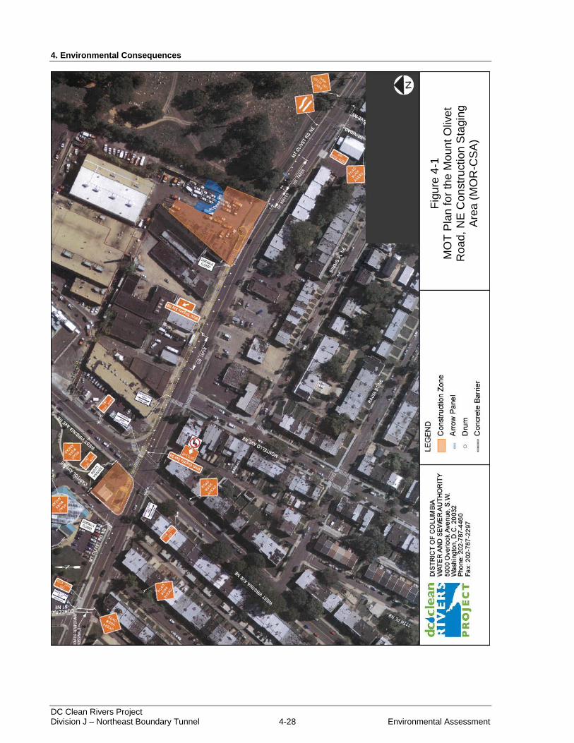
4. Environmental Consequences
DC Clean Rivers Project Division J – Northeast Boundary Tunnel 4-28 Environmental Assessment
Figure 4-1: MOT Plan for the Mount Olivet Road, NE Construction Staging Area (MOR-CSA)
Fig
ure
4-1
M
OT
Pla
n fo
r th
e M
oun
t O
live
t R
oa
d,
NE
Co
nstr
uctio
n S
tagin
g
Are
a (
MO
R-C
SA
)
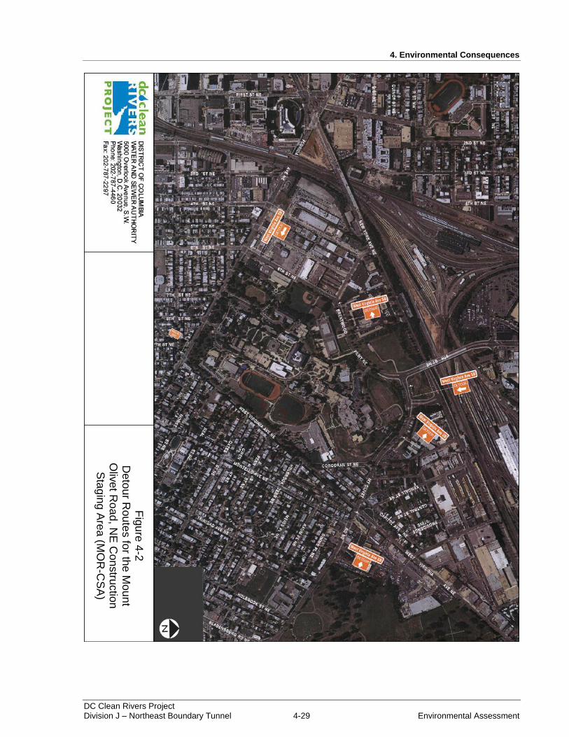
4. Environmental Consequences
DC Clean Rivers Project Division J – Northeast Boundary Tunnel 4-29 Environmental Assessment
Figure 4-2: Detour Routes for the Mount Olivet Road, NE Construction Staging Area (MOR-CSA)
Fig
ure
4-2
D
eto
ur R
ou
tes fo
r the
Mo
un
t O
live
t Roa
d, N
E C
on
stru
ctio
n
Sta
gin
g A
rea
(MO
R-C
SA
)
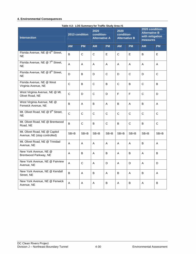
4. Environmental Consequences
DC Clean Rivers Project Division J – Northeast Boundary Tunnel 4-30 Environmental Assessment
Table 4-2: LOS Summary for Traffic Study Area #1
Intersection 2013 condition
2020
condition-
Alternative A
2020
condition-
Alternative B
2020 condition-
Alternative B
with mitigation
measures
AM PM AM PM AM PM AM PM
Florida Avenue, NE @ 6th Street,
NE B C C E C E B E
Florida Avenue, NE @ 7th Street,
NE A A A A A A A A
Florida Avenue, NE @ 8th Street,
NE D B D C D C D C
Florida Avenue, NE @ West
Virginia Avenue, NE C B C B C B C B
West Virginia Avenue, NE @ Mt.
Olivet Road, NE C D C D F F C D
West Virginia Avenue, NE @
Fenwick Avenue, NE B A B A B A B A
Mt. Olivet Road, NE @ 9th
Street,
NE C C C C C C C C
Mt. Olivet Road, NE @ Brentwood
Road, NE B C B C B C B C
Mt. Olivet Road, NE @ Capitol
Avenue, NE (stop controlled) SB=B SB=B SB=B SB=B SB=B SB=B SB=B SB=B
Mt. Olivet Road, NE @ Trinidad
Avenue, NE A A A A A A B A
New York Avenue, NE @
Brentwood Parkway, NE A B A B A B A B
New York Avenue, NE @ Fairview
Avenue, NE A C A D A D A D
New York Avenue, NE @ Kendall
Street, NE B A B A B A B A
New York Avenue, NE @ Fenwick
Avenue, NE A A A B A B A B

4. Environmental Consequences
DC Clean Rivers Project Division J – Northeast Boundary Tunnel 4-31 Environmental Assessment
4.13.2.2 Traffic Study Area #2
Under Alternative B, the proposed actions in Traffic Study Area #2 (see Figure 3-30), at the RIA-CSA,
would reduce Rhode Island Avenue travel lanes from six to four from west of Reed Street, NE to the
CSX/Washington Metropolitan Area Transit Authority railroad overpass. The two lanes and the roadway
median would be used for construction purposes. Figure 4-3 shows the proposed MOT plan for the RIA-
CSA.
Under Alternative B, two travel lanes on 4th Street, NE would be maintained during construction, but the
parking lanes and bicycle lanes adjacent to the 4S-CSA would be closed. Temporary widening would be
required along 4th Street, NE to maintain the two lanes. The lanes would be established to the east along
the current northbound parking lane and utility strip. Adams Street, NE would be closed at 4th Street, NE
and traffic would be detoured along 3rd
Street, NE and Bryant Street, NE. Figure 4-4 depicts the proposed
MOT plan for the 4S-CSA.
In general, LOS analysis of Traffic Study Area #2 indicated that NEBT construction would not reduce
LOS designations below the levels projected to occur by 2020. However, the proposed actions would
result in a sizeable reduction of service at the intersection of Rhode Island Avenue, NE at 4th Street, NE.
The growth and development of the Rhode Island Avenue corridor, in addition to the proposed
construction activities would result in a reduction from LOS C (AM designation) and LOS B (PM
designation) to LOS E (AM designation) and LOS D (PM designation) at the intersection. The reduction
would be due to the subtraction of southbound approach lanes on 4th Street, NE at Rhode Island Avenue,
NE.
In order to mitigate impacts at the intersection of Rhode Island Avenue, NE and 4th Street, NE, the
proposed actions would include additional traffic reducing measures. Bicycle and parking lanes on the
northbound approach to the intersection from 4th Street, NE would be temporarily removed to provide
more vehicle lane space. Also, signal timings at the intersection would be adjusted to reduce delays.
Through implementation of these measures, the LOS designation during evening peak hours would be
improved from D to C during construction. Increases in queuing distances along Rhode Island Avenue,
NE are expected, but the adjusted signal timings and offsets would assist in mitigating this issue.
Table 4-3 provides the results of the LOS analysis.

4. Environmental Consequences
DC Clean Rivers Project Division J – Northeast Boundary Tunnel 4-32 Environmental Assessment
Figure 4-3: MOT Plan for the Rhode Island Avenue, NE Construction Staging Area (RIA-CSA)
Fig
ure
4-3
M
OT
Pla
n fo
r th
e R
hod
e I
sla
nd
A
ve
nu
e,
NE
Co
nstr
uctio
n S
tagin
A
rea
(R
IA-C
SA
)
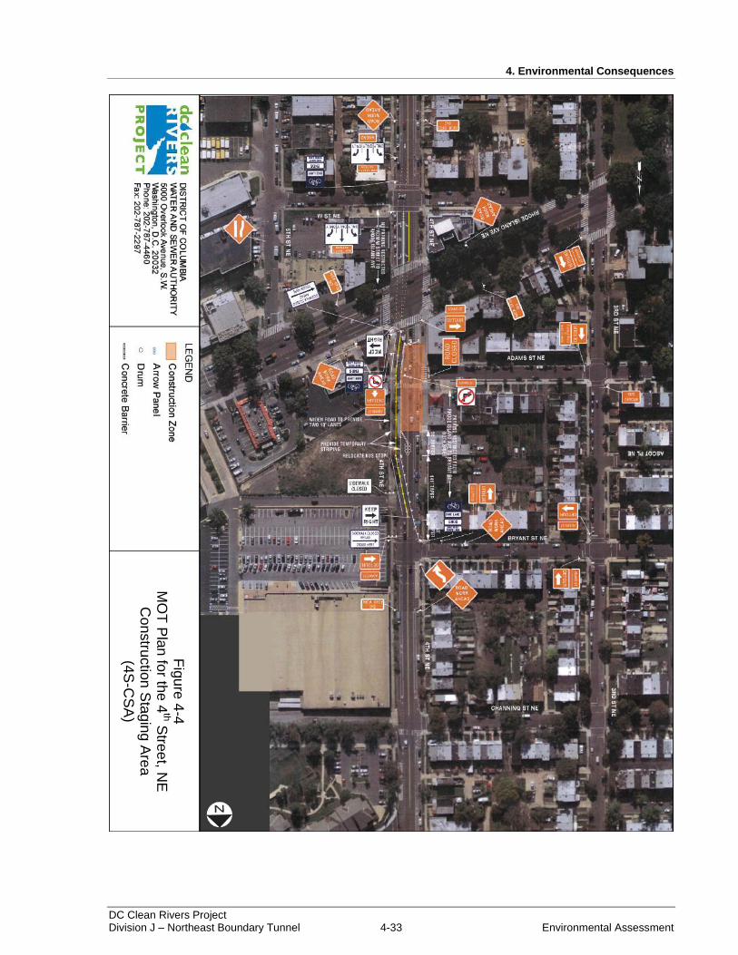
4. Environmental Consequences
DC Clean Rivers Project Division J – Northeast Boundary Tunnel 4-33 Environmental Assessment
Figure 4-4: MOT Plan for the 4
th Street, NE Construction Staging Area (4S-CSA)
Fig
ure
4-4
M
OT
Pla
n fo
r the
4th S
tree
t, NE
C
on
stru
ctio
n S
tagin
g A
rea
(4
S-C
SA
)
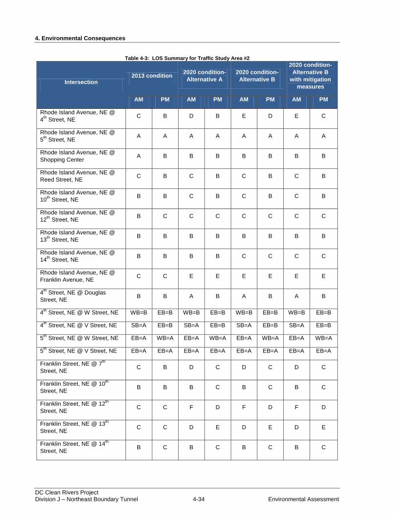
4. Environmental Consequences
DC Clean Rivers Project Division J – Northeast Boundary Tunnel 4-34 Environmental Assessment
Table 4-3: LOS Summary for Traffic Study Area #2
Intersection 2013 condition
2020 condition-
Alternative A
2020 condition-
Alternative B
2020 condition-
Alternative B
with mitigation
measures
AM PM AM PM AM PM AM PM
Rhode Island Avenue, NE @
4th
Street, NE C B D B E D E C
Rhode Island Avenue, NE @
5th
Street, NE A A A A A A A A
Rhode Island Avenue, NE @
Shopping Center A B B B B B B B
Rhode Island Avenue, NE @
Reed Street, NE C B C B C B C B
Rhode Island Avenue, NE @
10th
Street, NE B B C B C B C B
Rhode Island Avenue, NE @
12th
Street, NE B C C C C C C C
Rhode Island Avenue, NE @
13th
Street, NE B B B B B B B B
Rhode Island Avenue, NE @
14th
Street, NE B B B B C C C C
Rhode Island Avenue, NE @
Franklin Avenue, NE C C E E E E E E
4th
Street, NE @ Douglas
Street, NE B B A B A B A B
4th
Street, NE @ W Street, NE WB=B EB=B WB=B EB=B WB=B EB=B WB=B EB=B
4th
Street, NE @ V Street, NE SB=A EB=B SB=A EB=B SB=A EB=B SB=A EB=B
5th
Street, NE @ W Street, NE EB=A WB=A EB=A WB=A EB=A WB=A EB=A WB=A
5th
Street, NE @ V Street, NE EB=A EB=A EB=A EB=A EB=A EB=A EB=A EB=A
Franklin Street, NE @ 7th
Street, NE C B D C D C D C
Franklin Street, NE @ 10th
Street, NE B B B C B C B C
Franklin Street, NE @ 12th
Street, NE C C F D F D F D
Franklin Street, NE @ 13th
Street, NE C C D E D E D E
Franklin Street, NE @ 14th
Street, NE B C B C B C B C
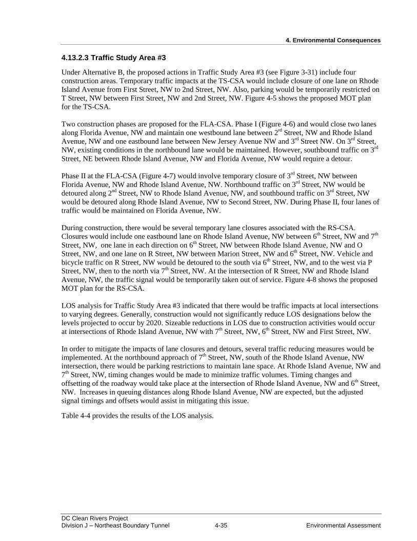
4. Environmental Consequences
DC Clean Rivers Project Division J – Northeast Boundary Tunnel 4-35 Environmental Assessment
4.13.2.3 Traffic Study Area #3
Under Alternative B, the proposed actions in Traffic Study Area #3 (see Figure 3-31) include four
construction areas. Temporary traffic impacts at the TS-CSA would include closure of one lane on Rhode
Island Avenue from First Street, NW to 2nd Street, NW. Also, parking would be temporarily restricted on
T Street, NW between First Street, NW and 2nd Street, NW. Figure 4-5 shows the proposed MOT plan
for the TS-CSA.
Two construction phases are proposed for the FLA-CSA. Phase I (Figure 4-6) and would close two lanes
along Florida Avenue, NW and maintain one westbound lane between 2rd
Street, NW and Rhode Island
Avenue, NW and one eastbound lane between New Jersey Avenue NW and 3rd
Street NW. On 3rd
Street,
NW, existing conditions in the northbound lane would be maintained. However, southbound traffic on 3rd
Street, NE between Rhode Island Avenue, NW and Florida Avenue, NW would require a detour.
Phase II at the FLA-CSA (Figure 4-7) would involve temporary closure of 3rd
Street, NW between
Florida Avenue, NW and Rhode Island Avenue, NW. Northbound traffic on 3rd
Street, NW would be
detoured along 2nd
Street, NW to Rhode Island Avenue, NW, and southbound traffic on 3rd
Street, NW
would be detoured along Rhode Island Avenue, NW to Second Street, NW. During Phase II, four lanes of
traffic would be maintained on Florida Avenue, NW.
During construction, there would be several temporary lane closures associated with the RS-CSA.
Closures would include one eastbound lane on Rhode Island Avenue, NW between 6th Street, NW and 7
th
Street, NW, one lane in each direction on 6th Street, NW between Rhode Island Avenue, NW and O
Street, NW, and one lane on R Street, NW between Marion Street, NW and 6th Street, NW. Vehicle and
bicycle traffic on R Street, NW would be detoured to the south via 6th Street, NW, and to the west via P
Street, NW, then to the north via 7th Street, NW. At the intersection of R Street, NW and Rhode Island
Avenue, NW, the traffic signal would be temporarily taken out of service. Figure 4-8 shows the proposed
MOT plan for the RS-CSA.
LOS analysis for Traffic Study Area #3 indicated that there would be traffic impacts at local intersections
to varying degrees. Generally, construction would not significantly reduce LOS designations below the
levels projected to occur by 2020. Sizeable reductions in LOS due to construction activities would occur
at intersections of Rhode Island Avenue, NW with 7th Street, NW, 6
th Street, NW and First Street, NW.
In order to mitigate the impacts of lane closures and detours, several traffic reducing measures would be
implemented. At the northbound approach of 7th Street, NW, south of the Rhode Island Avenue, NW
intersection, there would be parking restrictions to maintain lane space. At Rhode Island Avenue, NW and
7th Street, NW, timing changes would be made to minimize traffic volumes. Timing changes and
offsetting of the roadway would take place at the intersection of Rhode Island Avenue, NW and 6th Street,
NW. Increases in queuing distances along Rhode Island Avenue, NW are expected, but the adjusted
signal timings and offsets would assist in mitigating this issue.
Table 4-4 provides the results of the LOS analysis.
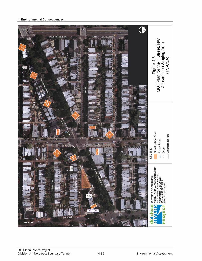
4. Environmental Consequences
DC Clean Rivers Project Division J – Northeast Boundary Tunnel 4-36 Environmental Assessment
Figure 4-5: MOT Plan for the T Street, NW Construction Staging Area (TS-CSA)
Fig
ure
4-5
M
OT
Pla
n fo
r th
e T
Str
ee
t, N
W
Con
str
uction
Sta
gin
g A
rea
(T
S-C
SA
)
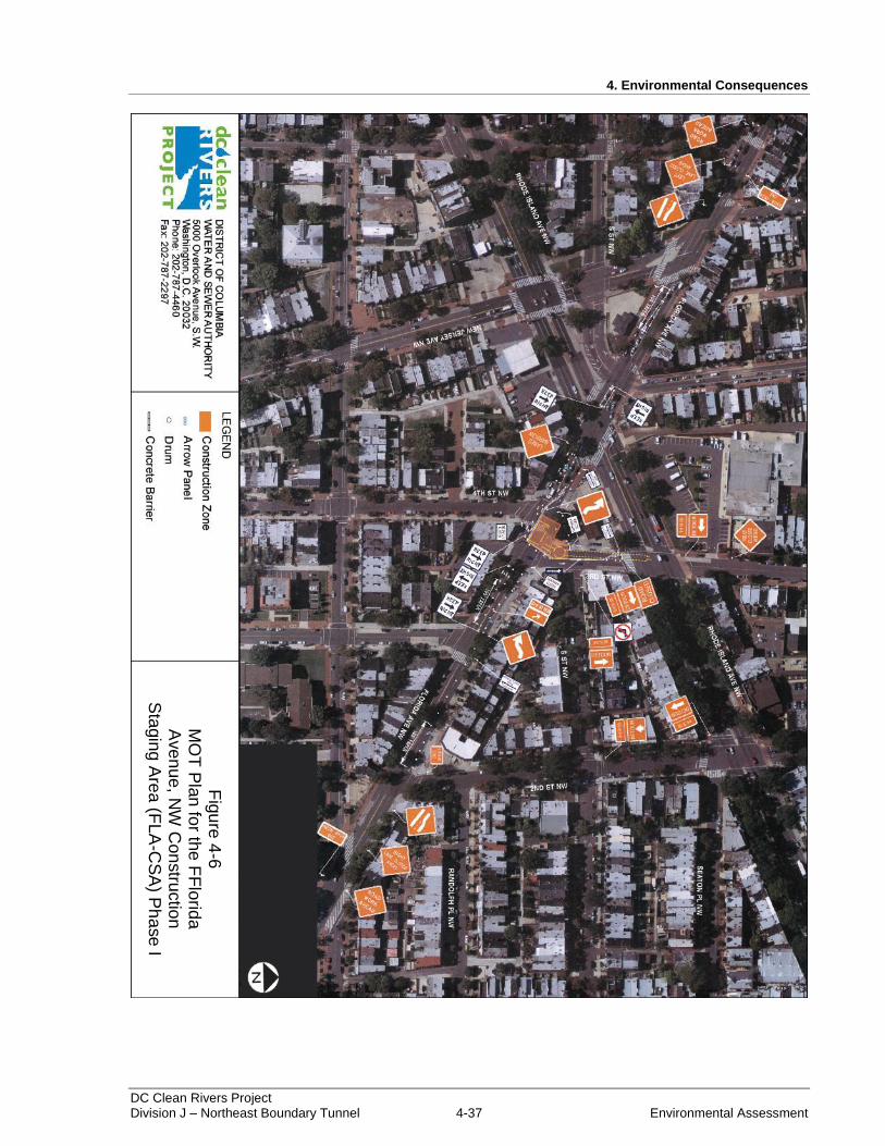
4. Environmental Consequences
DC Clean Rivers Project Division J – Northeast Boundary Tunnel 4-37 Environmental Assessment
Figure 4-6: MOT Plan for the Florida Avenue, NW Construction Staging Area (FLA-CSA) Phase I
Fig
ure
4-6
M
OT
Pla
n fo
r the
FF
lorid
a
Ave
nu
e, N
W C
on
stru
ctio
n
Sta
gin
g A
rea
(FLA
-CS
A) P
ha
se
I

4. Environmental Consequences
DC Clean Rivers Project Division J – Northeast Boundary Tunnel 4-38 Environmental Assessment
Figure 4-7: MOT Plan for the Florida Avenue, NW Construction Staging Area (FLA-CSA) Phase II
Fig
ure
4-7
M
OT
Pla
n fo
r th
e F
lorida
A
ve
nu
e,
NW
Con
str
uction
S
tagin
g A
rea
(F
LA
-CS
A)
Ph
ase I
I
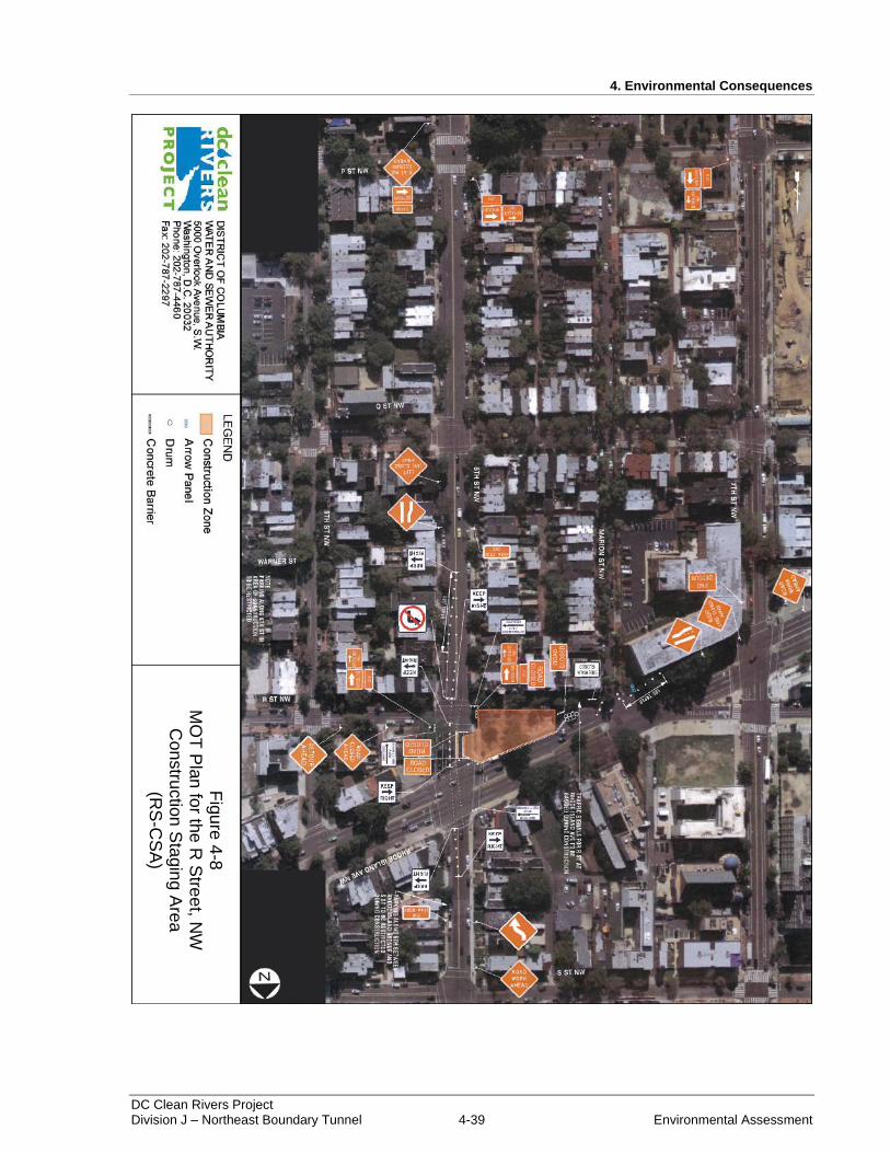
4. Environmental Consequences
DC Clean Rivers Project Division J – Northeast Boundary Tunnel 4-39 Environmental Assessment
Figure 4-8: MOT Plan for the R Street, NW Construction Staging Area (RS-CSA)
Fig
ure
4-8
M
OT
Pla
n fo
r the
R S
tree
t, NW
C
on
stru
ctio
n S
tagin
g A
rea
(R
S-C
SA
)
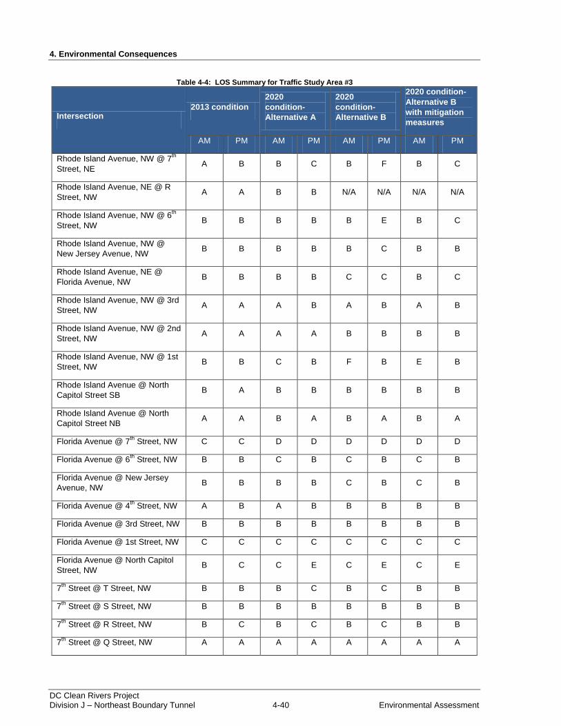
4. Environmental Consequences
DC Clean Rivers Project Division J – Northeast Boundary Tunnel 4-40 Environmental Assessment
Table 4-4: LOS Summary for Traffic Study Area #3
Intersection 2013 condition
2020
condition-
Alternative A
2020
condition-
Alternative B
2020 condition-
Alternative B
with mitigation
measures
AM PM AM PM AM PM AM PM
Rhode Island Avenue, NW @ 7th
Street, NE A B B C B F B C
Rhode Island Avenue, NE @ R
Street, NW A A B B N/A N/A N/A N/A
Rhode Island Avenue, NW @ 6th
Street, NW B B B B B E B C
Rhode Island Avenue, NW @
New Jersey Avenue, NW B B B B B C B B
Rhode Island Avenue, NE @
Florida Avenue, NW B B B B C C B C
Rhode Island Avenue, NW @ 3rd
Street, NW A A A B A B A B
Rhode Island Avenue, NW @ 2nd
Street, NW A A A A B B B B
Rhode Island Avenue, NW @ 1st
Street, NW B B C B F B E B
Rhode Island Avenue @ North
Capitol Street SB B A B B B B B B
Rhode Island Avenue @ North
Capitol Street NB A A B A B A B A
Florida Avenue @ 7th
Street, NW C C D D D D D D
Florida Avenue @ 6th
Street, NW B B C B C B C B
Florida Avenue @ New Jersey
Avenue, NW B B B B C B C B
Florida Avenue @ 4th
Street, NW A B A B B B B B
Florida Avenue @ 3rd Street, NW B B B B B B B B
Florida Avenue @ 1st Street, NW C C C C C C C C
Florida Avenue @ North Capitol
Street, NW B C C E C E C E
7th
Street @ T Street, NW B B B C B C B B
7th
Street @ S Street, NW B B B B B B B B
7th
Street @ R Street, NW B C B C B C B B
7th
Street @ Q Street, NW A A A A A A A A
4. Environmental Consequences
DC Clean Rivers Project Division J – Northeast Boundary Tunnel 4-41 Environmental Assessment
6th
Street @ S Street, NW C C C C C C C C
6th
Street @ R Street, NW B A B A A A A A
6th
Street @ Q Street, NW A B A B A B A B
New Jersey Avenue @ S Street,
NW A B A B A B A A
New Jersey Avenue @ R Street,
NW B A B B B B B B
New Jersey Avenue @ Q Street,
NW A A A A A A A A
1st Street @ Q Street, NW C B C B C B C B
North Capitol Street @ Randolph
Street C B F D F D F D
North Capitol Street @ R Street A A A E A E A E
Note: Both phases of construction at the Florida Avenue, NW CSA were analyzed. For the purposes of this document only Phase I impacts compared to the 2020 background LOS are provided. Phase II was shown to have similar impacts to the LOS ratings and similar improvements would be made to mitigate delays.
4.13.2.4 Pedestrian and Bicycle Traffic
Under Alternative B, local roads and sidewalks would be temporarily converted to active construction
sites. DC Water would coordinate with the District Department of Transportation to establish safe detours
and road crossings for pedestrians and bicyclists where sidewalks are to be closed. Although segments of
sidewalks would be temporarily closed in order to facilitate construction activities, pedestrian access to
homes and businesses would be maintained for the duration of construction. Safe separation between
work areas and pedestrian access routes would also be maintained. The separation would depend on the
dimensions, configuration and activities taking place within work areas. For example, deep trenches or
pits would require concrete barriers with chain link fencing while minor surface disturbances would call
for orange construction fencing. For bicyclists, directional signage would be placed in a manner similar to
automobile signage in advance of detours and road closures. In addition, temporary access routes would
be developed in consideration of ADA requirements.
4.13.2.5 Impacts of Alternative B – Northeast Boundary Tunnel (NEBT)
Based on the preceding information, Alternative B would result in short-term moderate adverse impacts
on traffic and transportation. Construction activities at the CSAs would require temporary lane restrictions
and closures, and would temporarily reduce the number of street parking spaces available to residents.
Consequently, the level of service at project area intersections would be reduced. Also, based on the
proposed hauling activities and workers at the CSAs, there would be a noticeable increase in the number
of vehicles on area roadways. Mitigation measures would be applied to reduce impacts where possible;
however, the adverse effects on project area traffic associated with construction would be readily apparent
and appreciable.
For the duration of construction, Alternative B would require coordination between DC Water and the
District Department of Transportation to establish detours, lane closures, parking closures, and traffic
signal modifications. Prior to street closures and lane restrictions, DC Water would provide Traffic
Control Plans to the District Department of Transportation and would receive required approvals. DC
4. Environmental Consequences
DC Clean Rivers Project Division J – Northeast Boundary Tunnel 4-42 Environmental Assessment
Water would also coordinate with the Washington Metropolitan Area Transit Authority for any
disruptions to bus operations.
Once constructed, the NEBT would provide capacity for combined sewer overflows, which would
mitigate combined sewer flooding and basement backups. The flooding of roadways due to surcharged
sewers would be significantly reduced, which would enhance the service provided by the roadway
network. Following construction, lane closures and restrictions associated with CSAs would be removed
and the areas would generally return to pre-construction conditions. As a result, Alternative B would
provide long-term minor benefits to the transportation and traffic network in the Northeast Boundary
sewershed.
4.13.2.6 Cumulative Impacts
Cumulative impacts projects in the vicinity of the project area include improvements to the local
transportation network. Projects such as the rehabilitation of the East Capitol Street Bridge and the
reconstruction of Florida Avenue, NW would provide long-term benefits to the transportation network of
the area. However, during construction of the improvements, work activities would add to the congestion
of local roadways and would require temporary road restrictions and detours. In addition, a host of land
development projects are proposed in the vicinity of the project area. Land development to establish new
residential and commercial spaces would also add to the congestion of local roads, and could call for
temporary lane closures. Similarly, Alternative B would have short term moderate adverse impacts on
traffic for the duration of NEBT construction. When combined with the effects of projects nearby, there
would be an incremental effect on local roadways. Due to the amount of construction vehicles and
equipment in the area, Alternative B and nearby projects would result in short-term moderate adverse
cumulative impacts.
4.13.2.7 Mitigation Measures
Prior to construction, mitigation measures would include Traffic Control Plans which would define
detours and changes in traffic patterns. Additional mitigation measures are outlined based on the study
areas established by LOS analysis for the project area.
Traffic Study Area #1
Restrict northbound Mt. Olivet Road, NE traffic from turning left onto West Virginia Avenue,
NE.
Adjust signal timings at the intersection to reduce delays.
Traffic Study Area #2
Modify the northbound approach of 4th Street, NE.
Eliminate the bike and parking lanes and restripe the roadway between 4th Street, NE and Rhode
Island Avenue, NE.
Adjust signal timings at the intersection to reduce delays.
Traffic Study Area #3
Parking restrictions along the northbound approach of 7th Street, NW south of the Rhode Island
Avenue, NW intersection.
Phasing and timing changes at the intersection of Rhode Island Avenue, NW and 7th Street, NW.
4. Environmental Consequences
DC Clean Rivers Project Division J – Northeast Boundary Tunnel 4-43 Environmental Assessment
Timing and offset modifications at the intersection of Rhode Island Avenue, NW and 6th Street,
NW.
Adjust signal timings at the intersection to reduce delays.
4.14 Socioeconomics
4.14.1 Alternative A – No Action Alternative
Under Alternative A, combined sewer flooding and basement backups would continue to occur. In
addition to the nuisance caused by flooding, residents would continue to suffer costs of cleanup and
damages to property. The threat of future flooding would likely continue to have unfavorable effects on
property values. Additionally, the beneficial impacts to economy, income, taxes and revenue related to the
construction of the NEBT would not occur under Alternative A. Based on these factors, Alternative A
would result in long-term moderate adverse impacts to the socioeconomic environment.
4.14.1.1 Cumulative Impacts
Although redevelopment and proposed mixed-use developments would support healthy socioeconomic
conditions, the projects identified in Table 4-1 would also increase the impervious area and generate
additional sanitary flows within the Northeast Boundary drainage area. Proposed projects in the
cumulative impact study area would connect with the existing combined sewer system to convey
wastewater and stormwater offsite. Consequently, combined sewer flooding in the Northeast Boundary
sewershed would be exacerbated, due to the additional flows received by the system. As a result of the
potential for more frequent and more severe combined sewer flooding, there would be long-term
moderate adverse cumulative impacts under Alternative A.
4.14.2 Alternative B – Northeast Boundary Tunnel (NEBT)
Under Alternative B, regional economic activity would increase as local construction contractors and
construction firms are hired for the over $500 million project. The purchase of construction materials and
equipment, as well as spending by the construction workers would add income to the economy.
Therefore, the proposed action would have a short-term beneficial impact on the regional economy. In
addition, short-term beneficial impacts on employment could occur from the addition of jobs related to
construction of the NEBT.
Increased sales transactions for the purchase of materials and supplies would generate additional tax
revenues for the local government. Increases to the construction labor force would increase revenue
generated through income taxes, resulting in short-term beneficial impacts.
Road closures could temporarily impact local businesses, churches, and other community facilities with
the project area. Based on the disruptive nature of construction activities, there would be a short-term
minor adverse impact to local businesses and community facilities due to temporary traffic impacts.
Overall, implementation of Alternative B would enhance the communities within the project area through
the provision of adequate sewer infrastructure. Therefore, there would be long-term socioeconomic
benefits under Alternative B.
4.14.2.1 Cumulative Impacts
As described under Alternative A, past, present, and reasonably foreseeable future projects would result
in overall socioeconomic benefits. Although there would be short-term disruptions associated with its
4. Environmental Consequences
DC Clean Rivers Project Division J – Northeast Boundary Tunnel 4-44 Environmental Assessment
construction, the overall improvement provided by the NEBT would provide socioeconomic benefits to
the community. Therefore, the combined effect of cumulative impacts projects and the NEBT would
result in benefits to the socioeconomic environment.
4.14.2.2 Mitigation Measures
The following mitigation measures would be implemented to minimize impacts to socioeconomics:
Access to homes and businesses would be maintained.
Signage stating businesses are open would be posted along pedestrian access routes that are adjacent
to the CSAs.
4.15 Community Facilities and Services
4.15.1 Alternative A – No Action Alternative
Under Alternative A, combined sewer flooding and basement backups would continue to occur. In
addition to the nuisance caused by flooding, community facilities and services would suffer costs of
cleanup and damages to property. Continued flooding could also have an impact on response times of law
enforcement, emergency response, and fire protection services. Based on these factors, Alternative A
would result in long-term moderate adverse impacts to community facilities and services.
4.15.1.1 Cumulative Impacts
The projects identified in Table 4-1 would increase the impervious area and generate additional sanitary
flows within the Northeast Boundary drainage area. Proposed projects in the cumulative impact study
area would connect with the existing combined sewer system to convey wastewater and stormwater
offsite. Consequently, combined sewer flooding in the Northeast Boundary sewershed would be
exacerbated, due to the additional flows received by the system. Continued flooding would cause further
damage to community facilities and services housed within the study area as well as potentially increase
response times of law enforcement, emergency response, fire protection services. As a result of the
potential for more frequent and more severe combined sewer flooding and associated impacts to
community facilities and services, there would be long-term moderate adverse cumulative impacts under
Alternative A.
4.15.2 Alternative B – Northeast Boundary Tunnel (NEBT)
Emergencies (police, local medical, fire protection, and rescue services) during construction of the
proposed project would not be expected to increase the demand for emergency services beyond current
available capacity. The project area is currently served with adequate emergency staff. As a result, there
would be a short-term negligible to minor impact to emergency services.
Temporary detours and lane restrictions could temporarily impact schools, local businesses, churches, and
other community facilities within the project area. Based on the nature of construction activities, there
would be short-term minor adverse impacts to local businesses and community facilities due to temporary
traffic impacts.
For residential trash collection, snow removal, and recycling, ongoing coordination with the Department
of Public Works would take place as the project progresses to meet the needs of residents. Similarly, DC
Water would coordinate with the United States Postal Service to maintain mail delivery services. Mail
delivery is expected to continue without interruption for residents and businesses in the vicinity of CSAs.
4. Environmental Consequences
DC Clean Rivers Project Division J – Northeast Boundary Tunnel 4-45 Environmental Assessment
Overall, implementation of Alternative B would reduce flooding and enhance community facilities and
services within the project area through the provision of adequate sewer infrastructure. Response times of
law enforcement, emergency response, and fire protection services during heavy rain events could also be
reduced. Therefore, there would be long-term benefits to community facilities and services under
Alternative B.
4.15.2.1 Cumulative Impacts
Overall, the NEBT would provide substantial community benefits through the reduction of combined
sewer flooding. Therefore, the project would not contribute to adverse cumulative impacts to community
facilities and services within the project area.
4.15.2.2 Mitigation Measures
The following mitigation measures would be implemented to minimize impacts to community facilities
and services:
Implement approved traffic control plans and review on a regular basis with DC Fire and EMS.
Access to District services (i.e. refuse, recycling, postal services, snow removal, etc.) would be
maintained throughout construction.
Access to businesses and community facilities would be maintained.
Signage stating businesses are open would be posted along pedestrian access routes adjacent to the
CSAs.
4.16 Adverse Environmental Effects that Cannot be Avoided
Unavoidable adverse impacts of the proposed action would include, short-term temporary impacts, such
as noise, air emissions, and occasional traffic congestion associated with construction activities.
Unavoidable long-term adverse effects would include impacts to archaeological resources at the WS-CSA
and potential impacts to archaeological resources at the RS-CSA. In all cases, mitigation measures would
be developed to minimize these impacts, and impacts would be addressed in compliance with local and
Federal regulations.
4.17 Irreversible or Irretrievable Commitment of Resources
The proposed action would require the commitment of land for construction of Alternative B. Since the
majority of construction would be below ground, the total commitment would primarily include the
removal of soils. The loss of these resources would be permanent.
A commitment of fuel and energy would be required to construct the NEBT project. Other resource
commitments during the construction period would include construction materials and labor. There would
be an additional long-term commitment of labor for the maintenance of infrastructure. All of these
resources relating to the construction and maintenance of the NEBT infrastructure should be considered
irretrievably committed.
4. Environmental Consequences
DC Clean Rivers Project Division J – Northeast Boundary Tunnel 4-46 Environmental Assessment
THIS PAGE INTENTIONALLY LEFT BLANK.
.