2nd day: The Buntsandstein of Eastern...
13
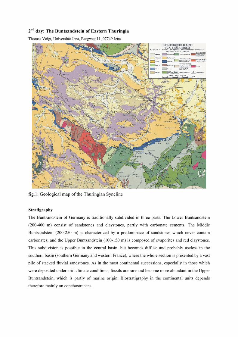
2 nd day: The Buntsandstein of Eastern Thuringia Thomas Voigt, Universität Jena, Burgweg 11, 07749 Jena fig.1: Geological map of the Thuringian Syncline Stratigraphy The Buntsandstein of Germany is traditionally subdivided in three parts: The Lower Buntsandstein (200-400 m) consist of sandstones and claystones, partly with carbonate cements. The Middle Buntsandstein (200-250 m) is characterized by a predominace of sandstones which never contain carbonates; and the Upper Buntsandstein (100-150 m) is composed of evaporites and red claystones. This subdivision is possible in the central basin, but becomes diffuse and probably useless in the southern basin (southern Germany and western France), where the whole section is presented by a vast pile of stacked fluvial sandstones. As in the most continental successions, especially in those which were deposited under arid climate conditions, fossils are rare and become more abundant in the Upper Buntsandstein, which is partly of marine origin. Biostratigraphy in the continental units depends therefore mainly on conchostracans.
Transcript of 2nd day: The Buntsandstein of Eastern...
2nd day: The Buntsandstein of Eastern Thuringia
Thomas Voigt, Universität Jena, Burgweg 11, 07749 Jena
fig.1: Geological map of the Thuringian Syncline
Stratigraphy
The Buntsandstein of Germany is traditionally subdivided in three parts: The Lower Buntsandstein
(200-400 m) consist of sandstones and claystones, partly with carbonate cements. The Middle
Buntsandstein (200-250 m) is characterized by a predominace of sandstones which never contain
carbonates; and the Upper Buntsandstein (100-150 m) is composed of evaporites and red claystones.
This subdivision is possible in the central basin, but becomes diffuse and probably useless in the
southern basin (southern Germany and western France), where the whole section is presented by a vast
pile of stacked fluvial sandstones. As in the most continental successions, especially in those which
were deposited under arid climate conditions, fossils are rare and become more abundant in the Upper
Buntsandstein, which is partly of marine origin. Biostratigraphy in the continental units depends
therefore mainly on conchostracans.
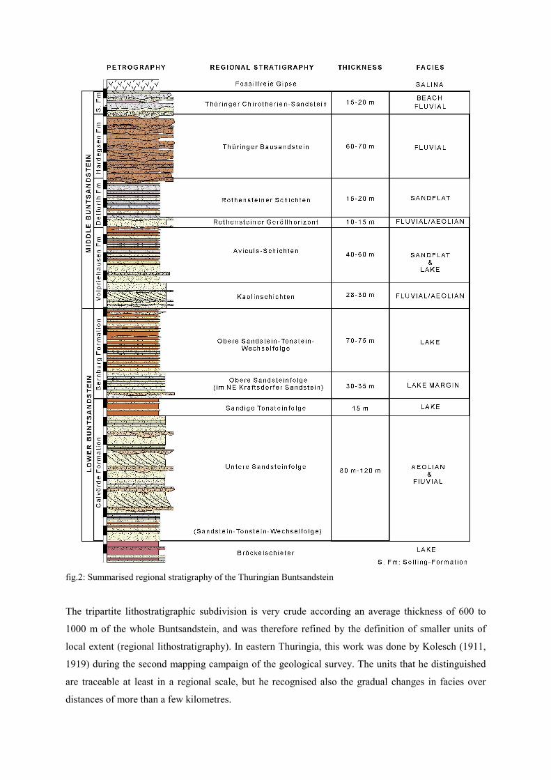
fig.2: Summarised regional stratigraphy of the Thuringian Buntsandstein
The tripartite lithostratigraphic subdivision is very crude according an average thickness of 600 to
1000 m of the whole Buntsandstein, and was therefore refined by the definition of smaller units of
local extent (regional lithostratigraphy). In eastern Thuringia, this work was done by Kolesch (1911,
1919) during the second mapping campaign of the geological survey. The units that he distinguished
are traceable at least in a regional scale, but he recognised also the gradual changes in facies over
distances of more than a few kilometres.
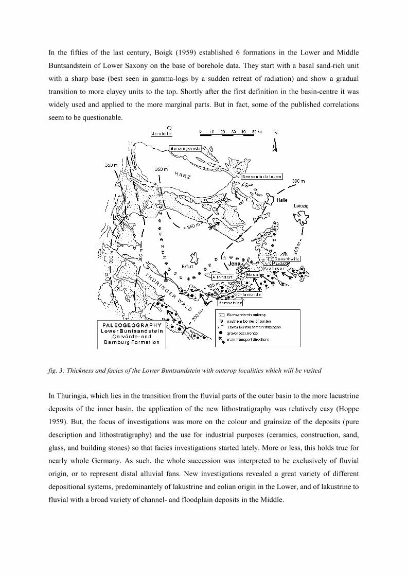
In the fifties of the last century, Boigk (1959) established 6 formations in the Lower and Middle
Buntsandstein of Lower Saxony on the base of borehole data. They start with a basal sand-rich unit
with a sharp base (best seen in gamma-logs by a sudden retreat of radiation) and show a gradual
transition to more clayey units to the top. Shortly after the first definition in the basin-centre it was
widely used and applied to the more marginal parts. But in fact, some of the published correlations
seem to be questionable.
fig. 3: Thickness and facies of the Lower Buntsandstein with outcrop localities which will be visited
In Thuringia, which lies in the transition from the fluvial parts of the outer basin to the more lacustrine
deposits of the inner basin, the application of the new lithostratigraphy was relatively easy (Hoppe
1959). But, the focus of investigations was more on the colour and grainsize of the deposits (pure
description and lithostratigraphy) and the use for industrial purposes (ceramics, construction, sand,
glass, and building stones) so that facies investigations started lately. More or less, this holds true for
nearly whole Germany. As such, the whole succession was interpreted to be exclusively of fluvial
origin, or to represent distal alluvial fans. New investigations revealed a great variety of different
depositional systems, predominantely of lakustrine and eolian origin in the Lower, and of lakustrine to
fluvial with a broad variety of channel- and floodplain deposits in the Middle.
During this day, we want to present an overview over different depositional systems of the
Buntsandstein. We start in the Saale-valley about 40 km south of Jena and start with the oldest
deposits. This is possible, because the Saale-river cuts into a large syncline between the basement
uplifts of the Thuringian forest and the Harz mountains (Cretaceous inversion structures, very similar
to Krkonose and Jizerske hory).
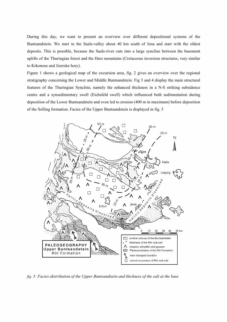
Figure 1 shows a geological map of the excursion area, fig. 2 gives an overview over the regional
stratigraphy concerning the Lower and Middle Buntsandstein. Fig 3 and 4 display the main structural
features of the Thuringian Syncline, namely the enhanced thickness in a N-S striking subsidence
centre and a synsedimentary swell (Eichsfeld swell) which influenced both sedimentation during
deposition of the Lower Buntsandstein and even led to erosion (400 m in maximum) before deposition
of the Solling formation. Facies of the Upper Buntsandstein is displayed in fig. 5
fig. 5: Facies-distribution of the Upper Buntsandstein and thickness of the salt at the base
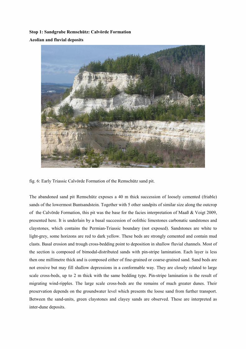
Stop 1: Sandgrube Remschütz: Calvörde Formation
Aeolian and fluvial deposits
fig. 6: Early Triassic Calvörde Formation of the Remschütz sand pit.
The abandoned sand pit Remschütz exposes a 40 m thick succession of loosely cemented (friable)
sands of the lowermost Buntsandstein. Together with 5 other sandpits of similar size along the outcrop
of the Calvörde Formation, this pit was the base for the facies interpretation of Maaß & Voigt 2009,
presented here. It is underlain by a basal succession of oolithic limestones carbonatic sandstones and
claystones, which contains the Permian-Triassic boundary (not exposed). Sandstones are white to
light-grey, some horizons are red to dark yellow. These beds are strongly cemented and contain mud
clasts. Basal erosion and trough cross-bedding point to deposition in shallow fluvial channels. Most of
the section is composed of bimodal-distributed sands with pin-stripe lamination. Each layer is less
then one millimetre thick and is composed either of fine-grained or coarse-grained sand. Sand beds are
not erosive but may fill shallow depressions in a conformable way. They are closely related to large
scale cross-beds, up to 2 m thick with the same bedding type. Pin-stripe lamination is the result of
migrating wind-ripples. The large scale cross-beds are the remains of much greater dunes. Their
preservation depends on the groundwater level which presents the loose sand from further transport.
Between the sand-units, green claystones and clayey sands are observed. These are interpreted as
inter-dune deposits.
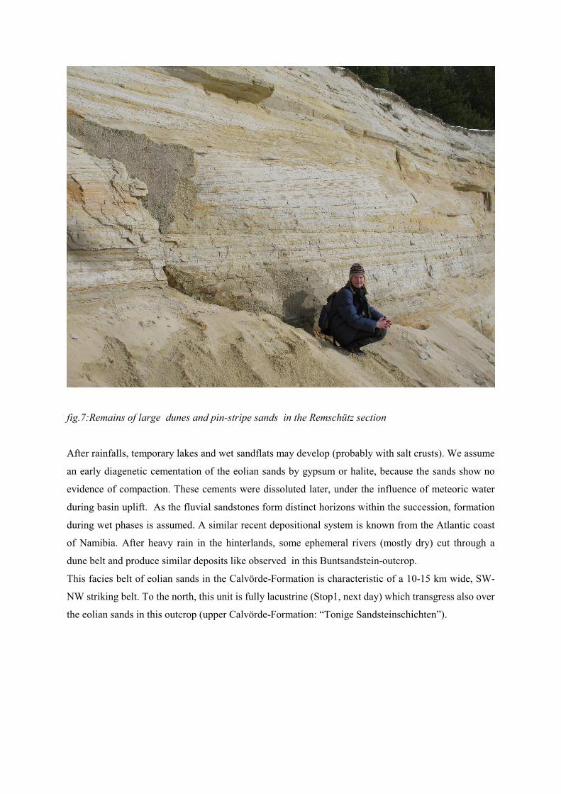
fig.7:Remains of large dunes and pin-stripe sands in the Remschütz section
After rainfalls, temporary lakes and wet sandflats may develop (probably with salt crusts). We assume
an early diagenetic cementation of the eolian sands by gypsum or halite, because the sands show no
evidence of compaction. These cements were dissoluted later, under the influence of meteoric water
during basin uplift. As the fluvial sandstones form distinct horizons within the succession, formation
during wet phases is assumed. A similar recent depositional system is known from the Atlantic coast
of Namibia. After heavy rain in the hinterlands, some ephemeral rivers (mostly dry) cut through a
dune belt and produce similar deposits like observed in this Buntsandstein-outcrop.
This facies belt of eolian sands in the Calvörde-Formation is characteristic of a 10-15 km wide, SW-
NW striking belt. To the north, this unit is fully lacustrine (Stop1, next day) which transgress also over
the eolian sands in this outcrop (upper Calvörde-Formation: “Tonige Sandsteinschichten”).
Stop 2: Orlamünde, Bernburg formation
Wet and dry sandflat, lake deposits, (terminal fan?)
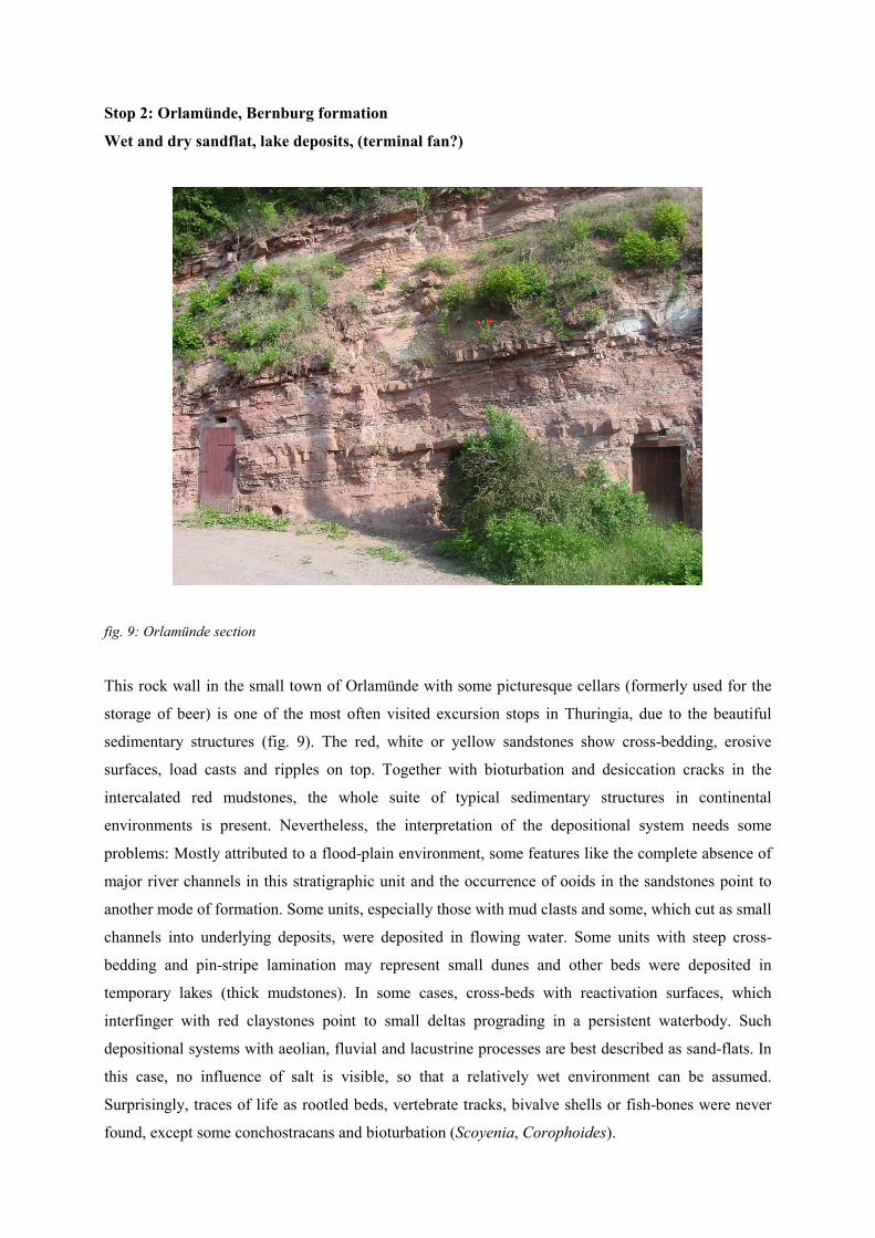
fig. 9: Orlamünde section
This rock wall in the small town of Orlamünde with some picturesque cellars (formerly used for the
storage of beer) is one of the most often visited excursion stops in Thuringia, due to the beautiful
sedimentary structures (fig. 9). The red, white or yellow sandstones show cross-bedding, erosive
surfaces, load casts and ripples on top. Together with bioturbation and desiccation cracks in the
intercalated red mudstones, the whole suite of typical sedimentary structures in continental
environments is present. Nevertheless, the interpretation of the depositional system needs some
problems: Mostly attributed to a flood-plain environment, some features like the complete absence of
major river channels in this stratigraphic unit and the occurrence of ooids in the sandstones point to
another mode of formation. Some units, especially those with mud clasts and some, which cut as small
channels into underlying deposits, were deposited in flowing water. Some units with steep cross-
bedding and pin-stripe lamination may represent small dunes and other beds were deposited in
temporary lakes (thick mudstones). In some cases, cross-beds with reactivation surfaces, which
interfinger with red claystones point to small deltas prograding in a persistent waterbody. Such
depositional systems with aeolian, fluvial and lacustrine processes are best described as sand-flats. In
this case, no influence of salt is visible, so that a relatively wet environment can be assumed.
Surprisingly, traces of life as rootled beds, vertebrate tracks, bivalve shells or fish-bones were never
found, except some conchostracans and bioturbation (Scoyenia, Corophoides).
Although the existence of terminal fans in the fossil record was completely neglected by some authors,
the interpretation of a river delta which ended in a large plain is the preferred interpretation of this
environment. A good modern example is the Seravshan river in Usbekistan, which is sourced b the
glaciers of the Western Tien Shan and enters the Kyzylkum desert. The Seravshan does not reach the
Syrdarya, because all water is lost to the porous deposits in the subground. The delta (terminal fan)
consists of hundreds of small channels and is about 30 km wide. In spring, during highest discharge,
major areas are covered by shallow water for a short time (temporary lakes with mud deposition). In
summer, the area runs dry and is affected by the wind which transports sand and forms small dunes
(barchans). A similar depositional system would explain the rapid changes of lakustrine, fluvial and
aeolian deposits which occurs in the this outcrop.
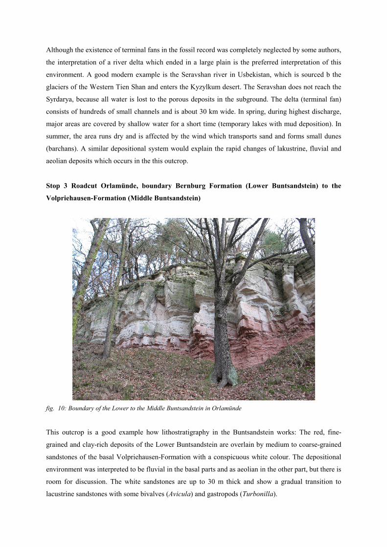
Stop 3 Roadcut Orlamünde, boundary Bernburg Formation (Lower Buntsandstein) to the
Volpriehausen-Formation (Middle Buntsandstein)
fig. 10: Boundary of the Lower to the Middle Buntsandstein in Orlamünde
This outcrop is a good example how lithostratigraphy in the Buntsandstein works: The red, fine-
grained and clay-rich deposits of the Lower Buntsandstein are overlain by medium to coarse-grained
sandstones of the basal Volpriehausen-Formation with a conspicuous white colour. The depositional
environment was interpreted to be fluvial in the basal parts and as aeolian in the other part, but there is
room for discussion. The white sandstones are up to 30 m thick and show a gradual transition to
lacustrine sandstones with some bivalves (Avicula) and gastropods (Turbonilla).
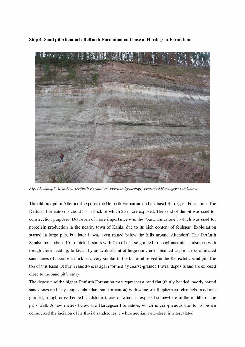
Stop 4: Sand pit Altendorf: Detfurth-Formation and base of Hardegsen-Formation:
Fig. 11: sandpit Altendorf: Detfurth-Formation overlain by strongly cemented Hardegsen sandstone.
The old sandpit in Alterndorf exposes the Detfurth Formation and the basal Hardegsen Formation. The
Detfurth Formation is about 35 m thick of which 20 m are exposed. The sand of the pit was used for
construction purposes. But, even of more importance was the “basal sandstone”, which was used for
porcelain production in the nearby town of Kahla, due to its high content of feldspar. Exploitation
started in large pits, but later it was even mined below the hills around Altendorf. The Detfurth
Sandstone is about 10 m thick. It starts with 2 m of coarse-grained to conglomeratic sandstones with
trough cross-bedding, followed by an aeolian unit of large-scale cross-bedded to pin-stripe laminated
sandstones of about 6m thickness, very similar to the facies observed in the Remschütz sand pit. The
top of this basal Detfurth sandstone is again formed by coarse-grained fluvial deposits and are exposed
close to the sand pit’s entry.
The deposits of the higher Detfurth Formation may represent a sand flat (thinly-bedded, poorly-sorted
sandstones and clay-drapes, abundant soil formation) with some small ephemeral channels (medium-
grained, trough cross-bedded sandstones), one of which is exposed somewhere in the middle of the
pit’s wall. A few metres below the Hardegsen Formation, which is conspicuous due to its brown
colour, and the incision of its fluvial sandstones, a white aeolian sand-sheet is intercalated.
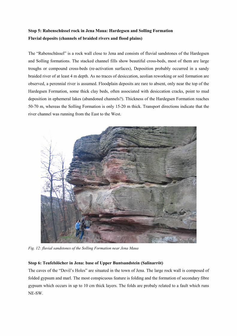
Stop 5: Rabenschüssel rock in Jena Maua: Hardegsen and Solling Formation
Fluvial deposits (channels of braided rivers and flood plains)
The “Rabenschüssel” is a rock wall close to Jena and consists of fluvial sandstones of the Hardegsen
and Solling formations. The stacked channel fills show beautiful cross-beds, most of them are large
troughs or compound cross-beds (re-activation surfaces), Deposition probably occurred in a sandy
braided river of at least 4 m depth. As no traces of desiccation, aeolian reworking or soil formation are
observed, a perennial river is assumed. Floodplain deposits are rare to absent, only near the top of the
Hardegsen Formation, some thick clay beds, often associated with desiccation cracks, point to mud
deposition in ephemeral lakes (abandoned channels?). Thickness of the Hardegsen Formation reaches
50-70 m, whereas the Solling Formation is only 15-20 m thick. Transport directions indicate that the
river channel was running from the East to the West.
Fig. 12: fluvial sandstones of the Solling Formation near Jena Maua
Stop 6: Teufelslöcher in Jena: base of Upper Buntsandstein (Salinarröt)
The caves of the “Devil’s Holes” are situated in the town of Jena. The large rock wall is composed of
folded gypsum and marl. The most conspicuous feature is folding and the formation of secondary fibre
gypsum which occurs in up to 10 cm thick layers. The folds are probaly related to a fault which runs
NE-SW.
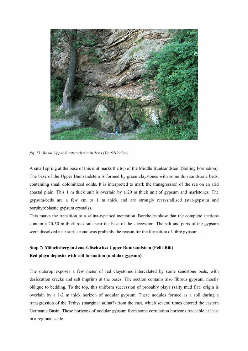
fig. 13: Basal Upper Buntsandstein in Jena (Teufelslöcher)
A small spring at the base of this unit marks the top of the Middle Buntsandstein (Solling Formation).
The base of the Upper Buntsandstein is formed by green claystones with some thin sandstone beds,
containing small dolomitized ooids. It is interpreted to mark the transgression of the sea on an arid
coastal plain. This 1 m thick unit is overlain by a 20 m thick unit of gypsum and marlstones. The
gypsum-beds are a few cm to 1 m thick and are strongly recrystallised (star-gypsum and
porphyroblastic gypsum crystals).
This marks the transition to a salina-type sedimentation. Boreholes show that the complete sections
contain a 20-50 m thick rock salt near the base of the succession. The salt and parts of the gypsum
were dissolved near surface and was probably the reason for the formation of fibre gypsum.
Stop 7: Mönchsberg in Jena-Göschwitz: Upper Buntsandstein (Pelit-Röt)
Red playa deposits with soil formation (nodular gypsum)
The outcrop exposes a few meter of red claystones intercalated by some sandstone beds, with
desiccation cracks and salt imprints at the bases. The section contains also fibrous gypsum, mostly
oblique to bedding. To the top, this uniform succession of probably playa (salty mud flat) origin is
overlain by a 1-2 m thick horizon of nodular gypsum. These nodules formed as a soil during a
transgression of the Tethys (marginal salina?) from the east, which several times entered the eastern
Germanic Basin. These horizons of nodular gypsum form some correlation horizons traceable at least
in a regional scale.
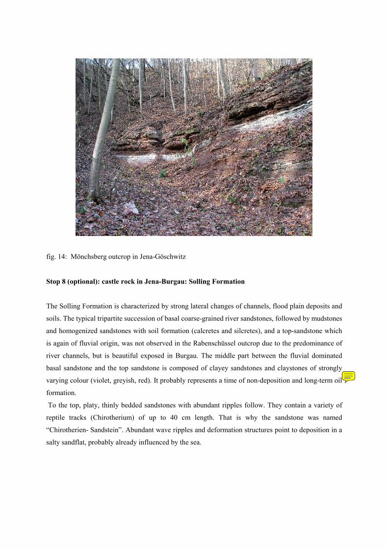
fig. 14: Mönchsberg outcrop in Jena-Göschwitz
Stop 8 (optional): castle rock in Jena-Burgau: Solling Formation
The Solling Formation is characterized by strong lateral changes of channels, flood plain deposits and
soils. The typical tripartite succession of basal coarse-grained river sandstones, followed by mudstones
and homogenized sandstones with soil formation (calcretes and silcretes), and a top-sandstone which
is again of fluvial origin, was not observed in the Rabenschüssel outcrop due to the predominance of
river channels, but is beautiful exposed in Burgau. The middle part between the fluvial dominated
basal sandstone and the top sandstone is composed of clayey sandstones and claystones of strongly
varying colour (violet, greyish, red). It probably represents a time of non-deposition and long-term oil
formation.
To the top, platy, thinly bedded sandstones with abundant ripples follow. They contain a variety of
reptile tracks (Chirotherium) of up to 40 cm length. That is why the sandstone was named
“Chirotherien- Sandstein”. Abundant wave ripples and deformation structures point to deposition in a
salty sandflat, probably already influenced by the sea.
karel
Lístek s poznámkou
soil
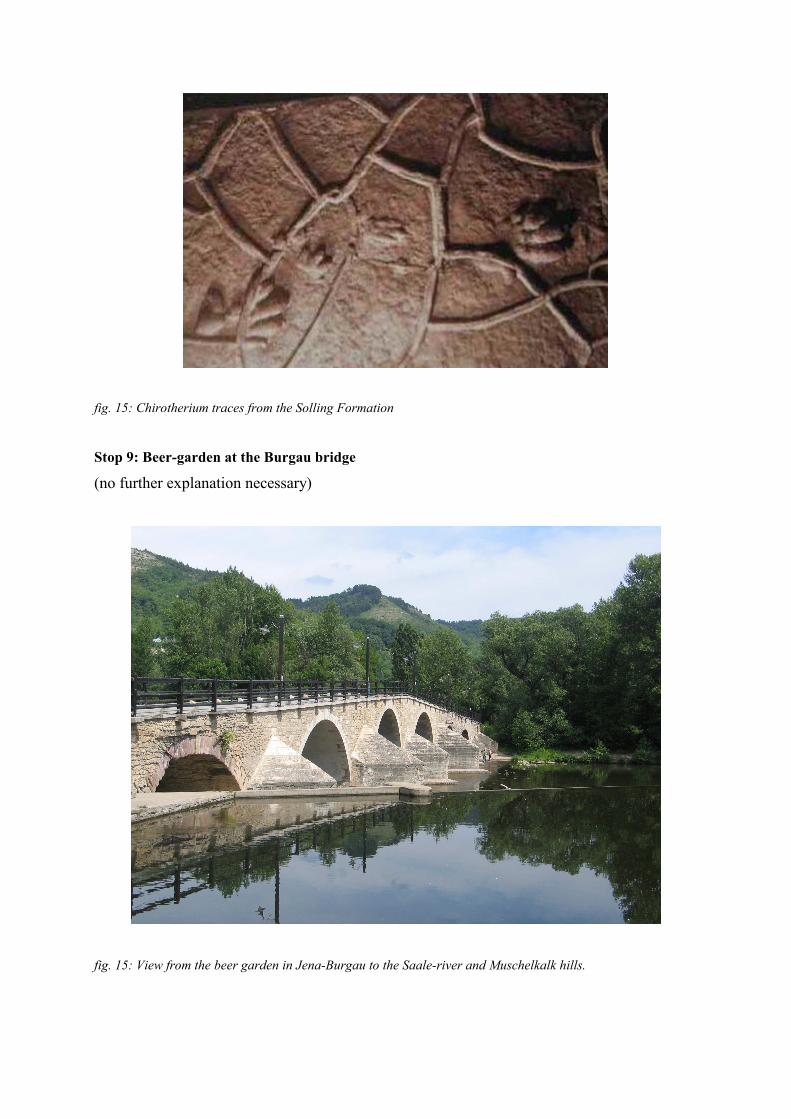
fig. 15: Chirotherium traces from the Solling Formation
Stop 9: Beer-garden at the Burgau bridge
(no further explanation necessary)
fig. 15: View from the beer garden in Jena-Burgau to the Saale-river and Muschelkalk hills.