2APPLICATION OF GIS DATA MODELLING FOR STONE ...
18
APPLICATION OF GIS DATA APPLICATION OF GIS DATA MODELLING FOR STONE AGGREGATE MODELLING FOR STONE AGGREGATE POTENTIAL POTENTIAL IN DALMATIA IN DALMATIA Željko Dedić (1) Ozren Hasan (1) Slobodan Miko (1) Boris Lukšić (1) Erli Kovačević (1) Željko Dedić (1) Ozren Hasan (1) Slobodan Miko (1) Boris Lukšić (1) Erli Kovačević (1) HRVATSKI GEOLOŠKI INSTITUT - CROATIAN GEOLOGICAL SURVEY (1) Croatian Geological Survey; Sachsova 2, Zagreb 10000, Croatia 7th International Scientific Conference on Modern Management of Mine Producing, Geology and Environmental Protection - SGEM 2007 HRVATSKI GEOLOŠKI INSTITUT - CROATIAN GEOLOGICAL SURVEY 11 JUNE - 15 JUNE 2007 ALBENA Co, BULGARIA
Transcript of 2APPLICATION OF GIS DATA MODELLING FOR STONE ...

APPLICATION OF GIS DATA APPLICATION OF GIS DATA MODELLING FOR STONE AGGREGATE MODELLING FOR STONE AGGREGATE
POTENTIAL POTENTIAL IN DALMATIAIN DALMATIA
Željko Dedić(1) Ozren Hasan(1) Slobodan Miko(1) Boris Lukšić(1)
Erli Kovačević(1)
Željko Dedić(1) Ozren Hasan(1) Slobodan Miko(1) Boris Lukšić(1)
Erli Kovačević(1)
HRVATSKI GEOLOŠKI INSTITUT - CROATIAN GEOLOGICAL SURVEY
(1) Croatian Geological Survey; Sachsova 2, Zagreb 10000, Croatia
7th International Scientific Conference on Modern Management of Mine Producing, Geology and Environmental Protection - SGEM
2007
HRVATSKI GEOLOŠKI INSTITUT - CROATIAN GEOLOGICAL SURVEY
11 JUNE - 15 JUNE 2007 ALBENA Co, BULGARIA
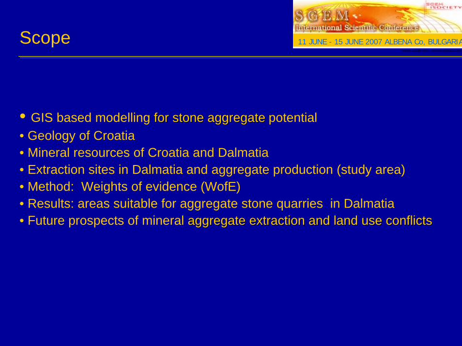
Scope
• GIS based modelling for stone aggregatefor stone aggregate potential• Geology of Croatia• Mineral resources of Croatia and Dalmatia • Extraction sites in Dalmatia and aggregate production (study area)• Method: Weights of evidence (WofE)• Results: areas suitable for aggregate stone quarries in Dalmatia• Future prospects of mineral aggregate extraction and land use conflictsaggregate extraction and land use conflicts
HRVATSKI GEOLOŠKI INSTITUT - CROATIAN GEOLOGICAL SURVEY
11 JUNE - 15 JUNE 2007 ALBENA Co, BULGARIA
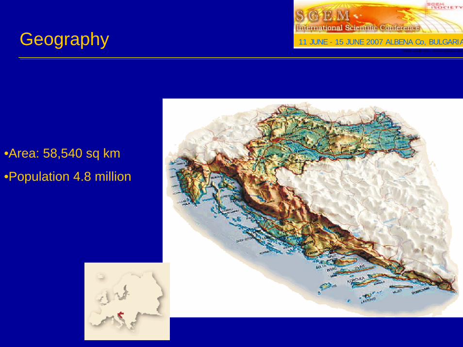
Geography
•Area: 58,540 sq km
•Population 4.8 million
HRVATSKI GEOLOŠKI INSTITUT - CROATIAN GEOLOGICAL SURVEY
11 JUNE - 15 JUNE 2007 ALBENA Co, BULGARIA
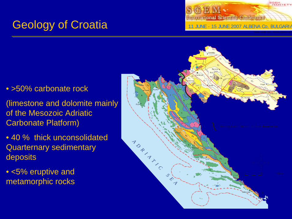
Geology of Croatia
A D R I A T I C S E A
Boundary between Carbonate and Non-carbonate terrains
• >50% carbonate rock
(limestone and dolomite mainlyof the Mesozoic AdriaticCarbonate Platform)
• 40 % thick unconsolidated Quarternary sedimentary deposits
• <5% eruptive and metamorphic rocks
HRVATSKI GEOLOŠKI INSTITUT - CROATIAN GEOLOGICAL SURVEY
11 JUNE - 15 JUNE 2007 ALBENA Co, BULGARIA

Mineral resources of Croatia
Mineral commodity:• crushed stone aggregate; 253 sites• dimension stone aggregate; 103 sites• sand and gravel; 82 sites• clay; 49 sites• bauxite ; 15 sites• gypsum; 9 sites• other non metal deposits• coal in the past
• 626 TOTAL NUMBER OF EXPLOATION SITES IN CROATIA (378 km²)
HRVATSKI GEOLOŠKI INSTITUT - CROATIAN GEOLOGICAL SURVEY
11 JUNE - 15 JUNE 2007 ALBENA Co, BULGARIA

• 68 active crushed stone aggregate quarries or 25 % in Dalmatia• 82 active dimension stone aggregate quarries or 80 % in Dalmatia
HRVATSKI GEOLOŠKI INSTITUT - CROATIAN GEOLOGICAL SURVEYHRVATSKI GEOLOŠKI INSTITUT - CROATIAN GEOLOGICAL SURVEY
11 JUNE - 15 JUNE 2007 ALBENA Co, BULGARIAQuarrying in Dalmatia

Quarrying in DalmatiaHRVATSKI GEOLOŠKI INSTITUT - CROATIAN GEOLOGICAL SURVEY
11 JUNE - 15 JUNE 2007 ALBENA Co, BULGARIA
• exploitative reserves of dimension stone aggregate13.5 mill. m³ in the study area• exploitative reserves of
crushed stone aggregate 350 mill. m³ in Croatia ( 25% in Dalmatia)• increasing demand for aggregate in EU, as well in Croatia
crushed stone aggregate
dimension stone aggregate

HRVATSKI GEOLOŠKI INSTITUT - CROATIAN GEOLOGICAL SURVEY
11 JUNE - 15 JUNE 2007 ALBENA Co, BULGARIA
Traces of old Roman quarries can be found along the coast, together with ruins of public buildings,basilicas and temples.
Today export destinations include Italy, Germany, Austria, Belgium, the Netherlands, Slovenia, Bosnia -Herzegovina, Czech Republic, UK, South Korea and Australia.
Limestones exclusive to the Dalmatia include Veselje, Adria Grigio, San Giorgio, Rasotica, Dracevica and Zecevo.
Quarrying in Dalmatia
Weights of evidence (WofE)HRVATSKI GEOLOŠKI INSTITUT - CROATIAN GEOLOGICAL SURVEY
11 JUNE - 15 JUNE 2007 ALBENA Co, BULGARIA
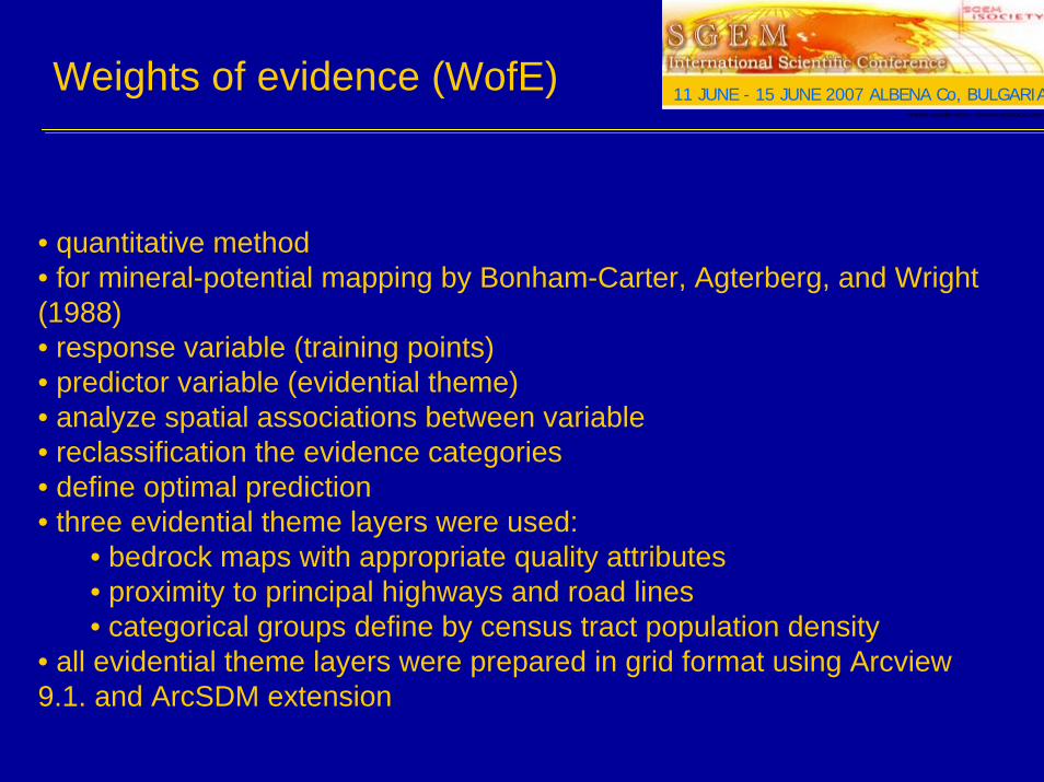
• quantitative method• for mineral-potential mapping by Bonham-Carter, Agterberg, and Wright (1988)• response variable (training points)• predictor variable (evidential theme)• analyze spatial associations between variable• reclassification the evidence categories• define optimal prediction• three evidential theme layers were used:
• bedrock maps with appropriate quality attributes• proximity to principal highways and road lines• categorical groups define by census tract population density
• all evidential theme layers were prepared in grid format using Arcview 9.1. and ArcSDM extension
HRVATSKI GEOLOŠKI INSTITUT - CROATIAN GEOLOGICAL SURVEY
11 JUNE - 15 JUNE 2007 ALBENA Co, BULGARIAWeights of evidence (WofE)
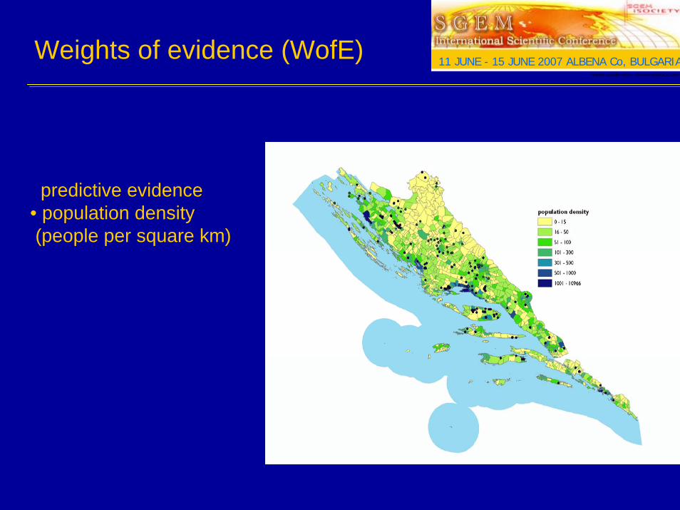
predictive evidence• population density (people per square km)

HRVATSKI GEOLOŠKI INSTITUT - CROATIAN GEOLOGICAL SURVEY
11 JUNE - 15 JUNE 2007 ALBENA Co, BULGARIAWeights of evidence (WofE)
• predictive evidence• transportaion network• distance from transportation corridors within 2 and 4 km• 90% crushed stone aggregate quarries are within 2 km of principal roads• the importance of proximity to transportation roads for the industry
HRVATSKI GEOLOŠKI INSTITUT - CROATIAN GEOLOGICAL SURVEY
11 JUNE - 15 JUNE 2007 ALBENA Co, BULGARIAWeights of evidence (WofE)
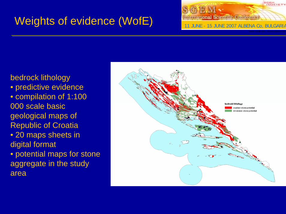
bedrock lithology• predictive evidence• compilation of 1:100 000 scale basic geological maps of Republic of Croatia• 20 maps sheets in digital format• potential maps for stone aggregate in the study area
HRVATSKI GEOLOŠKI INSTITUT - CROATIAN GEOLOGICAL SURVEY
11 JUNE - 15 JUNE 2007 ALBENA Co, BULGARIAResults
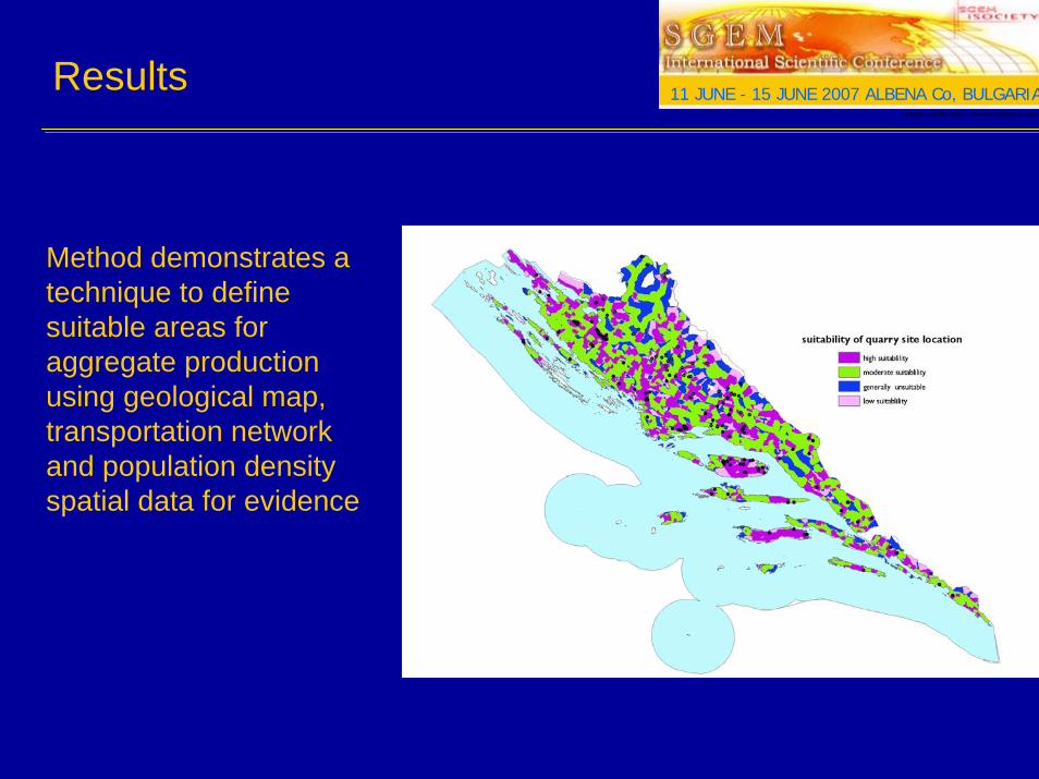
Method demonstrates a technique to define suitable areas for aggregate production using geological map, transportation network and population density spatial data for evidence

HRVATSKI GEOLOŠKI INSTITUT - CROATIAN GEOLOGICAL SURVEY
11 JUNE - 15 JUNE 2007 ALBENA Co, BULGARIAFuture prospects
To rise awareness to various mining problems and impacts on karst and to help manage better the use of mineral resources in Dalmatia based on identification of more suitable areas for stone production taking in account both environmental and marketplace restrictions and to help local environmental policy makers to correctly manage the fragile karst environment and to preserve the natural landscape.
HRVATSKI GEOLOŠKI INSTITUT - CROATIAN GEOLOGICAL SURVEY
11 JUNE - 15 JUNE 2007 ALBENA Co, BULGARIA
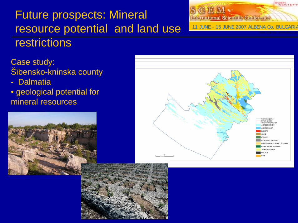
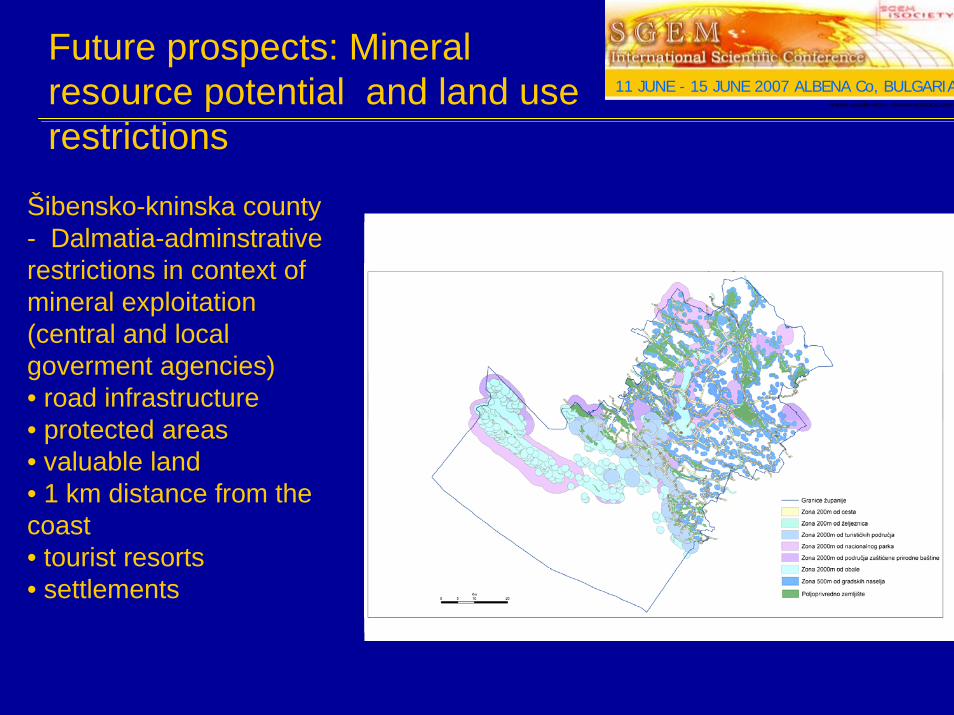
Future prospects: Mineral resource potential and land use restrictions
Case study:Šibensko-kninska county - Dalmatia• geological potential for mineral resources
HRVATSKI GEOLOŠKI INSTITUT - CROATIAN GEOLOGICAL SURVEY
11 JUNE - 15 JUNE 2007 ALBENA Co, BULGARIA
Šibensko-kninska county - Dalmatia-adminstrative restrictions in context of mineral exploitation (central and local goverment agencies)• road infrastructure• protected areas• valuable land• 1 km distance from the coast• tourist resorts• settlements
Future prospects: Mineral resource potential and land use restrictions
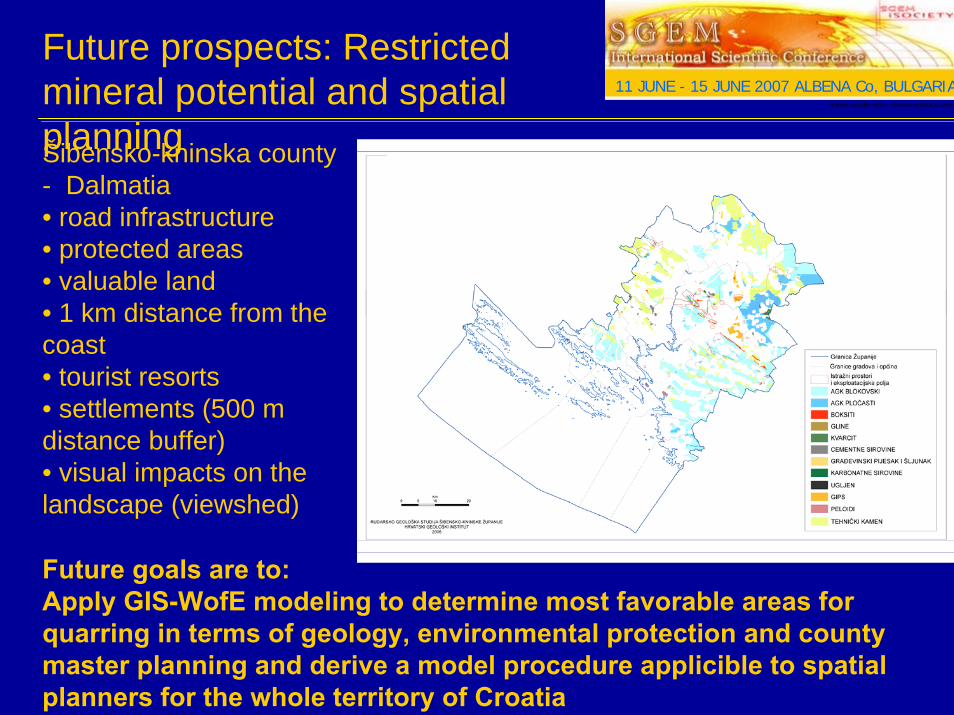
Future prospects: Restricted mineral potential and spatial planningŠibensko-kninska county - Dalmatia• road infrastructure• protected areas• valuable land• 1 km distance from the coast• tourist resorts• settlements (500 m distance buffer)• visual impacts on the landscape (viewshed)
HRVATSKI GEOLOŠKI INSTITUT - CROATIAN GEOLOGICAL SURVEY
11 JUNE - 15 JUNE 2007 ALBENA Co, BULGARIA
Future goals are to:Apply GIS-WofE modeling to determine most favorable areas for quarring in terms of geology, environmental protection and county master planning and derive a model procedure applicible to spatial planners for the whole territory of Croatia
Thank youThank you !!