29 October 2010 APA Ohio, Cleveland Section Jason Boyd Director Lake County Planning Commission
36
29 October 2010 APA Ohio, Cleveland Section Jason Boyd Director Lake County Planning Commission Northeast Ohio Planning and Zoning Workshop 25 June 2010 E L C C T Eastern Lake County Coastal Tributaries E L C C T Eastern Lake County Coastal Tributaries
-
Upload
ahmed-carson -
Category
Documents
-
view
20 -
download
1
description
29 October 2010 APA Ohio, Cleveland Section Jason Boyd Director Lake County Planning Commission. Northeast Ohio Planning and Zoning Workshop 25 June 2010. LOCAL PARTNERS. Chagrin River Watershed Partners, Inc. STATE PARTNERS. OHIO’S BALANCED GROWTH PLAN 101 - PowerPoint PPT Presentation
Transcript of 29 October 2010 APA Ohio, Cleveland Section Jason Boyd Director Lake County Planning Commission
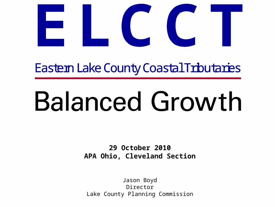
29 October 2010APA Ohio, Cleveland Section
Jason BoydDirector
Lake County Planning Commission
Northeast Ohio Planning and Zoning Workshop
25 June 2010E L C C TEastern Lake County Coastal Tributaries
E L C C TEastern Lake County Coastal Tributaries
LOCAL PARTNERS
Chagrin River Watershed Partners, Inc.
E L C C TEastern Lake County Coastal Tributaries
E L C C TEastern Lake County Coastal Tributaries

STATE PARTNERS
E L C C TEastern Lake County Coastal Tributaries
E L C C TEastern Lake County Coastal Tributaries
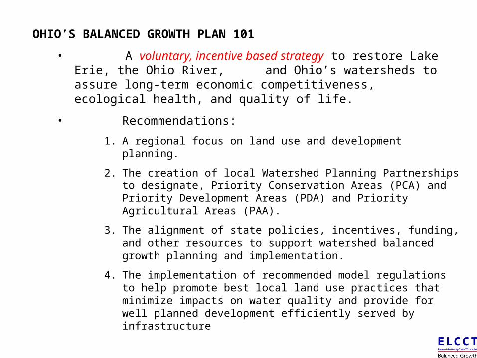
OHIO’S BALANCED GROWTH PLAN 101
• A voluntary, incentive based strategy to restore Lake Erie, the Ohio River, and Ohio’s watersheds to assure long-term economic competitiveness, ecological health, and quality of life.
• Recommendations:
1. A regional focus on land use and development planning.
2. The creation of local Watershed Planning Partnerships to designate, Priority Conservation Areas (PCA) and Priority Development Areas (PDA) and Priority Agricultural Areas (PAA).
3. The alignment of state policies, incentives, funding, and other resources to support watershed balanced growth planning and implementation.
4. The implementation of recommended model regulations to help promote best local land use practices that minimize impacts on water quality and provide for well planned development efficiently served by infrastructure
The fundamental principle to guide the actions of state agencies is that if local governments can agree on areas where development is to be encouraged (PDAs) and areas which are to be conserved (PCAs), the State of Ohio will align state programs to support these locally based decisions and conversely will not utilize state programs to violate them.
E L C C TEastern Lake County Coastal Tributaries
E L C C TEastern Lake County Coastal Tributaries
E L C C TEastern Lake County Coastal Tributaries
E L C C TEastern Lake County Coastal Tributaries
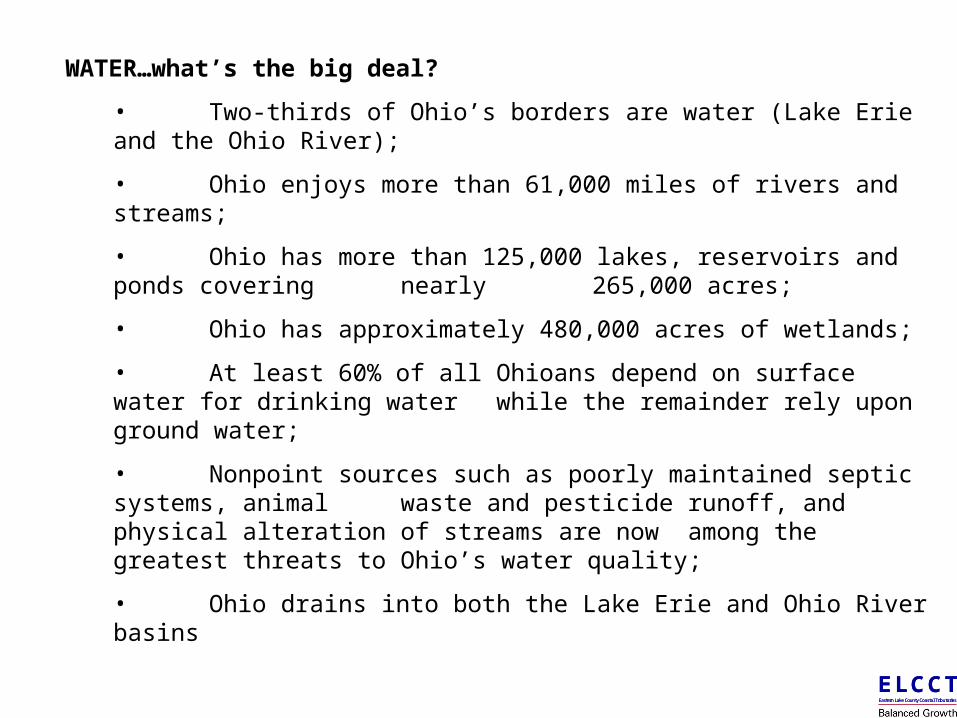
WATER…what’s the big deal?
• Two-thirds of Ohio’s borders are water (Lake Erie and the Ohio River);
• Ohio enjoys more than 61,000 miles of rivers and streams;
• Ohio has more than 125,000 lakes, reservoirs and ponds covering nearly 265,000 acres;
• Ohio has approximately 480,000 acres of wetlands;
• At least 60% of all Ohioans depend on surface water for drinking water while the remainder rely upon ground water;
• Nonpoint sources such as poorly maintained septic systems, animal waste and pesticide runoff, and physical alteration of streams are now among the greatest threats to Ohio’s water quality;
• Ohio drains into both the Lake Erie and Ohio River basins
E L C C TEastern Lake County Coastal Tributaries
E L C C TEastern Lake County Coastal Tributaries
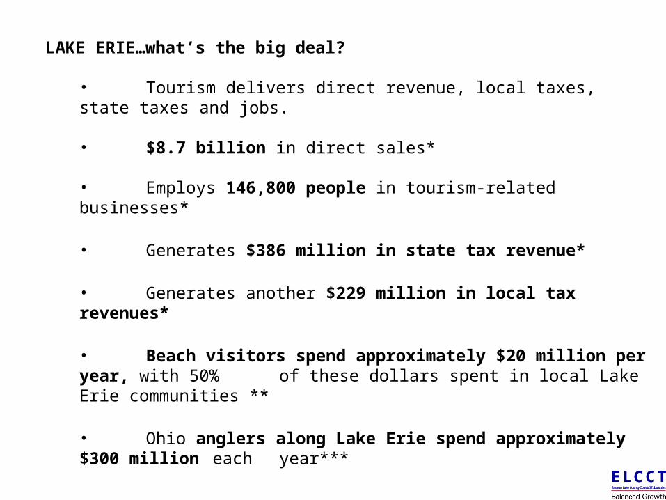
LAKE ERIE…what’s the big deal? • Tourism delivers direct revenue, local taxes, state taxes and jobs.
• $8.7 billion in direct sales*
• Employs 146,800 people in tourism-related businesses*
• Generates $386 million in state tax revenue*
• Generates another $229 million in local tax revenues*
• Beach visitors spend approximately $20 million per year, with 50% of these dollars spent in local Lake Erie communities **
• Ohio anglers along Lake Erie spend approximately $300 million each year***
*Lake Erie Tourism Economic Impact Report, Longwoods International/Rovelstad and Associates, 2005, economic impact study of tourism in Ashtabula, Lake, Cuyahoga, Lorain, Erie, Ottawa and Lucas counties.** The Economics of Lake Erie Beach Users 1998, OSU Ohio Sea Grant *** ODNR Division of Wildlife and American Sportfishing Association
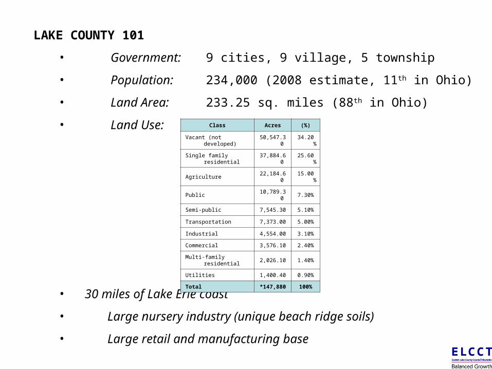
LAKE COUNTY 101
• Government: 9 cities, 9 village, 5 township
• Population: 234,000 (2008 estimate, 11th in Ohio)
• Land Area: 233.25 sq. miles (88th in Ohio)
• Land Use:
• 30 miles of Lake Erie coast
• Large nursery industry (unique beach ridge soils)
• Large retail and manufacturing base
Class Acres (%)
Vacant (not developed)
50,547.30
34.20%
Single family residential
37,884.60
25.60%
Agriculture22,184.6
015.00
%
Public10,789.3
07.30%
Semi-public 7,545.30 5.10%
Transportation 7,373.00 5.00%
Industrial 4,554.00 3.10%
Commercial 3,576.10 2.40%
Multi-family residential 2,026.10 1.40%
Utilities 1,400.40 0.90%
Total*147,88
0100%
E L C C TEastern Lake County Coastal Tributaries
E L C C TEastern Lake County Coastal Tributaries
E L C C TEastern Lake County Coastal Tributaries
E L C C TEastern Lake County Coastal Tributaries
E L C C TEastern Lake County Coastal Tributaries
E L C C TEastern Lake County Coastal Tributaries
E L C C TEastern Lake County Coastal Tributaries
E L C C TEastern Lake County Coastal Tributaries
E L C C TEastern Lake County Coastal Tributaries
E L C C TEastern Lake County Coastal Tributaries
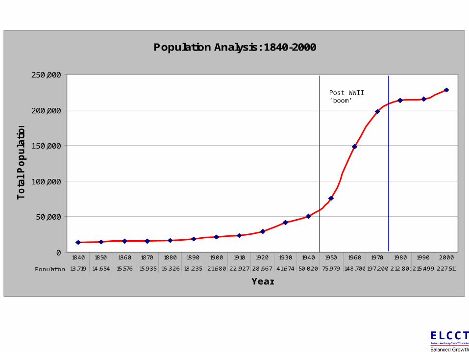
Population Analysis: 1840-2000
0
50,000
100,000
150,000
200,000
250,000
Year
To
tal
Po
pu
lati
on
Population 13,719 14,654 15,576 15,935 16,326 18,235 21,680 22,927 28,667 41,674 50,020 75,979 148,700197,200 212,801215,499 227,511
1840 1850 1860 1870 1880 1890 1900 1910 1920 1930 1940 1950 1960 1970 1980 1990 2000
Post WWII ‘boom’
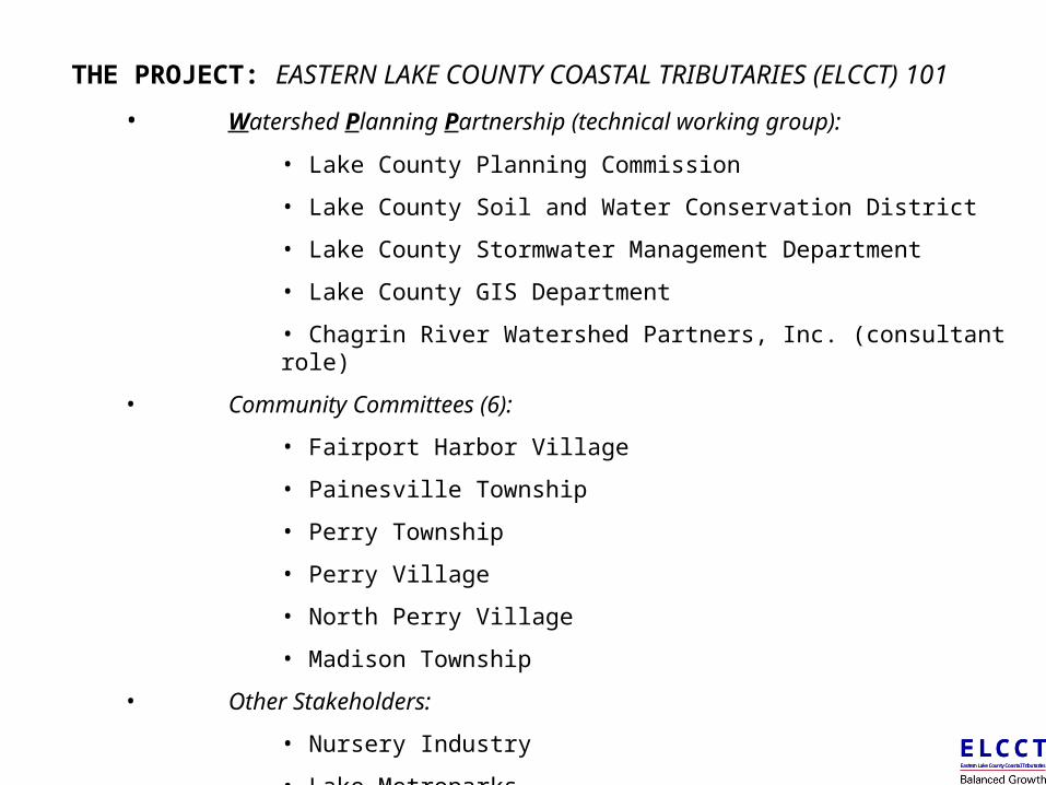
THE PROJECT: EASTERN LAKE COUNTY COASTAL TRIBUTARIES (ELCCT) 101
• Watershed Planning Partnership (technical working group):
• Lake County Planning Commission
• Lake County Soil and Water Conservation District
• Lake County Stormwater Management Department
• Lake County GIS Department
• Chagrin River Watershed Partners, Inc. (consultant role)
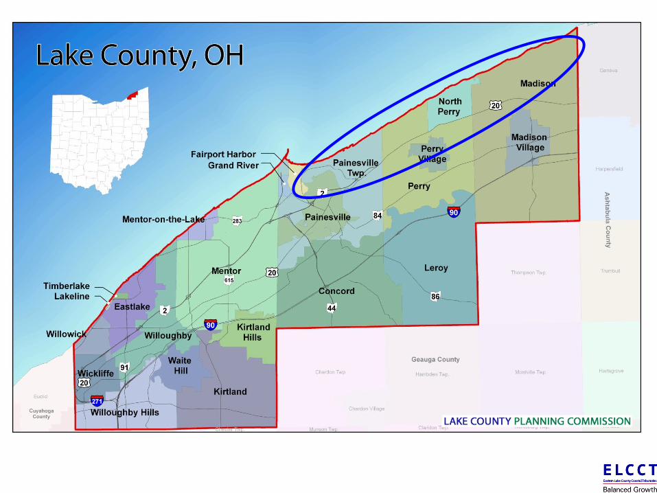
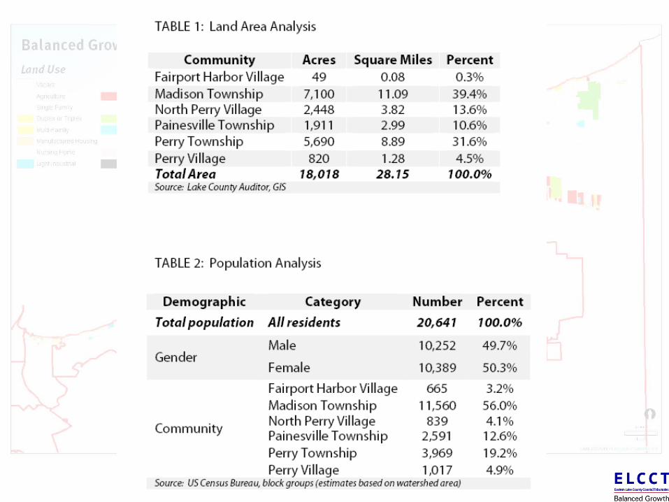
• Community Committees (6):
• Fairport Harbor Village
• Painesville Township
• Perry Township
• Perry Village
• North Perry Village
• Madison Township
• Other Stakeholders:
• Nursery Industry
• Lake Metroparks
E L C C TEastern Lake County Coastal Tributaries
E L C C TEastern Lake County Coastal Tributaries
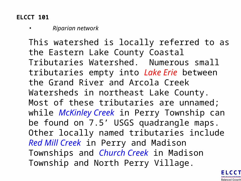
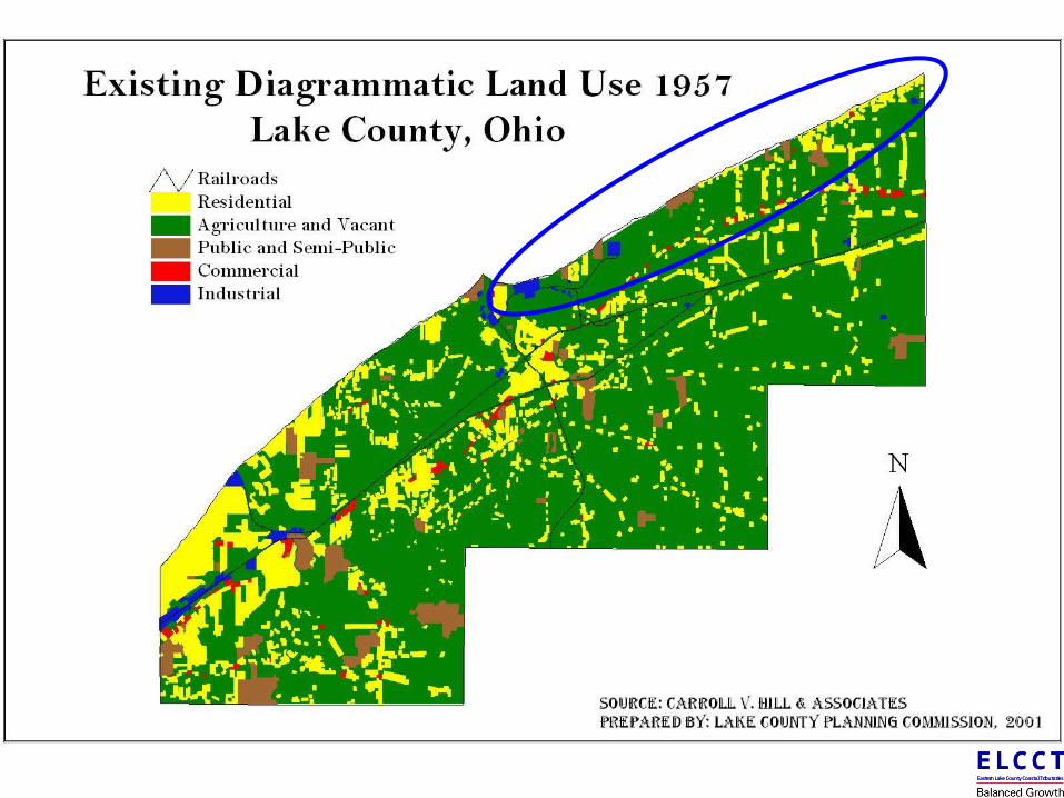
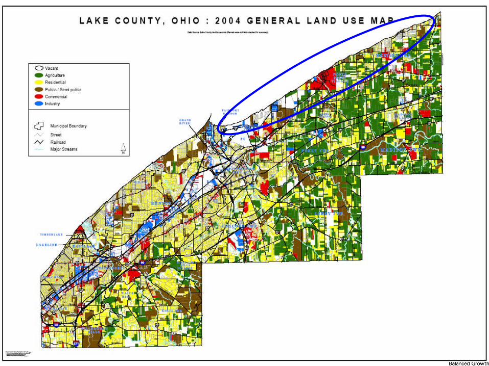
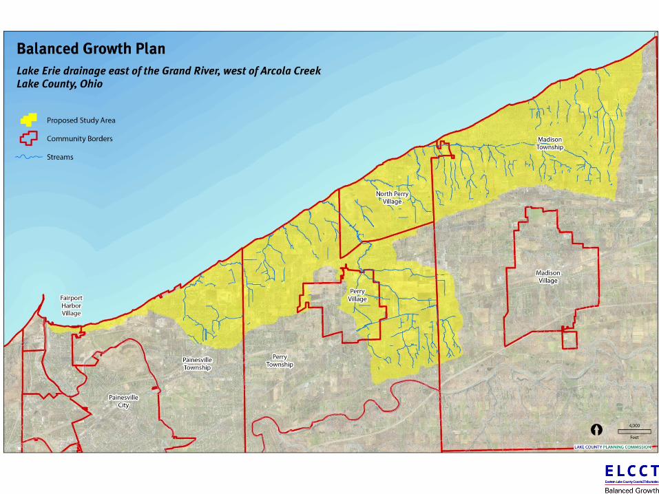
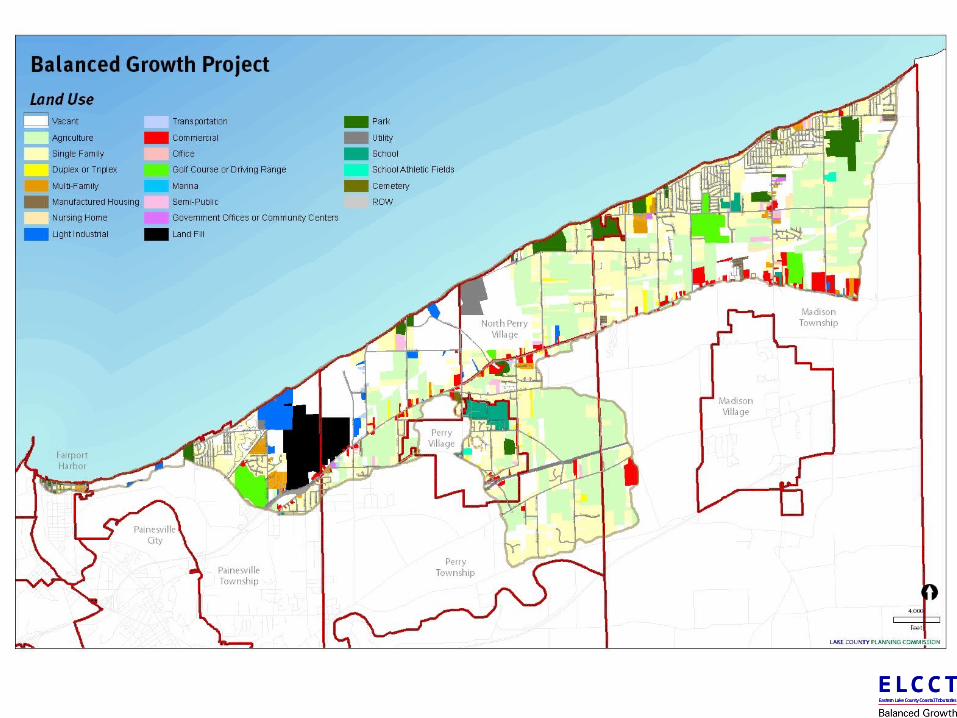
ELCCT 101
• Riparian network
This watershed is locally referred to as the Eastern Lake County Coastal Tributaries Watershed. Numerous small tributaries empty into Lake Erie between the Grand River and Arcola Creek Watersheds in northeast Lake County. Most of these tributaries are unnamed; while McKinley Creek in Perry Township can be found on 7.5’ USGS quadrangle maps. Other locally named tributaries include Red Mill Creek in Perry and Madison Townships and Church Creek in Madison Township and North Perry Village.
E L C C TEastern Lake County Coastal Tributaries
E L C C TEastern Lake County Coastal Tributaries
E L C C TEastern Lake County Coastal Tributaries
E L C C TEastern Lake County Coastal Tributaries
E L C C TEastern Lake County Coastal Tributaries
E L C C TEastern Lake County Coastal Tributaries
E L C C TEastern Lake County Coastal Tributaries
E L C C TEastern Lake County Coastal Tributaries
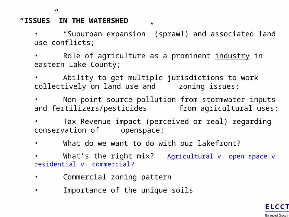
“ISSUES” IN THE WATERSHED
• “Suburban expansion” (sprawl) and associated land use conflicts;
• Role of agriculture as a prominent industry in eastern Lake County;
• Ability to get multiple jurisdictions to work collectively on land use and zoning issues;
• Non-point source pollution from stormwater inputs and fertilizers/pesticides from agricultural uses;
• Tax Revenue impact (perceived or real) regarding conservation of openspace;
• What do we want to do with our lakefront?
• What’s the right mix? Agricultural v. open space v. residential v. commercial?
• Commercial zoning pattern
• Importance of the unique soils
E L C C TEastern Lake County Coastal Tributaries
E L C C TEastern Lake County Coastal Tributaries
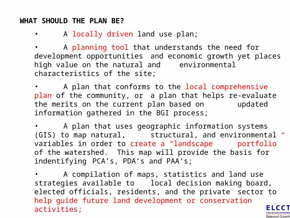
WHAT SHOULD THE PLAN BE?
• A locally driven land use plan;
• A planning tool that understands the need for development opportunities and economic growth yet places high value on the natural and environmental characteristics of the site;
• A plan that conforms to the local comprehensive plan of the community, or a plan that helps re-evaluate the merits on the current plan based on updated information gathered in the BGI process;
• A plan that uses geographic information systems (GIS) to map natural, structural, and environmental variables in order to create a “landscape portfolio” of the watershed. This map will provide the basis for indentifying PCA’s, PDA’s and PAA’s;
• A compilation of maps, statistics and land use strategies available to local decision making board, elected officials, residents, and the private sector to help guide future land development or conservation activities;
• A tool to bring multiple communities together to address common variables, concerns and strategies associated with long-term land use and its impact on the communities, region, and watershed.
E L C C TEastern Lake County Coastal Tributaries
E L C C TEastern Lake County Coastal Tributaries
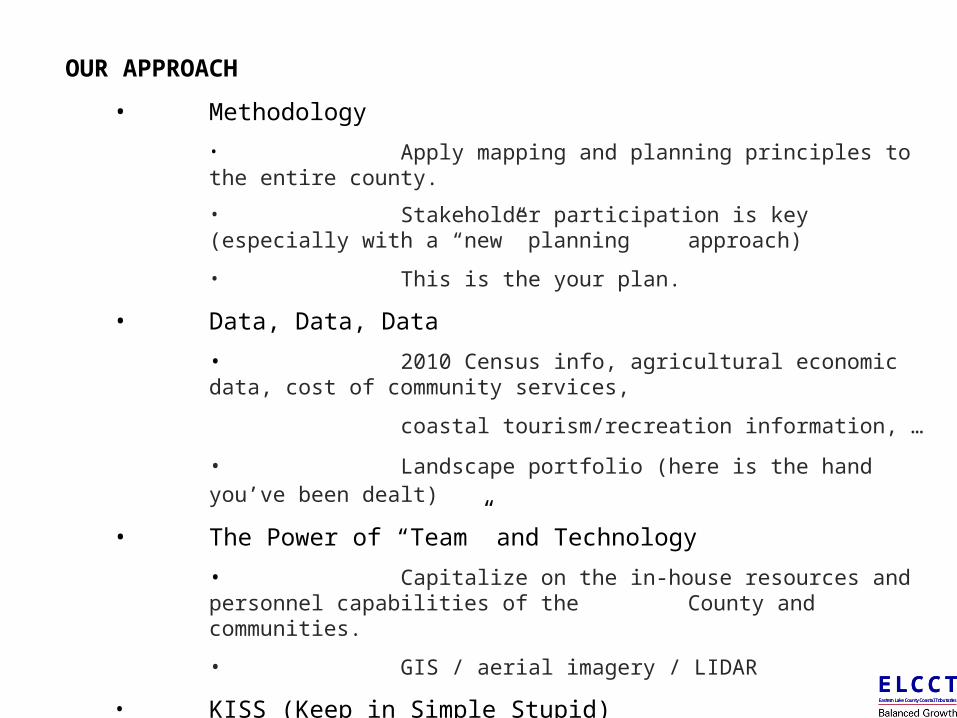
OUR APPROACH
• Methodology
• Apply mapping and planning principles to the entire county.
• Stakeholder participation is key (especially with a “new” planning approach)
• This is the your plan.
• Data, Data, Data
• 2010 Census info, agricultural economic data, cost of community services,
coastal tourism/recreation information, …
• Landscape portfolio (here is the hand you’ve been dealt)
• The Power of “Team” and Technology
• Capitalize on the in-house resources and personnel capabilities of the County and communities.
• GIS / aerial imagery / LIDAR
• KISS (Keep in Simple Stupid)
• The project, from start to finish, must be easily understood by the citizenry to be accepted and ultimately implemented.
E L C C TEastern Lake County Coastal Tributaries
E L C C TEastern Lake County Coastal Tributaries
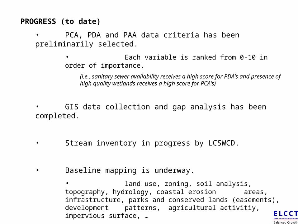
PROGRESS (to date)
• PCA, PDA and PAA data criteria has been preliminarily selected.
• Each variable is ranked from 0-10 in order of importance.
(i.e., sanitary sewer availability receives a high score for PDA’s and presence of high quality wetlands receives a high score for PCA’s)
• GIS data collection and gap analysis has been completed.
• Stream inventory in progress by LCSWCD.
• Baseline mapping is underway.
• land use, zoning, soil analysis, topography, hydrology, coastal erosion areas, infrastructure, parks and conserved lands (easements), development patterns, agricultural activitiy, impervious surface, …
• Community committees are formed or in the process of forming.
• Existing PC/ZC, elected officials or new committees
E L C C TEastern Lake County Coastal Tributaries
E L C C TEastern Lake County Coastal Tributaries
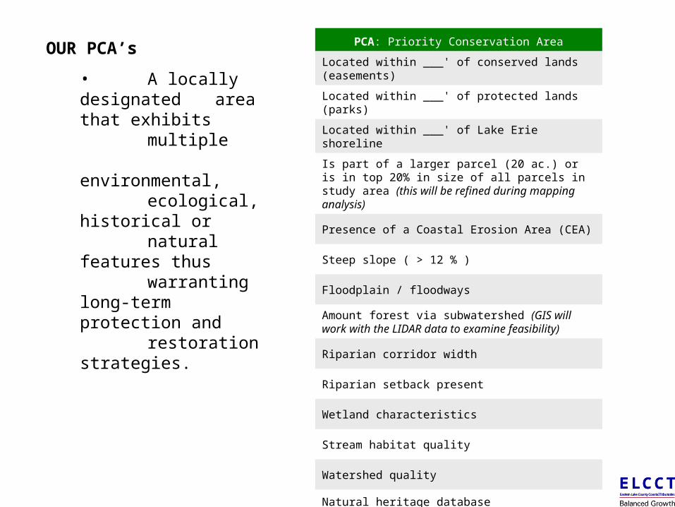
OUR PCA’s
• A locally designated area that exhibits multiple environmental, ecological, historical or
natural features thus warranting long-term
protection and restoration
strategies.
E L C C TEastern Lake County Coastal Tributaries
E L C C TEastern Lake County Coastal Tributaries
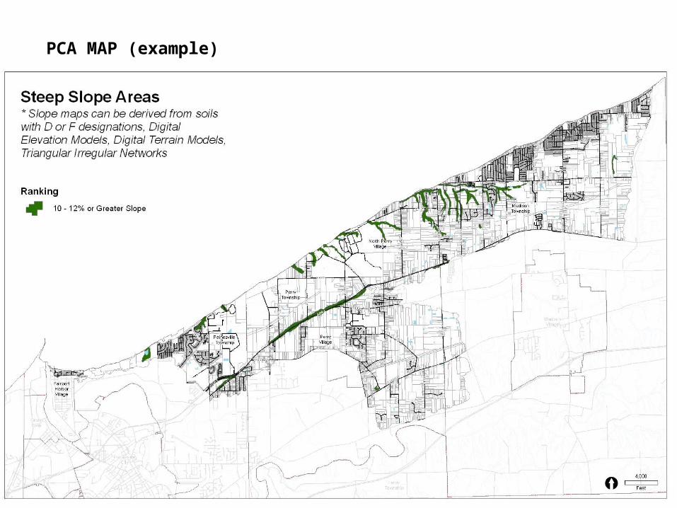
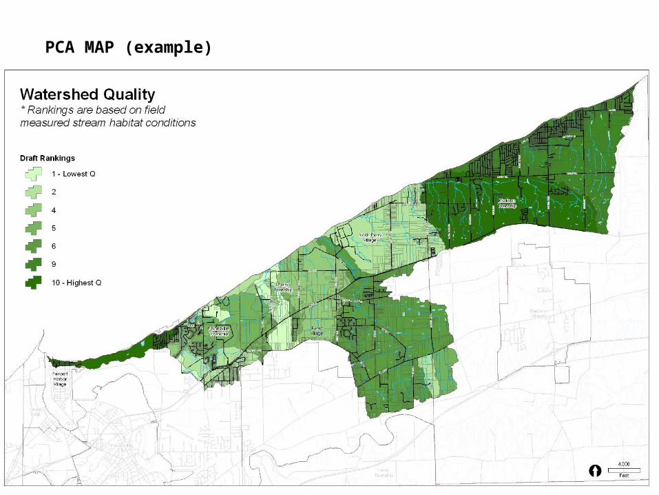
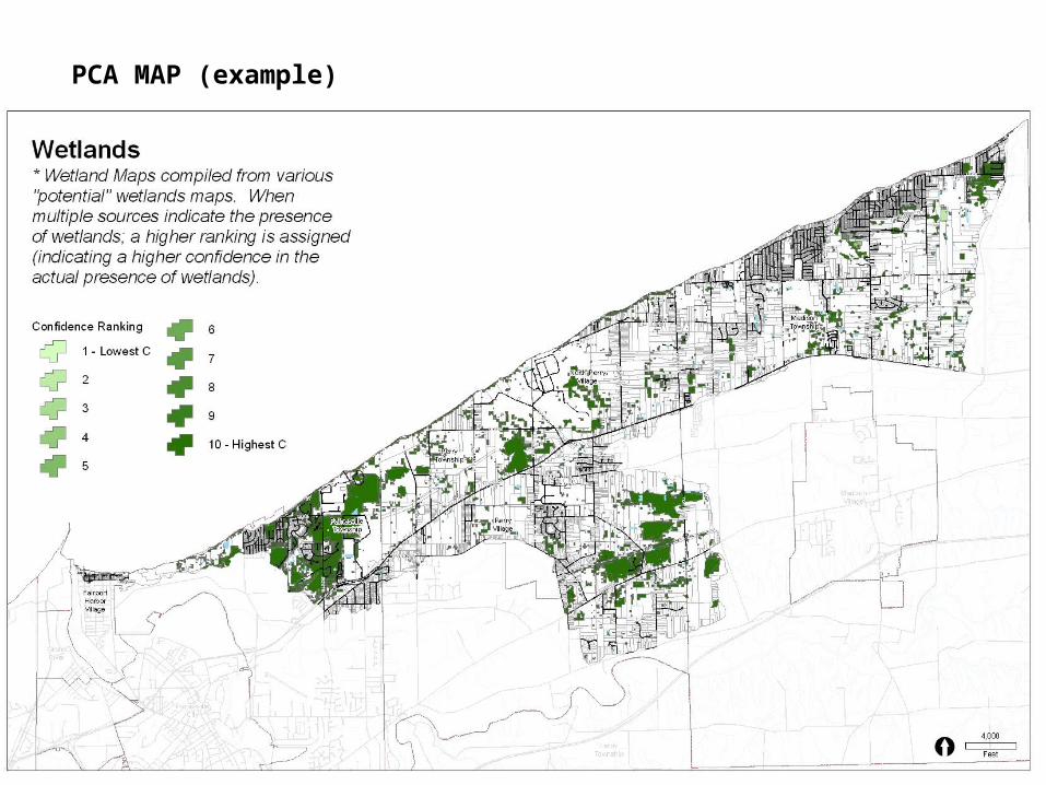
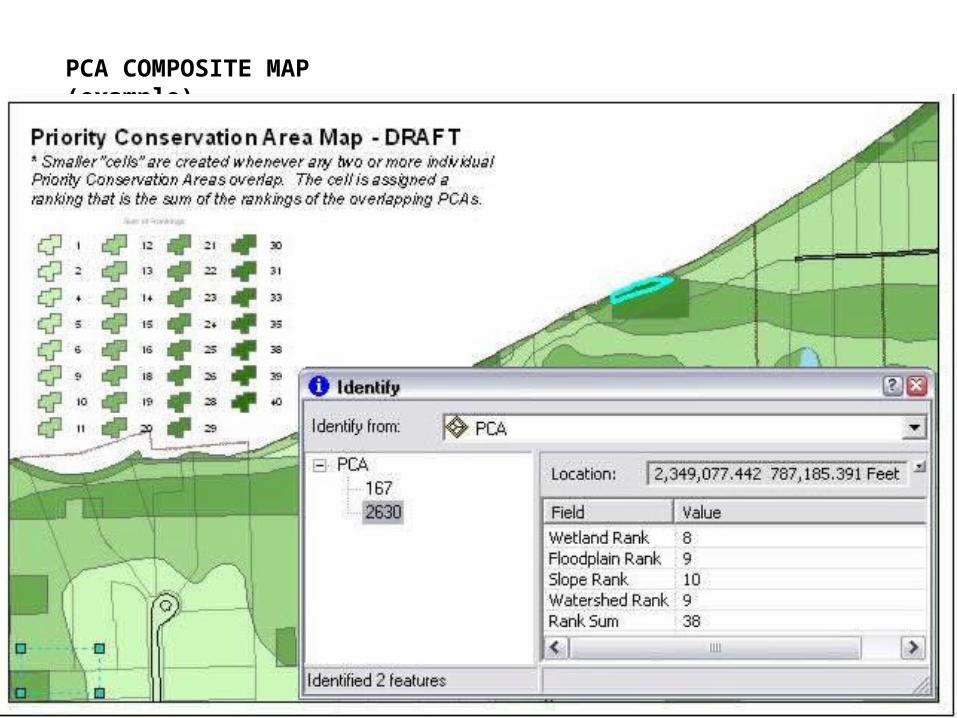
PCA: Priority Conservation Area
Located within ___' of conserved lands (easements)
Located within ___' of protected lands (parks)
Located within ___' of Lake Erie shoreline
Is part of a larger parcel (20 ac.) or is in top 20% in size of all parcels in study area (this will be refined during mapping analysis)
Presence of a Coastal Erosion Area (CEA)
Steep slope ( > 12 % )
Floodplain / floodways
Amount forest via subwatershed (GIS will work with the LIDAR data to examine feasibility)
Riparian corridor width
Riparian setback present
Wetland characteristics
Stream habitat quality
Watershed quality
Natural heritage database
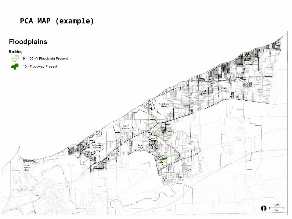
PCA MAP (example)
E L C C TEastern Lake County Coastal Tributaries
E L C C TEastern Lake County Coastal Tributaries
PCA MAP (example)
E L C C TEastern Lake County Coastal Tributaries
E L C C TEastern Lake County Coastal Tributaries
PCA MAP (example)
E L C C TEastern Lake County Coastal Tributaries
E L C C TEastern Lake County Coastal Tributaries
PCA MAP (example)
E L C C TEastern Lake County Coastal Tributaries
E L C C TEastern Lake County Coastal Tributaries
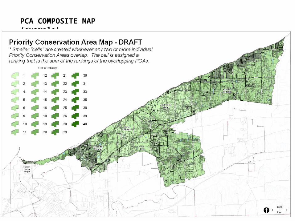
PCA COMPOSITE MAP (example)
E L C C TEastern Lake County Coastal Tributaries
E L C C TEastern Lake County Coastal Tributaries
PCA COMPOSITE MAP (example)
E L C C TEastern Lake County Coastal Tributaries
E L C C TEastern Lake County Coastal Tributaries
OUR PDA’s
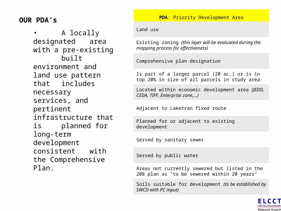
• A locally designated area with a pre-existing built environment and land use pattern that includes necessary services, and pertinent infrastructure that is planned for long-term development consistent
with the Comprehensive Plan.
E L C C TEastern Lake County Coastal Tributaries
E L C C TEastern Lake County Coastal Tributaries
PDA: Priority Development Area
Land use
Existing zoning (this layer will be evaluated during the mapping process for effectiveness)
Comprehensive plan designation
Is part of a larger parcel (20 ac.) or is in top 20% in size of all parcels in study area.
Located within economic development area (JEDD, CEDA, TIFF, Enterprise zone,…)
Adjacent to Laketran fixed route
Planned for or adjacent to existing development
Served by sanitary sewer
Served by public water
Areas not currently sewered but listed in the 208 plan as "to be sewered within 20 years"
Soils suitable for development (to be established by SWCD with PC input)
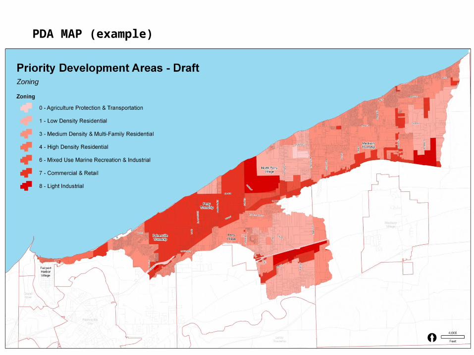
PDA MAP (example)
E L C C TEastern Lake County Coastal Tributaries
E L C C TEastern Lake County Coastal Tributaries
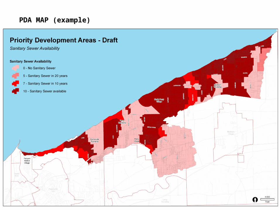
PDA MAP (example)
E L C C TEastern Lake County Coastal Tributaries
E L C C TEastern Lake County Coastal Tributaries
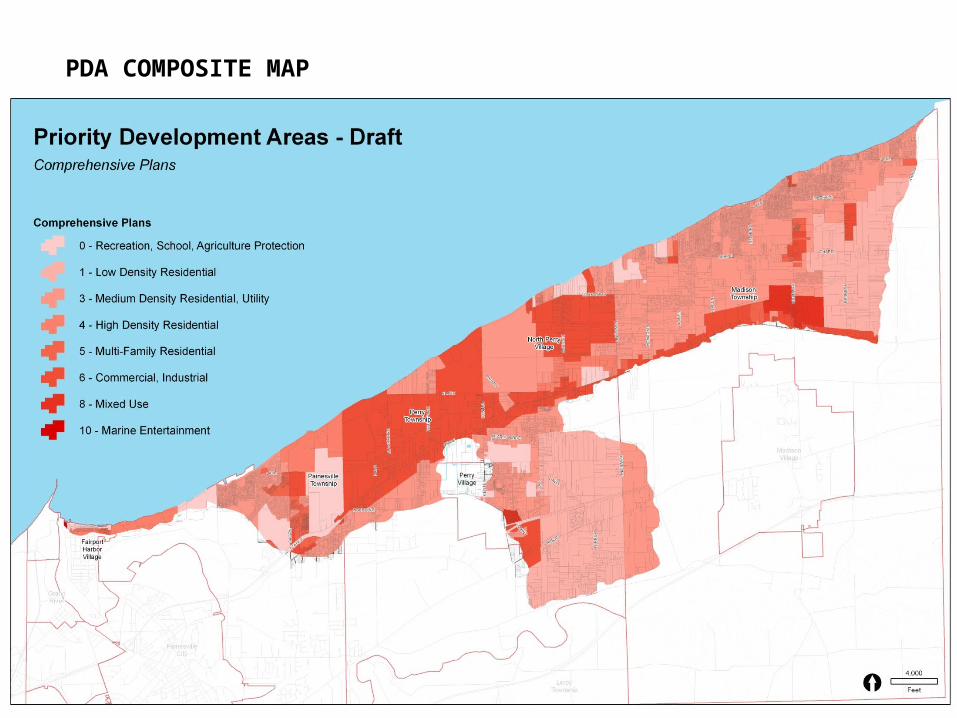
PDA COMPOSITE MAP (example)
E L C C TEastern Lake County Coastal Tributaries
E L C C TEastern Lake County Coastal Tributaries
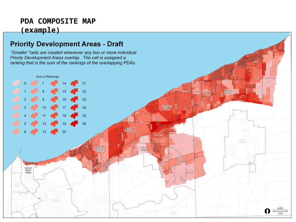
PDA COMPOSITE MAP (example)
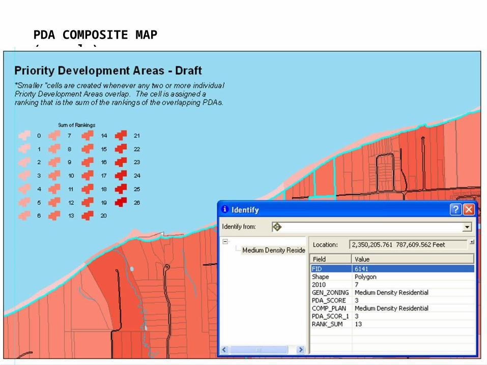
PDA COMPOSITE MAP (example)
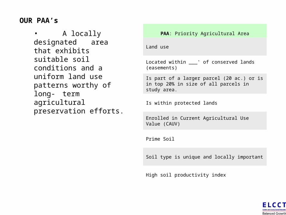
OUR PAA’s
• A locally designated area that exhibits suitable soil conditions and a
uniform land use patterns worthy
of long- term agricultural preservation
efforts.
E L C C TEastern Lake County Coastal Tributaries
E L C C TEastern Lake County Coastal Tributaries
PAA: Priority Agricultural Area
Land use
Located within ___' of conserved lands (easements)
Is part of a larger parcel (20 ac.) or is in top 20% in size of all parcels in study area.
Is within protected lands
Enrolled in Current Agricultural Use Value (CAUV)
Prime Soil
Soil type is unique and locally important
High soil productivity index
NOW WHAT?
• Individual community meetings will ramp up this fall as data collection is completed and base mapping is finalized.
• Landscape portfolio of the watershed will be presented to all committees and local stakeholders.
• Using the portfolio, local committees will begin the preliminary identification of PCA, PDA and PAA’s.
• Overall WPP will serve as a technical guidance committee during this process.
• Multiple meetings may be necessary to form a consensus.
• Designations should be in conformance with the Comprehensive Plan or provide a rationale as to a necessary change to the Plan based on data discovered during the BGI process.
• Plan preparation (recommendations and strategies) will begin simultaneously with community mapping.
• Plan and PCA, PDA and PAA maps will be presented to the elected officials for adoption.
E L C C TEastern Lake County Coastal Tributaries
E L C C TEastern Lake County Coastal Tributaries
E L C C TEastern Lake County Coastal Tributaries
E L C C TEastern Lake County Coastal Tributaries
QUESTIONS?