236 THE AMERICAN ALPINE JOURNAL AFRICAc498469.r69.cf2.rackcdn.com/1977/asia1977_236-284.pdf ·...
49
236 THE AMERICAN ALPINE JOURNAL and towers offer scrambles, but in winter the Sar provide remarkable ski- mountaineering. The mountains of grass and scree become headwalls, ridges, long slopes of powder snow, chutes hundreds of meters long and gleaming with ice, great cornices, frost feathers a meter long. The Sar can be as good as anything you can find. STANLEYS.SHEPARD AFRICA Mount Kenya and Hell’s Gate Crag. Paul Braithwaite and I spent four weeks in East Africa. We visited Hell’s Gate Crag with the local hard-man, Ian Howell, who took us up the classic route of the crag Olympian. I managed to free-climb the pegging pitches. Braithwaite and I then went off to Mount Kenya and made a new direct route up the steep northeast face via the Grey Pillar. We made the climb in 15 hours with a bivouac midway up the route on continuously clean jam-cracks. Back at Hell’s Gate we teamed up with the other local hard-man, Ian Allen and put up two more new routes. During the last week we returned to Mount Kenya and climbed the fabulous Diamond Couloir via the steep headwall and continued on up to the Gate of the Mist and then to the top of Bastian, the highest point of Mount Kenya. We descended via Nelion and the Shipton route in a continuous 14-hour day. I wish to call attention to the earlier ascent of the whole of the Diamond Couloir by the American Phil Snyder and the local Vikuyu, Corporal Thumbi. Although Chouinard and Covington traversed off, the other two continued on up. DOUGLAS SCOTT, Alpine Climbing Group ASIA Nepal Jannu, North Face Attempt. A very strong New Zealand party at- tempted the 10,500-foot north face of Jannu (25,295 feet) in the fall of 1975. The 17-day approach began in August. Base Camp was placed at 14,800 feet on September 7. The route-finding began with exploration of a 3000-foot-high icefall and the rock buttress beside it. Although ways were forced through both, the buttress, with Camp I halfway up, proved better. Bad weather plagued them. Camp II was established at 18,000 feet by October 1 on the snowfield above the icefall. A 600- foot nearly vertical gully led to a system of ice gullies and an ice spur at 20,000 feet. Then vertical rock rose to steep ice and snow that led to the jagged summit ridge. Jim Strang and Geoff Wayatt made an
Transcript of 236 THE AMERICAN ALPINE JOURNAL AFRICAc498469.r69.cf2.rackcdn.com/1977/asia1977_236-284.pdf ·...

236 THE AMERICAN ALPINE JOURNAL
and towers offer scrambles, but in winter the Sar provide remarkable ski- mountaineering. The mountains of grass and scree become headwalls, ridges, long slopes of powder snow, chutes hundreds of meters long and gleaming with ice, great cornices, frost feathers a meter long. The Sar can be as good as anything you can find.
STANLEYS.SHEPARD
AFRICA
Mount Kenya and Hell’s Gate Crag. Paul Braithwaite and I spent four weeks in East Africa. We visited Hell’s Gate Crag with the local hard-man, Ian Howell, who took us up the classic route of the crag Olympian. I managed to free-climb the pegging pitches. Braithwaite and I then went off to Mount Kenya and made a new direct route up the steep northeast face via the Grey Pillar. We made the climb in 15 hours with a bivouac midway up the route on continuously clean jam-cracks. Back at Hell’s Gate we teamed up with the other local hard-man, Ian Allen and put up two more new routes. During the last week we returned to Mount Kenya and climbed the fabulous Diamond Couloir via the steep headwall and continued on up to the Gate of the Mist and then to the top of Bastian, the highest point of Mount Kenya. We descended via Nelion and the Shipton route in a continuous 14-hour day. I wish to call attention to the earlier ascent of the whole of the Diamond Couloir by the American Phil Snyder and the local Vikuyu, Corporal Thumbi. Although Chouinard and Covington traversed off, the other two continued on up.
DOUGLAS SCOTT, Alpine Climbing Group
ASIA
Nepal
Jannu, North Face Attempt. A very strong New Zealand party at- tempted the 10,500-foot north face of Jannu (25,295 feet) in the fall of 1975. The 17-day approach began in August. Base Camp was placed at 14,800 feet on September 7. The route-finding began with exploration of a 3000-foot-high icefall and the rock buttress beside it. Although ways were forced through both, the buttress, with Camp I halfway up, proved better. Bad weather plagued them. Camp II was established at 18,000 feet by October 1 on the snowfield above the icefall. A 600- foot nearly vertical gully led to a system of ice gullies and an ice spur at 20,000 feet. Then vertical rock rose to steep ice and snow that led to the jagged summit ridge. Jim Strang and Geoff Wayatt made an

CLIMBS AND EXPEDITIONS 237
alpine-style attack on October 9 to 12. After two bivouacs, while Wayatt waited at Camp IV, Strang forced his way to a co1 just below the summit ridge at 23,500 feet. After their return to Base Camp, both had to be helicoptered out to Kathmandu with frostbite. Meanwhile the others had been working out a safer route to the left. On October 16, Bryan Pooley, Don Jowett, Graeme Dingle, Peter Farrell and Lynn Crawford started a final push. Pooley and Crawford left a Camp V on the 19th, but a howling gale turned them back after they had reached the summit ridge at 24,000 feet. For a full account, see Climbing of May-June, 1976, pages 27-31.
Jannu, North Face. The sixteen-man Japanese Sangaku Doshikai Expedition, led by Masatsugu Konishi climbed the extremely difficult north face of Jannu (25,295 feet), getting four teams of 13 Japanese and three Sherpas to the summit. The other three members were pre- vented from getting there only by bad weather. They followed the route pioneered to within 1300 feet of the top by New Zealanders in 1975. (See above.) The route was almost exactly the same as that of the New Zealanders and in many cases the Japanese found the New Zealanders’ protection. The party divided into four teams and took turns rotating at route finding, route preparation, load carrying and resting. Thus they made continuous progress. Base Camp at 14,750 feet was set up on March 15. Camp I was at 16,600 feet above the first icefall, which they had avoided on rocks to its right. Camp II was at 18,000 feet on the snowfield. The really difficult climbing began above there on March 25. The New Zealanders’ pitons and slings were no longer dependable. Camp III was established at 20,350 feet on April 10. They then worked left under the hanging glacier and climbed the ice wall to pitch Camp IV at 21,325 feet on the 14th. Camp V was placed on April 24 at the foot of the red tower on the shoulder of the east ridge at 23,450 feet. A vertical chimney had to be climbed before pitching Camp VI on May 9 at 24,275 feet. After a day of route preparation, on May 11 Nobuyuki Ogawa, Naoe Sakashita and Shomi Suzuki climbed to the top in six-and-a-half hours. On the 12th the leader Konishi, Masaru Samba, Kazuyoshi Konno and two Sherpas ascended the peak, followed the next day by Seiichi Kawamura, Kiyomi Kawakami and Toshio Akiyma. On the 14th Ryoichi Kukada, Kazushi Katahira, Toshiro Jofu, Dr. Toshitaka Sakano and a Sherpa reached the top. The weather turned bad on the 15th, preventing the other three from climbing. Before the start of the expedition Keiichi Oki tried to “acclimatize” fast. He flew to Lukla at 9000 feet and went on to Thangboche at 12,500 feet the next day and to Pheriche at 14,100 feet the day after. On the fourth day he climbed a 5000-meter peak, fell victim to high-altitude sickness on the fifth day and died on the sixth.

238 THE AMERICAN ALPINE JOURNAL
Makalu, Fifth Ascent by Czechoslovakian and Spanish Expeditions. The Czechoslovakian expedition was led by Ivan Galfy and composed of Jaromir Wolf, Dr. Leo; Chlldek, Vlado OndruS, FrantiSek Dostal, Zdenek Brabec, Jan cervinka, Ivan Fiala, Milan KriSSak, Milo Neumann, Igor NovBk, Michal Orolin, Josef Psotka, Leo PBleniEek, Vlado Petrik, Milo Pelt, Karel Schubert and Sylva Talla. On March 20 they set up their Base Camp below the 8000-foot-high southwest buttress, which they had attempted in 1973. The Spanish expedition was led by Jo& Marid Montfort. They were Antonio Bahi, Dr. Armando Redondo, Jo& and Juan Lleonart, Enrique Bonastre, Jorge Camprubi, Ram& Maj6, Juan Frontera, Franz Anton Ludwig, Antonio Llasera, Jorge Vinyoli and Jo& Salvans. They set up their Base Camp at 15,780 feet on April 5 below the southeast ridge, hoping to make the second ascent . of the southeast-ridge route of 1970. The Czechoslovaks quickly set up Camps I, II and III where they had been in 1973 but storms sent them back to Base. On May 3 Camp V was occupied at 25,750 feet. On the 4th Talla and Petrik set out for the southeast summit (26,280 feet). They had to climb a lOO-foot rock wall before reaching this foresummit at 1:30 P.M. (The Japanese had reached here in 1970 via the southeast ridge during the second ascent of the mountain.) Petrik got frostbitten feet and had to be evacuated to Kathmandu. The plan was to continue to the main summit along the Japanese route, which they joined there, and to place Camp VI in the saddle between the southeast and main summits. Talla and Orolin made a summit attempt but reached only 26,900 feet. The Spaniards now at 24,350 feet made an agreement with the Czechs: one Spaniard would accompany the Czechs to the summit and the latter would descend the easier Spanish route on the southeast ridge. The high camp was pushed to 26,900 feet. On May 24 Orolin, KriSSak, Schubert and the Spaniard Jordi Camprubi set out. The climb- ing was difficult and they fixed 1000 feet of rope. They traversed 650 feet at 27,225 feet to join the French 1971 west-ridge route. They found fixed ropes on a 130-foot rock wall, left probably by the Japanese, French or Yugoslavian south-face team on their 1975 fourth ascent. Orolin’s oxygen apparatus failed and he returned from there to the high camp. At 4:30 P.M. the other three reached the summit (27,809 feet). The weather became very severe. They descended separately. KriSSak got back to Camp VI at seven and Camprubi at ten that evening. At nine A.M. they tried to go upwards and made contact with Schubert, presum- ably by shouting with him at the traverse, but then he was no longer heard. They were too exhausted to go farther up. It is likely that he had fallen down the south face. Orolin was suffering from thrombosis. He could descend only to Camp V that day and had to be evacuated. (We are grateful to Anders Bolinder for this information, which he in turn received from the Czechoslovakian climbers.)

CLIMBS AND EXPEDITIONS 239
Kangchungtse. Kangchungtse or Makalu II (25,066 feet) was climbed by an expedition of the Seppyo Alpine Club of Japan led by Yasukawa Shuji. They climbed the northwest ridge. The summit was reached by Satoshi Nara and Sherpa Lakpu Norbu on October 13 from Camp IV at 23,635 feet.
MICHAEL CHENEY, Himalayan Club
Lhofse atternpf. The Japanese Kanagawa Alpine Association Expedi- tion which attempted a new route, the southwest ridge of Lhotse (27,890 feet), was led by Kanji Kamei. The highest point reached was 24,935 feet. The highest camp was Camp III at 23,800 feet although there was a small “advance camp” at 23,950 feet. A Camp IV was planned for 25,525 feet but this site was not reached. The expedition was defeated by heavy snowfall.
MICHAEL J. CHENEY, Himalayan Club
Everest, British and Nepalese. The Joint British and Royal Nepalese Army Expedition was led by Lieutenant Colonel Tony Streather and composed of 34 members. We made a successful ascent following the route of the first ascent via the Khumbu Glacier and the South Co1 during the pre-monsoon season. We walked in during March and had a period of climbing based on Pheriche. Advanced Base (Camp II) was sited adjacent to the previous expeditions’ camp on April 7. Captain Terry Thompson fell into a crevasse there on April 11 and was killed. The weather deteriorated in April and the build-up was slow. The South Co1 was reached on May 4. Our large team did much of its own carry- ing and only ten high-altitude Sherpas were hired. Seventeen members and eight Sherpas carried to the South Col. Only members climbed above the co1 and ten of them carried to Camp VI on the site of the 1963 American camp at 27,500 feet. Sergeant J.H. Stokes and Corporal M.P. Lane sat out a storm at Camp VI on May 14 and 15. They climbed to the summit at 3: 15 on May 16. They were benighted and had to bivouac during the descent. Both suffered frostbite. They have since lost twenty toes and five fingers between them.
MAJOR M.W. HENRY DAY, Royal Engineers, British Army
Manaslu. A joint Iranian-Japanese expedition was led by Brigadier General Mohammed Khakbiz and Noboyoshi Tamura. They climbed the east face of Manaslu (26,760 feet) by the same route as the Japanese Ladies’ Expedition of 1974. On October 12 Lieutenant Mohammed Jaffar Assadi (Iran) and Jun Kagayama (Japan) and Pasang Sherpa reached the summit from Camp V at 24,800 feet.
MICHAEL CHENEY, Hirnalaynn Club

240 THE AMERICAN ALPINE JOURNAL
Manaslu Attempt. A IV-man South Korean team left Kathmandu in mid-March to attempt the east ridge of Manaslu (26,760 feet), pre- viously tried by two other Korean expeditions. During the two unsuc- cessful attempts of 1971 and 1972, sixteen including two brothers of the Kim family, Ki Sup Kim and Ho Sup Kim, lost their lives and the youngest, Ye Sup Kim, was seriously injured by an avalanche and rescued after 30 hours. The eldest brother, Jung Sup Kim, led the third expedition. Camps were set up at 17,050, 19,000, 21,325 and 23,950 feet on April 5, 10, 22 and 27 respectively. While Camp V was being pitched at 25,600 feet on May 5, it was hit by an avalanche. The leader, Jung Sup Kim, was hit in the chest by an ice block. Sardar Dawang Chuk and two other Sherpas were buried but came out without injuries. The over-all leader and climbing leader, Kyoung Bae Kim, were air-lifted to Kathmandu. The expedition was abandoned after an unsuccessful attempt on May 12.
KAMAL K. GUHA, Himalayan Club
Lamjung. A Japanese expedition from the Kochi Mountaineering Federation was led by Shizuo Kunisawa. This was the third ascent, the peak having been climbed twice in 1974. It was ascended by the east ridge. Base Camp at 11,800 feet, Camp I at 15,425 feet and Camp II at 17,725 feet were established on April I, 7 and 19. Hiroo Wada, Soichi Takeda, Kemichi Kiyoka and Kazuo Yamoto left Camp IV at 21,150 feet at 5:30 on April 28. After a seven-hour climb they reached the summit (22,910 feet). The next day the peak was climbed by Chusei Irimagiri, Seizi Yamamoto, Hiroshi Kawada and Sherpas Ming Tenzing and Chepa. On April 30 the top was reached by Tsuneo Komatsu, Isamu Tozaki, Shoziro Morito, Kenichi Narahira, Yasumi Ujihara, Toichi Nozimo and Sherpa Ang Dorji. They had hoped to climb the virgin south peak of 22,740 feet, just south of the main peak, climbing over the latter, but they did not receive permission for this.
KAMAL K. GUHA, Himalayan Club
Glacier Dome. Rheinhold Messner led a 16-member Austro-German group to attempt Glacier Dome (24,556 feet) from the south. However, this was really a “high-level tourist trek” of mostly elderly men and women. The only camp was established at 16,000 feet. There was no serious attempt to reach the summit.
MICHAEL J. CHENEY, Himalayan Club
Curia Himal. A seven-member French expedition from Alsace left Pokhara on March 29 and arrived at Base Camp at 13,550 feet on

CLIMBS AND EXPEDITIONS 241
April 9. Camps I, II, and III were set up at 15,325, 17,525, and 18,300 feet on April 12, 16, and 20 respectively. Camp IV was at 22,300 feet. On May 5 Christine Ertlen, sister of the leader, FranGois Soubrane and Maurice Schoenahl reached the summit (23,592 feet), following the French route of 1972. They descended the Japanese route of 1969. Mile Ertlen fell as she was adjusting her crampons and pulled the other two off. Soubrane was instantly killed and Schoenahl broke ribs. Mlle Ertlen was in a coma for two days from which she never emerged. The second summit team, Philippe Ertlen, leader, Bernard Aghina and Jean- Claude Laubacher had climbed to Camp IV that same day and hearing cries, went to give help. Schoenahl managed to climb down with the others. Dr. Jacques Sisslcr was the seventh member.
KAMAL K. GUHA, Himalayan Club
Annapuma IV, So~trll Face. Pit Schubert led a German expedition to the South face of Annapurna IV (24,688 feet) and with Heinz Baumann reached the summit and survived after a most amazing adven- ture. The other members of the expedition were Dr. Werner Goltzsche, Ernst Mahner, Riidiger Steuer, Udo Pohlke and Dr. Karl van Sambeek. The party reached Base Camp on April 30 at 1 1,350 feet below the vast snow basin flanked by Annapurna IV, Annapurna 11 and Lamjung Himal, which makes UP the south face. There was a difficult icefall between Base Camp and Camp I at 13,775 feet. It took three days to prepare the route and they fixed much rope there. Camp II was estab- lished on May 6 at 16,500 feet under protecting cliffs but they felt wind blasts from nearby avalanches, which fell when there was new snow. Above were steep rocks where they fixed ropes and then a steep av- alanche-swept slope. While the rest wanted to work out a route to the right, Schubert and Baumann thought it only practical to climb the remaining 8000 vertical feet alpine-style more directly upward. These two carried loads higher and then on May 10 set out. They soon lost radio contact. When by May 20 they had not returned, their com- panions gave them up for dead and evacuated Base Camp. Meanwhile the summit pair were working their way upward. On May 10 they climbed the rock, crossed the avalanche slope above and ascended an icefall and snow ridge to camp at 18,550 feet. They brought up supplies from their dump just below and sorted out what they thought they needed for a quick climb to the summit. On both May 11 and 12 they climbed some 1650 feet and on the 13th another 500 feet. At 22,300 feet they felt close to the top, but it took them another five days. They were caught in a windslab avalanche from which Schubert had to be dug out; they had route-finding difficulties; they had to hole LIP in bad weather for a day; food and fuel ran out. The final push started on

242 THE AMERICAN ALPINE JOURNAL
May 17. After a frigid night in a bivouac sack, despite Schubert’s frozen feet, they reached the summit on May 18. On the night of May 19 they managed to get back to supplies left at Camp III and could eat again. The weather turned bad and avalanches nearly dragged them off as they staggered downwards. The fixed ropes below Camp I had been removed by the porters. Base Camp had been evacuated only five hours before their arrival. It took two more days to descend to the first village; Schubert suffered terribly walking on his frozen feet. He has since lost many of his toes.
Annapurna South. The Hong Kong Expedition consisted of members of the British Forces serving in Hong Kong. We were Duncan Briggs, Bill Noble, Rick Bond, Li Nai Chung, Martin Callaghan, Rinchen Wangdi Lepchha, Dhaubahadur Pun, Subrabahadur Rai and I as leader, all either British or Gurkha soldiers. To reach Base Camp in the sanc- tuary we used 82 porters. Above we did all the carrying ourselves. We climbed the east face and set up five camps, plus a bivouac on the summit bid. Base Camp was in a grassy valley at 14,500 feet adjacent to the main Annapurna Glacier. To get to Camp I we followed the main glacier to gain the far lateral moraine of a subsidiary glacier blocking the route. Camp I was on the moraine. We reached Camp II by follow- ing the moraine and then abseiling into the upper reaches of the sub- sidiary glacier, where at 17,000 feet we placed Camp II. From II to III we climbed a short steep ridge to get to a spot below the east face proper. The angle steepened as we had to climb a stepped snow-and-ice ridge, fixing ropes in places, to gain Camp IV at 20,500 feet below a 100-foot ice cliff. From there we reached the top of the ridge and made Camp V at 21,500 feet. A further 1000 feet of the face remained before we could reach the main Annapurna ridge, along which we hoped easily to reach the summit. By this time there were three of us, which made it slow, and we bivouacked at 22,500 feet. On November 3 Duncan Briggs, Rinchen Wangdi Lepchha and I got to the summit ridge in a vicious wind. The wind slowed our progress but we reached the summit at one P.M.
PETER COOPER, Captain, Royal Engineers
Tukche Peak. The second all-Nepalese expedition was outstandingly well organized and executed by the Nepalese Police. It was led by Superintendent Govinda Krishna Shrestha. They climbed Tukche Peak (22,707 feet) from the west. Base Camp was established on September 13 at 16,675 feet, Camp I on the 16th at 18,200 feet and Camp II on the 20th at 19,525 feet. On October 2 nine members, four of them Sherpas, climbed to the top from Camp III at 21,000 feet.
MICHAEL CHENEY, Himalayan Club

CLIMBS AND EXPEDITIONS 243
Putha Hiunchuli. A six-man team led by Kenichi Shindo abandoned its attempt on the virgin west ridge of Putha Hiunchuli (23,774 feet) on November 1. They had left Kathmandu on August 27 and set up Base Camp on the Dogari Khola. Camps I and II were set up at 16,400 and 18,050 feet on September 24 and 30 respectively.
KAMAL K. GUHA, Himalayan Club
Dhaulagiri. A 12-man Italian expedition led by Renzo De Bertolis made the fourth ascent of Dhaulagiri (26,795 feet). Although they had hoped to climb the northwest ridge, they followed the route climbed by all the others, the northeast ridge. They left Pokhara on March 5 and made a supply dump at 12,150 feet under the west face on March 17. Base Camp was finally completed at 15,125 feet below the north face on March 26. Camp I was placed at 17,725 feet on April 5 and Camp II on the northeast co1 on the 9th. Camp III at 21,650 feet was pitched on April 19 and Camp IV at 23,300 feet on the 27th. Ropes were fixed between these last two camps. Above Camp IV they found what they described as very difficult rock and ice. Camp V was established at 24,700 feet on May 3. On May 4 Giampaolo Zortea, Silvio Simoni and Luciano Gadenz set out for the summit. Gadenz had to turn back because of threatened frostbite well below the top. The other two reached the summit at 2:30 P.M. All camps were evacuated by May 6, luckily enough since on May 8 a colossal avalanche swept over where Camps I and II had been. The other members of the expedition were Francesco Santon, Camillo and Giampaolo De Paoli, Sergio Martini, Giampietro Scalet, Edoardo Zagonel, Luigino Henry and Dr. Achille Poluzzi.
Kaniiroba Main Peak. The Hong Kong Expedition comprised Ron Giddy, Dave Holdroyd and me, together with two Sherpas and a liaison officer. We flew by charter plane to Jumla on September 18, walked five days east to the village of Hurikot and from there took the approach up the Jagdula Khola, attempted by John Tyson’s 1961 and 1964 parties. This involved several river crossings and steep grass and earth slopes. We established Base Camp at 13,300 feet on the site used by the 1970 Osaka City University party, immediately south of the main peak. We followed their route to the summit, up a spur on the south face and finishing on the southeast ridge. Three camps were made above Base and the summit was reached by myself and Pemba Lama on October 16. We returned by the same route and were back in Jumla on October 31.
RICHARD ISHERWOOD, Alpine Club
Corrections, Nepalese Climbs in 1975. It appears that we were ill- informed about the climb of Mera on page 518 in A.A.J., 1976. Jimmy

244 THE AMERICAN ALPINE JOURNAL
Roberts did climb to the summit of Mera in 1953. As sometimes hap- pens, the very highest point in that year was a semi-detached mass of ice, hanging over the south face. Jimmy Roberts declined to go to that point, since it would probably have crumbled and precipitated him down the south face. Mike Chen ey informs IIS that there is no Jugal Himal peak. This is rather a range, the chief peaks of which are Dorje Lakpa (22,929 feet), Gyalzen Peak (21,600 feet) and Phurba Ghyachu (21,844 feet), all on the Tibetan border. Climbing in the Jugal Himal is not allowed by the Nepalese government.
India-Garhwal
Nan&x Devi, Traverse from East to Main Peak. For many years this traverse has been the goal of climbers. In 1951 Frenchmen Roger Duplat and Gilbert Vignes disappeared during the first attempt. In 1975 a French-Indian attempt was frustrated by bad weather. In the spring of 1976 a joint expedition of 14 Japanese and seven Indians led by Katsuhiko Kano and Jagjit Singh finally completed this climb. Our biggest problem was transportation of supplies to the Nanda Devi Sanctuary. In order to have enough time for the traverse, we had to start much earlier than is practical in this region and consequently had much snow on the approach. Snow-covered Dharansi Pass and the route up the notorious Rishi Ganga gorge were very difficult. The scant number of porters in the area com- plicated the situation. We left Lata on April 26 with 103 porters. Many supplies were left in Joshimath. It took three days to prepare the route over Dharansi Pass. We fixed 5000 feet of rope on the approach march. To complete the supply carry we received a helicopter lift into the Sanc- tuary, which landed half our supplies at Sarson Patal before the lift suddenly stopped. We finally had to organize a second porter carry up the gorge. We did not have all our supplies at Base Camp until June 3. Base Camp was established, however, on May I2 at 16,000 feet. We started with simultaneous efforts on both the main or west peak and on the east peak, with emphasis on the latter. On Nanda Devi East, Camps El (on Longstaff’s Cal), E2 and E3 were established at 19,350, 20,850 and 22,800 feet on May 18, 22 and 29 respectively. On June 3 Yoshinori Hasegawa, Kazushige Takami and high-altitude porter Sher Singh of the Nehru Mountaineering Institute reached the summit of Nanda Devi East (24,391 feet). On June 9 Camp E4 was established on the ridge just beyond the summit. Meanwhile Camps WI, W?, W3 and W4 had been placed at 18,700, 20,350, 21,650 and 23,635 feet on May 22 and 28 and June 5 and 1 I respectively on the traditional south route on the main peak. On June 13 Yazuo Kato, Masafumi Teramoto, Minoru Kobayashi and Sherpa Nawang Phenjo traversed the south face despite unstable snow and avalanche danger to reach the ridge between the east and main peaks and to establish Camp W5 at 23,800 feet. That same morning

r
E
\


248 THE AMERICAN ALPINE JOURNAL
Hasegawa and Takami left Camp E4 at 5:lO A.M. They descended the not-too-difficult but corniced snow ridge. The real climbing difficulties began at ten o’clock on a 650-foot-high hump in the part where the ridge dips lowest. There were several overhanging sections on the ascent of the hump and a knife-edged ridge on the descent. This section took five hours. At 3:30 the pair reached Camp W5, where Kato and Teramoto awaited them. The latter two left this camp at five P.M. for Camp W4 and had a tough time in the darkness on the dangerous slope. They did not reach camp until ten P.M. The following day a snow storm prevented all movement. On June 15 Hasegawa and Takami left Camp W.5 on the traverse ridge at 6:40 to climb directly to the summit. Kato and Teramoto set out from Camp W4 to climb via the standard route. Around noon the weather became bad. Kato and Teramoto reached the summit (25,645 feet) at three o’clock. After they had been on top for 15 minutes, Hasegawa and Takami emerged from the mist and joined them. Prem Chand (Indian) and Tsuneo Shigehiro were at Camp E3 as a second traverse party from the east and Kato and Teramoto from the west, but plans were abandoned because of bad weather.
MASAHIKO KAJI, Japanese Alpine Club
Changabang, So&west Ridge. Our expedition members were Akira Kobayashi, Masahide Aida, Harumi Ohno, Yukio Asano, Teruyoshi Karino and I as leader. We used no high-altitude porters. On April 24 we started our approach march from Reni and went up the lower Rishi Ganga Gorge. We got to Dibrugheta on April 28. We had no snow and no dangers; it is a better route than from Lata via the Dharansi Pass. We set up Base Camp on May 8 at 15,750 feet on the Ramani Glacier and Advanced Base on May 18 at 17,550 feet at the foot of the south- west ridge. The ridge got much steeper and we fixed ropes starting at 18,300 feet. Camp I was cut out of the ice on the ridge at 19,250 feet. We climbed straight up the southwest ridge until we were forced onto the vertical rock face above 19,700 feet. On June 4 Camp II was estab- lished on the icecap at 21,250 feet. The route above there to the gen- darme was mixed rock and ice. On June 13 we set out from Camp II and climbed the narrow corniced snow ridge above the end of the fixed rope at 22,450 feet. All six of us reached the summit (22,520 feet) at one P.M. that day, the 33rd since Advanced Base was set up.
NAOKI TODA, Japanese Alpine Club
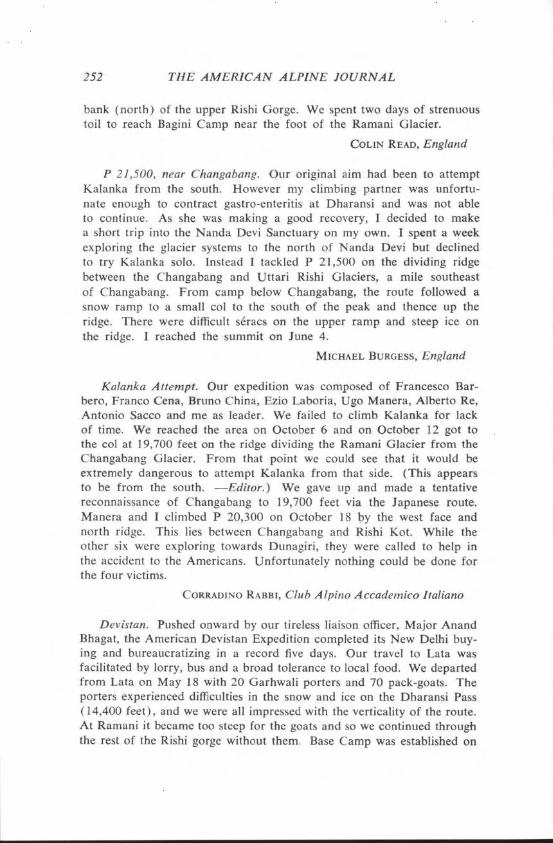
Changabang, West Well. Peter Boardman and I succeeded in climb- ing the west wall of Changabang up more or less a direct line to the summit. We went virtually directly to the summit from the snow shoul- der. Our route lay well to the left (north) of the Japanese route. It was

CLIMBS AND EXPEDITIONS 249
harder than anything either of us had ever done, comparable in technical difficulty to the American Direct Start to the west face of the Dru and the east face of the Grandes Jorasses. We had about 1700 feet of rope to leave on the difficult sections. Working from a tent on the snow shoulder, we spent six days climbing and fixing ropes up the increasingly difficult ground to the icefields in the middle of the face. Difficulties were of UIAA V or VI and direct aid. We had hoped to work from hammocks, but although the specially designed hammocks and sleeping bags worked well, we had to cook in the open and this took much too long. We lost too much body heat and energy. After three nights of this we decided to change tactics. We descended for a rest and then brought up a tiny tent, which we perched on a ledge chopped in the ice of the icefield. We took up the fixed rope from below and used it on the upper part of the face. Four days were spent in climbing and fixing rope for 1000 feet above the tent. Some days we did only two rope- lengths as the climbing was so hard. On the fifth day we took bivvy gear, jiimared to our high point, climbed and fixed rope for five rope- lengths up mixed ground to the foot of the summit slopes. We bivouacked there at 22,000 feet. The next day, October 15, we reached the summit at two P.M. We retreated down the route of ascent, stopping overnight at our tent on the icefield, at our tent on the col and at our Advanced Base on the glacier. We reached Base Camp on October 15. We were alone for forty days since our liaison officer went back to Delhi and we had no porters.
JOSEPH TASKER, Alpine Climbing Group
Changabang, Southeast Face. Our attempt on the south face of Changabang ended after 18 days. The rock was very compact and the strata often inverted, forcing us to use snow and ice wherever possible. Very difficult climbing was encountered before reaching the headwall at nearly 20,000 feet. At that point we decided that the climb could not be done in the remaining time and so we switched to our alternate route. Five members, Syd Clark, Dr. Jim Duff, Alan Roberts, Ted Rogers and I, made the first ascent of the southeast face, alpine-style. After three days of effort from Advanced Base Camp, we reached the summit on October 2. Some of the climbing on this ice face attained Grade 5 (Scottish). On the fourth day, we descended across the face of Kalanka to emerge below the extreme right edge of its southern flank, a new descent. Meanwhile our other two members, John Adams and Robin Blyth, climbed Sakram (20,520 feet), one of the peaks on the northern rim of the Sanctuary. They were later followed by Clark and Rogers. When the porters arrived to take us out, they said that they were unable to climb the treacherous fresh snow on the slopes of the upper Rishi Gorge. So we embarked on the first traverse of the complete true right

“a *
PLATE~O
Photo by Joseph Tasker
CHANGABANG’s West Wall.

252 THE AMERICAN ALPINE JOURNAL
bank (north) of the upper Rishi Gorge. We spent two days of strenuous toil to reach Bagini Camp near the foot of the Ramani Glacier.
COLIN READ, England
P 21,500, near Changabang. Our original aim had been to attempt Kalanka from the south. However my climbing partner was unfortu- nate enough to contract gastro-enteritis at Dharansi and was not able to continue. As she was making a good recovery, I decided to make a short trip into the Nanda Devi Sanctuary on my own. I spent a week exploring the glacier systems to the north of Nanda Devi but declined to try Kalanka solo. Instead I tackled P 21,500 on the dividing ridge between the Changabang and Uttari Rishi Glaciers, a mile southeast of Changabang. From camp below Changabang, the route followed a snow ramp to a small co1 to the south of the peak and thence up the ridge. There were difficult sCracs on the upper ramp and steep ice on the ridge. I reached the summit on June 4.
MICHAEL BURGESS, England
Kalanka Attempt. Our expedition was composed of Francesco Bar- bero, Franc0 Cena, Bruno China, Ezio Laboria, Ugo Manera, Albert0 Re, Antonio Sacco and me as leader. We failed to climb Kalanka for lack of time. We reached the area on October 6 and on October 12 got to the col at 19,700 feet on the ridge dividing the Ramani Glacier from the Changabang Glacier. From that point we could see that it would be extremely dangerous to attempt Kalanka from that side. (This appears to be from the south. -Editor.) We gave up and made a tentative reconnaissance of Changabang to 19,700 feet via the Japanese route. Manera and I climbed P 20,300 on October 18 by the west face and north ridge. This lies between Changabang and Rishi Kot. While the other six were exploring towards Dunagiri, they were called to help in the accident to the Americans. Unfortunately nothing could be done for the four victims.
CORRADINO RABBI, Club Alpino Accademico Italian0
Devistan. Pushed onward by our tireless liaison officer, Major Anand Bhagat, the American Devistan Expedition completed its New Delhi buy- ing and bureaucratizing in a record five days. Our travel to Lata was facilitated by lorry, bus and a broad tolerance to local food. We departed from Lata on May 18 with 20 Garhwali porters and 70 pack-goats. The porters experienced difficulties in the snow and ice on the Dharansi Pass (14,400 feet), and we were all impressed with the verticality of the route. At Ramani it became too steep for the goats and so we continued through the rest of the Rishi gorge without them. Base Camp was established on

CLIMBS AND EXPEDITIONS 253
May 25 just above Sarson Patal in the Nanda Devi Sanctuary. Four days later we occupied Camp I at 17,000 feet, and three days after that, Camp II 2000 feet higher. With the group dead-set against long, hard days, we established Camp III on a high plateau between Devistan I and II. On June 4 Chris Pizzo and I reached the summit of Devistan II (21,420 feet) from the east and continued a traverse, a good portion on front- points, down the southwest ridge. That same day Cheryl Arnold, Rocco Osbom and Mugsy Leitz gained the summit of Devistan I (21,910 feet) from the eastern face. On the following day, Toby Wheeler, Pizzo and I completed another ascent of Devistan I by the same route. With the exception of two retinal hemorrhages and Rocco’s spectacular crevasse plunge, the descent was made without incident. Our departure from the Garhwal proceeded with a short and scenic interruption, exploring the Trisul Nallah.
DAVID J. GRABER
Mrigthuni. Our expedition was composed of Waldemar Engel, Her- bert Voll, Albert Weber and me as leader. We got to Lata on September 18 and reached Base Camp at Tridang (15,750 feet) on the 24th. After acclimatization, Camp I was established on September 28 at 16,900 feet, Camp II on October 2 at 18,550 feet and Camp III on the 4th at 20,350 feet. Avalanche danger, crevasses and deep snow impeded us, but Sherpa Dawa and I were able on October 5 to reach the east ridge of Mrigthuni, which we followed over the eastern summit to the highest (western) point (22,490 feet).
HANS MECK, M.D., Deutscher Alpenverein
Maiktoli-Devtoli Traverse. Our expedition established Base Camp on September 22 at 15,000 feet in the Nanda Devi Sanctuary at the tongue of the Dakkhini Rishi Gal. Advanced Base Camp was placed up this glacier at 16,400 feet on September 24. The team separated into two groups to attempt the traverse from opposite directions. The Maiktoli- Devtoli group was made up of Toshio Imai, Tadashi Kanayama, Miyaki Iwanaga and Etsuo Noguchi. They placed Camps Ml and M2 at 18,375 feet (southwest and 250 feet above Sundardhunga Cal) and at 20,175 feet on Maiktoli’s northeast ridge on October 1 and 5. The actual traverse began when they occupied Camp Ml on October 8, M2 on the 9th and then moved this camp to 20,575 the next day. On the 11 th they climbed the knife-edge and bivouacked at 22,000 feet. On October 12 they climbed over the summit of Maiktoli (22,320 feet) and descended the northwest ridge to the co1 between Maiktoli and Devtoli, where they met the other group and bivouacked. On the 13th they skied directly down to D4 and descended to Advanced Base the next day. The Devtoli- Maiktoli group was composed of Tatsugi Iwata, Ryuji Sato, Koji Yanagida

254 THE AMERICAN ALPINE JOURNAL
and me. We meanwhile had placed Camps Dl, D2 and D3 at 18,375, 19,700 and 20,675 feet on the northeast face of Devtoli on September 29, October 1 and 6 respectively. From Camp D2 on October 9 Iwata and I climbed the 21,650-foot summit which lies just north of Devtoli by its 2000-foot-high northeast ice face and bivouacked on the top. We all moved into Camp D3 on October 10. On the night of the 11th we bivouacked between the previously climbed peak and Devtoli. On the 12th we moved up the north ridge to the summit of Devtoli (22,270 feet) and on to the bivouac between the peaks. Yanagida descended with the other group, but the rest of us continued over Maiktoli on the 13th and back to Advanced Base Camp the next day.
KAZUYOSHI KONDO, Japan Workers’ Alpine Federation
Dunagiri, North Ridge. Our team was composed of Norio Teramae, Minoru Umemoto, Noboru Takenaka, Naohiko Osugi, Takio Masuda, Takashi Sakai, Dr. Shioji Seki and me as leader. We set up Base Camp at 12,000 feet on the east side of the Gannakui Bank on September 21, following a four-day march from the village of Suraithota. The problem was where to get onto the north ridge. At first we started up an icefall, a short-cut route to a 20,100-foot peak on the north ridge, but after a two- day reconnaissance, we found we were running too much risk from falling ice blocks and returned to Base Camp. We reconsidered the route and selected one which led to a lower point on the north ridge through a big gully. The entire route was more difficult, longer, and yet less dangerous than the icefall route. Since there were difficult spots, for example steep ice walls, rock faces and several sharp gendarmes, we were forced to fix ropes, about 12,000 feet in all, and 100 feet of rope ladders. We set up five camps. It took us 30 days from Base Camp to the summit. All members except Dr. Seki and I were able to get there, three on October 21 and three more on October 24.
AKITAKE MAKINOUCHI, M.D., Japanese Alpine Club
Dunagiri Attempt and Tragedy. Nine Americans, one Mexican, and our Indian liaison officer, Mundip Singh, left Lata on September 25 and 26 with 46 porters. The goal was the third ascent of Dunagiri (23,184 feet). Base Camp at 15,200 feet was reached on September 29. Our planned route was the southwest ridge; the route of the Swiss first ascent (Roche, 1939) and of several other attempts. Two intermediate camps were established. Camp III in the col, at 19,400 feet, at the foot of the southwest ridge was established on October 9. Above here the difficulties begin. The snow was quite firm and the route is exposed so that some protection was required. On October 12 the high camp was moved to the foot of the rock step at 19,850 feet. By the 14th, six of us had had to

CLIMBS AND EXPEDITIONS 255
leave the mountain because our available time was growing short or for various other reasons. On October 15 Ruth Erb stayed at the 19,850-foot camp while the remaining four climbers, Graham Stephenson, leader, Arkel Erb, John Baruch, and Benjamin Casasola set out to establish a camp on the ridge above from which they hoped to reach the summit the next day. On the afternoon of the 16th, Ruth was watching Arkel and John descending the snow ridge between 21,000 and 22,000 feet when she saw them slip and fall. They fell about 3000 feet down the south side of the mountain. When Ruth went to where she could look onto the glacier below, she saw not only the bodies of her husband and John, but also those of Graham and Ben. Mrs. Erb spent the next two nights alone at her camp, hoping that the expedition’s porters at Base Camp would come up to see what was wrong and to help her down. She noticed some porters about 1000 feet below on the 17th. She whistled and thought they heard her, but was disappointed when they went back down. How- ever, the porters had gone down to Base Camp to get help. Italian climbers who had been climbing Kalanka were nearby and on the 18th, three of them and one porter helped her down. Two British climbers, Joe Tasker and Peter Boardman, who had just made the first ascent of the west face of Changabang, also had arrived. On October 19 they climbed up to the bodies and buried them on the glacier. We will never know just what happened, but it must have been an extremely treacherous, icy section. Other participants were: Robert Korns, M.D.; Tim Treaty, Neko Colevins, Bill Sanders and I.
DENNIS BURGE
Trisul. This 12-man Indian expedition was led by Lieutenant Colonel Narinder Kumar, Principal of the Indian Institute of Mountaineering and Skiing of Gulmarg. They left Joshimath on April 22 but were not at Base Camp until May 3, delayed by much snow. Jamadar Dil Bahadur, Havildars Gurcharan Singh and Dorji, Vijay Kaul, B.R. Sharma and Ghulam Mohiuddin Bhatt left Camp II (20,000 feet) at 4: 15 and reached the summit (23,360 feet) by the normal route at 9: 10 on May 17. They found a ski stick from which a Yugoslav flag was fluttering. While Dorji and Bhatt brought down the mountaineering equipment, the other four skied down, leaving the summit at IO:45 and reaching Base Camp at 11:55. On May 20 Major S.S. Singh, B.S. Bajwa, Havildars Dorji and Des Raj Sharma and Sherpa Nawang Tsering climbed to the summit and also skied down.
KAMAL K. GUHA, Himalayan Club
Trisuf. After establishing Base Camp at 16,000 feet in the Trisul Nallah on September 26, we placed Camp I at 19,350 feet and Camp II at 20,850 feet. On October 2 in wind and cold I guided Anton Klement,

256 THE AMERICAN ALPINE JOURNAL
Hans Kiippers, Dr. Jiirgen Polster, Dr. Werner Poster, Ernst Schiebler, Hans-Jiirg Stiller, Lothar Winter and my wife Gabi to the summit (23,360 feet). Schiebler had severely frozen feet and had to be evacuated by Indian Army helicopter. On October 6 I guided Klaus Giinther, Dieter Lindner, Gerhard Hohenleitner, Heiner Schmitt and our Indian Liaison Officer Asheesh Ambastha to the summit. We followed the normal route, which has no technical difficulties.
SIEGFRIED HUPFAUER, Deutscher Alpenverein
Trisul, West Face. The seventh Yugoslav expedition to the Himalaya came from Ljubljana and Medvode, having got the idea from the 1960 Yugoslav ascent of Trisul III and II. The face was observed from the upper skyline and judged to be from 8000 to 10,000 feet high. The group was made up of Tone Sazonov, leader, Zvone AndrejEir, Andrej Grasseli, Jo% HoEevar, Tone JegleE, Marko JureriE, Janez Kalan, &efan Marenre, Vanja Matijevec, Dr. Borut Pirc and Slavko Svegelj. After formalities were finished, they started from New Delhi on April 21 and went by bus to the village of Chat (4430 feet) in the Nandakini valley about 20 miles west of Trisul’s west face. From there the loads were carried by pack- animals to the village of Site], and thereafter by porters. The approach took seven days and ten loads did not arrive at Base Camp for a week more. Base Camp was established on April 29 at 14,750 feet below Nanda Ghunti. The next day three groups reconnoitered. Via an un- pleasant couloir, they found the way to the base of the face and there, on May 1, pitched Camp I on the upper Ronti Glacier at 17,000 feet. On the 2nd they reached the base of the central ice rib and pitched Camp II at 19,700 feet. Three porters helped the climbers carry to Camps I and II. Above Camp II they fixed ropes on water ice, mostly 55” with some vertical steps. On May 11 they reached the site for Camp III at 21,000 feet. Storms had caused much trouble; camps were damaged and even Base Camp was once destroyed. On the 13th three groups left Camp II. One climbed straight to Camp IV and pitched the camp; the second fixed ropes between III and IV; the third improved Camp III and returned to Camp II. After another stormy day, May 15 was ideal, cloudless and warm. The team hoped that the Indian Ski Expedition would come to the top the same day from the other side. Grasseli and MarenEe climbed the easy ridge to reach the top (23,360 feet) at nine A.M. The Indians found the Yugoslav ski pole with the flag two days later. On the same day Matijevec and Kalan reached Camp IV but Kalan decided to assist the first team to descend and so Matijevec went alone to the summit on May 16. This light-weight expedition took only 130 pounds of food from home.
FRANCI SAVENC, Planinska Zveza Slovenije, Yugoslavia

CLIMBS AND EXPEDITIONS 257
Bethartoli South. Our small, low-key party consisted of Kevin Westrin, Dr. John Atkinson, Peter Marsh, Liaison Officer Captain Raju Chatuverdi and me. It took a long time to acclimatize and when we eventually had our high camp stocked, we sat out a week of bad weather and managed to climb only Bethartoli South (20,730 feet).
ROBERT RYAN, Australia
Abi Gamin. The Indo-Japanese Women’s Expedition II, sponsored by the Japanese Alpine Club and the Indian Mountaineering Founda- tion, had hoped to climb both Kamet (25,447 feet) and Abi Gamin (24,130 feet). The first ascent of Abi Gamin by women was made on June 18 but we were unsuccessful in two attempts on Kamet due to bad weather. Our Indian members were Dr. Meena Agrawal, leader, Chandra P. Aitwal, Thrity F. Birdy, Rama S. Gupta and Bharati Baner- jee. Our Japanese members were Fumie Nasu, Harumi Shimizu, Nobuko Takamoto, Yukiko Tomita and I as deputy leader. We took the same route as that of the Smythe party of 193 1 and of the N. Jayal party of 1955. After leaving New Delhi on May 10, we got to Base Camp at 15,100 feet near the confluence of the Purbi Kamet and the Raikana Glaciers on the 19th. We established camps as follows: I ( 15,900 feet) on May 23; II ( 16,750 feet) on May 26; III (Advanced Base) (17,900 feet) on May 29; IV (20,000 feet) on June 5; V (22,300 feet) on June 12; and VI (23,450 feet) on June 15. We made two unsuccessful attempts on Kamet on June 16 and 17. On the 18th Chandra Prabha Aitwal, Thrity Birdy and Fumie Nasu with Sherpas Lakpa Tsering and Kami Tsering reached the summit of Abi Gamin.
MICHIKO SUDA, Japanese Alpine Club
Chaukharnba I or Badrinath Peak, Pranesh Chowdhury, Bidhan Banerjee, Jalad Banerjee and Sherpas Lhakpa Tsering, Mingma and Nuri climbed this peak (23,420 feet) on October 6. They left Asansol on September 19 and set up Base Camp at 14,200 feet on the 25th. Advanced Base at 17,000 feet was placed on the left bank of Bhagirath Kharak two days later. Camp I was occupied at 19,000 feet on Sep- tember 30. That day the climbers stumbled on the remains of the Swiss expedition of 1939 at 18,000 feet beside a glacier table on the Bhagirathi Glacier. They found broken ice axes, crampons, climbing boots, gloves, a water bottle marked “A. Roth” and other equipment. They also found human remains. On September 10, 1939 an avalanche had hit the Swiss Camp I. AndrC Roth, Fritz Steuri, David Zogg and Sherpas Nuri and Tillye had been swept down some 1650 feet but escaped death. The body of Ajitia could not be found and Gombu died that same night. The equipment was strewn and given up as lost.

258 THE AMERICAN ALPINE JOURNAL
This year Camp II was set up above an icefall at 20,000 feet on October 3 and Camp III at 21,500 feet on October 5. The climbers left for the summit at 8:15 and got there at 5:45. As it is a sacred peak, they did not set foot on the summit but placed floral wreaths and a metal plate with the names of the expedition members on the summit.
KAMAL K. GUHA, Himalayan Club
Jogin III. Captain Jai Bahuguna, leader, and Captain Hem Lohumi climbed Jogin III (20,065 feet) on May 5. Other members were Major M.S. Negi and Captains Vijay Bhatt and N.S. Garewal. Garewal and Bhatt made an unsuccessful attempt on Jogin I (21,210 feet) on May 2 from Camp I at 17,400 feet, but were turned back by deep snow and bad weather. Camp II was set up at 19,000 feet to reduce the dis- tance. On May 25 Bahuguna, Lohumi and a porter left Camp II for Jogin I. The weather was bright and sunny but the snow was deep. The porter gave up after 45 minutes. Progress was slow and they got to the co1 between Jogin I and III only at 12:30. From there the ice was hard and the wind strong. Still 650 feet below the summit of Jogin I, they were enveloped by dark clouds and so they gave up and returned to the co1 to climb Jogin III.
KAMAL K. GUHA, Himalayan Club
Gangotri I and Rudugaira. Gangotri I (21,980 feet) was climbed from the Gangotri I-Rudugaira co1 via the northeast ridge on June 10 by Sherpa Chewang Thondup, H.M. Antia, V.S. Mahajan and Ranveer Singh. Students from the Doon School in June and students from the University of Roorkee in July climbed Rudugaira (19,090 feet).
KAMAL K. GUHA, Himalayan Club
India-Himachal Pradesh
Dharam Sura or White Sail. Horoyasu Takemato, leader of a Japanese expedition, was killed as he fell on September 6 at 20,130 feet on this 21,148-foot peak. Sherpa Phurba Dorji, who was with him, was injured and has since recovered. The expedition was abandoned.
KAMAL K. GUHA, Himalayan Club
Fluted Peak, Spiti. Dilip Bhattacharjee, Samir Banerjee, Rajani Rakshit and two high-altitude porters, Tsering and Tenzing, climbed Fluted Peak (20,200 feet) on August 27. The nine-member team was from the Climbers’ Group, West Bengal. They climbed the east ridge. The mountain had been previously climbed by a British team in 1958.
KAMAL K. GUHA, Himalayan Club

CLIMBS AND EXPEDITIONS 259
Mulkila 5 Attempt. An expedition to the Kao Rong peaks was or- ganized by Lute Jerstad and led by Del Young. Aside from Young, we were Bart Cary, John McIlvenna, Joe Wagner, Brad Bennett, German Ms. Lore Zahn, Canadian Earl Kowall and I. We left Manali on May 26 and went through Keylang to Darcha, where we arrived on June 1. Our planned approach to the Kao Rong peaks through the village of Sarai was negated by the Indian Government, being too close to the Indo-Tibetan inner defense line. We therefore left Darcha and went south up the Milang Nala. A reconnaissance up the Kao Rong river from the west revealed a wedge-shaped gorge with a narrow base several miles long and hazardous with rockfall. The Mulkila peaks just south were accessible and we decided to direct our efforts to the north face of unclimbed Mulkila 5, c. 21,100 feet. From Darcha at 11,000 feet, Base Camp was established at 16,000 feet on June 5. Once at Base, the weather began to create problems. Camp I at 18,000 feet was occupied on June 9 at the foot of the M-4 and M-S north faces. Several ropes were fixed to Camp II at the base of the bergschrund at 19,500 feet on the north face of M-5. The saddle between the two peaks, some 700 feet higher up 45O ice, lies at the foot of the summit ridge. The wind increased. At 9:30 P.M. on June 11 avalanche spindrift partially covered the tent occupied by Del, Brad and me. John and high-altitude porter Tashi were buried. We were fortunate in being able to dig them out within five or ten minutes without injury. We spent a frightful night in the remaining tent. Because of continuing storms we left the mountain.
WILLIAM B. SEALE, Unaffiliated
Mulkila (M4). Our party, consisting of Tsukasa Oshi, leader, Kenzo Tamura, Shinichi Nojima and me, left from the last village in Lahoul on August 23 and reached Base Camp at 15,100 feet on the Mulkila Glacier on August 26. We prepared for climbing and acclimatized for a week. Camp I was set up on September 3 at 16,750 feet. Camp II was set up at 18,375 feet on September 6. The area between Base Camp and Camp II was full of crevasses. Since there was no suitable place for a higher camp, we spent from September 8 to 13 preparing the route. We fixed 1300 feet of rope to climb the ice face, in places 70”. Our attempt on September 14 failed for lack of time. Again on Sep- tember 16 all four set out at 6:30 A.M. in fine weather. After climbing the fixed ropes, we started up the ridge leading to a difficult chimney, where we needed another 125 feet of fixed rope. The entire ridge from the chimney to the top (21,380 feet) was snow and rock. We reached the top at 4:35 P.M. and got back to Camp II at midnight.
JUNICHI MUKAI, Ryohou Club, Japan

260 THE AMERICAN ALPINE JOURNAL
Correction on M-6. The name of Tom Ettinger was unfortunately omitted from the Personnel on page 369 of A.A.J., 1976 as one of those who was on the climb of the northeast ridge of M-6.
Sher Khan, Sundar Pahar, Taragiri, Kishtwar Himal. In June Peter Aldrec, John Batson, Hamish Emmerson, Ray Sharples and I reached Kishtwar village in our Ford van. Peak fees had been paid and an import license for our equipment obtained in New Delhi and we were now joined by our Indian Army liaison Officer, Captain Daniel Whit- church, who was to stay with us for our seven-day stay. He was a helpful guide and interpreter. The local bus was taken to the end of the road at Galhar, and here 11 mules were hired to take our 500 kgs of food and equipment up the track following the Chenab River to Athole. We then went up a tributary to the last village, Machail. From there 15 porters took the gear to Base Camp, four days and 50 miles from Galhar! Base Camp was on a grassy area below the Donali Glacier, also the base for friendly, hospitable shepherds who guarded camp while we were in the mountains. The first advance camp was placed on the Bhazun Glacier, from where we made attempts on Sher Khan (19,324 feet). Although the weather was excellent, soft snow de- feated the early attempts. In the final phase, Sharples and Emmerson returned to the Bhazun camp to complete, on July 12 to 16, the ascent of Sher Khan. They crossed a 17,000-foot co1 to a high snow bowl and climbed a steep couloir on the south face that led to the east ridge. Taragiri (c. 17,700 feet) was climbed on June 29 with our liaison officer. The route followed the east ridges and easy rock to a dangerous cornice, which we climbed in atrocious conditions. This peak lies halfway between Sickle Moon and Sher Khan. Batson and I traversed Sundar Pahar (18,330 feet) from June 6 to 8. We followed the long east ridge, skirting gendarmes by means of steep gullies, and climbed the south face before we descended from the summit down the west face to a snow col. A party attempted the east ridge of Arjuna (20,440 feet) but was turned back after four days by bad weather.
JOHN CANT, University of St. Andrews, Scotland
Attempt on Katori, Kishtwar Himal. Ronnie Richards, liaison of- ficer Captain Nair and I left Kishtwar on August 16 and took two days to reach Sondar villege. We employed six porters and reached the edge of the Kibar Glacier on August 20. The next two days were spent ferrying loads up the icefall of the Kibar Glacier to the upper glacier below Tramkhan (6001 meters or 19,688 feet) and Katori (6138 meters or 20,142 feet). On August 22 Richards and I moved up to camp below the two peaks. The weather was unusually unsettled with mild nights and snow every afternoon, much worse than we had

CLIMBS AND EXPEDITIONS 261
experienced at the same time of year in 1973 on Brammah. We had to wait for a hard freeze. We set out at five minutes after midnight on August 27. Carrying four days of food, we intended to make an alpine-style ascent of the north face of Katori. We reached the berg- schrund at two A.M. and then climbed by early morning 1500 feet of steep snow lying on ice to where the face began to steepen. After being delayed by difficult terrain-thin ice over smooth rock slabs- at 3:30 P.M. we stopped at 18,375 feet on the crest of a small artte since the snow was soft and dangerous. After a bivouac, in view of very bad snow conditions on the upper face and the unsettled nature of the weather, we retreated. Insufficient time and unsettled weather sent us back to Kishtwar.
CHRISTIAN BONINGTON
Cathedral Attempt, Kishtwar Hirnal. The Loughborough University Mountaineering Club expedition was composed of Steven Ripley, Glyn Lloyd, Stephen Lonsdale, Stephen Pallington, Robert Elder, Jonathan Youngman and me as leader. We arrived in Kishtwar, the nearest town, on August 22 and set out on the 65-mile march to Base Camp at 12,200 feet at Wakbal in the Kiar Nai valley. Porters and mules were used for the journey, and for the last five miles we had to hire mountain ponies from nomadic shepherds to cross three glacier rivers. The trip should have taken five days, but porter troubles prevented our getting to Base before September 7. The weather was bad, cold, raining and snowing but after a couple of days it cleared sufficiently for recon- naissance. The main summit of Cathedral is flanked on the southwest and south by numerous pinnacles like Gothic spires. Both the spires and the west face of the Cathedral would have called for extremely difficult rock climbing. To the north of the main summit, separated by a glacier, is a large rock pinnacle. The glacier had ice cliffs which were constantly avalanching and so we finally worked out a route up the north pinnacle to reach the glacier above the ice cliffs. On September 11 Ripley, Lloyd, Lonsdale and I set off on a summit attempt up a gully in the west face of the north pinnacle. We continued up into the co1 of a rock tooth where we set up Camp I, 200 feet above the glacier. A small avalanche swept off Ripley and Lloyd and they were slightly injured. We spent a cramped night at 16,050 feet in the co1 between the north pinnacle and the main summit. Bad weather pre- vented further advance. On the 14th Lonsdale, Elder, Youngman and Pallington set out for a second attempt. On the 16th they tried for the 17,600-foot summit. Snow conditions were bad and the route was blocked by verglas-covered slabs. After 14 hours of climbing there was still 500 feet to go and all descended to Camp II. Elder and Lonsdale waited out another two-day storm but had to return to Base on September 18.
ANDRZEJ JUDKOWSKI, Loughborough University, England

262 THE AMERICAN ALPINE JOURNAL
P 19,470. This peak, southeast of Gangtang in Kinnaur, was climbed on May 15 by a nine-man team from the Himachal Police, led by L.C. Kaushash. It included 13-year-old Deepak Sahrma. The highest of their four camps was at 15,225 feet.
KAMAL K. GUHA. Himalayan Club
Barnaj II Attempt and Ascent of P 5130, Kishtwar Himal. Masami Uematsu, Toshiharu Hashimoto, Tadashi Ito and I attempted Barnaj II (20,637 feet) up its west side but were turned back by bad weather at 16,100 feet. On October 13 Uematsu and Hashimoto climbed P 5130 (16,83 1 feet) from the east. This lies on the divide between the Barnaj and Bhazum Nallahs. We approached by going north from Machail village to Base Camp at 13,000 feet. There are a number of unnamed peaks about 20,350 feet in the Machail part of the Kishtwar Himal.
MASAKI KANEKA, Japanese Alpine Instrument Technique Club
Null. Two expeditions were on Nun (23,410 feet) in October. The Swiss skier, Sylvain Saudan, had hoped to ski from the summit. They set up Camp II at 19,700 feet on October 5 but could not reach the summit because of high winds, snows and blizzard for the next three days. Saudan and his team returned to Srinager on October 12. They had attempted the conventional western route. Meanwhile a Czech team had set up Camp I at 17,400 feet, hoping to ascend the unclimbed northwest ridge. Finally on October 27, the leader Frantisek Cejka and Josef Vancuta reached the summit, followed the next day by five more members of the expedition.
KAMAL K. GUHA, Himalayan Club
Kashmir-Jammo
P 65.50 and P 6560, Doda River Valley. The Toyo University Himalayan Expedition climbed the peaks at the head of the Doda River valley. We arranged at Pannikar for 25 ponies to take us to Base Camp, at 13,875 feet, where we arrived on September 5. Camps were estab- lished as follows: Camp I at 15,600 feet on September 7; II at 17,050 feet on the 12th; III at 18,375 feet on the 16th. On September 17 Hitoshi Furuya and Kimamasa Miwa climbed the north ridge to the summit of P 6550 (21,490 feet), the western summit of this two-sum- mited peak. On the 19th Kaoru Nagaoka, Kikuichi Sugiyama, Akira Suzuki and Matsuo Ominato climbed the northwest face to P 6550, despite crevasses, and on the 20th leader Kenshiro Otaki, Yuzo Torii, Kenji Hasegawa, Takehiko Shibao, Akio Hayakawa and I followed the

CLIMBS AND EXPEDITIONS 263
same route to the top of the western and eastern (P 6560; 21,523 feet) summits. We employed no porters.
AKIRA KOBAYASHI, Toyo University Alpine Club, Japan
Kang Lacha. An expedition from Southampton University climbed six peaks in Ladakh this summer. The highest was Kang Lacha or Stok Kangri (20,723 feet) by its east face. The other peaks were over 19,000 feet. The team consisted of Mark Dravers, Mike Ritchie and me, plus a Canadian Terry Rollerson. We also tried an unnamed peak of 21,000 feet, 40 miles south of Leh but failed.
SIMON FRASER, England
Pakistan
K2, Northeast Ridge Attempt. The Polish team was led by Janusz Kurczab and composed of Eugeniusz Chrobak, Leszek Cichy, Andrzej Czok, Ryszard Dmoch, Janusz Fereliski, Kazimierz G,Yazek, Marek Grochowski, Z. Andrzej Heinrich, Jan Holnicki-Szulc, Piotr Jasinski, Piotr Kintopf, Dr. Jan Koisar, Marek Kowalczyk, Wojciech Kurtyka, Andrzej xapiriski, Tadeusz Xaukajtys, Janusz Onyszkiewicz and Wo- jciech Wr6z. The approach march was made in two groups with 300 porters and took 13 days to reach Base Camp on June 24 at 16,400 feet on the Godwin Austen Glacier. They did not use any high-altitude porters. Camp I was established on the upper Godwin Austen Glacier at 18,375 feet on June 25, Camp II on a side ridge to the main one at 20,000 feet on July 3, Camp III on the ridge at 22,150 feet on July 7 and Camp IV also on the ridge at 22,800 feet on July 17. There were enormous technical difficulties between Camps III and IV. Usually the monsoon does not affect the Karakoram, but in 1976 Pakistan had the worst in 100 years. After Camp IV was established the weather rapidly deteriorated. Twice attempts were made to establish Camp V but severe winds turned them back at 24,000 feet. Avalanches swept the route. On August 5 the weather improved and since they were behind schedule, they decided to establish Camps V and VI in one go and make two tries for the summit. All members were to carry to Camp V. The plan went slowly. The tents at Camps III and IV were collapsed under six feet of new snow. On August 12 Camp V was established at 25,250 feet on a snow dome at the bottom of the summit pyramid. On the following day Camp VI was placed at 26,250 feet at the beginning of the steep, final slope. On August 14 Cichy and Holnicki forced their way up an ice barrier at 26,575 feet and then to a 200-foot band of sCracs and vertical rock. That same day Chrobak and Wr6z slept at Camp VI and set out early on August 15. They used no oxygen up to the first band. It took them most of the day to climb


CLIMBS AND EXPEDITIONS 265
the band, where the difficulties were up to UIAA V. Above the band they climbed the steep snow slope and at six P.M. had to stop, being out of oxygen, at 27,550 feet. The weather became worse. Because of the steep route and difficult conditions they had to rappel most of the way down. They got back to Camp VI at three A.M. All with- drew to Base Camp by August 19. Bad weather continued until August 28 when parties moved upwards again. Two days later conditions were much worse as the climbers were in Camps I, II and III. On Sep- tember 2 they started their final retreat. The pyramid of K2 remained unclimbed but all the difficult parts had been done; the remaining 700 feet would have been on a slope of decreasing steepness.
MAREK BRNIAK, Klub Wysokogdrski (Polish Mountaineering Club)
K2 Reconnaissance. Three climbers of our K2 reconnaissance party, which numbered six, reached 23,500 feet on the Abruzzi Ridge on August 7. Base Camp was established at 16,000 feet on July 11, Camp I at 17,000 feet on July 15, Camp II at 20,000 feet on July 17 and Camp III at 22,000 feet on July 28. The weather was fine for eleven straight days but deteriorated on July 28.
ICHIRO YOSHIZAWA, A.A.C. and Japanese Alpine Club
The Height of K2. A number of authorities on the Karakoram have cast doubts on the altitude of 28,741 feet or 8760 meters given by the Survey of Pakistan as the new altitude for K2. For instance, Trevor Braham, former editor of the Himalayan Journal, wonders if there is any evidence of a new survey. Anders Bolinder has expressed his reservations in print. The point has been raised that if the height of K2 is to be so much higher, would that not also have to raise the altitudes of most of the other peaks of the Karakoram? The leader of the recent Polish expedition to K2, Janusz Kurczab, states, “Assuming the altitude of K2 is 8611 meters (28,250 feet), we believe that the heights of neighboring summits as they appear on the map are correct.” In other words, if the height of K2 is higher than previously thought, all the altitudes in the region would also have to be corrected. Until the whole of the Karakoram is resurveyed or new evidence is given of the accuracy of the new figure, it may be safer to stay with the old.
Skyang Kangri Attempt, 1975. One of the world’s high unclimbed mountains, Skyang Kangri (24,750 feet), a close neighbor of K2, was unsuccessfully attempted by a very young group of eight Austrians, half of them teen-agers, half female. On September 13, 1975 Valentin Caspaar and the leader Ferdinand Deutschmann were climbing at about 23,000 feet above Camp III. Caspaar found himself too exhausted to

266 THE AMERICAN ALPINE JOURNAL
continue but urged his companion to go on. He was never seen again. Caspaar waited in Camp III until the 15th. As he descended alone to Camp II, he started a windslab avalanche which carried him down 1500 feet. Luckily he was not buried. On September 18 Mischa Andrik lowered him to Windy Gap and then hurried down the Baltoro Glacier to summon a helicopter. Sigi Gumpel escorted Caspaar to Base Camp from which he was airlifted on September 30.
Skyang Kangri. The expedition of the Alpine Club of Gakushuin University made the first ascent of Skyang Kangri (24,750 feet) on August Il. We left Rawalpindi for Skardu on June 25 with four tons of supplies and followed the Baltoro and Godwin Austen Glaciers to the traditional K2 Base Camp at 16,400 feet. Camp I was at 18,375 feet on the upper Godwin Austen Glacier, 5% miles from Base Camp. We attacked the east ridge from there. The ridge rose like a five-stepped stair to the summit. On July 18 we placed Camp II (20,350 feet) under a huge rock we called “Cat’s Ear,” a part of the first step. Above Camp II we found a tent and rope, probably from the unlucky Austrian expedition of 1975. The lower part of the second step had a big cre- vasse, from which the Duke of the Abruzzi must have withdrawn in 1909. Fortunately we could cross the crevasse rather easily thanks to an ice bridge. Between the second and third steps the route ran through the sCracs of a hanging glacier, which fell to the head of the Godwin Austen Glacier. On July 25 Camp III (21,650 feet) was set up on the second step. After a period of bad weather, we climbed the ice walls of the third and fourth steps and on August 8 placed Camp IV on the latter at 23,300 feet. On August 9 Hideo Nishigori and Yoshio Kinugawa tried to approach the summit but had to turn back because of heavy fatigue. They returned from 23,625 feet, but they had found the route. On the 1 lth Yoshioki Fujioji and Hideki Nagata made a second chal- lenge via the same northeast route to 23,625 feet and successfully reached the ridge top. When they dug a tunnel through hanging cornices, their eyes caught a close view of the summit. The true summit is just a little higher than the southwest peak, which had previously been accepted as the very summit, but there is no doubt that they climbed the highest. They reached the top at one P.M. and took a 360’ panorama. Other members of the party were Munetsugu Nieda, Kazuya Takahashi, Ya- suharu Daiguji, Yoji Iijuka, Yukihiro Fukazawa and I as leader.
GENZO MITSUI, Gakushuin University Alpine Club, Japan
Trango Tower. The Trango Tower, attempted in 1975, was climbed this. year. The team was Martin Boysen, Joe Brown, Malcolm Howells and I, accompanied by two film makers, Tony Riley and Jim Curran. All four members reached the summit: Boysen and I on July 8 and


268 THE AMERICAN ALPINE JOURNAL
Brown and Howells on July 9; Riley got to within 400 feet. The route was the same as last year. From Base Camp we climbed a gully south of the tower to place a camp on the shoulder. From the previous high point, we established a bivouac at 19,500 feet. It took three days of technically very difficult climbing from the bivvy to the summit. All members shared leads, but Boysen did the lion’s share. The top pitch proved to be the most difficult; Boysen took two falls! The descent was made in bad conditions with the face literally falling to bits. We abandoned virtually all equipment for safety. The height of the south- west face is 500 feet, which we did in 35 pitches. There was mixed climbing for the first third and continuous, difficult rock for the re- mainder. It went 80% free and the rest artificial.
MO ANTHOINE, Alpine Climbing Group
Broad Peak Attempt. Our expedition hoped to climb both the main and the central summits of Broad Peak alpine-style. The rope of three, Bernard Mellet, J. Claude Mosca and I, were supported by Dr. Daniel Mennesson. We followed the Austrian first-ascent route and made four attempts: May 30 to June 2 to 21,000 feet, June 6 to 10 to 23,000 feet, June 12 to 17 to 20,500 feet and June 25 to 30 to 26,000 feet. The last attempt reached the co1 below the two summits. The reason for our lack of success was very bad weather. From June 3 to July 3 there were only eight days when it did not snow.
YANNICK SEIGNEUR, Groupe de Haute Mantagne
Hidden Peak Attempt. Our very light expedition consisting of Marc Batard and me left France with 265 pounds of baggage and bought 330 pounds of food in Rawalpindi for ourselves and for our liaison officer. We traveled by jeep on May 24 from Skardu to Dasso. Our approach took 12 days with a day’s rest at rDokas. We had 17 porters at the start and 11 at the end of the approach. We got to Base Camp on June 6 at 16,900 feet, where our 1975 Base had been. On June 7 and 8 we carried to 20,000 feet, hoping to climb a kind of spur of sCracs over Hidden Peak South (23,190 feet), and on June 9 made a dump of as- sault and bivouac equipment at 21,325 feet. From June 10 to 14 it snowed without stopping. We climbed to almost 23,000 feet on June 14, but had another severe snowfall on the 15th. Nearly continuous bad weather until the 24th persuaded us to retreat and on June 25 we reached rDokas, fearful of not getting back for our charter flight. On June 28, feeling the weather was improving, we started back and got to Base Camp the next day. On June 30 we climbed back to 21,325 feet but found our dump swept by avalanches. We gave up and descended very rapidly to Skardu. The monsoon normally does not affect this region but did this year. We had hoped to traverse Hidden

CLIMBS AND EXPEDITIONS 269
Peak South and East (24,620 feet) to reach the main peak. This was the route attemped in 1936 by Henri de Segogne’s French expedition.
LOUIS AUDOUBERT, Groupe de Haute Montagne
Masherbrurn Attempt. A 14-man Japanese expedition led by Hirokazu Miyashita attempted Masherbrum from Base Camp on the Mandu Glacier (Mundung Gang). Camp I was established on the west ridge at 16,000 feet but the route leading to it was destroyed by an avalanche on July 8. They then turned to the north ridge but ran out of time and gear at 18,200 feet.
Baltoro Kangri. A nine-man Japanese expedition led by Tomoya Akiyama followed the 1936 first ascent route on Baltoro Kangri (23,990 feet), previously known as Golden Throne. On July 7 from Camp IV at 22,650 feet Y. Toyama and G. Sueki got to the summit after traversing Baltoro Kangri II and III. They were met on the top of Baltoro Kangri III by their support party.
Gasherbrurn II Tragedy. A Japanese expedition of 13 members ap- proached Gasherbrum II from the South Gasherbrum Glacier. Camp I at 17,000 feet was established on May 21 and Camp II at 19,000 feet on May 26. The next day Taketoshi Miyamoto and Yoshinori Hiramatsu were killed in a crevasse accident and on June 1 Osamu Mastuura died from fatigue and effects of high altitude after his rescue activity. The expedition was then abandoned.
Mustagh Tower Attempt. A 14-man Japanese expedition led by Ryuji Ichihashi attempted the difficult southwest face of the Mustagh Tower (23,860 feet). They placed Camp III at 21,825 feet, from which they got to a high point of 23,000 feet on June 18.
Saltoro Kangri II Attempt. Double-peaked Saltoro Kangri (25,400 and 25,275 feet) lies in the southeastern Karakoram. It was attempted in 1935 by Waller and Hunt, who failed because of bad weather and supply difficulties. On July 24, 1962 Japanese Saito and Takamura, and Pakistani Bashir reached the summit of Saltoro Kangri I. Japanese in 1975 failed to climb Saltoro Kangri II because of supply problems and avalanche danger. Our Hamburg expedition was composed of Heiko Irmisch, Bernd Briigge, Friedrich Clauss, Claus Dittmers, Martin Roeder, Bernd Schaarschmidt and me as leader. We traveled from Skardu to Khapalu by jeep on April 28. We were horrified to find the official rate for porters had gone up to 60 rupees per day, but were assured of no

270 THE AMERICAN ALPINE JOURNAL
strikes. However our porter problems began on the second day when the porters refused to do more than a four-mile stage. On the fifth day we got to Goma at 11,000 feet at the entrance to the Bilafond valley. We entered this narrow valley and on the second day started up the endless moraine of the glacier. After two days on the glacier, at Naram (14,600 feet) half the porters struck and were paid off. Only 46 wanted to go one stage further to our preliminary Base Camp at Ali Brangsa (16,075 feet), but after a storm even this number dwindled to 15. From Ali Brangsa we had planned to go over the Bilafond La to the Lolofond glacier and then to the Peak 36 Glacier, a 20-mile semicircle, but Dittmers and I reconnoitered a more difficult but shorter approach from the Bilafond La straight across to the upper Peak 36 Glacier. On the second evening we got to the top of the Bilafond La ( 18,200 feet). From there we climbed northwest to a 19,350-foot pass. From the top of the pass a 50’ to 55” slope fell 1000 feet to the Peak 36 Glacier. We had a marvelous view of our proposed route. We would cross the glacier for 1% miles to Camp III at 18,700 feet. From there to Camp IV at 20,175 feet would be technically the most difficult. The way to Camp V at 21,325 feet seemed objectively dangerous from avalanches, as later proved the case. Another of our many porter strikes took place 350 feet below the Bilafond La. We did manage to get the supplies to the glacier in a week. Irmisch and I reconnoitered the route on May 31 and June 1 up the east spur and finally found a complicated way to Camp IV. The weather remained unsettled and often stormy. Avalanches came very close. Dittmers and Roeder reconnoitered to 21,325 feet, apparently beyond technical difficulties. We decided not to risk carrying loads beyond Camp IV but to make a summit attack from there. On June 9 avalanches streamed over the route. Three days later we again packed our rucksacks for the summit but it snowed all night and we realized we must give up.
G~JNTER SCHULZ, Deutscher Alpenverein
Singhi Kangri. The Tohoku University Expedition left Khapalu on June 9 with 137 porters. Base Camp was established on the left side of the Siachen Glacier at 17,000 feet on July 10; we used 20 high-altitude porters over the Bilafond La and Lolofond Glacier. Ten members estab- lished Camp I on July 18 at 19,200 feet below the wall of the Siachen Mustagh. Camp II at 19,000 feet on the Staghar Glacier was established as Advanced Base on July 23. Camps III and IV were set up on the northwest ridge of Singhi Kangri at 20,675 and 21,750 feet on July 26 and 28 respectively. On August 8 Shohei Takahashi, Junichi Imai and Masafumi Katayama reached the summit (23,628 feet). On August 9, Climbing Leader Tetsuo Kakatsu, Masataka Shiobara, Kazunori Ohira and Nobuyuki Furuya stood on the top. The other members of the party

CLIMBS AND EXPEDITIONS 271
were Dr. Yasuo Akiyama, Yoshinori Shinohara, Masaaki Tomomizu, Yasutaka Kanamori and I as leader.
HARUO SATO, Tohoku University, Japan
Apsarasas. We of the Karakoram Expedition of the Osaka University Mountaineering Club made the first ascent of Apsarasas (23,770 feet) on August 7. The members were Kanji Kurihara, Toshio Ishihara, Yoshio Inagaki, Tetsuru Miki, Katsuhisa Yabuta, Takamasa Miyomoto, Shinzo Yoshida and I as leader. On May 24 the long approach march started from Khapalu, and went through the Bilafond Glacier, Bilafond La, and the Lolofond, Siachen and Teram Shehr Glaciers. We established Base Camp at 17,060 feet on June 26 and Camp I at 18,700 feet on July 3. When, on July 8, all supplies were at Camp I, the porters returned to their villages. We began the long climb towards the west ridge, which is a narrow snow ridge in the lower part and a steep ice wall in the upper part. Camp II (20,350 feet) was established in a crevasse in the hanging glacier on July 20. We fixed 1650 feet of rope between Camps I and II. Camp III was placed at 22,000 feet at the foot of the south peak on July 26. After reaching the south peak (23,350 feet), bad weather prevented activity. Yet all eight climbers remained at Camps II or III. On August 4, we placed Camp IV at 23,000 feet, beyond the south peak, and four stayed on, waiting for good weather. On the long-awaited fine day on August 7, Inagaki, Yabuta and Miyamoto got to the top at nine A.M.
HIDEO MISAWA, Osaka University Mountaineering Club, Japan
Sherpi Kangri. The Kobe University Karakoram Expedition con- sisted of T. Tanaka, M. Tsurutani, N. Okamoto, M. Nakamura, T. Inoue, S. Ogata, K. Kimoto, C. Itani, K. Hiroishi, Liaison Officer Captain Asad Ullah Jan Mir and me. We started from Khapalu with 138 low-altitude and six high-altitude porters on June 16 and arrived at the foot of the first icefall of the Sherpi Gang (glacier) on the 24th. The transportation of loads to Base Camp at 15,900 feet on the upper side moraine of the third icefall was finished on July 6. Two possible routes were considered: the east and west ridges. We selected the latter, as had been suggested by the 1974 reconnaissance. Advanced Base was set at 17,225 feet and Camp I at 19,200 feet just below the west ridge. It took great effort to climb the ice wall up to Camp II, being in places vertical. Camp II was pitched at 20,850 feet on the ridge. The ridge was sharp and steep, both ice and rock. We then crossed the “Eagle Head,” one of the hardest parts of the route and pitched Camp III at 22,300 feet. At 4:15 A.M. on August 10 Inoue and Ogata left Camp III and reached the summit (24,212 feet) at 9: 15. The weather was perfect and they could see all of the Karakoram.
KAZUMASA HIRAI, Japanese Alpine Club
272 THE AMERICAN ALPINE JOURNAL
K7 Attempt. We first set up our Base Camp on the Kaberi Glacier, east of K7. There was no route there as the peak was guarded by a steep, 5000 to 7000-foot rock wall. The north face was the same as the east side. Finally we went around to the Charakusa Glacier, west of K7 and found a small glacier going to the col on K7. We tried it and reached 18,700 feet. It was too late an,d too far from our Kaberi Base Camp. In our party were Kaoru Takao, Masayoshi Nakahori, Youichi Yama- moto, Toyofumi Miyazaki, Seiya Ryu and I as leader.
YOSUKE NARISUE, Fukuoka Climbing Club, Japan
Gharkun Attempt. A Japanese expedition of the Iida Mountain Club, led by Haruki Sugiyama, tried to make the first ascent of Gharkun, which lies just south of K21 in the southeastern Karakoram. Having ascended the Dansam River, they placed their Base Camp at 14,275 feet on the Gyong Glacier. Three more camps were placed on that glacier, at 15,600, 17,000 and 18,000 feet. They then climbed a 2500-foot rock face with 4000 feet of fixed rope. Three members had to leave. Two of the remaining five made a summit attempt on July 28 and 29 with a bivouac. They reached a summit but found they were on the lower south peak (21,325 feet). The other three then also climbed the south peak on July 30, but they too failed to get to the higher north peak (21,720 feet).
Latok I Attempt. Our expedition attempted to climb Latok I (23,442 feet, which is north of the Baintha Lukpar Glacier, a tributary of the Biafo. The members were Yoshio Miyahira, leader, Shigemasa Nagase, Tsuneo Onishi, Teruo Sakamoto, Sumio Uekawa, Takashi Nakagawa, Yoshimitsu Muranami, Yoshiharu Matsuda, Toshio Taniguchi, Nobuharu Morimoto, Dr. Hiroshi Yoshima and I as sub-leader. We started up the couloir which led to the co1 between Latok I and Latok III, east of the main peak, but we gave up at 18,700 feet because of the danger of falling seracs. Afterwards, Sakamoto slipped on a steep ice traverse on an un- named neighboring peak and fell to his death.
YOSHIFUMI ITATANI, Shensu Alpine Club, Japan
Gangchen and Sosbun Brakk Attempts. Our Cologne Karakoram Expedition was made up of two seven-man groups. We had permission for Gangchen (21,200 feet) and Haramosh II. After being held up for 3% weeks in Rawalpindi by monsoon conditions, we got to Skardu only on August 7. To avoid the long march to Haramosh II, that group got permission instead for Sosbun Brakk (21,040 feet). We made a ten-day approach with 30 porters to a common Base Camp west of the Biafo Glacier. After a week of shoving camps upwards, a long period of bad weather held us up further. Our group had to abandon Camp II in the

CLIMBS AND EXPEDITIONS 273
Hikmul Pass at 17,700 feet on the way to Gangchen, while Group II reached only 18,000 feet on the west ridge of Sosbun Brakk. We with- drew under winter conditions. We had to wait another two weeks in Skardu for the return flight. Our group was Wolfgang Meiers, Manfred Heintz, Dieter Kretzschmar, Bernd Niedtfeld, Dr. Gerhard Weiss, my wife Erika and I; Group II was Klaus Beheng, Dr. Arno Diemer, Georg Holtmann, Werner Jaeger, Wolfgang Michaelis, Ursula Obrocki, and Peter Wasel.
ROBERT WAGNER, Deutscher Alpenverein
Baintha Brakk Attempt. A seven-man Japanese party led by Tadashi Nishihara approached the left side of the southwest face of Baintha Brakk (23,900 feet; formerly called Ogre) from the Uzun Brakk Glacier. On August 12, they placed Camp III at 20,675 feet on the west col. They climbed the big snow band which separates the upper and lower rock walls. Camp IV was established at 21,325 feet. Their request of a time extension on the mountain was refused and they had to give up the climb.
Batura I. The Gijppingen Himalaya-Karakoram Expedition was com- posed of Dr. Alexander Schlee, leader, Fred Blssler, Hubert Bleicher, Hans Jud, Martin Albanus and Herbert Oberhofer. In 1974 a number of us had been on the Polish-German expedition to Shispare in the Batura group. We wanted to return by the same way through Pasu to the Batura Glacier to reach the northern side of Batura I. This was not allowed. Moreover the Indus road was closed to us and so we had to fly ourselves and our baggage to Gilgit. We were forced to travel by way of Chalt to the Bola Das valley and reach Batura I via the Baltar Glacier, below the difficult south face. We reached Base Camp at 13,875 feet on the east Baltar Glacier on May 21. On May 23 Schlee and Bassler climbed on reconnaissance the 16,831-foot Ya-chish, which lies south of the Batura wall. Of three possible routes seen from there and reconnoitered, the best passed over the “Saddle Peak” (19,850 feet) to the Batura Saddle. On May 30 we headed up a steep snow slope to the right of the “Palii Icefall,” crossed a rock ridge to a 50” couloir and up that to a serac in the icefall, where we pitched Camp I at 17,325 feet. The next day we explored the route to Saddle Peak and pitched Camp II at 19,125 feet. The route ascended steep ice bulges in the icefall to a basin, then went up a steep couloir and more steep ice to this camp. The route continued over the summit of Saddle Peak and down 500 feet on the far side to the Batura Saddle and up to Camp III at 20,675 feet in a crevassed area. This camp was established on June 16. The route from there led diagonal- ly upward along the whole summit wall below mighty ice terraces. Camp IV, occupied on June 27, lay at 22,300 feet. We crossed 150 feet to the right to a prominent shoulder, where we placed Camp V at 23,625 feet on June 29. During all this time, the weather had been our greatest prob-

274 THE AMERICAN ALPINE JOURNAL
lem, storms lasting usually one or two days. On June 30 we finally got ready to set out from Camp V. Schlee was ready first and began to break trail, while I put on my crampons. I could not wait for Oberdorfer because of the cold. I soon reached Schlee, resting in the snow. I broke trail, surrounded by clouds. It began to snow and the wind picked up. The 35’ to 40’ terrain offered no difficulties, as I kept straight up the slope. I finally reached the rock spur at 24,600 feet. I was sure I could manage the last 1000 feet. A figure loomed out of the mist, but I could not recognize Schlee until he was right upon me. His toes were numb; he would have to turn back. I was alone again. The slope got steeper. On snow-covered rock I had to climb with great care. I reached the Batura shoulder. The broad east ridge rose indistinctly in the cloud and wind. In a momentary clearing I saw that I was not yet on top. Finally at 3: 10 P.M. the ridge became horizontal. I continued on a little to where it got narrower and then fell off steeply. I wandered back to the highest point. I was definitely on the summit (25,540 feet). I took my bearings for the descent. Just then a voice greeted me. It was no hallucination but Oberhofer. It was five P.M. when we started down. We had to hurry to get to camp before dark. Schlee, who had meanwhile got back, and BBssler, who had not set out because of frozen inner boots, greeted us with hot tea.
HUBERT BLEICHER, Deutscher Alpenverein
Nanga Parbat, Diamir Face Attempt. The 13-man party of Fukuoka University under my leadership attempted the Diamir Face of Nanga Parbat (26,660 feet) by the German route of 1962. We left Rawalpindi on July 10 with 3% tons of baggage in nine jeeps and arrived at Jal on July 14 via the Babsur Pass (13,680 feet). We employed 130 porters at Jal and on July 20 got to Base Camp at 13,450 feet, on the site of the German camp of 1961 and 1962. Camp I at 16,400 feet was set up on July 30 at the end of the ice couloir. From Camp I to Camp II we could not carry much because we did not use high-altitude porters and the couloir was very steep. Camp II at 18,700 feet was made on August 22 and Camp III at 21,650 feet on August 28. On the 29th, Hideki Shuto and two other members reached 23,300 feet, hoping to establish Camp IV, but the weather was bad and so we stopped the summit attempt.
HIDEKI KATO, Japanese Alpine Club
Nanga Parbat, Southwest Ridge. A four-man Austrian expedition was the fifth successful expedition to Nanga Parbat. On August 11 Hanns Schell, Robert Schauer, Hilmar Sturm and Siegfried Gimpel reached the summit by a new route, the southwest ridge, well to the left of the Rupal face. The route was reconnoitered by Dr. K.M. Herrligkoffer’s expedition in 1975 to 24,775 feet, but bad weather stopped them. The approach in

CLIMBS AND EXPEDITIONS i75
1976 was made incredibly difficult because of not being allowed to go near the Karakoram Highway, which is still under construction. They finally reached Base Camp at 12,000 feet on July 11. Camp I was at 16,750 feet. Between there and Camp II at 20,000 feet was the most difficult and dangerous part; rockfall threatened. They fixed considerable rope on that stretch. It was relatively straightforward to Camp III at 23,000 feet although they fixed rope around a gendarme. The weather, which had been perfect up to that time, deteriorated and drove them back to Base Camp for a week. After the storm, they again got to work. Camp III was under six feet of snow and a dump with valuable climbing gear some 650 feet lower was never found beneath the snow. It was tiring to break trail to Camp IV at 24,500 feet. From there they set out alpine- style for the top. They had to traverse to some extent left of the ridge and cross some windslab. They managed to get up to 25,250 feet, where they dug snow caves for a bivouac. The next day started so windy that they did not set out until noon when the wind dropped. They worked their way up a rather difficult mixed rock and snow slope, which called for much belaying. At sundown they got to a snow shoulder, where they bivouacked for a second time at 26,350 feet. It took them an hour on the morning of August 11 to get to the summit (26,660 feet). They claim that this route is the safest and easiest on Nanga Parbat.
Nanga Parbat Attempt. A joint Austrian-German-Polish expedition was organized by the German Institute for Foreign Research (Dr. K.M. Herrligkoffer). The expedition was made up of Matthias Gradnitzer, co-leader, and Wastl Arnold, Austrians; Wanda Rutkiewicz, co-leader, Danuta Wach and Dr. Jan Jaworski, Poles; and Werner Haim and Dr. Elmar Jenny, Germans. They attempted the same route as the one the Austrians had just climbed on the southwest ridge. They gave up when on September 26 Arnold fell to his death from near Camp II at 20,175 feet.
Tirich Mir. After arriving at Base Camp on July 10, five members of our group reached the summit of Tirich Mir (25,290 feet) on July 25. The leader Hans von Kane1 and the German J6rg Daum were the first on the summit, followed by the Swiss Ueli Scheiwiller and the Austrians Egon Kepplinger and Sigi Jungmeier. They had followed the Czech route. During the descent between the summit and the western saddle, Scheiwiller slipped and fell to his death. The last three unfortunately were not using a rope.
MAX EISELIN, Schweizer Alpen Club
Tirich Mir IV. An expedition organized by the Grupo de Alta Mon- taiia de Vizcaya was led by Benjamin Mancebo and composed of Fran- cisco Chavarri, Ernest0 Fonquernie, Agustin Castells, Ifiaki and Jose

276 THE AMERICAN ALPINE JOURNAL
Luis Alvarez, Javier Poza, Ricardo Alea and Miguel Angel Alonso. On July 24 they set out from the village of Mukoh and reached Base Camp at Babou Kapoun at 15,425 feet on July 28. Camp I was placed at 16,575 feet and Camp II at 18,375 feet on August 4. Camp III was at 19,850 feet at the foot of Dir Go1 Zom. On August 12 they started to climb the very steep southwest face, placing Camps IV and V at 21,150 and 21,825 feet. They followed a couloir and glacier to the rocky but- tress. It took ten days to fix ropes on the face. Finally on August 22 Fonquernie and Chavarri left Camp V and climbed up to a bivouac at 23,130 feet. The next day they reached the summit (24,075 feet). When they were rappelling down, Fonquernie, who was very tired, had an acci- dent. Chavarri descended to Camp IV to summon help by walkie-talkie. When the rescue team went up, they did not find Fonquernie. He had probably untied himself and fallen to the foot of the wall, where his friends found his body two days later. This was a new route.
RAM~N BRAMONA RAMS, Unid Excursionista de Catalunya
Istor-o-Nal North and Ghul-Lasht-Zom East. Our 11-man Nether- lands expedition had two scientific objectives. Three botanists searched for seeds and grasses at high altitudes in Chitral and Swat, while eight climbers cooperated with Dr. Gee van Enst’s cardiological research at progressively higher altitudes. The results of these investigations will be published in 1977. The other members of the climbing team were Ruud van Maastricht, leader, Robert Weijdert, Bernard Tellegan, Peter Lom- baers, Fred Bongers, Jan Hendriks and I. Departing from Drasan on July 6, with the help of 95 porters we went over the Zani An (12,800 feet), through Shagram and finally got to Base Camp, “Babul Camp,” at 15,750 feet on the Upper Tirich Glacier below Istor-o-Nal. We decided to climb Ghul-Lasht-Zom first. On July 14 we set Camp I at 16,400 feet and two days later Camp II in the glacial valley right underneath the east- ern ridge of Ghul-Lasht-Zom. From that camp it would be possible to climb Dertona Peak and the Ghul-Lasht-Zom peaks. On July 19 Hendriks and I after a seven-hour climb reached the summit of Ghul-Lasht-Zom East (21,687 feet). The next day the climb was repeated by Weijdert and Tellegen and on the 21st by van Maastricht and Bongers. On the 20th Lombaers and Hendriks tried to climb Dertona Peak but failed. On the 22nd everyone was back at Base Camp. We decided to climb Istor-o-Nal North by its west face (the first and only previous ascent of this route was by the Austrians Lapuch and Oberegger in 1967). On July 26 Camp I was placed at 18,000 feet right at the bottom of the 6500-foot- high west face of Istor-o-Nal North (24,190 feet). The main difficulties were finding the route through the steep and crevassed icefalls at 19,000, 20,000 and 21,000 feet. Camp II was set up at 19,700 feet on August 3 and Camp III at 21,650 feet on the 4th. Van Maastricht and I reached

CLIMBS AND EXPEDITIONS 277
the summit after a long day on August 6. The next day Tellegen climbed to the summit solo and on the 8th Bongers got there, having left Hendriks just 650 feet below the summit. By August 9 everyone was back in Base Camp.
RONALD NAAR, Nederlandse Bergsportvereniging
Afghanistan
Kohe Keshnikhan, Noshaq and Other Peaks. A Polish expedition of ten climbers from Zakopane were in the Hindu Kush from June 1 until August 1. For acclimatization, J6sef Olszewski and Piotr Malinowski on June 27 climbed Kohe Wark (20,026 feet) by the northeast ridge. Walenty Fiut and the leader Ryszard Szafirski climbed Kohe Qalat (18,072 feet). Then on June 25 to 27 Fiut, Zbigniew, Mlynarczyk, Andrzej Osika and Krzysztof Zurek did the first ascent of the south face of Kohe Hawar (20,286 feet). This face is over 3300 feet high. Because of frequent avalanches which swept the face in the daytime they could climb only in the evening, night and early morning. The crowning touch to their activities was when Fiut, Szafirski and Zurek made from July 4 to 6 the first ascent of the north face of Kohe Keshnikhan (22,162 feet). They took three days to climb this 6000-foot-high face. It was of 50’ to 65’ steep snow and ice with rock-and-ice bands halfway up. They biv- ouacked at 19,000 and 21,650 feet and descended the west ridge, first climbed by Austrians. At the very same time, from July 3 and 6, Malinowsky, M,Yynarczyk, Olszewski, Osika and the leader’s wife, Alek- Sandra Szafirska did the first east-west traverse of the Kohe Keshnikhan massif, bivouacking just below the summit. On July 10 to 12 Fiut, Osika and Zurek did the third ascent of the central pillar, the French route, of Shakhaur (23,347 feet). A few members then did the classic route on Noshaq, the west ridge, while Fiut and Kazimierz Olech made the second ascent of Darban Zom (23,685 feet). Just before the expedition left the mountains, on July 22, Zurek. soloed the west ridge of Noshaq in 11 hours! All climbs were alpine style without high camps. The expedition used no high-altitude porters and operated from one Base Camp.
MAREK BRNIAK, Klub Wysokogdrski (Polish Mountaineering Club)
Kohe Keshnikhan. Under the leadership of Adam Krawczyk, Kazimierz Liszka, Andrzej Samolewicz and Bogdan Strzelski of the Ac- ademic Alpine Club of Krak6w from August 11 to 14 climbed the south- east ridge of Kohe Keshnikhan (22,162 feet) and descended the northeast ridge. They were then called to rescue Spanish climbers on Shakhaur. (See below.)
POLSKI ZWIAZEK ALPINIZMU, Poland

278 THE AMERICAN ALPINE JOURNAL
Noshaq, Shingeik Zom. A 13-man expedition of the Polski Klub G&ski was led by Kazimierz Olech. They climbed in the Qazi Deh region from June 15 to August 12. Ten members climbed Noshaq. Olech joined Fiut from the Zakopane expedition to climb Darban Zom. (See that account.) Olech and Grzegorz Siekierski climbed Shingeik Zom (23,921 feet).
POLSKI ZWIAZEK ALPINIZMU, Poland
Shakhaur, Northeast Ridge. Our expedition was composed of Javier Garreta, leader, Dr. Javier Garayoa, Dr. Trini Cornellana, Gerard0 Plaza, Leandro Arbeloa, Javier Pastor, Abel Alvira, Julian Lasterra, Julian Ayucar, Iriaki Aldaya and me as technical director. On July 3 we left Kabul and established Base Camp on the 9th on the moraine at 12,500 feet below the north face of Shakhaur. On the 11th we set up Camp I at 14,775 feet. On July 15, after crossing the bergschrund and climbing a 2000-foot-high couloir, 45” towards the bottom and 50’ higher up, we placed Camp II at 17,775 feet. We fixed rope in the couloir, which was dangerous because of rockfall. A delicate rock and ice ridge, where we also fixed ropes, and then a 500-foot, 50’ ice slope led to Camp III at 19,000 feet, established on July 18. On the 21st we set up Camp IV at 20,350 feet. To get there we climbed a ridge of rotten ice and then 800 feet of 50’ to 60’ ice. On July 24 we placed Camp V at 22,300 feet, after having climbed steep ice and rock and at the end having traversed 350 feet of 60’. On July 25 Garayoa, Lasterra, Alvira and Pastor climbed to the summit (23,347 feet) and on July 28 Garreta, Aldaya, Plaza, Dr. Cornellana and I reached it; there were no more climbing difficulties in this part. Dr. Trini Cornellana was the first woman to get to the top. During the descent between Camps IV and III, Leandro Arbeloa and Gerard0 Plaza fell. Arbeloa was killed and Plaza broke his leg and two ribs and was badly bruised. The former was buried on the mountain. It took six days to evacuate Plaza. We were aided in this by an entire Polish expedition, which was on Keshnikhan. Only shortly before our departure for Afghanistan did we learn that our route had been ascended in 1975. (A.A.J., 1976, pp. 552-3.)
GREGORIO ARID, Club Deportivo Navarra, Spain
Shakhaur, North Spur. A Spanish expedition was led by Alfonso Arias and composed of Miguel, Luis and Manuel Lopez Fernandez, Fulgencio Casado, Emilio Torrico, Luis Bernard0 Durand, Emilio Garcia, Arturo Romero and Dr. Ricardo Moreno. From Kabul they traveled by road to the villege of Shakhaur, where they hired 65 porters. Two days later, on June 16 they established Base Camp at 12,300 feet on the glacier. Camp I was placed on the north ridge at 16,075 feet on June 19. They established Camp II at 17,725 feet on June 27 and Camp III at

CLIMBS AND EXPEDITIONS 279
20,175 feet on July 2. Soft snow had made their progress difficult. They tied 10,000 feet of rope on the steep ridge. On July 4, three men reached the top of Shakhaur (23,347 feet). This was the second ascent of this ridge.
RAM~N BRAMONA RAMS, Unid Excursionista de Catalunya
Langar Zom. The Regensburg Hindu Kush Expedition was composed of Heinz Kliigl, Sepp Freilinger, Horst Seebauer, Thomas Remold, Erhard Unger, Rudi Klausner, Ria Putz and me as leader. Langar was the point where we left the primitive automobile road to ascend the Langar valley. After hard bargaining about porter wages, we traveled for two days to Base Camp at 13,125 feet on the western edge of the glacier, the Yakhchale Sar Shakhawr. We spent two days setting up camp and acclimatizing before reconnoitering eastwards and carrying loads on August 12. We dumped loads at 15,250 feet. The next day we nearly reached the top of the pass, Kotale Galati. After a rest day we placed Camp I on the pass at 17,725 feet, but bad weather and new snow drove us back to Base Camp. On August 20 we reoccupied Camp I. We started along the whole north ridge leading to Langar Zom and on August 21 climbed the northwest face of Kohe Galati ( 19,193 feet) to bivouac on the summit. The 1300-foot, 65” ice face had been so difficult that we did not return to Camp I. On August 22 we placed Camp II at 18,875 feet in the co1 between Kohe Galati and Kohe Benam, the next peak on the ridge south. The north ridge of Kohe Benam was 50’ and exposed. On August 23 we traversed Kohe Benam (20,243 feet) and kept south to place Camp III at 20,500 feet. On August 24 Unger, Seebauer, Klausner, my wife Ria and I reached the northernmost summit of Langar Zom* (23,130 feet), the fourth ascent and the first up the whole north ridge. We descended the same way on August 25 and 26. The next day Freilinger and Remold climbed Kohe Reg (17,618 feet), a rock peak north of Languta-e-Barfi.
ANTON Purz, Deutscher Alpenverein
Langar Traverse. An expedition of the Klub Wysokog&ski, Krakbw, led by Ryszard KozioY, traversed in five days the five-mile ridge of the Langar massif. They reached the following summits: Langar Zom North (22,146 feet; Wala Peak 189), Langar Zom (23,196 feet; Wala Peak
*The height of this peak is given on a recent map of Jerzy Wala as 6750 meters (22,146 feet) and not 7050 meters (23,130 feet). The main peak (7061 meters; 23,166 feet) lies farther south. Herr Putz explains: “In his map Hindukusz of 1963, Wala gives the peak we climbed as 7050 meters. To the north of our peak lies a summit that must be about 6850 meters. Languta Barfi is given as 7017 meters and Urgend as 7038 meters. We were definitely higher and so I am convinced the 7050-meter height is correct.

280 THE AMERICAN ALPINE JOURNAL
190), Langar Zom South (22,474 feet, Wala Peak 191), Langar Zom Hind (23,166 feet; Wala Peak 192) by W. Wisz, S. Bocheriski, W. Stefariski on August 14 to 18; virgin P 6760 (21,982 feet; south of Langar Zom South on the ridge between Langar Zom Southeast and Saraghrar) and Langar Zom Southeast (22,638 feet) by Koziol’, B. Bednarz, N. Janucz, W. Buryriski on August 18.
POLSKI ZWIAZEK ALPINIZMU, Poland
Kohe Tez and Akher Chagh. Under the leadership of Tadeusz Ko- zubek. an expedition of the Klub Wysokogorski Gliwice climbed in the Urgend-e-Bala valley. They climbed to the Akher Chagh-Kohe Tez col. From there on August 1 Janusz Skovek, Marek Xukanewski and Gyzegorz Fligiel traversed Kohe Tez (23,015 feet; Wala Peak 268). On the descent they fell. Eukanewski and Skovek were seriously hurt but were success- fully evacuated. That same day, Janusz Lisowski and Henryk Natkaniec climbed Akher Chagh (23,032 feet; Wala Peak 269) from the co].
POLSKI ZWIAZEK ALPINIZMU, Poland
Kohe Qala-i-Pania and Other Peaks. An expedition organized by the Academic Alpine Clubs of the Polytechnical School and the Medical Academy of Warsaw climbed above the Qala-i-Panja and Eshan Chap valleys. Base Camp was at 11,800 feet on the Qala-i-Panja Glacier. P 5340 (17,815 feet; Wala Peak 394) was climbed on August 6 by the leader Mirosl’aw Dabrowski, his wife Janina and Dr. Jacek Szawdyn. Also on August 6 Anna Pietraszek, Krzysztof Jankowski and Krzysztof Ulanicki made the first ascent of P 5434 ( 17,828; no Wala number). On August 12 Pietraszek, Zdzisfaw Antoniewicz, Les,l’aw Sek and Ulanicki climbed P 5759 (18,895 feet; Wala Peak 391). On August 19 Mrs. Dabrowska, Grzegorz Benke and Jankowski made the third or fourth ascent of Qala-i-Panja (20,762 feet; Wala Peak 388) by the first route out of the Qala-i-Panja valley. From the Eshan Chap valley on August 21 Dabrowski and Andrzej Mlynarczyk made the first ascent of P 6007 ( 19,708 feet; Wala Peak 402).
POLSKI ZWIAZEK ALPINIZMU, Poland
Eshan Valley. An expedition from,Lodt, led by Bogdan Mac, climbed four virgin peaks (no Wala numbers) : P 5250 ( 17,225 feet) by Mac, Krystyna Konopka on August 23; P 5695 (18,648 feet) and P 5890 (19,324 feet) by Mich$’ Romanowski, Jacek Star on August 31; and P 5565 (18,258 feet) by Jerzy Michalowki, Josef Stachowiak, Andrzej Wardzinski on September 9. The second ascent of Kohe Laskhor was made on August 24 via a new route by Michalowski, Stachowiak, Eva Szugjniak.
POLSKI ZWIAZEK ALPINIZMU, Poland

CLIMBS AND EXPEDlTIONS 281
Kohe Askival, Kohe Ainshval, Suigal. After driving from England to Kabul in 13 days, in four more days of rough roads and tracks we reached the village of Bragamata in the Bashgal valley. Here we hired drivers, horses and donkeys for the trek to the Suigal valley. Unfortunately Ian Briggs had become ill with amoebic dysentery, and so he and Dr. Robin Wood remained confined to the village for two weeks. When he rejoined us, he was still so weak that he could only manage a few carries to higher camps. Base Camp was established at the head of the Suigal valley at about 11,500 feet on August 4. Camp Al was established at the foot of the Askival glacier. John Mullen and I reached the summit of Kohe Askival (19,259 feet) on August 8 by the Ainshval glacier and north ridge and Alan Foulds and Ian Ayland on August 9 by the same route. We established a camp on the glacier north of P 5386 (17,671 feet; 4 miles southeast of Kohe Askival), 650 feet below a col. From the co1 the north face led straight to the north summit, a steep snow and ice climb. On August 15 Foulds and Wood attempted the face but were driven back by bad weather. On the 17th Ayland and Mullen completed the climb. Camp A2 was set up on the co1 between Kohe Ainshval and Lancet Peak. Wood and I on August 22 climbed the northeast peak of Kohe Ainshval by the northeast ridge, descended to the co1 and climbed the northeast ridge to the summit of Kohe Ainshval (18,455 feet). Mullen and Ayland the next day reached the higher summit by the glacier and the northeast ridge. On August 26 Wood and Mullen climbed the west peak of Ainshval (c. 17,720 feet) on their way to attempt Kohe Morusg, but they failed on the latter due to dangerous snow conditions.
JOHN L. BEGS, Meridian Mountaineering Group, England
Peaks in Kharbe Valley, Northwestern Agram Hindu Kush. The Sto,Xeczny Klub Tatrzafiski explored the Kharbe valley under the leader- ship of Andrzej Lath from July 23 to August 11. Base Camp was near Sanglich village. The altitudes and numbers for peaks are from J. Wala’s map, Agram Hindu Kush. The following climbs were made: Kohe Chapkotala (18,931 feet; Wala Agram 205) and P 5580 (18,307 feet; Wala Agram 192) by Andrzej Pytlakowski and Tomasz Wasilczuk; P 5454 (17,894 feet; Wala Agram 208) by Lath and Janusz Wiliki; P 5440 (17,848; Wala Agram 181) by Andrzej Palezewski and Andrzej Zboiriski; P 5433 ( 17,825 feet; Walla Agram 212) by Leon Kossobudzki, Pytlakowski and Wasilczuk; P 5420 (17,782 feet; Wala Agram 211) by Palczewski and Zboiriski and via a different route by Lath; P 5390 (17,684 feet; Wala Agram 182) by Dr. Barbara Vertun and Wifiski and via a different route by Kossobudzki, Palczewski and Zboitiski; P 5260 (17,586; Wala Agram 179) by Palczewski and Zboiriski; and P 5250 (17,225 feet; Wala Agram 178) by Kossobudzki and Vertun.
POLSKI ZWIAZEK ALPINIZMU, Poland
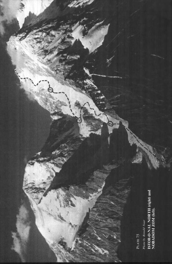
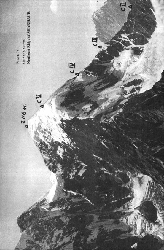

284 THE AMERICAN ALPINE JOURNAL
Kohe Bandaka. An expedition of the Klub Wysokogorski, Warsaw, made three ascents in the central Hindu Kush: P 6044 (I 9,830 feet) between Kohe Banadka and Kohe Bandaka Sakhi, a second ascent, by leader Jan Jaworski and Stan&Yaw Jaworski; Kohe Bandaka Sakhi (21,044 feet) via a new route, the southeast ridge, by Tomasz Czarski, Marek G,Yogoczowski and Andrzej Marczak; and Kohe Bandaka (22,450 feet) by Jacek Gierlidski, G,I’ogoczowski and Marczak. This last climb, made from August 7 to 10, was the first ascent from the Bandaka valley east of the mountain. The route ascended a 2.500-foot-high couloir to the southeast ridge.
POLSKI ZWIA~EK ALPINIZMU, Poland
ANTARCTICA
Peaks in Emmanuel Glacier Region. Walter Bonatti, Italy, and Gary Ball, New Zealand, have climbed several peaks in this area as they were rock-sampling. They have ascended Mount Lister, (13,205 feet), Mount Hooker, Salient Peak and others of which I did not catch the names and some unnamed peaks. Many were first ascents. Apparently they were subsidized by the US Antarctic Research Program of the National Science Foundation. Why can they get permission and support when American climbers may not?
DANIEL L. OSBORNE