215, 315W & 325C Cooper Street, Epping Planning...
22
215, 315W & 325C Cooper Street, Epping Planning Scheme Amendment Transport Evaluation Client // Riverlee Caruso Epping Pty Ltd Office // VIC Reference // V126360 Date // 09/02/18
Transcript of 215, 315W & 325C Cooper Street, Epping Planning...

215, 315W & 325C Cooper Street, Epping
Planning Scheme Amendment
Transport Evaluation
Client // Riverlee Caruso Epping Pty Ltd
Office // VIC
Reference // V126360
Date // 09/02/18
© GTA Consultants (GTA Consultants (VIC) Pty Ltd) 2018
The information contained in this document is confidential and
intended solely for the use of the client for the purpose for which it has
been prepared and no representation is made or is to be implied as
being made to any third party. Use or copying of this document in
whole or in part without the written permission of GTA Consultants
constitutes an infringement of copyright. The intellectual property
contained in this document remains the property of GTA Consultants. TIA
/RSA
MA
- V
IC (
160805 v
7.1
3)
Melbourne | Sydney | Brisbane
Canberra | Adelaide | Perth
Gold Coast | Townsville
215, 315W & 325C Cooper Street, Epping
Planning Scheme Amendment
Transport Evaluation
Issue: D 09/02/18
Client: Riverlee Caruso Epping Pty Ltd
Reference: V126360
GTA Consultants Office: VIC
Quality Record
Issue Date Description Prepared By Checked By Approved By Signed
A 25/01/17 Final Anna Scott Andrew Farran John Kiriakidis
B 08/03/17 Updated Final Anna Scott Andrew Farran John Kiriakidis
C 07/02/18 Revised Final Jeremy Lis Andrew Farran John Kiriakidis
D 09/02/18 Revised Final Jeremy Lis Andrew Farran John Kiriakidis

V126360 // 09/02/18
Transport Evaluation // Issue: D
215, 315W & 325C Cooper Street, Epping, Planning Scheme Amendment
Table of Contents
1. Introduction 5
1.1 Background 5
2. Existing Transport Context 6
2.1 Subject Site 6
2.2 Road Network 7
2.3 SmartRoads Policy 8
2.4 Active Travel Infrastructure 9
2.5 Public Transport Accessibility 9
2.6 Existing Travel Behaviour 10
3. Future Transport Considerations 12
3.1 Epping Central Structure Plan 12
3.2 Other Relevant Transport Considerations 14
4. Amendment C213 15
4.1 Land Uses 15
4.2 Vehicle Access 15
5. Traffic Impact 17
5.1 Traffic Generation 17
5.2 Intersection Control 18
5.3 Further Analysis 19
5.4 Public Transport Accessibility 19
6. Conclusion 21
Figures
Figure 2.1: Subject Site and its Environs 6
Figure 2.2: Land Zoning Map 7
Figure 2.3: VicRoads SmartRoads Network Operating Plan – Whittlesea 9
Figure 2.4: Public Transport Map 10
Figure 3.1: Epping Central Structure Plan – Regional Context 12
Figure 3.2: Epping Central Structure Plan – Walking and Cycling Plan 13
Figure 3.3: Epping Central Structure Plan – Development Framework Plan 13
Figure 3.4: Location of Nearby Projects 14
Figure 4.1: Access Arrangements and Reference Map 16

V126360 // 09/02/18
Transport Evaluation // Issue: D
215, 315W & 325C Cooper Street, Epping, Planning Scheme Amendment
Tables
Table 2.1: Road Network Description 8
Table 2.3: Journey to Work by Place of Residence/Employment 11
Table 4.1: Summary of Zones and Uses Permitted by the Zone 15
Table 5.1: Existing Traffic Generation Estimates 17
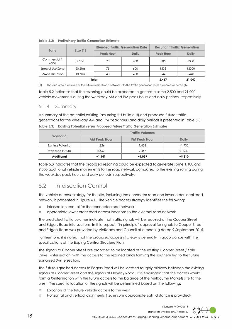
Table 5.2: Preliminary Traffic Generation Estimate 18
Table 5.3: Existing Potential versus Proposed Future Traffic Generation Estimates 18

V126360 // 09/02/18
Transport Evaluation // Issue: D
215, 315W & 325C Cooper Street, Epping, Planning Scheme Amendment 5
1. Introduction
1.1 Background
Amendment C213 to the Whittlesea Planning Scheme proposes to introduce new planning
controls to the site known as the Epping Renewal Site (referred to as 215, 315W & 325C Cooper
Street, Epping throughout this report). The site is currently zoned Industrial Zone 3 and is proposed
to be rezoned to accommodate a mix of land uses. The Development Plan Overlay (DPO)
requires the preparation of a Transport Management Plan as part of the Development Plan. This
report sets out a preliminary assessment of the transport impacts resulting from the proposed
rezoning.
1
V126360 // 09/02/18
Transport Evaluation // Issue: D
215, 315W & 325C Cooper Street, Epping, Planning Scheme Amendment 6
2. Existing Transport Context
2.1 Subject Site
The subject site is located at 215, 315W & 325C Cooper Street in Epping. The site of
approximately 510,000sqm has frontages of 650m to Cooper Street and 900m to Edgards Road.
Cooper Street and Edgars Road are located within a Road Zone 1.
The site is predominantly located within an Industrial Zone 3 and is currently occupied by a former
quarry. A parcel of land fronting Edgars Road is in a Priority Development Zone.
The surrounding properties include a mix of General Residential and Activity Centre land uses.
The Northern Hospital and Epping Plaza Shopping Centre are located to the east of the site, and
The Melbourne Market is located to the west of the site.
The location of the subject site and the surrounding environs is shown in Figure 2.1, and the land
zoning is shown in Figure 2.2.
Figure 2.1: Subject Site and its Environs
(Reproduced with Permission from Melway Publishing Pty Ltd)
2
Subject Site
V126360 // 09/02/18
Transport Evaluation // Issue: D
215, 315W & 325C Cooper Street, Epping, Planning Scheme Amendment 7
Figure 2.2: Land Zoning Map
(Reproduced from Land Channel web site)
2.2 Road Network
The subject site is bound by Cooper Street to the north, Edgars Road to the west, the future
Deveny Road to the south and the Northern Hospital to the east. Cooper Street and Edgars Road
are both configured with dual carriageways and are zoned as Road Zone 1 (VicRoads controlled
roads). High Street to the east of the site, beyond the Northern Hospital and Epping Plaza, is also
configured with a dual carriageway and zoned Road Zone 1.
Ultimately, Deveny Road is to be configured with a divided carriageway with two traffic lanes in
each direction. The first carriageway is currently under construction (as part of the Costco
development at 20 Jovic Road) and is expected to be completed in the first quarter of 2018.
Timing for the delivery of the second carriageway is unknown at this stage.
Vehicle access to the site is currently provided via a site access point to Cooper Street
approximately 150m east of the Willandra Drive intersection and 400m east of the Edgars Road
intersection. The existing vehicle access allows for left in, right in and left out movements to
Cooper Street and includes right and left turn deceleration lanes.
A description of each of the frontage roads is provided in Table 2.1.
Subject Site
V126360 // 09/02/18
Transport Evaluation // Issue: D
215, 315W & 325C Cooper Street, Epping, Planning Scheme Amendment 8
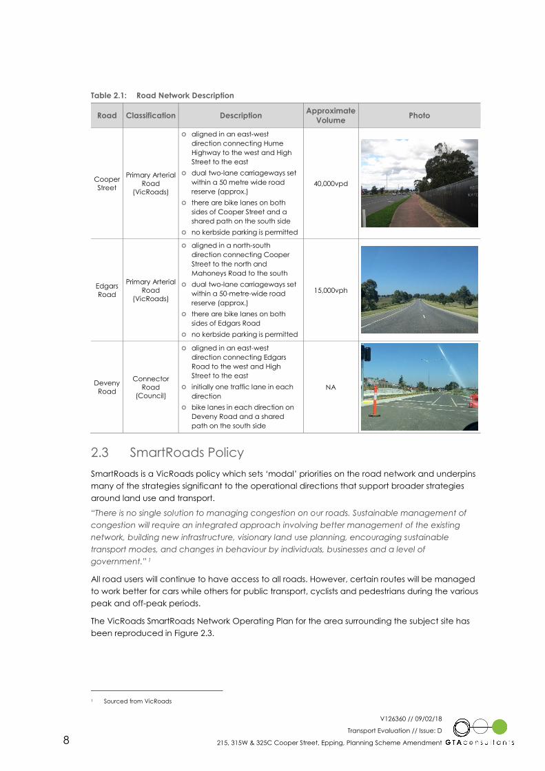
Table 2.1: Road Network Description
Road Classification Description Approximate
Volume Photo
Cooper
Street
Primary Arterial
Road
(VicRoads)
� aligned in an east-west
direction connecting Hume
Highway to the west and High
Street to the east
� dual two-lane carriageways set
within a 50 metre wide road
reserve (approx.)
� there are bike lanes on both
sides of Cooper Street and a
shared path on the south side
� no kerbside parking is permitted
40,000vpd
Edgars
Road
Primary Arterial
Road
(VicRoads)
� aligned in a north-south
direction connecting Cooper
Street to the north and
Mahoneys Road to the south
� dual two-lane carriageways set
within a 50-metre-wide road
reserve (approx.)
� there are bike lanes on both
sides of Edgars Road
� no kerbside parking is permitted
15,000vph
Deveny
Road
Connector
Road
(Council)
� aligned in an east-west
direction connecting Edgars
Road to the west and High
Street to the east
� initially one traffic lane in each
direction
� bike lanes in each direction on
Deveny Road and a shared
path on the south side
NA
2.3 SmartRoads Policy
SmartRoads is a VicRoads policy which sets ‘modal’ priorities on the road network and underpins
many of the strategies significant to the operational directions that support broader strategies
around land use and transport.
“There is no single solution to managing congestion on our roads. Sustainable management of
congestion will require an integrated approach involving better management of the existing
network, building new infrastructure, visionary land use planning, encouraging sustainable
transport modes, and changes in behaviour by individuals, businesses and a level of
government.” 1
All road users will continue to have access to all roads. However, certain routes will be managed
to work better for cars while others for public transport, cyclists and pedestrians during the various
peak and off-peak periods.
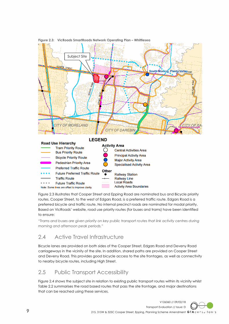
The VicRoads SmartRoads Network Operating Plan for the area surrounding the subject site has
been reproduced in Figure 2.3.
1 Sourced from VicRoads
V126360 // 09/02/18
Transport Evaluation // Issue: D
215, 315W & 325C Cooper Street, Epping, Planning Scheme Amendment 9
Figure 2.3: VicRoads SmartRoads Network Operating Plan – Whittlesea
Figure 2.3 illustrates that Cooper Street and Epping Road are nominated bus and Bicycle priority
routes. Cooper Street, to the west of Edgars Road, is a preferred traffic route. Edgars Road is a
preferred bicycle and traffic route. No internal precinct roads are nominated for modal priority.
Based on VicRoads’ website, road use priority routes (for buses and trams) have been identified
to ensure:
“Trams and buses are given priority on key public transport routes that link activity centres during
morning and afternoon peak periods.”
2.4 Active Travel Infrastructure
Bicycle lanes are provided on both sides of the Cooper Street, Edgars Road and Deveny Road
carriageways in the vicinity of the site. In addition, shared paths are provided on Cooper Street
and Deveny Road. This provides good bicycle access to the site frontages, as well as connectivity
to nearby bicycle routes, including High Street.
2.5 Public Transport Accessibility
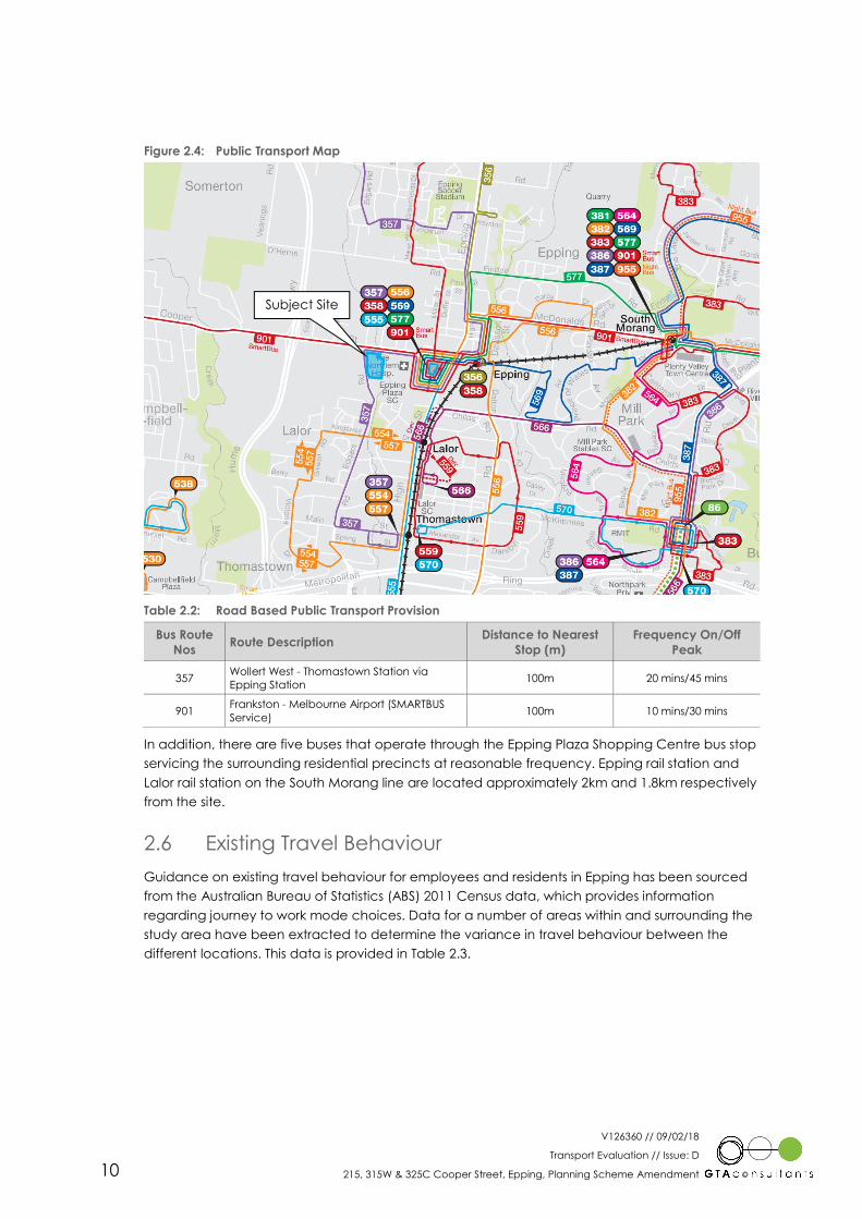
Figure 2.4 shows the subject site in relation to existing public transport routes within its vicinity whilst
Table 2.2 summarises the road based routes that pass the site frontage, and major destinations
that can be reached using these services.
Subject Site
V126360 // 09/02/18
Transport Evaluation // Issue: D
215, 315W & 325C Cooper Street, Epping, Planning Scheme Amendment 10
Figure 2.4: Public Transport Map
Table 2.2: Road Based Public Transport Provision
Bus Route
Nos Route Description
Distance to Nearest
Stop (m)
Frequency On/Off
Peak
357 Wollert West - Thomastown Station via
Epping Station 100m 20 mins/45 mins
901 Frankston - Melbourne Airport (SMARTBUS
Service) 100m 10 mins/30 mins
In addition, there are five buses that operate through the Epping Plaza Shopping Centre bus stop
servicing the surrounding residential precincts at reasonable frequency. Epping rail station and
Lalor rail station on the South Morang line are located approximately 2km and 1.8km respectively
from the site.
2.6 Existing Travel Behaviour
Guidance on existing travel behaviour for employees and residents in Epping has been sourced
from the Australian Bureau of Statistics (ABS) 2011 Census data, which provides information
regarding journey to work mode choices. Data for a number of areas within and surrounding the
study area have been extracted to determine the variance in travel behaviour between the
different locations. This data is provided in Table 2.3.
Subject Site
V126360 // 09/02/18
Transport Evaluation // Issue: D
215, 315W & 325C Cooper Street, Epping, Planning Scheme Amendment 11
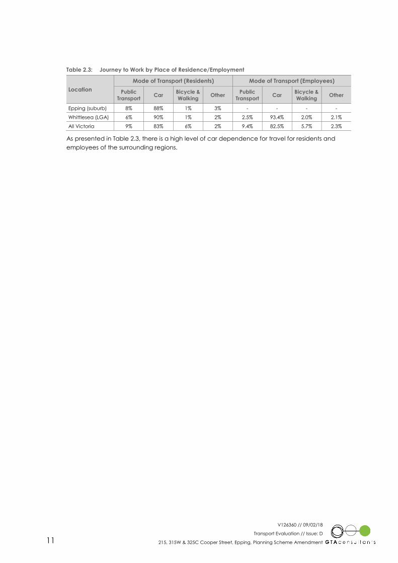
Table 2.3: Journey to Work by Place of Residence/Employment
Location
Mode of Transport (Residents) Mode of Transport (Employees)
Public
Transport Car
Bicycle &
Walking Other
Public
Transport Car
Bicycle &
Walking Other
Epping (suburb) 8% 88% 1% 3% - - - -
Whittlesea (LGA) 6% 90% 1% 2% 2.5% 93.4% 2.0% 2.1%
All Victoria 9% 83% 6% 2% 9.4% 82.5% 5.7% 2.3%
As presented in Table 2.3, there is a high level of car dependence for travel for residents and
employees of the surrounding regions.
V126360 // 09/02/18
Transport Evaluation // Issue: D
215, 315W & 325C Cooper Street, Epping, Planning Scheme Amendment 12
3. Future Transport Considerations
3.1 Epping Central Structure Plan
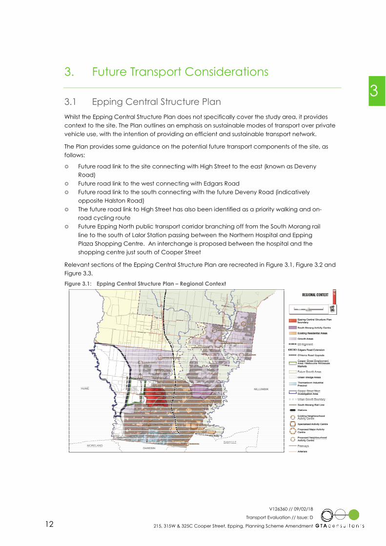
Whilst the Epping Central Structure Plan does not specifically cover the study area, it provides
context to the site. The Plan outlines an emphasis on sustainable modes of transport over private
vehicle use, with the intention of providing an efficient and sustainable transport network.
The Plan provides some guidance on the potential future transport components of the site, as
follows:
� Future road link to the site connecting with High Street to the east (known as Deveny
Road)
� Future road link to the west connecting with Edgars Road
� Future road link to the south connecting with the future Deveny Road (indicatively
opposite Halston Road)
� The future road link to High Street has also been identified as a priority walking and on-
road cycling route
� Future Epping North public transport corridor branching off from the South Morang rail
line to the south of Lalor Station passing between the Northern Hospital and Epping
Plaza Shopping Centre. An interchange is proposed between the hospital and the
shopping centre just south of Cooper Street
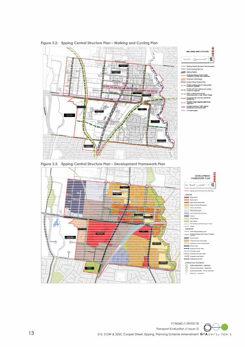
Relevant sections of the Epping Central Structure Plan are recreated in Figure 3.1, Figure 3.2 and
Figure 3.3.
Figure 3.1: Epping Central Structure Plan – Regional Context
3
V126360 // 09/02/18
Transport Evaluation // Issue: D
215, 315W & 325C Cooper Street, Epping, Planning Scheme Amendment 13
Figure 3.2: Epping Central Structure Plan – Walking and Cycling Plan
Figure 3.3: Epping Central Structure Plan – Development Framework Plan
V126360 // 09/02/18
Transport Evaluation // Issue: D
215, 315W & 325C Cooper Street, Epping, Planning Scheme Amendment 14
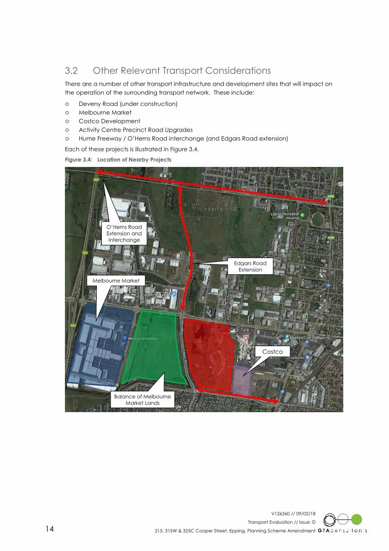
3.2 Other Relevant Transport Considerations
There are a number of other transport infrastructure and development sites that will impact on
the operation of the surrounding transport network. These include:
� Deveny Road (under construction)
� Melbourne Market
� Costco Development
� Activity Centre Precinct Road Upgrades
� Hume Freeway / O’Herns Road interchange (and Edgars Road extension)
Each of these projects is illustrated in Figure 3.4.
Figure 3.4: Location of Nearby Projects
Melbourne Market
Costco
Balance of Melbourne
Market Lands
O’Herns Road
Extension and
Interchange
Edgars Road
Extension

V126360 // 09/02/18
Transport Evaluation // Issue: D
215, 315W & 325C Cooper Street, Epping, Planning Scheme Amendment 15
4. Amendment C213
4.1 Land Uses
The proposal includes the development of various precincts, which will include a range of land
uses, with the land areas and uses permitted by the zone summarised in Table 4.1.
Table 4.1: Summary of Zones and Uses Permitted by the Zone
Zoning Size Uses Permitted by the Zone
Commercial 1 Zone 5.5ha Shop, Office, Warehouse, Showrooms, Hotel, Residential
Special Use Zone 20.5ha Residential, Hospital, Medical Suites, Retirement Village, Aged Care, Child
Care, Hotel, Office
Mixed Use Zone 13.6ha Residential, Office, Showrooms, Retirement Village, Aged Care, Child Care,
Hotel
In addition, land area has been set aside for water bodies, habitat and open space.
The Development Plan Overlay requires the preparation of a Transport Management Plan. The
specific requirements of the Transport Management Plan are reproduced below:
“Transport Management Plan
� Identification of the existing road network hierarchy, intersections, public transport,
cycling and pedestrian infrastructure and traffic volumes surrounding the site;
� Identification of the indicative road network within the site and the proposed
connections within and externally to the site with a focus on how the road and
pedestrian/cycle pathways within the site will be designed to integrate with adjoining
and surrounding land;
� Provision of recommended cross-sections of the internal road network, having regard to
the street tree planting proposed by the Open Space and Landscape Plan and the
promotion of sustainable personal transport; and
� Details of the proposed and possible future sustainable transport opportunities,
including public transport connections, walking and cycling infrastructure and
connections to the Epping Metropolitan Activity Centre and existing and future public
transport.”
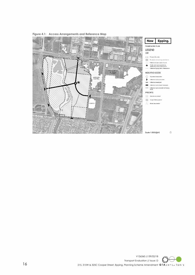
4.2 Vehicle Access
Vehicle access to the site is proposed via three higher order connections to the future
surrounding road network, as follows:
� Cooper Street (to the north)
� Edgars Road (to the west)
� Future Connector Road (to the east)
The higher order connections will be supplemented by a number of lower order access points to
and from Deveny Road and Edgars Road.
Figure 4.1 on the following page shows the proposed access arrangements to the site, including
the internal high order road network (connector level) and shared path network.
4
V126360 // 09/02/18
Transport Evaluation // Issue: D
215, 315W & 325C Cooper Street, Epping, Planning Scheme Amendment 16
Figure 4.1: Access Arrangements and Reference Map

V126360 // 09/02/18
Transport Evaluation // Issue: D
215, 315W & 325C Cooper Street, Epping, Planning Scheme Amendment 17
5. Traffic Impact
5.1 Traffic Generation
5.1.1 Preamble
The site is currently zoned Industrial Zone 3 and as such, could support significant land use
intensification beyond the current land uses provided on-site. Indeed, if the site was developed
in accordance with its current zoning it would be expected to generate significantly more traffic
than its current land uses/operations.
Therefore, the additional traffic generated by the rezoning is considered to be the difference
between the site’s potential traffic generations under its current zoning compared to the
anticipated traffic generation under its proposed rezoning. In this respect, an assessment of the
site’s potential traffic generation under its current zoning and anticipated traffic generation
under the proposed rezoning is presented below.
5.1.2 Existing Zoning
The site has a developable area of approximately 39 hectares (i.e. excluding habitat and
wetland areas). Assuming a site coverage of 60-65% the site would be capable of
accommodating 255,000sqm of industrial area.
Traffic generation estimates for the proposed development have been sourced from the RMS
Guide to Traffic Generating Development (2013). Estimates of the potential peak hour and daily
traffic volumes generated by the existing land zoning are set out in Table 5.1.
Table 5.1: Existing Traffic Generation Estimates
Period Potential Floor Area Traffic Generation Rate
(Movements/100sqm of GFA) Vehicle Movements
AM Peak Hour
255,000sqm
0.52 1,326
PM Peak Hour 0.56 1,428
Daily 4.60 11,730
Table 5.1 indicates that the site could potentially generate some 1,300, 1,400 and 11,700 vehicle
movements during the weekday AM and PM peak hours and daily periods, respectively.
5.1.3 Proposed Zoning
The proposed zoning allows for the development of a range of land uses, each with a distinct
traffic generation profile. In this respect, GTA has sourced traffic volume estimates from a number
of sources, as follows:
� RMS Guide to Traffic Generating Developments (2002 and 2013)
� GTA traffic survey database
Utilising the above data, GTA has developed blended traffic generation rates for each of the
proposed zone types. Table 5.2 presents a summary of the anticipated traffic generation from the
rezoned lands, adopting the relevant traffic generation rates from the above sources.
5
V126360 // 09/02/18
Transport Evaluation // Issue: D
215, 315W & 325C Cooper Street, Epping, Planning Scheme Amendment 18
Table 5.2: Preliminary Traffic Generation Estimate
Zone Size [1] Blended Traffic Generation Rate Resultant Traffic Generation
Peak Hour Daily Peak Hour Daily
Commercial 1
Zone 5.5ha 70 600 385 3300
Special Use Zone 20.5ha 75 600 1538 12300
Mixed Use Zone 13.6ha 40 400 544 5440
Total 2,467 21,040
[1] This land area is inclusive of the future internal road network with the traffic generation rates prepared accordingly.
Table 5.2 indicates that the rezoning could be expected to generate some 2,500 and 21,000
vehicle movements during the weekday AM and PM peak hours and daily periods, respectively.
5.1.4 Summary
A summary of the potential existing (assuming full build out) and proposed future traffic
generations for the weekday AM and PM peak hours and daily periods is presented in Table 5.3.
Table 5.3: Existing Potential versus Proposed Future Traffic Generation Estimates
Scenario Traffic Volumes
AM Peak Hour PM Peak Hour Daily
Existing Potential 1,326 1,428 11,730
Proposed Future 2,467 2,467 21,040
Additional +1,141 +1,039 +9,310
Table 5.3 indicates that the proposed rezoning could be expected to generate some 1,100 and
9,000 additional vehicle movements to the road network compared to the existing zoning during
the weekday peak hours and daily periods, respectively.
5.2 Intersection Control
The vehicle access strategy for the site, including the connector road and lower order local road
network, is presented in Figure 4.1. The vehicle access strategy identifies the following:
� intersection control for the connector road network
� appropriate lower order road access locations to the external road network
The predicted traffic volumes indicate that traffic signals will be required at the Cooper Street
and Edgars Road intersections. In this respect, “in principle” approval for signals to Cooper Street
and Edgars Road was provided by VicRoads and Council at a meeting dated 9 September 2015.
Furthermore, it is noted that the proposed access strategy is generally in accordance with the
specifications of the Epping Central Structure Plan.
The signals to Cooper Street are proposed to be located at the existing Cooper Street / Yale
Drive T-intersection, with the access to the rezoned lands forming the southern leg to the future
signalised X-intersection.
The future signalised access to Edgars Road will be located roughly midway between the existing
signals at Cooper Street and the signals at Deveny Road. It is envisaged that the access would
form a X-intersection with the future access to the balance of the Melbourne Markets site to the
west. The specific location of the signals will be determined based on the following:
� Location of the future vehicle access to the west
� Horizontal and vertical alignments (i.e. ensure appropriate sight distance is provided)
V126360 // 09/02/18
Transport Evaluation // Issue: D
215, 315W & 325C Cooper Street, Epping, Planning Scheme Amendment 19
� Other environmental factors (sensitive ecology, drainage corridors, etc.)
The indicative location of the lower order local road access opportunities to the surrounding road
network have been based on the following principles:
� Offset from signalised intersections by a minimum 200m on arterial roads (i.e. Cooper
Street and Edgars Road) and be limited to left in / left out only as per the requirements
of VicRoads Access Management Polices (draft document).
� Offset from signalised intersections by a minimum 100m on Council roads (i.e. Deveny
Road) as per VicRoads standard intersection drawings.
The access point to Deveny Road is envisaged to be priority controlled. Vehicles accessing the
site to and from the site will use Deveny Road to access Edgars Road to the west and High Street
to the east.
It is anticipated that appropriate mitigating works can be provided to cater for the predicted
level of traffic to be generated by the rezoned lands, without compromising the safety or
function of the surrounding road network.
5.3 Further Analysis
The preparation of a Transport Management Plan is required under the proposed Development
Plan Overlay. The specific requirements of the Transport Management Plan are reproduced
below:
“Transport Management Plan
� Identification of the existing road network hierarchy, intersections, public transport,
cycling and pedestrian infrastructure and traffic volumes surrounding the site;
� Identification of the indicative road network within the site and the proposed
connections within and externally to the site with a focus on how the road and
pedestrian/cycle pathways within the site will be designed to integrate with adjoining
and surrounding land;
� Provision of recommended cross-sections of the internal road network, having regard to
the street tree planting proposed by the Open Space and Landscape Plan and the
promotion of sustainable personal transport; and
� Details of the proposed and possible future sustainable transport opportunities,
including public transport connections, walking and cycling infrastructure and
connections to the Epping Metropolitan Activity Centre and existing and future public
transport.”
As such, the detailed traffic analysis will be undertaken as part of the Transport Management
Plan required by the Development Plan Overlay. This will include a detailed assessment of the
surrounding road network, including the interface intersections. This assessment will identify the
future mitigating works, intersection layouts (number of lanes, length of turn lanes, etc.) and future
road reserve boundaries.
5.4 Public Transport Accessibility
The ‘Public Transport: Guidelines for Land Use and Development’ document prepared by the
Department of Transport (DoT) provides guidance on the recommended public transport
provisions and coverage for new developments. Specifically, the document states the following
for bus routes:
“Neighbourhoods should be designed for bus routes on strategically located connector roads so
that dwellings will be within 400 metres of a bus route.”

V126360 // 09/02/18
Transport Evaluation // Issue: D
215, 315W & 325C Cooper Street, Epping, Planning Scheme Amendment 20
In this regard, all connector roads within the study area are proposed to be bus capable links.
Should a bus route be realised on the internal road network (or on Deveny Road) 100% of
dwellings would be located within 400m of a bus route. Ideally, a future bus route could be
aligned along the central east-west connector street and connect to the existing Epping
Shopping Centre bus interchange (and potential future public transport corridor interchange
anticipated as part of the Epping Central Structure Plan) from the south.
Notwithstanding, should an internal bus route not be realised immediately approximately 80% of
the subject site is currently located within 400m of an existing bus route.
V126360 // 09/02/18
Transport Evaluation // Issue: D
215, 315W & 325C Cooper Street, Epping, Planning Scheme Amendment 21
6. Conclusion
Based on the analysis and discussions presented within this report, the following conclusions are
made:
i The subject site is approximately 510,000sqm and is bound by Cooper Street to the
north, Edgars Road to the west, Deveny Road to the south and the Northern Hospital to
the east.
ii The site is currently zoned Industrial Zone 3 and is proposed to be rezoned for higher
order zoning. The Framework Plan includes Special Use, Cooper Street and Mixed Use
precincts.
iii There are a number of significant transport projects and development sites that will alter
the future transport situation surrounding the site, as noted in the report.
iv The site is currently zoned as an Industrial Zone 3 and has the potential to generate up
to some 1,400 and 11,700 vehicle movements during the weekday peak hours and
daily periods, respectively.
v The land uses permitted by the proposed new zones for the site could generate up to
some 2,500 and 21,000 vehicle movements during the weekday peak hours and daily
periods, respectively. This represents an increase of approximately 1,100 and 9,000
additional vehicle movements during the weekday peak hours and daily periods,
respectively compared to the site current traffic generation potential.
vi VicRoads and Council have provided “in principle” approval for the proposed
signalised access points to Cooper Street and Edgars Road.
vii A Transport Management Plan containing detailed traffic modelling will be completed
as part of the preparation of the Development Plan for the site.
6

Melbourne
A Level 25, 55 Collins Street
PO Box 24055
MELBOURNE VIC 3000
P +613 9851 9600
Brisbane
A Ground Floor, 283 Elizabeth Street
BRISBANE QLD 4000
GPO Box 115
BRISBANE QLD 4001
P +617 3113 5000
Adelaide
A Suite 4, Level 1, 136 The Parade
PO Box 3421
NORWOOD SA 5067
P +618 8334 3600
Sydney
A Level 6, 15 Help Street
CHATSWOOD NSW 2067
PO Box 5254
WEST CHATSWOOD NSW 1515
P +612 8448 1800
Canberra
A Level 4, 15 Moore Street
CANBERRA ACT 2600
P +612 6243 4826
Perth
A Level 2, 5 Mill Street
PERTH WA 6000
PO Box 7025, Cloisters Square
PERTH WA 6850
P +618 6169 1000
www.gta.com.au www.gta.com.au