
2.13 Public Services - SanDiegoCounty.gov · Police Protection Services Potentially significant...
38
2.13 Public Services San Diego County Property Specific Requests General Plan Amendment and Rezone SEIR Page 2.13-1 2.13 Public Services This section identifies the existing public services, including fire protection, police protection, schools, and other services within the PSR Analysis Areas and the former CGSP Area, and analyzes the potential effects of the Proposed Project on these resources. Information contained in this section has been incorporated from the County of San Diego Guidelines for Determining Significance, Wildland Fire and Fire Protection (DPLU 2010), and from the data included in the 2011 PEIR, which has been updated, as discussed below. Appendix G of the CEQA Guidelines requires the analysis of impacts to parks within the Public Services section; the reader is referred to Section 2.14 (Recreation) in this SEIR for the analysis of impacts to parks. A summary of the impacts to public services identified in Section 2.13.3 is provided below. Public Services Summary of Impacts Issue Topic Project Direct Impact Cumulative Impact Impact After Mitigation Fire Protection and Emergency Response Services Potentially significant Potentially significant Less than significant Police Protection Services Potentially significant Potentially significant Less than significant School Services Potentially significant Potentially significant Significant and unavoidable Other Public Services Potentially significant Potentially significant Less than significant 2.13.1 Existing Conditions Section 2.13.1 of the 2011 PEIR included a discussion of existing conditions related to public services, including fire protection, police protection, schools, and other services that serve the unincorporated County. The public services data conditions described in the 2011 PEIR have been updated below with recent data that is now available. While the data has been updated, the changes do not alter the conclusions from the 2011 PEIR. All references used from the 2011 PEIR were reviewed, and are hereby incorporated by reference. 2.13.1.1 Fire Protection Within the nine CPAs/Subregions associated with the Proposed Project, fire and emergency medical services are provided by Fire Protection Districts (FPD), County Service Areas (CSA), and the CAL FIRE. Table 2.13-1 identifies the FPDs that serve the PSR Analysis Areas and the former CGSP Area, and Figure 2.13-1 identifies the service area of each FPD. A summary of each district is provided below. U.S. Forest Service The USFS is responsible for fire protection and prevention on federal lands (Federal Responsibility Areas) and private lands within the boundaries of the Cleveland National Forest. USFS operates a total of 12 fire stations in San Diego County (see Figure 2.13-1), and one station in Riverside County. USFS stations in Ramona and Descanso are open year-round, while the others are only open during the fire season (late summer/fall). Approximately 42 percent of the USFS emergency calls are related to fire suppression, while 50 percent are related to law enforcement. Fires on military installations are suppressed by the Department of Defense installation forces. In some instances, Department of Defense installations request assistance from other federal, State or local agencies. Tribal reservation fire departments also provide mutual
Transcript of 2.13 Public Services - SanDiegoCounty.gov · Police Protection Services Potentially significant...

2.13 Public Services
San Diego County Property Specific Requests General Plan Amendment and Rezone SEIR
Page 2.13-1
2.13 Public Services
This section identifies the existing public services, including fire protection, police protection, schools, and other services within the PSR Analysis Areas and the former CGSP Area, and analyzes the potential effects of the Proposed Project on these resources. Information contained in this section has been incorporated from the County of San Diego Guidelines for Determining Significance, Wildland Fire and Fire Protection (DPLU 2010), and from the data included in the 2011 PEIR, which has been updated, as discussed below. Appendix G of the CEQA Guidelines requires the analysis of impacts to parks within the Public Services section; the reader is referred to Section 2.14 (Recreation) in this SEIR for the analysis of impacts to parks.
A summary of the impacts to public services identified in Section 2.13.3 is provided below.
Public Services Summary of Impacts
Issue Topic Project Direct Impact Cumulative Impact Impact After Mitigation
Fire Protection and Emergency Response Services
Potentially significant Potentially significant Less than significant
Police Protection Services Potentially significant Potentially significant Less than significant
School Services Potentially significant Potentially significant Significant and unavoidable
Other Public Services Potentially significant Potentially significant Less than significant
2.13.1 Existing Conditions
Section 2.13.1 of the 2011 PEIR included a discussion of existing conditions related to public services, including fire protection, police protection, schools, and other services that serve the unincorporated County. The public services data conditions described in the 2011 PEIR have been updated below with recent data that is now available. While the data has been updated, the changes do not alter the conclusions from the 2011 PEIR. All references used from the 2011 PEIR were reviewed, and are hereby incorporated by reference.
2.13.1.1 Fire Protection
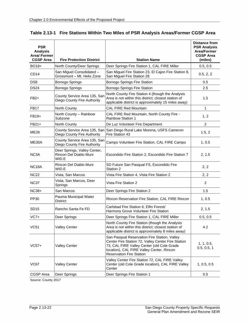
Within the nine CPAs/Subregions associated with the Proposed Project, fire and emergency medical services are provided by Fire Protection Districts (FPD), County Service Areas (CSA), and the CAL FIRE. Table 2.13-1 identifies the FPDs that serve the PSR Analysis Areas and the former CGSP Area, and Figure 2.13-1 identifies the service area of each FPD. A summary of each district is provided below.
U.S. Forest Service
The USFS is responsible for fire protection and prevention on federal lands (Federal Responsibility Areas) and private lands within the boundaries of the Cleveland National Forest. USFS operates a total of 12 fire stations in San Diego County (see Figure 2.13-1), and one station in Riverside County. USFS stations in Ramona and Descanso are open year-round, while the others are only open during the fire season (late summer/fall). Approximately 42 percent of the USFS emergency calls are related to fire suppression, while 50 percent are related to law enforcement. Fires on military installations are suppressed by the Department of Defense installation forces. In some instances, Department of Defense installations request assistance from other federal, State or local agencies. Tribal reservation fire departments also provide mutual

Chapter 2.0 Environmental Effects of the Proposed Project
Page 2.13-2 San Diego County Property Specific Requests General Plan Amendment and Rezone SEIR
fire service assistance to unincorporated County areas that are near or bordering the reservation community area.
California Department of Forestry and Fire Protection
CAL FIRE is an emergency response and resource protection department that responds to more than 5,600 wildland fires that burn over 172,000 acres in the State on average each year. In addition, department personnel respond on average to more than 300,000 other emergency calls including structure fires, automobile accidents, medical aid, swift water rescues, civil disturbance, search and rescue, floods, and earthquakes. CAL FIRE is the State’s largest fire protection organization, whose fire protection team includes extensive ground forces, supported by a variety of fire-fighting equipment. CAL FIRE has joined with federal and local agencies to form a statewide mutual aid system. This system ensures a rapid response of emergency equipment by being able to draw on all available resources regardless of jurisdiction.
As the principal contractor, CAL FIRE is responsible for wildland fire protection on 1.2 million acres within the County. CAL FIRE is responsible for fire response services within more than 50 percent of the unincorporated County’s total land area, and provides watershed and fire protection on approximately 2,200 square miles of land. Within the County, CAL FIRE operates 18 stations (Figure 2.13-1), including one air attack base in Ramona. CAL FIRE will respond to structural and vehicular fires and medical emergencies when requested by another fire agency or when these fires threaten to spread to wildlands. CAL FIRE protection areas include State Responsibility Area where CAL FIRE has responsibility for emergency services, and Local Responsibility Areas where CAL FIRE provides emergency service support for CSAs and fire districts via contracts with the County. Each of the 18 CAL FIRE stations in the County is staffed with three career firefighters during fire season (CAL FIRE 2017).
Local Fire Districts
The fire protection districts (or agencies) that serve the PSR Analysis Areas and the former CGSP Area can be broadly classified as independent agencies or dependent agencies. Independent agencies have a directly elected Board of Directors. Dependent agencies rely on elected officials from other levels of local government. Regardless of classification, each of the fire protection agencies is autonomous. Each local government is able to craft unique policies and practices and each agency is empowered, within the limits of State law, to make independent fiscal decisions.
Borrego Springs Fire Protection District
Formed in 1961, the District surrounds the community of Borrego Springs, encompassing an area of 305.5 square miles. The District provides structural and wildland fire suppression (though wildland fire protection is largely the responsibility of CAL FIRE), fire prevention, rescue services, and Advanced Life Support (ALS) ambulance medical services from one station. Borrego Springs Fire Protection District services PSR Analysis Areas DS8 and DS24.
Deer Springs Fire Protection District
This District is located north of the City of Escondido, northeast of the City of San Marcos, and covers approximately 45 square miles. This FPD serves the Bonsall CPA, Valley Center CPA, and the North County Metro Subregion. Established in December 1981, the District, under a cooperative fire protection agreement with CAL FIRE, provides structural fire protection, rescue, Emergency Medical Service (EMS) with Emergency Medical Technicians, inspection, and fire prevention programs from three fire stations. ALS ambulance service is provided through the

2.13 Public Services
San Diego County Property Specific Requests General Plan Amendment and Rezone SEIR
Page 2.13-3
Valley Center ALS Ambulance Service Area. The Deer Springs FPD services PSR Analysis Areas BO18+ (portion), NC3A (portion), NC37 (portion), VC7+, and all former CGSP Subareas.
North County Fire Protection District
This FPD encompasses 92 square miles, including the communities of Bonsall, Fallbrook, and Rainbow in northern San Diego County. The District provides structural and wildland fire protection (though wildland responsibility lies with CAL FIRE), as well as paramedic first-responder and ambulance transport emergency medical services, rescue and fire prevention. The District operates from six stations. The District also provides administrative support to the Rainbow Volunteer Fire Department (CSA), which became part of the District in 1986. North County FPD services PSR Analysis Areas BO18+ (portion), FB17, FB19+, and FB21+.
San Diego Rural Fire Protection District
Since 1983, PSR Analysis Area ME26 received fire protection service under the Rural Fire Protection District via a contract with the County Fire Authority. The San Diego Rural Fire District has recently been dissolved. The County Fire Authority currently holds jurisdiction over this analysis area.
San Marcos Fire Protection District
The San Marcos FPD is a subsidiary district of the City of San Marcos and serves portions of the North County Metro Subregion. The District encompasses 33 square miles, including 24 square miles located within the San Marcos city limits. As of March 2008, the District operates from four stations located throughout the San Marcos city limits. Paramedic service is available from each station through the use of paramedic engine companies. The District also provides paramedic ambulance transport service. PSR Analysis Areas NC22 (portion), NC37 (portion), and NC38+ are serviced by the San Marcos FPD.
San Miguel Consolidated Fire Protection District
San Miguel Consolidated FPD, which provides service to PSR Analysis Area CD14, is located east of the cities of San Diego and Lemon Grove, south of the cities of La Mesa and El Cajon, and west of the communities of Jamul. The San Miguel Consolidated FPD covers approximately 56.3 square miles of unincorporated territory. The FPD provides structural fire protection, wildland fire suppression, rescue and emergency medical services (paramedic engine company), code compliance, fire prevention and education to the communities of Spring Valley, Casa de Oro, La Presa, Grossmont/Mount Helix, Bostonia, Crest, and Rancho San Diego. Paramedic ambulance transport is provided through the Grossmont Health Care District I.
Valley Center Fire Protection District
The Valley Center FPD covers an area of 83 square miles in and around the community of Valley Center, north of the City of Escondido and east of I-15. Under a cooperative fire protection agreement with CAL FIRE, the District provides structural and wildland fire suppression, though primary responsibility for wildfire remains largely under CAL FIRE, and EMS, with service provided to the District from two stations. Ambulance service is provided through the Valley Center ALS Ambulance Service Area. PSR Analysis Areas NC3A (portion), VC51, VC57+, and VC67 are serviced by the Valley Center FPD.

Chapter 2.0 Environmental Effects of the Proposed Project
Page 2.13-4 San Diego County Property Specific Requests General Plan Amendment and Rezone SEIR
Vista Fire Protection District
Fire protection to the Vista FPD area was initially provided by the all-volunteer Vista Rural FPD formed in 1928. The Vista FPD was adopted by the County BOS on July 14, 1944. In 1963, when the City of Vista was incorporated, it removed 12 square miles from the District with the two entities sharing pro rata costs. The Vista FPD was set up to serve both agencies equally. The Vista FPD covers approximately 19 square miles and a population of 11,105. The service area of the Vista City Fire Department, including both the City and the District is approximately 38 square miles and serves portions of the North County Metro Subregion. The City of Vista Fire Department has four stations and is building two new stations. It also provides paramedic ambulances transport services within the City and District. PSR Analysis Area NC22 (portion) and NC37 (portion) are serviced by the Vista FPD.
Rancho Santa Fe Fire Protection District
Formed in 1946, the Rancho Santa Fe FPD provides services to a residential area of approximately 42 square miles, located between I-5 and I-15 north of San Diego city limits, including PSR Analysis Area SD15, within the San Dieguito CPA. The District provides structural and wildland fire protection, though primary responsibility for wildfire remains largely under CAL FIRE, EMS includes basic life service and ALS first-response, as well as rescue, prevention, and community education. The Department operates from four fire stations. ALS ambulance transport service is provided through CSA 17.
Rincon Del Diablo Municipal Water District
In 1976, Rincon Del Diablo Municipal Water District established Improvement District 10 “E” to provide fire protection, paramedic ambulance transport, and emergency services to residents within the District service area. Containing unincorporated areas to the east, south, and west of Escondido, services are provided by contract with the City of Escondido signed in 1984. The contract for services covers all of 10 “E” that is outside the city boundary and the North County Metro Subregion. PSR Analysis Areas NC3A (portion) and NC18A are serviced by the Rincon Del Diablo Municipal Water District.
County Fire Authority
The San Diego County Fire Authority supports emergency medical and fire protection services to the unincorporated areas of San Diego County. Emergency services are provided by a combination of professionally trained volunteer and career staff. PSR Analysis Areas FB2+, ME26, and ME30A are serviced by the County Fire Authority.
Pauma Municipal Water District – CAL FIRE
Structural fire protection and emergency medical services within the Pauma Municipal Water District (PMWD), where PSR Analysis Area PP30 is located, is provided by CAL FIRE. The CAL FIRE operation responding to the PMWD is based at the CAL FIRE Rincon Station.
Travel Times
An indicator to determine adequate regional fire protection and emergency medical demand is the ability of the system to respond to every emergency within acceptable time parameters. Travel time is defined as the estimated time it will take for responding emergency personnel to reach the furthest structure in a proposed development project. Prior to approval of a development project, a finding must be made that sufficient fire protection is available or will be available concurrent with the need for all discretionary projects. If the appropriate emergency travel time cannot be

2.13 Public Services
San Diego County Property Specific Requests General Plan Amendment and Rezone SEIR
Page 2.13-5
met for a proposed discretionary development project, the project will be denied unless sufficient mitigation measures are included as a basis of approval based on the recommendations of County Planning and Development Services and the fire authority having jurisdiction.
The existing General Plan sets emergency response travel time standards as shown in Table 2.13-2. Adequate travel time for VR-2 to VR-30 and SR-1 designations is a maximum of 5 minutes; SR-2 and SR-4 designations is a maximum of 10 minutes; SR-10 and RL-20 designations is a maximum of 20 minutes; and RL-40, RL-80 designations allow a response time greater than 20 minutes. The current estimates for travel time applicable to each PSR Analysis Area, shown in Figure 2.13-2, are identified in Table 2.13-3.
Additionally, most fire departments, local districts, and service areas provide ambulance services to the unincorporated County. Most firefighters are certified to provide basic medical treatment, and it can be assumed that the amount of time it would take to provide basic life support services can be estimated using fire response times. Within the unincorporated region, topography, lack of public roads and highways, a prevalence of private roads that do not connect or permit through-access, plus large distances between fire protection and emergency medical facilities, prevent personnel from responding within the accepted travel time standards for protecting life and property.
2.13.1.2 Police Protection
The San Diego County Sheriff’s Department (SDSD) is the chief law enforcement agency in San Diego County. The SDSD service area covers approximately 4,200 square miles. SDSD facilities serving the PSR Analysis Areas and the former CGSP Area provide general law enforcement patrol, crime investigation, and crime prevention services. To effectively serve the PSR Analysis Areas, the SDSD Law Enforcement Services Bureau operations are organized under a system of command stations, substations, offices and storefronts (SDSD 2015). Ten command stations serve the PSR Analysis Areas and the former CGSP Area. Table 2.13-4 identifies the projected increase in population for the proposed PSR Analysis Areas and the former CGSP Area, the SDSD command stations and the communities they serve. Figure 2.13-3 shows the service areas for the SDSD.
In 2016, SDSD personnel received approximately 11,433 calls for service in the nine CPA/Subregions containing PSR Analysis Areas (ARJIS 2017). A call for service is registered when a citizen or law enforcement personnel requests assistance for public safety services. Examples of calls for service include crimes reported by the public such as burglaries, assaults, and thefts.
Calls are assigned a priority based on the nature of the incident and the level of urgency. Priority 1 is considered the highest priority and includes officer assistance and/or vehicular pursuit calls. Priority 2 calls include injured persons, robbery in progress, bomb threats, carjacking, rape, and stolen vehicles. Priority 3 calls include assaults, prowlers, disturbances, tampering with vehicles, and burglary alarms. Finally, Priority 4 calls are the lowest priority calls and include security checks, animal noise disturbances, traffic stops, harassing phone calls, illegal dumping, and abandoned vehicles. SDSD does not have adopted response time standards, because deputies respond to calls for service while they are already out on patrol and the response time will vary depending on the deputy’s current location, his/her availability (e.g., he/she may already be working on a higher priority call), and the type of call (e.g., a priority call may be a “cover call” requiring that two deputies respond and the call won’t be dispatched until two deputies are available).

Chapter 2.0 Environmental Effects of the Proposed Project
Page 2.13-6 San Diego County Property Specific Requests General Plan Amendment and Rezone SEIR
2.13.1.3 Public Schools
Public schools and educational facilities are mandated by the California Department of Education (CDE) and administered by the San Diego County Board of Education and the San Diego County Office of Education. Thirteen unified, elementary, and high school districts provide service to residents within the PSR Analysis Areas and the former CGSP Area. The former CGSP Area is serviced by both Bonsall Unified School District and Valley Center-Pauma Unified School District. Information for each school district, including the PSR Analysis Areas and the former CGSP Area served, number of schools, enrollment size, and potential increase in school-aged children resulting from the Proposed Project is provided in Table 2.13-5. In total, approximately 186 schools serve the PSR Analysis Areas and the former CGSP Area with an approximate total enrollment of 131,508 students (CDE 2017). Although one type of district might overlap with another type of district, districts of the same classification do not overlap with one another. For example, an elementary school district and a high school district might serve the same area; however, two elementary school districts would not have overlapping areas within both of their service boundaries. Figure 2.13-4, Figure 2.13-5, and Figure 2.13-6 present the boundaries for elementary schools, high schools, and unified school districts that serve the PSR Analysis Areas and the former CGSP Area.
2.13.1.4 County Libraries
The San Diego County Library (SDCL) system serves residents within the PSR Analysis Areas, and the former CGSP Area through library service areas including Borrego Springs, Campo, Crest, Fallbrook, North Bookmobile, Rancho San Diego, Rancho Santa Fe, San Marcos, Vista and Valley Center. Residents visited County library branches more than 5.6 million times in the fiscal year 2014-2015 and they borrowed over 11.1 million books, CDs, DVDs, and other material. SDCL’s community programming component drew approximately 710,000 visitors in 2014, a number that has more than doubled since 2008 (SDCL 2015).
In 1996, the County BOS adopted recommended Standards of Library Service. The minimum space service goal for the SDCL system is 0.5 square feet per capita. Library branches are assigned to a particular category based on a combination of factors including the size of branch location, the population served, and the volume of materials checked out. A particular branch category may change over time because of new construction or changes in population (increases or decreases). San Marcos County Library servicing PSR Analysis Areas NC3A, NC18A, NC22, and NC38+has a deficit of 32,676 square feet, and Vista County Library serving PSR Analysis Areas NC38+, has a deficit of 22,805 square feet, as shown in Table 2.13-6. San Marcos County Library and Vista County Library have the greatest deficit based on the square foot amount per population served.
SDCL anticipates increased demand for services due to anticipated development and population growth in unincorporated areas. County libraries serving PSR Analysis Areas BO18+, CD14, DS8, DS24, FB17, FB21+, NC3A, NC18A, NC22, NC37, and NC38+ have library facility deficiencies. PSR Analysis Areas ME26, ME30A, SD15, VC7+, VC57+, VC67, and the former CGSP Area are serviced by libraries with a surplus of facilities available. Table 2.13-6 lists County library facilities which service the PSR Analysis Areas and the former CGSP Area, by size and facility requirements, and Figure 2.13-7 presents their service areas.

2.13 Public Services
San Diego County Property Specific Requests General Plan Amendment and Rezone SEIR
Page 2.13-7
2.13.2 Regulatory Framework
Section 2.13.2 of the 2011 PEIR included a discussion of regulatory framework related to public services in the unincorporated County. The regulations described in the 2011 PEIR are the same as the regulations evaluated in this SEIR, with the exception of an update to CCR Title 24, Part 2 and Part 9 and County of San Diego Consolidated Fire Code described below. No changes to those regulations have been identified that would alter the conclusions from the 2011 PEIR. All references used from the 2011 PEIR were reviewed to ensure they are still valid today, and are hereby incorporated by reference.
California Code of Regulations Title 24, Part 2 and Part 9, California Building Code
CCR Part 2 of Title 24 refers to the regulations and general construction building standards of state adopting agencies, including administrative, fire and life safety and field inspection provisions. Part 2 is preassembled with the 2012 International Building Code with necessary California amendments. Part 9 refers to the California Fire Code, which contains fire safety-related building standards referenced in other parts of Title 24. The California Fire Code is preassembled with the 2012 Edition of the International Fire Code with necessary California amendments.
County of San Diego Consolidated Fire Code
California HSC Section 13869.7(a) provides that a fire protection district organized pursuant to Division 12 of the code may adopt building standards relating to fire and panic safety that are more stringent than the building standard adopted by the State Fire Marshal and contained in CBC standards. HSC Section 13869.7(c) requires a fire protection district to transmit its adopted ordinance to the county where the ordinance will apply and allows the legislative body of a county to ratify, modify or deny an adopted fire protection district ordinance. The fire protection districts within the boundaries of San Diego County, including the SMFD, have collaborated to adopt the 2013 California Fire Code. The 2014 Consolidated Fire Code is based upon the County’s 2014 Fire Code as currently amended and adopted in Title 9, Division 6, Chapter 1 of the County Code, subject to the modifications of each fire protection district to the CBC standards based upon their respective determinations as to what modifications are reasonably necessary because of local climatic, geological and topographical conditions within the district.
2.13.3 Analysis of Project Impacts and Determination of Significance
2.13.3.1 Issue 1: Fire Protection
Guidelines for Determination of Significance
Based on Appendix G of the CEQA Guidelines, the County of San Diego Guidelines for Determining Significance: Wildland Fire and Fire Protection (DPLU 2010), the project would have a significant impact on Fire protection if:
• The project would result in substantial adverse physical impacts that would hinder maintenance of acceptable service rations, response times, or other performance objectives for any of the public services.
• The project cannot demonstrate compliance with all applicable fire codes,

Chapter 2.0 Environmental Effects of the Proposed Project
Page 2.13-8 San Diego County Property Specific Requests General Plan Amendment and Rezone SEIR
• A comprehensive Fire Protection Plan has been accepted and the project is inconsistent with its recommendations
• The project does not meet emergency response objectives identified in the public facilities element of the General Plan or offer feasible alternatives that achieve comparable emergency response objectives.
Impact Analysis
Future development within the PSR Analysis Areas, with the exception of VC67, would potentially lead to population and housing growth generally into areas where infrastructure and service systems already exist. However, increasing population and housing in areas that are not currently able to meet travel time goals would result in the need for new or expanded fire facilities to be constructed so that acceptable travel times can be met.
Fire agencies servicing the PSR Analysis Areas and the former CGSP Area would experience a potential increase in dwelling units and population within their service areas with implementation of the Proposed Project. Fire agencies that would experience the greatest potential growth with implementation of the Proposed Project include Valley Center FPD (PSR Analysis Areas VC51, and VC57+), Deer Springs FPD (PSR Analysis Areas BO18+ (portion), NC3A (portion), NC37 (portion), VC7+, and all former CGSP Subareas), Borrego Springs FPD (PSR Analysis Areas DS8 and DS24), and Rancho Santa Fe FPD (PSR Analysis Area SD15).
Current land use designations, allowable fire response times associated with those land use designations, and current estimated fire response times are shown in Table 2.13-3. These response times are simply estimates from a GIS model that uses the closest fire station for the travel time reference point, whether it is in the applicable district or not. For example, with the FB2+ Analysis Area, the closest station is a North County FPD station approximately 1.5 miles away, but the closest County Service Area station (applicable district) is approximately 15 miles away. Although for most of the PSR Analysis Areas, the closest station is the applicable district or a CAL FIRE station for wildfire protection services. When a development application is submitted, the applicable district will have to note the travel time from their closest station.
The allowable fire response times for the proposed land use designations for each of the PSR Analysis Area are shown in Table 2.13-7. Estimates show that some of the PSR Analysis Areas, including, DS8, CD14, FB19+, ME26, ME30A, NC3A, PP30, VC7+, VC57+, VC67, and each Subarea of the former CGSP Area would still be able to meet service standard times under the Proposed Project. Under the Proposed Project, increasing density designations within PSR Analysis Areas BO18+, DS24, FB2+, FB17, FB21+, NC18A, NC22, NC37, NC38+, PP30, SD15, and VC51 would reduce allowed travel response times, with the reduced allowed times potentially resulting in future development that cannot meet travel times without the provision of additional access roads or new or physically altered facilities. To maintain or achieve acceptable travel time standards for fire protection, it is reasonably foreseeable that the provision of additional access roads and/or new or physically altered fire facilities would be required, which would have the potential to result in adverse environmental impacts. Therefore, a potentially significant impact to fire protection services would occur (Impact PS-1).
Adoption of the Valley Center Community Plan Residential Policy 8 Revision would allow for additional minimum lot size flexibility for residential clustering only within SR-2 or SR-4 areas and only within the sewer service area; however, the adoption would not result in an increase in the number of allowed dwelling units. The Revision would not change land use designations which are the basis for determining standard travel response times provided in Table S-1 of the General Plan Safety Element. The Valley Center Community Plan Residential Policy 8 Revision would not

2.13 Public Services
San Diego County Property Specific Requests General Plan Amendment and Rezone SEIR
Page 2.13-9
increase the need for fire protection because it would not allow growth beyond that identified in the General Plan. Therefore, adoption of the Valley Center Community Plan Policy 8 Revision would not have an impact on fire services.
At the programmatic level, compliance with all applicable fire codes and consistency with Fire Protection Plans cannot be addressed. However, development resulting from implementation of the Proposed Project would be required to follow the County of San Diego Consolidated Fire Code and would be assessed for compliance on a project-specific level. Comprehensive Fire Protection Plans adopted within CPAs servicing the PSR Analysis Areas and the former CGSP Area would be applicable to all future development resulting from implementation of the Proposed Project. Compliance with applicable comprehensive fire protection plans would be assessed on the project-specific level. Emergency response plans are further addressed in Section 2.7.3.7 of this SEIR.
Under the Proposed Project, increasing allowable land use density within PSR Analysis Areas BO18+, DS24, FB2+, FB17, FB21+, NC18A, NC22, NC37, NC38+, SD15, and VC51 would reduce allowed travel response times, in areas where this could result in future development that cannot meet travel response times without the provision of additional access roads and/or new or physically altered facilities. Therefore, the Proposed Project would result in a potentially significant impact associated with fire response times and the construction or expansion of fire protection facilities (Impact PS-1).
2.13.3.2 Issue 2: Police Protection Services
Guidelines for Determination of Significance
Based on Appendix G of the CEQA Guidelines, the Proposed Project would have a significant impact on police protection services if the project would result in substantial adverse physical impacts associated with the provision of new or physically altered governmental facilities, need for new or physically altered governmental facilities, the construction of which would cause significant environmental impacts, in order to maintain acceptable service ratios, response times or other performance objectives for any of the police protection services.
Impact Analysis
SDSD staffing goals and facility plans are based upon population. Generally, SDSD has a goal of providing one patrol position per 10,000 residents. Response time standards are typically applied in a facility-based model where the emergency services always start at a defined point (i.e., a fire station). SDSD does not have adopted response time standards, because deputies respond to calls for service while they are already out on patrol and the response time will vary depending on the deputy’s current location, his/her availability (e.g., he/she may already be working on a higher priority call), and the type of call (e.g., a priority call may be a “cover call” requiring that two deputies respond and the call won’t be dispatched until two deputies are available).
The Proposed Project would result in an increase of residential land use densities. Table 2.13-8 identifies the approximate increase in dwelling units and population increase for each CPA containing the PSR Analysis Areas and the former CGSP Area. Police facilities servicing the PSR Analysis Areas are shown in Table 2.13-4. Some command areas serve more than one CPA. For example, the Fallbrook Substation serves PSR Analysis Areas within the Fallbrook CPA, the Bonsall CPA, and the Valley Center CPA. The estimated total population increase resulting from buildout of the Proposed Project land use designations within the PSR Analysis Areas and the former CGSP Area would be 4,953 people. CPA/Subregions that would experience the greatest estimated population increases under the Proposed Project include Desert, San Dieguito, Valley

Chapter 2.0 Environmental Effects of the Proposed Project
Page 2.13-10 San Diego County Property Specific Requests General Plan Amendment and Rezone SEIR
Center, Bonsall, and North County Metro as shown in Table 2.13-8. Police facilities servicing these impacted areas include the Borrego Springs Office, the Encinitas Station, the Fallbrook Substation, and the Valley Center/Pauma Substation. As noted in this table, the proposed population increases within areas served by the Borrego Springs, Encinitas, Fallbrook, and Valley Center substations would result in an estimated population increase of approximately 900 to 1,500 people, impacting the current ratio of officers to residents (1 per 10,000) served within these CPAs and Subregions, thus affecting police services and response times (Impact PS-2).
Adoption of the Valley Center Community Plan Residential Policy 8 Revision would allow for additional minimum lot size flexibility for residential clustering only within SR-2 or SR-4 areas and only within the sewer service area; however, the adoption would not result in an increase in the number of allowed dwelling units. Therefore, the adoption of the Valley Center Community Plan Residential Policy 8 Revision would not have an impact on police services or response times.
Existing County policies and regulations are intended to reduce impacts associated with police protection facilities. New or expanded facilities proposed under the County’s jurisdictional authority are typically required to obtain a Site Plan or Major Use Permit. These permits must comply with applicable regulations protecting environmental resources, such as the Zoning Ordinance Section 1346 et seq., the Noise Ordinance, the RPO, and the WPO. In addition, any future facility development for SDSD law enforcement services would be required to conduct environmental review pursuant to CEQA prior to approval. CEQA requires projects to provide detailed information on the potentially significant environmental effects they are likely to have, list ways in which the significant environmental effects would be minimized, and identify alternatives that would reduce or avoid the significant impacts identified for the project. However, some environmental impacts associated with the construction of police protection facilities may be significant and unavoidable, such as noise, hydrology/water quality, and biology.
The Proposed Project would result in land use designation changes that would increase residential densities within the PSR Analysis Areas and the former CGSP Area, resulting in the need for increased law enforcement services, including the potential need for new facilities to maintain levels of service. Therefore, the Proposed Project would allow for population and housing growth that would increase the need for law enforcement services, including the need for new facilities to maintain levels of service, the construction of which would result in potential adverse environmental effects (Impact PS-2).
2.13.3.3 Issue 3: School Services
Guidelines for Determination of Significance
Based on Appendix G of the CEQA Guidelines, the Proposed Project would have a significant impact if it would result in substantial adverse physical impacts associated with the provision of new or physically altered school facilities, the construction of which would cause significant environmental impacts in order to maintain acceptable service ratios or other performance objectives for schools.
Impact Analysis
Educational facilities within the unincorporated County have their own State mandated requirements to ensure a high quality of life for all the citizens of San Diego County. School districts offer education to all school-age residents of the region, but operate entirely independent of the County of San Diego government. School districts were created by the State and are subject to the overview of the State Legislature. Elected governing school boards are responsible for

2.13 Public Services
San Diego County Property Specific Requests General Plan Amendment and Rezone SEIR
Page 2.13-11
budgeting and decision-making. The State Department of Education establishes school site and construction standards.
There are 13 school districts that serve the PSR Analysis Areas and the former CGSP Area. The location of these districts is shown in Figure 2.13-4 through Figure 2.13-6. Table 2.13-5 identifies the estimated school-aged population increase within each school district under the Proposed Project.
Estimates show that all school districts serving the PSR Analysis Areas and the former CGSP Area would experience growth in both dwelling units and school-aged population under implementation of the Proposed Project.
As summarized in Table 2.13-5, the school districts that would see the greatest increase in student aged population under implementation of the Proposed Project include Borrego Springs Unified, San Marcos Unified, and Valley Center-Pauma Unified School Districts.
Overcrowding in schools is caused by increases in student enrollment without expansion of facilities to accommodate the increases. The Proposed Project would result in housing and student-aged population growth within the PSR Analysis Areas and the former CGSP Area, which would result in an increase in school enrollment. To maintain acceptable service ratios, the construction of new or expanded school facilities would be required.
Current and future modernization, expansion, and new school construction plans exist for all school districts in the County. The Facility Planning Services unit of the San Diego County Office of Education provides direct assistance to school districts in planning for facilities and gaining the financial resources necessary to construct or modernize those facilities. Tasks performed by the planning services unit include guiding districts through the State School Facility Program for school construction funding; assisting school districts in dealing with local, State and federal agencies; and coordinating school districts input to regional planning policy organizations (e.g., SANDAG).
Multiple State regulations exist to ensure school facilities are adequate within the County. These include the California Department of Education, which is the regulating body for the California public education system; AB 16, which established the COS program; and the California Public Schools Accountability Act, which created academic performance measures. Locally, the County requires that development projects include in their applications the necessary availability and commitment letters demonstrating sufficient school service availability. This requirement is further enforced with County BOS Policy I-84.
In addition, future development of school facilities would be required to conduct environmental review pursuant to CEQA prior to approval. CEQA requires projects to provide detailed information on the potentially significant environmental effects they are likely to have, list ways in which the significant environmental effects would be minimized, and identify alternatives that would reduce or avoid the significant impacts identified for the project. To the extent feasible, significant environmental impacts would be mitigated to below a level of significance, consistent with CEQA. However, some environmental impacts associated with the construction of school facilities may be significant and unavoidable, such as impacts to noise, hazards, and biological resources. Projects proposing the construction or expansion of school facilities would be approved by the individual school districts and would not be subject to discretionary approval by the County. School districts can serve as their own lead agencies under CEQA.
Adoption of the Valley Center Community Plan Residential Policy 8 Revision would allow for additional minimum lot size flexibility for residential clustering only within SR-2 or SR-4 areas and
Chapter 2.0 Environmental Effects of the Proposed Project
Page 2.13-12 San Diego County Property Specific Requests General Plan Amendment and Rezone SEIR
only within the sewer service area; however, the adoption would not result in an increase in the number of allowed dwelling units. The adoption of the Valley Center Community Plan Residential Policy 8 Revision would not increase the need for school services as it would not result in an increase in population. Therefore, the adoption of the Valley Center Community Plan Residential Policy 8 Revision would not have an impact on school services or facilities.
The Proposed Project includes land use changes that would increase residential densities within the PSR Analysis Areas and the former CGSP Area. The projected population and housing growth in the PSR Analysis Areas associated with the Proposed Project would result in an increase in student enrollment, including the potential need for new or expanded school facilities, the construction and operation of which could have significant effects on the environment. Therefore, the Proposed Project would result in a potentially significant impact associated with the construction or expansion of school facilities (Impact PS-3).
2.13.3.4 Issue 4: Other Public Facilities
Guidelines for Determination of Significance
Based on Appendix G of the CEQA Guidelines, the Proposed Project would have a significant impact if it would result in substantial adverse physical impacts associated with the provision of new or physically altered governmental facilities, the construction of which would cause significant environmental impacts, to maintain acceptable service ratios or other performance objectives for other public facilities, including library facilities. See Section 2.14 (Recreation) of this SEIR for a discussion of potential impacts to recreational facilities.
Impact Analysis
The minimum space service goal for the SDCL system is 0.5 square feet per capita. County libraries serving PSR Analysis Areas, including Campo/Lake Morena (ME26 and ME30A) Rancho Santa Fe (SD15), and Valley Center (VC57+, VC67, and former CGSP Subareas CG2, CG3, CG4, CG5, CG6, CG7, and CG8), would be able to maintain the service goal under the Proposed Project and are considered adequate to serve the public. Currently, six of the nine County libraries that service the following PSR Analysis Areas and the former CGSP Area fall below the minimum space service goal: Borrego Springs (PSR Analysis Area DS8 and DS24), Crest (PSR Analysis Area CD14 portion), Fallbrook (PSR Analysis Area BO18+, FB17, and FB21+), Rancho San Diego (PSR Analysis Area CD14 portion), San Marcos (PSR Analysis Area NC3A, NC18A, NC22, and NC38+), and Vista (PSR Analysis Areas NC37). PSR Analysis Areas FB2+, FB19+, PP30, VC51, and former CGSP Subarea CG1 receive library services from the North Bookmobile.
Table 2.13-6 shows the population increase resulting from the Proposed Project and additional facility square footage required to meet minimum space service goals. Since County libraries serving PSR Analysis Areas BO18+, CD14, DS8, DS24, FB2+, FB17, FB19+, FB21+, NC3A, NC18A, NC22, NC37, NC38+ PP30, VC7+, VC51, and former CGSP Subarea CG1 already have library facility deficiencies, implementation of the Proposed Project would exacerbate these deficiencies, resulting in a potentially significant impact (Impact PS-4).
New or expanded library facilities proposed under the County’s jurisdictional authority are typically required to obtain a site plan or a use permit. These permits must comply with applicable regulations protecting environmental resources, such as the Zoning Ordinance Section 1205 et seq., the Noise Ordinance, the RPO, and the WPO. In addition, any future facility development by the County of San Diego would be required to conduct environmental review pursuant to CEQA prior to approval. CEQA requires proposed projects to provide detailed information on the potentially significant environmental effects they are likely to have, list ways in which the

2.13 Public Services
San Diego County Property Specific Requests General Plan Amendment and Rezone SEIR
Page 2.13-13
significant environmental effects would be minimized, and identify alternatives that would reduce or avoid the significant impacts identified for the project. To the extent feasible, significant environmental impacts would be mitigated to below a level of significance, consistent with CEQA. However, some environmental impacts associated with the construction of library facilities may be significant and unavoidable, such as impacts to noise, hydrology/water quality, and biological resources.
Adoption of the Valley Center Community Plan Residential Policy 8 Revision would allow for additional minimum lot size flexibility for residential clustering only within SR-2 or SR-4 areas and only within the sewer service area; however, the adoption would not result in an increase in the number of allowed dwelling units. The adoption of the Valley Center Community Plan Residential Policy 8 Revision would not increase the need for library facilities as it would not result in an increase in population. Therefore, the adoption of the Valley Center Community Residential Policy 8 Revision would not have a significant impact on library facilities.
The Proposed Project includes land use changes that would increase residential densities within the PSR Analysis Areas and former CGSP Area. The projected population and housing growth in the PSR Analysis Areas BO18+, CD14, DS8, DS24, FB2+, FB17, FB19+, FB21+, NC3A, NC18A, NC22, NC37, NC38+PP30, VC7+, VC51, and former CGSP Subarea CG1 would result in the need for new or expanded public library services at the Borrego Springs, Crest, Fallbrook, Rancho San Diego, San Marcos, and Vista County libraries). Therefore, the Proposed Project would result in a potentially significant impact associated with the construction or expansion of library facilities (Impact PS-4).
2.13.4 Cumulative Impacts
The geographic scope of cumulative impact analysis for public services is the entire County, including incorporated areas, whose population is served by many individual fire, police, school and library service providers within specific service areas. Section 1.11 (Cumulative Project Assessment Overview) of this SEIR provides an update of new projects since the adoption of the General Plan that are considered in this cumulative analysis.
2.13.4.1 Issue 1: Fire Protection Services
Fire protection services within the region often cross inter-jurisdictional boundaries. Cumulative projects would result in a need for additional fire protection services to serve new development. Cumulative projects proposed under general plans of surrounding cities and counties, such as commercial, residential or industrial projects, would require fire protection services from fire agencies within the region. Private projects currently in process in the County, including large developments, Tentative Parcel Maps, Major Use Permits, and rezones, would also require fire protection services. In order to maintain adequate travel times to serve cumulative projects, the construction or expansion of fire protection facilities would be required, which would have the potential to result in an adverse impact on the environment. For example, the Lilac Hills Ranch project in the Valley Center/Bonsall CPAs proposes 1,746 dwelling units and the Passerelle Campus Park within the Fallbrook CPA proposes 1,099 dwelling units, which would result in an increase in population requiring fire protection services and adversely affect fire response times. While the cumulative fire protection projects would undergo environmental review and would be required to demonstrate compliance with applicable regulations prior to project approval, the resulting need for fire protection services and facilities would incrementally increase, and would potentially result in significant environmental impacts that would have a significant cumulative

Chapter 2.0 Environmental Effects of the Proposed Project
Page 2.13-14 San Diego County Property Specific Requests General Plan Amendment and Rezone SEIR
impact. Therefore, cumulative projects would result in a significant cumulative impact associated with the construction of fire facilities.
As discussed above, the development of future land uses densities as designated under the Proposed Project would increase demand for fire protection services requiring the provision of additional access roads and/or new or physically altered fire facilities, which would have the potential to result in adverse environmental impacts. Therefore, the Proposed Project, in combination with the identified cumulative projects, would have a cumulatively considerable contribution to a significant cumulative impact associated with fire protection services (Impact PS-5).
2.13.4.2 Issue 2: Police Protection Services
Cumulative projects in the San Diego region would require increased police protection services to serve new development. Cumulative projects proposed under general plans of surrounding cities and counties, such as commercial, residential or industrial projects, would require police services. Private projects currently in process within the County, including large residential developments, Tentative Parcel Maps, Major Use Permits and Rezones would require police protection services. For example, the Lilac Hills Ranch project in the Valley Center/Bonsall CPAs proposes an additional 1,746 dwelling units and the Passerelle Campus Park within the Fallbrook CPA proposes 1,099 dwelling units, which would increase population requiring additional police protection services. Additionally, the SANDAG and SCAG Regional Transportation Plans would allow for increased roadway development in the region which would require the addition of highway patrol officers and construction of new police facilities to maintain adequate police services on these roads. The increase in demand for police protection services from implementation of cumulative projects would have the potential to result in the need to construct new or expand existing police facilities, which would have the potential to create an adverse impact on the environment. While cumulative projects would undergo individual environmental review and would be required to demonstrate compliance with applicable regulations prior to project approval, the need for police services would incrementally increase and would have the potential to result in a significant cumulative impact. Therefore, cumulative projects would result in a significant cumulative impact associated with the construction of police facilities.
As discussed above, the development of future land uses/densities as designated under the Proposed Project would increase demand for police protection services, requiring the provision of new or physically altered police facilities, which would have the potential to result in adverse environmental impacts. Therefore, the Proposed Project, in combination with the identified cumulative projects, would have a potentially significant cumulative impact associated with police protection services (Impact PS-6).
2.13.4.3 Issue 3: School Services
Cumulative projects that involve residential development would increase the public school population in the region and require the construction or expansion of school facilities so that adequate service ratios are maintained. Projects including general plans of the surrounding cities and counties, private projects, proposed large developments, Tentative Parcel Maps, Major Use Permits, and rezones of land uses that are re-designated as residential or increase residential densities in existing residential areas. For example, the Lilac Hills Ranch project in the Valley Center/Bonsall CPAs proposes an additional 1,746 dwelling units and the Passerelle Campus Park within the Fallbrook CPA proposes 1,099 dwelling units, which would result in an increase

2.13 Public Services
San Diego County Property Specific Requests General Plan Amendment and Rezone SEIR
Page 2.13-15
in population requiring additional school services. An increase in student population would require the construction or expansion of school facilities, which would have the potential to result in adverse environmental impacts. While cumulative projects would undergo environmental review, and would be required to demonstrate compliance with applicable regulations prior to project approval, the need for school facilities would incrementally increase and would have the potential to result in a significant cumulative impact. Therefore, cumulative projects would result in a potentially significant cumulative impact associated with the construction of school facilities.
As discussed above, the development of future land uses/densities as designated under the Proposed Project would increase demand for school facilities requiring the provision of new or physically altered school facilities, which would have the potential to result in adverse environmental impacts. In addition, school districts would act as the lead agency to approve school related construction projects, limiting the County’s ability to ensure that the construction of new school facilities would not have significant impacts to the environment. Therefore, the Proposed Project, in combination with the identified cumulative projects, would have a cumulatively considerable contribution to a significant cumulative impact associated with school facilities (Impact PS-7).
2.13.4.4 Issue 4: Other Public Services
The SDCL serves the entire unincorporated County and portions of surrounding incorporated cities. Cumulative projects that involve residential development would increase the population of library users, resulting in the need to construct additional or renovate existing library facilities, which would result in a significant environmental impact. Cumulative projects that would contribute to additional library use include residential development proposed under the general plans of surrounding cities and counties, private projects, such as large residential development, Tentative Parcel Maps, Major Use Permits, and rezones. For example, the Lilac Hills Ranch project in the Valley Center/Bonsall CPAs proposes an additional 1,746 dwelling units and the Passerelle Campus Park within the Fallbrook CPA proposes 1,099 dwelling units, which would result in an increase in population requiring library services. The increase in demand for library services from implementation of cumulative projects would result in the need to construct additional or expand existing library facilities, which would have the potential to create an adverse impact on the environment. While cumulative projects would undergo environmental review, and would be required to demonstrate compliance with applicable regulations prior to project approval, they would incrementally increase the need for library facilities, which would have the potential to result in a significant cumulative impact. Therefore, cumulative projects would result in a potentially significant cumulative impact associated with the construction of library facilities.
As discussed above, the development of future land uses/densities as designated in the Proposed Project would increase demand for library facilities requiring the provision of new or physically altered library facilities, which would have the potential to result in adverse environmental impacts. Therefore, the Proposed Project, in combination with the identified cumulative projects, would have a cumulatively considerable contribution to a significant cumulative impact associated with library facilities (Impact PS-8).

Chapter 2.0 Environmental Effects of the Proposed Project
Page 2.13-16 San Diego County Property Specific Requests General Plan Amendment and Rezone SEIR
2.13.5 Mitigation
2.13.5.1 Issue 1: Fire Protection Services
Implementation of the following adopted General Plan policies and 2011 PEIR mitigation measures would reduce direct Impact PS-1 and cumulative Impact PS-5 to a level below significant.
Adopted General Plan Policies
Policy LU-1.4: Village Expansion. Permit new Village Regional Category designated land uses only where contiguous with an existing or planned Village and where all of the following criteria are met:
• Potential Village development would be compatible with environmental conditions and constraints, such as topography and flooding;
• Potential Village development would be accommodated by the General Plan road network;
• Public facilities and services can support the expansion without a reduction of services to other County residents; and
• The expansion respects and enhances community character, the scale, and the orderly and contiguous growth of a Village area.
Policy LU-6.4: Sustainable Subdivision Design. Require that residential subdivisions be planned to conserve open space and natural resources, protect agricultural operations including grazing, increase fire safety and defensibility, reduce impervious footprints, use sustainable development practices, and, when appropriate, provide public amenities. [See applicable community plan for possible relevant policies.]
Policy LU-6.11: Protection from Wildfires and Unmitigable Hazards. Assign land uses and densities in a manner that minimizes development in very high and high hazard fire areas or other unmitigable hazardous areas.
Policy LU-12.3: Infrastructure and Services Compatibility. Provide public facilities and services that are sensitive to the environment with characteristics of the unincorporated communities. Encourage the collocation of infrastructure facilities, where appropriate.
Policy LU-12.4: Planning for Compatibility. Plan and site infrastructure for public utilities and public facilities in a manner compatible with community character, minimize visual and environmental impacts, and whenever feasible, locate any facilities and supporting infrastructure outside preserve areas. Require context sensitive Mobility Element road design that is compatible with community character and minimizes visual and environmental impacts.
Policy S-3.4: Service Availability. Plan for development where fire and emergency services are available or planned.
Policy S-5.1: Regional Coordination Support. Advocate and support regional coordination among fire protection and emergency service providers.
Policy S-5.2: Fire Service Provider Agreements. Encourage agreements between fire service providers to improve fire protection and to maximize service levels in a fair, efficient, and cost effective manner.

2.13 Public Services
San Diego County Property Specific Requests General Plan Amendment and Rezone SEIR
Page 2.13-17
Policy S-6.1: Water Supply. Ensure that water supply systems for development are adequate to combat structural and wildland fires.
Policy S-6.2: Fire Protection for Multi-Story Development. Coordinate with fire services providers to improve fire protection services for multi-story construction.
Policy S-6.3: Funding Fire Protection Services. Require development to contribute its fair share towards funding the provision of appropriate fire and emergency medical services as determined necessary to adequately serve the project.
Policy S-6.4: Fire Protection Services for Development. Require that development demonstrate that fire services can be provided that meet the minimum travel times identified in Table S-1 (Travel Time Standards).
Policy S-6.5: Concurrency of Fire Protection Services. Ensure that fire protection staffing, facilities and equipment required to serve development are operating prior to, or in conjunction with, the development. Allow incremental growth to occur until a new facility can be supported by development.
Adopted 2011 PEIR Mitigation Measures
Mitigation measures identified throughout Chapter 2 of this SEIR would also mitigate direct and cumulative impacts related to the construction or expansion of fire protection facilities and are incorporated here by reference. Mitigation measures listed in these sections require that the development of new or expanded facilities be evaluated pursuant to the environmental resource(s) potentially affected. In addition, the following mitigation measures would also contribute to reducing impacts related to the construction or expansion of fire protection facilities to below a level of significance.
Pub-1.1: Participate in interjurisdictional reviews to gather information on and review and provide comments on plans for new or expanded governmental facilities in the region.
Pub-1.2: Plan and site governmental facilities that are context-specific according to their location in village, semi-rural, or rural lands.
Pub-1.3: Revise Board Policy I-63 to minimize leapfrog development and to establish specific criteria for GPAs proposing expansion of areas designated Village regional category. This is intended to limit unexpected demands for new or expanded public services and the associated governmental facilities.
Pub-1.4: Review General Plan Amendments for consistency with the goals and policies of the General Plan such that future development in hazardous wildfire areas will be limited to low-density land uses that do not necessitate extensive new fire protection facilities.
Pub-1.5: Implement, and revise as necessary, Board Policy I-84 requiring that discretionary project applications include commitments from available fire protection districts. These commitments shall also demonstrate that the distance between the projects and the fire service facilities do not result in unacceptable travel times.
Pub-1.6: Maintain and use the County GIS and the County Guidelines for Determining Significant impacts in order to identify fire prone areas during the review of development projects. Once identified, ensure that development proposals meet

Chapter 2.0 Environmental Effects of the Proposed Project
Page 2.13-18 San Diego County Property Specific Requests General Plan Amendment and Rezone SEIR
requirements set by the FAHJ and that new/additional fire protection facilities are not required; or, if such facilities are required, that potential environmental impacts resulting from construction are evaluated along with the development project under review.
Pub-1.7: Implement the Building and Fire code to ensure there are adequate fire protections in place associated with the construction of structures and their defensibility, accessibility and egress, adequate water supply, coverage by the local fire district, and other critical issues.
Pub-1.8: Require CEQA reviews on new public facilities (fire, sheriff, libraries, etc.) or significant expansions and mitigation of environmental impact to the extent feasible.
Pub-1.9: Implement procedures to ensure new development projects fund their fair share toward fire services facilities including the development of a long-term financing mechanism, such as an impact fee program or community facilities development, as appropriate. Large development projects are required to provide their fair share contribution to fire services either by providing additional funds and/or development of infrastructure.
2.13.5.2 Issue 2: Police Protection Services
Implementation of the following adopted General Plan policies and 2011 PEIR mitigation measures would reduce direct Impact PS-2 and cumulative Impact PS-6 to a level below significant.
Adopted General Plan Policies
General Plan policies LU-1.4, LU-12.3, and LU-12.4 listed in Section 2.13.5.1 for Issue 1 would reduce impacts from the construction or expansion of police facilities and are incorporated here by reference.
Adopted 2011 PEIR Mitigation Measures
Mitigation measures identified throughout Chapter 2 of this SEIR would also mitigate direct and cumulative impacts related to the construction or expansion of police protection facilities and are incorporated here by reference. Mitigation measures listed in these sections require that the development of new or expanded facilities be evaluated pursuant to the environmental resource(s) potentially affected. In addition, mitigation measures Pub-1.1, Pub-1.2, and Pub-1.3 listed in Section 2.13.5.1 for Issue 1 would also contribute to reducing impacts related to the construction or expansion of police protection facilities to a level below significant.
2.13.5.3 Issue 3: School Services
The following General Plan Update policies and mitigation measures would reduce the Proposed Project’s direct and cumulative impacts related to new or expanded school facilities, although not to a level below significant. The County does not have the authority to plan, design, approve or construct school facilities; that is the responsibility of individual school districts that serve as their own lead agency under CEQA. However, the County may have permit or land use authority if it is a responsible agency. Due to the County’s limited authority over the construction or expansion of school facilities, the County would not be able to ensure that the construction of new facilities

2.13 Public Services
San Diego County Property Specific Requests General Plan Amendment and Rezone SEIR
Page 2.13-19
would have a less than significant impact on the environment. Therefore, even with the implementation of the following adopted General Plan policies and 2011 PEIR mitigation measures, direct Impact PS-3 and cumulative Impact PS-7 would be significant and unavoidable.
Adopted General Plan Policies
In addition to the adopted General Plan policies listed below, General Plan policies LU-1.4, LU-12.3, and LU-12.4 listed in Section 2.13.5.1 for Issue 1 would also reduce impacts from the construction or expansion of school facilities and are incorporated here by reference.
Policy LU-9.7: Town Center Planning and Design. Plan and guide the development of Town Centers and transportation nodes as the major focal point and activity node for Village areas. Utilize design guidelines to respect and enhance the unique character of a community. Roadways, streetscapes, building facades, landscaping, and signage within the town center should be pedestrian oriented. Wherever possible, locate public facilities, such as schools, libraries, community centers, and parks in Town Centers and Villages.
Policy LU-17.1: Planning for Schools. Encourage school districts to consider the population distribution as shown on the Land Use Map when planning for new school facilities.
Policy LU-17.2: Compatibility of Schools with Adjoining Uses. Encourage school districts to minimize conflicts between schools and adjacent development through appropriate siting and adequate mitigation, addressing such issues as student drop-off/pick up locations, parking access, and security.
Policy LU-17.3: Priority School Locations. Encourage school districts to locate schools within Village or Rural Village areas wherever possible and site and design them in a manner that provides the maximum opportunity for students to walk or bicycle to school.
Policy LU-17.4: Avoidance of Hazards. Assist school districts with locating school facilities away from fault zones, flood or dam inundation zones, and hazardous materials storage areas in conformance with State statutes.
Policy LU-18.2: Co-Location of Civic Uses. Encourage the co-location of civic uses such as County library facilities, community centers, parks, and schools. To encourage access by all segments of the population, civic uses should be accessible by transit whenever possible.
Adopted 2011 PEIR Mitigation Measures
In addition to the 2011 PEIR mitigation measures listed below, mitigation measures Pub-1.1, Pub-1.2, and Pub-1.3 listed in Section 2.13.5.1 for Issue 1 would further reduce Impact PS-3 and Impact PS-7 but not to a level below significant and are incorporated here by reference.
Pub-3.1: Coordinate with school districts to encourage siting new facilities in accordance with the County’s General Plan and encourage implementing feasible mitigation measures to mitigate environmental impacts.
Pub-3.2: Implement, and revise as necessary, Board Policy I-84 requiring that discretionary project applications include commitments from available school districts.

Chapter 2.0 Environmental Effects of the Proposed Project
Page 2.13-20 San Diego County Property Specific Requests General Plan Amendment and Rezone SEIR
2.13.5.4 Issue 4: Other Public Services
Implementation of the following adopted General Plan policies and 2011 PEIR mitigation measures would reduce potential direct Impact PS-4 and cumulative Impact PS-8 related to reducing other public services (libraries) to a level below significant.
Adopted General Plan Policies
In addition to the adopted General Plan policies listed below, General Plan policies LU-1.4, LU-12.3, LU-12.4 listed in Section 2.13.5.1 for Issue 1, and LU-9.7 and LU-18.2 listed in Section 2.13.5.3 for Issue 3 would also reduce impacts from the construction or expansion of other public services such as school libraries and are incorporated here by reference.
Policy LU-9.4: Infrastructure Serving Villages and Community Cores. Prioritize infrastructure improvements and the provision of public facilities for Villages and community cores and sized for the intensity of development allowed by the Land Use Map.
Policy LU-18.1: Compatibility of Civic Uses with Community Character. Locate and design Civic uses and services to assure compatibility with the character of the community and adjoining uses, which pose limited adverse effects. Such uses may include libraries, meeting centers, and small swap meets, farmers markets, or other community gatherings.
Adopted 2011 PEIR Mitigation Measures
Mitigation measures identified throughout Chapter 2 of this SEIR would also mitigate direct and cumulative impacts related to the construction or expansion of library facilities and are incorporated here by reference. Mitigation measures listed in these sections require that the development of new or expanded facilities be evaluated pursuant to the environmental resource(s) potentially affected. In addition, implementation of mitigation measures Pub-1.1, Pub-1.2, and Pub-1.3 listed in Section 2.13.5.1 for Issue 1 would contribute to reducing impacts related to the construction or expansion of library facilities to below a level of significance.
2.13.6 Conclusion
The following discussion provides a synopsis of the conclusion reached in each of the above impact analyses and the level of impact that would occur after mitigation measures are implemented.
2.13.6.1 Issue 1: Fire Protection
Implementation of the Proposed Project would have the potential to result in a substantial adverse physical impact associated with the provision of additional access roads and/or new or physically altered fire protection facilities. Therefore, the Proposed Project would result in a potentially significant impact on fire services. Additionally, the Proposed Project, in combination with the identified cumulative projects, would have the potential to result in a significant cumulative impact associated with fire protection services. However, implementation of the adopted General Plan policies and 2011 PEIR mitigation measures listed above and throughout Chapter 2 of this SEIR would reduce potentially significant direct and cumulative impacts to a level below significant (Impact PS-1 and Impact PS-5).

2.13 Public Services
San Diego County Property Specific Requests General Plan Amendment and Rezone SEIR
Page 2.13-21
2.13.6.2 Issue 2: Police Protection Services
Implementation of the Proposed Project would have the potential to result in the need for new staffing and/or expanded police facilities in order to maintain acceptable response times for police protection services, resulting in a potentially significant impact on police services. Additionally, the Proposed Project, in combination with the identified cumulative projects, would have the potential to result in a significant cumulative impact associated with police protection services. However, implementation of the adopted General Plan policies and 2011 PEIR mitigation measures listed above and throughout Chapter 2 of this SEIR would reduce potentially significant direct and cumulative impacts to a level below significant (Impact PS-2 and PS-6).
2.13.6.3 Issue 3: School Services
The Proposed Project would increase residential densities that would have the potential to result in the need to construct or expand school facilities that would result in a significant environmental impact. Additionally, the Proposed Project would result in cumulatively considerable contribution to a significant cumulative impact associated with the provision and construction of school facilities. The adopted General Plan policies and 2011 PEIR mitigation measures would reduce impacts related to school facilities. However, due to the County’s limited authority over the construction and expansion of school facilities, direct and cumulative impacts would remain potentially significant and unavoidable (Impact PS-3 and Impact PS-7).
2.13.6.4 Issue 4: Other Public Facilities
Implementation of the Proposed Project would increase residential densities that would have the potential to result in new library users within areas which already have library facility deficiencies. Additionally, the Proposed Project, in combination with the identified cumulative projects, would have the potential to result in a significant cumulative impact associated with the provision of library services. However, compliance with adopted General Plan policies and 2011 PEIR mitigation measures listed above and throughout Chapter 2 of this SEIR would reduce potentially significant direct and cumulative impacts to a level below significant (Impact PS-4 and Impact PS-8).
Chapter 2.0 Environmental Effects of the Proposed Project
Page 2.13-22 San Diego County Property Specific Requests General Plan Amendment and Rezone SEIR
Table 2.13-1 Fire Stations Within Two Miles of PSR Analysis Areas/Former CGSP Area
PSR Analysis
Area/ Former CGSP Area Fire Protection District Station Name
Distance from PSR Analysis Area/Former CGSP Area
(miles)
BO18+ North County/Deer Springs Deer Springs Fire Station 1, CAL FIRE Miller 0.5, 0.5
CD14 San Miguel Consolidated – Grossmont – Mt. Helix Zone
San Miguel Fire Station 23, El Cajon Fire Station 8, San Miguel Fire Station 28
0.5, 2, 2
DS8 Borrego Springs Borrego Springs Fire Station 0.5
DS24 Borrego Springs Borrego Springs Fire Station 2.5
FB2+ County Service Area 135, San Diego County Fire Authority
North County Fire Station 4 (though the Analysis Area is not within this district; closest station of applicable district is approximately 15 miles away)
1.5
FB17 North County CAL FIRE Red Mountain 1
FB19+ North County – Rainbow Subzone
CAL FIRE Red Mountain, North County Fire - Rainbow Station 1
1, 2
FB21+ North County De Luz Volunteer Fire Department 2
ME26 County Service Area 135, San Diego County Fire Authority
San Diego Rural Lake Morena, USFS Cameron Fire Station 43
1.5, 2
ME30A County Service Area 135, San Diego County Fire Authority
Campo Volunteer Fire Station, CAL FIRE Campo 1, 0.5
NC3A Deer Springs, Valley Center, Rincon Del Diablo Muni WID.E
Escondido Fire Station 2, Escondido Fire Station 7 2, 1.5
NC18A Rincon Del Diablo Muni WID.E
SD Future San Pasqual FS, Escondido Fire Station 2
2, 2
NC22 Vista, San Marcos Vista Fire Station 4, Vista Fire Station 2 2, 2
NC37 Vista, San Marcos, Deer Springs
Vista Fire Station 2 2
NC38+ San Marcos Deer Springs Fire Station 2 1.5
PP30 Pauma Municipal Water District
Rincon Reservation Fire Station, CAL FIRE Rincon 1, 0.5
SD15 Rancho Santa Fe FD Carlsbad Fire Station 6, Elfin Forest/ Harmony Grove Volunteer Fire Station
2, 1.5
VC7+ Deer Springs Deer Springs Fire Station 1, CAL FIRE Miller 0.5, 0.5
VC51 Valley Center North County Fire Station (though the Analysis Area is not within this district; closest station of applicable district is approximately 8 miles away)
4.2
VC57+ Valley Center
San Pasqual Reservation Fire Station, Valley Center Fire Station 72, Valley Center Fire Station 73, CAL FIRE Valley Center (old Cole Grade location), CAL FIRE Valley Center, Rincon Reservation Fire Station
1, 1, 0.5, 0.5, 0.5, 1
VC67 Valley Center Valley Center Fire Station 72, CAL FIRE Valley Center (old Cole Grade location), CAL FIRE Valley Center
1, 0.5, 0.5
CGSP Area Deer Springs Deer Springs Fire Station 1 0.5
Source: County 2017

2.13 Public Services
San Diego County Property Specific Requests General Plan Amendment and Rezone SEIR
Page 2.13-23
Table 2.13-2 Travel Time Standards for Fire Protection
Travel Time
(Minutes) Regional Category
(and/or Land Use Designation) Purpose
5
• Village (VR-2 to VR-30) and limited Semi-Rural Residential Areas (SR-1)
• Commercial and Industrial Designations in the Village Category
• Development located within a Village Boundary
This standard applies to the County’s more intensely developed areas, where resident and business expectations for service are the highest.
10
• Semi-Rural Residential Areas (> SR-1 and SR-2 and SR-4)
• Commercial and Industrial Designations in the Semi-Rural Category
• Development located within a Rural Village Boundary
It provides a moderate level of service in areas where lower-density development, longer access routes and longer distances make it difficult to achieve shorter travel times.
20
• Limited Semi-Rural Residential areas (>SR-4, SR-10) and Rural Lands (RL-20)
• All Commercial and Industrial Designations in the Rural Category
It is appropriate for very low density residential areas, where full-time fire service is limited and where long access routes make it impossible to achieve shorter travel times.
>20 • Very-low rural land densities
(RL-40, RL-80)
Application of very-low rural land densities mitigate the risk associated with wildfires by drastically reducing the number of people potentially exposed to this hazard. Future subdivisions at these densities are not required to meet a travel time standard. However, independent fire districts should impose additional mitigation requirements on development in these areas.
Note: The most restrictive standard will apply when the density, regional category and/or village/rural village boundary do not yield a consistent response time standard. Source: County 2011a

Chapter 2.0 Environmental Effects of the Proposed Project
Page 2.13-24 San Diego County Property Specific Requests General Plan Amendment and Rezone SEIR
Table 2.13-3 Current PSR Analysis Area/Former CGSP Area Fire Response Time Standards
PSR Analysis Areas/Former
CGSP Area Number of
Parcels
Current Land Use
Designation
Maximum Allowable
Response Time (Minutes)
Estimated Current
Travel Times (Minutes) Total Acres
Percent of PSR Analysis Areas/Former
CGSP Area
BO18+ 120 SR-10 20 0 to 5
5 to 10 10 to 20
30 829 63
4 90
6
CD14 10 SR-1 RL-20
5 20
0 to 5 5 to 10
39 62
39 61
DS8 3 VR-2 5 0 to 5 169 100
DS24 2 SR-10 20 0 to 5
5 to 10 19
152 11 89
FB2+ 23 RL-20 RL-40
20 >20
0 to 5 5 to 10
10 to 20
90 321 88
18 64 18
FB17 6 SR-2 10 0 to 5
5 to 10 4
103 3
96
FB19+ 61 RL-20 20 0 to 5
5 to 10 54
531 9
91
FB21+ 52 RL-20 20 10 to 20
Beyond 20 479 200
70 30
ME26 15 RL-20 20 0 to 5
5 to 10 10 to 20
70 289 319
10 43 47
ME30A 1 RL-40 >20 0 to 5
5 to 10 157 106
60 40
NC3A 48 RL-20 20 0 to 5
5 to 10 10 to 20
28 530 460
3 52 45
NC18A 5 SR-2 10 0 to 5
5 to 10 5
88 6
94
NC22 17 SR-10 20 5 to 10
10 to 20 155
1 99
1
NC37 15 SR-10 20 5 to 10
10 to 20 109 49
69 31
NC38+ 8 SR-2 10 0 to 5
5 to 10 8
59 12 88
PP30 11 RL-40 >20 0 to 5
5 to 10 285 232
55 45
SD15 1 SR-1 5 0 to 5
5 to 10 23 47
33 67
VC7+ 233 SR-4 10 5 to 10
10 to 20 1245 226
85 15
VC51 14 RL-20 20 10 to 20 166 100
VC57+ 217 SR-4 10 0 to 5
5 to 10 1116
252 82 18
VC67 6 SR-2 10 0 to 5 13 100

2.13 Public Services
San Diego County Property Specific Requests General Plan Amendment and Rezone SEIR
Page 2.13-25
Table 2.13-3 Current PSR Analysis Area/Former CGSP Area Fire Response Time Standards
PSR Analysis Areas/Former
CGSP Area Number of
Parcels
Current Land Use
Designation
Maximum Allowable
Response Time (Minutes)
Estimated Current
Travel Times (Minutes) Total Acres
Percent of PSR Analysis Areas/Former
CGSP Area
CG1 - SPA (currently within Village
Boundary) 5 0 to 5 10 100
CG2 - SPA (currently within Village
Boundary) 5 0 to 5 10 100
CG3 - SPA (currently within Village
Boundary) 5 0 to 5 10 100
CG4 - SPA (currently within Village
Boundary) 5 0 to 5 36 100
CG5 - SPA (currently within Village
Boundary) 5 0 to 5 15 100
CG6 - SPA (currently within Village
Boundary) 5 0 to 5 13 100
CG7 - RL-20 20 0 to 5 2 100
CG8 - SPA (currently within Village
Boundary) 5 0 to 5 19 100
Source: County 2017 Note: The acreages provided in this table have been rounded to the nearest whole number

Chapter 2.0 Environmental Effects of the Proposed Project
Page 2.13-26 San Diego County Property Specific Requests General Plan Amendment and Rezone SEIR
Table 2.13-4 Police Facilities Servicing PSR Analysis Areas/Former CGSP Area
Facility
PSR Analysis Area/ Former CGSP Area
Serviced
Number of Officers
Serving Facility
Existing Population
Served
Estimated Population Increase within PSR
Analysis Area/Former CGSP Area
CHP – El Cajon Area Office
CD14 100 103,680 20
Escondido Police NC3A 170 151,450 31
NC18A 170 151,450 95
Sheriff – Borrego Springs Office
DS8 2 2,000-6,500 840
DS24 2 2,000-6,500 331
Sheriff – Campo/ Tecate Station
ME26 8 3,000 74
ME30A 8 3,000 82
Sheriff – Encinitas Station
SD15 N/A 80,000 894
Sheriff – Fallbrook Substation
FB17 34 53,112 96
FB19+ 34 53,112 3
FB21+ 34 53,112 21
Sheriff – Fallbrook Substation (Bonsall Storefront)
BO18+ (including former CGSP Subareas CG1, CG6, CG7, CG8)
34 53,112 205
FB2+ 34 53,112 47
VC7+ 34 53,112 739
VC51 34 53,112 38
Sheriff – San Marcos Station
NC38+ (including former CGSP Subarea CG5)
92 111,000 120
Sheriff – Valley Center/ Pauma Substation
PP30 18 25,000 406
VC57+ 28 25,000 675
VC67 (including former CGSP Subareas CG2, CG3, CG4)
28 25,000 56
Sheriff – Vista Office NC22 95 114,644 146
NC37 95 114,644 34
Source: County 2017, SDSD 2017

2.13 Public Services
San Diego County Property Specific Requests General Plan Amendment and Rezone SEIR Page 2.13-27
Table 2.13-5 School Enrollment for Districts Serving PSR Analysis Areas/Former CGSP Area (2014-2016)
District PSR Analysis Area/ Former CGSP Area
Number of Schools in District
Existing Enrollment (2016)
Potential Population Increase for School Age Children
Total potential increase in population
Bonsall Unified
BO18+ FB2+ VC7+ (1/3) CG1, CG6, CG7, CG8
6 2,858
30 8
29 3
70
Borrego Springs Unified DS8 DS24
7 891 109 43
152
Escondido Union Elementary NC3A NC18A
27 18,965 5
16 21
Escondido Union High NC3A NC18A
7 9,578 5
16 21
Fallbrook Union Elementary FB17 FB21+
10 5,006 16
4 20
Fallbrook Union High FB17 FB19+ FB21+
3 2,264 16
1 4
21
Cajon Valley Union CD14 29 16,924 3 3
Grossmont Union High CD14 17 21,709 3 3
Mountain Empire Unified ME26 ME30A
16 2,784 12 14
26
San Marcos Unified
NC22 (Half) NC37+ (half) NC38 SD15
20 20,970
12 3
17 188
220
Vallecitos Elementary FB19+ 2 341 1 1
Valley Center- Pauma Unified
PP30 VC7+ (3/4) VC51 VC57+ VC67 CG2, CG3, CG4, CG5
8 4,069
74 90
7 108
0 12
291
Vista Unified NC22 (Half) NC37 (Half)
34 25,149 12
3 15
Note: School age population percentages based on SANDAG totals for school age children. Increase in DU within each PSR Analysis Area multiplied by average persons per household then by school age children percentage. School age population increases within PSR Analysis Areas which are served by two districts were divided in half. Majority (3/4) of PSR Analysis Area VC7+ lies within the Valley Center/Pauma school district and a portion (1/4) within Bonsall Unified, totals split as such.
.
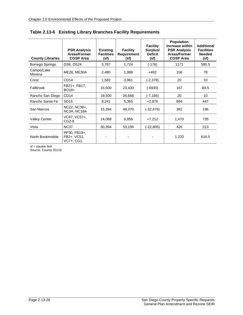
Chapter 2.0 Environmental Effects of the Proposed Project
Page 2.13-28 San Diego County Property Specific Requests General Plan Amendment and Rezone SEIR
Table 2.13-6 Existing Library Branches Facility Requirements
County Libraries
PSR Analysis Areas/Former
CGSP Area
Existing Facilities
(sf)
Facility Requirement
(sf)
Facility Surplus/ Deficit
(sf)
Population Increase within PSR Analysis Areas/Former
CGSP Area
Additional Facilities Needed
(sf)
Borrego Springs DS8, DS24 3,787 1,724 (-176) 1171 585.5
Campo/Lake Morena
ME26, ME30A 2,480 1,988 +492 156 78
Crest CD14 1,583 3,961 (-2,378) 20 10
Fallbrook FB21+, FB17, BO18+
16,500 23,430 (-6930) 167 83.5
Rancho San Diego CD14 19,500 26,666 (-7,166) 20 10
Rancho Santa Fe SD15 8,241 5,365 +2,876 894 447
San Marcos NC22, NC38+, NC3A, NC18A
15,394 48,070 (-32,676) 392 196
Valley Center VC67, VC57+, CG2-8
14,068 6,856 +7,212 1,470 735
Vista NC37 30,394 53,199 (-22,805) 426 213
North Bookmobile PP30, FB19+, FB2+, VC51, VC7+, CG1
- - - 1,233 616.5
sf = square feet Source: County 2011b

2.13 Public Services
San Diego County Property Specific Requests General Plan Amendment and Rezone SEIR
Page 2.13-29
Table 2.13-7 Required Fire Travel Time Standards for the Proposed PSR Analysis Areas and Former CGSP Area
PSR Analysis Areas/Former
CGSP Subareas # of Parcels Proposed Land Use
Designation
Required Travel Time per Proposed Project Designation
(Minutes) Significant (Yes/No)
BO18+ 120 SR-4 10 Y
CD14 10 SR-2 RL-20
10 20
N
DS8 3 VR-4.3 5 N
DS24 2 SR-1 5 Y
FB2+ 23 SR-4 RL-20
10 20
Y
FB17 6 SR-1 SR-2
5 10
Y
FB19+ 61 SR-10 20 N
FB21+ 52 SR-10 20 Y
ME26 15 SR-10 20 N
ME30A 1 SR-4 RL-40
10 >20
N
NC3A 48 SR-10 20 N
NC18A 5 SR-1 SR-2
5 10
Y
NC22 17 SR-1 SR-10
5 20
Y
NC37 15 SR-4 10 Y
NC38+ 8 SR-1 5 Y
PP30 11 SR-2 RL-40
10 >20
N
SD15 1 VR-10.9, SR-0.5, GC 5 Y
VC7+ 233 SR-2 10 Y
VC51 14 SR-4 10 Y
VC57+ 217 SR-2 10 N
VC67 6 I-2 10 N
CG1 - SR-10 20 N
CG2 - SR-4 10 N
CG3 - SR-2 10 N
CG4 - SR-2 10 N
CG5 - SR-2 10 N
CG6 - RC (within Semi-
Rural Regional Category), SR-10
20 N
CG7 - SR-10 20 N
CG8 - SR-10 20 N
Source: County 2017

Chapter 2.0 Environmental Effects of the Proposed Project
Page 2.13-30 San Diego County Property Specific Requests General Plan Amendment and Rezone SEIR
Table 2.13-8 Population and Housing Increase
CPA/Subregion PSR Analysis Area/Former
CGSP Subareas Increase in
Dwelling Units Average Persons
per Household
Increase in Population
Bonsall BO18+ (67 DU increase) 67 2.77 186
CG1,6,7,8 (7 DU increase) 7 2.77 19
Crest-Dehesa CD14 7 2.85 20
Desert DS8 389 2.16 840
DS24 153 2.16 331
Fallbrook
FB2+ 16 2.89 47
FB17 33 2.89 96
FB19+ 1 2.89 3
FB21+ 7 2.89 21
Mountain Empire ME26 26 2.82 74
ME30A 29 2.82 82
North County Metro
NC3A 11 2.79 31
NC18A 34 2.79 95
NC22 52 2.79 146
NC37 12 2.79 34
NC38+ (38 DU increase) 38 2.79 106
CG5 (5 DU increase) 5 2.79 14
Pala-Pauma PP30 122 3.32 406
San Dieguito SD15 301 2.97 894
Valley Center
VC7+ 253 2.92 739
VC51 13 2.92 38
VC57+ 231 2.92 675
VC67 (0 DU increase) - 2.92 0
CGSP 2,3,4 (19 DU increase) 19 2.92 56
DU = dwelling unit Source: SANDAG 2017d
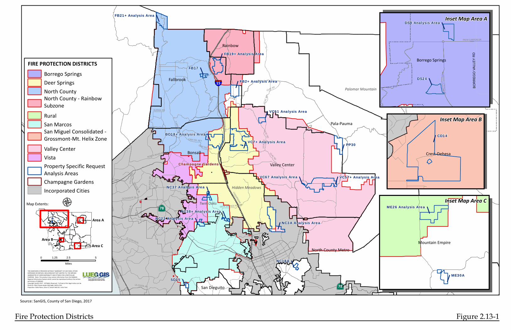
§̈¦
·|}ÿ
§̈¦
·|}ÿ
·|}ÿ
·|}ÿ
PP30
VC51 Analysis Area
NC3A Analysis Area
FB2+ Analysis Area
VC57+ Analysis Area
FB19+ Analysis Area
Champagne Gardens
SD15
FB17
NC18A
VC67 Analysis AreaNC37 Analysis Area
NC22 Analysis Area
North MountainPendleton-De Luz
Pala-Pauma
Valley Center
Fallbrook
Bonsall
Ramona
Rainbow
North County Metro
San DieguitoLA COSTA AV
CANFIELD RD
CHAMPAGNE BL
OCEANSIDE BL
EAST GRADE RD
NORTH RIVER RD
LILAC RD
S MISSION RD
CARLSBAD BL
OLD HIGHWAY 395
COLLE
GE BL
MISSION RD
EL CAM REAL
CAM DEL REY
MELRO
SE DR
DEER SPRINGS RD
N CENTRE CITY PY
BURMA RD
COLLE
GE BL
COLLEGE BL
EAST GRADE RD
LILAC RD
CANFIELD RD
LILAC
RDLILA
C RD
CAM DEL REY
EL CAM REAL
LILAC RD
5
76
78
76
15
78
Palomar Mountain
Twin Oaks
Hidden Meadows
VC7+ Analysis Area
NC38+ Analysis Area
FB21+ Analysis Area
BO18+ Analysis Area
FIRE PROTECTION DISTRICTSBorrego SpringsDeer SpringsNorth CountyNorth County - RainbowSubzoneRuralSan MarcosSan Miguel Consolidated - Grossmont-Mt. Helix ZoneValley CenterVistaProperty Specific RequestAnalysis AreasChampagne GardensIncorporated Cities
THIS MAP/DATA IS PROVIDED WITHOUT WARRANTY OF ANY KIND, EITHEREXPRESSED OR IMPLIED, INCLUDING BUT NOT LIMITED TO, THE IMPLIEDWARRANTIES OF MERCHANTABILITY AND FITNESS FOR A PARTICULARPURPOSE. Note: This product may contain information from the SANDAGRegional Information System which cannot be reproduced without the writtenpermission of SANDAG.Copyright SanGIS 2017 - All Rights Reserved. Full text of this legal notice can befound at: http://www.sangis.org/Legal_Notice.htmProjection: State Plane, Zone VI, Datum NAD 83. Units Feet.
0 2.5 51.25
Miles
Á
DS24
DS8 Analysis Area
BO
RR
EG
O V
ALL
EY
RD
PALM CANYON DR
BORREGO SPRINGS RDBorrego Springs
Inset Map Area A
Source: SanGIS, County of San Diego, 2017
Fire Protection Districts Figure 2.13-1
ME30A
ME26 Analysis Area
Mountain Empire
Inset Map Area C
CD14
Crest-Dehesa
Inset Map Area B
Map Extents:
Area A
Area BArea C

§̈¦
·|}ÿ
§̈¦
·|}ÿ
·|}ÿ
·|}ÿ
#*
#* #*
#*
#*
#*
#*#*
#*
#*
#*
#*
#*
#*
#*
#*
#*
#*
#*
#*
#*
#*
#*
#*
#*
#*
")
")
#*
#*
#*
#*
#*
#*
#*
!(
!(
!(
#*
#*
#*
")
#*
!(
#*#*
#*
!(
#*
!(
#*
#*#*
#*
#*
#*#*
#*
#*
#*
#*
#*
#*
#*
#*
#*
!(
!(
!(
!(
#*
!(
!(
#*
!(
#*
#*
")
")
PP30
VC51 Analysis Area
NC3A Analysis Area
FB2+ Analysis Area
VC57+ Analysis Area
FB19+ Analysis Area
Champagne Gardens
SD15
FB17
NC18A
VC67 Analysis AreaNC37 Analysis Area
NC22 Analysis Area
North MountainPendleton-De Luz
Pala-Pauma
Valley Center
Fallbrook
Bonsall
Ramona
Rainbow
North County Metro
San DieguitoLA COSTA AV
CANFIELD RD
CHAMPAGNE BL
OCEANSIDE BL
EAST GRADE RD
NORTH RIVER RD
LILAC RD
S MISSION RD
CARLSBAD BL
OLD HIGHWAY 395
COLLE
GE BL
MISSION RD
EL CAM REAL
CAM DEL REY
MELRO
SE DR
DEER SPRINGS RD
N CENTRE CITY PY
BURMA RD
COLLE
GE BL
COLLEGE BL
EAST GRADE RD
LILAC RD
CANFIELD RD
LILAC
RDLILA
C RD
CAM DEL REY
EL CAM REAL
LILAC RD
5
76
78
76
15
78
Palomar Mountain
Twin Oaks
Hidden Meadows
VC7+ Analysis Area
NC38+ Analysis Area
FB21+ Analysis Area
BO18+ Analysis Area
FIRE STATIONS#* Full-Time!( Part-Time") Seasonal
0 to 5 Minutes Travel Area5 to 10 Minutes Travel Area10 to 20 Minutes Travel AreaProperty Specific RequestAnalysis AreasChampagne GardensIncorporated Cities
THIS MAP/DATA IS PROVIDED WITHOUT WARRANTY OF ANY KIND, EITHEREXPRESSED OR IMPLIED, INCLUDING BUT NOT LIMITED TO, THE IMPLIEDWARRANTIES OF MERCHANTABILITY AND FITNESS FOR A PARTICULARPURPOSE. Note: This product may contain information from the SANDAGRegional Information System which cannot be reproduced without the writtenpermission of SANDAG.Copyright SanGIS 2012 - All Rights Reserved. Full text of this legal notice can befound at: http://www.sangis.org/Legal_Notice.htmProjection: State Plane, Zone VI, Datum NAD 83. Units Feet.
0 2.5 51.25
Miles
Á
#*
DS24
DS8 Analysis Area
BO
RR
EG
O V
ALL
EY
RD
PALM CANYON DR
BORREGO SPRINGS RDBorrego Springs
Inset Map Area A
Source: SanGIS, County of San Diego, 2017
Fire Response Times Figure 2.13-2
#*
!(
!(
ME30A
ME26 Analysis Area
Mountain Empire
Inset Map Area C
CD14
Crest-Dehesa
Inset Map Area B
Map Extents:
Area A
Area BArea C

§̈¦
·|}ÿ
§̈¦
·|}ÿ
·|}ÿ
·|}ÿ
PP30VC7+ Analysis Area
VC51 Analysis Area
NC3A Analysis Area
FB2+ Analysis Area
VC57+ Analysis Area
FB19+ Analysis Area
Champagne Gardens
SD15
FB17
NC18A
NC22 Analysis Area
FB21+ Analysis Area
BO18+ Analysis Area
North MountainPendleton-De Luz
Pala-Pauma
Valley Center
Fallbrook
Bonsall
Ramona
Rainbow
North County Metro
San DieguitoLA COSTA AV
CANFIELD RD
CHAMPAGNE BL
OCEANSIDE BL
EAST GRADE RD
NORTH RIVER RD
LILAC R
D
CARLSBAD BL
OLD HIGHWAY 395
COLLE
GE BL
MISSION RD
EL CAM REAL
CAM DEL REYME
LROSE
DR
N CENTRE CITY PY
BURMA RD
COLLEGE BL
COLLE
GE BL
CANFIELD RD
OLD HIG
HWAY
395
LILAC RDEL CAM REAL
5
76
78
76
15
78
Palomar Mountain
Twin OaksHidden Meadows
VC67 Analysis AreaNC37 Analysis Area
NC38+ Analysis Area
DS24
DS8 Analysis Area
BO
RR
EG
O V
ALL
EY
RD
BORREGO SPRINGS RDBorrego Springs
Inset Map Area A
Source: SanGIS, County of San Diego, 2017
San Diego Sheriff Service Areas Figure 2.13-3
ME30A
ME26 Analysis Area
Mountain Empire
Inset Map Area C
CD14
Inset Map Area B
Crest-Dehesa
THIS MAP/DATA IS PROVIDED WITHOUT WARRANTY OF ANY KIND, EITHEREXPRESSED OR IMPLIED, INCLUDING BUT NOT LIMITED TO, THE IMPLIEDWARRANTIES OF MERCHANTABILITY AND FITNESS FOR A PARTICULARPURPOSE. Note: This product may contain information from the SANDAGRegional Information System which cannot be reproduced without the writtenpermission of SANDAG.Copyright SanGIS 2017 - All Rights Reserved. Full text of this legal notice can befound at: http://www.sangis.org/Legal_Notice.htmProjection: State Plane, Zone VI, Datum NAD 83. Units Feet.Path: P:\gp2020\20160701_PSR_EIR_MAPS_TABLES\MXDs\PSR_Sheriff_Service_Areas.mxdCounty of San Diego, LUEG GIS 7/17/2017
0 2.5 51.25
Miles
ÁMap Extents:
Area A
Area BArea C
ALPINECAMPOCAMPO (LITTLE)FALLBROOKLAKESIDENORTH COASTAL PALAPINE VALLEYRANCHITARANCHO SAN DIEGORINCONSAN MARCOSSAN PASQUALVALLEY CENTERVISTAProperty Specific RequestAnalysis AreasChampagne GardensIncorporated Cities
SAN DIEGO SHERIFF SERVICE AREAS

§̈¦
·|}ÿ
§̈¦
·|}ÿ
·|}ÿ
·|}ÿ
PP30
VC51 Analysis Area
NC3A Analysis Area
FB2+ Analysis Area
VC57+ Analysis Area
FB19+ Analysis Area
Champagne Gardens
SD15
FB17
NC18A
VC67 Analysis AreaNC37 Analysis Area
NC22 Analysis Area
North MountainPendleton-De Luz
Pala-Pauma
Valley Center
Fallbrook
Bonsall
Ramona
Rainbow
North County Metro
San DieguitoLA COSTA AV
CANFIELD RD
CHAMPAGNE BL
OCEANSIDE BL
EAST GRADE RD
NORTH RIVER RD
LILAC RD
S MISSION RD
CARLSBAD BL
OLD HIGHWAY 395
COLLE
GE BL
MISSION RD
EL CAM REAL
CAM DEL REY
MELRO
SE DR
DEER SPRINGS RD
N CENTRE CITY PY
BURMA RD
COLLE
GE BL
COLLEGE BL
EAST GRADE RD
LILAC RD
CANFIELD RD
LILAC
RDLILA
C RD
CAM DEL REY
EL CAM REAL
LILAC RD
5
76
78
76
15
78
Palomar Mountain
Twin Oaks
Hidden Meadows
VC7+ Analysis Area
NC38+ Analysis Area
FB21+ Analysis Area
BO18+ Analysis Area
ELEMENTARY SCHOOL DISTRICTSOther DistrictsCajon Valley UnionEncinitas UnionEscondido UnionFallbrook UnionVallecitos UnionProperty Specific RequestAnalysis AreasChampagne GardensIncorporated Cities
THIS MAP/DATA IS PROVIDED WITHOUT WARRANTY OF ANY KIND, EITHEREXPRESSED OR IMPLIED, INCLUDING BUT NOT LIMITED TO, THE IMPLIEDWARRANTIES OF MERCHANTABILITY AND FITNESS FOR A PARTICULARPURPOSE. Note: This product may contain information from the SANDAGRegional Information System which cannot be reproduced without the writtenpermission of SANDAG.Copyright SanGIS 2017 - All Rights Reserved. Full text of this legal notice can befound at: http://www.sangis.org/Legal_Notice.htmProjection: State Plane, Zone VI, Datum NAD 83. Units Feet.
0 2.5 51.25
Miles
Á
DS24
DS8 Analysis Area
BO
RR
EG
O V
ALL
EY
RD
PALM CANYON DR
BORREGO SPRINGS RDBorrego Springs
Inset Map Area A
Source: SanGIS, County of San Diego, 2017
Elementary School Districts Figure 2.13-4
ME30A
ME26 Analysis Area
Mountain Empire
Inset Map Area C
CD14
Crest-Dehesa
Inset Map Area B
Map Extents:
Area A
Area BArea C

§̈¦
·|}ÿ
§̈¦
·|}ÿ
·|}ÿ
·|}ÿ
PP30
VC51 Analysis Area
NC3A Analysis Area
FB2+ Analysis Area
VC57+ Analysis Area
FB19+ Analysis Area
Champagne Gardens
SD15
FB17
NC18A
VC67 Analysis AreaNC37 Analysis Area
NC22 Analysis Area
North MountainPendleton-De Luz
Pala-Pauma
Valley Center
Fallbrook
Bonsall
Ramona
Rainbow
North County Metro
San DieguitoLA COSTA AV
CANFIELD RD
CHAMPAGNE BL
OCEANSIDE BL
EAST GRADE RD
NORTH RIVER RD
LILAC RD
S MISSION RD
CARLSBAD BL
OLD HIGHWAY 395
COLLE
GE BL
MISSION RD
EL CAM REAL
CAM DEL REY
MELRO
SE DR
DEER SPRINGS RD
N CENTRE CITY PY
BURMA RD
COLLE
GE BL
COLLEGE BL
EAST GRADE RD
LILAC RD
CANFIELD RD
LILAC
RDLILA
C RD
CAM DEL REY
EL CAM REAL
LILAC RD
5
76
78
76
15
78
Palomar Mountain
Twin Oaks
Hidden Meadows
VC7+ Analysis Area
NC38+ Analysis Area
FB21+ Analysis Area
BO18+ Analysis Area
HIGH SCHOOL DISTRICTSOther DistrictsEscondido UnionFallbrook UnionGrossmont UnionSan Dieguito UnionProperty Specific RequestAnalysis AreasChampagne GardensIncorporated Cities
THIS MAP/DATA IS PROVIDED WITHOUT WARRANTY OF ANY KIND, EITHEREXPRESSED OR IMPLIED, INCLUDING BUT NOT LIMITED TO, THE IMPLIEDWARRANTIES OF MERCHANTABILITY AND FITNESS FOR A PARTICULARPURPOSE. Note: This product may contain information from the SANDAGRegional Information System which cannot be reproduced without the writtenpermission of SANDAG.Copyright SanGIS 2017 - All Rights Reserved. Full text of this legal notice can befound at: http://www.sangis.org/Legal_Notice.htmProjection: State Plane, Zone VI, Datum NAD 83. Units Feet.
0 2.5 51.25
Miles
Á
DS24
DS8 Analysis Area
BO
RR
EG
O V
ALL
EY
RD
PALM CANYON DR
BORREGO SPRINGS RDBorrego Springs
Inset Map Area A
Source: SanGIS, County of San Diego, 2017
High School Districts Figure 2.13-5
ME30A
ME26 Analysis Area
Mountain Empire
Inset Map Area C
CD14
Crest-Dehesa
Inset Map Area B
Map Extents:
Area A
Area BArea C

§̈¦
·|}ÿ
§̈¦
·|}ÿ
·|}ÿ
·|}ÿ
PP30
VC51 Analysis Area
NC3A Analysis Area
FB2+ Analysis Area
VC57+ Analysis Area
FB19+ Analysis Area
Champagne Gardens
SD15
FB17
NC18A
VC67 Analysis AreaNC37 Analysis Area
NC22 Analysis Area
North MountainPendleton-De Luz
Pala-Pauma
Valley Center
Fallbrook
Bonsall
Ramona
Rainbow
North County Metro
San DieguitoLA COSTA AV
CANFIELD RD
CHAMPAGNE BL
OCEANSIDE BL
EAST GRADE RD
NORTH RIVER RD
LILAC RD
S MISSION RD
CARLSBAD BL
OLD HIGHWAY 395
COLLE
GE BL
MISSION RD
EL CAM REAL
CAM DEL REY
MELRO
SE DR
DEER SPRINGS RD
N CENTRE CITY PY
BURMA RD
COLLE
GE BL
COLLEGE BL
EAST GRADE RD
LILAC RD
CANFIELD RD
LILAC
RDLILA
C RD
CAM DEL REY
EL CAM REAL
LILAC RD
5
76
78
76
15
78
Palomar Mountain
Twin Oaks
Hidden Meadows
VC7+ Analysis Area
NC38+ Analysis Area
FB21+ Analysis Area
BO18+ Analysis Area
UNIFIED SCHOOL DISTRICTSOther DistrictsBonsallBorrego SpringsMountain EmpireSan MarcosValley CenterVistaProperty Specific RequestAnalysis AreasChampagne GardensIncorporated Cities
THIS MAP/DATA IS PROVIDED WITHOUT WARRANTY OF ANY KIND, EITHEREXPRESSED OR IMPLIED, INCLUDING BUT NOT LIMITED TO, THE IMPLIEDWARRANTIES OF MERCHANTABILITY AND FITNESS FOR A PARTICULARPURPOSE. Note: This product may contain information from the SANDAGRegional Information System which cannot be reproduced without the writtenpermission of SANDAG.Copyright SanGIS 2017 - All Rights Reserved. Full text of this legal notice can befound at: http://www.sangis.org/Legal_Notice.htmProjection: State Plane, Zone VI, Datum NAD 83. Units Feet.
0 2.5 51.25
Miles
Á
DS24
DS8 Analysis Area
BO
RR
EG
O V
ALL
EY
RD
PALM CANYON DR
BORREGO SPRINGS RDBorrego Springs
Inset Map Area A
Source: SanGIS, County of San Diego, 2017
Unified School Districts Figure 2.13-6
ME30A
ME26 Analysis Area
Mountain Empire
Inset Map Area C
CD14
Crest-Dehesa
Inset Map Area B
Map Extents:
Area A
Area BArea C

§̈¦
·|}ÿ
§̈¦
·|}ÿ
·|}ÿ
·|}ÿ
PP30
VC51 Analysis Area
NC3A Analysis Area
FB2+ Analysis Area
VC57+ Analysis Area
FB19+ Analysis Area
Champagne Gardens
SD15
FB17
NC18A
VC67 Analysis AreaNC37 Analysis Area
NC22 Analysis Area
North MountainPendleton-De Luz
Pala-Pauma
Valley Center
Fallbrook
Bonsall
Ramona
Rainbow
North County Metro
San DieguitoLA COSTA AV
CANFIELD RD
CHAMPAGNE BL
OCEANSIDE BL
EAST GRADE RD
NORTH RIVER RD
LILAC RD
S MISSION RD
CARLSBAD BL
OLD HIGHWAY 395
COLLE
GE BL
MISSION RD
EL CAM REAL
CAM DEL REY
MELRO
SE DR
DEER SPRINGS RD
N CENTRE CITY PY
BURMA RD
COLLE
GE BL
COLLEGE BL
EAST GRADE RD
LILAC RD
CANFIELD RD
LILAC
RDLILA
C RD
CAM DEL REY
EL CAM REAL
LILAC RD
5
76
78
76
15
78
Palomar Mountain
Twin Oaks
Hidden Meadows
VC7+ Analysis Area
NC38+ Analysis Area
FB21+ Analysis Area
BO18+ Analysis Area
LIBRARY SERVICE AREASOther AreasBorrego SpringsCampoCrestFallbrookNorth BookmobileRancho San DiegoRancho Santa FeSan MarcosValley CenterVistaProperty Specific RequestAnalysis AreasChampagne GardensIncorporated Cities
THIS MAP/DATA IS PROVIDED WITHOUT WARRANTY OF ANY KIND, EITHEREXPRESSED OR IMPLIED, INCLUDING BUT NOT LIMITED TO, THE IMPLIEDWARRANTIES OF MERCHANTABILITY AND FITNESS FOR A PARTICULARPURPOSE. Note: This product may contain information from the SANDAGRegional Information System which cannot be reproduced without the writtenpermission of SANDAG.Copyright SanGIS 2017 - All Rights Reserved. Full text of this legal notice can befound at: http://www.sangis.org/Legal_Notice.htmProjection: State Plane, Zone VI, Datum NAD 83. Units Feet.
0 2.5 51.25
Miles
Á
DS24
DS8 Analysis Area
BO
RR
EG
O V
ALL
EY
RD
PALM CANYON DR
BORREGO SPRINGS RDBorrego Springs
Inset Map Area A
Source: SanGIS, County of San Diego, 2017
Library Service Areas Figure 2.13-7
ME30A
ME26 Analysis Area
Mountain Empire
Inset Map Area C
CD14
Crest-Dehesa
Inset Map Area B
Map Extents:
Area A
Area BArea C

Chapter 2.0 Environmental Effects of the Proposed Project
Page 2.13-38 San Diego County Property Specific Requests General Plan Amendment and Rezone SEIR
This page intentionally left blank.


