
21.04 OBJECTIVES - STRATEGIES - IMPLEMENTATION
31
GREATER DANDENONG PLANNING SCHEME MUNICIPAL STRATEGIC STATEMENT - CLAUSE 21.04 PAGE 1 OF 31 21.04 OBJECTIVES - STRATEGIES - IMPLEMENTATION The following elements characterise patterns of land use and development across the municipality: Residential. Industrial. Business. Non-urban. Heritage and urban design. Open space and recreation. Traffic and transport. Each element is examined in terms of: Overview - Provides a context for consideration of the element. Objectives - What Council wants to achieve with regard to the element. Strategies - How Council will achieve the stated objectives. Implementation - Means of achieving the strategies. All objectives, strategies and means of implementation must be read in context with those contained in the various other land-use and development elements and the other sections of this scheme. Having regard to both the Corporate Plan and other influencing factors, the following issues are particularly addressed in this section: The industrial image of Greater Dandenong. The need for more diverse housing and employment opportunities. Giving expression to the cultural and ethnic diversity of the community. Protecting the municipality’s strong industrial base. Promoting and further developing the Dandenong CAD as Melbourne’s second largest retail and commercial centre. Protecting the natural environment and flood plains. Protecting assets of regional and metropolitan significance such as the Industrial 2 Precinct, the Eastern Treatment Plant, the Lyndhurst landfill, the Sandown Racecourse, Motor Racing Circuit and Greyhound Racing Track and the Springvale Crematorium. 21.04-1 Residential Overview Greater Dandenong has a rapidly aging and extremely diverse population, with 137 different nationalities represented, of which thirty-eight percent are from non-English speaking backgrounds. Housing provision has tended to be uniform, but as the municipality changes and accommodates an older population greater diversity in housing will be required. Diversity will be expressed in both functional and aesthetic terms and is important in developing a coherent sense of community in the municipality. Keysborough South Keysborough South is an area of strategic significance for residential development. This emerging residential area will bring a challenge in managing the urban/non urban transition. This emerging area will bring a challenge in managing the urban/non-urban transition. Residential development in this area needs to be based on Council’s “green vision” – the public realm having the primary role in delivering a range of beneficial 06/08/2009 C80 06/08/2009 C80
Transcript of 21.04 OBJECTIVES - STRATEGIES - IMPLEMENTATION

GREATER DANDENONG PLANNING SCHEME
MUNICIPAL STRATEGIC STATEMENT - CLAUSE 21.04 PAGE 1 OF 31
21.04 OBJECTIVES - STRATEGIES - IMPLEMENTATION
The following elements characterise patterns of land use and development across the municipality:
Residential.
Industrial.
Business.
Non-urban.
Heritage and urban design.
Open space and recreation.
Traffic and transport.
Each element is examined in terms of:
Overview - Provides a context for consideration of the element.
Objectives - What Council wants to achieve with regard to the element.
Strategies - How Council will achieve the stated objectives.
Implementation - Means of achieving the strategies.
All objectives, strategies and means of implementation must be read in context with those contained in the various other land-use and development elements and the other sections of this scheme.
Having regard to both the Corporate Plan and other influencing factors, the following issues are particularly addressed in this section:
The industrial image of Greater Dandenong.
The need for more diverse housing and employment opportunities.
Giving expression to the cultural and ethnic diversity of the community.
Protecting the municipality’s strong industrial base.
Promoting and further developing the Dandenong CAD as Melbourne’s second largest retail and commercial centre.
Protecting the natural environment and flood plains.
Protecting assets of regional and metropolitan significance such as the Industrial 2 Precinct, the Eastern Treatment Plant, the Lyndhurst landfill, the Sandown Racecourse, Motor Racing Circuit and Greyhound Racing Track and the Springvale Crematorium.
21.04-1 Residential
Overview
Greater Dandenong has a rapidly aging and extremely diverse population, with 137 different nationalities represented, of which thirty-eight percent are from non-English speaking backgrounds. Housing provision has tended to be uniform, but as the municipality changes and accommodates an older population greater diversity in housing will be required. Diversity will be expressed in both functional and aesthetic terms and is important in developing a coherent sense of community in the municipality.
Keysborough South
Keysborough South is an area of strategic significance for residential development. This emerging residential area will bring a challenge in managing the urban/non urban transition. This emerging area will bring a challenge in managing the urban/non-urban transition. Residential development in this area needs to be based on Council’s “green vision” – the public realm having the primary role in delivering a range of beneficial
06/08/2009 C80
06/08/2009 C80

GREATER DANDENONG PLANNING SCHEME
environmental, landscape and recreation outcomes with more intensive forms of development being supported in private space within the green environment.
Dandenong Railway Precinct
A significant infill redevelopment opportunity is available on land known as the Dandenong Railway Precinct, which comprises the former Dandenong Saleyards and the Council depot and VicTrack land. A concept for development of the Dandenong Railway Precinct is identified in the incorporated document: Dandenong Railway Precinct Comprehensive Development Plan, Tract Consultants, August 2003. This concept is based on the objectives to redevelop the land for innovative residential, mixed use and employment development which will be based on new urbanist principles, fully integrated with the Dandenong CAD and Transport Interchange. It is envisaged that approximately 3500 people will be accommodated within the development over the next ten years in a variety of housing styles and densities. The Comprehensive Development Plan includes the potential for higher density residential and mixed use development near the rail line, with more conventional residential development to the south west, some lighter industrial activity on its eastern boundary and some medium density housing along the Dandenong Creek.
Objectives
What we want to achieve is:
To provide access to a range and quality of housing opportunities which meet the needs of the population.
To provide residential environments with a neighbourhood focus that enhances residential amenity, accessibility, safety, enjoyment and quality of life of the community.
To encourage a diversity of housing stock which reinforces and enhances suburbs with distinctive characteristics which reflect and contribute to community identity.
To provide for the orderly development of new residential areas.
To establish a vision for the future of the Keysborough South area that recognizes and enhances the area’s function.
To facilitate the redevelopment of the Dandenong Railway Precinct.
To encourage the redevelopment of the Dandenong Railway Precinct for innovative residential and mixed use development which optimises the site’s close proximity and access to the Dandenong Railway Station and transport facilities.
To encourage transit orientated development.
To encourage new housing or alternative land uses to be sited and designed to provide appropriate acoustic and amenity protection to nearby industry.
Strategies
These objectives will be achieved by:
Actively encouraging medium-density housing generally, and more particularly in proximity to shops, public transport, community and cultural services, commercial centres and open space networks.
Improving residential amenity by restricting undesirable through-traffic by working with other government agencies to:
Develop Local Area Traffic Management Plans.
Construct proposed major transport links.
Developing incentive schemes to encourage the upgrading of owner-occupied and rental housing in proximity to the Dandenong CAD.
Requiring medium-density developments to be site and locality responsive and to respect neighbourhood character.
MUNICIPAL STRATEGIC STATEMENT - CLAUSE 21.04 PAGE 2 OF 31

GREATER DANDENONG PLANNING SCHEME
Encouraging integrated development proposals addressing both the design of development and future subdivision.
Encouraging conversion of vacant upper floors of shops and offices for housing, particularly in the Dandenong CAD.
Providing appropriate controls for areas on the periphery of the Dandenong CAD, Springvale Shopping Centre and Noble Park Shopping Centre which are suitable for higher-density housing, making optimum use of facilities and services available. These areas should be defined by recognised physical boundaries, have good access to facilities and not threaten existing urban character. High density housing is most appropriate in areas adjacent to the Dandenong CAD, while other areas further away from the Dandenong CAD and around other major retail centres are appropriate for medium-density housing.
Identifying land with drainage and flood constraints and ensuring development responds to these constraints.
Providing a framework for the development of land in the Keysborough South area complementary to the Green Space vision outlined in Clause 21.04-04 and to the urban areas to the north.
Recognising existing use rights of agricultural and dog uses and managing the residential process to protect their continued operation and the amenity of the sensitive uses.
Providing for a mix of residential and commercial uses in the Dandenong Railway Precinct.
Providing integrated residential and employment opportunities at the Dandenong Railway Precinct.
Encouraging master plans to be prepared for institutional uses within Keysborough to guide the future land use and development of the sites.
Implementation
These strategies will be implemented by:
Policy and exercise of discretion
Applying the Keysborough South Local Planning Policy at Clause 22.06 to provide for an orderly and structured framework to guide future development of this new residential area.
Using the “Urban design in the Residential 2 Zone” policy at Clause 22.05 to emphasise the importance of design and landscaping in determining permit applications in the Residential 2 Zone.
Encouraging opportunities for under-utilised local neighbourhood shopping centres to be redeveloped for other purposes such as medium-density housing.
Encouraging subdivisions that provide varying lot sizes in order to cater for a range of residential uses.
Implementing the vision and philosophy identified in the Dandenong Railway Precinct Comprehensive Development Plan, Tract Consultants, August 2003.
The development of institutional uses, other than through minor applications, in the Keysborough area to be managed in accordance with master plans for future development.
Zones and overlays
Applying the Residential 2 Zone around the activity centres of Springvale, Dandenong and Noble Park and the Residential 1 zone to all other established residential areas.
Applying the Special Building Overlay to land affected by overland flows in storm events that exceed the capacity of underground drainage systems.
MUNICIPAL STRATEGIC STATEMENT - CLAUSE 21.04 PAGE 3 OF 31

GREATER DANDENONG PLANNING SCHEME
Including land identified for urban conversion situated north of the Keysborough Golf Club and west of Chapel Road in a Residential 1 zone.
Applying a Development Plan Overlay to all new residential areas to provide for orderly and comprehensive structure planning.
Applying a Design and Development Overlay in the Keysborough South area to require a mandatory five star VICHERS Energy Rating.
Applying the Comprehensive Development Zone over the former Dandenong Saleyards site to provide for an integrated mix of residential and employment activities.
Further strategic work
Developing a local policy on the processing of applications for multi-dwelling developments.
Developing a methodology and principles for the preparation of precinct plans and design criteria to guide the development of Residential 2 zoned land.
Developing precinct plans with a clear vision and design criteria for the Dandenong Residential 2 zoned area.
Developing an Urban Renewal Strategy for the land bounded by Greaves Street, Carroll Lane, the Railway line, Cheltenham Road, Hammond Road and the Dandenong Creek.
Other actions
Reference documents
City of Greater Dandenong: Shop Top Housing Feasibility Study (Urban Consulting Group 1996)
South East Non-Urban Study (Spiller Gibbons Swan Pty Ltd and TBA Planners Pty Ltd 1997)
Strategic Review of the Keysborough/Wetlands Area and Framework Plan (GHD Planning 1998)
Dandenong Railway Precinct Comprehensive Development Plan (Tract Consultants Pty Ltd August 2003)
Design Controls, Dandenong Railway Precinct Redevelopment (dKO 2003)
MUNICIPAL STRATEGIC STATEMENT - CLAUSE 21.04 PAGE 4 OF 31

GREATER DANDENONG PLANNING SCHEME
MUNICIPAL STRATEGIC STATEMENT - CLAUSE 21.04 PAGE 5 OF 31
kilometres
Legend
0 1 2
N
Cor
riga
n R
d
Ham
mon
d R
d
Gla
dsto
ne
Rd
Wor
sley
Rd
Dan
deno
ng C
k
Dandenong C
k
Spr
ingv
ale
Rd
Cheltenham Rd
Cha
ndle
r R
d
Police Rd
Princes Hwy
Wes
tall
Rd
Spr
ingv
ale
Rd
Jack
sons
Rd
Greens Rd
Thompsons Rd
Dan
deno
ng V
alle
y H
wy
Wes
tern
Por
t Hw
y
Princes Hwy
Heatherton Rd
Stu
d R
d
Monash Fwy
Urban/Non UrbanBoundary
Medium DensityEncouraged
Lewis StShops
Erica StShops
Sandown ParkStation
Goodwood Dve
View RdCouncil Depot
Gove StShops
Buckley StOld Primary School
Keysborough SouthFuture Green Vision Residential
Springvale PlazaShops
RedevelopmentSites
Thomas St
Outlook DveShops
Greaves StOld Industrial
Former DandenongStockyards
Kirkham RdMelbourne Water Land
Keysborough SouthResidential Green Vision
Residential Element
GREATER DANDENONG PLANNING SCHEME
MUNICIPAL STRATEGIC STATEMENT - CLAUSE 21.04 PAGE 6 OF 31
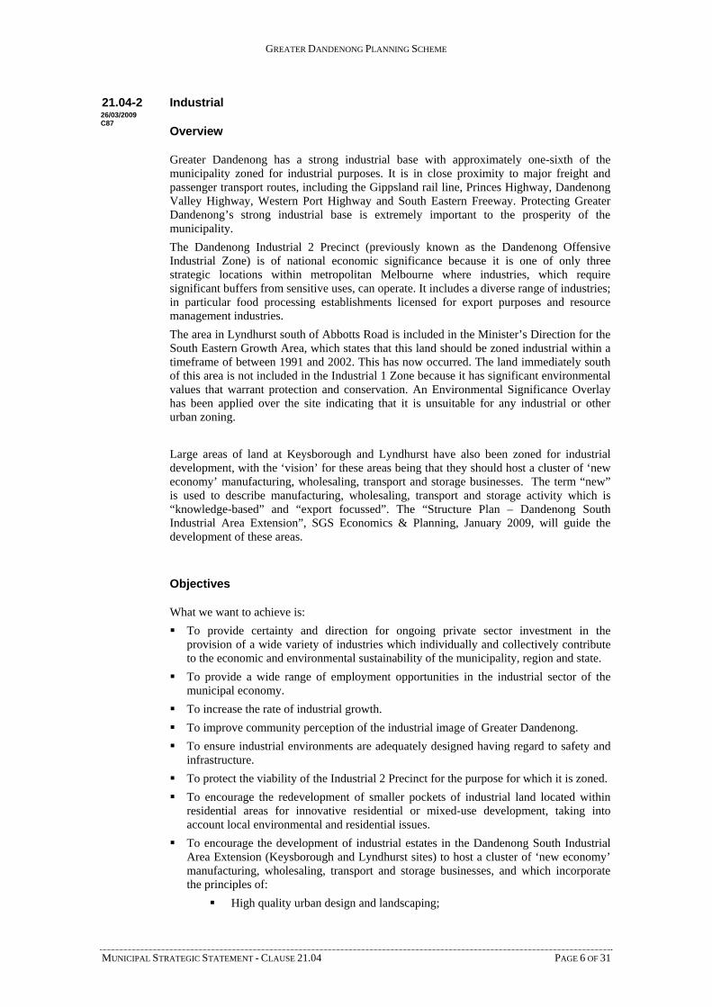
21.04-2 Industrial
Overview
Greater Dandenong has a strong industrial base with approximately one-sixth of the municipality zoned for industrial purposes. It is in close proximity to major freight and passenger transport routes, including the Gippsland rail line, Princes Highway, Dandenong Valley Highway, Western Port Highway and South Eastern Freeway. Protecting Greater Dandenong’s strong industrial base is extremely important to the prosperity of the municipality.
The Dandenong Industrial 2 Precinct (previously known as the Dandenong Offensive Industrial Zone) is of national economic significance because it is one of only three strategic locations within metropolitan Melbourne where industries, which require significant buffers from sensitive uses, can operate. It includes a diverse range of industries; in particular food processing establishments licensed for export purposes and resource management industries.
The area in Lyndhurst south of Abbotts Road is included in the Minister’s Direction for the South Eastern Growth Area, which states that this land should be zoned industrial within a timeframe of between 1991 and 2002. This has now occurred. The land immediately south of this area is not included in the Industrial 1 Zone because it has significant environmental values that warrant protection and conservation. An Environmental Significance Overlay has been applied over the site indicating that it is unsuitable for any industrial or other urban zoning.
Large areas of land at Keysborough and Lyndhurst have also been zoned for industrial development, with the ‘vision’ for these areas being that they should host a cluster of ‘new economy’ manufacturing, wholesaling, transport and storage businesses. The term “new” is used to describe manufacturing, wholesaling, transport and storage activity which is “knowledge-based” and “export focussed”. The “Structure Plan – Dandenong South Industrial Area Extension”, SGS Economics & Planning, January 2009, will guide the development of these areas.
Objectives
What we want to achieve is:
To provide certainty and direction for ongoing private sector investment in the provision of a wide variety of industries which individually and collectively contribute to the economic and environmental sustainability of the municipality, region and state.
To provide a wide range of employment opportunities in the industrial sector of the municipal economy.
To increase the rate of industrial growth.
To improve community perception of the industrial image of Greater Dandenong.
To ensure industrial environments are adequately designed having regard to safety and infrastructure.
To protect the viability of the Industrial 2 Precinct for the purpose for which it is zoned.
To encourage the redevelopment of smaller pockets of industrial land located within residential areas for innovative residential or mixed-use development, taking into account local environmental and residential issues.
To encourage the development of industrial estates in the Dandenong South Industrial Area Extension (Keysborough and Lyndhurst sites) to host a cluster of ‘new economy’ manufacturing, wholesaling, transport and storage businesses, and which incorporate the principles of:
High quality urban design and landscaping;
26/03/2009 C87

GREATER DANDENONG PLANNING SCHEME
Environmentally sensitive subdivision layouts
Building design which implements practical measures to provide environmentally sustainable principles
Principles of integrated transport networks within the local and regional context.
Strategies
These objectives will be achieved by:
Providing a diversity of locational opportunities for all types of industrial activity, including those enterprises which combine manufacturing with general office activities, and bulky goods outlets.
Protecting areas suitable for industries requiring extensive buffer distances from residential and other sensitive uses and ensuring that that such uses do not encroach within the buffer area shown on the Industrial Element map forming part of this clause.
Emphasising urban design and landscaping in the assessment of permit applications for buildings and works in industrial and commercial areas.
Protecting the supply of industrial land by encouraging retail and office uses to locate in business zones and in areas shown as “Employment Spine” on the Strategic Framework Plan.
Identifying land with drainage and flood constraints and ensuring development responds to these constraints.
Ensuring that issues such as site contamination assessment, drainage improvements, upgrading of infrastructure and interface with adjoining residential areas are taken into account in redevelopment proposals.
Implementation
These strategies will be implemented by:
Policy and exercise of discretion
Using the “Urban design in commercial and industrial areas” policy at Clause 22.03 to emphasise the importance of design and landscaping in determining permit applications in the Industrial 1, 2 and 3 zones and the Business 3 and 4 zones. This policy includes performance standards to address issues such as traffic and parking management, frontage setbacks, landscaping, signage, storage areas and fencing.
Managing the location of industries in the Industrial 2 Zone to minimise inter-industry conflict and to ensure that EPA recommended buffer distances are met.
Using the Green Wedge Planning Policy at Clause 22.02 for the consideration of sensitive uses and to restrict inappropriate development in the vicinity of the Industrial 2 zone.
Encouraging subdivisions that provide varying lot sizes in order to cater for a range of industrial uses.
Encouraging land in zoned, but undeveloped, industrial areas to be retained in large holdings until required for specific uses.
Encouraging the Dandenong South Industrial Area Extension to be developed in a manner consistent with the “Structure Plan – Dandenong South Industrial Area Extension”, SGS Economics & Planning, January 2009, which has been adopted for this area.
Zones and overlays
Applying the Industrial 2 Zone to the former Dandenong Offensive Industrial Zone.
MUNICIPAL STRATEGIC STATEMENT - CLAUSE 21.04 PAGE 7 OF 31

GREATER DANDENONG PLANNING SCHEME
Applying the Business 4 Zone along the Princes Highway at locations with large lots suitable for bulky goods retailing.
Applying the Business 3 Zone along the Princes Highway, South Gippsland Highway and South Gippsland Freeway at locations with good highway exposure and large lots to promote large-scale enterprises, which combine manufacturing with general office activities.
Applying the Special Building Overlay to land affected by overland flows in storm events that exceed the capacity of underground drainage systems.
Zoning the land south of Abbotts Road as Industrial 1 in accordance with the Minister’s Direction for the South Eastern Growth Area.
Zoning the areas of the Dandenong South Industrial Area Extension as Industrial 1, with the exception of the future activity centre, identified as Business 1 Zone within the Lyndhurst area of the extension.
Further strategic work
Updating Council’s 1996 review of industrial land within the municipality.
In relation to the new Lyndhurst industrial area (south of Abbotts Road), reviewing studies of the area to determine the most appropriate form of development.
Other actions
Promoting the municipality’s advantages and attraction for industry through activities of Council’s Business Development Unit.
Undertaking landscaping works along key routes within industrial and business zones.
Reference documents
City of Greater Dandenong Industrial Review Study (A T Cocks Pty Ltd 1996)
Leading the Way, Dandenong Industrial 2 Precinct - Future Directions Strategy (City of Greater Dandenong 1996)
MUNICIPAL STRATEGIC STATEMENT - CLAUSE 21.04 PAGE 8 OF 31

GREATER DANDENONG PLANNING SCHEME
Industrial Element
Industrial 2 ZoneBuf f er Area
kilometres
Legend
0 1 2
N
Cor
rigan
Rd
Ham
mon
d R
d
Gla
dsto
ne
Rd
Wor
sley
Rd
Spr
ingv
ale
Rd
Cheltenham Rd
Cha
ndle
r R
d
s Hwy
Wes
tall
R
Spr
ingv
ale
Rd Ja
ck
Greens Rd
Thompsons Rd
Dan
deno
ng V
alle
y H
wy
Wes
tern
Por
t H
wy
Princes Hwy
Heatherton Rd
Stu
d R
d
onash Fwy
Dan
deno
ng C
k
Ck
Police Rd
Princed sons
Rd
M
Dandenong
Industrial 2Zone
Industrial 1 Zone
Industrial 3Zone
Business 4Zone
Business 3Zone
MUNICIPAL STRATEGIC STATEMENT - CLAUSE 21.04 PAGE 9 OF 31

GREATER DANDENONG PLANNING SCHEME
MUNICIPAL STRATEGIC STATEMENT - CLAUSE 21.04 PAGE 10 OF 31
21.04-3 Business
Overview
The Dandenong CAD is Melbourne’s second retail and business centre due to its historic and strategic regional role and its size. This role needs to be protected and promoted.
Another main commercial centre is Springvale, which has the highest concentration of Asian retail outlets in eastern Melbourne. Parkmore in Keysborough and Noble Park are the two other major shopping centres in the municipality.
There are more than forty strip shopping centres in the municipality, varying widely in size and level of commercial activity.
There is a need to ensure that activity centres are appealing places for people to work, shop and visit. Centres which meet these criteria will also add to effective social interaction in the municipality.
Objectives
What we want to achieve is:
To assist local neighbourhood business centres to be lively, exciting and economically viable.
To develop directions for each business centre’s role and function in the municipality.
To promote and further develop the Dandenong CAD as Melbourne’s second largest retail and commercial centre which is attractive to the wider community for a range of commercial and community activities and investment opportunities.
To give expression to the ethnic and cultural diversity of the municipality.
Strategies
These objectives will be achieved by:
Encouraging cultural, community and entertainment activities to take place in or adjacent to business centres.
Promoting and enhancing Springvale as a vibrant multi-cultural focal point in the region.
Promoting and enhancing Noble Park’s traditional village image through improving links between the shopping streets and the station, parks and schools and enhancing its distinctive street-tree themes.
Within the Dandenong CAD:
Encouraging new uses and major projects with emphasis on flexibility, innovation and co-operation between Council and developers and investors.
Supporting the existing CAD boundary to assist in the centre’s identification and marketing campaigns, and give focus for attracting new businesses.
Consolidating the commercial areas into one integrated centre, ensuring it is attractive for commercial, retail, residential and service activities.
Providing incentives and direct assistance for residential, leisure and entertainment uses to be developed in under-utilised locations, including a major centre for entertainment and the performing arts.
Encouraging revitalisation of building stock to improve its use, viability and contribution to the centre.
Undertaking upgrading works and streetscape improvements in defined streets.
Developing action plans for key sites.
Assisting in the improvement of public transport provision and usage in the centre.
19/01/2006 VC37

GREATER DANDENONG PLANNING SCHEME
Promoting the Dandenong Market as a unique multi-cultural market to attract shoppers from a wide region.
Within the Dandenong Railway Precinct Redevelopment of the former Dandenong Saleyards site, encourage offices, showrooms, service industry and retail uses which are complementary to the function of the Dandenong CAD and maintain the CAD as the primary retail and business centre.
Developing a strategy plan for the Springvale Shopping Centre which provides for:
Enhancement of the Asian theme of the centre to assist in the creation of a unique regional centre.
The improvement of parking and reduction of traffic congestion.
The upgrading of streetscapes.
Providing incentives for traders in all centres to enhance the appearance of building facades in order to improve visual attractiveness and commercial viability (Facade Incentive Scheme).
Implementing the Council’s Urban Design Strategy.
Identifying land with drainage and flood constraints and ensuring development responds to these constraints.
Implementation
These strategies will be implemented by:
Policy and exercise of discretion
Using the “Urban design in activity centres” policy at Clause 22.04 to emphasise the importance of design and landscaping in determining permit applications in the Business 1 and 2 zones and the Mixed Use Zone. This policy applies to all retail and commercial activity centres in the City, including the Dandenong CAD, Noble Park, Springvale and Parkmore, as well as local shopping centres.
Zones and overlays
Applying the Business 1 Zone to the Dandenong CAD and the Springvale, Noble Park and Parkmore Shopping Centres.
Applying the Business 5 Zone to the south east corner of Cheltenham Road and Dandenong Street, Dandenong to encourage offices and commercial activities.
Applying the Special Building Overlay to land affected by overland flows in storm events that exceed the capacity of underground drainage systems.
Further strategic work
Developing an Urban Renewal Strategy for that land bounded by Greaves Street, Carroll Lane, the Railway line, Cheltenham Road, Hammond Road and the Dandenong Creek.
Other actions
Reference documents
Central Springvale Design and Development Study (Ratio Consultants 1998)
City of Greater Dandenong Urban Design Strategy (Mike Scott & Associates with John Curtis, Lisa Riddle, Susan Ackroyd and Paul Goodison 1998)
Dandenong Railway Precinct Comprehensive Development Plan (Tract Consultants Pty Ltd August 2003)
Design Controls, Dandenong Railway Precinct Redevelopment (dKO 2003)
MUNICIPAL STRATEGIC STATEMENT - CLAUSE 21.04 PAGE 11 OF 31

GREATER DANDENONG PLANNING SCHEME
MUNICIPAL STRATEGIC STATEMENT - CLAUSE 21.04 PAGE 12 OF 31
Cor
rigan
Rd
Ham
mon
d R
d
Gla
dsto
ne R
d
Wor
sley
Rd
kilometres
Legend
0 1 2
N
Spr
ingv
ale
Rd
Cheltenham Rd
Cha
ndle
r R
d
Police Rd
Princes Hwy
Wes
tall
Rd
Spr
ingv
ale
Rd Ja
ckso
ns R
d
Greens Rd
Thompsons Rd
Dan
deno
ng V
alle
y H
wy
Wes
tern
Por
t Hw
y
Princes Hwy
Heatherton Rd
Stu
d R
d
Monash Fwy
Dan
deno
ng C
k
Dandenong C
k
Dandenong Central Business District
Major Neighbourhood Centres
EmploymentSpine
Small NeighbourhoodCentres
Business element

GREATER DANDENONG PLANNING SCHEME
MUNICIPAL STRATEGIC STATEMENT - CLAUSE 21.04 PAGE 13 OF 31
21.04-4 Green Wedge
19/01/2006 VC37 Overview
Southern areas of the municipality form a significant part of the South-East Non-Urban Area (Green Wedge). This area has formed a key component of metropolitan growth strategy since the 1960’s as a wedge between growth corridors. In planning for the area’s future, Council is committed to recognising the role and function of the South-East Non-Urban Area in its regional and metropolitan context in providing an area of “Green Space” between urban growth corridors.
Council’s “Green Space” vision includes:
A high quality rural landscape.
Flora and fauna habitats and networks.
Public open spaces and open space linkages.
Defined urban boundaries.
Rural enterprises that complement their surrounds and satisfy buffer requirements from sensitive uses.
Protection and environmental enhancement of existing rural uses.
Urban related uses (generally non residential) in areas defined as appropriate, and which should be of a high design standard, low visual impact and contribute environmental outcomes that enhance the wider area.
Greater Dandenong’s green wedge has substantial environmental assets, including wetlands and indigenous flora and fauna and supports agriculture and rural industry. Due to less intense development, the area also contains significant cultural heritage values, from both pre and post European settlement periods. The area contains a variety of land uses, including grazing, market gardening, poultry farms, and dog-related establishments. It also provides opportunities for land-extensive urban-related activities, including religious, educational, tourist and sporting institutions. Urban related uses are subservient to rural activities and environmental enhancement and can only be considered in areas defined as appropriate for such uses. They must also be of a high design standard, low visual impact and contribute environmental outcomes that enhance the wider area.
Council has signed a Memorandum of Understanding with Kingston, Frankston and Casey City Councils, which sets out the strategic principles and processes for planning of the South East Non-Urban Area. This, together with the Strategic Review of the Keysborough/Wetlands Area (GHD, 1998) and the South East Non Urban Study (TBA/Spiller Gibbon Swan, 1997) form the basis of the strategic direction for the area.
Any development in the non-urban area must be in accordance with the following objectives and the accompanying Green Wedge Local Planning Policy detailed at Clause 22.06, which provides further direction for precincts within the wider non-urban area in Greater Dandenong.
Objective 1
To ensure that spatial forms protect and reinforce the existing rural landscape typology.
Strategies
This objective will be achieved by the following strategies:
Establishing a sustainable, defensible, enduring and functional urban/non urban boundary.
Permitting land extensive institutional, recreational, tourist related and educational uses to locate in appropriate locations.

GREATER DANDENONG PLANNING SCHEME
Ensuring that all development is subservient to the “Green Space” vision and must not compromise existing uses.
Encouraging clustering of built forms and activities.
Developing an open space network, which is multi-purpose and integral to the structural layout of the area.
Encouraging energy efficiency in the construction of all new buildings.
Preserving individuality of landscape character.
Discouraging more than one dwelling on any lot in the Rural Zone unless the lot is equal to or greater than the minimum specified in the schedule to the Rural Zone and either:
An additional dwelling is required to replace a dwelling that is to be demolished.
The dwelling is to provide a caretaker’s dwelling for persons working on the land.
Discouraging small lot subdivisions in the Rural Zone (i.e. below the minimum specified in the schedule to the zone) except where a net environmental or agricultural benefit will result for the site and surrounding area, or the lot is dissected by a barrier that inhibits management of the land and the subdivision (and development which may result) will not compromise other land uses.
Discouraging subdivision of constrained land below the minimum size specified in the schedule to the Rural Zone. Constrained land means land within buffer areas, the Urban Floodway Zone and the Land Subject to Inundation Overlay. Constrained land will be excluded from the calculation of the subdivision averaging provisions.
Restricting retail and service developments to identified gateway locations and ensuring that such facilities have a low visual impact and respect the rural character of the surroundings.
Objective 2
To protect and restore the ecological functions and values of the policy area so that land is managed in keeping with ecologically sustainable development principles.
Strategies
This objective will be achieved by the following strategies:
Assessing ecological value and encouraging continuity of habitat.
Protecting natural assets and preserving landscape character.
Maximising on-site biodiversity.
Increasing rainwater retention and reducing water run-off.
Protecting ground water.
Maintaining environmental capacity.
Reducing waste loads on land.
Enhancing existing drainage and over land flow corridors to create a network of wetlands, flora and fauna and linked open space corridors that filters and improves water quality from urban and rural runoff before entering Port Phillip Bay via the City's watercourses.
Encouraging the regeneration, repair or creation of wetlands and flora and fauna habitats.
Identifying, acknowledging and protecting natural assets.
Objective 3
To reduce energy consumption for all use and development.
MUNICIPAL STRATEGIC STATEMENT - CLAUSE 21.04 PAGE 14 OF 31
GREATER DANDENONG PLANNING SCHEME
Strategies
This objective will be achieved by the following strategies:
Encouraging development proposals to utilise energy conservation techniques, generate renewable energy on site and support recycling of waste.
Ensuring that all development responds to climatic conditions by way of subdivision layout, design, building materials and building siting and orientation.
Requiring that all dwellings achieve a VICHERS Energy Rating of not less than 4 stars.
Objective 4
To ensure that the function of movement through the area is developed and managed in a manner which caters for regional transport requirements whilst respecting “Green Space” values and environmental issues.
Strategies
This objective will be achieved by the following strategies:
Acknowledging the importance of regional transport links through the area.
Ensuring a high level of route connectivity and permeability.
Integrating the provision of cycle and pedestrian routes along open space networks.
Ensuring that all movement links/routes are safe and attractive for all users by design and landscaping means.
Ensuring that movement networks are designed for low environmental impact on surrounding landscape.
Objective 5
To ensure that the design, appearance and construction of all development responds positively to the existing rural landscape and typology.
Strategies
This objective will be achieved by the following strategies:
Requiring that all development protects visual corridors along major arterial roads by way of controls on building bulk, building materials, setbacks and landscaping.
Requiring that all development protects and enhances the short and long vistas of open Green Space provided from major arterial roads.
Encouraging facades which respond to local character.
Protecting local built, cultural and environmental heritage.
Protecting visual quality and design appropriate to a “Green Space” context.
Objective 6
To require that development and ongoing management of land employs best practice sustainable environmental management techniques.
Strategies
This objective will be achieved by the following strategies:
Minimising the environmental impact of urban related uses by requiring Environmental Management Plans.
Marketing the “Green Space” concept with appropriate gateway treatments and reference to public open space and significant environmental areas.
MUNICIPAL STRATEGIC STATEMENT - CLAUSE 21.04 PAGE 15 OF 31
GREATER DANDENONG PLANNING SCHEME
Recognising existing use rights of agricultural and institutional enterprises and restricting nearby development that might compromise these uses by enforcing appropriate buffer distances, utilising EPA guidelines where available.
Encouraging new rural enterprises to develop where land is capable of supporting such enterprise and uses on surrounding land are nor compromised.
Promoting sustainable farming/agricultural techniques.
Requiring Environmental Audits for all sensitive use proposals, to ensure that land previously used for agriculture is appropriate for the proposed use
Objective 7
To identify, protect and manage places of heritage significance, using best practice in heritage management.
Strategies
This objective will be achieved by the following strategies:
Implementing the findings of heritage studies, when adopted by Council, identifying places of heritage significance in the pre and post European settlement periods.
Managing and protecting aboriginal heritage sites in consultation with landowners.
Requiring archaeological surveys and management plans for any development in sensitive areas identified in heritage studies.
Requiring consultation with the Bunurong and Wurundjeri aboriginal tribes for any development in sensitive areas identified in the aboriginal heritage study.
Implementation
These objectives and strategies will be implemented by:
Policy and exercise of discretion
Using the “Green Wedge Local Planning Policy” at Clause 22.02 to guide development and use in the non-urban area.
Zones and overlays
Including the majority of the non-urban area in a Rural Zone to achieve the “Green Space” vision.
Including land adjacent to the Mordialloc Creek in an Urban Floodway Zone to maintain the free passage and temporary storage of floodwater and to protect water quality and the waterway as a natural resource.
Including land around the Eastern Treatment Plant in an Environmental Significance Overlay to regulate the establishment of odour-sensitive uses so that the impact of any odour from the Eastern Treatment Plant is minimised.
Including the assets of public authorities in the Public Use Zone.
Including land intended for the proposed Scoresby Integrated Transport Corridor in the Road Zone or Public Acquisition Overlay.
Further strategic work
Updating the policy if required to ensure consistency with the State Government’s adopted Metropolitan Strategy.
Undertaking a strategic review of the Lyndhurst area.
Implementing the findings of heritage studies which identify significant objects and places in the policy area.
MUNICIPAL STRATEGIC STATEMENT - CLAUSE 21.04 PAGE 16 OF 31

GREATER DANDENONG PLANNING SCHEME
MUNICIPAL STRATEGIC STATEMENT - CLAUSE 21.04 PAGE 17 OF 31
Reference documents
Review of Issues on the Urban Fringe, Final Report (Minister’s Advisory Committee 1996)
South East Non-Urban Study (Spiller Gibbons Swan Pty Ltd and TBA Planners Pty Ltd 1997)
South East Non Urban Areas Memorandum of Understanding (Casey, Frankston, Greater Dandenong and Kingston City Councils 1998)
Strategic Review of the Keysborough/Wetlands Area and Framework Plan (GHD Planning 1998)
21.04-5 Heritage
C83 Overview
The City of Greater Dandenong acknowledges the Bunurong people as the traditional custodians of land on which the City is located.
Greater Dandenong is home to a wide range of Aboriginal and post-European settlement historical assets. There are significant groups of highly valued “scar trees” and other relics of Aboriginal culture on public and private land, and a number of residential, community, commercial and industrial buildings and sites potentially suitable for heritage protection.
The City of Greater Dandenong is committed to cultural heritage conservation and appropriate management of important heritage sites. Across the municipality there are about 100 sites of heritage significance. Council employs a full time Heritage Coordinator and planning staff that assist in protecting heritage sites listed in the Greater Dandenong Planning Scheme.
The City of Greater Dandenong recognises the diverse types and nature of heritage places and is endeavouring to foster a conservation ethic in order to preserve the remaining heritage sites in the municipality. Council will work with owners of heritage properties to achieve positive outcomes that contribute to the cultural values of the site and achieve positive outcomes reflecting the vision of the Greater Dandenong Planning Scheme. Council encourages innovative design that compliments existing cultural and heritage values of a site.
Objectives
What we want to achieve is:
To protect sites of significant cultural and heritage value.
To facilitate high quality development which has regard for the surrounding streetscape and built form through the restoration and revitalisation of the City’s underlying landscape character.
To promote and facilitate sustainable development, particularly in locations where “urban village” principles can be demonstrated and on key redevelopment sites.
To define and improve the gateways to Greater Dandenong.
To improve the quality, consistency and function of the City’s environment.
To promote the identification and management of Aboriginal cultural heritage values.
Strategies
These objectives will be achieved by:
Using the Heritage Overlay to recognise, conserve and enhance heritage places of natural or cultural significance.
Requiring applications to be accompanied by a report from a suitably qualified archaeologist demonstrating that the impact of the proposed development on Aboriginal cultural heritage values has been addressed where there is a known or potential Aboriginal archaeological site.
09/04/2009

GREATER DANDENONG PLANNING SCHEME
Requiring all planning permit applications under the Heritage Overlay (including demolition) to be accompanied by a heritage impact statement.
Requiring a detailed cultural heritage conservation management plan to be prepared as part of the application information or as a condition of a permit where appropriate.
Recognising that recent development has the potential to have cultural heritage values.
Having regard to the following when considering a development proposal:
The Heritage Overlay and City of Greater Dandenong Heritage Study, Stage 1 (1998) and the City of Greater Dandenong Heritage Study and Heritage Places (as exhibited): Part 1 (Revised Environmental History) and Part 2 (Evaluation of the Significance of Heritage Places).
The Aboriginal cultural resource management grid map and guidelines provided by Aboriginal Affairs Victoria.
The Keysborough Local Structure Plan: The Archaeological Study (Austral Heritage Consultants 1996).
Co-ordinating plans and themes for streetscape planting.
Identifying and developing action plans for the redevelopment of key sites in the municipality, having regard to the Urban Villages Project Report (Department of Infrastructure 1996) where appropriate.
Developing and implementing urban design guidelines for the municipality which consider:
New developments.
Streetscape improvements.
The interface between streets and adjoining properties.
Street furniture and signs.
Advertising signs reflecting the scale and context of the building and surroundings in which it is located.
Pedestrian links to public transport and bicycle paths.
Implementing the Central Springvale Design and Development Study (Ratio Consultants 1998).
Developing and implementing a master plan for the Springvale Civic Precinct and Community Gardens.
Developing programs for the upgrading of gateways identified on the Strategic Framework Plan and ensuring that new developments at these gateways display a high standard of building form and landscape.
Retaining views of high quality natural landscapes from main roads and railways.
Using planting and landscape themes indigenous to Greater Dandenong.
Implementing the other objectives of this policy.
Objective 2
Promote the identification, protection and management of Aboriginal cultural heritage values.
Strategies
Requiring applicants to include a report from a suitably qualified archaeologist demonstrating that the impact of the proposed development on Aboriginal cultural heritage values has been addressed where there is a known or potential Aboriginal archaeological site.
Referring applications that affect known or suspected indigenous sites to Council’s Diversity Unit/Aboriginal Policy Officer and the local Aboriginal community for comment.
Protecting known, identifiable sites of pre-contact significance through the heritage overlay.
MUNICIPAL STRATEGIC STATEMENT - CLAUSE 21.04 PAGE 18 OF 31
GREATER DANDENONG PLANNING SCHEME
Respecting aboriginal cultural values when assessing applications.
Objective 3
Ensure that heritage issues are given appropriate importance taking into account the potential of each site and merits of any development proposal.
Strategies
Requiring applicants to include a report from a suitably qualified archaeologist demonstrating that the impact of the proposed development on Aboriginal cultural heritage values has been addressed where there is a known or potential Aboriginal archaeological site.
Seeking to identify heritage places that have the potential to be developed as cultural icons.
Ensuring that the overall vision of the planning scheme takes precedence over (but not at the expense of) the heritage vision.
Having regard to the following when considering a development proposal:
The overall vision to be achieved by the Greater Dandenong Planning Scheme.
The Heritage Overlay and City of Greater Dandenong Heritage Study, Stage 2 (Graeme Butler & Associates 1998).
The Aboriginal cultural resource management grid map and guidelines provided by Aboriginal Affairs Victoria.
The Keysborough Local Structure Plan: The Archaeological Study (Austral Heritage Consultants 1996).
Objective 4
Ensure that where a heritage site cannot be retained, a detailed record of the site is produced using a variety of media.
Strategies
Requiring applicants to use a variety of mechanisms (oral history, archival research, other technologies) for investigating the history of heritage sites.
Requiring the following conditions on any permit for significant changes or demolition of a heritage building:
Prior to the heritage place being altered or demolished an archival record must be prepared to the satisfaction of the responsible authority and two copies of the archival record must be provided to the responsible authority without limitation on the potential distribution or display of the archival record.
Objective 5
Ensure that heritage sites continue to be valued and useable elements of our environment.
Strategies
Encouraging innovative design and land use where appropriate to ensure that heritage sites are continued to be used and valued by the community.
Providing a heritage advisory service to make recommendations and consult with land owners to achieve positive outcomes for landowners and the community’s heritage sites.
Implementation
Further Strategic Work
Development of a precinct plan for the Heritage Hill Precinct.
Implementing the findings of the Aboriginal Heritage Study.
Undertake a strategic assessment of significant trees (both heritage and environmental significance) in the municipality and incorporate findings into the planning scheme.
MUNICIPAL STRATEGIC STATEMENT - CLAUSE 21.04 PAGE 19 OF 31

GREATER DANDENONG PLANNING SCHEME
Work with representatives of the indigenous community to continually identify, assess and protect cultural heritage sites.
Develop and enhance mechanisms that assist and encourage property owners to identify, assess, conserve and protect heritage sites.
Undertake further investigations focusing on the historic themes that have been identified for the municipality.
Reference documents
City of Greater Dandenong Heritage Study, Stage 1 (Graeme Butler & Associates 1998)
City of Greater Dandenong Heritage Study, Stage 2 (Graeme Butler & Associates 2001)
The City of Greater Dandenong Heritage Study and Heritage Places (as exhibited in 2003): Part 1 (Revised Environmental History) and Part 2 (Evaluation of the Significance of Heritage Places) document.
Keysborough Local Structure Plan: The Archaeological Study (Austral Heritage Consultants 1996)
MUNICIPAL STRATEGIC STATEMENT - CLAUSE 21.04 PAGE 20 OF 31

GREATER DANDENONG PLANNING SCHEME
Heritage Element
Areas of potential aboriginal cultural value
kilometres
Legend
0 1 2
N
Cor
riga
n R
d
Ham
mon
d R
d
Gla
dst
one
Rd
Wor
sley
Rd
Heritage Hill Precinct
Spr
ingv
ale
Rd
Cheltenham Rd
Cha
ndle
r R
d
Police Rd
Princes Hwy
Wes
tall
Rd
Spr
ingv
ale
Rd Ja
ckso
ns R
d
Greens Rd
Thompsons Rd
Dan
deno
ng V
alle
y H
wy
Wes
tern
Por
t Hw
y
Princes Hwy
Heatherton Rd
Stu
d R
d
Monash Fwy
Large scale factory sites
Large institutional sites
MUNICIPAL STRATEGIC STATEMENT - CLAUSE 21.04 PAGE 21 OF 31
GREATER DANDENONG PLANNING SCHEME
These strategies will be implemented by:
Policy and exercise of discretion
Using the urban design policies at Clauses 22.03, 22.04 and 22.05 to emphasise the importance of design and landscaping in determining permit applications throughout the municipality. The “Urban design in commercial and industrial areas” policy at Clause 22.03 includes design standards relating to main road setbacks, landscaping and other relevant matters.
Protecting sites of pre-contact significance.
Requiring an applicant proposing to develop land in an area where there is a known or potential Aboriginal archaeological site to include a report from a suitably qualified archaeologist demonstrating that the impact of the proposed development on Aboriginal cultural heritage values has been addressed.
Zones and overlays
Using the Heritage Overlay to conserve and enhance heritage places of natural or cultural significance.
Further strategic work
Implementing the City of Greater Dandenong Heritage Study, Stage 2 recommendations and including further applications of the Heritage Overlay.
Other actions
Reference documents
Central Springvale Design and Development Study (Ratio Consultants 1998)
City of Greater Dandenong Heritage Study, Stage 1 (Graeme Butler & Associates 1998)
City of Greater Dandenong Policies and Codes of Practice – Advertising Signs (City of Greater Dandenong 1997)
City of Greater Dandenong Urban Design Strategy (Mike Scott & Associates with John Curtis, Lisa Riddle, Susan Ackroyd and Paul Goodison 1998)
Dandenong Urban Design/Streetscape Plan (Andrew Olszewski 1992)
Greater Dandenong Community Safety Strategy (City of Greater Dandenong 1998)
Keysborough Local Structure Plan: The Archaeological Study (Austral Heritage Consultants 1996)
Landscape Guidelines for Town Planning Applications (City of Greater Dandenong 1998)
Urban Villages Project Report (Department of Infrastructure 1996)
MUNICIPAL STRATEGIC STATEMENT - CLAUSE 21.04 PAGE 22 OF 31

GREATER DANDENONG PLANNING SCHEME
Heritage and urban design element
MUNICIPAL STRATEGIC STATEMENT - CLAUSE 21.04 PAGE 23 OF 31

GREATER DANDENONG PLANNING SCHEME
MUNICIPAL STRATEGIC STATEMENT - CLAUSE 21.04 PAGE 24 OF 31
21.04-6 Urban Design
19/01/2006 VC37 Overview
Urban design impacts significantly on our quality of life. The Greater Dandenong Planning Scheme seeks to improve the quality of life through better management of our urban environment. Urban design affects the safety, and overall wellbeing of our society in providing pleasing vistas and comfortable environment in which we live, work, recreate and even watch others living their lives.
Transit Orientated Development is a key element to increasing the sustainability of the city’s development and influences many aspects of urban design. The City of Greater Dandenong expects development to be accessible to all people and is therefore policies are aimed at redressing the bias towards those able to use cars in favour of the community as a whole.
The City of Greater Dandenong uses Crime Prevention Through Environmental Design (CPTED) principles and actively discourages urban design that may entrench perceptions or actual instances of crime.
Objective 1
To promote and facilitate sustainable development, particularly in locations where “urban village” principles can be demonstrated and on key redevelopment sites.
Strategies
Implementing the Central Springvale Design and Development Study (Ratio Consultants 1998).
Developing and implementing a master plan for the Springvale Civic Precinct and Community Gardens.
Identifying and developing action plans for the redevelopment of key sites in the municipality, having regard to the Urban Villages Project Report (Department of Infrastructure 1996) where appropriate.
Objective 2
To facilitate high quality development which has regard for the surrounding streetscape and built form through the restoration and revitalisation of the City’s underlying landscape character.
Strategies
Retaining views of high quality natural landscapes from main roads and railways.
Co-ordinating plans and themes for streetscape planting.
Objective 3
To define and improve the gateways to Greater Dandenong.

GREATER DANDENONG PLANNING SCHEME
Strategies
Developing programs for the upgrading of gateways identified on the Strategic Framework Plan and ensuring that new developments at these gateways display a high standard of building form and landscape.
Objective 4
To improve the quality, consistency and function of the City’s environment.
Strategies
Co-ordinating plans and themes for streetscape planting.
Developing and implementing urban design guidelines for the municipality which consider:
New developments.
Streetscape improvements.
The interface between streets and adjoining properties.
Street furniture and signs.
Advertising signs reflecting the scale and context of the building and surroundings in which it is located.
Pedestrian links to public transport and bicycle paths.
Using planting and landscape themes indigenous to Greater Dandenong.
Using the urban design policies at Clauses 22.03, 22.04 and 22.05 to emphasise the importance of design and landscaping in determining permit applications throughout the municipality. The “Urban design in commercial and industrial areas” policy at Clause 22.03 includes design standards relating to main road setbacks, landscaping and other relevant matters.
Retaining views of high quality natural landscapes from main roads and railways.
Using planting and landscape themes indigenous to Greater Dandenong.
Further strategic work
Revise this element of the Local Planning Policy Framework.
Other actions
Reference documents
Central Springvale Design and Development Study (Ratio Consultants 1998)
City of Greater Dandenong Policies and Codes of Practice – Advertising Signs (City of Greater Dandenong 1997)
City of Greater Dandenong Urban Design Strategy (Mike Scott & Associates with John Curtis, Lisa Riddle, Susan Ackroyd and Paul Goodison 1998)
Dandenong Urban Design/Streetscape Plan (Andrew Olszewski 1992)
Greater Dandenong Community Safety Strategy (City of Greater Dandenong 1998)
Landscape Guidelines for Town Planning Applications (City of Greater Dandenong 1998)
Urban Villages Project Report (Department of Infrastructure 1996)
MUNICIPAL STRATEGIC STATEMENT - CLAUSE 21.04 PAGE 25 OF 31

GREATER DANDENONG PLANNING SCHEME
MUNICIPAL STRATEGIC STATEMENT - CLAUSE 21.04 PAGE 26 OF 31
21.04-7 Open space and recreation
19/01/2006 VC37 Overview
Access to recreational and sporting activities is vital if Greater Dandenong is to enjoy a high quality of community life. Public open space adds to the quality of life by providing an attractive and aesthetically pleasing environment and by giving people the opportunity to participate in a range of leisure pursuits.
Greater Dandenong’s open space includes bushland areas, parks, reserves, roadside and railway corridors and undeveloped areas, many of which provide habitat for significant flora and fauna. The City has several areas of significant ecological value including wetlands, remnant woodlands and grassland communities. These areas require appropriate measures to ensure their protection.
There is a need to consolidate and improve the quality of public open spaces, to integrate them with corridors of natural interest and significance and develop masterplans for major open space areas.
Objectives
What we want to achieve is:
To provide high quality open spaces and recreation facilities which meet the needs of the diverse community and protect and enhance natural assets.
To conserve and enhance natural bushland and other areas of indigenous flora and fauna.
To ensure any future use and management of the natural environment achieves a balance between environmental considerations and community needs, including development requirements.
To ensure equitable provision and access to open space.
Strategies
These objectives will be achieved by:
Developing and restoring waterways and wetlands capable of effectively managing urban stormwater, supporting a range of locally indigenous flora and fauna and providing compatible recreation opportunities.
Developing master plans, in consultation with other responsible agencies, for major open space areas including, but not restricted to:
The Chain of Parks (former Springvale landfill sites).
The Lyndhurst landfill sites.
Tatterson Park.
The Keysborough wetlands.
The Dandenong Creek floodplain.
Planning open space areas in a regional context.
Increasing provision of open space in business areas.
Maintaining rural views and vistas of hills.
Providing increased opportunities for active and passive recreation.
Establishing regional corridors of locally indigenous vegetation and trails to link reserves and remnant vegetation stands.
Having regard to the Port Phillip Regional Vegetation Plan (Department of Natural Resources and Environment 1996).
GREATER DANDENONG PLANNING SCHEME
Re-establishing, where practicable, the ecological functions, natural landscape characteristics and conservation values of parts of Dandenong Creek and its tributaries within a context of recognising primary drainage and flood management functions.
Ensuring that open space networks are within reasonable walking distance of urban residential areas.
Identifying land with drainage and flood constraints and ensuring development responds to these constraints.
Implementation
These strategies will be implemented by:
Policy and exercise of discretion
Using the “Chain of Parks” policy at Clause 22.01 to manage land identified in the Sandbelt Open Space Project Development Plan (Melbourne Parks and Waterways 1994).
Zones and overlays
Applying the Public Park and Recreation Zone where appropriate to ensure that valuable resources are protected.
Applying the Environmental Significance Overlay to include the Abbotts Road woodland area and the plains grassland area at the south-east corner of the Public Transport Corporation property in Greens Road.
Applying the Special Building Overlay to land affected by overland flows in storm events that exceed the capacity of underground drainage systems.
Further strategic work
Other actions
Reference documents
City of Greater Dandenong Creeks and Corridors Strategy (City of Greater Dandenong 1997)
City of Greater Dandenong Recreation and Open Space Study (JEAVONS Recreation and Tourism Planners 1996)
Cleaner Production Strategy for Greater Dandenong (City of Greater Dandenong 1997)
Environmental Management Strategy (City of Greater Dandenong 1996)
Port Phillip and Westernport Regional Catchment Strategy (Department of Natural Resources and Environment 1997)
Port Phillip Regional Vegetation Plan (Department of Natural Resources and Environment 1996)
Sandbelt Open Space Project Development Plan (Melbourne Parks and Waterways 1994)
MUNICIPAL STRATEGIC STATEMENT - CLAUSE 21.04 PAGE 27 OF 31

GREATER DANDENONG PLANNING SCHEME
Open Space and Recreation Element
MUNICIPAL STRATEGIC STATEMENT - CLAUSE 21.04 PAGE 28 OF 31

GREATER DANDENONG PLANNING SCHEME
MUNICIPAL STRATEGIC STATEMENT - CLAUSE 21.04 PAGE 29 OF 31
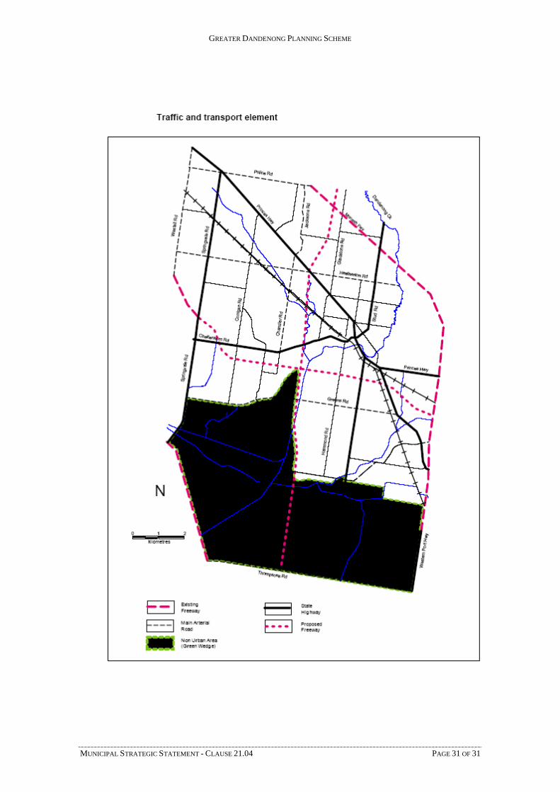
21.04-8 Traffic and transport
Overview
Extensive transport networks link Greater Dandenong with all sectors of the metropolitan area and the south-east region. These networks include public transport and major arterial roads providing access to the Melbourne CAD, ports and airports. The road network is vital to the movement of freight to local, interstate and international markets. The Dandenong Station/train/bus modal interchange is a major regional public transport hub.
The proposed Dingley Freeway and the Westall Road duplication represent significant expansion and enhancement to the municipality’s transport network. The future of the Scoresby Transport Corridor, linking Ringwood to Frankston via a series of new freeways and arterial road improvements, is currently under review by the Roads Corporation.
Objectives
What we want to achieve is:
To ensure the transport needs of the local community are addressed in a manner that minimises air pollution, reduces stress and provides for safe vehicle, pedestrian and bicycle movement.
To facilitate the development and management of effective transport networks which focus on measures to enhance economic development and local environmental amenity while improving safety, access and mobility for all users.
To encourage increased use of public transport.
Strategies
These objectives will be achieved by:
Facilitating the strategic development of major road infrastructure projects to improve the existing network for road users with emphasis on the movement of bicycles, people and pedestrians.
Promoting medium-density housing around scheduled public transport stops where there is access to commercial and community facilitates and open space links.
Facilitating the implementation of the recommendations of the Dandenong CAD and Environs Structure Plan and Transport Strategy (WSC Consultants 1997), including developing a new major bus station in the north-east sector of the CAD accessible to the Dandenong Market, Lonsdale Street and Dandenong Plaza.
Facilitating the construction of the Scoresby Transport Corridor, Dingley Freeway and Westall Road duplication.
Identifying land with drainage and flood constraints and ensuring development responds to these constraints.
Facilitating the closure and realignment of Cheltenham Road as part of the Dandenong Railway Precinct Redevelopment.
19/01/2006 VC37

GREATER DANDENONG PLANNING SCHEME
Implementation
These strategies will be implemented by:
Policy and exercise of discretion
Encouraging medium-density housing to locate near activity centres which have access to public transport.
Zones and overlays
Including public and private land required for the Dingley Freeway, Scoresby Transport Corridor, Cheltenham Road realignment and the Westall Road duplication in a Road Zone, Category 1, or a Public Acquisition Overlay for a Category 1 road.
Applying the Special Building Overlay to land affected by overland flows in storm events that exceed the capacity of underground drainage systems.
Further strategic work
Other actions
Reference documents
Dandenong CAD and Environs Structure Plan and Transport Strategy (WSC Consultants 1997).
Dandenong Railway Precinct Comprehensive Development Plan (Tract Consultants Pty Ltd August 2003).
MUNICIPAL STRATEGIC STATEMENT - CLAUSE 21.04 PAGE 30 OF 31
GREATER DANDENONG PLANNING SCHEME
MUNICIPAL STRATEGIC STATEMENT - CLAUSE 21.04 PAGE 31 OF 31