2.1 Review of previous studies and recent initiatives
16
15 2.1 - Review of Previous Studies and Recent Initiatives Streets For All – North West (English Heritage, 2005) The purpose of this publication is to provide a reference manual of good practice to help inform a range of professions working for local authorities. It is important to recognise that the economic success of cities is linked to the quality and distinctiveness of the public realm. Key Issues: • Accessibility – Emphasis on access for all. Holistic approach to the design of the public realm, including non-standardised approach to highways design. • Regional characteristics - Materials used in historic public realm is largely influenced by underlying geology and local sources of stone. Ideally, this approach should be replicated in the selection of new materials for the public realm, although this is reliant on close liaison between the local authority and local suppliers to ensure a suitable product and supply is available. Before producing any guidance, it is important to establish what is found in the existing public realm and what it is about the area that is locally distinctive • DDA legislation – Requirement for even surfaces along historic routes, for example, can present a challenge. DDA legislation does not override other legislation, such as conservation, health and safety and highways acts. Must ensure that a reasonable approach is taken. • Integrated townscape management – It is a concern that no single authority or agency has overall responsibility for the public realm. There is a need for coordinated working and it is recommended that this is achieved through the establishment of a Public Realm Management Team, which would carry out decision making on a consensual basis. Each subsequent section addresses each of the main components that affect the appearance of streets and offers guidance on the approach that should be taken. Ground Surfaces • Relate surfacing to its streetscape context. • Invest in quality (i.e. natural, local materials), considering sustainability in terms of life-cycle costings. Consider prioritising the application of more expensive naural materials through use of a street hierarchy. • Promote simplicity – avoid small paving units in arbitary colours and patterns (small modules are best confined to carriageways and crossing points). A seamless, simple and neutral floorscape should be chosen to complement the surrounding architecture. • Maintain the historic form of streets by maintaining kerb lines. Use kerbs to provide definition and reduce the need for bollards etc. Consider colour contrast for visually impaired people. • Where historic surfaces, kerbs and drainage features survive these should be maintained and restored (in some cases by stripping tarmac away). Specialist conservation advice should be sought before any work is carried out. • Respect the proportional relationship between footways, buildings and carriageways. Where footways are extended or carriageways raised the kerb line should still be demarcated (with 25mm upstand in the case of raised carriageways). • Respect local designs and details, but adapt designs to address new problems. For example, where setts and cobbles are used, smooth surfaces should be laid at junctions and crossings to assist crossing by pedestrians. At a naƟonal level English Heritage has prepared guidance on the design of streetscapes for 9 English regions through their ‘Streets For All’ publicaƟons. The following provides a summary of relevant informaƟon contained in ‘Streets For All – North West’. In addiƟon, Appendix C contains further details of relevant naƟonal guidance that may be of interest. Existing Public Realm Context 2.1 - Review of Previous Studies and Recent Initiatives
Transcript of 2.1 Review of previous studies and recent initiatives

15
2.1 - Review of Previous Studies and Recent Initiatives
Streets For All – North West (English Heritage, 2005)
The purpose of this publication is to provide a reference manual of good practice to help inform a range of professions working for local authorities. It is important to recognise that the economic success of cities is linked to the quality and distinctiveness of the public realm.
Key Issues:• Accessibility – Emphasis on access for all. Holistic
approach to the design of the public realm, including non-standardised approach to highways design.
• Regional characteristics - Materials used in historic public realm is largely influenced by underlying geology and local sources of stone. Ideally, this approach should be replicated in the selection of new materials for the public realm, although this is reliant on close liaison between the local authority and local suppliers to ensure a suitable product and supply is available. Before producing any guidance, it is important to establish what is found in the existing public realm and what it is about the area that is locally distinctive
• DDA legislation – Requirement for even surfaces along historic routes, for example, can present a
challenge. DDA legislation does not override other legislation, such as conservation, health and safety and highways acts. Must ensure that a reasonable approach is taken.
• Integrated townscape management – It is a concern that no single authority or agency has overall responsibility for the public realm. There is a need for coordinated working and it is recommended that this is achieved through the establishment of a Public Realm Management Team, which would carry out decision making on a consensual basis.
Each subsequent section addresses each of the main components that affect the appearance of streets and offers guidance on the approach that should be taken.
Ground Surfaces• Relate surfacing to its streetscape context.
• Invest in quality (i.e. natural, local materials), considering sustainability in terms of life-cycle costings. Consider prioritising the application of more expensive naural materials through use of a street hierarchy.
• Promote simplicity – avoid small paving units in arbitary colours and patterns (small modules are best confined to carriageways and crossing points). A seamless, simple and neutral floorscape should be chosen to complement the surrounding architecture.
• Maintain the historic form of streets by maintaining kerb lines. Use kerbs to provide definition and reduce the need for bollards etc. Consider colour contrast for visually impaired people.
• Where historic surfaces, kerbs and drainage features survive these should be maintained and restored (in some cases by stripping tarmac away). Specialist conservation advice should be sought before any work is carried out.
• Respect the proportional relationship between footways, buildings and carriageways. Where footways are extended or carriageways raised the kerb line should still be demarcated (with 25mm upstand in the case of raised carriageways).
• Respect local designs and details, but adapt designs to address new problems. For example, where setts and cobbles are used, smooth surfaces should be laid at junctions and crossings to assist crossing by pedestrians.
At a na onal level English Heritage has prepared guidance on the design of streetscapes for 9 English regions through their ‘Streets For All’ publica ons. The following provides a summary of relevant informa on contained in ‘Streets For All – North West’. In addi on, Appendix C contains further details of relevant na onal guidance that may be of interest.
Existing Public Realm Context2.1 - R
eview of Previou
s Stud
ies an
d R
ecen
t Initiatives

16
• Well laid paving is fundamental to the appearance of the street, complex detailing should be laid out prior to being constructed to make sure the correct approach is taken. Cut slabs at corners to local radius patterns and cut slabs to conceal inspection covers. Install tactile paving as an integral part of design and not an afterthought. Where vehicle overrun is likely, lay slabs on a concrete base and use robust materials.
• Use road markings sparingly in sensitive areas, consistent with safety standards. In historic areas avoid obtrusive colours and markings for cycle lanes.
• Promote access for all and consult with local access and cycle groups on detailed designs. Careful integration of ramps and detailing of steps to accommodate level changes. Design footpaths and cycle routes as an integral part of the public realm.
Street Furniture• Identify and remove superfluous or redundant
items (signs, railings, seats, bollards etc) and reduce the introduction of new furniture through good design.
• Avoid clutter by fixing signs, traffic signals and lighting onto existing buildings or other street furniture (preferably at the back of pavement) wherever possible.
• Coordinate the style, colour and siting of street furniture. New furniture should be simple, elegant, robust and appropriate to the context. Consider multi-functional design.
• Consult local access groups and disability organisations on their needs.
• Preserve historic street furniture and older signs, and unless beyond repair, make plans for their maintenance. Consider recasting local designs, ensuring details are accurate and authentic.
• Restrict the size and number of traffic signs to those that convey essential information only. Use dark/receding colours for posts and avoid large backing panels/backgrounds. Use internal illumination (in preference for externally illuminated).
• Locate control boxes for traffic signals unobtrusively.
• Only use pedestrian guardrails or bollards where other safety measures are inappropriate and use designs that relate to the townscape.
• Consider raising kerb heights/definition to avoid the need for physical barriers, such as railings and bollards.
• Crossings should be free of clutter, and where possible, single stage.
• Select lighting that is appropriate to the function of place and is considered in relation to other light sources and respects local designs. Avoid light pollution and consider the daytime appearance of light fittings.
• Design seating as an integral part of the street and locate in places of interest/activity.
New Equipment• Site equipment at the back of footway.
• Take into account the character of the townscape before introducing new items.
• Retain all post boxes and new boxes should complement existing stock.
• Retain traditional telephone kiosks. New telephone kiosks should be located appropriately and different styles should not be located together.
• Incorporate parking information, warning signs and pay and display machines together and minimise the need for new posts.
• Street cabinets should be located at the back of footway, painted in an appropriate colour and robust panel surfaces used to discourage flyposting.
2.1 - Review
of Previous Stu
dies a
nd
Re
cent In
itiatives

17
• Appropriate, accessible and low profile locations should be chosen for street recycling facilities.
• CCTV cameras should be located discreetly on buildings or on existing posts.
• Cycle stands should be simple, robust units that are positioned in convenient locations for cyclists, without obstructing others.
• New design elements in the public realm should be fit for purpose, durable, vandal resistant, of architectural quality and appropriate to context.
• A strategy for advertising should be prepared that takes into account the special character and distinctiveness of the area.
Traffic Management• Traffic calming measures should involve features
or devices that use traditional materials and relate to the design of the overall townscape.
• Traffic signs should be kept to an absolute minimum.
• Schemes should not be designed solely by highway engineers without obtaining specialist design advice, as standard solutions will rarely be appropriate.
• Major schemes in conservation areas should always be referred to English Heritage for advice and guidance.
• Well designed gateways and use of traditional granite setts may be more costly initially, but are considered a sound investment. Where budgets are limited, doing less but of a high quality is better than compromising on quality.
• Provision for pedestrians and cyclists should be integrated into designs.
Environmental Improvements• Pedestrianisation schemes require sensitivity.
Kerb lines should always be retained and a clear definition created between ‘footway’ and ‘carriageway’ through the materials used.
• Kiosks selling newspapers, fruit and vegetables etc. should be encouraged as they enliven streets. Good quality design of kiosks/stands must be encouraged.
• Temporary public art should be promoted.
• When commissioning public art consideration must be given to setting a clear brief, the appropriate scale, durability, lighting, visibility and landscape context.
• Select and locate trees in the public realm using specialist advice and only use planting where it would make a positive contribution to the townscape.
• Appropriate design of tree pits should avoid maintenance liabilities, and the creation of litter traps and hazards for visually impaired people/wheelchair users.
• The lighting of buildings should select target buildings in relation to the townscape. Daytime aesthetics should be considered and designs should be considered in relation to street lighting schemes.
A number of studies and masterplans have been completed or are currently being prepared for areas within Chester city centre. It is important that the design guide builds on the findings and plans contained within these reports. The following provides a summary of those studies and current initiatives/developments that are of particular relevance to the PRDG. Appendix C contains details of other reports that may be of interest.
Chester’s Historic Public Realm - The Walls and Roman Gardens (Alan Novelli Fee)
2.1 - Review
of Previous Stu
dies a
nd
Re
cent In
itiatives
18
Chester – A Study in Conservation (Donald W Insall and Associates, 1968)
Commissioned jointly by the Minister of Housing and Local Government and the City and County Councils concerned, the conservation study provides an excellent urban analysis of Chester which is still very relevant to the PRDG although some of its recommendations and conclusions are understandably not inline with current best practice.
Chester’s Local Distinctiveness Strategy (Chester City Council, September 2002)
In response to the threat posed to Chester’s local distinctiveness the LODIS (Local Distinctiveness) Partnership was established in order to recognise what makes Chester distinctive, with the aim of protecting and enhancing key assets. The strategy begins by confirming that Chester’s local distinctiveness is key to attracting people to the city and that investment in local distinctiveness will increase economic growth. The strategy goes on to identify key aspects of Chester’s local distinctiveness relevant to the PRDG and areas for improvement as follows:
Events and Attractions• Buskers: Ensure always high quality, increase
locations and ensure pedestrian flows not impeded.
• Town Crier: Need funding to continue with regular proclamations.
• Chester Races: Need to enhance route from Watergate Street, also key venue for other festivals.
• Cultural Venues: Lack of cultural venues – gallery/performing arts space.
• Watch Parades: Improve interpretation, publicity and support.
• Mystery Plays: Improve interpretation, publicity and support.
• Chester Zoo: Improve connections to the city – physical links, linked visits etc.
Tourism • Grosvenor Hotel: Need city centre access to be
maintained.
• International visitors: Create cosmopolitan feel. Issue of space along narrow streets around The Cross.
Shopping • Diversity of traders: Support specialist shops.
• The Rows: Improve access and signage.
• Markets: New covered market to Northgate development and outdoor market in Town Hall Square.
Location• Access by car: Access is good, but car parking is
limited
• Rail: Rail service poor
Townscape• Public realm: Street furniture not unique (should
be locally distinctive), car parks visually poor, poor surfacing, architectural lighting not fully implemented.
• Defined edges: Reinforce edges/gateways between city centre and suburbs.
• Density of built form: Retain compact built form to city centre.
• Green spaces: Green fingers create extension from countryside into city centre. – improve links further using river and canal.
• Outward views: Views to countryside should be protected.
• Pedestrianisation: Extend pedestrian friendly streets – improve links between core and watersides.
• The River Dee: Lack of crossings on the west side of the city centre, potential for continuous walk linking green spaces.
• The Canal: underutilised – Lack of interpretation and distinct furniture and public art.
2.1 - Review
of Previous Stu
dies a
nd
Re
cent In
itiatives

19
2000 Years of Built Heritage• City Walls: Green Moat concept – improving green
setting to walls (including unsightly car parks and building rears) and improve recent gateways. Highlight old route of Roman walls.
• Gateway Thresholds: New spaces at Watergate and Newgate, branding of gates, lighting and artworks.
• The Castle: Forecourt should be used as open
space for events, enhance entrance from Walls and Little Roodee.
• The Cathedral: A central part of Chester’s built heritage.
• Amphitheatre: Events venue, new Roman Interpretation/Visitors Centre – create vertical presence.
• Roman Chester: Roman trail around exposed remains with interpretation.
• Chester’s Rows: Encourage more activity on Rows – dining/trading.
• Black and White Architecture: Distinctive to Chester.
Chester Riverside Development Brief (Chester City Council, September 2002)
This Development Brief covers Chester’s historic riverside to the south of the city centre. The brief identifies that the area has unique qualities and that its history should be used to develop a colourful, vibrant and distinctive mixed use area.
The general aims set out in the Development Brief, which are of particular relevance to the PRDG are:
• To provide strong pedestrian linkages between Eastgate Street/Foregate Street and the riverfront. This would be partly achieved through the creation of improved crossing points, as well as public realm improvements to Lower Bridge Street, consisting of extension of footways, footway resurfacing, architectural lighting and pedestrian orientation signage.
• To reinforce Grosvenor Bridge as a key gateway into the city, through the use of architectural lighting to the bridge and vertical public art features at the break in the city wall.
• To transform the Chester Castle area into an active and colourful visitor destination.
• To fully expose and interpret the Roman Amphitheatre to make more of this key asset.
• To overcome the barrier and severance created by the ring road, with proposals for major improvements to the public realm at the Bars Roundabout including the reinstatement of historic gates as an art feature.
• To rediscover important city spaces and squares.
• To reinforce the Groves as Chester’s seaside resort.
• To provide a series of major outdoor festival/entertainments venues at Grosvenor Park, the Roman Amphitheatre, the Groves, Castle, Little Roodee and Roodee.
Suspension Bridge at the Groves
2.1 - Review
of Previous Stu
dies a
nd
Re
cent In
itiatives

20
Gorsestacks Development Brief (Chester City Council, December 2002)
This Development Brief covers the Gorsestacks area of the City Centre which wraps around the north-eastern edge of the city, close to the canal and Chester Cathedral and adjacent to the ring road. The brief sets out a vision for mixed use development across a series of development parcels, with landmark buildings proposed to front the ring-road roundabouts. The Victoria Road/George Street/Delamere Street area includes proposals for linked courtyards and an open space framework linking the development and streets to the canal, via a canal side park and two new canal crossings.
The aims for the redevelopment of the Gorsestacks area of particular relevance to the PRDG include:
• Use of the area’s rich history to create a colourful, vibrant and distinctive new quarter to the city.
• The protection and exploitation of key views of the Cathedral and City Walls.
• The creation of better links to the station via Brook Street and Frodsham Street.
• The transformation of George Street and Gorsestacks into an attractive city street and link between Northgate and Frodsham Streets.
• The reinforcement of the Cow Lane Bridge canal basin as an attractive canalside visitor hub.
Public realm proposals have since been developed for this area. Other key proposals contained in this Development Brief and relevant to the public realm include:
• The narrowing of the highway at the eastern end of Gorsestacks.
• A tree lined frontage to the ring road between Hoole Way and Victoria Road.
• A new coach pick-up and drop-off.
• Closure of the subways to the ring road roundabouts.
• Public art to the ring road roundabouts and within new courtyards/squares.
• Creation of a pedestrian-friendly canalside walk along George Street.
• A home-zone approach to streets within the new development that provide suitable opportunities for informal play.
• Replacement of the surface car parks with multi-storey and undercroft parking.
Chester Culture Park (Chester City Council)
The aim of the Chester Culture Park is to ‘make Chester a must see European City by 2015’. The Chester Culture Park report aims to provide an integrated programme of culture and visitor development and management in Chester. The Visitor Management Framework opposite (Figure 2.1) forms the basis of the culture park strategy and its aim is to enable residents and visitors to encounter everything Chester has to offer in a coherent way.
2.1 - Review
of Previous Stu
dies a
nd
Re
cent In
itiatives

21
Figure 2.1 Chester Culture Park Visitor Management Framework 2.1 - Review
of Previous Stu
dies a
nd
Re
cent In
itiatives

22
The key elements of the Culture Park Visitor Management Framework are listed and explained below.
• The Heart: Eastgate Street between The Cross and Eastgate Clock represents Chester’s distinctive centre.
• Culture Park Gateways: Main arrival nodes into the city centre comprising the railway station, bus station, Little Roodee coach park, Little St John Street coach drop-off, car parks, park and ride sites and canal.
• Gateway Routes: Main routes linking the gateways to the Eastgate Heart.
• Chester’s Row Streets: The Rows core is the main retail/food/drink area.
• Culture Park Zones: These are the key distinctive places in Chester and are identified as Amphitheatre Park, The Groves and Riverfront, Castle Gateway, Chester Ports and Wharfs, Gorsestacks Canal Front and Cathedral Precincts. The report considers how each of these zones should be developed to be well connected and with a clear focus (zone hub). They should also provide signed and interpreted routes. Each zone should tell a series of stories and new attractions should be created, which could be facilitated by the creation of new events spaces.
• Zone Hubs: The Zone Hubs represent the focus of activity in the zones. These are considered to be orientation and refreshment points, as well as having the potential to host events. The key proposals for each of the zone hubs are summarised below.
- Amphitheatre/Little St John Street – New Roman Centre and Visitor Information in an iconic building (replacing existing), shops/cafes/restaurants and outdoor theatre and events space.
- The Groves – Refurbish the public realm and provide signage, waymarking and interpretation.
- Castle Square and Inner Bailey – New piazza, events area on car park forecourt, visitor information and interpretation, architectural lighting scheme, community artist studios in gun sheds and creation of a smaller events and alfresco dining area in the Inner Bailey.
- Crane Wharf – Improvements to the waterfront space to create vibrant riverfront square with alfresco dining, events and public art (as part of riverside walk). Hub should include visitor and community information and interpretation.
- Tower Wharf Basin – Moorings around basin and development of shops, bars, cafes and restaurants.
- Town Hall Square and Northgate Street – Civic space as venue for outdoor market and events, alfresco dining, interpretation and visitor/community information and public art.
- Cow Lane Bridge Basin – Moorings, canalside promenades with alfresco dining, festival shopping, civic offices and forecourt.
• Zone Routes: These are the main walking routes between the Eastgate Heart and each of the Zone Hubs.
• Pedestrian Link Route: This comprises the City Walls and green moat concept, providing a link and views to all zones.
• Water Scenic Routes: A ‘longer’ walking circuit, based on the riverside and the canalside walkways and routes, linking all of the zones together.
• Main Events Area – The Roodee: Recognised as an opportunity for regular and major events/festivals.
• Chester’s Green Network: Green network to link Culture Park with wider open space framework via pedestrian/cycle routes.
The City Walls - a key pedestrian link route
2.1 - Review
of Previous Stu
dies a
nd
Re
cent In
itiatives
23
Chester City Walls Conservation Management Plan (Donald Insall Associates Ltd)
Chester has the most complete and intact city walls in Britain and they are recognised as being of international importance. The Conservation Management Plan (CMP) was commissioned in response to concerns about the condition and management of the walls. The CMP sets out a series of policies and actions for the management and improvement of the walls in response to the survey findings. The following policies are relevant to the PRDG:
Maintenance• Maintain the walls to the highest standard,
befitting a Scheduled Ancient Monument.
• Undertake regular inspection of lighting and drainage, as well as cleaning of surfaces and signage and a cyclical programme of repainting.
Accessibility• The walls should be physically accessible to as
many as possible.
• Where access is not possible alternative means of appreciating and understanding the walls should be provided.
• Physical links with Chester Castle need to be exploited.
• Some parts of the walls are locked-up and inaccessible to all. This needs to be addressed.
Environment and Setting• The CMP identifies a need to mark the transition
from the suburbs to the ancient city through a change in the paving surface at gateways and breaks in the walls.
• There is concern about the proliferation of signs, wires and pipes at gateways to the Walls which undermines the quality of place.
• Façade improvements and backland improvements are needed to some built form viewed from the walls, particularly to the rear of properties along the western half of the walls (Frodsham St, St Werburgh St, St John St, Newgate St and Souter’s Lane).
• Car park improvements are proposed, which would include more subtle bay markings and use tree and other planting to soften appearances.
• Soft landscape improvements are identified, mainly to the north along the canal.
• General backland improvements are identified for a belt of built form all the way round the walls and should include better containment/screening of services, more thorough inspections and cleaning and better overlooking (opening up of windows).
• There is a need to formally identify views that
need protection (through development control and land management).
• Feature lighting on the walls is patchy.
City Walls-Thimbleby’s Tower
2.1 - Review
of Previous Stu
dies a
nd
Re
cent In
itiatives
24
Interpretation and Signage• Strong and consistent branding is needed which
clearly identifies the walls amongst other visitor attractions.
• Existing wayfinding is too subtle and not adequate enough to help visitors locate access points to the walls. The CMP recommends that the location and function of waymarking signs is reconsidered.
• Existing interpretive information is not easy to read and there is no interpretation of views from the walls. An interpretation plan is recommended for the walls.
Chester Cycle Demonstration Town (2008)
In 2008, Chester was identified as one of seventeen official Cycling Demonstration Towns and will benefit from over £7 million of funding in the next three years. The initiative aims to improve Chester’s cycling infrastructure and cycling opportunities, with the aim of making cycling the most obvious transport choice for journeys around Chester.
The council are currently consulting with the public to decide on priorities (capital projects) for the transport capital programme (LTP3), which will run from 2011. Examples given relevant to the PRDG are:
• Hoole Road Bridge improvements;
• Complete, safer cycle routes (such as from the zoo to city centre);
• Tackling dangerous roundabouts on the Chester ring roads; and
• Improved bridges or new bridges.
Chester Rail Gateway Strategic Sites Study (GVA Grimley Ltd, November 2008)
GVA Grimley was commissioned by Cheshire West and Chester, Cheshire and Warrington Economic Alliance and the NWDA to assess the employment potential of the Chester Rail Gateway opportunity sites and to provide overall information and recommendations, as well as specific consideration of the suitability of sites to be put forward in an ERDF bid.
Property market analysis revealed that there is potential to deliver a significant city centre office development, including a major office led business district in the city centre (HBOS/canal area, east of the city or Gorsestacks area) and new business hub facility closer to the station (Hoole Bridge/Station gateway area). The report concluded that external funding may be available through ERDF, single programme and possibly JESSICA.
GVA Grimley are now looking at this area in greater detail as part of a related study considering the regeneration and development potential for major commercial and business investment.
Ideas for Developing Chester’s Northgate Street into a Destination – (November 2008)
This report was commissioned by the NWDA, Cheshire and Warrington Tourist Board and other
stakeholders and focuses on ideas for developing Chester’s Cathedral quarter and specifically within this, Northgate Street. It was undertaken by Locum Consulting as a Northwest Economy Pilot Project.
Three concepts are identified in the study for sub-areas in the quarter that could be developed as follows:
1) St Werburgh Street – potential to create a plaza containing a water feature and overlooked by shops and bars.
2) Abbey Square – this could be a focal public space of high quality containing a classic and discrete hotel.
3) Northgate Street – at its northern end this has an independent character. Although low profile at the moment, this has the potential to be promoted as a village.
The report goes on to suggest ideas for the development of the ‘Northgate Street Village’. The following ideas are of particular relevance to the PRDG.
• Develop a physical presence for the village’s brand/logo through artworks, signage, banners and shop front designs.
• Introduce animation to the street with outdoor cafes and market stalls.
• Reduce the impact of traffic. Ideally the street would be pedestrianised, but otherwise widening of pavements and a reduction in the amount of traffic would be beneficial.
2.1 - Review
of Previous Stu
dies a
nd
Re
cent In
itiatives

25
Chester Interpretation Masterplan(Imagemakers, March 2009)
The Chester Heritage Interpretation Masterplan (IMP) is a strategy ‘for telling Chester’s stories in the public realm’ and focuses on the interpretation required to support Chester’s Culture Park.
The IMP report recognises that the framework proposed as part of the Culture Park (reviewed earlier in this section) is not definitive and will require further refinement as subsequent related studies and projects develop. The IMP proposes some adjustment to the zones based on their heritage interest. The IMP also recommends that the zone boundaries, position of zone hubs and gateways etc. are defined through a branding and signage strategy.
The IMP sets out a series of ideas for interpretation under the two main overarching themes which are captured in the following statements:
- ‘Chester began, grew and flourished because of its position on the River Dee’
- ‘Same Space, Different Place: 2,000 years of colourful history and heritage can be seen, felt and heard in Chester’
The report presents a series of design concepts for generic signage elements, further detail on the design concepts and materials is presented in the Wayfinding Strategy in Part 6 of the PRDG. The IMP identifies and prioritises a wide range of interpretive projects of relevance to Part 6 - Wayfinding and Signage Strategy and Part 4 – Public Art Strategy of this PRDG (see further detail in these parts).
The projects identified include proposals for the production of further detailed interpretation plans, installation of signage, public art and the production of leaflets and web-based media.
Chester Renaissance Project - Castle Quarter Vision (BDP, 2009)
This report by BDP for Chester Renaissance provides a vision and set of recommendations for the Castle Quarter, which are relevant to the PRDG.
The report recognises that at present there is little reason or opportunity for visiting the castle and considers the future of the castle in the context of the wider quarter and city. The culmination of this study is a visionary masterplan which aims to create a fitting gateway to the city, appropriate setting to the castle and significant tourist destination. The masterplan consists of the following elements:
1) Restoration and improvements to the castle buildings (detailed requirements are set out in the Castle’s Conservation Management Plan).
2) A new performing arts centre is proposed on the site of the existing Little Roodee coach and car park. Parking would be partly reprovided through undercroft parking as part of the new building. The flowing form of the green roof would form a ‘castle park’ above. The new building would also accommodate a series of commercial leisure/retail units fronting a new public space on the riverside.
3) A new gateway building is located at the point of the city wall crossing Grosvenor Road. This is described as a simple visitor leisure/commercial opportunity and could also improve access to the Roodee.
4) A series of pavilion buildings are dotted around the existing castle offering space for a restaurant/bar, other commercial uses and a galleried access to the castle from Castle Drive and the river.
5) Castle Square would become a new public square and events space.
The masterplan for the castle is ambitious, but deliverable and a central recommendation is that the plan is integrated into Cheshire West and Chester’s future planning policy framework for the Castle Quarter.
Chester’s Castle Quarter
2.1 - Review
of Previous Stu
dies a
nd
Re
cent In
itiatives

26
The Rows Draft Conservation Management Plan(BDP, 2009)
The Rows Conservation Management Plan (RCMP) has been prepared to secure effective conservation and management of this key townscape and heritage asset. The Rows are important because they are key to Chester’s character and encompass the largest surviving group of medieval town houses in the country with the unique elevated walkways and first floor shop fronts. The condition, appearance, use, management and interpretation of The Rows is considered to be seriously deficient due to problems caused by the complexity of ownership and responsibility, which has led to poor management.
The vision for the Rows is to be a ‘must-see’ part of Chester that combines a unique historic setting with a high quality mix of shops, bars and restaurants, with the management and interpretation worthy of a site of international heritage importance. It is anticipated that the RCMP will inform strategic Council planning documents.
The opportunities identified, amongst others, are to improve the public realm and environment (especially at Rows level), to create an overall identity for the Rows and to create a coordinated signage policy. Key proposals in the RCMP framework strategy are to establish a Rows information/visitor centre, to identify a series of management principles provided in an occupier’s handbook and to create destinations beyond The Rows at the extremities of Northgate, Watergate and Bridge Streets and also on ‘backland streets’ such as Commonhall Street. These destinations will help to re-establish pedestrian circuits and routes of discovery.
The document also sets out parameters for the appropriate design of:
• Shop fronts (recognising the range of existing types of units)
• Signage
• Al fresco arrangements
• New access points
• Design of entrance thresholds (including the accommodation of level changes)
• Lighting
• Security
This guidance is referred to within the PRDG. The report follows with three site studies:
A – Corner of Bridge Street and Watergate Street: identifying areas for improvement
B – Bridge Street and Fletcher Buildings: exploring potential development of backland area
C – St Werburgh Street and Godstall Lane: example of good practice
The Cathedral Quarter Vision (BDP, 2009)
BDP was commissioned to produce a vision and masterplan for the Cathedral Quarter. A copy of this report has not been available for review, however one of the outcomes of the Cathedral Quarter Vision is the subsequent detailed design commission for St Werburgh Street (see below).
St Werburgh Street Detailed Design and the public realm (BDP, 2010 – current)
Following the initial piece of work on The Cathedral Quarter Vision, a further more detailed commission is being undertaken by BDP to prepare designs for St Werburgh Street and the public realm surrounding the southern side of the cathedral. This design work has been ongoing as the PRDG has been prepared and consultation has been undertaken to ensure coordination between the PRDG and this more detailed piece of work.
Chester’s City Walls and Towers –Competitiveness Study (Donald InsallAssociates, 2010 - current)
This study looks at the current economic contribution of the City Walls to Chester’s visitor economy. The report considers the best way of improving the walls to boost their contribution to the economy.
The study was financed by the ERDF funded PORTICO project, which will provide investment for repairs, enhanced interpretation, access improvements and research into how the walls can contribute to the economy. The project places particular emphasis on new uses for the towers (which could include
2.1 - Review
of Previous Stu
dies a
nd
Re
cent In
itiatives

27
suitable commercial activities). One of the key aims of the project, of relevance to the PRDG, is that of enhancing the walls as a thoroughfare and key piece of visitor infrastructure, providing a link to other attractions. Other proposed enhancements of particular relevance include the following:
• Improve both architectural and amenity lighting, with amenity lighting encouraging use of the walls by pedestrians a night.
• Develop a brand for the walls within the wider Chester brand that is used in new interpretation and signage.
• Carry out the redesign and replacement of the interpretation plaques located on the walls and develop a mobile audio tour (in line with the proposals contained in the IMP).
• Improve access arrangements for those with lesser mobility or sight impairments (major improvements for wheelchair access are considered unfeasible at present). 34 locations have been identified as requiring improvement and 5 pilot sites have been identified for improvements in the short term.
• Improve signage to access points on the walls and waymarking of the route itself. These should match the brand developed for interpretation signage and be integrated into improvements for city-wide signage (as proposed in the IMP).
• Enhance the greenspaces connected to the walls as part of the ‘Green Moat’ concept. This will improve the visibility of the walls and encourage movement on and off the walls route.
The report goes on to prioritise these interventions, based on the actions required, with the aim of maintaining the existing economic contribution of the walls. The report recognises the importance of good management/maintenance of the walls, which should be achieved through a coordinated/unified approach, ideally led by a ‘Walls Manager’.
Portico: City Walls – Consultation Brochure(Donald Insall Associates, April 2010 – ongoing)
Following on from Donald Insall Associates’ preparation of a Conservation Management Plan for the City Walls and initial commission to carry out a ‘Competitiveness Study’ as part of the Portico Project (see previous reviews); the same consultant was appointed in January 2010 to prepare a masterplan for the city walls and develop designs in order to implement selected projects using Portico funding.
Portico is an ERDF funded cooperative project, involving collaboration between Utrecht in Netherlands (lead partner), Initiatief Domplein in Utrecht, Koln in Germany, Ghent in Belgium and Chester. The project’s aim is to make the city’s archeological heritage visible through above and below ground techniques and developments. In Chester, the objective is to make the city walls the best urban heritage trail in Europe, through lightweight interventions that enhance how the users experience, understand and enjoy Chester’s built heritage.
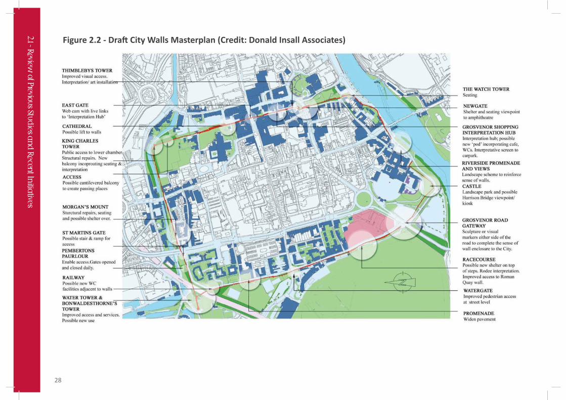
The draft masterplan presented in the consultation brochure is shown overleaf. (Figure 2.2)
City Walls-King Charles Tower
2.1 - Review
of Previous Stu
dies a
nd
Re
cent In
itiatives
28
Figure 2.2 - Dra City Walls Masterplan (Credit: Donald Insall Associates)
2.1 - Review
of Previous Stu
dies a
nd
Re
cent In
itiatives

29
The masterplan contains the following elements which are proposed to be delivered through Portico funding (subject to detailed costings):
• Newgate: Amphitheatre viewing platform with canopy and seating. New openings in north and south towers to offer sheltered seating and audio interpretation. Existing parapets modified to facilitate views.
• King Charles Tower: Structural intervention and opening up of windows, incorporation of audio interpretation, lighting and signage. Unmanned public access to room at walls level. Upper level would be available for guided public access. Cantilevered balcony proposed as additional gathering space on walls route.
• Water Tower Complex: Improved public access and repairs. Depending on cost - possible inclusion of Water Tower Bridge, off Tower Road (with pod containing WC/services).
• Morgan’s Mount: New weatherproofed deck with canopy, offering sheltered viewing point.
• Thimbleby’s Tower: Improvements, possible internal access and interpretation.
• Racecourse/Roodee Interpretation Hub: Cantilevered deck with canopy and seating.
• Grosvenor Interpretation Hub: Dependent on funding. New build interpretation hub to be located in the gap between Grosvenor Shopping Centre car park and the walls. Could include café, WC and interactive interpretation at walls level.
Other interventions, dependent on securing future funding, include:
• Eastgate: live webcam to provide virtual access for all (viewed from Grosvenor Interpretation Hub).
• Cathedral: lift to provide access from car parks to Cathedral Quarter.
• Ramped access at Rufus Court: lightweight ramp to allow level access to walls.
• Ramped access at St Martin’s Gate: new ramped and stair access.
• Bonaldesthorne’s Tower: Enable and improve access.
• Castle/University Gardens: Landscape scheme, including removal of timber fencing, provision of seating/kiosks.
• Handrail Replacement: replacement of existing handrails with lightweight type.
• Lighting: illumination of the city walls (as a monument, rather than the lighting of a route).
The consultation brochure concludes the feasibility stage of the project. The consultants will now start to prepare detailed designs for the elements that will be implemented using Portico funding.
Portico: Chester City Walls and TowersInterpretation Plan (Imagemakers, Draft ReportApril 2010 – current)
As part of the same project and working with Donald Insall Associates, Imagemakers has been appointed to develop an interpretation plan for the City Walls. The report divides interpretation projects into two categories:
1) Priority projects to implement through the Portico programme.
2) Aspirational proposals to be implemented as resources allow in the future.
Imagemakers emphasise the importance of the City Walls in offering the single best way to appreciate Chester on foot, providing views and connection to all of the key heritage sites.
The report sets out the overarching theme for the interpretation of the walls as ‘a regional stronghold’ and within this identifies primary themes and subthemes for interpretation, some of which are generic and some site specific.
2.1 - Review
of Previous Stu
dies a
nd
Re
cent In
itiatives

30
The proposals for Portico funded projects are:
1) A dedicated website
2) Orientation panels – Signs providing map based information at the main access/egress points along the walls.
3) City centre disabled access leaflet – Currently being produced by Cheshire West and Chester Council. This will include updated information on the City Walls (due to be printed April 2011).
4) Waymarkers – fingerposts or plaques may be needed to mark ‘all access detours’ proposed at St Martin’s Gate and Castle Drive.
5) Interpretation Panels – To replace existing.
6) Smart phone multi-media ‘app’ tour – For use on compatible mobile phones. Include maps and audio clips.
7) Other individual interpretation installations – majority are linked to intervention locations included in Donald Insall Associate’s masterplan.
8) City walls guide booklet – Update to match new interpretation.
9) Events and live interpretation – programme of events linked to school holidays.
The report goes on to list additional masterplan projects. These include a threshold design for Grosvenor Road gateway and lighting of walls and towers.
Further reference to this report is made in Part 6 – Wayfinding Strategy.
Chester Station and Approaches – Townscape Heritage Initiative (ongoing)
Chester Renaissance are responsible for overseeing a five year programme of investment in building conservation projects and public realm works along City Road, Brook Street and the Station itself. This project is now well advanced with significant improvements made on the ground to the station gateway and public realm. After two years of intensive work, achievements to date include:
• The redesign of the station square.
• Conservation and enhancement of the Grade II* listed station building.
• Improvements to station platforms and passenger facilities.
• Restoration of the east wing offices at the railway station.
• Restoration of important shop frontages on Brook Street.
New public realm scheme outside the railway sta on
2.1 - Review
of Previous Stu
dies a
nd
Re
cent In
itiatives