Cells divide, elongate & differentiate Lec. 3. Plant cells ...
Upload
ferdinand-yesaya-napitupuluCategory
view
213download
0description

GeoConvention 2013: Integration 1
Elongate tidal bar, amalgamated sub-tidal channel and estuarine point-bar successions of a sand-dominated open estuarine system; integration of outcrop and subsurface data, McMurray Formation, Ft. McKay, Alberta
Rudy Strobl*, Statoil Canada Ltd, Calgary, Alberta
Milovan Fustic, Statoil Canada Ltd., Calgary, Alberta
Bryce Jablonski, Statoil Canada Ltd., Calgary, Alberta
Summary
The Viewpoint and Amphitheatre outcrops near Ft. McKay, Alberta are visited frequently by geoscience and engineering staff on oil-sands field seminars, but interpretation is usually restricted to the lateral extent of the outcrops themselves. This paper integrates outcrop with subsurface borehole data to (i) map and interpret the reservoir quality on a well-pad scale, which can be used to further refine SAGD geomodels to help with mapping the 3-D geometries and (ii) demonstrate utility of outcrops for interpreting geology from core data. Comprehensive descriptions of these two outcrops are provided by Wightman et al., (1992), Wightman and Pemberton (1997) and Hein et al., (2001). Flach (1984). Wightman and Pemberton (1997) and Strobl et al., (1997) introduce the concept of paleo-topography, highlands on the Devonian surface and associated salt-dissolution as possible controls on depositional systems in the Ft. McKay area.
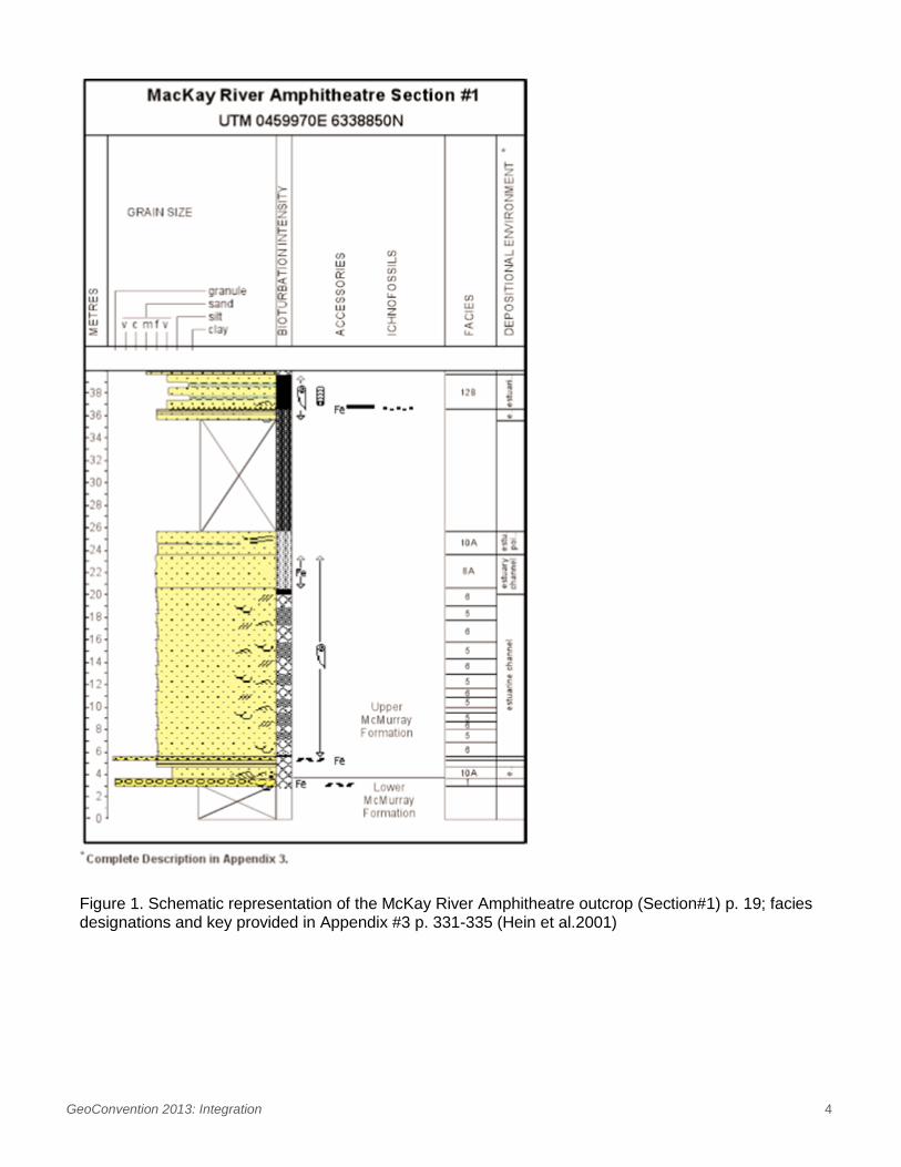
Wightman et al., (1992) and Wightman and Pemberton (1997) interpret the Middle McMurray succession exposed at the Viewpoint and Amphitheatre outcrops, as open estuarine. These outcrops are described as consisting predominantly of cross-bedded and bioturbated cross-stratified sand deposits. Double mud drapes associated with cross stratified sands offer evidence for tidal influence. Climbing ripple laminae that climb up the slip face of avalanche cross-stratification indicate potential subordinate flow in a tidal setting. Complementary interpretations to those of Wightman and Pemberton (1997) are provided by Hein et al, (2001) which include the potential to preserve tidal bar/inlet deposits (Figs. 1 and 2). Both papers reference tidal-fluvial point bar deposits along the upper portions of the Viewpoint and Amphitheatre outcrops.
The Amphitheatre and Viewpoint outcrops consist of a 15+ m thick successions of cross-stratified sand with trough cross beds generally less than 1 m thick, and units of ripple cross strata up to 2 m thick. Over steepened cross bedding may be associated with soft sediment deformation and continued subsidence caused by localized salt dissolution in the McKay area. Thin mudstone beds (less than 10cm thick) with limited lateral extent (less than 10m) are scattered throughout these sands; the mudstones tend to occur in the troughs of the cross beds. The upper part of the outcrop is comprised of interbedded sand/mudstone facies, each about 2 m thick, representing inclined heterolithic stratification (IHS; Thomas et al., 1987) interpreted as younger, smaller scale tidal channel deposits by Wightman and Pemberton (1997).

GeoConvention 2013: Integration 2
Trace fossils described by Wightman and Pemberton (1997) and Hein et al. (2001) in this sand-dominated succession include Cylindrichnus, Skolithos, and Bergaueria. Clasts consisting of mm to cm size ripped up trace fossils and coalified wood fragments are common throughout the section. Bioturbation is not as easily recognized in mudstones, but examples of Planolites and Skolithos are documented.
A cored well 1AA/09-27-094-11W4M is located approximately 800 m southwest of the Viewpoint and Amphitheatre outcrops (Fig. 3). At a depth of 10 m to 40 m below ground level, current ripple cross-laminated and bioturbated, cross-stratified sand deposits (Fig. 4) are observed in an interval equivalent to those observed and described by Wightman et al., (1997) and Hein et al., (2001) at the adjacent outcrops. Sands are bioturbated (commonly with Cylindrichnus burrows) with thin mudstone drapes and mudstone clast-breccias. Random, high angle dip and dip direction of tadpoles on a dip-meter are consistent with successions observed in the core that include cross-bedded, ripple cross-laminated and structureless sands, interbedded clast-breccia and mudstone drapes (Figs. 4 and 5).
At the top of the cored interval in the 1AA/09-27 well, a succession of sand-dominated and mudstone-dominated IHS is observed, similar to IHS described by Wightman and Pemberton (1997) and Hein et al., (2001) at the top of the Amphitheatre outcrop (Fig. 6). Similar lithofacies at similar elevations between the outcrop and the nearby cored well, provides strong evidence for correlation of high quality reservoir sands over a distance of over 800 m, equivalent to a SAGD pad. Interpretations and measurements obtained from continuous exposures of the associated outcrop can be used to characterize reservoir heterogeneity and assist with predicting reservoir performance. This data validates that the outcrop is representative of an open estuarine system preserved in the McKay area and can be used with a relatively high degree of confidence for modeling purposes.
Discussion
Combined study of McMurray Formation outcrops with nearby subsurface corehole data can be effective for characterizing oil-sands reservoirs in 3-D on several scales of investigation. Outcrops provide detailed data for assessing reservoir quality on cm to m scales and direct measurements of the spatial distribution of heterogeneities such as mud drapes or IHS beds. Measurements can include bed lengths, variation in bed thickness, grain size, paleo-currents and dips, all of which are beneficial for modeling purposes. Complementing outcrop studies with adjacent corehole data, commonly with 400+ m spacing between wells, provides the capability for 2-D mapping and 3-D reservoir characterization on a well pair or SAGD well-pad scale (on the order of 800m x 800m).
Although borehole data provides spatial distribution estimates for larger-scale architectural elements, interpretation and measurements of lateral variation of lithofacies are limited by the width of the core. Outcrop observations and measurements of lithofacies common to both core and outcrop, can be used for detailed scale characterization on the bed and lamina scales of investigation.
Contrasting open estuarine with younger fluvial-tidal channel deposits is essential to refine our understanding of the lateral continuity of oil-sands deposits, each with unique reservoir facies and architecture. Reservoirs consisting of tidal bar and amalgamated sub-tidal channel deposits are significantly different from reservoirs consisting of IHS-dominated fluvial-tidal channel deposits.
Wightman and Pemberton (1997) interpret late stage channel deposits, including outcrop 7 along the Steepbank River, as an upper estuary/fluvial part of the system, eroding most of the previous deposits. Younger fluvial-tidal channels on a smaller scale, such as those observed in the Amphitheatre outcrop, can result in partial preservation of open estuarine sands overlain by fluvial-tidal sediments. Large-

GeoConvention 2013: Integration 3
scale fluvial-tidal channels, such as outcrop 7 along the Steepbank River, can erode the entire succession of older sediments (Figure 21, p. 24, Wightman and Pemberton, 1997).
Surrounding boreholes in the McKay area, including 1AA/05-21-095-11W4 and 1AA/11-35-094-11W4 are interpreted to consist of IHS-dominated successions of younger, late-stage fluvial-tidal channels, incising partially or completely into older open estuarine deposits. This interpretation is consistent with the 15+ m thick open estuarine deposits incised partially by small-scale fluvial-tidal channels observed in the Amphitheatre outcrop and adjacent 1AA/09-27-094-11W4M borehole.
Acknowledgements
The authors wish to acknowledge Statoil Canada Ltd. for permission to present this discussion paper.
References
Flach, P.D., 1984. Oil Sands Geology – Athabasca Deposit North, Alberta Research Council, Bulletin 46, Alberta Geological Survey, 31p.
Hein, F.J., Langenberg, C.W., Kidston,C., Berhane, H., Berezniuk, T. and Cotterill, D.K., 2001. A comprehensive field guide for facies characterization of the Athabasca Oil Sands, northeast Alberta; Alberta Energy and Utilities Board EUB/AGS Special Report 13, 335 p.
Wightman,D.M. and Pemberton, S.G., 1997. The Lower Cretaceous (Aptian) McMurray Formation: an overview of the Fort McMurray area, northeastern Alberta. In, Pemberton, S.G. and James, D.P., (eds.), Petroleum Geology of the Cretaceous Mannville Group, Western Canada, CSPG Memoir 18, p. 312-344.
Wightman, D.M, Pemberton, S.G. and Strobl, R., 1992. The McMurray Formation Reservoir Heterogeneities Exposed in Outcrop, American Association of Petroleum Geologists “annual Convention Proceedings, Field Trip Guidebook 19, Calgary, Alberta.
Strobl, R.S., Muwais, W., Wightman, D.M., Cotterill, D.K., and Yuan, L.P., 1997. Geological Modelling of McMurray Formation Reservoirs based on Outcrop and Subsurface Analogues. In, Pemberton, S.G. and James, D.P., (eds.), Petroleum Geology of the Cretaceous Mannville Group, Western Canada, CSPG Memoir 18, p. 292-311.
Thomas, R.G., Smith, D.G., wood, J.M., Visser, J., Calverly-Range, E.A. and Koster, E.H., 1987. Inclined heterolithic stratification – terminology, description, interpretation and significance. Sedimentary Geology, v. 53, p. 123-179.
GeoConvention 2013: Integration 4
Figure 1. Schematic representation of the McKay River Amphitheatre outcrop (Section#1) p. 19; facies designations and key provided in Appendix #3 p. 331-335 (Hein et al.2001)

GeoConvention 2013: Integration 5
Figure 2. Schematic representation of the McKay River Amphitheatre outcrop (Section#2) p. 24; facies designations and key provided in Appendix #3 p. 331-335 (Hein et al. 2001).

GeoConvention 2013: Integration 6
Figure 3. Well logs and location map of 1AA/09-27-094-11W4 (red circle) and Amphitheatre and Viewpoint outcrops (arrow) along the McKay River.
Figure 4. Ripple-cross laminated and cross-bedded sands from 1AA/09-27-094-11W4. Note the variable dipping cm-scale mudstone beds associated with fore-set beds and drapes, interpreted to have limited lateral extent based on core and outcrop data.

GeoConvention 2013: Integration 7
Figure 5. Bioturbated and massive sands from 1AA/09-27-094-11W4. Note the mudstone clast breccias associated with erosional bases of the interpreted tidal channel deposits.
Figure 6. Interbedded sands and mudstones of IHS deposits at the top of 1AA/09-27-094-11W4. These are interpreted as late stage tidal channel deposits, similar to those described for the Amphitheatre outcrop.