2019-V-069 Robert Browning
22
2019-V-069 Robert Browning
Transcript of 2019-V-069 Robert Browning

2019-V-069
Robert Browning


SANTA ROSA COUNTY DEVELOPMENT SERVICES 6051 Old Bagdad Highway, Suite 202| Milton, Florida 32583
SHAWN WARD Planning and Zoning Director [email protected]
RHONDA C. ROYALS Building Official [email protected]
2019-V-069
Project Name: N/A
Applicant and/or Property Owner: Robert Browning
Representative: N/A
Request: Variance to reduce the landscape buffer “C” from 20 feet to 5 feet. (LDC 7.01.05.A)
Zoning District: HCD (Highway Commercial Development)
Office: 850.981.7000 | Fax: 850.623.1208 | www.santarosa.fl.gov


Variance 2019-V-069
Part I. General Information:
Project/Applicant: Robert Browning
Representative: N/A
Location: 3363 Chavis Lane, Pace, FL
Parcel(s): 06-1N-29-0000-00502-0000 06-1N-29-0000-00501-0000
Zoned: HCD (Highway Commercial Development)
Request: Variance to reduce the landscape buffer “C” from 20 feet to 5 feet. (LDC 7.01.05.A)
District: Commissioner District # 1
Current Condition: Vacant
Part II. Land Development Code Criteria:
7.01.05 Landscape Buffers:
A. Purpose and Intent - This section requires landscaped buffers to be provided and maintained when certain land uses are adjacent to each other in order to protect uses from the traffic, noise, glare, trash, vibration and odor likely to be associated with a more intensive land use. For purposes of this section, adjacent uses include uses directly across a local road right-of-way of 60 feet or less. Landscape buffers are also required to conserve the values of land and buildings and to provide adequate light and air. The width of the buffer and the required plantings within the buffer vary depending upon the relative intensities of the abutting or adjacent uses. The buffer requirements are intended to be flexible; the developer may choose among a number of combinations of buffer widths and buffer plantings to satisfy the requirement.
F. Table of Landscaped Buffer Requirements
Abutting or Adjacent Use
Proposed Use High Impact Medium Impact Low Impact
Residential Class I
Residential Class II
High Impact None None B D or E D or E
Medium Impact
None None None C or E C or E
Low Impact B None None C or E B or E
Residential Class I
D or E C or E C or E None A or E

Residential Class II
D or E C or E B or E A or E None

Part III. Variance Criteria 2.04.00 SPECIAL EXCEPTIONS, VARIANCES AND CONDITIONAL USES: The ZB shall have the following duties and powers: B. No variances shall be authorized under this provision unless the Board finds that all of the following conditions exist:
1. The special circumstances or conditions applying to the building or land in question are peculiar to such property and do not apply generally to other land or buildings in the vicinity.
Is this criterion met? No
Staff Analysis: Staff has determined that there are no special circumstances regarding the land or building in question, and that this parcel does not possess unique qualities with respect to size or exceptional shallowness that are peculiar to such property and not to other lots within the area.
The applicant is requesting a variance to reduce the landscape buffer “C” from 20 feet to 5 feet. The property to the south of the subject site is currently zoned AG-RR (Rural Residential Agriculture).
The applicant intends to a RV park per the provided site plan.
2. The variance is necessary for the preservation and enjoyment of a substantial property right and not merely to serve as a convenience to the applicant.
Is this criterion met? No
Staff Analysis: This variance is not necessary for the preservation and enjoyment of a substantial property right and is merely a convenience to the property owner.
3. The authorization of the variance will not impair an adequate supply of light and air to adjacent property or unreasonably increase the congestion in public streets, the danger of fire, imperil the public safety, unreasonably diminish or impair established property values within the surrounding area or in any other respect impair the health, safety, comfort, morals or general welfare of the inhabitants of Santa Rosa County.
Is this criterion met? Unknown
Staff Analysis: It is unknown if the authorization of the variance will impair an adequate supply of light and air to adjacent property, or unreasonably diminish or impair established property values within the surrounding area.
4. The variance will not impair the intent of the zoning ordinance or zoning district map.
Is this criterion met? No
Staff Analysis: If authorized, a variance without special circumstances would impair the intent of the zoning ordinance.

5. To permit the reduction of parking or loading requirements whenever the character or use of a building is such as to render unnecessary the full provision of parking or loading facilities as specified herein or whenever the strict enforcement of such provision would impose an unreasonable hardship as contrasted with merely granting an advantage or convenience. Additionally, variances from access management connection standards may be granted where the effect of the variance would be to enhance the safety or operation of the roadway.
Is this criterion met? N/A
Staff Analysis: The proposed request does not apply to the reduction of parking or loading requirements nor does it apply to the access management standards which would affect the safety or operation of the roadway.
If the Variance is approved, are there any potential building code issues?
It is not anticipated that there will be any potential building code issues.

0
2019-V-069Location
WO
OD
BIN
E R
D
ROWE TR
CHUMUCKLA
HWY
COBBLESTONE DR
EDINBURGH DR
CH
AMPIO
NS D
R
RIVERHILL DR SWEET BAY DR
OA
KMO
NT
DR
ARGYLE DR
STAFFORDCIR
BARKWOOD DR
PONITZ PKWY
STILESLN
JOANNA DR
VINEWOOD LN
FIR
ESTO
NE
DR STRATFORD LN
SOU
THLA
KE D
R
BENTON BLVD
SOUTHFORK DR
ROLA
NDRD
WES
LEYA
N D
R
SAW
MIL
L C
IR
DUNNINGDR
HAL
EY
WAY
SANDSTONEDR
CHAVIS LN
MA
RTH
AS M
ILL
WAY
SUSSEXLN
TANIA CT
^
2019-V-069
¹ 1,000 2,000 4,000 6,000 8,000
Feet
LegendDisclaimer:The GIS maps and data distributed by the Santa Rosa County BOCC departments are derived from a variety of public and private sector sources considered to be dependable, but the accuracy, completeness, and currency thereof are not guaranteed. The Santa Rosa County Commission makes no warranties, expressed or implied, as to the accuracy, completeness, currency, reliability, or suitability for any particular purpose of information or data contained in or generated from the County Geographic Database. Additionally, the Santa Rosa Commission or any agent, servant, or employee thereof assume no liability associated with the use ofthis data, and assume no responsibility to maintain it in any matter or form.

2019-V-069Zoning
VINEWOOD LN
WO
OD
BIN
ER
D
CHAVIS LN
ARGYLE DR
AG-RR R1
HCD
HCD
HCD
R3
HCD HCD
AG-RR
AG-RR
¹ 0 200 400 800 1,200 1,600
Feet
Legend Aug_ZB HR1 NB-U R1A-HON
HR2 NC R1MZoning M1 NC-APZ or CZ R1M-APZ or CZ
AG-RR M1-APZ or CZ NC-HON R1M-HON
AG-RR-APZ1; AG-RR-APZ2; AG-RR-CZ M1-HON
DISTRICT
P1 R2
AG1 M2 P1-HON R2-APZ or CZ
AG2 M2-APZ or CZ P2 R2-HON
AG2-APZ or CZ MID P2-APZ or CZ R2M
C1M MIL P2-HON R2M-APZ or CZ
C2M NB-C PBD R3
CITY NB-CON/REC PID RAIL
HC1 NB-HD PUD RR1
HCD NB-MD R1 RR1-APZ or CZ
HCD-APZ or CZ NB-MHD R1-APZ or CZ STATE
HCD-HON NB-PMUD R1-HON STATE-APZ or CZ
HNB NB-SF R1A TC1-HON
WATER
Disclaimer:The GIS maps and data distributed by the Santa Rosa County BOCC departments are derived from a variety of public and private sector sources considered to bedependable, but the accuracy, completeness, and currency thereof are not guaranteed. The Santa Rosa County Commission makes no warranties, expressed orimplied, as to the accuracy, completeness, currency, reliability, or suitability for any particular purpose of information or data contained in or generated from theCounty Geographic Database. Additionally, the Santa Rosa Commission or any agent, servant, or employee thereof assume no liability associated with the use ofthis data, and assume no responsibility to maintain it in any matter or form.
~ EZI --~ D - [2] ~ D "/~ D -- - ~ D - ~ D ~ - D - - D D - -- - ~ EZI - -- - D i!"'L:ii D -~ - !"Z:.il - --

2019-V-0692016 Aerial
VINEWOOD LN
WO
OD
BIN
ER
D
CHAVIS LN
ARGYLE DR ¹ 0 200 400 800 1,200 1,600
Feet
Legend Aug_ZB
Disclaimer:The GIS maps and data distributed by the Santa Rosa County BOCC departments are derived from a variety of public and private sector sources considered to bedependable, but the accuracy, completeness, and currency thereof are not guaranteed. The Santa Rosa County Commission makes no warranties, expressed orimplied, as to the accuracy, completeness, currency, reliability, or suitability for any particular purpose of information or data contained in or generated from theCounty Geographic Database. Additionally, the Santa Rosa Commission or any agent, servant, or employee thereof assume no liability associated with the use ofthis data, and assume no responsibility to maintain it in any matter or form.
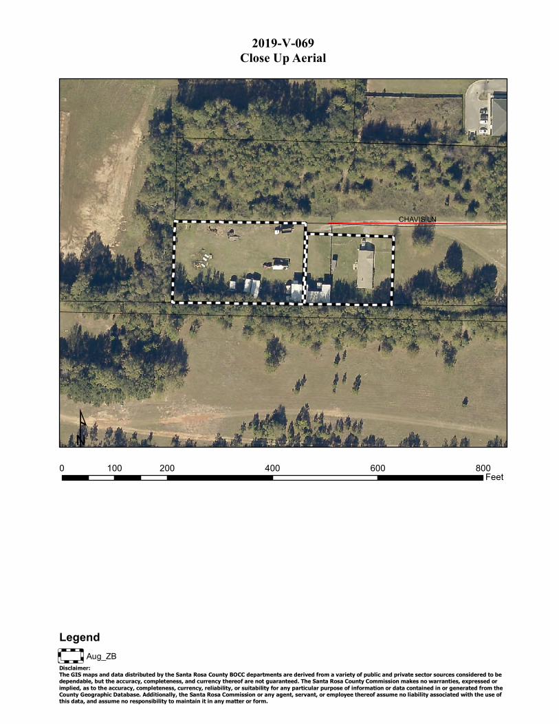
C 2019-V-069lose Up Aerial
CHAVIS LN
¹ 0 100 200 400 600 800
Feet
Legend Aug_ZB
Disclaimer:The GIS maps and data distributed by the Santa Rosa County BOCC departments are derived from a variety of public and private sector sources considered to be dependable, but the accuracy, completeness, and currency thereof are not guaranteed. The Santa Rosa County Commission makes no warranties, expressed or implied, as to the accuracy, completeness, currency, reliability, or suitability for any particular purpose of information or data contained in or generated from the County Geographic Database. Additionally, the Santa Rosa Commission or any agent, servant, or employee thereof assume no liability associated with the use ofthis data, and assume no responsibility to maintain it in any matter or form.

Ex 2019-V-069
isting Land Use
VINEWOOD LN
WO
OD
BIN
ER
D
CHAVIS LN
ARGYLE DR
POP
AG
SFR
VACANT
AG
ROW
VACANT
SILVICUL
OFFICE
ROW
SFR
SFR
OFFICE
VACANT
MRC
SFR
AG
VACANT
VACANT
¹ 0 200 400
Legend Aug_ZB
Existing Land UseCategory
Agriculture (AG)
Agriculture, Homestead (AH)
Condo's/Townhomes (C/T)
City
Commercial (COMM)
Industrial (INDUS)
800 1,200
Institutional (INST)
Multi-Family Residential (MFR <5)
Multi-Family Residential (MFR >5)
Military (MIL)
Mixed Residential/Commercial (MRC)
Office
Public Owned Property (POP)
Rail
Recreation/Commercial (REC/COMM)
1,600Feet
Recreation/Open Space (REC/OS)
Right of Way (ROW)
Single Family Residential (SFR)
Silviculture (SILVICUL)
Uncategorized (UNCAT)
Utilities
Vacant
Water
Disclaimer:The GIS maps and data distributed by the Santa Rosa County BOCC departments are derived from a variety of public and private sector sources considered to bedependable, but the accuracy, completeness, and currency thereof are not guaranteed. The Santa Rosa County Commission makes no warranties, expressed orimplied, as to the accuracy, completeness, currency, reliability, or suitability for any particular purpose of information or data contained in or generated from theCounty Geographic Database. Additionally, the Santa Rosa Commission or any agent, servant, or employee thereof assume no liability associated with the use ofthis data, and assume no responsibility to maintain it in any matter or form.
1111 1111 1111 1111 1111 1111
1111 1111 1111 1111 1111 EI] . 1111 1111 1111 1111 1111 1111 8883 1111 1111 1111

2019-V-069Previous Zoning Board Decisions in the Area
_̀
VINEWOOD LN
WO
OD
BIN
ER
D
CHAVIS LN
ARGYLE DR
2016-V-043
2002-R-009 No Conditions
2003-R-027 No Conditions
2004-R-024 No Conditions
2005-R-027 No Conditions 2005-R-027
No Conditions
2019-R-001 1992-R-021
2002-R-032¹ 0 200 400 800 1,200 1,600
Feet
Legend
Disclaimer:
Aug_ZB
Approved Rezonings
Denied Withdrawn Rezonings
The GIS maps and data distributed by the Santa Rosa County BOCC departments are derived from a variety of public and private sector sources considered to bedependable, but the accuracy, completeness, and currency thereof are not guaranteed. The Santa Rosa County Commission makes no warranties, expressed orimplied, as to the accuracy, completeness, currency, reliability, or suitability for any particular purpose of information or data contained in or generated from theCounty Geographic Database. Additionally, the Santa Rosa Commission or any agent, servant, or employee thereof assume no liability associated with the use ofthis data, and assume no responsibility to maintain it in any matter or form.
I I ~
~
L
,-----1 I ·----J [ICJII

Looking at the adjacent parcel to the north, subject site is to our left
64
Looking west subject site is behind us, the building on the right of the photo is the Babcocks.
65
Looking south, subject site is to our right
66
Looking into the subject site.
67


tp.OS4e,_'-,
!/;~"' . . · .~'""~ SANTA ROSA COUNTY . . DEVELOPMENT SERVICES ~0~ 6051 Old Bagdad Highway, Suite 202 I Milton, Florida 32583
SHAWN WARD Planning and Zoning Director [email protected]
Variance Application * Application Instructions begin on Page 3
** For Official Use Only** Application No. cAO\q -V - Otp,9 Date Received: Mlf7 't U 1(1.JJ
Review Fee: a35 t ~ . ':\D Recelpt No.: _:3~0_'1~J,__ ___ _ _ Zoning District: Hc-D FLUM DesiQnation: CO mm
+, _ /. 0 9 _ Cb~ I
Property Property Owner Name: ~~4 ~ 'r ~ /e_~ou...!JYl. : t½f( Owner // \.j
Address: , 5.34 3 ~ ~v 1 -~ -<. !"k1£,,,
Phone: /?fe-~-~539 Fax:,?~- 99':;-- Z"f?)o
Email: ➔ n1 t /,,t ~ IJ~ /J.S eu ¾ . ffe '!-
Applicant [i]'check here and skip this section if the applicant is the Property Owner. Otherwise, complete this section and provide authorization from the Property Owner giving the Applicant the authority to pursue variance approvals.
Company: _ _ ________________ ___ _
Contact Name: ____________________ _
.Address: ______ _______ ~ ---------
Phone: t:f.5cr .j;(, -D:[":qtj Fax: £.jZ> - 9££- ~.,foo I)
Email: L(wt lf:ll @. /2£1/::fou.U. )Jcr
Property Parcel ID Number(s):D~ IN J,</ oocoooS-o t,c:co04-Dt:,/iJ 2,9oax.::a:6o/ C>C1.JO Information •OR·
Street Address of property for which the Variance is requested:
Office: 850.981.70751 Fax: 850.983.9874 I www.santarosa.fl.gov

What is the present use of the property? K£..1v ML -:YhtP() - sf~e~ Variance Request
Please describe the requested variance, including exact dimension~ and purpose of the variance.
--re -Re~&£ '-~Jse,p,p£- buf&tL: ]::"';u,.,.,,. c2£J '~µ,f+µL ~ s/ Dl.t. .P~L ro r;?,u .. il .. if1r~*~ tt't!C£Ssiblih To m10J£ui~ttbt'41-v ~v ~A-,·u,2..s
,N4P 72v s:~s Please describe the special circumstances or conditions that apply to the building or land in questions which necessttate the variance request.
~ AJ-J-A~exrr l.;,rr.oc;:,.,0ilE-~ fri1- f+<u/soN, hi1'5 ,.Jh ftl!.£,11 /,,is i 11+ t! rrb~n -lo ~kn'1i=-~ ~ ~\le.A -r 'ZoA : IJ 1; to (?..e, IY\. M£IU ~ £/.Sf' w,A;.. c. '1. ,.,._, ,o 4. l</ tc IL.4,w '1k
f«~u.~ e--lt twip- /;t.c, (fl ofo I --k>.S: fn ~ fo/4 d sz:,,.J tftS NO ohtEC! ./ro,1 'fl) 'fP,i S
Are the special conditions or circumstances described above the result of a proposed or prior action Vii' ,:2...; ft' A..Jce-of the applicant? Yes__ No~
Pleas explain why the literal enforcement of the provisions of the Land Development Code will result in unnecessary hardship.
Z,,,,t!--,l '1?11-5; -k ~j&. ;fl?(2q1/l£- /lp/Jft:ON.'MPrldy ~ to /,2 ~es~ µc;,rt.<f-CL. e:,~
~ · "-d A- fu v&'-7A-H·;} u.. ~ .vb tt .J-/-;mdNZo /cl ' k.->~:f e. Fv s, ~ Ju; JJoN CoM CV\,£.µc.lL Jit~ vu.~ ef- ,tt;_l Af£:S
Variance Provisions
And Criteria
Do you currently have a Code Enforcement Violation which pertains to this Variance request?
I understand that all decisions made by the Zoning Board of Adjustment are subject to appeal and that their decision does not become effective until the appeal time has successfully passed.
I understand that approval by the Zoning Board of Adjustments does not authorize construction and/or land clearing to occur on this site and that additional approvals and Building Perrntts may be required.
I understand that determinations by the Zoning Board of Adjustment are valid for 36 months.
Certification and Authorization
□ Yes IJrl(c(
~□No
~ □No ~□No
By my signature hereto, I do hereby certify that the information contained in this application and the required supplemental materials is true and correct, and understand that deliberate misrepresentation of such information will be grounds for denial or reversal of this application and/or revocation of any approval based upon this applicatio . o hereby authorize County staff to enter upon my property at any reasonable time for purposes of stte inspection.
f:1,e ... T /µ, t3 Y'C>4--n 1 ~ J Applicant Name (Type or Print)
Title (if applicable)
Variance Application
Date
X:Unterdepartmental-files\Development Services\PZ Applications\2018 Applicalions\Variance.doc
--
Page2of 4 Revised June 12, 2018

1· 30'
i,,,,-0000
_ ' OF COMMENCEMENT ~ A &: PARCEt. B & A z.t' WIDE ~ &: EGRESS EASEME1'-"T !Sr ccw.Ut or nc sou"" 11...v or n< !AU' Of' TMlt NOll~Sl WAlllftlt 0, M; 1$fQIJ1,~~0IKCTCt4$, TOM,1~ 1 IU,f!OC tt K'Sl. 5,..,11, M)S.I, 00UIHY,
CEND: ~ ffiilotY.J'd rfl,lto,,M,YN~
Q( ou,g,u~wauc
""'°'u~~~ DtJ,IO'lllf"OT(UVJJIIJH$
-fftWUMY"U'f
DO,Otd'lllf-"'
~ ot:'°'U'1'l)j011Q'I
C=:! 'Ml'OW0~1'f'1,•'fMU,,
~ ~Daitl('Jlf"'flPIIO
ffil. , .. Qrff ..... :,,GW'tt,,l(KU!'if
1051, UAAelllWl'lliM'19o\Of U)tl
POINT or 0£GINNlNG (20° .-11>!! INGRESS/ECkt:SS EA!F.l,U::HT) It A ◄' 11'U)I: ?fGRESS/ECRtSS t:A.!EW.Ef,,"f l"CN'Jl'lOIIC)t,IAP[
~=01'2)
A SAND CHIMNEY DETAILS AND POND •s• X-SECT CJ CJ
@IO'ltV<SSIIIICIIIM?N..llllJOOlm.l(l)-S,-.cu..111.f •OQGl(flEOIIIINJ. .. tll<~-:V IOffllf'!"'INIOl'll:illl/llll Olll(,lr;t-..;WIOl'ltltXPD:IEJ$10WitLl~r.utfD,.Cl'Q.
(D SIIQII.O IOl-!Ml.l~M..._.C..Cornl'< w-im: 11J1mi0.2•~• f!:....,,ceft:IINI' IMl!IU#6•_t I ~M:fl/lt&tSO</fil_lm_lllMl
<D =~J.~:~~~V:.S'=-.':,I0St11D,.::;..11.;f, ~ff'Jffllllll'IW I IW .... Cl-.J.lllllCO':f1'4-U.l~~NIGr CDIWOO!t«Dllff-,UltJllliltUU:O~
@ MIOIOSl!DINJ..11:a.ll l WflfiOIO~~CIIIS$GIIOIPl~l'U--G:IJ
............... , ~~;:r..2'H,lr
- -ii I ~ ~ ~ t~ ;a ~~ ~-- ~ ij ~ 0~ ~· ~ t~ =r.. l: r ~ -~ ~ ~e ~
O,.Tl: 07-
SCAl.f:: l "•
SHUT NlMt
(


Sales In Area Sales In Section
Sales In Subdivision Previous Parcel Next Parcel Field Definitions Return to Main Search Santa Rosa Home
Owner and Parcel Information
Owner Name BROWNING ROBERT W & HELEN GAYLE Today's Date June 14, 2019
Mailing Address P O BOX899 Parcel Number 06-1N-29-0000-00501-0000
MILTON, FL 32572 Tax District Pace (District 22)
Situs/Physical Address CHAVIS LN PACE 2018 Millage Rates 12.4281
Property Usage VACANT COM (001000) Acreage 0.99
Section Township Range 06-1N-29 Homestead N
Value Information Legal Description
COM SW COR OF S2 OF N2 OF NE4 OF NE4 THN E 460 FT TO POB THNN 165 FT THN E 264 FT THN S 165 FT THN W 264 FT TO POB TOGETHER WITH ESMNT FOR
INGRESS/EGRESS AS DES IN OR 2468 PG PG 146 & OR 2473 PG 612 (*NOTE: THERE IS A 3 FT GAP BETWEEN THIS & PRCL #5.2) SUBJ TO EASMT IN OR 3560
PG 1511 & TOGETHER WITH EASMTS INOR 3560 PGS 1515 & 1520
2016 Certified Values 2017 Certified Values 2018 Certified Values
Building Value $0 $0 $0
Extra Feature Value $0 $0 $0
Land Value $36,655 $36,655 $36,655
Land Agricultural Value $0 $0 $0
Agricultural (Market) Value
$0 $0 $0
Assessed Value $36,655 $36,655 $36,655
Exempt Value $0 $0 $0
Taxable Value $36,655 $36,655 $36,655
Just (Market) Value* $36,655 $36,655 $36,655
The legal description shown here may be condensed for assessment purposes. Exact description should be obtained from the recorded deed.
"Just (Market) Value" description - This is the value established by the Property Appraiser for ad valorem purposes. This value does not represent anticipated selling price.
Extra Features Data
Description Number of Items Units Year Extra Feature Value
No records associated with this parcel.
Land Information
Item Land Code Description Zoning Frontage Depth Unit Type Land Units Land Value
1 001000 COMMERCIAL HCD 260 165 43124.4 SF $36,655
Sale Information
Multi-Parcel Sale
Sale Date
Sale Price
Instrument Deed Book
Deed Page
Sale Qualification
Vacant or Improved
Grantor Grantee
No 06-14-2005
$ 65,000 Warranty Deed 2468 146 Qualified Vacant BURKLOW STEVE & HENDERSON BRYAN
BROWNING ROBERT W & HELEN GAYLE
No 09-02-2004
$ 33,000 Warranty Deed 2351 1351 Qualified Vacant LEWIS BILL A & TRACEY S BURKLOW STEVE & HENDERSON BRYAN
No 06-14-2004
$ 100 Quit Claim
Deed 2473 612 Unqualified Vacant BROWNING ROBERT W &
BROWNING ROBERT W & HELEN G
No 04-01-1998
$ 23,500 Warranty Deed 1680 1379 Unqualified Improved LEWIS BILL A & TRACEY S
No 06-01-1996
$ 100 Warranty Deed 1560 1274 Unqualified Improved BRYANT JOHNNY L & VEDA M BURKLOW STEVE &
No 08-01-1988
$ 100 Warranty Deed 968 375 Unqualified Improved CHAVIS CHARLIE & WILLIE MAE BRYANT JOHNNY L & VEDA M
Sales In Area Sales In Section
Sales In Subdivision Previous Parcel Next Parcel Field Definitions Return to Main Search Santa Rosa Home
The Santa Rosa County Property Appraiser's Office makes every effort to produce the most accurate information possible. No warranties, expressed or implied, are provided for the data herein, its use or interpretation. The Senior Exemption Does Not Apply to All Taxing Authorities. Just (Market) Value is established by the Property Appraiser for ad valorem tax purposes. It does not represent anticipated selling price. Working values are subject to change. Website Updated: June 12, 2019
© 2011 by the County of Santa Rosa, FL | Website design by qpublic.net
- y..O S.I\ Co
TRIM N,:,tic~
I
I
Santa Rosa County Property Appraiser
Gregory S. Brown, CFA
ax Collector Bill
I I I
- -
- -
- -
- -
- -
- -
I
Show Zonin

Sales In Area Sales In Section
Sales In Subdivision Previous Parcel Next Parcel Field Definitions Return to Main Search Santa Rosa Home
Owner and Parcel Information
Owner Name BROWNING ROBERT W & HELEN G Today's Date June 14, 2019
Mailing Address P O BOX899 Parcel Number 06-1N-29-0000-00502-0000
MILTON, FL 32572 Tax District Pace (District 22)
Situs/Physical Address 3363 CHAVIS LN PACE 2018 Millage Rates 12.4281
Property Usage SFRES/COMM (000110) Acreage 0.55
Section Township Range 06-1N-29 Homestead N
Value Information Legal Description
2016 Certified Values 2017 Certified Values 2018 Certified Values
Building Value $76,983 $80,166 $87,045
Extra Feature Value $1,002 $1,002 $1,002
Land Value $20,364 $20,364 $20,364
Land Agricultural Value $0 $0 $0 COM SW CORN S2 N2 NE4 NE4 TH S89*20'01"E 727 FT TO POB TH N0*39'59"E 145 FT TH S89*20'01"E 165 FT TH S0*39'59"W 145 FT TH N89*20'01"W 165 FT TO POB ALG &
Just (Market) Value* $98,349 $101,532 $108,411
Assessed Value $98,349 $101,532 $108,411
Exempt Value $0 $0 $0
Taxable Value $98,349 $101,532 $108,411
Agricultural (Market) Value $0 $0 $0 TOG W 20 FT ING/EGR ESMNT ALL AS SDES IN OR 2471 PG 510 & 2473 PG 612 & OR 2613 PG 325 (*NOTE: THERE IS A 3 FT GAP BETWEEN THIS & PARCEL #5.1)
The legal description shown here may be condensed for assessment purposes. Exact description should be obtained from the recorded deed.
"Just (Market) Value" description - This is the value established by the Property Appraiser for ad valorem purposes. This value does not represent anticipated selling price.
Extra Features Data
Description Number of Items Units Year Extra Feature Value
FIREPLACE 1 1 UT 1982 $1,000
SHED 1 2 UT 2007 $2
Land Information
Item Land Code Description Zoning Frontage Depth Unit Type Land Units Land Value
1 001000 COMMERCIAL HCD 145 165 23958 SF $20,364
Sale Information
Multi-Parcel Sale
Sale Date
Sale Price
Instrument Deed Book
Deed Page
Sale Qualification
Vacant or Improved
Grantor Grantee
No 06-14-2005
$ 125,000
Warranty Deed 2471 510 Qualified Improved BURKLOW STEPHEN A & HENDERSON
BRYAN D & GAVIN BROWNING ROBERT W &
HELEN GAYLE
No 05-23-2005
$ 100 Warranty Deed 2471 504 Unqualified Improved SMITH DURWOOD T BURKLOW STEPHEN ALLEN
ET AL
No 06-14-2004
$ 100 Quit Claim Deed 2473 612 Unqualified Improved BROWNING ROBERT W & HELEN G BROWNING ROBERT W &
HELEN G
No 06-30-2003
$ 33,000 Quit Claim Deed 2169 1675 Unqualified Improved SMITH MELBA L SMITH DURWOOD T
No 06-30-2003
$ 90,000 AGREEMENT FOR
DEED 2169 1677 Qualified Improved SMITH DURWOOD T
BURKLOW STEPHEN ALLEN ET AL
No 04-01-1995
$ 100 Warranty Deed 1468 353 Unqualified Improved
No 04-01-1995
$ 67,000 Warranty Deed 1468 358 Qualified Improved SMITH DURWOOD T & MELBA
L
No 05-01-1978
$ 100 Warranty Deed 439 749 Unqualified Vacant
Sales In Area Sales In Section
Sales In Subdivision Previous Parcel
The Santa Rosa County Property Appraiser's Office makes every effort to produce the most accurate information possible. No warranties, expressed or implied, are provided for the data herein, its use or interpretation. The Senior Exemption Does Not Apply to All Taxing Authorities. Just (Market) Value is established by the Property Appraiser for ad valorem tax purposes. It does not represent anticipated selling price. Working values are subject to change. Website Updated: June 12, 2019
Next Parcel Field Definitions Return to Main Search Santa Rosa Home
© 2011 by the County of Santa Rosa, FL | Website design by qpublic.net
Santa Rosa County Property Appraiser
Gregory S. Brown, CFA
I