2017 Drury-Mincy Conservation Area Management Plan Drury Mincy...2017 Drury-Mincy Conservation Area...
14
Transcript of 2017 Drury-Mincy Conservation Area Management Plan Drury Mincy...2017 Drury-Mincy Conservation Area...
2017 Drury-Mincy Conservation Area Management Plan Page 3
OVERVIEW
• Official Area Name: Drury-Mincy Conservation Area, #5401 • Year of Initial Acquisition: 1987 • Acreage: 5599 acres; 1,510 acres owned by the U.S. Army Corps of Engineers (USACE) on
Bull Shoals Lake • County: Taney • Division with Administrative Responsibility: Wildlife • Division with Maintenance Responsibility: Wildlife, Design and Development (roads and
infrastructure) • Statements of Purpose:
A. Strategic Direction Manage for multiple resource uses and recreational opportunities with an emphasis on wildlife management through natural community restoration and maintenance.
B. Desired Future Condition The desired future condition of Drury-Mincy Conservation Area (CA) is a healthy and diverse glade/woodland complex, with interspersed high quality green browse food plots. Riparian corridor enhancement and stream bank stabilization using giant cane (Arundinaria gigantean) restoration and bottomland hardwood plantings along Bee Creek from Gunnison Road to Bull Shoals Lake is also desired.
C. Federal Aid Statement N/A
GENERAL INFORMATION AND CONDITIONS
I. Special Considerations A. Priority Areas: Drury Mincy Hills Terrestrial Conservation Opportunity Area,
Drury Mincy Dissected Plains Terrestrial Conservation Opportunity Area, Priority Forest Landscape
B. Natural Areas: None C. Other: Bee Creek riparian corridor giant cane is an imperiled habitat for
neotropical migrant songbirds.
II. Important Natural Features and Resources A. Species of Conservation Concern: Species of conservation concern are known
from this area. Area managers should consult the Natural Heritage Database annually and review all management activities with the natural history biologist.
B. Caves: Yes, records kept with Missouri Department of Conservation (the Department) natural history biologist. Managers should follow the Cave Management policy found in the Department Resource Policy Manual. All caves
2017 Drury-Mincy Conservation Area Management Plan Page 4
on this and other Conservation Areas are closed or restricted to public access. The fungus that causes White-nose Syndrome in bats has been documented in Missouri, resulting in the Department’s White-nose Syndrome Action Plan that limits public access to protect bats.
C. Springs: Yes, records kept with Department Natural History Biologist. D. Intermittent Streams: Fox Creek (0.5 miles), Bee Creek (3 miles), Mincy Creek
(3 miles)
III. Existing Infrastructure • 6 gravel parking lots • Bear Cave Trail (hiking, 1.5 miles) • Thurman’s Sink Trail (hiking, 0.3 miles) • Mincy Camping Area (8 campsites with fire rings and picnic tables) • 6-target field archery range • Privy • Area buildings: grain bin, bunkhouse, 2 chemical storage sheds, storage building,
pump house, equipment shop and storage
IV. Area Restrictions or Limitations A. Deed Restrictions or Ownership Considerations: 1,510 acres of the area are
owned by the U.S. Army Corps of Engineers (USACE) and leased to the Department under a 25-year lease agreement (dated 9/1/2013); Missouri State University Bull Shoals Field Station is located on a 5-acre portion of USACE land, with research occurring on all of the conservation area
B. Federal Interest: Federal funds may be used in the management of this land. Fish and wildlife agencies may not allow recreational activities and related facilities that would interfere with the purpose for which the State is managing the land. Other uses may be acceptable and must be assessed in each specific situation.
C. Easements: None D. Cultural Resources Findings: Yes, records kept with Department environmental
compliance specialist. Managers should follow Best Management Practices for Cultural Resources found in the Department Resource Policy Manual.
E. Endangered Species: Endangered Species are known from this area. Area Managers should consult the Natural Heritage Database annually and review all management activities with the natural history biologist.
F. Boundary Issues: Establishing accurate and identifiable boundary markers is a priority for this property.
2017 Drury-Mincy Conservation Area Management Plan Page 5
MANAGEMENT CONSIDERATIONS
V. Terrestrial Resource Management Considerations
Drury-Mincy CA contains over 5,400 acres of glade/woodland habitat with some forested pockets of poor quality timber. The area is primarily managed to enhance glade and woodland natural communities. Management tools such as prescribed fire, herbicide and mechanical thinning are the primary tools. Additionally, a forest inventory to collect overstory data is planned for FY18. The area has been divided into 11 management units (Figure 3). The area also includes over 150 acres of high quality green browse food plots, planted on annual rotations with small grain crops and perennial legumes.
Challenges and Opportunities: 1) Improve wildlife habitat and native plant diversity by limiting the spread of
invasive plant species. 2) Expand prescribed fire timing and frequency. 3) Conduct population census for deer.
Management Objective 1: Maintain and improve native plant diversity by reducing invasive plant species.
Strategy 1: Monitor glades and woodlands for invasive exotic vegetation. Treat any infestations that may develop. (Wildlife) Strategy 2: Search for biological control methods to be used in place of chemical control. (Wildlife, Resource Science) Strategy 3: Monitor field and road edges as well as stream banks for invasive plant encroachment. (Wildlife)
Management Objective 2: Increase plant and natural community diversity by varying season of prescribed fires.
Strategy 1: Vary prescribed burns in glades and open woodlands between dormant and growing seasons to enhance native forb and grass species diversity and reduce woody sapling encroachment. Avoid burns in riparian corridor and bottomland forests between May 1- June 30 to address species of conservation concern needs.(Wildlife) Strategy 2: Reduce burn frequency in prescribed units that have reached a maintenance phase increase frequency in prescribed units that are in a restoration phase. (Wildlife) Strategy 3: Conduct a forest inventory and establish permanent vegetative plots in all forest and woodland landscapes to assist managers in future regeneration techniques. (Forestry, Wildlife)
2017 Drury-Mincy Conservation Area Management Plan Page 6
Management Objective 3: Obtain annual deer population census data to manage habitat for deer as a focal species.
Strategy 1: Manage deer population numbers by statewide archery methods. Use annual deer census data, Telecheck monitoring (if feasible), and managed hunts to refine deer harvest as necessary to meet goals. (Wildlife, Administrative Services, Resource Science) Strategy 2: Manage open and forested habitats appropriately for deer utilizing supplemental small grain and green browse plots, forest thinning, and prescribed fire. (Wildlife, Forestry) Strategy 3: Continue to develop deer management and population goals for the area using census data and harvest reports. (Wildlife, Resource Science, Administrative Services)
VI. Aquatic Resource Management Considerations
Challenges and Opportunities 1) Manage fisheries and watershed. 2) Stabilize stream bank and enhance riparian area.
Management Objective 1: Improve stream bank stability and functionality of riparian corridor along Bee Creek.
Strategy 1: Continue transplanting giant cane along riparian zones to improve soil structure and stream bank stability; and provide critical habitat for neotropical migrant songbirds and habitat for small mammals. (Wildlife) Strategy 2: Annually plant willow trees or bottomland hardwoods in exposed stream banks and flood areas to minimize erosion. Also, look for potential areas to widen riparian corridors. (Wildlife, Forestry)
Management Objective 2: Manage the area in ways which minimize the supply and transport of sediments, gravel or pollutants into downstream areas. Follow Watershed and Stream Management Guidelines for Land and Waters Managed By Missouri Department of Conservation” (Missouri Department of Conservation, 2009).
Strategy 1: Minimize any adverse impacts to the watershed by observing protection measures during any disturbance in the riparian zones. (Wildlife) Strategy 2: Use appropriate herbicides when controlling invasive species in the riparian zones. Maintain existing riparian corridor. (Wildlife) Strategy 3: Consult Fisheries on all work inside the riparian corridors. (Wildlife) Strategy 4: Control erosion along the road and trail system. (Wildlife)
2017 Drury-Mincy Conservation Area Management Plan Page 7
VII. Public Use Management Considerations
Challenges and Opportunities: 1) Provide for hunting and viewing opportunities. 2) Build relationships with neighboring landowners. 3) Enhance recreational opportunities to adjust to growing Taney County population.
Management Objective 1: Provide public hunting and viewing opportunities. Strategy 1: Conduct annual management activities that will provide habitat for a diversity of species. (Wildlife) Strategy 2: Publicize small game, deer, and turkey hunting opportunities at Drury-Mincy CA. (Wildlife, Outreach and Education)
Management Objective 2: Facilitate good working relationships with neighboring landowners, and Missouri State University Bull Shoals Field Station.
Strategy 1: Work with neighbors to minimize boundary, trespass, or any other issues affecting Drury-Mincy CA or private property. (Wildlife, Protection) Strategy 2: Promote habitat management and invasive species control on neighboring landowner properties. (Private Land Services) Strategy 3: Coordinate management activities with Missouri State University Bull Shoals Field Station personnel research projects.
Management Objective 3: Expand and enhance recreational opportunities on Drury-Mincy CA.
Strategy 1: Communicate recreational opportunities to the public (e.g., using brochures, Atlas database). (Wildlife) Strategy 2: Improve and expand if feasible, existing walking/hiking trails and promote the use of Drury-Mincy CA as an outdoor classroom to local high schools, universities and non-governmental organizations. (Wildlife, Outreach and Education) Strategy 3: Update and maintain existing campground facilities, as needed. (Wildlife)
VIII. Administrative Considerations
Challenges and Opportunities: 1) Maintain area infrastructure, or remove unnecessary infrastructure. 2) Acquisition of land. 3) Maintain or post property boundaries. With the increasing land prices in
Taney County, accurate boundary postings are increasingly important.
2017 Drury-Mincy Conservation Area Management Plan Page 8
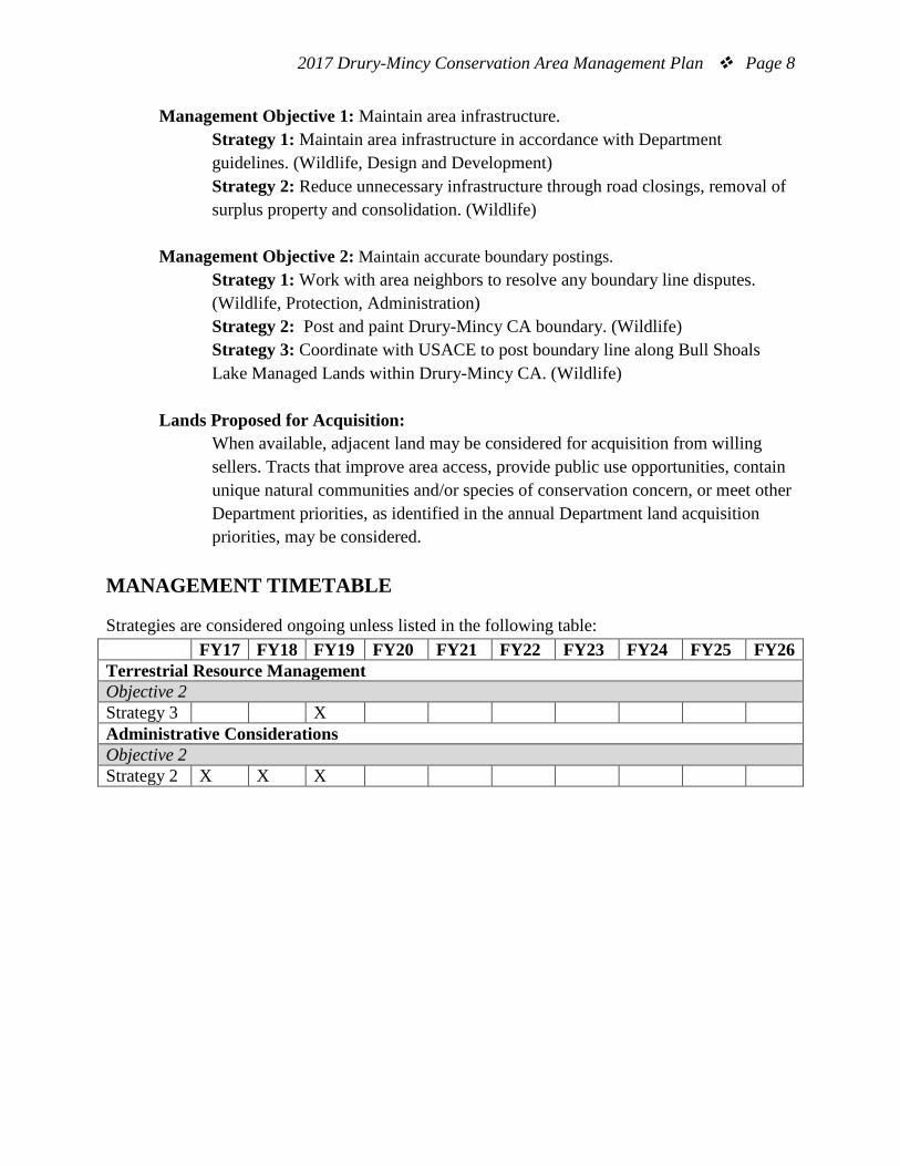
Management Objective 1: Maintain area infrastructure. Strategy 1: Maintain area infrastructure in accordance with Department guidelines. (Wildlife, Design and Development) Strategy 2: Reduce unnecessary infrastructure through road closings, removal of surplus property and consolidation. (Wildlife)
Management Objective 2: Maintain accurate boundary postings. Strategy 1: Work with area neighbors to resolve any boundary line disputes. (Wildlife, Protection, Administration) Strategy 2: Post and paint Drury-Mincy CA boundary. (Wildlife) Strategy 3: Coordinate with USACE to post boundary line along Bull Shoals Lake Managed Lands within Drury-Mincy CA. (Wildlife)
Lands Proposed for Acquisition: When available, adjacent land may be considered for acquisition from willing sellers. Tracts that improve area access, provide public use opportunities, contain unique natural communities and/or species of conservation concern, or meet other Department priorities, as identified in the annual Department land acquisition priorities, may be considered.
MANAGEMENT TIMETABLE
Strategies are considered ongoing unless listed in the following table: FY17 FY18 FY19 FY20 FY21 FY22 FY23 FY24 FY25 FY26 Terrestrial Resource Management Objective 2 Strategy 3 X Administrative Considerations Objective 2 Strategy 2 X X X
2017 Drury-Mincy Conservation Area Management Plan Page 9
APPENDICES
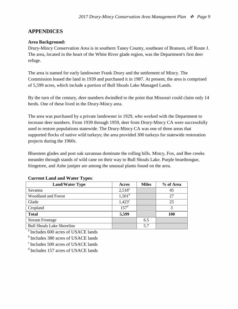
Area Background: Drury-Mincy Conservation Area is in southern Taney County, southeast of Branson, off Route J. The area, located in the heart of the White River glade region, was the Department's first deer refuge. The area is named for early landowner Frank Drury and the settlement of Mincy. The Commission leased the land in 1939 and purchased it in 1987. At present, the area is comprised of 5,599 acres, which include a portion of Bull Shoals Lake Managed Lands. By the turn of the century, deer numbers dwindled to the point that Missouri could claim only 14 herds. One of these lived in the Drury-Mincy area. The area was purchased by a private landowner in 1929, who worked with the Department to increase deer numbers. From 1939 through 1959, deer from Drury-Mincy CA were successfully used to restore populations statewide. The Drury-Mincy CA was one of three areas that supported flocks of native wild turkeys; the area provided 300 turkeys for statewide restoration projects during the 1960s. Bluestem glades and post oak savannas dominate the rolling hills. Mincy, Fox, and Bee creeks meander through stands of wild cane on their way to Bull Shoals Lake. Purple beardtongue, fringetree, and Ashe juniper are among the unusual plants found on the area. Current Land and Water Types:
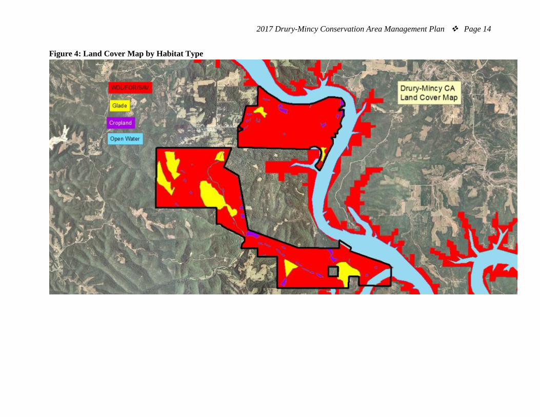
Land/Water Type Acres Miles % of Area Savanna 2,518a 45 Woodland and Forest 1,501b 27 Glade 1,423c 25 Cropland 157d 3 Total 5,599 100 Stream Frontage 6.5 Bull Shoals Lake Shoreline 5.7 a Includes 600 acres of USACE lands b Includes 380 acres of USACE lands c Includes 500 acres of USACE lands d Includes 157 acres of USACE lands
2017 Drury-Mincy Conservation Area Management Plan Page 10
Public Input Summary: The draft Drury-Mincy Conservation Area Management Plan was available for public comment period April 1-30, 2016. The Missouri Department of Conservation received no comments during this time period. References: Missouri Department of Conservation. (2009). Watershed and stream management guidelines for
lands and waters managed by Missouri Department of Conservation. Jefferson City, Missouri: Missouri Department of Conservation.
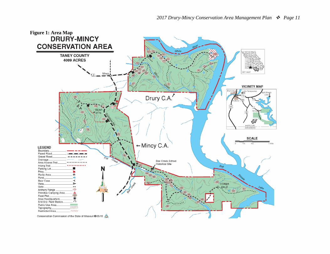
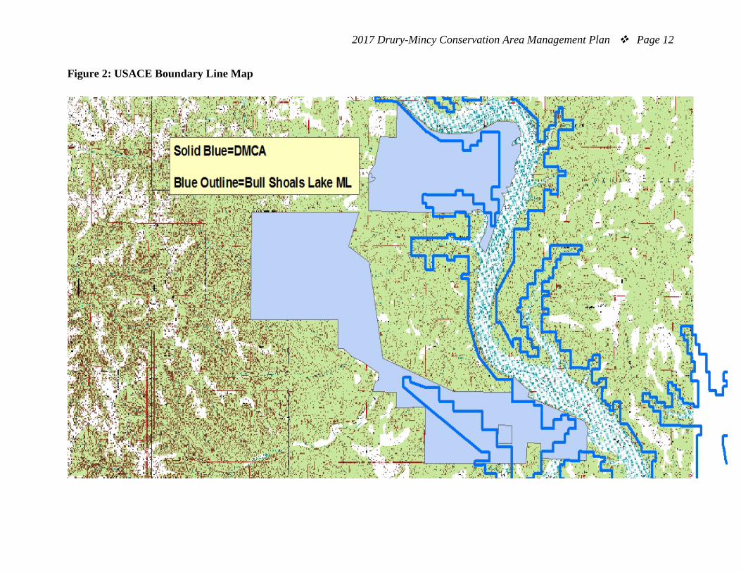
Maps: Figure 1: Area Map Figure 2: USACE Boundary Line Map Figure 3: Prescribed Burn Units Map Figure 4: Land Cover Map by Habitat Type
2017 Drury-Mincy Conservation Area Management Plan Page 11
Figure 1: Area Map
2017 Drury-Mincy Conservation Area Management Plan Page 12
Figure 2: USACE Boundary Line Map
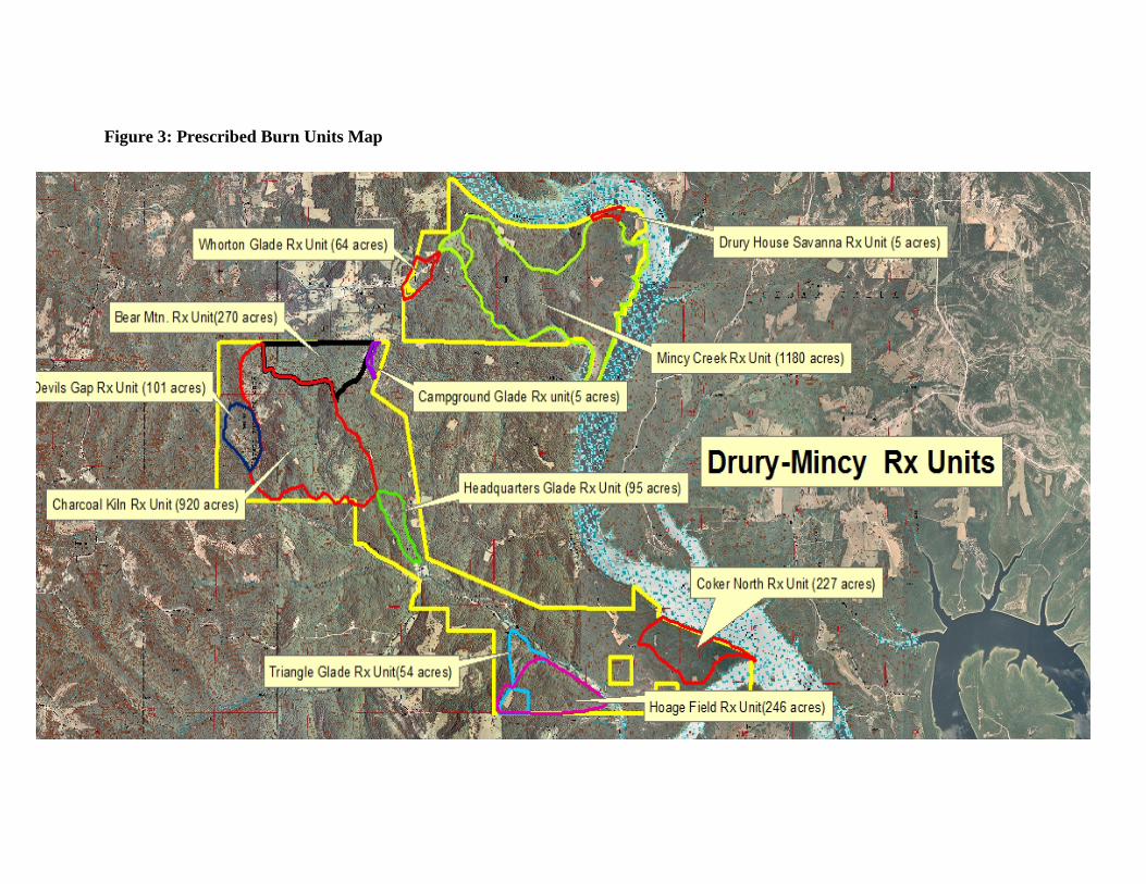
Figure 3: Prescribed Burn Units Map
2017 Drury-Mincy Conservation Area Management Plan Page 14
Figure 4: Land Cover Map by Habitat Type