2016 conservation track: geospatial and temporal population analysis of shortgrass prairie birds as...
38
Geospatial and Temporal Population Analysis of Shortgrass Prairie Birds as a STEM Community Service Project Kathryn de Venecia
-
Upload
gis-in-the-rockies -
Category
Technology
-
view
49 -
download
0
Transcript of 2016 conservation track: geospatial and temporal population analysis of shortgrass prairie birds as...

Geospatial and Temporal Population Analysis of Shortgrass Prairie Birds as a STEM Community Service Project
Kathryn de Venecia

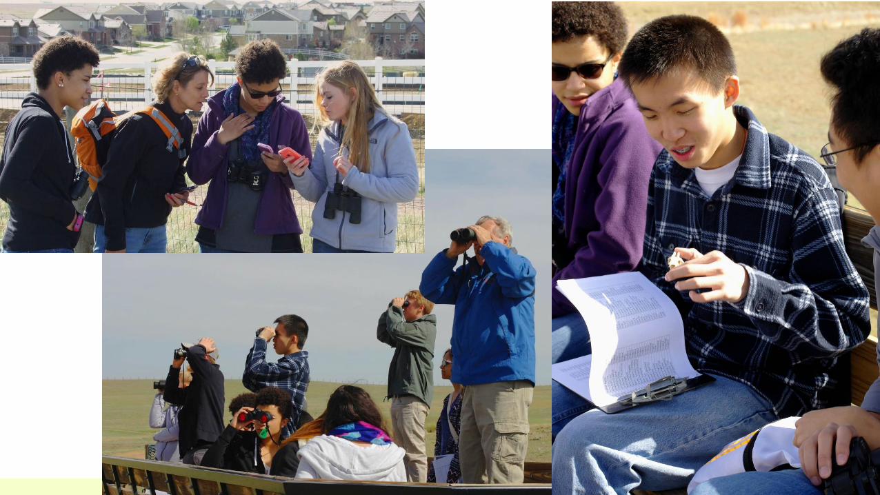
Citizen Science Project: Plains Conservation Center and
Eaglecrest High School Science National Honor Society

Objectives1. Spreadsheet development and data entry: from monthly bird counts
(2008 to 2015)
2. Species categorization: of 89 species based on sightings as:
•year-round resident
•summer resident
•winter resident
•migrant or "occasional" sighting
3. Population trends analysis: for key bird species and groups based on site data, to identify possible population trends
4. Strategies management: to help support and/or increase specific key species and groups

Site Characteristics Residential Encroachment
• Eastern edge of Rocky Mountains
• Shortgrass Prairie Ecosystem
• Aurora, Colorado
• 1100-acre site
• Unique Observation Points
• Increasing to the west, south, and northeast
• Throughout data collection from 2008 to 2015

Spreadsheet Development
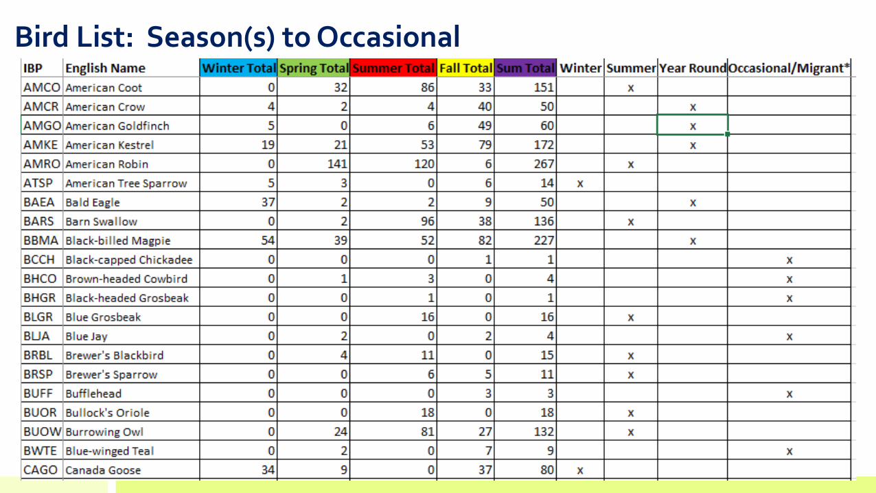
Bird List: Season(s) to Occasional
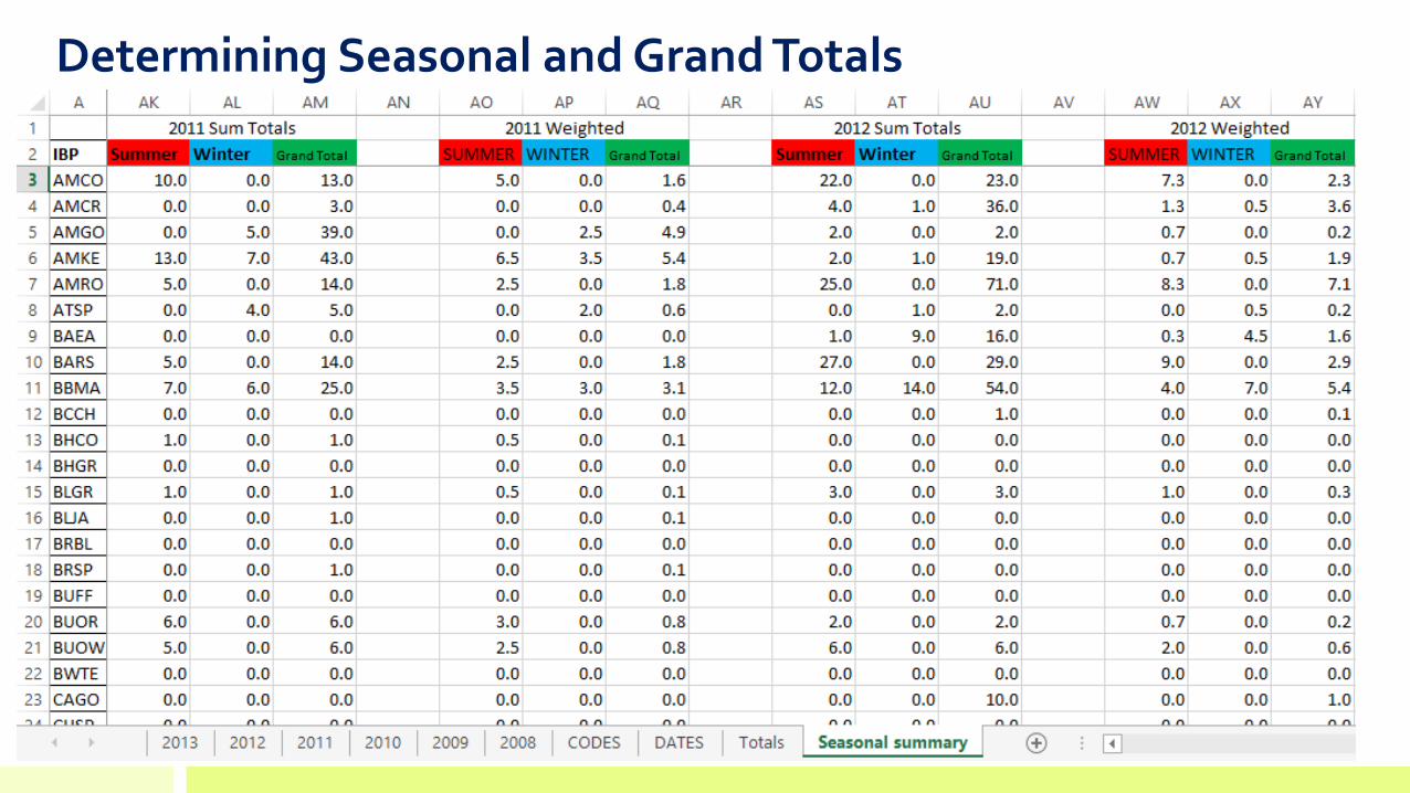
Determining Seasonal and Grand Totals

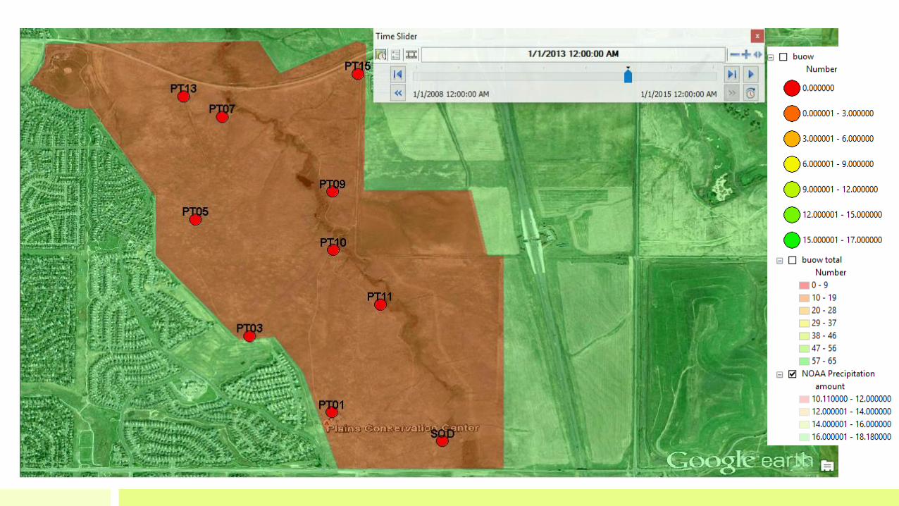
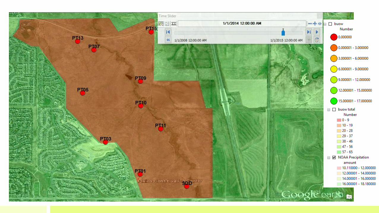
GIS Methods• Field data collector applications were
used to obtain GPS coordinates of observation points
• Temporal and geospatial analyses were conducted to correlate time with bird count totals at the ten observation locations and at area-based totals across the site
• GeoMentors provided student support in project development and GIS software use
• Multiple source databases were used for data analysis correlation to evaluate population trends
• Peer reviews were conducted by GIS, environmental, and ornithology specialists
Step 1
GIS Collector
Apps
Step 2Temporal & Geospatial Analyses
Step 3Geomentor
Support
Step 4Multiple Source
Databases
Step 5Peer Review


Example: Population Trend for Burrowing Owl
Temporal and Geospatial Analysis


Raptor Population Trends• Training ground for young raptors: the lack of human disturbance is a critical factor in the survival of many hawks, eagles, falcons, and owls especially during their first winter
• Raptors are keystone species, an indicator of the health of an ecosystem
• Raptor population trends demonstrate how essential this conserved grassland is to their survival and breeding

• Graph: Total number of raptors observed annually divided by the number of surveys (weighted) conducted
• Heat map: Relative distribution of raptors at each observation point and average for each year represented by the filled polygon color.

Songbird Population Trends
Songbird and raptor populations reveal an inverse correlation in relative numbers at point locations, indicating a predator-prey relationship

• Graph: Total number of songbirds observed
annually divided by the number of surveys
conducted
• Heat map: Relative distribution of songbirds
at each observation point and average for
each year represented by the filled polygon
color


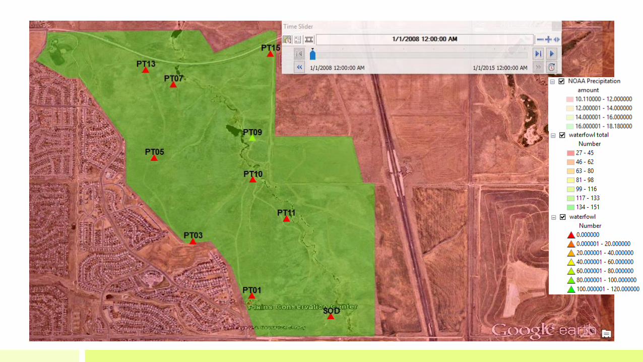
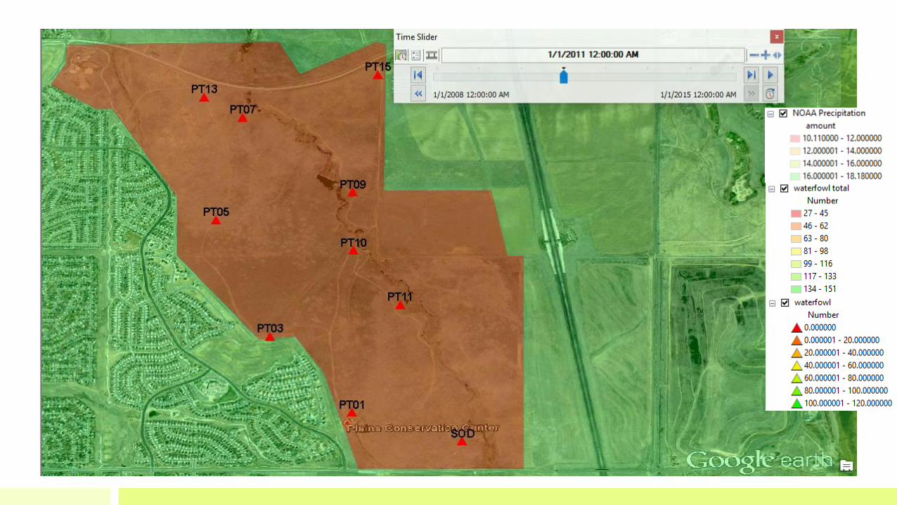
Waterfowl Population Trends•Analyses of waterfowl data indicate an inverse relationship to precipitation
•This may indicate that in years of high precipitation, waterfowl have alternative water sources. Conversely, in years of low precipitation, onsite water sources become essential.

• Graph: Total number of
waterfowl observed
annually divided by the
number of surveys
conducted
• Precipitation: The
average precipitation for
the same year is shown • Precipitation data
obtained from the
closest, maintained
source location from the
site, Denver International
Airport


ConclusionThis study demonstrates an extended educational enrichment opportunity originating in 2013 through the collaboration between Plains Conservation Center specialists and Eaglecrest High School Science National Honor Society students with support from their advisor and GeoMentors.

AcknowledgementsThis Citizen Science Project has been possible through the resources and coordinated efforts of:
• Esri ConnectED and GeoMentor programs
• Data provided by the Plains Conservation Program specialists and volunteers
• Eaglecrest High School Science National Honor Society students
• Eaglecrest High School’s principal and administration

Future Considerations
• Continue trend evaluations of key species including: ferruginous hawk, bald eagles, horned lark, and western meadowlark
• Expand on data analysis correlations
• Continue to recommend management strategies to help support and/or increase species