
2015-RESIDENTIAL APPRAISAL MANUAL - McLennan...
122
Revised 11‐3‐2014 MCAD RESIDENTIAL PROPERTY ASSESSMENT MANUAL
Transcript of 2015-RESIDENTIAL APPRAISAL MANUAL - McLennan...

Revised 11‐3‐2014
MCAD
RESIDENTIAL PROPERTY ASSESSMENT MANUAL

2
Table of Contents I. MASS APPRAISAL OVERVIEW ................................................................................................................ 5
A. DISCOVERY OF REAL PROPERTY AND ITS OWNERS ....................................................................... 5
1. MAPS ......................................................................................................................................... 5
2. DEED RECORDS .......................................................................................................................... 6
3. SUBDIVISION PLATS ................................................................................................................... 6
4. BUILDING PERMITS AND FIRE LOSSES ....................................................................................... 6
5. RENDITIONS ............................................................................................................................... 6
6. FIELD REVIEW ............................................................................................................................ 7
7. AERIAL PHOTOGRAPHY.............................................................................................................. 7
B. LISTING OF REAL PROPERTY AND ITS OWNERS ............................................................................. 7
1. MAPS AND PARCEL NUMBERS .................................................................................................. 7
2. OWNERSHIP LISTS ...................................................................................................................... 8
3. APPRAISAL ROLL ........................................................................................................................ 8
4. APPRAISAL RECORDS ................................................................................................................. 8
5. APPRAISAL NOTICES .................................................................................................................. 9
6. CERTIFIED ROLLS ........................................................................................................................ 9
C. THE VALUATION OF REAL PROPERTY ............................................................................................ 9
1. MEANING OF VALUE .................................................................................................................. 9
2. ELEMENTS OF VALUE ............................................................................................................... 11
3. NEIGHBORHOOD DATA ........................................................................................................... 11
4. THE VALUATION OF LAND ....................................................................................................... 12
5. THE COMPARABLE SALES‐ANALYSIS METHOD ........................................................................ 39
6. THE INCOME‐CAPITALIZATION METHOD ................................................................................ 39
7. THE REPLACEMENT‐COST METHOD ........................................................................................ 41
8. HEARING VALUATION APPEALS ............................................................................................... 42
II. PROCEDURES ................................................................................................................................... 42
A. NEW EMPLOYEES TO RESIDENTIAL PROPERTY ............................................................................ 42
B. INSPECTIONS BY PICTOMETRY .................................................................................................... 43
1. TRAINING ................................................................................................................................. 43
2. ASSIGNED AREAS ..................................................................................................................... 43
3. FULL ACCOUNT REVIEW .......................................................................................................... 43
4. LIMITED ACCOUNT REVIEW ..................................................................................................... 45

3
5. OPENING/ CLOSING PERMITS IN PACS .................................................................................... 46
C. FIELD OPERATIONS PROCEDURES ............................................................................................... 48
1. FIELD MEASUREMENT AND SKETCHING .................................................................................. 48
2. MCAD BUILDING PERMIT WORKSHEETS ................................................................................. 52
3. BPS NEW CONSTRUCTION ....................................................................................................... 53
4. BPS EXISTING CONSTRUCTION ................................................................................................ 57
5. FIELD PERMITS ‐ DISCOVERY AT ITS BEST ............................................................................ 62
D. QUALITY CONTROL ...................................................................................................................... 64
1. APPRAISER QUERIES ................................................................................................................ 64
2. SUPERVISOR QUERIES .............................................................................................................. 64
3. END OF YEAR QUERIES ............................................................................................................ 64
E. RATIO STUDY PROCEDURES ......................................................................................................... 65
F. PROCEDURES FOR PHOTOS ......................................................................................................... 65
1. TAKING PHOTOS ...................................................................................................................... 65
2. DOWNLOADING ....................................................................................................................... 65
3. ENHANCING ............................................................................................................................. 66
4. ATTACHING .............................................................................................................................. 66
G. PROCEDURES FOR GREETING & ASSISTING TAXPAYERS ............................................................. 66
H. PROCEDURES FOR INFORMAL MEETINGS ................................................................................... 67
1. DATA CLERKS ........................................................................................................................... 67
2. APPRAISERS ............................................................................................................................. 67
3. INFORMAL PROCESS PROCEDURES ......................................................................................... 67
4. ONLINE PROTEST PROCEDURE ................................................................................................ 72
I. PROCEDURES FOR PARTICIPATING IN THE APPRAISAL REVIEW BOARD HEARINGS ................... 74
I. CLASSING MANUAL ............................................................................................................................. 74
J. CONSTRUCTION TYPES ................................................................................................................ 74
1. CLASS W ................................................................................................................................... 74
2. CLASS M ................................................................................................................................... 75
3. CLASS C .................................................................................................................................... 75
4. CLASS S ..................................................................................................................................... 75
K. QUALITY OF CONSTRUCTION ....................................................................................................... 75
1. RESIDENTIAL STRUCTURES ...................................................................................................... 75
4
2. PORCHES .................................................................................................................................. 75
3. GARAGES ................................................................................................................................. 76
4. CARPORTS ................................................................................................................................ 76
5. HEATING AND COOLING .......................................................................................................... 76
6. BASIC SPECIFICATIONS AND PHOTOS ...................................................................................... 76
III. ANNEXES ........................................................................................................................................ 115
A. ANNEX 1‐ GUIDE FOR RESIDENTIAL‐‐‐‐PICTOMETRY ................................................................. 115
B. ANNEX 2‐ RESIDENTIAL FEATURES AND CODES ....................................................................... 117
C. ANNEX 3‐ LISTING ORDER OF IMPROVEMENT DETAIL ............................................................. 118
D. ANNEX 4‐ “PORTABLE” CARPORT VALUE GUIDE ...................................................................... 119
E. ANNEX 5‐ RESIDENTIAL AND DUPLEX CLASS CODES ................................................................ 120
F. ANNEX 6‐ MANUFACTURED HOUSING CLASS CODES .............................................................. 121
G. ANNEX 8‐ BARN EFFECTIVE AGE GUIDE‐*Subject to Appraisers Discretion* ............................ 122

5
I. MASS APPRAISAL OVERVIEW
All three branches of government – the legislative, the executive, and the judicial – are involved in the taxation of property. The revenue to be derived from property is a decision of the legislative body; but before the amount of revenue can be determined by fixing tax rates, the executive branch, through the Appraisal District, must establish the property tax base on which taxes are to be computed by determining the valuation of taxable property. The function of the judicial branch is to review, on appeal, the legality of legislative and administrative acts. The administrative process by which the Chief Appraiser accomplishes his task constitutes the appraisal function.
The most difficult phase of property tax administration is the appraisal function, which embraces the original appraisal, review, and equalization. The primary objective of the appraisal function is to provide the basis for spreading the tax levy on property in proportion to the value of each individual’s ownership, thereby establishing the proportion of the tax burden each is to bear. The omission of property or it’s under valuation results in an increase in the amount which the owners of other property not so favored must pay. The Chief Appraiser and the Appraisal Review Board are charged with a responsibility that is vital to the interests of each and every owner of taxable property in the appraisal jurisdiction.
All real property that is subject to taxation can be discovered if there is an adequate CAMA (Computer Assisted Mass Appraisal) system and it is kept current. It is a comparatively simple process to list and adequately describe property if proper descriptors and records are maintained. The valuation of real property, however, is more complicated because it involves the application of a considerable variety of techniques that require specialized knowledge, skill, and judgment; and if hearings are not conducted impartially and equitable decisions rendered, both the individual taxpayer and taxpayers generally suffer.
Appraisal Districts are guided by IAAO (International Association of Assessing Officers) Standards, and USPAP (Uniform Standards of Professional Appraisal Practice). Individual appraisers have to meet all regulations and requirements provided by TDLR (Texas Department of Licensing and Regulation), and comply with guidance and supervision from the Comptroller’s office.
A. DISCOVERY OF REAL PROPERTY AND ITS OWNERS Real property, which consists of land and structures erected thereon, is not difficult to discover
because it is visible, it is sizable, and it cannot be moved without considerable effort. Nevertheless, a surprising amount of it does escape detection and, therefore, goes untaxed. Un‐assessed property can be eliminated by adequate records and proper procedures. The chief sources for the discovery of real property are: (1) maps; (2) deed records; (3) subdivision plats; (4) building permits and fire losses; (5) renditions; (6) field review; and (7) aerial maps and photos.
1. MAPS
The most important record for the discovery of real property is a tax map of the entire appraisal district. Maps are essential for the discovery of all land parcels and they are very valuable in the discovery of improvements. Even personal property appraisers find them useful in their work. Without maps, the inventory of real property is inaccurate and results in the omission of property from the tax rolls. A tax map should be drawn to scale and delineated for lot lines or property lines or both, with dimensions or areas and identifying numbers, letter, or names for all delineated lots or parcels.
To be adequate, the tax map should be segregated into sections and at a scale large enough to serve the purposes of property assessment procedures. A suitable scale for urban property is 100 feet to the inch for subdivided lots and 400 feet to the inch for un‐subdivided tracts. Whatever scale is used, however, should be uniform for all sub‐divided lots and a multiple of that scale should be used for un‐subdivided tracts. This is important because the maps on which un‐subdivided property appears at a smaller scale can be converted into section maps at a larger scale without disturbing map sequence.

6
In addition to the legal description of properties – lot, block, sub‐division, and other designations‐ the maps, blocks, and parcels should be assigned numbers in accordance with parcel identification numbering system and recorded in the data base. The most satisfactory system for indentifying property is based upon a division of the appraisal district into quadrants with section maps numbered in sequence, both horizontally and vertically, from the point where the quadrant lines intersect, preferably in the approximate center of jurisdiction. This systems permits unlimited expansion as the jurisdiction grows without destroying the sequence of map numbers, which is important because it expedites the location of property.
Having a mapping system that is linked with the appraisal CAMA system is critical to the appraisal process. Being able to import desired data from PACS (CAMA software) and overlay it on the aerial with ownership lines speeds up the appraisal process. The appraiser is able to customize desired data to help him formulate an opinion of value.
For tax maps to be useful, they have to be kept current. This requires that whenever property lines are altered because of ownership transfers, deed corrections, or from any other cause, the changes should be reflected on the tax maps as soon as they occur. Information regarding changes is available from instruments filed in the office of the County Clerk, which are readily available to the appraiser on line.
2. DEED RECORDS
The chief source of information for keeping tax maps and other records current through the discovery of property and its owners is the record of recorded deeds in the County Clerk’s office. In addition to deeds incorporating descriptions of individual parcels and ownerships, subdivision plats, after approval by planning commissions, are recorded there. The information to be found in recorded instruments serves other vital purposes of the appraiser also, but their importance as a source for the discovery of property and ownerships is sufficient to make it essential that images of all recorded transactions be obtained and the information processed into appraisal PACS records.
3. SUBDIVISION PLATS
New sub‐division plats are another important source of information for maintaining maps and other records up‐to‐date, which is an aspect of the discovery of property. Copies of approved new sub‐divisions can be obtained from the planning department and scanned or digitized into the appropriate map areas. Newly sub‐divided property necessitates the creation of new records by ownership clerks to keep appraisal records up to date.
4. BUILDING PERMITS AND FIRE LOSSES
Two other valuable sources for the discoveries of property are building permits and fire losses. Building permits reflect new structures that have been built and old ones that have been renovated, enlarged, moved, or demolished. Copies of building permits are available from the building inspection division. Records of fire losses reflect property that has been destroyed, either wholly or in part, by fire. Fire losses, as well as building permits, should be made available to the appraisers’ office as a matter of routine in order that the discovery of additional property and property that no long exists may be expedited.
5. RENDITIONS
Although the law requires owners of real property to render all property owned by them, renditions by owners are not reliable as the only source for the discovery of property. It is true that occasionally a rendition by the owner discloses a discrepancy in the size of a parcel, though rarely, it brings to light omissions. Renditions do provide ownerships in cases where deeds have not been recorded or where the property has passed into different ownership through inheritance. Renditions are a source for the discovery of property and should be used as extensively as possible.

7
6. FIELD REVIEW
One of the results achieved by field reviews is the discovery of property which has not been discovered by any of the other means mentioned. There are, of course, some properties built without securing the required building permit. Sometimes this is a deliberate attempt to evade taxation; but it sometimes is a case of the owner doing his own work and failing, either through ignorance or neglect, to obtain a permit. Checking the maps against the property in the field also occasionally brings to light discrepancies in the amount of land being assessed. The discovery of such property is one of the reasons why field reviews should be made. Surveys made by professional surveyors frequently disclose errors in previous surveys, and if the assessor maintains close relationships with private appraisers, this is another source for the discovery of too much or too little being assessed against owners.
All properties on which building permits have been issued must be visited for the purpose of inspection and appraisal. This annual phase of the work of appraisers takes them throughout the jurisdiction each year. Furthermore, in order to keep valuations current, it is necessary to re‐appraise all properties periodically, by law, not less than every three (3) years.
7. AERIAL PHOTOGRAPHY
These field reviews, along with review of recent aerials afford opportunities to discover any property not already being taxed and insures that none escapes taxation for longer period than the interval that has elapsed since the last scheduled field inspection.
Aerial topography maps and photographs are excellent sources for the discovery of improvements added without permits. Annual photographs will help the appraiser keep current.
Pictometry is the provider for Aerial images for MCAD. It provides recent photographs close to January that are geo‐referenced and allow measurements to be acquired without field inspections. This is most useful for the sake of time and cost of driving, but also prevents taxpayers from hiding improvements by barring access to their property.
ChangeFinder or ConnectAssesment is a software tool offered by Pictometry that provides the added value of drawing perimeter lines around structures and comparing the lines to earlier photographs. This allows the county to eliminate inspecting almost 90% of properties where no noticeable change occurred, and focus on more thorough inspections where required.
B. LISTING OF REAL PROPERTY AND ITS OWNERS
CAMA systems with properly designed software provide for the efficient listing of all pertinent information which is assembled and maintained in the somewhat complicated process of appraising property and are an essential requirement of the appraisal process (IAAO Standard on Ratio Studies‐ 3.2.2.2). MCAD uses a CAMA from True Automation called PACS. Although there are a number of minor records that are utilized in the processing of information, both within the appraisal office itself and between it and other departments of the government, the basic records for listing property and its owners consist of: (1) maps and parcel numbers; (2) ownership lists; (3) appraisal rolls; (4) appraisal records in PACS system; (5) appraisal notices; and (6) certified rolls.
1. MAPS AND PARCEL NUMBERS
The basic records of real property, as previously stated, are maps because they provide accurate descriptions, sizes, shapes, and locations of parcels. An appraisal office needs a good GIS system on which ownership layers, jurisdictions layers and any number of identification layers can be added. The county map should have the outlines of the section maps and their identification numbers delineated on them to be used as

8
key maps for the general location of property. The section maps – in addition to the legal descriptions, dimensions, and other information appearing on the original sub‐division maps – should have delineated on them the parcel identification number. Prints of the section maps should be made available to appraisal personnel for use in the development of land‐value maps for the location and identification of property.
Since property owners do not always change ownership in accordance with plotted lines shown on official plats, many parcels do not follow with platted parcel lines and property descriptions become complicated. Some properties are never subdivided according to an official plat but are transferred on the basis of metes and bounds, which complicates both description and identification of each parcel of property on the maps and on all records used in the assessment of property and the collection of taxes.
When a parcel identification numbering system is first installed, it contains a continuous series of parcel numbers; but property lines change with considerable frequency so that the parcel numbering system should be designed to accommodate future divisions of property.
The parcel numbers should be established by the mapping section; and, as new parcels are created as a result of subdivision, the mapping section should initiate the parcel numbers and relay them to the ownership clerks who will create the new accounts in PACS system. Updating the maps and assigning parcel identification numbers as soon as parcels are created is basic to the successful listing of property.
2. OWNERSHIP LISTS
Ownership lists can be run from PACS system in just about any format needed. The most popular lists are owner alphabetical or by situs address. In addition to the name and mailing address of the owner, this record should include, of course, the parcel identification numbers. This list can be rerun periodically to include ownership changes or these changes can be requested separately.
3. APPRAISAL ROLL
The appraisal roll is the master record of all real property, including exemptions. The roll should provide for the recording the legal description of the property, the parcel number, the name of the owner, owner’s address, the separate assessed valuations of the land and the improvements, exemptions and their amounts along with the assessed value. Once values are noticed to property owners each tax year, this roll is turned over to the appraisal review board. The formal hearing process begins and ends with the certification of values to the entities. The formal hearing process before the appraisal review board is a part of the equalization phase of the property tax process.
The roll can be organized in geographical sequence according to the parcel identification numbers to simplify locating, identifying, checking and field activities. The roll can also be set up in alpha order. The appraisal roll is often used by the entities to check ownership, check values and to answer questions from the public.
4. APPRAISAL RECORDS
The valuation of property is determined by appraisals; and the quality of appraisals depends to a great extent upon the appraisal data that is inputted and stored in PACS system. PACS software is designed to accommodate all pertinent information to be recorded and necessary for computing values in accordance with the property tax code. Appraisal cards can be printed with the parcel number, the legal description of the property, and situs address of the property, owner information, and separate recordings of land and improvements data.
The portion of the appraisal card allocated to the appraisal of land should provide for recording the size in frontage and depth, in square feet, or in acres; the unit value; factor modifications for depth, corner, and other enhancements or detractions, discounts, land use; topography; street; availability of utilities; and the total value.
9
The portion of the form devoted to the appraisal of improvements should be designed so that all construction and finish data, the diagram, and the computations are logically arranged and coincide with each step in the appraisal process. Enumeration of construction details, both interior and exterior, should be itemized so that individual features can be printed and items of construction should be described as to kind and quality of materials and workmanship. The improvement sketches should be included and show outside measurements. Space should be provided for itemizing and computing costs of additional items not included in the basic unit cost factors of the main structure and for additional minor structures. Space should be provided for recording description, date, number, and amount of building permits. The space for computing depreciation should provide for recording the age, the life expectancy, and the percent of depreciation. The computation section should provide space for recording the area; the unit value by floors according to shape and area; the value of additional details; the total replacement value new; the depreciation and other factors; the replacement value of all structures on the parcel; and the neighborhood factor. There should also be space for recording the classification of the improvement and date of the appraisal.
5. APPRAISAL NOTICES
Owners of real property should be notified of changes in the value of their property whether, as required by law, they make a rendition or not, and in accordance with the property tax code. The appraisal notices should include the name and address of the owner, the legal description of the property, the parcel number, the previous value, the appraised value, all exemptions, capped value and everything else required by code and law, including a protest form.
6. CERTIFIED ROLLS
Prior to preparing the tax statements and rolls, certified values are sent to the entities. This roll should include the parcel number, the separate values of land and improvements, exemptions, and the total values. Certified rolls are used by the entities and the assessor‐collector in the assessment phase of the property tax process.
C. THE VALUATION OF REAL PROPERTY
The third procedure in the performance of the appraisal function is the valuation of property. The other two; discovery and listing, comprise the simplest aspects of appraising, but valuation, which involves the establishment of accurate, equalized values by means of sound appraisal techniques, is the most difficult part of appraisal administration. There are three basic methods by which real property can be appraised. They are the sales approach, the income approach and the cost approach. All three can be utilized in the process of estimating the value of land and improvements separately; but all three methods are not applicable to the appraisal of every parcel of property. The method or methods to use depend upon whether the property is improved or unimproved and upon the use for which the property is best suited. Values of individual properties determined by these methods are utilized in the mass appraisal approach to compare with other properties on which value information is available to arrive at the equalized value of all properties.
The determination of real property values for appraisal purposes involves: (1) a clear concept of the meanings of value, (2) a knowledge of the elements that cause property to have value, (3) utilization of the sales‐analysis method of estimating value, (4) utilization of the income‐capitalization method of estimating value, (5) utilization of the replacement‐cost method of estimating value, and (6) hearing valuation appeals.
1. MEANING OF VALUE
Value is a broad term with many meanings and, even when narrowed down so that it applies only to real property, it has many connotations. What the value of property means depends on the purpose for which the value is being estimated. If it is for insurance purposes, value is the cost of replacing property if it is destroyed.

10
If it is for loan purposes, it is the amount the lender is willing to risk, not only on the value of the property as security, but on the reputation of the borrower. If it is for investment purposes, value is the amount of investment on which the future income will produce and adequate return. Other purposes for which value of real property is sought include condemnation, utility rate making, bankruptcy, and of course taxation. Economic theory and legal decisions recognize that different shades of meaning should be given to the term ‘value’ for different purpose, and in an effort to make the meaning more specific, many qualifying adjectives are used. Fair value is the term that is used to designate the base for utility rates and for setting prices in condemnation proceedings. Fair market value is used by brokers to mean the real estate market. Normal value is employed in an attempt to compensate for unusual economic conditions. Forced sale value refers to bankruptcy proceedings and sheriff’s sales. Value as a going concern purports to include the intangible as well as the tangible assets of an operating business. From the many terms that have been developed for describing value as it pertains to real property and the confusion created thereby, there has emerged a term that has been sanctioned by the courts as the accepted concept of value for assessment purposes and on which taxes are to be computed. This term is ‘market value’; and when it is carefully defined and its meaning clearly understood, the appraiser is provided with a concept that at least is definite if not susceptible of easy translation into a precise answer.
Market Value is defined by the Property Tax Code as the price at which a property would transfer for cash or its equivalent under prevailing market conditions if:
a) Exposed for sale in the open market with a reasonable time for the seller to find a purchaser; b) both the seller and the purchaser know of all the uses and purposes to which the property is adapted and for which it is capable of being used and of the enforceable restrictions on its use; and c) both the seller and the purchaser seek to maximize their gains and neither is in a position to advantage of the exigencies of the other.
The appraisal of property is not an exact science and, therefore, there is no such thing as the value of a property. Value is an opinion. It is the opinion of the appraiser making the value determination. Appraisers must ascertain the discrepancies between the definition of market value and the facts of each transaction allowing them to arrive at an estimate of value.
Appraisers are required to determine the value of all property that is subject to taxation, although sales, income, and cost information to support the definition of market value is available for only a very small percentage of the properties which they are required to appraise. The immense complications of determining market value of all properties have forced appraisers to resort to standard methods and procedures that result in acceptable approximations of market value which have been recognized by the courts as valid. By the use of standard procedures in the determination of values, comparisons can be made with properties for which market values have been determined on the basis of available sales data and the market value of properties on which there is no valid sales data to determine a proper appraised value.
The adoption of standard methods and procedures not only provides the appraiser with a practical approach to the appraisal of the vast amount of property that is required of him, but it has the important advantage of promoting the equalization of values between properties. Equalization of values is not a concern of private appraisers; but it is a requirement of the Property Tax Code and the Constitution. Equalization can be attained only by the use of standard methods and procedures based upon such evidences of market value as are available and applied with the exercise of sound judgment. The law requires that appraisal districts follow the most recent edition of (Uniform Standards of Professional Appraisal Practice) USPAP standards 6 & 7 which apply specifically to mass appraisal techniques when appraising property.

11
2. ELEMENTS OF VALUE
Real property has value because it is capable of providing amenities and satisfactions of living, services in the production of goods, and income in the form of rents or leases. There are many elements that contribute to the value of property, some of them stemming from the nature of people and some of them to be found in the characteristics of the property itself.
Desire, demand, and supply are elements with broad human implications in affecting the value of property. Human beings have a need or craving to satisfy human wants; and this urge to acquire property affects its value. Furthermore, this desire is being renewed constantly because of changes in styles, customs, and new inventions. The demand for property makes it valuable. As demand increases, prices rise, and as demand falls off, prices decrease. The supply of property in proportion to demand is reflected in value by its increase in proportion to the scarcity of property that is available.
Two fundamental characteristics of real property that have a marked effect on value are fixity of location and durability. Land cannot be moved so that its utilization is limited in scope and it inevitably is an integral part of the environment in which it is located. Real property, even including improvements erected on the land, is of comparatively long duration. This has a stabilizing effect so that value cycles are long enough to permit investments of comparatively long periods so that fluctuations in prices are less than in most commodities.
There are physical, economic, legal and social factors that influence the value of real property. Physical factors include extent of area under analysis, land use, general appearance, and relation to the jurisdiction as a whole, availability of shopping and marketing facilities, street planning and transportation, availability of utilities, topographic and scenic features, undesirable influences and the stage of development of the area. Economic factors include the purchasing power of the residents, sales and rental levels, and rating for loan purposes. Legal factors include local taxation policies, public restrictions, and private restrictions. Social factors include homogeneity, availability of cultural and recreational facilities, and the income level of the residents.
3. NEIGHBORHOOD DATA
A neighborhood may be defined as an area of complementary land uses in which all properties are similarly influenced by the four forces affecting property value: environmental (physical), governmental, social, and economic forces. The area of the neighborhood will contain complementary land uses. For example, in a residential neighborhood there will be properties that provide services to the neighborhood such as schools, churches, parks, and commercial facilities. Neighborhood is primarily an urban and suburban concept; however, it can be extended for appraisal purposes to rural areas to help with stratification (IAAO‐Standard on Mass Appraisal‐3.3).
The boundaries of a neighborhood must be delineated for the purpose of analysis. Identification of the boundaries begins by considering the subject's surroundings and then moving outward from the subject. Influences that could affect the subject's value because of its location need to be identified. Once the assessor has extended the geographical search to the point that there are no longer any factors influencing the subject and surrounding properties, a boundary or a neighborhood can be drawn.
The three types of boundaries are natural, political, and manmade. Natural boundaries include rivers, lakes, hills, ravines, and undeveloped land areas. Political boundaries are usually those established for governmental purposes, such as city limits, school districts, zoning districts, and assessment districts. Political boundaries expose similar properties to different conditions depending on the location regarding those boundaries. Man‐made boundaries are streets, highways, freeways, railroad tracks, and major utility rights‐of‐way that tend to form a psychological border or a physical boundary.
Because of change, a neighborhood typically has a life cycle. It may be in a stage of growth, which is a time of construction and development. It may be in a stage of stability, in which case supply and demand are about equal. It may be in a stage of decline, which reflects a diminishing demand or desirability. It may be in a

12
stage of revitalization, in which a declining neighborhood has become economically desirable again and is experiencing renewal, reorganization, rebuilding, or restoration. There is no set life expectancy for a neighborhood. Many neighborhoods remain stable for a long time. Also, decline may occur at a rate that is barely perceptible and can be interrupted by an increase in demand or a change in use. The assessor must determine what stage a particular neighborhood is in and identify any changes that will affect future uses and value.
There are four forces, or sets of factors, to be considered in neighborhood analysis: environmental (physical), economic, governmental, and social. There are a number of factors in each of the four categories and many of these factors frequently change. The appraiser's office should maintain a database on the factors affecting value within the jurisdiction and the various neighborhoods located in the jurisdiction.
The four forces affecting value will be considered within the framework of four property classifications: residential, commercial, industrial, and rural. Before extensive analysis can be done, the appraiser usually classifies the property being appraised. The principle of highest and best use is important in this step, because its application is necessary for correctly classifying the property being appraised.
4. THE VALUATION OF LAND
a) INTRODUCTION
All three methods of appraising real property‐sales analysis, income capitalization, and replacement cost‐are utilized in the appraisal of land, exclusive of improvements, for assessment purposes. No absolute rules can be formulated for selecting the method that is preferable to use for estimating the value of the various types of urban land; but the character of the property usually indicates the method that lends itself best to use in making the value estimate.
Unimproved urban land parcels can be appraised best by the sales analysis method because, except for such usage as parking lots or outside storage, vacant urban land produces no income; and, since there are no improvements, the replacement‐cost method is not applicable. Both the sales analysis method and the income‐capitalization method are useful in the appraisal of land with improvements by appraising the property as a whole and then determining, by the replacement‐cost method, the value to be attributed to the improvements which, when subtracted from the value of the whole property, leaves a residual amount that is attributable to the land as its value. Sales analysis is about the only method which has a practical application in the appraisal of residential‐type property that is not customarily rented. Commercial property that is infrequently sold but frequently rented or leased lends itself to income capitalization as a method of estimating its value. In many cases, assessors are limited in the choice of a method by the information, or the lack of it, that is available to them.
Estimating the value of individual urban land parcels from sales, income, and replacement cost by mass appraisal, the approach that is used for assessment purposes, is accomplished by a comparative process that is a derivative of the three basic methods by which mass appraisal is implemented. Mass appraisal by comparison consists of the application of general rules and standardized procedures to the recognized basic methods of appraisal and constitutes the urban land appraisal system. The procedures involved in mass appraisal of urban land involves the development of land value information that is utilized to estimate the value of parcels for which such information is available and comparison of similar properties with them to establish the value of all parcels in the assessment jurisdiction. The procedures for implementing the system provide for continuing reappraisal activities. As the term "mass appraisal" implies the work is organized functionally so that appraisers devote themselves to the technical aspects of appraisal and such details as posting value information to records and computation of parcel values iii delegated to the clerical staff.
b) THE URBAN LAND APPRAISAL SYSTEM

13
A system of property appraisal for assessment purposes must be relatively inexpensive to be practical and the resulting values must reflect equality and uniformity to comply with the law. To meet these three basic requirements, a system employing mass appraisal techniques in the application of the three basic methods of determining value by analysis and comparison has been developed. The mass appraisal approach to the determination of land values makes it possible to appraise whole groups of urban land parcels in no more time than it takes to appraise one parcel by the individual appraisal approach employed by private appraisers; and, although a more precise value no doubt is sacrificed by mass appraisals, the results are sufficiently accurate to serve as a basis for taxation and economy of operation is achieved thereby. The method also provides equalization and uniformity through the process of comparison, which requires that like properties be compared with each other and the differences between unlike properties determined.
The system of determining the value of urban land for assessment purposes by the mass appraisal approach incorporates: a classification of land parcels; an analysis of value influences; the establishment of unit values; and the application of modifications for variations.
(1) Classification Urban land has value because of the uses to which it can be put. There are many elements that
contribute to the creation of value; but the degree to which the different elements influence value varies with the character of the property. In order to reflect the effect of value influences on all types of property an urban land classification system that segregates properties into groups having common value characteristics is used for convenience in estimating value.
All urban land, regardless of its characteristics, is classified according to use. This does not mean that classes are designated in accordance with the uses to which the property is being put currently, although this will be proper in the vast majority of cases. Actually, class designations are made to coincide with the highest and best use to which the property can be put. Since use is the only basis for the classification of urban land, the classification system provides five basic classes as follows:
(a) ResidentialClass,whichincludesproperty,whetherowneroccupiedorleased,theproperuseofwhichprovidesaresidenceeitheronamoreorlesspermanentorpurelytemporarybasis;(b) CommercialClass,whichincludespropertyusedforretailcommercialenterprises;(c) IndustrialClass,whichincludespropertyusedforlightandheavyindustryandcoversmostwarehousedistricts;(d) InstitutionalClass,whichincludespropertyusedbygovernmentsofalllevels,forpublicandprivateschools,forreligiouspurposessuchaschurches,andforhospitalsandsanatoriums;and(e) RecreationalClass,whichincludespropertyusedforparksandplaygrounds,whetherpubliclyorprivatelyowned.
Classification of urban land for assessment purposes does not require the refinements that are stipulated in the zoning ordinance. It is sufficient to recognize only the broad distinctions included in the foregoing classification system. Most property classified as Institutional and Recreational qualifies for exemption from the property tax; but there are properties in both classes that are privately owned and operated and are subject to taxation. Whether taxable or not, however, all property should be classified.
(2) Value Influences Successful application of the comparison process upon which the mass appraisal of property is based
requires knowledge of the numerous influences that affect the value of urban land and how to measure their impact upon the value of urban land parcels. The forces that influence the value of property both create and

14
modify value and include physical, economic, legal, social, and intangible factors. They may be either an inherent part of the property or they may be extraneous to it.
Some value influences have an impact over a wide area‐such as an entire assessment district embracing a city, a metropolitan center, a school district, or a county‐and are useful when determining the general level of values within the jurisdiction. Others influence the values throughout a neighborhood or area within an assessment district and are evaluated in connection with establishing unit values applicable to groups of parcels limited to a block or even a part of a block or extending up to an entire neighborhood or district. Yet other value influences relate only to individual parcels and are utilized in the derivation of individual land parcel values by reflecting the many variations that exist between them.
Influences that apply to jurisdiction‐wide areas determine the total range of values and they indicate the ratio of value between the land‐use type classes. These forces derive from the demand and supply of land in the jurisdiction and consist of the level of prosperity in the community, the density of population, the pattern of wealth, and government policy. Most of these value influences are economic but they may be caused by legal regulations.
It is the forces which exert influence upon the value of parcels within a neighborhood or area that differentiate the values between classes of property and between properties of the same use class in different locations. These influences are local in effect and usually in origin. Some of them are economic while others are physical and social. All classes of property are affected by the influence exerted by some of them upon value. The parcel group or neighborhood value factors consist of general appearance and re‐lotion to other areas, accessibility, street planning and transportation facilities, amount and character of traffic, availability of utilities, stage of development, neighborhood characteristics, topographic and aesthetic features, sales and rental levels, rating for loan purposes, and public and private restrictions.
The third group of value factors with which appraisers are concerned are those which influence individual parcels and serve to differentiate between them. These factors differ from other value influences in that they can be measured mathematically and, therefore, reduced to factors. They are the ones that are utilized in the process of computing parcel values because their effect upon specific properties can be determined by the analysis of value data. The factors that influence the value of individual parcels are all physical and consist of size, shape, location, plottage, and topography.
(3) Units of Value There are three units that are used to measure value in the appraisal of urban land parcels. They are the
acre, the square foot, and the front foot. Acre and square foot units are measurements of area only. The front foot unit is a measurement of both area and shape.
The choice of the unit to use as the basis for measuring value in the appraisal of land is governed chiefly by the highest and best use for which the property is suitable. If it is size that is the predominant factor which influences the value of a parcel, the appropriate unit is an acre if the land is comparatively cheap or a square foot if the land is expensive. If the value of the property is influenced by both size and shape, the front foot unit is the proper one to use. It is possible to use square foot units to reflect the influences of both size and shape by a proper modification technique, but the procedure is more cumbersome than it is for modifying front foot units and serves no useful purpose where the common basis for transactions is the frontage.
The value of industrial property usually is not enhanced by street frontage beyond adequate entrance to, and exit from, the property. The shape of an industrial site, unless it is so abnormal that its utility is damaged, is of little importance in creating value. It is size that is of greatest importance; and since industrial property customarily is of comparatively high value, it is frequently desirable; especially in the case of small industrial

15
tracts, to use the square foot unit, whereas‐for large tracts acre units simplify computations by avoiding large numbers.
There are instances in which a combination of area and linear units should be used. Two examples are: (1) an industrial property with considerable frontage that is valuable as such because it is used as offices or for display; and (2) an un‐subdivided tract with street frontage that affords enhancement of value for subdivision purposes because of the availability of public improvements and public utilities. In cases such as these, front foot units should be used for a reasonable depth‐probably in conformity with the typical depth of lots in the area‐and square foot' or acre units used for the remainder.
Factors affecting urban land values that relate to areas‐it was pointed out in the previous section‐have the most constant effect so that, for a given character of property, the larger the area, the greater the value; but it is likewise true that, for most urban land, the shape of a parcel has a bearing upon its value. The influence of shape on value is reflected most by frontage on the theory that, other features being equal, the greater the frontage, the greater the value. This is especially true of commercial property, and it is generally an important factor in the value of residential property. As a consequence, it is desirable that the front foot unit, which is a measurement of both size and shape, be applied in the appraisal of commercial and residential property.
Since only one factor that influences units of value is involved in properties whose values are affected by variations in size alone, the unit itself becomes a standard and it needs no modification to make unit‐value comparisons of one property with another. To reflect the influence that both size and shape, in all the variations that occur, exert on the unit value, however, necessitates that a standard be established to measure the variations when making comparisons of parcels in the appraisal process. A "standard unit foot" or a "standard front foot unit," terms which are synonymous with "unit foot," are defined as: "A rectangular portion of urban land with a frontage of one foot and a depth equal to that of a standard lot." (See Assessment Terminology, International Association of Assessing Officers, page 34.) The standard lots that have been adopted for the City of Fort Worth are a parcel of land that may be variable in width but have an inside location , level terrain , and a depth of 100 feet for commercial parcels and a depth of 125 feet for residential parcels.
The value per front foot of all parcels of standard depths is equal to the value of each front foot unit. Other elements affecting value‐such as shape, variations in depth, plottage, and locations on corners and alleys are applied in the form of modifications of the front foot unit value or a combination of a modification of the front foot unit value and a separate application of influence for corner location of commercial property.
(4) Modifications A standard parcel, as the definition prescribes, eliminates all value influences except that of the front
street, and, therefore, needs no modification. Modifications of nonstandard parcel values, however, have to be made for the many variations that there are from the standard parcel. Variations in depth, shape, and location with respect to public ways, are applied to the unit of value by means of formula which employ depth, triangle, corner, and alley value influence factors that have been developed and incorporated in schedules. The modifications that are applied to the property as a whole, usually in the form of percentages, are for the value influences of plottage, topography, view and nuisances.
(a) DepthModificationVariations in the depths of parcels of urban land affect their value. The variation in value, however, is
not in the same proportion as the variation in depth. This influence of depth is based upon the theory that the portion of a parcel located close to a street is more valuable than an equal portion located further from the street. For example, a series of strips of land parallel with a street and identical except that they ,recede successively from the street have less value as the distance from the street increases, This is to say that a parcel

16
with a depth of 50 feet is worth more than half as much as a similar one that is 100 feet deep; and a parcel 200 feet deep is worth less than twice as much as one that is 100 feet deep, a number of rules have been developed for the application of depth influence, Chief among them are: the Hoffman Rule which holds that the 50 feet of depth nearest the street of a 100‐foot lot is worth two‐thirds of the value of the parcel whereas the remaining 50 feet is worth only one‐third; the 4‐3‐2‐1 Rule in which the first 25 feet of depth of a 100‐foot lot is worth 40% of the entire value of the lot, the next 25 feet 30%, the next 25 feet 20%, and the 25 feet farthest removed from the street 10% of the value; and the Somers Rule which established a table of factors for each foot of depth and was based upon a study of depth influence on the relative market value of land parcels in St. Paul, Minnesota., Following the example of Somers, many depth tables have been developed by plotting cumulative curves of values, the steepness of which depends upon the enhancement it is desirable to bestow upon the value of the parcel as its depth recedes from the street,
The Somers depth factor table, sometimes with adaptations, has been used by more assessors than any other for a long time, Three tables ‐ one for residential and two for commercial ‐ have been developed and incorporated in this manual , One of the commercial depth factor tables is used to modify subdivided commercial parcels , The other table was developed to use in modifying front foot units of shopping center‐type commercial properties, By using front foot units instead of square foot units, which this latter table makes possible , the relationship of values between tracts and parcels of comparatively shallow depth can be reflected.
(b) ShapeModificationIrregularly shaped parcels vary from the standard lot and the effect which these variations in shape have
upon property needs to be measured. Establishing mean average widths and depths and appraising as a rectangular parcel suffices to account for the effect of shape on the value of residential parcels. To provide shape adjustment for commercial property, however, it is necessary to reduce the parcel to rectangles and triangles; and to facilitate the computation of the triangle portions, a table of factors to apply to triangular shapes is needed in addition to the depth factor table which suffices for rectangular‐shaped parcels , Curved boundary lines , which are so prevalent in modern‐day planning, can be reduced to straight lines which enclose an area that is near enough to the actual area, so that, when computed, the difference in value is insignificant,
There are two kinds of triangular parcels that are pertinent to the application of modifications. One is a delta triangle which has its base on the street; and the other is a nabla triangle which has its apex on the street. Since all triangles contain half as much area as a rectangle with the same width and altitude, on the theory that the portion of a parcel nearest the street is more valuable than an identical portion farther from the street, no delta triangle can have a value of less than one‐half of a rectangle of equal width and depth. Conversely, a nabla triangle can never have a value of more than one ‐half of a rectangle of which the other half is a delta triangle. As the depth of a delta triangle increases, the portion within a given distance from the street increases; but as the depth of a nabla triangle increases the portion within a given distance from the street decreases. A deep delta triangle, therefore, has a higher proportion of the value of a corresponding rectangle than has a shallow one.
The triangular factor table which has been adopted in this manual is the one developed by John Zangerle. The depths in the table are for perpendicular distances from the base to the apex of a triangular parcel for both delta and nabla triangle shapes.
(c) CornerModificationThe location of a commercial parcel at the intersection of two streets enhances its value over that of a
comparable inside lot because of the advantages that go with frontage on a street. These include access to light and air, to public ways for purposes of moving goods in and out of buildings and of ingress and egress of persons working or living in the building, to the flow of pedestrian and vehicular traffic, and the availability of suitable

17
space for show‐windows and other advertising purposes. The benefits that a corner location bestows upon residential‐type property, however, are not so certain on the theory that the disadvantages of noise, traffic hazards, and loss of privacy offset the advantages.
The extent to which corner locations influence the value of land parcels varies with the land use. The difference in value between a corner parcel and an inside parcel is far more pronounced in land devoted to commercial retail use, for example, than in land used for residential purposes. And since land devoted to commercial retail usage tends to be the most valuable land in an assessment jurisdiction, the greatest enhancements due to corner locations are found in the downtown section.
The distance from the intersection of two streets to which the value added by corner influence extends constitutes the zone of corner influence. Much of the advantage of corner location for retail commercial property derives from the increased foot traffic that is characteristic of such sites. Traffic counts reveal that it extends for a considerable distance from the intersection along both streets and it is reasonable to assume that the influence upon value is not necessarily limited to the corner parcel. Some as‐assessors have adopted zones of corner influence that disregard property boundaries and extend beyond corner parcels, the most common being 100 feet along both streets from the corner. Others have limited the zone of corner influence to the corner parcel or to 50 feet along the front street from the intersection and 100 feet along the side street, whichever is less. To compensate for the greater value one inside parcel has over another because its location is closer to a corner, the front foot units are graduated downward as the distance from the corner increases. This influence is applied only where it is recognized as being applicable.
For properties other than retail commercial, the zone of corner influence should be limited to the parcel located on the corner and, even then to a limited distance from the intersection. The zone of corner influence for all noncommercial property in this manual is limited to the corner parcel for a depth not to exceed 100 feet along the side street from the corner or to a frontage not to exceed 50 feet of the corner parcel and a depth of 100 feet. The reasons for limiting corner enhancement of residential property to the corner parcel is that an adjacent parcel gains nothing from proximity to a side street in access to light, air , and side entrance, which are the chief advantages residential property derives from corner location. Indus‐trial property gains its greatest enhancement from corner location because of the increased accessibility for loading and unloading purposes, which benefits do not extend to the adjacent inside parcels.
The apportionment of value within the zone of corner influence has been done by various methods. Some are based on percentages; others are based on the side street unit modified by the depth factor for the width of the parcel; and yet others have used ratios of the front street and side street units computed as if the parcel faced the high‐valued street. Most assessors, however, have found that percentages do not accurately reflect the proper relationship of corner enhancement between properties with varying shapes and values; and that computations based on side street units or combinations of side street and front‐street units produce too great a value attributable to corner enhancement. As a consequence, modifications have been introduced whereby averages of front street and side street units are used and the result modified by a table of factors based on the width of the parcel and computed with the side street as frontage but not to exceed 100 feet.
(d) AlleyModificationAlleys enhance the value of property because they afford the same advantages as streets, although to a
much less degree. The effect upon residential property from alleys is small; but the enhancement in value which alleys add to commercial property is material. The effect that rear alleys and side alleys exert upon property values is different in degree and in application. Sound assessing procedure, therefore, requires that side alleys receive different treatment from that given to rear alleys.
18
Rear alley influence may be treated in several ways. The simplest and most common procedure is to add a given amount of depth to the parcels, such as adding half the width of the alley, thus relating the amount of alley influence to alley width. The addition of half the width of the alley to the depth of the parcel has been adopted for residential parcels only and its application results in a decreasing of the value enhancement with the increasing depth of the lot. This is logical because a rear alley adds more value to a shallow residential lot than to a deep residential lot. Furthermore, it is generally conceded that beyond 100 feet of depth in residential parcels rear alley influence has a value that is equivalent to ownership of one‐half of the alley. Another method must be used to reflect the enhancement of rear alleys to commercial parcels because the influence does not vary with the depth and rear alley influence adds greater value to a parcel than does ownership of on~‐half of the alley.
An analysis of the influence of rear alleys on the value of commercial parcels based on sales, leases, and informed opinion indicates that the enhancement amounts to approximately 1% for each five feet of alley width. In developing the rear alley factor table, therefore, a factor of .004 was assigned for each two feet of alley width.
The approach to a determination of the influence of side alleys on the value of property is basically the same as that for commercial rear alleys and depends upon the same variables: the width of the alley and the front foot unit of the street on which the parcel fronts. The table used is similar to the rear alley influence factor table, and the factors derived from it are applied in the same manner. The theory underlying the rule is that, since side alleys confer upon property some of the characteristics of a side street, it is reasonable to expect side alley influence to be distributed in the same way as corner influence. The theory of this distribution, it will be recalled, is that the corner influence is apportioned so that the portions of a lot equidistant from the side street are enhanced in value by the same amount, regardless of their distance from the front street. Applying this theory to side alleys, it is apparent that it is not desirable to permit influence to reduce side alley enhancement as the distance from the street increases. The basis upon which the side alley influence factor table is constructed is that a side alley enhances the value of a parcel approximately 1 1/4% for each five feet of alley width, and, therefore, a factor of .005 was assigned for each two feet of alley width.
(e) PlottageModificationThere is one factor which stems from size, shape, and location that affects the value of a parcel but its
influence cannot be measured by the application of depth, corner, alley, and triangular factors. This value factor is plottage, which is defined in Assessment Terminology as "those factors of size, shape, and location with reference to other plots which add or detract from the value of a plot for a given purpose." Modification for plottage is applied as a percentage enhancement or discount to the value of the parcel as a whole. Plottage influence occurs rather infrequently and usually because the property is inadequate in size and shape to afford off‐street parking where it is a requirement for the highest and best use of the property. Other instances of plottage value in which parking facilities may not be a criterion are the need for larger parcels to accommodate commercial enterprises, multi‐family dwellings, and institutional type structures, for which there is a demand, that require a greater area than the subdivided lots and their separate ownerships afford.
(f) TopographicModificationThe standard lot, in addition to other specifications, is a level parcel. Variations in topography, to the
extent they affect the value of a parcel, have to be determined and applied as a discount to the value of the parcel as a whole. For commercial usage, the problem is comparatively simple because level topography is most desirable and the expense of correcting the deficiency can be estimated quite accurately on the basis of excavation costs if the parcel is above grade, the cost of filling if the parcel is below grade, the cost of providing drainage if that is a problem, or whatever may be required to cure the situation. The amount of the modification is equivalent to the cost of correction. The problem of modifying the topographical variations for residential property is more complicated and rests on judgment rather than mathematical computation. There was a time

19
when the most desirable residential parcel was level; but currently, especially in the more expensively improved developments, the picturesque quality of uneven topography has an attraction that offsets the additional cost of development or in some cases adds to the market value of the parcel. Under such circumstances, the value of land parcels tends to depend more upon whether they afford a building site rather than size being the chief value factor. Whether to modify residential parcels for topography at all or how much must be left to the judgment of the appraisers who will be guided by the evidence of market data.
(g) ViewModificationIt is only residential‐type properties that are modified for view, because this factor, if it exists, adds
nothing to the value of commercial properties. Application of the modification, which is recorded as a percentage enhancement to the property value, is utilized only where individual parcels are favored with a view which the neighboring parcels do not have. If a view is a common feature of the parcels in an area, as sometimes happens, the effect of this value factor is incorporated in the value units.
(h) NuisanceModificationThere are nuisances that stem from various causes which affect adversely the value of some land parcels
but do not influence the value of others. Many of these are caused by nonconforming use and spot zoning. The chief nuisance factors include public institutions‐such as churches, schools, and playgrounds‐where throngs gather, particularly at night, and create noise and traffic problems; fire stations in residential areas; misplaced cemeteries; railroads through residential areas; and offensive odors. An analysis of each case has to be made by appraisers and the extent of the modification that should be allowed determined and applied as a percentage deduction in the value of the property.
c) DEVE LOPMENT OF VALUE INFORMATION
The appraisal system employed to determine the value of urban land parcels for assessment purposes utilizing mass appraisal techniques has been described in the preceding chapter. The remainder of this portion of the manual dealing with the appraisal of urban land is devoted to the procedures by which urban land parcels are appraised within the framework of the appraisal system and the methods that are used to maintain values at an equitable and uniform level and at market value. The procedures for obtaining, examining, and processing the land‐value information that provides the evidences of value which the appraisers utilize in estimating value is the subject of this chapter and consists of: (1) accumulating and analyzing value influences; (2) developing modification factor tables; (3) accumulating and analyzing value data; and (4) recording information on land‐tables.
(1) Accumulating and Analyzing Value Influences There are many forces that influence the value of urban land parcels. Knowledge of these value
influences and how they affect value comprises an essential part of the appraisal process. Urban development is reflected in land use that forms a pattern of areas or neighborhoods within which the properties are homogeneous and, therefore, susceptible of comparison in evaluating the various forces of value influence. An area for analysis must be limited to similar properties and, generally speaking, the area terminates where there is a definite change in the quality of the property observable in the character of development. The many forces that influence the value of urban land may be grouped into the four categories of physical, economic, legal, social, and intangible.
(a) PhysicalValueInfluencesThe value influences that are characterized by physical attributes include general appearance and
relationship to other areas; accessibility to persons, places and things; street planning and transportation facilities; availability of utilities, amount and character of traffic; size, shape, location; plottage; and topography.

20
(i) GeneralAppearanceandRelationshiptoOtherAreasDesire to own property is influenced to a great extent by the overall appearance of an area. The
impression made by any area due to the condition of the streets, sidewalks, vacant lots, lawns, landscaping, and the condition and design of buildings are factors that appraisers must take into‐consideration when appraising urban land parcels. Furthermore, the appearance of the area as a whole in its relation to other areas and to the entire jurisdiction of which it is a part as to its location with reference to the downtown section, its comparative desirability, and its trend o(:development are factors that are. important attributes of the comparative process of appraisal.
(ii) AccessibilitytoPersonsIPlacesandThingsThe desirability of property in an area depends largely upon its accessibility to those persons, places, or
things which contribute most to the purposes for which property is used. Residential property is more valuable if it is located close to employment opportunities, shopping facilities, and recreational, educational, and cultural advantages. The effect of schools, libraries, churches, parks, and playgrounds upon the value of property in residential areas depends largely upon their proximity. The presence of cultural facilities in a community contribute to the enhancement of properties generally; but when such facilities are close enough to cause disturbance and create parking inconvenience to residents, there is an adverse influence upon the value of property thus affected. Commercial property values vary directly in proportion to the access they command to suitable consumer markets. The value of industrial property increases as it becomes more accessible to markets and to sources of raw materials, power, and labor.
(iii) StreetPlanningandTransportationFacilitiesClosely allied to accessibility are street planning and transportation facilities. Physical proximity is not as
much a criterion of accessibility as methods of getting into and out of an area. Street and highway planning, which provides maximum protection but also permits easy access to the major traffic arteries, add to the desirability of the area and, therefore, are value factors which apply to all types of development. In poorer areas where the residents do not provide their own transportation, public transportation facilities are of great importance as a factor that affects value. Expensive residential areas, however, are not greatly influenced by public transportation facilities; and high values extend out into suburban areas if rapid access to downtown is available by private transportation over well‐planned traffic arteries. Inadequate street planning and public transportation facilities have the reverse effect on property. If transportation facilities are substandard, downtown commercial property will depreciate in value. Industrial property is dependent upon the movement of materials and finished goods so that values tend to parallel the extent to which freight transportation facilities, including carriers and the thoroughfares on which to operate, are available.
(iv) AvailabilityofUtilitiesThe availability of the major utilities (water, electricity, gas, sewage, telephone, and railroads)
determines to a considerable extent the value of property in an area. All of these value factors, except railroads, add to the value of property generally, but the presence of railroads, aside from the benefits it contributes jurisdiction wide, favorably influences the value of industrial‐type property whereas it detracts from the value of residential property.
(v) AmountandCharacterofTrafficAlso closely related to accessibility is traffic, both as to amount and character. Highest commercial
values are to be found where there is the greatest pedestrian traffic; and commercial areas with heavy vehicular traffic have a comparatively high value, although if the vehicular traffic is fast it can have an adverse effect on value. Adequacy of off‐street parking is an important factor upon the value of retail commercial property. Industrial property needs to be accessible to arterial highways and in an area that is not highly concentrated with pedestrians who impede the movement of raw materials and finished goods that are such a vital part of

21
manufacturing and other industrial activities. Less traffic and the accompanying minimizing of noise and hazards contribute to the enhancement of residential property.
(vi) SizeOf all the factors affecting the value of individual urban land parcels, those relating to size have the most
constant effect. These value influences are reflected in the area of properties and in the amount of street frontage they occupy in proportion to the area of the parcel. Other things being equal, the larger the size, the greater the value; but there ‐are variations in the sizes of urban land parcels, not only as to area but also as to street frontage, and these have to be considered when appraising property. The greatest impact of frontage on the value of urban property is upon commercial property with considerable less influence on residential‐type property, and practically none at all upon industrial‐type property.
(vii) ShapeAnother factor in the value of individual urban land parcels is shape. If the shape is so irregular that it
minimizes the highest and best use of the property, this influence of shape must be considered. Another factor to consider is that different shapes result in a difference in the ratio of street frontage to area. If the shape of a parcel prevents complete utilization of the property for the purpose for which it is best suited, its value is depreciated to the degree this is so. This adverse influence is greatest in the case of commercial property where values are high and space utilization at a premium. Irregular shape is not always a depreciating factor. Many residential areas are designed in non rectangular shapes for their aesthetic appeal, thereby enhancing their attractiveness and ‐hence their value.
(viii) LocationOne of the most important value determinants of a parcel of urban land is its location with reference to
public ways. This stems from the necessity of possessing street frontage which is essential to provide ingress and egress to and from the property. The value of this factor varies from one property to the other depending largely upon the usage of the property. In the case of industrial property, adequacy is limited in most cases to mere access. For commercial property, it becomes much more important because, in addition to ready accessibility to customers, there is value in street frontage, including corner locations, for purposes of being available to a greater flow of traffic and for use as show and advertising space. Residential properties benefit from light, air, parking space, view, and opportunities of developing and landscaping; and locations that provide these in greatest quantities are the most valuable parcels in the area. Corners and alleys confer these enhancements upon residential properties but they may also confer disadvantages in the form of more noise, less privacy, and higher paving costs in the case of corners and unsightliness due to failure to keep alleys free from debris.
(ix) PlottageAdequacy or inadequacy of size in accordance with the highest and best use of a parcel, sometimes
referred to as size plottage, is a value influence of importance in some areas and for certain types of property. It is present in the case of desirable locations for shopping centers, individual or group office developments requiring off‐street parking, multi‐family building sites, association headquarters, and for institutional and recreational developments. With the tendency toward larger and fewer commercial enterprises, demand for larger sites sometimes has a bearing upon values in the highest‐valued retail commercial districts. The influence of plottage, while fairly obvious in some instances, is difficult to re‐cognize in others. Actually, it usually does not become an influence upon value until there is a demand for a specific usage of the property and the adequacy ∙or inadequacy of the property becomes a significant factor.

22
(x) TopographyLand use is determined to a certain extent by its topography. Property that is approximately level lends
itself to all types of development. It is highly desirable for use as commercial and industrial sites. Uneven topography is adaptable to residential and institutional development; and in many instances it is preferred so that such property frequently has a greater value than level land put to the same uses. Scenic features‐such as streams, lakes, valleys, hills, and mountains‐are value factors that have an influence which varies with the use of the property.
(b) EconomicValueInfluencesThe value influences of an economic nature which appraisers need to consider are the general level of
prosperity, density of population, pattern of wealth, stage of development, and rating for loan purposes.
(i) GeneralLevelofProsperityPerhaps the most important factor that influences urban‐land values generally is the level of prosperity
that the inhabitants enjoy because it affects the demand for land and the prices which the public can or will pay. In an area of expanding trade opportunities, land values are higher than in an area where activity is more or less static. The presence of these conditions is indicative of the economic trend, a knowledge at which influences appraisers in making value determinations.
(ii) DensityofPopulationThe supply or availability of land is reflected by the density of population. There is a tendency for land to
have a higher value in closely built‐up urban areas than in areas where there remains room for population expansion. Population density is usually related to the presence or absence of physical barriers, which hem in a community, and, to a lesser extent, political boundaries. The effect of population density may vary with the use of land. If there is ample room for expansion, the tendency for land to increase in value with growth is retarded in the case of residential land whereas the expansion will result in an increase in the value of commercial land, although the downtown commercial area may suffer if the population becomes sufficiently dispersed to detract from the central commercial area and bring about a disproportionate expansion of competing commercial centers in the suburbs.
(iii) PatternofWealthCommunities that are largely composed of low income groups reflect a heavy demand for residential‐
type development with a less demand for commercial usage of property because of the lack of funds to spend on anything beyond the necessities. Property values generally tend to be higher where the inhabitants reflect affluence and lower where the population is not so well off. Property values are dependent upon the ability of people in an area to purchase property or to pay rent for its use. It is necessary, therefore, that appraisers have knowledge of the income level of the residents within an urban area and the business prosperity of commercial and industrial enterprises.
(iv) StageofDevelopmentProperties within a neighborhood, particularly subdivisions, experience growth and development and
then decline in value over a period of years. This gradual change in the status of property has an influence upon its value. It is important, therefore, that appraisers take into consideration the stage of development that a neighborhood or area has reached when estimating the value of property. As a general rule, property that is newly subdivided enhances in value until it has been fully developed, which is at the peak of its value where it may remain for a period of time before it begins to decline.

23
(v) RatingforLoanPurposesLending agencies establish ratings of neighborhoods as a basis for making loans. The policies thus
established have a direct impact upon property values. If the lending policy in an area is liberal, property values are enhanced thereby; but if the loan policy is more restrictive, the effect is to lower values.
(c) LegalValueInfluencesThere are governmental controls and private restrictions placed upon property comprising legal
regulations which exert a market influence upon the value of property. These consist of government policy, public restrictions, and private restrictions.
(i) GovernmentPolicyThere are governmental controls imposed by legal regulations which comprise value factors that exert
an influence upon the va.lue of property. If local taxation is overly burdensome it depresses property values; but if it is equitably distributed, administration efficient, and services adequate, property values tend to be stabilized at a comparatively high level.
(ii) PublicRestrictionsGovernment imposes restrictions upon the uses of property by the adoption of overall planning and the
enactment of zoning ordinances that have far‐reaching effect upon property values. These legal provisions regulate property use as to building materials, ground coverage, set‐backs, building heights, and other features. Well‐regulated city planning, including sanitary and building codes and zoning policies that are rigidly enforced in the interest of the public, in addition to providing protection to property owners in the form of helping to maintain values, is beneficial to appraisers in that it makes their task easier of accomplishment.
(iii) PrivateRestrictionsLimitations upon the uses of property by private restrictions are contractual and imposed by deed.
These restrictions may be imposed by subdividers and are applicable to an entire subdivision. Individuals frequently include restrictive covenants in deeds regarding future uses of property. All such restrictions influence the value of property.
(iv) CulturalandRecreationalFacilitiesSchools, libraries, churches, other cultural outlets, and parks, playgrounds, and other recreational
facilities have a pronounced effect upon the value of residential property but exert little if any influence upon any other type of property. The way in which these facilities affect residential property depends largely upon their
Proximity
The presence of cultural facilities in a community contribute to the enhancement of values generally; but when such facilities are adjacent to, or close enough to cause disturbance and create parking inconvenience to residents, there is an adverse influence upon the value of property thus affected.
(d) IntangibleValueInfluencesInfluences of an intangible nature that have a bearing upon the value of property include view, hazards,
nuisances, fashion, and habit.
(i) ViewA desirable view adds value to residential property and also to resort‐type development of commercial
property. Sometimes it is an influence that affects single parcels or it may affect whole groups of parcels.

24
(ii) UndesirableFeaturesThere are undesirable features that have an adverse effect on values. Among such influences are floods,
landslides, proximity to air fields, and other destructive forces which are detrimental to the value of property regardless of the uses to which it is put. Odors, noise, dust, and smoke are nuisances and, except for industrial properties where they are more or less common features, depreciate the value of property.
(iii) FashionChanges in fashion, and with it a shifting of prestige, cause trends that frequently dictate the
development of new subdivisions‐not necessarily because of the need for additional housing but because of the desires of people for innovations‐to the detriment of old ones. As long as the prestige of an area persists, however, high values are prolonged.
(iv) HabitPeople are creatures of habit and this sometimes reacts to uphold values and prevent development of
other areas. A good example of this is the preference that many people have for downtown as a place to establish offices‐, to go for major shopping and for entertainment, or for other purposes. As habits change, other areas reap the benefits in increased property values.
To the extent that it is feasible, the foregoing value influences are recorded by tabulating or by posting to land‐tables, appraisal cards, and other assessment records. Some‐indeed, perhaps most‐information regarding value influences is not recorded at all. Nevertheless, it is accumulated and utilized. Appraisers‐through familiarity with property generally throughout the assessment district, from observation, from contacts with informed individuals, and as a result of their experience‐acquire a vast amount of information regarding the forces that affect the value of property. Much of this information is not susceptible of being recorded, either because of its intangible nature or for lack of facilities for maintaining such detailed records; but it is essential that consideration be given to them where they exist if appraisals are to reflect reasonably accurate estimates of market value.
Change is a fundamental principle of the very nature of real estate. The changes may be rapid or they may come about slowly; but value does not remain static. It is not enough for appraisers to recognize that changes are taking place. It is necessary for them to know the direction in which the changes are moving because the trends of growth or lack of it have a direct bearing upon the problems of appraising urban land parcels. Since the value of a parcel of property is the present worth of future benefits, it is readily apparent how vital a full knowledge of value influences and how they operate is to the appraisal process. An understanding of them and the accurate measurement of their impact upon value 1s at the very crux of urban land appraisal.
(2) Developing Modification Factor Tables Seven value factor tables have been developed for use in the process of computing urban land parcel
values. These comprise: (1) three depth factor tables; (2) one triangle factor table; (3) two corner influence factor tables; and (4) one alley influence factor table.
(a) DepthModificationFactorTablesAs stated in the discussion of depth modification in section 4 of the preceding chapter, three depth
factor tables are used to modify front foot value units. One of these, Residential Parcel Depth Modification Factor Table, is based on a standard depth of 125 feet and is used in computing residential parcels. Another one, Commercial Parcel Depth Modification Factor Table, is based on a standard depth of 100 feet and is used for computing commercial parcels other than large commercial tracts. The third, Commercial Tract Depth Modification Factor Table, is used in computing tracts of land having a highest and best use as shopping centers, drive‐ins, motels, and similar commercial usage.
25
(b) CommercialTriangleModificationFactorTableTriangle factors are used only for computing commercial parcels. The Commercial Triangle Modification
Factor Table is used in the computation of irregularly shaped commercial lots and provides factors for nabla and delta triangles ranging from .500 for 10 feet of depth to .182 for 440 feet of depth for nabla triangles and from .500 for 10 feet of depth to .818 for 440 feet of depth for delta triangles. The factors are applied as a modification of the front foot unit value of the parcel.
(c) CornerInfluenceFactorTablesThe two corner influence factor tables are based on different concepts and methods of application. The
Residential Corner Influence Factor Table is made up‐of factors ranging from .001 for a depth of 1 foot to .100 for a depth not to exceed 125 feet and is added to the depth factor. The Commercial Corner Influence Factor Table is made up of factors ranging from .010 for a width of 1 foot to .225 for a width of 50 feet and the factor is applied for a frontage along the side street not to exceed 100 feet and the balance, if any, is computed as a parcel facing the side street.
(d) AlleyInfluenceFactorTableThe Alley Influence Factor Table used to compute the enhancement of value due to location on alleys
provides factors for rear commercial alleys and for residential and commercial side alleys ranging from .012 for a 6‐foot wide rear alley to .060 for a 30‐foot wide rear alley and from .015 for a 6‐foot wide side alley to .075 for a 30‐foot wide side alley. The factors are added to the depth factor and applied as a modification of the front foot unit. No factor table is used for residential rear alleys, but the modification Is applied by adding one‐half the width of the alley to the parcel depth and using the depth factor for the over‐all depth.
(3) Accumulating and Analyzing Value Data In addition to value influences the other value information that is essential for the appraisal of urban
land consists of sales and income data which are derived from real estate transactions. It has been stated that all three basic methods of determining the value of real property‐sales analysis, income capitalization, and replacement cost‐are utilized in the appraisal of urban land. Only the first two of these methods, however, provide value data, but the replacement‐cost method is used for segregating the value of improvements from total values represented by sales or income so that the residual amounts provide value data applicable to the land. Sales and income data have to be accumulated and analyzed before they can be reduced to units of value and utilized.
(a) SalesDataThe sales‐analysis method of determining the value of land parcels is based upon sales data as evidence
of value. Whenever the sales‐analysis method is utilized, therefore, sales data are necessary. The appraisal of unimproved urban land is based almost solely upon sales data because it seldom has income and it cannot be replaced, at least not in the sense of reconstructing something that has been destroyed; and land that is used primarily for individual residences lends itself best to the sales‐analysis method because a comparatively limited number of such properties is rented. Comparatively speaking, sales transactions occur infrequently, when viewed in relationship to the total property in the jurisdiction, and therefore provide specific value data for a very few properties. Nevertheless, sales data are more abundant than any other kind of land‐'value information. Furthermore, sales data are susceptible of simpler application than other data. For these reasons, sales data are of such great importance in the valuation process that considerable effort should be expended in accumulating and analyzing them. In addition to sales data yielded by transactions that have been consummated, there are other evidences of market value which are closely related to sales and provide value data that augment sales data and can be used in the absence of actual transactions. The most important types of such complimentary evidences of value are offers to buy and sell, particularly when coming from real estate brokers, private appraisers, or other persons who are well informed concerning property values. The chief source of information
26
regarding conveyances of real property is the county clerk's office. Other sources of information are news items and advertisements in the newspapers, signs posted on properties, records of real estate brokers and property management concerns, and individuals who, for various reasons, keep informed about the real estate market.
Information found in deeds which should be transcribed includes:
(1) the legal description of the property; (2) the volume and page numbers ' where recorded; (3) the date of transfer; (4) the date of recording; (5) the name of the grantor; (6) the name of the grantee; (7) the type of conveyance; (8) the stated consideration; (9) the amount of internal revenue stamp tax paid; and (10) the amount of notes assumed by the grantee. Transcriptions of the foregoing information are obtained from all deeds filed of record. The parcels are identified and parcel numbers posted to the transcriptions for processing onto the various records.
Asking prices can be obtained from advertisements, real estate agents, and owners. Offers to purchase are available only from individuals who make offers, owners who have received offers, or other persons who happen to have knowledge of offers. Loan commitments can be obtained from property owners, agents, and lending institutions. There are a comparatively large number of people engaged in one or more aspect of property transactions‐brokers, builders, investors, and developers who make it their business to keep up with the real estate market. They provide a valuable source of informed opinion of property values. A special card file is maintained for the recording of factual value data. The card record is designed to accommodate the address of the property and the parcel identification number, the year when appraised and the value of the land and improvements shown separately, date of sale and consideration, and other data with sufficient space for recording such information as that regarding leases, offers to buy or sell, restrictions, and opinions.
Analysis of sales data to determine whether the transaction is to be accepted as a valid sale and whether the consideration is indicative of value is of the utmost importance. Some of the data are available in a form that can be interpreted and utilized without further investigation; but there are other kinds of data which must be verified and supplementary information obtained by special investigation. The most valuable information disclosed by records of property transfers are the date of the sale, the type of conveyance, conditions of the sale, and the consideration.
The date of the sale is important because it reveals whether the transaction occurred near enough to the date of the appraisal to be accepted as representing a reasonably accurate estimate of current market value. The interval of time that is considered to be admissible depends upon the stability of the real estate market but probably should not be given much weight if more than from one to three years.
The type of instrument frequently is a clue as to whether the sale can be accepted as a measure of value. A warranty deed without private restrictions is one of the best evidences of value; but a quitclaim deed may be worthless as evidence of value, a sheriff's deed usually indicates no more than minimum value, and a contract of sale may be representative of market value or even more than market value.
The conditions under which a sale takes place is important in ascertaining its validity as a measure of value. If there is any doubt as to the willingness, ability, or knowledge of value on the part of the principals to the transaction, the sales data should be viewed with skepticism. Examples of transactions which may be suspect are transfers between relatives, persons of the same name or interrelated corporations, and foreclosures.
If the transaction involves a trade of properties, the consideration may well be unreliable because of the tendency to exaggerate the values of the properties traded. In determining whether the selling price is an accurate measure of value, it is necessary to know whether the sale is bona fide. Was the transaction voluntary

27
and normal? Were both parties well informed as to the property and its probable worth? Did each party try to make as advantageous a deal for himself as possible? Were the parties involved relatives or associates in a business enterprise such as partners or stockholders in a corporation? Transactions involving grantee who is the mortgagee, condemnation proceedings, and residents and non‐dissidents are all questionable evidences of value.
In analyzing sales data other than that which is contained in instruments of conveyance, consideration should be given to the validity of such information. It is necessary to know whether in the case of individuals they are trustworthy and the information which they provide can be accepted as accurate. Furthermore, it must be known whether the individuals are qualified by experience, knowledge, and judgment to provide reliable information. Sales data taken from the records of insurance companies, brokers, and lending institutions should be reliable.
It should be kept in mind by appraisers when analyzing sales data that asking prices are usually the maximum of what a property is worth, whereas bid prices are probably the minimum value. The true value of the property as a rule is between these limits.
(b) IncomeDataThe income‐capitalization method of determining the value of land parcels is based upon income data as
evidence of value. In addition to sales transactions, value data are found in lease or rental agreements; but the use of income data by appraisers for assessment purposes is limited because of at least three practical considerations. Income data are applicable only to revenue‐producing property which eliminates their use for the vast majority of properties; income data are made available to the assessor for only a comparatively few properties; and the procedures that are involved in the interpretation of income into value are too complex and detailed for extensive utilization in the mass appraisal approach.
There are some definite uses to which income data can be put in appraisals for assessment purposes. High‐valued commercial properties rarely sell and. although difficult to obtain. Income information is practically the only source of factual data. Familiarity with the use of income data in determining value is important because they are commonly presented by private appraisers to assessors and in appeal cases. Perhaps income data and their conversion into value by capitalization is most useful as a device for checking property values that have been ascertained by the other two basic methods.
It is the present worth of future benefits in the form of income that appraisers are seeking to determine when they use the income‐capitalization approach. Reliable data on which to base a prediction of future income and expenses however is more often than not difficult to obtain. Among the evidences are present and past income and expenses. The sources of such information are owners, tenants, managers, property management concerns, private appraisers, real estate agents, and recorded leases.
It is the net income that is needed; but if it is not available, it can be estimated from gross income and expenses. Expense data consist of utilities, elevator service, custodial services, rest room supplies, insurance, property taxes, maintenance, management, and perhaps other items. Income data consist of the annual rental paid by all tenants and the date and duration of the lease.
Lease agreements, like sales transactions, have to be analyzed before they can be utilized in the appraisal process. The income to be considered is not necessarily the income the property is earning because it may not reflect accurately‐due to a poor lease, inadequate management, or perhaps other causes‐the return which the property is capable of earning. It is preferable that the income be derived from a composite or typical
28
amount that the subject property and similar properties upon analysis indicate should be the yield. Considerations in lease agreements normally are expressed in gross amounts so that in determination of the net Income it becomes necessary for appraisers to deduct expenses not borne by the lessee.
In making their analyses appraisers are concerned primarily with two things: the terms of the lease and the period of its duration. It is important to know whether there is an override, such as a percentage of gross sales, which supplements the base rental; and it makes a great deal of difference whether the landlord or the tenant is responsible for all or some of the expenses. If the lease is not one that has been negotiated recently, the terms may not be acceptable as evidence of present earning capability. Loss of income due to vacancies should be estimated and likewise deducted from the gross Income to arrive at the net income to be capitalized.
In the course of their evaluation of income data, appraisers interview tenants to obtain data or to confirm information received from owners and other sources. Appraisers check the appraisals of improvements of rental properties to ascertain the useful lives of buildings and, therefore, the rates of depreciation to use in their income capitalization computations.
Income data should be recorded on the same cards that are used for recording sales data; and, like sales information, income information should be also recorded on the land‐tables. Income data, unlike sales data, do not come to appraisers in the form of stated value amounts but must be capitalized before they can be recorded as a value amount. All pertinent information regarding leases should be recorded, but of greatest importance are the date and the consideration.
The date when the lease was negotiated is significant because, unless it was comparatively recent, it has little validity in measuring value, especially if in the meantime there has been considerable fluctuation in the value of the dollar or a marked development of property in the community. The expiration date of a lease, while important to the owner, is not important to the appraiser because, as mentioned before, appraisal for assessment purposes is not concerned with the value of a lease as represented by the income of the owner but with the total value of the property which is represented by the income to the owner plus any value that may accrue to the lessee over and above what he pays by reason of an advantageous lease.
Special attention should be given to the consideration which, in addition to the stipulated rental, may include a percentage of the volume of business that the lessee does annually. There may be provisions whereby the lessor assumes the taxes, insurance, and maintenance, or anyone of them. If this is so, all of them add to the value of the lease to the owner of the property and, therefore, are an important factor in capitalizing the income to estimate the value of the property. Other provisions to look for are options to renew and the terms of renewal; and reversion of improvements, if owned by the lessee, to the owner of the land at the expiration of the lease.
The lease data recorded on the information cards are used to capitalize the income to estimate the value that the capitalization indicates the value of the property to be. The value of the improvements, which are determined by the replacement‐cost method including depreciation, is deducted from the value of the property as a whole indicated by the capitalization of the income. The residual amount, which is attributable to the value of the land, is recorded on the land‐value map along with sales and other income data to be used in establishing units of value to be applied to all urban land parcels.
(c) CostDataThe replacement‐cost method, which is based upon building cost data, is used solely in the
determination of the value of improvements. The only reason for including it in this discussion of value data regarding urban land is because the method is usable in segregating the value of improvements from sales and income data of improved parcels to use as evidence of the value of land parcels as if they were unimproved. This

29
is accomplished by subtracting from the value of an improved property that has been determined by the sales‐analysis or the income‐capitalization method the value of the improvements as determined by the replacement‐cost method, leaving a residual amount that is the value of the land.
The procedures for accumulating and analyzing cost data are discussed in the part of the manual devoted to the appraisal of improvements. The card file of factual value data that has been accumulated on sales transactions and lease agreements, as previously described, reflects the separate appraised values of the land and the improvements so that it is a simple matter to deduct the appraised value of the improvements from the sale or lease a consideration to arrive at the residual amount to be attributed to the land.
d) APPRAISAL PROCEDURES
The value of all urban parcels cannot be ascertained by relying solely upon value influences and value data. Value influences are only indications of comparative value between properties; and value data, although factual, apply only to a limited number of parcels. Sales are too infrequent and, even in an active market, comparatively few properties change hands. Many properties are not offered for rent and, even for those properties that do rent, data such as gross income, operating costs, and dates of leases are more often than not unavailable to the assessor and his appraisers. Even if the information were available on all properties, an analysis of all circumstances involved in sales and income transactions and a study of all the influences affecting the value of each parcel would be too detailed and therefore too expensive. Furthermore, the result would be both inadequate and unsatisfactory for assessment purposes. Equalization, a basic requirement of assessed valuations , is not reflected in values of properties independently determined by sales transactions , rental contracts, and replacement cost because, in determining the values of such properties , the results are not related to each other but each value is the result of those data which apply to a specific parcel.
As a consequence, procedures employing special, techniques adaptable to mass appraisal have been developed for applying basic value information in estimating the value of parcels for which such data are available and, by comparing the parcels and their values to other properties for which the necessary data are not available, the value of all properties can be estimated. Appraisal by comparison , therefore, necessitates the ,determination and segregation of those factors affecting value which differentiate one property from another and the measurement of the extent of the influence exerted by them on the value of land parcels.
The procedures for the appraisal of urban land parcels by the comparison technique in the mass appraisal approach consist of: (1) classifying according to land use; (2) evaluating value influences; (3) establishing units of value; (4) establishing modification factors; and (5) determining property values.
(1) Classifying According to Land Use Urban land is classified according to use because the effect of value influences and value data varies
with the character of the property as reflected by the different use types and the application of these influences frequently is governed by the classification. It is not the use of the property at the time of the appraisal with which the appraisers are concerned, but the highest and best use for which the property is suited. In making the determination of highest and best use, appraisers are guided by existing and prospective uses, demand for such uses, and trends of development. If the land is properly improved and usage is in conformity with highest and best use, there is no difficulty in properly classifying the land; but if the property is over or under‐developed and the improvements should be removed or extensively altered, the problem of determining the highest and best use and, therefore, the classification‐becomes more difficult. The solution rests with the appraisers; and whether the property is properly classified depends upon the judgment exercised by the appraisers.
The system that has been adopted for classifying urban land is not identical with that used for zoning purposes; but the general designations of residential, commercial, and industrial zones are also the designations

30
of use types and constitute the classes for assessment purposes. In addition to the basic designations of residential, commercial, and industrial, there are a few properties, most of which are exempt, that are classified as institutional or recreational. The expansion of the classes into subclasses, based upon specific use types, differs partly because more refinements are required in zoning for regulation than are needed in classifying for taxation; and the departure from zoning terminology provides a better description of land use in conformity with appraisal terminology. Furthermore, to be meaningful the class and subclass designations should have significance as to the relative value of properties as well as their usage.
For the most part, the classification of urban land for assessment purposes follows the .basic legal zoning as reflected by the zoning maps; but the designations are in accordance with the classes and subclasses of the urban land classification system. A copy of the zoning map as of January 1st of each year should be made available to the assessor. This revised zoning map is used as a reference and also provides a basis for changing the classification of properties on which there have been changes in zoning. Where there are deviations from the legal zoning in classifying urban land, the variations usually occur on properties on which zoning changes, as evidenced by changes made on other properties" would be granted upon request. The classification of urban land parcels is designated by the appraisers on the land tables, using a color scheme as indicated in the preceding chapter. The class and subclass designation of each parcel is also recorded on the appraisal card for that parcel by computation clerks. The classification is not only used by appraisers in their work, but the classes and subclasses assigned to the individual parcels are important factors that are reflected in the valuation when the computations are made by clerks in the office.
(2) Evaluating Value Influences Land use, as delineated on the land tables in accordance with its classification, forms a pattern of areas
within which the properties are homogeneous as to land use and, therefore, susceptible of comparison in evaluating the various value influences. Some value influences, it has been said, exert. an influence upon property throughout the assessment jurisdiction; others exert an influence upon property in a neighborhood; and yet others are limited in the influence that they exert upon individual parcels. These value influences, it will be remembered, are physical, economic, legal, social, and intangible in nature. It is necessary that appraisers recognize the presence of these value influences, that they understand how they influence value, and that, in the appraisal process, they measure the amount of influence they have upon the value of property.
The classification of urban land and its delineation upon the land tables in accordance with a color scheme that identifies the different classes and subclasses is a valuable tool in the hands of appraisers. It enables them to recognize at a glance how property has been classified, the extent of an area that is homogeneous and any small areas or individual parcels that deviate from the predominant classification. The classification reveals properties that are of identical use; and, since they are confined to a neighborhood and are affected by the same value influences, they are comparable and tend toward being equal in value except for variations which analysis will disclose to experienced appraisers and will be taken into consideration when comparing the property so affected with other property for which value data are available.
In analyzing the effect of value influences upon property within a neighborhood, the comparison must be restricted to similar properties to be significant. A neighborhood‐according to Appraisal Terminology and Handbook, American Institute of Real Estate Appraisers, page 97‐is "an urban or suburban residential (or commercial) area exhibiting a fairly high degree of homogeneity as to housing, tenancy, income, and population characteristics." A neighborhood, then, can be said to encompass all property that extends to a point where there is a definite change in the quality of the property indicated by the character of development. A parcel of property cannot be separated from its surroundings so that its value cannot be determined without consideration being given to the neighborhood characteristics of which it is a part.

31
Value influences that affect the general level of property values in a neighborhood which appraisers evaluate as an aid to them in translating sales and income data into the value of individual land parcels have been described heretofore. They include population characteristics, traffic, public and semi‐public improvements, character of private improvements, public transportation, zoning and building restrictions, proximity to Institutional and recreational centers, intangible forces, and the stage of development.
(a) PopulationCharacteristicsThe density and type of population in a neighborhood is recognized as an indication of land value in that
area. Commercial property has value in proportion to the concentration of population; but its value also depends upon the character of the neighborhood and its ability to attract consumers. This is the reason similar commercial enterprises tend to locate adjacent to each other. A fully developed neighborhood indicates that values have reached a peak in residential areas; but multiple dwellings or inordinate crowding of buildings on small lots depreciates value. The income level of residents is a good index to values. A neighborhood populated largely by the initial owners of homes tends to have a somewhat higher value than one in which new residents have drifted in and the previous owners have moved out because of changes in styles, taste, and affluence. Population trends, although sometimes difficult to predict, exert a great influence upon land value and offer an excellent clue to future values.
(b) TrafficThe amount and character of traffic indicates value to appraisers. Its influence is manifested to the
greatest extent on thoroughfares. Commercial land values reach the highest peak of value where foot traffic is heaviest. Consequently, the traffic count is one of the best checks on relative commercial land values utilized by the appraisers. The value of residential property however is frequently less because of noise and hazards engendered by street traffic.
(c) PublicandSemi‐publicImprovementsPublic improvements‐such as sidewalks, curbs and paved streets are given consideration in comparing
land values; and the lack of utility services, particularly water and sewage have a bearing upon value. Railroads produce noise and create hazards, which decrease the value of land classified as residential; but their presence enhances the value of industrially classified property.
(d) PrivateImprovementsThe character of private improvements is a big factor influencing residential‐land values. A run‐down
neighborhood detracts from the value of all property within it, while attractive architectural design and excellent maintenance of buildings and grounds enhance the value of property in the area. The presence of industrial plants, especially if they produce smoke or odor nuisances, have a depressing effect upon the value of all residential property near enough to be affected and may have an impact upon commercial or even industrial property.
(e) PublicTransportationAccessibility of public transportation facilities has a profound influence upon the value of all real
property and is one of the neighborhood characteristics to which appraisers give considerable weight. Public transportation facilities have less effect upon high‐valued residential property than upon low‐valued property whose occupants are much more dependent upon it while persons with higher incomes utilize private conveyances to a greater extent. Public transportat.ion facilities are essential to commercial property, especially the downtown area.
(f) ZoningandBuildingRestrictionsZoning and building restrictions constitute value influences which appraisers lean upon heavily as a
guide to the value of property because it is at the very crux of the classification system. If property is zoned
32
properly and in accord with demand , land values are stabilized at a high level for the class of property and appraisers experience little if any difficulty in appraising the property based upon available value data because in such neighborhoods there are few if any misplaced improvements. If zoning is haphazard, which is evidenced largely by spot zoning , encroachment of less restricted residential commercial, and industrial property upon more highly restricted residential neighborhoods has a marked effect upon values resulting in increased value for the particular property enjoying the favored treatment and decreased value for highly restricted residential property.
Areas zoned residential but that reasonably may be expected to be rezoned for multi‐family, commercial, or industrial use in the near future, often reflect this prospect in increased land values. Conversely, land values in areas over‐zoned for commercial use will suffer because residential property is needlessly encroached upon and the commercial development does not materialize. Building restrictions, such as setback requirements and regulations as to the quality, type, and size of construction, enhance and maintain values at a high level. Proximity to Public Institutions Location with reference to institutional and recreational centers has a bearing on property values. Access to schools, churches, libraries, parks and playgrounds, and other community facilities generally enhance values; but residential property adjacent to, or even in the vicinity of, such institutions frequently is affected adversely because of increased noise, encroachment upon parking facilities, and loss of privacy. Commercial property often is enhanced by nearby institutional or recreational properties because of the increased traffic they attract. Access to shopping centers enhances the value of residential property.
(g) IntangibleForcesIntangible factors such as view, fashion, prestige, and habit are value influences that are important in
some residential areas, usually having more influence upon value in expensive subdivisions. Neighborhoods where these intangible value influences are Significant are usually characterized by more highly restrictive provisions in deeds, particularly in areas of uneven topography and extensive landscaping. Changes in fashion and prestige often bring about the development of new suburban areas at the expense of comparable but older urban areas.
(h) StageofDevelopmentA final value influence which appraisers must consider in evaluating a neighborhood is the stage reached
in its life development because it is indicative of present value and it may disclose transitional trends. From the beginning of the development of a neighborhood, property tends to increase in value until practically all land has been improved. From this point on, although values may remain at a high level for a time, they do begin to fall unless and until there is a change in use demand which causes the property to reverse its downward trend in value.
(3) Establishing Units of Value The establishment of unit values is the most vital and the most difficult phase in the process of
appraising urban land. It is the most vital because the value units determine the value on which taxes are based; and it is the most difficult because, in a final analysis, the accuracy of the units rests upon the judgment of the appraisers. Value information in the form of influences and factual data is accumulated, analyzed, and evaluated to guide and support judgment; but it is the application of this information, based upon the knowledge and experience of the appraisers that requires the most exacting skill.
It will be recalled that the selection of the kind of unit depends upon the character of the property. As a rule, front foot units are used for residential and commercial properties except tracts that have been developed or are suitable for development for drive‐in type enterprises. Square foot and acre units, or combinations of front foot and acre or front foot and square foot units, are used for tracts of land, depending upon use or

33
potential use of the land. The choice between square foot and acre units is generally made on the basis of value, the former if the value is relatively high and the latter if the value is relatively cheap.
The unit value is a monetary expression of the value per unit of measurement. The use of the unit value concept serves two purposes: it reduces combinations of value information to a common denominator of value, which facilitates the comparison of groups of parcels; and it permits the objective application of modifications to individual parcels for variations in size, shape, and location.
Equipped with the land tables and other supplementary information, the appraisers can proceed with the establishment of unit values in the field. This phase of the work must be done in the field because it is not possible to describe precisely and record quantitatively all value influences which must be considered when appraising property. Appraisers, therefore, supplement the value information that has been accumulated in the office by inspecting the property and weighing, comparing, and combining additional information and evidences of value gained from observation of the property itself.
The value of a substantial number of properties, as we have seen, can be established from sales, income, and other data. These values, when converted to units and recorded on the land‐tables, create a pattern of unit values. The appraisers, by comparison, relate the known unit values of land parcels to other parcels on which there are no value data. By taking into consideration all factors that are either evidences of value within themselves or that have an influence upon value, units of value are adopted for the individual land parcels of unknown value and so indicated on the land tables.
(4) Establishing Modification Factors‐ The value modifications for variations in size, shape, and location with reference to public ways are
applied to the units of value by established formula and factors incorporated in tables that are utilized in the process of computing the value of urban land parcels. The factors by which value units are adjusted have been determined and incorporated in the tables for depth, triangles, corners, and alleys. Instructions for using these predetermined factors to establish the specific factors for modifying various parcels are illustrated in the examples which appear in the next chapter.
Those value modifications for variations due to topography, view, nuisances, and plottage have to be determined individually for each parcel where they occur, since there is no method whereby this can be accomplished by a formula based on factors incorporated in a table. This is done by the appraisers from field inspection and, when determined, the modification factors are posted to the land tables for the use of computers when calculating the parcel values.
Since topographic, view, nuisance, and plottage modifications are applied to parcel values rather than to units of value, valuations of parcels always are established first as if no modification‐other than modifying the unit‐is to be made. The parcel modifications are in .the form of a discount or an enhancement. Of the four parcel value‐influencing modifications, topography and nuisances are always discountable features; view is always an enhancement; and plottage may be either a discount or an enhancement. Furthermore, some parcels are influenced by more than one of these factors; and, if both discountable and enhancement features are involved, they may offset each other. In any case, each modification should be determined separately and so recorded.
The amounts of modifications are expressed in percentages for convenience of recording and computing. Appraisers frequently determine modifications in terms of dollars and then reduce the amount to a percentage. Discounts to be allowed are frequently made on the basis of an estimate of the cost to correct the condition that is the cause of the loss in value; and this cost is then reduced to a percentage allowance. This procedure is followed frequently where there is a modification for topography.

34
Many discountable features, of course, are not subject to correction and, therefore, are a permanent allowance. Others, such as nuisances, may be subject to removal simply because the cause of the nuisance has been removed; and enhancement for view may disappear because of an intervening building or some other development. Modifications, it must be kept in mind at all times, are based on the opinion of appraisers. It behooves them, therefore, to analyze thoroughly such influences and be in a position to substantiate their action with regard to them when called upon to do so.
(5) Determining Property Values When units of value have been established, the valuation of each parcel is determined by computations
that take into consideration all the varying elements that affect its value. Successful application of mass appraisal requires that there be a division of work that permits specialization and promotes the most efficient utilization of personnel. In the case of appraisal, this means that all activities which do not require the special technical knowledge of the appraisers is delegated to office clerical personnel. After the appraisers make the basic determinations in developing the land value maps, the calculation of the value of individual land parcels is performed by computation clerks. Calculations follow a more or less routine procedure based on rules and factual data obtained from the land tables and the factor tables. The appraisal procedure up to this point is complete for unimproved urban land parcels; but‐if the property is improved, another step is required of the land appraisers before the appraisal is complete. A summation of the appraised value of the land and the appraised value of the improvements arrived at separately and considered individually does not result in an accurate estimate of the market ‐value of the property. As a consequence, it is necessary for appraisers to review their appraised values of land in the light of the value of the whole property. When the computation clerks finish computing land values, the appraisal cards, together with the corresponding land‐tables, are transmitted to the appraisers for review. If the sum._ total of the land value and the improvements value is in conformity with the opinion of the land appraisers as to the value of the entire property, the established values become final and are ready to be processed onto the various assessment and collection records. If, in the opinion of the land appraisers the summation of land and improvement appraisals does not reflect the value of the property, they review their appraisal of the land and make any corrections they find to be in order. If after analyzing the appraisal, the appraiser believes his appraisal of the land to be correct; the appraisal card is transmitted to the building appraisers for review of the appraisal of the improvements and agreement reached as to the value of the property.
e) COMPUTATION PROCEDURES
When the development of the urban land value maps has been completed, they provide all the data that are needed for the computation of urban land parcel values. In most instances, parcel dimensions or areas appear on the land tables when they are turned over to computation personnel so that sizes of parcels are evident or can be ascertained. The shapes of parcels are observable on the maps. The valuation of each land parcel is determined by computation based upon information appearing on the land tables and the application of formula which take into consideration all the varying elements of size, shape, location, enhancements, and discounts that affect the value of individual parcels.
Two records are used in the computation process: the land tables and the appraisal cards. The land tables reflect delineated parcel boundaries and dimensions or areas; unit values expressed in dollars per front foot unit of one foot wide and 100 feet deep for commercial parcels and 125 feet for residential parcels recorded in the street area in front of each block and acre or square foot units recorded within the parcel boundaries to which they refer; parcel modification discount and enhancement factors expressed in percentages recorded within the parcel boundaries; and special instructions, if any, recorded inside the parcel boundaries. Only the top half of the front of the appraisal card is allocated to the land and the space is divided into the
35
following six sections: Basic Data, Modification Factors, Computation of Parcel Value, Description, Characteristics and Classification, and Remarks.
The procedures for the computation of urban land parcel values involve: (1) recording property description; (2) recording property characteristics; (3) recording basic data; (4) calculating modification factors; and (5) calculating parcel values.
(1) Recording Property Description The description of each parcel of property is recorded on an appraisal card, giving the parcel
identification number, the legal description, and the address where the property is located. This information, both when the record is originally created and when new appraisal cards are required due to using up the space, a change in the parcel boundaries, or some other cause‐is recorded by clerical personnel.
There are various sources from which property descriptions for recording on appraisal cards come. Legal descriptions originate in recorded deeds and recorded subdivision plats and are transcribed on the appropriate records, including appraisal cards. Assignment of parcel numbers is in accordance with parcel identification numbers based on a grid system of section maps.
(2) Recording Property Characteristics There are five headings under which property characteristics are recorded by checking the appropriate
description under each. The five characteristics are zoning, topography, street improvements, utilities, and use. The appraisers will have indicated on the land tables the property characteristics, which may be applied to a single parcel, a group of parcels, or the property throughout a neighborhood. The computation clerks, by referring to the land‐tables, transcribe the property characteristics onto the appraisal cards.
In the case of "a. Zoning," the legal zoning is written in; "b. Topography, " unless otherwise indicated on the land‐tables, the land parcels are level and the space beside that designation on the appraisal card is check marked; "c. Street improvements," are recorded by check marks indicating whether unimproved, graveled , or paved and whether there are curbs and gutters and sidewalks; "d. Utilities" has reference to their availability to the property rather than to being connected and used; and "e. Highest and Best Use" refers to land use and the recording is in terms of the classification indicated on the land tables according to a color scheme, and the designation of the subclass is inserted on the appraisal card opposite each printed classification.
(3) Recording Basic Data The information called for in "1. Basic Data" is the factual data on which the computations of the values
of urban land parcels are based. The recording of the basic data is more complex and, therefore, the procedures are given in detail for entries in the various parts of the section.
(a) SizeFor all parcels that are rectangular in shape, the parcel dimensions appearing on the land tables are
entered in the spaces ,on the appraisal card under the column headed "Size" and on the lines following "Front" and "Depth."When calculations are made subsequently, previously recorded∙ dimensions are verified for accuracy of the recordings. For irregularly shaped residential parcels, including triangular‐shaped parcels, the widths and depths are averaged, diminishing them if necessary to prevent the total from exceeding the actual area, and then recorded with the abbreviation "Av" immediately after the entry. For irregularly‐shaped commercial parcels, the parcel is divided into arbitrary rectangles and triangles and the dimensions of each, which are scaled if necessary, are recorded separately so that there may be several frontages and several depths recorded for a single parcel.

36
Parcels requiring area computations are calculated and the square feet or acres recorded in the column headed "Size" and on the line following "Area." In computing square feet dimensions to the nearest tenth of a foot are recorded in decimals; and the result of the computation is rounded to the nearest square foot by dropping all decimals less than .5 and increasing a decimal of .5 or more to the next highest full number. Acre computations are recorded in hundredths unless the area has been predetermined from a deed or survey and is already recorded on the land‐value map to a decimal point greater than hundredths. Areas of parcels are computed in the following manner: (1) rectangular parcel areas are computed by multiplying the width by the depth; (2) nonrectangular four‐sided parcel areas are computed by multiplying the average width by the average depth; (3) triangular parcel areas are computed by multiplying the frontage by the depth and dividing the product by two; and (4) the areas of parcels with more than four sides are computed by reducing them to triangles and rectangles and computing the area of each separately in accordance with the foregoing formula. The sum of the respective computations comprises the total area of the parcel. For parcels so irregular that it is not practical to calculate their areas by any of the above methods, a planimeter is used to obtain their areas.
(b) UnitsThe unit values, which are obtained from the land tables where they are posted in the street on which
the parcel abuts, are recorded in the column headed "Units" and on the line following "Front." If the parcel is located on a corner, the unit value of the side street is entered in the same column and following "Depth." In the case of corner commercial parcels, a line is drawn under the two recorded units and the average of the two units recorded with "Av\" following the entry. For those parcels where a value per square foot is used the square foot unit value as shown on the land value map is entered in the "Units" column on the line following "Area."
(c) AdjustmentIf the land‐value map indicates a modification of the parcel value, the modification factor is entered in
the space following "Adjustment." If the modification is an enhancement, the recording is a plus (+) percentage and the entry are the factor plus 100%. If the modification is a discount, the recording is a minus (‐) percentage and the entry is 100% minus the factor. The reason for the modification is entered following "% Good."
(4) Calculating Modification Factors Modification factor tables have been developed for use in computing the values of urban land parcels.
There is no modification for square foot or acre units because they are measurements of value for area only and without regard to shape or location; but the factor 1.000 is recorded to complete the form. All parcels with front foot units are modified by depth factors, even though the standard depth modification does not alter the basic unit; and no modification, except for depth, is required for inside rectangular parcels. No modification factor is required for residential triangular‐shaped parcels; but a modification factor is required for commercial triangular‐shaped parcels and is determined by multiplying the depth factor by the appropriate triangle factor. The modification factor for inside parcels with alley locations is determined by adding to the depth factor the appropriate side and/or rear alley influence factor. The modification factors for ∙residential corner parcels are determined by adding to the depth factor the appropriate corner influence factor and/or appropriate side and/ or rear alley influence factor. The modification factor for commercial corner parcels is computed separately.
Data that have been recorded in the basic section which are used to ascertain modification factors are recorded in the appropriate spaces in "2. Modification Factors"; and when the various modification factors have been determined‐either by copying from tables, from land‐tables, or by computations‐they are recorded in the spaces provided. All separately recorded modification factors that can be consolidated into a single factor are totaled. As to whether more than one factor is needed depends upon the procedures for computing the parcel value. The procedures for computing various kinds of parcels are explained in detail in examples at the end of this chapter.

37
(a) DepthModificationFactorsThe value of every urban land parcel to which a front foot unit has .been assigned is influenced by
depth, and depth factor tables have been developed that provide factors for all depths. Depths of parcels, as determined and recorded in the basic data section, are entered in the column headed "Footage" and the word "Depth" is recorded in the first column on the first line. The applicable factor for the recorded depth is obtained from the depth factor table and entered on the same line as the depth but in the column headed "Factors."
(b) ShapeModificationFactorsWhen the basic data to be used in the computation of urban land parcels were recorded on the
appraisal cards, all parcels were reduced to rectangles and triangles or combinations of the two. Since rectangular shape is standard, no modification factor is needed to reflect shape influence for rectangular‐shaped parcels. Irregularly‐shaped parcels are modified for shape either by averaging the front and back dimensions, which has the effect of converting the parcel into a rectangle and thus eliminating the necessity for a shape modification factor for residential properties, or by dividing the parcel into rectangles and triangles for commercial properties. The triangular portions have to be modified for shape. The triangle factor table has been developed for use in reflecting shape influence. The table provides modification factors for triangles with the apex on the street, called nabla triangles; and provides modification factors for triangles with the base on the street, called delta triangles. The kind of triangle is entered in the first column, the depth under "Footage'," and the factor under "Factor." Modification for triangular shape is applied by multiplying the depth factor by the appropriate triangle factor to arrive at a consolidated modification factor to be applied to the front foot unit in computing the value of the parcel.
(c) CornerModificationFactorsThe degree of corner enhancement due to corner location differs considerably between residential and
commercial parcels. As a consequence, the methods that are employed to compute such values are different and separate corner influence factor tables have been developed for use in computing the value of residential and commercial properties with corner locations. In recording footage data for computing corner enhancements of residential parcels a depth up to 125 feet is entered in the column headed "Footage" and preceded by recording the word "Corner" in the first column; and for commercial parcels a frontage up to 50 feet is entered in the column headed "Footage" and the word "Corner" entered in the first column.
Unless otherwise indicated, the corner enhancement of residential parcels having a depth of 12:1 feet or more and a ‐frontage of 50 feet or less is determined by adding the factor .100 to the, depth factor to obtain the modification factor that is used to compute the value of the parcel. If the width of the corner parcel ‐is greater than 50 feet, the modification factor is applied only to the first 50 feet of the frontage and the balance is computed as an inside parcel. If a residential parcel is less than 125 feet in depth, the factor for the actual depth of the parcel, according to the residential corner factor table, is added to the depth factor. If it is indicated on the land‐value map that the value of the parcel is to be computed by back‐lotting and facing the rear portion to the side street, the parcel is divided .into two arbitrary parts by limiting the depth to 125 feet. The front portion is computed by adding the corner influence factor .100 to the depth factor for 125 feet and the sum of the two factors is the modification that is used to compute the value of that portion of the parcel; and then the remaining portion of the parcel, which is called the "Back‐lot," is computed as an inside parcel fronting the side street. The total of the values of the two parts constitutes the value of the parcel.
The enhancement due to corner locations of all commercial parcels is determined by a separate computation, and the value thus obtained is added to the value of the parcel computed as an inside parcel. The corner influence is limited to the corner parcel and in no case is the corner influence factor applied to more than 50 feet of frontage on the front street and 100 feet on the side street, as measured from the intersection of the two streets, when computing the value of commercial corner parcels. If the parcel is 50 feet or less in width, the

38
corner influence factor for the actual width of the parcel is used; and if the parcel has a frontage greater than 50 feet, the corner influence factor for 50 feet is used because corner influence does not extend beyond 50 feet along the front street. If the corner parcel is 100 feet or less in depth, the corner influence factor is multiplied by the side street footage to obtain the amount of corner enhancement; and if the parcel has a greater depth than 100 feet, the corner influence remains the same.
(d) AlleyModificationFactorsAlleys are located at both the side and the rear of urban land parcels. Side alleys add a greater
enhancement than do rear alleys. The alley influence factor table has been developed to use in computing the values of parcels located on both side and rear alleys. The factors for rear alleys used in the computation of commercial parcels are taken from the table; but the factors for residential parcels have to be computed. The factors from the tables for side alleys are used to compute the values of both residential and commercial parcels located on side alleys.
The type of alley, if any, is first recorded in the first column by inserting "R Alley" or "S Alley" or both. Rear alley enhancement for residential parcels is computed by adding half the width of the alley‐which is recorded in the column headed "Footage"‐to the depth of the parcel and, from the depth factor for that total depth, subtracting the depth factor for the actual depth of the parcel. This rear alley factor is entered in the column headed "Factors" and on the line following "R Alley." For commercial parcels, the full width of the rear alley is entered in the column headed "Footage"; and the factor for the full width of the rear alley, obtained from the rear alley factor table, is added to the depth factor of the parcel to arrive at the modification factor which is entered as a total in the column headed "Factor."
Side alley enhancement for both residential and commercial parcels is limited to 50 feet of the parcel's frontage and the remainder is computed as an inside parcel. The side alley factor for the width of the alley is added to the depth factor‐which is entered in the column headed "Frontage" and on the line following "S Alley"‐to obtain the modification factor that is used to compute the value of that portion of the parcel having side alley enhancement.
(e) ParcelModificationFactorsThe modifications that are applicable to parcels as a whole rather than to depth, shape, and location
with reference to alleys and corners consist of both enhancements and discounts. No tables can be developed for recording such modifications because each varies with circumstances and must be determined individually by appraisers from observation in the field. The parcel modification factor transcribed from the land tables will have been recorded as a percentage on the appraisal cards. The computation clerks apply the modification as an adjustment, either upward or downward, to the amount recorded under "Value.""
(5) Calculating Parcel Values Before parcel values can be computed, entries are made in section "3. Computation of Parcel Values"
under the various column headings as follows: under "Year," the appraisal year for which the computation becomes effective; under "Computed By," the initials of the clerk making the computation; under "Unit Value," the unit of value obtained from the basic data section; under "Modifying Factor, " the modification factor or factors obtained from the modification factor section; under "Frontage or Area," the frontage or area or both obtained from the basic data section; and under "Percent Adjustment," the percent of adjustment, if any, obtained from the basic data section.
The process of computing parcel values consists of: (1) multiplying the unit value by the modifying factor to determine the modified unit value; (2) multiplying the modified unit value by the frontage or area to obtain the value; (3) extending the value or values into the final column; or, if the value or values are to be modified,

39
multiplying the value or values by the percent adjustment and posting the result as the adjusted value; and (4) if more than one calculation has been made , they are totaled to arrive at the value of the parcel.
All parcels are computed as fronting the high‐value street. Computation clerks are cautioned to keep in mind that there may be more than one calculation for one parcel. This depends upon the number of modifications to be applied to the parcel. All calculations of parts of parcels are totaled to obtain the value of the parcel. It is necessary to take extreme care in pointing off decimal places. If the computation clerks have any questions concerning information on the land tables or the procedures they are to follow in computing the value of urban land parcels, they are instructed to consult the appraisers.
5. THE COMPARABLE SALES‐ANALYSIS METHOD
It is generally recognized that sales prices provide the best evidence of the market value of real property if, after careful scrutiny of the conditions of the transaction, the reported consideration can be relied upon as representing the true amount involved (IAAO‐Standard on Mass Appraisal‐3.5). Sales information is to be found in offers to sell, offers to buy, and in recorded instruments of sales that have been consummated. It is important that sales data be analyzed to determine the extent to which the data are acceptable as representing value. Asking prices are usually maximum value, and bid prices tend to indicate minimum value. The true value probably is between these limits.
Sales not only provide one of the best evidences of value but the sales‐analysis method is susceptible of comparatively simple application. When the values of individual properties on which sales data are available have been estimated, comparisons between them will reveal variations; but analysis will disclose in most instances the reasons that justify the differences in sales prices. In some cases, however, sales data will have to be disregarded because, for one reason or another, it is questionable whether they are reliable as evidence of value.
The degree of weight to accord any given factor in comparing one property with another will have to be determined by the appraiser on the basis of his experience and judgment. Comparisons of one property with another will also have to be determined by the appraiser on the basis of his experience and judgment. Comparisons of properties on which values have been established by evidence of sales transactions with similar properties for which there is not value data, as stated previously, is the procedure that is followed to establish the value of such properties throughout the appraisal district.
6. THE INCOME‐CAPITALIZATION METHOD
It is the estimated future benefits that prudent investors expect to derive from the ownership of property that guides them in determining the price they will pay. As a supplement to sales data, and to provide criteria for the determination of property values when sales or cost information is not available, estimates of future income can be made and, by capitalization at a proper rate, translated into present value. Capitalization of future income is theoretically the best means of arriving at a market value established by buyers and sellers, both of whom possess perfect knowledge of the future, which, of course, seldom if ever actually exists.
Application of the income approach in the appraisal of property involves the capitalization of net income at a rate commensurate with the risk involved. The process requires that the stabilized net income which the property is capable of producing be estimated and a capitalization rate can be established by an accepted method.
Utmost care must be exercised in selecting the rate by which the stabilized net income is to be capitalized because a small deviation in the rate of no more than 1% produces a marked difference in the estimate of the value of the property. The one procedure is to build the rate by starting with a base rate that is equivalent to the interest that is paid for what are considered to be safe investments, which may be accepted to be a rate that approximates that which is paid on federal, state, and municipal bonds and by savings and loan
40
institutions. To this base rate, there is added a percentage for the element of risk and another percentage for the non‐liquidity character of the investment.
The range of percentages to be allowed for risk may be from perhaps ½% to 5%, depending upon the character of the property being appraised; and the range for non‐liquidity should be perhaps from ½% to 2%. The foregoing percentage ranges are only suggestive and cannot be stated with precision because interest rates fluctuate from time to time and there are kinds of properties or circumstances that warrant the use of rates which normally may be considered to be exaggerated. Another method would be to develop a rate from the market itself. This can only be done when both the sales price and the net income of the sold property is known. Dividing the net operating income by the sales price will give a capitalization rate for that particular market transaction. The more market rates that can be derived by each category of property gives the appraiser more confidence in the range of cap rates that are typical to the market and that type of property.
Capitalization of net income is based upon two assumptions. One of these is when no termination of income is contemplated, such as the return derived from unimproved land, and the income is capitalized in perpetuity. The other is capitalization based on the assumption that the income will terminate in an estimated number of years, such as the return from improvements on which the remaining useful life has been estimated. The first of these, capitalization in perpetuity, is quite simple because it needs to provide only for a return on the capital invested, which can be accomplished by a division of the net annual income by an appropriate rate of interest. In the second case, however, provision has to be made not only for a return of interest on the capital invested, but also for recapture of any capital which is invested in a wasting asset, such as improvements.
Recapture of capital and interest return on the amount of the investment can be computed by four basic methods of capitalizing income:
a) straight line depreciation using straight capitalization in which the assumption is made that the investor recovers his capital in equal installments over the life of the investment; a premise that incorporates the concept of declining income commensurate with diminishing interest as a result of the annual reduction of the principal; b) compound interest valuation premise in which it is assumed that the investor recovers part of his capital each year out of the annual payment by providing first for interest at the capitalization rate and then allocating the balance to amortization of the investment; a premise that incorporates the assumption that there will be no decrease or increase in the net income over the term of the investment; c) sinking fund depreciation using straight capitalization, based upon the creation of a sinking fund, in which it is assumed, contrary to the previous two methods which provide for a return of a portion of the capital each year, annual depreciation payments are place in a sinking fund that earns compound interest at a rate commensurate with a safe investment and the entire amount is returned to the investor at the expiration of the term of the investment; and d) declining annuity premise in which modifications of level income streams are employed in an attempt to reflect the general pattern of the future income stream, which may be increasing or decreasing, that are not exact but are sufficiently accurate to warrant assumption by well‐informed persons.
The utilization of the income approach in determining the value of property need not be nearly as complicated for the tax appraiser as it is for the private appraiser because there is but one purpose for which the district makes appraisals: taxation. The value with which they are concerned is the market value of the sum‐total of the rights in a property and they do not have to bother with determining the value of divided interests between the owner and the lessee. As a consequence, the district can limit their use of income capitalization to those methods embodied in the residual techniques. These capitalization techniques ‐ building residual, land

41
residual, and property residual – are particularly adaptable to estimating the value of property for assessment purposes because of the common practice of segregating the land and improvement values, each of which can be appraised by either sales or replacement cost, thereby insuring that land values and building values assumed in the building and land residual techniques are reasonably accurate. Furthermore, the district can be justified, in the interest of simplicity and uniformity of application, in limiting the use of the residual techniques to straight‐line capitalization.
The district should be guided in choosing the residual technique to use by following:
e) if the property is improved by a proper structure which reflects the highest and best use of the land – usually the case of newly improved parcels – the land residual technique is preferable; f) if the property is improved by a structure which no longer reflects the highest and best use of the land – usually the case of improvements that have attained middle life‐ the building residual technique is preferable; and g) if it is difficult to make reliable estimates of the value of either the land or the improvements, the property residual technique may be used in addition to the building residual technique and the land residual technique in two ways:
(1) by straight‐line capitalization (in perpetuity) if the value of the improvements can be estimated more accurately than the land, (2) and by straight‐line capitalization (land reversion) if the value of the land can be estimated more accurately than the improvements;
h) but it should be added that the property residual technique, due to difficulty of estimating the value of land and improvements, is the most difficult to apply and it produces the least reliable results.
To facilitate the application by appraisers of the income‐capitalization method, gross rent multiples can be utilized. A gross rent multiple is a factor by which the gross annual income can be multiplied to arrive at an estimate of the value of the property. Gross rent multipliers are valid only if they represent the present value of the anticipated income stream during the remaining life of the property. By multiplying the gross income times the gross rent multiplier, the income is converted into a capital value that is an estimated value of the property.
Gross income multipliers vary from one property to another because of location, size, age and condition of improvements, and even with the amount of income. Unless the properties to which it is applied are quite typical so that they can be easily compared with the property for which the income data are available, the results will be inaccurate. Furthermore, the method is based upon the supposition that expenses vary in direct proportion to the gross income and it ignores differences in ages, vacancies, and many other factors that influence value.
The use of gross income multiples to estimate value is useful as a rule‐of‐thumb method of quickly estimating an approximate value of property, or as a check against a value determined by other methods. Gross multipliers should never be used as the only method of appraisal because the accuracy of values obtained by such capitalization cannot be relied upon.
7. THE REPLACEMENT‐COST METHOD
The replacement‐cost method of determining the value of improvements is based on the theory that the value of improvements at any time tend to approximate the amount, based on current costs, that it will take to replace them in their existing condition. Utilization of the method contemplates the cost of replacing a property capable of providing services equivalent to the subject property. This concept of cost does not mean the cost of reproducing the identical building, which would not necessarily reflect market value. This is particularly true of older structures which would cost more to reproduce than an equivalent modern structure
42
with equal or better utility. Application of the replacement‐cost method incorporates the cost of replacement new less depreciation.
There are two ways whereby the cost of replacing real property as if it were new can be established. One is the historic or original cost, which at best is accurate only at the time of constructions or very close to that date. The other method of estimating cost is the quantitative method, which is cost estimating based on material, labor and other costs of construction commonly used by contractors. The latter method is recognized as being the more accurate and it has an additional advantage in that it can be adjusted according to the fluctuation of construction costs. The Marshall & Swift Valuation Service is used to provide a basis for current building costs and is adjusted to the local area with an appropriate modification factor.
Determination of the replacement cost of each parcel of real property is not practical because it is impossible to learn the cost of all structures and it is too cumbersome and detailed to compute material, labor, and other costs of each structure. Both historical and quantitative costs yield data that are utilized to establish cost factor schedules for typical structures for each use type and construction type and quality, and then, by applying the replacement‐cost factors – with due regard for variations in size, shape, age and other differences – the value of all improvements can be determined.
The chief criticism of the replacement‐cost method of determining the present worth of property is the difficulty of measuring the amount of depreciation; but this objection is far outweighed by the many advantages which it has, especially in the appraisal of improvements for assessment purposes. Replacement cost is one of the best evidences of market value because competition, in the long run, forces market price to approximate replacement cost and, if deprived of his property, an owner can be wholly compensated by its replacement.
Augmented by satisfactory comparison techniques, the replacement‐cost method is susceptible of broad application, and since it is relatively simple to apply, it can be administered at a low enough cost to make it adaptable for mass appraisal purposes. Replacement cost has the special virtue of being a direct measurement of market value that is not readily subject to the vagaries of individual buyers and investors, and its greatest appeal to districts perhaps is that it lends itself so admirably to the mass appraisal techniques to which they must resort in appraising large numbers of properties.
8. HEARING VALUATION APPEALS
Property owners who are dissatisfied with the appraised value placed on their property by the district should be urged to discuss the values with the district in order that a full and complete explanation of the appraisal can be made and, if desired, comparisons made with other similar property. If the property owner, following this informal review, remains dissatisfied and requests it, an appeal for a hearing by the Appraisal Review Board must be arranged.
II. PROCEDURES
Procedures are subject to change based on guidance from Chief Appraiser or Department Supervisor. Amendments will be discussed during meetings and/or disseminated through email.
A. NEW EMPLOYEES TO RESIDENTIAL PROPERTY
Welcome to Residential property by Residential Supervisor Introduced to the staff appraisers and data clerks Overview of the office and layout Sit down with Supervisor and go over duties and functions of the Residential
Department and individual responsibilities Given course One book "Intro to the Texas Property Tax System" to read through
to get a feel for the functions of the CAD

43
The new staff member then works with an appraiser or data clerk to observe
B. INSPECTIONS BY PICTOMETRY
1. TRAINING
a) As soon as practical after the roll has been certified refresher training will be conducted by the Residential Supervisor to cover any changes to procedures, law updates or software improvements. Example properties will be reviewed to synchronize level of appraisal among appraisers.
2. ASSIGNED AREAS
a) When you first receive your assignment ( ISD, neighborhoods, or collection of properties using other criteria), date the neighborhood on the sign out sheet so the Residential Supervisor and Assistant Chief Appraiser can track your progress and QC upon completion. Review the various areas to become familiar with what is typical. Scan through pictometry to get a feel for the area. Utilizing the “three houses” Equity Comparables tool in PACs, review the specifics of the properties located in your NBHD. (Note: you may need to rearrange the columns so that relevant data appears in a logical manner.) Become familiar with the neighborhood adjustments that were applied to your area in the last appraisal cycle. b) Determine if the area you are working consists of your neighborhood codes only, or if another appraiser’s assigned neighborhood are interspersed. Find out which appraiser is working the adjoining neighborhood and consult with that appraiser to ensure that work is consistent.
3. FULL ACCOUNT REVIEW
This is a recommended order to review accounts. Appraisers may work through PACS in the order they deem most efficient and practical.
a) Open the account in both PACS and Pictometry. b) Review the Pictometry image and all photos on the account. c) Check the summary screen for situs. If the account does not currently have a situs:
(1) Utilizing GIS or Pictometry, determine the street name and 911 number. (2) If you are unable to determine the house number using GIS or Pictometry, review the account images and/or Google Street View. (3) If unsuccessful review owner’s name and mailing address. If the account is a homestead, the owner’s mailing address may indicate the street number. (4) Open the Identification TAB. Click on new. Enter the situs address. (5) Enter the street name, even if you are not able to determine the street number. (6) Notify Mapping of any situs changes or additions that are not displayed on the map.
d) Open the Appraiser Info Tab in PACS. ** this step may be completed in mass using queries upon finishing the NBHD**
(1) Enter your name as the last appraiser.

44
(2) Change the last appraisal year to the new Tax Year. (3) Enter the date that you are inspecting this property utilizing Pictometry. (4) Review the Remarks and Comment areas. Remove any invalid notes. (Example: New house for 2002.) (5) Enter into Remarks: PICT2013 DATE INITIALS. (Note: you will later need to come back to this Tab and enter additional notes.)
e) Utilizing the permit summary list provided and the Mtg‐Permits tab, check for any open permits.
(1) NOTE: If there is a pending permit that can be cleared through use of pictometry, you will need to close the permit before completing the account. (2) **See FIELD OPERATION PROCEDURES for more info on Building Permits
f) Open the Prop Codes Tab:
(1) Verify that the utilities, topography and road access fields have been entered. Referring back to the Pictometry, verify that these codes are correct. If not, make the necessary changes. (2) ** See RESIDENTIAL FEATURES worksheet for appropriate codes
g) Open the Improvement Tab and each segment (if applicable)
(1) Review and UPDATE (if necessary) the following items: (a) Class (Do not change the class unless it is an obvious oversight.)
(i) **See CLASSING MANUAL (b) Make sure there is a “year built”. If there is not a year built, check surrounding properties. Look at the classing manual for examples. Estimate year built. (c) Review Condition Code. In a homogenous neighborhood, is the Condition of this property consistent with similar properties?
(a) Changes should be annotated in the improvement comments
(i) Ex: CH POOR‐FAIR; YYYYInitials// RMDL 2004 (If you don’t use the average condition, list what condition you used to ensure it was not an oversight)
(ii) Review any properties that seem to be outliers. (d) Check for workshops/metal buildings that are listed as storages. Correctly identify these improvements utilizing the schedule.
(i) See LISTING ORDER WORKSHEET for appropriate schedules.
(e) For “Portable” low quality carports see CARPORT SCHEDULE to determine the appropriate value. Use an RQ (Residential Quality) Factor or “Other” depreciation to lower the structure to an appropriate value. (f) Ensure that the fireplace and A/C is listed correctly as a feature and not as an improvement.

45
(g) Update all features in the correct order (h) MAKE NOTES IN “IMPROVEMENT COMMENTS” AS TO THE CHANGES MADE. The note may simply say “RELIST FEATURES” or “NO CHANGE” if no changes were required & INCLUDE YOUR INITIALS.
(2) Estimate year built on barns. Enter effective year based on Barn effective age guide. Use the override button if barns have different ages in the same segment. (3) Check for any “missing” improvements. To add these improvements do the following:
(a) Measure the improvement using pictometry if possible. Determine the class, determine actual and effective age, and enter into the account using the schedule. (b) MAKE NOTE ON THE IMPROVEMENT COMMENT SCREEN AS TO WHAT YOU HAVE ADDEd. INCLUDE YOUR INITIALS.
h) If you determine that the property needs to be field checked, create a work file permit. i) Briefly review the land codes. Verify that all land described as Native Pasture or Improved Pasture has a state code of D1. j) After a thorough review, return to the Appraiser Info Tab. k) Add the comments before your initials if you did one or more of the following:
(1) Changed a land code from D3 to D1 (2) Deleted segments
l) Utilizing the equity comparables tool, review the various classes of properties. Review the years built. Review the property condition. Make note of outliers etc. Using Query Builder check for any improvements listed as “Special” or “Flat Value”
(1) In cases where the improvement listed as special is already sketched, review the value closely. If the value is not reasonable, put the improvement on the schedule. In cases where there is no sketch, Measure the improvement using pictometry if possible. Sketch the improvement and place on the schedule.
m) Using Query Builder check for RQ, SCM, SOS, Physical, Eco, and Functional Adj. Remove if no comments or date are included. n) Date the sign out sheet when you finish your neighborhood.
4. LIMITED ACCOUNT REVIEW
a) Login to Changefinder on pictometry’s website b) Use the filters to exclude “Existing” change type, select one of your neighborhoods, select “Not Reviewed” status and click start. c) See the Changefinder PPT for instructions on its user interface. d) Compare the indicated objects and update PACS if necessary. e) Set the review status

46
(1) Closed – False Positive: No change to structure or non‐building selected, correct in PACS (2) Closed – Matched with CAMA: Change to structure, PACS already reflected change (3) Closed – Updated in CAMA: Change to structure, PACS updated (4) Under Review: Need second opinion from Supervisor or another Appraiser (5) Field Inspection Required: Cant be resolved through Permits, Pictometry or Google
f) Click Next to repeat the process until all properties in your NBHD have been reviewed g) Use PACS Query to check your NBHD for the following:
(1) SOS/SCM adjustments (2) Physical, functional, economic depreciation (3) Open permits that can be closed though aerial photos (4) RQ adjustments (5) Flat Values (6) Since Changefinder speeds up the process by eliminating properties that haven’t changed, more emphasis is placed on working Permits, updating pictures and condition of the properties.
5. OPENING/ CLOSING PERMITS IN PACS
a) Open a new permit for properties found using Pictometry or during field inspections that need further review.
(1) Enter Permit # using current calendar year followed by PID (12‐123456) (2) Issuer (MCAD‐YOUR INITIALS) (3) Issued to (“OWNER”) you don’t need to type in their actual name (4) Select “Residential” radio button (5) Enter address and street (6) Permit Type Code (WFAR‐Work File Appraisal Residential, NEWR‐ New Residence, NCWPR‐New Construction Without Permit Residential (7) Enter Appraiser name (8) Land use code (see RESIDENTIAL FEATURES) (9) Enter comments regarding why you opened the permit and what an appraiser needs to follow up with
b) Close permits after inspection unless further review is needed and then just enter comments.
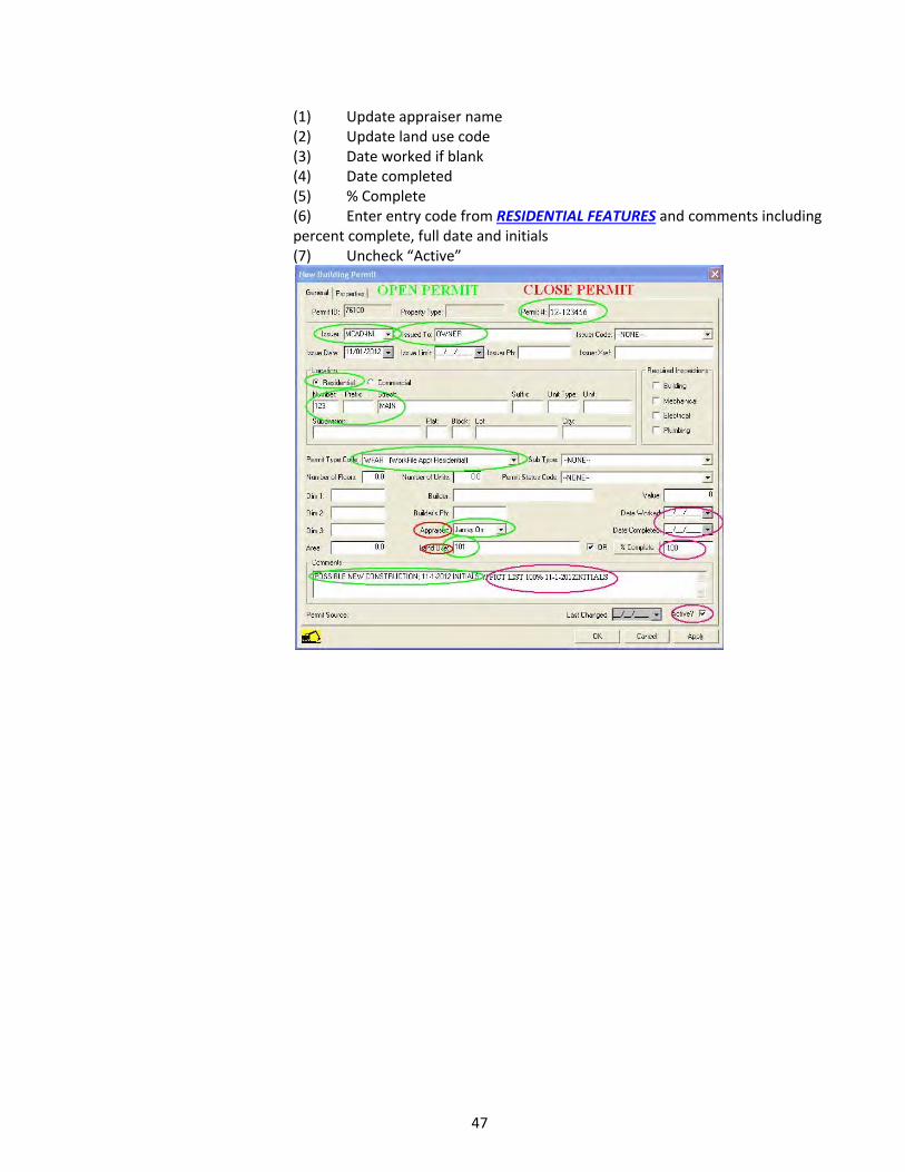
47
(1) Update appraiser name (2) Update land use code (3) Date worked if blank (4) Date completed (5) % Complete (6) Enter entry code from RESIDENTIAL FEATURES and comments including percent complete, full date and initials (7) Uncheck “Active”

48
C. FIELD OPERATIONS PROCEDURES
The MCAD BUILDING PERMIT WORKSHEET is a MS Access form developed “in‐house” by the Residential and Commercial Departments to replace the BPS Worksheets setup in the PACS software. The MCAD form is an essential field work tool for organizing and capturing data on properties affected by permits.
The MCAD Worksheets are used by both departments for capturing daily field work. An appraiser must have a current Property field Review Card (PRC) card with every worksheet when performing field work.
The Technology Department (TD) prints residential BPS worksheets using MS Access reports based on preset queries, which prompt the clerk to enter specific criteria. TD builds BPS packs based on neighborhoods, and the completed packs are assigned to Field Ops appraisers to work.
Appraisers write all changes and/or additions to the worksheet, summary report and PRCs in red ink, so they can be easily identified by the data entry clerks. Sketches and any field notes the appraiser makes for their own use are written in pencil.
Field permits are made by the appraiser when they ‘discover’ new improvements, an addition or changes to a property not covered by an existing BPS worksheet when performing field work.
The following pages show examples of these forms along with instructions on how to capture and/or update all pertinent data during field operations. It is divided into 3 sections: 1.) BPS New Construction, 2.) BPS Existing Construction, and 3.) BPS Field Permits (discovery). Once the appraiser has completed either the worksheet or Report as part of their daily field work and attached photos associated with the property, the forms are turned into the TD for data entry or the appraiser may do their own data entry. Permits turned in to the TD require more detail as indicated below, and less data if the appraiser will be entering directly into PACS. However, the same information is required in PACS whether or not it was written on a permit. After a clerk has completed all data entry and sketching from the BPS forms and PRC cards they are returned to the Residential Supervisor for review.
1. FIELD MEASUREMENT AND SKETCHING
a) Verify Situs (Address) b) MCAD Identification
Introduce yourself if anyone is at home, as an employee of the CAD and the purpose of your visit
c) Request Access To Property And Inquire About Interior Features
Ask how many rooms/bedrooms/baths the property has and if you may enter the back yard
d) Photograph Improvements e) Sketch All Improvements Except:
Bathrooms, driveway, fence, pool, terrace surrounding pool
f) Measure g) Verify Old Improvements And List New
List Space is provided on permits to make a scale diagram of each structure being appraised. Only the perimeter walls of buildings are indicated on the diagram unless an interior wall represents a change in use type, construction type, quality, or floor level. Following are examples and guides to aid the appraiser in the proper recording and diagramming procedures. It is important that the diagram be clear and accurate so that it can be readily interpreted by data entry. The number of stories in a building is always recorded within the applicable area of the diagram by writing the number within a circle. Examples for distinguishing between one story, one and one‐half story, and two story residential buildings are illustrated as follows:

49
Structures should always be drawn with the front at the bottom of the diagram space. The building should be measured starting from an appropriate corner or feature continuing around the structure until arriving back at the start point, recording each dimension to the nearest inch on the building permit. If obstructions prevent measuring directly against the building, the appraiser retreats to an unobstructed parallel path and measures by sighting to the corners of the wall being measured.
Structures are measured to the nearest foot using exterior dimensions for the ground floor in accordance with IAAO Standard on Mass Appraisal of Real Property:
3.3.2.4 Data Accuracy Standards • The following standards of accuracy for data collection are recommended. • Continuous or area measurement data, such as living area and exterior wall
height, should be accurate within one foot (rounded to the nearest foot) of the true dimensions or within 5% of the area.
On two story homes use exterior dimensions for the 2nd floor if the exterior wall sits directly over the first floor wall or the boundaries are evident, minus openings for stairwells. For 2nd stories that are irregular shaped compared to the first floor use interior measurements of actual floor space including closets and hallways if interior is accessible and draw 2nd story diagram to the side of the first floor to eliminate confusion with the floor number circled. Also, circle a corresponding corner of the first and second floor if they align to indicate where to locate the second floor in reference to the first (see figure 3). If the interior is not accessible, estimate the area that could be used for 2nd story based on the roofline. For non 90° corners use a rise over run technique as this is how it is entered into PACS, annotate this with a “^” symbol with the corresponding measurements on either side of the “^”(see figure 2 and 3). Optionally, the Pythagorean Theorem (A² +B² =C²) is useful to verify your measurements since C² will be your measured wall length.
Garages are indicated on diagrams by using a circled “G” (see figure 2). Porches are indicated with a diagonal line. Other improvements are labeled using their Type Code or Class to distinguish them. On multiple improvements with additional features (ie. 3x barns) number the improvements on the diagram and the listed features. After all measurements have been gathered calculate the sum of the feet separate from the inches for each side individually. Divide the total number of inches by twelve and add it to the feet sum. The remainder of the inches will be rounded off to the nearest foot. The opposing sides should be equal unless the improvement is obviously not square. The purpose of calculating inches separately is to prevent inadvertently rounding up or
Figure 1

50
down 2 or 3 feet. After ensuring the diagram is square re‐label the diagram using a red pen for Data Entry. See diagram below:
Figure 2

51
Figure 3

52
2. MCAD BUILDING PERMIT WORKSHEETS
1. New Construction ‐Residential Worksheet example – Front
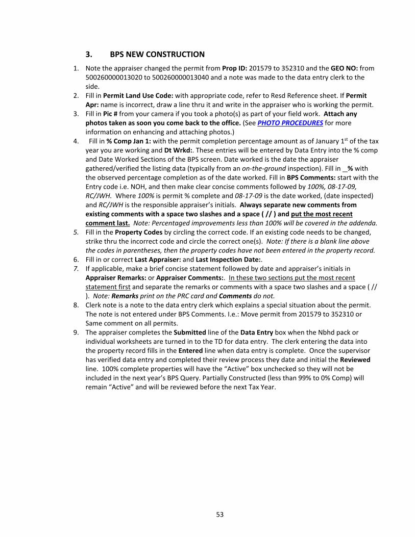
53
3. BPS NEW CONSTRUCTION
1. Note the appraiser changed the permit from Prop ID: 201579 to 352310 and the GEO NO: from 500260000013020 to 500260000013040 and a note was made to the data entry clerk to the side.
2. Fill in Permit Land Use Code: with appropriate code, refer to Resd Reference sheet. If Permit Apr: name is incorrect, draw a line thru it and write in the appraiser who is working the permit.
3. Fill in Pic # from your camera if you took a photo(s) as part of your field work. Attach any photos taken as soon you come back to the office. (See PHOTO PROCEDURES for more information on enhancing and attaching photos.)
4. Fill in % Comp Jan 1: with the permit completion percentage amount as of January 1st of the tax year you are working and Dt Wrkd:. These entries will be entered by Data Entry into the % comp and Date Worked Sections of the BPS screen. Date worked is the date the appraiser gathered/verified the listing data (typically from an on‐the‐ground inspection). Fill in % with the observed percentage completion as of the date worked. Fill in BPS Comments: start with the Entry code i.e. NOH, and then make clear concise comments followed by 100%, 08‐17‐09, RC/JWH. Where 100% is permit % complete and 08‐17‐09 is the date worked, (date inspected) and RC/JWH is the responsible appraiser’s initials. Always separate new comments from existing comments with a space two slashes and a space ( // ) and put the most recent comment last. Note: Percentaged improvements less than 100% will be covered in the addenda.
5. Fill in the Property Codes by circling the correct code. If an existing code needs to be changed, strike thru the incorrect code and circle the correct one(s). Note: If there is a blank line above the codes in parentheses, then the property codes have not been entered in the property record.
6. Fill in or correct Last Appraiser: and Last Inspection Date:. 7. If applicable, make a brief concise statement followed by date and appraiser’s initials in
Appraiser Remarks: or Appraiser Comments:. In these two sections put the most recent statement first and separate the remarks or comments with a space two slashes and a space ( // ). Note: Remarks print on the PRC card and Comments do not.
8. Clerk note is a note to the data entry clerk which explains a special situation about the permit. The note is not entered under BPS Comments. I.e.: Move permit from 201579 to 352310 or Same comment on all permits.
9. The appraiser completes the Submitted line of the Data Entry box when the Nbhd pack or individual worksheets are turned in to the TD for data entry. The clerk entering the data into the property record fills in the Entered line when data entry is complete. Once the supervisor has verified data entry and completed their review process they date and initial the Reviewed line. 100% complete properties will have the “Active” box unchecked so they will not be included in the next year’s BPS Query. Partially Constructed (less than 99% to 0% Comp) will remain “Active” and will be reviewed before the next Tax Year.

54
New Construction ‐Residential Worksheet Example – Back
The following fields are required to be filled in when doing field work: 10. Select the appropriate New Value: box. The example is a new house on a previously vacant lot,
so the Improv box is checked. 11. Fill in the blanks on line 2. Type: should be R for residential, State Code: should be A1 for single
family, Hm Site: should be 100 or Y for single family, Effective Year Blt: Typically the year of construction, Comment: Include the same improvement comments that you would in PACS. Ex: (LIST NEW SFR YYYYinitials) or (LIST 447X2, RMV 031;2013initials)
12. Adj factor‐ line is for adjustments made at the improvement segment level. Any adjustment made must be followed by Adj reason: with a brief note, date and initials for the adjustment i.e. 20% phys for cracked slab, 07‐17‐09, RC. % Comp is as of January 1st of the Appraisal year.
13. Is the section where the main area and additive details of the residence are entered. Fill in Type, Mth, Class and YR Blt. Eff Year is for effective year built. Never fill in this box unless you want an improvement to have a different effective year and depreciation rate from the Imp Segment Level Eff Yr entered in Effective Year Blt: in section 11.
14. Write the correct Improvement Features for each item. Note: Flooring may have more than one entry. In residential listings the features are entered under the first floor main area. Refer to RESIDENTIAL FEATURES worksheet for appropriate codes.

55
15. This area captures required Mobile Home Manufacturer, Model, HUD No. and SN# information. Physical attribute Information such as the Mobile Home details, additives and OB&Ys are listed in the same manner as single family and multi‐family dwelling structures.
16. The Room Count‐Rent section (may not be on all versions) is where pertinent market data is captured multifamily properties. In this example # Units is 1 since this is a single family residence, Tot is 8 for total number of rooms excluding baths, Bd is 3 for the number of bedrooms, Ba is 2 for the number of full baths and Hba is – or 0 for the number of half baths. $Mo is for the monthly rent per unit, since this is a single family owner occupied house it is left blank. For multi‐family list the number of units and room count for each type of unit (unit mix) in the blanks provided. If it has 3 or more unit mix, list them in the space below the boxes.
17. Is the sketch area for drawing the foot print and making notes of the improvements.

56
Field Review Card – Residential
A current Field Review Card (PRC) is printed for every property worked in BPS, for use in verifying and/or changing any land or improvement items.
18. In our example the land state code was changed from C1 to A1. Common mistakes include not correcting state codes from O1 to A1, A1 to A3 or E1 to E3.

57
4. BPS EXISTING CONSTRUCTION
The next example is a permit issued on an existing improvement. Common permit types for an existing residence are remodel, demo, fire report, general repairs, and red tagged or work file.
An appraiser must have a current PRC card with every worksheet when performing field work. Typically when doing field work on existing improvements all data and/or changes are captured on the front of the worksheet and on the PRC card. Changes and/or additions are written in red ink so they can be easily identified by the data entry clerks.
In the next example the back page of the permit worksheet is not shown since all changes to the improvement were made on the PRC card.

58
Existing Improvement ‐ Residential Worksheet Example – Front

59
1. Fill in Permit Land Use Code: with appropriate residential code. If Permit Apr: name is incorrect, draw a line threw it and write in the appraiser who is working the permit.
2. Fill in Pic # from your camera if you took a photo(s) as part of your field work. Attach any photos taken as soon you come back to the office. (See PHOTO PROCEDURES for more information on enhancing and attaching photos.)
3. Fill in or correct Last Appraiser:, Last Inspection Date:, then; if needed, comments in Appraiser Remarks:.
4. Fill in % Comp Jan 1: with the permit completion percentage amount as of January 1st of the tax year you are working and Dt Wrkd:. These entries will be entered by Data Entry into the % comp and Date Worked Sections of the BPS screen. Date worked is the date the appraiser gathered/verified the listing data (typically from an on‐the‐ground inspection). Fill in % with the observed percentage completion as of the date worked. Fill in BPS Comments: start with the Entry code i.e. NOH, and then make clear concise comments followed by 100%, 08‐17‐09, RC/JWH. Where 100% is permit % complete and 08‐17‐09 is the date worked, (date inspected) and RC/JWH is the responsible appraiser’s initials. Always separate new comments from existing comments with a space two slashes and a space ( // ) and put the most recent comment last.
5 . The appraiser completes the Submitted line of the Data Entry box when the Nbhd pack or individual worksheets are turned in to the TD for data entry. The clerk entering the data into the property record fills in the Entered line when data entry is complete. Once the Residential Supervisor has verified data entry and completed their review process they date and initial the Reviewed line. Partially Constructed (less than 99% to 0% Comp) is placed in the Nbhd Pack to be re‐inspected in the next BPS Phase.
Remember to: Verify all the fields on the front of the worksheet. You are responsible for all existing
information on the worksheet and PRC just as if you had listed the property for the first time. Check Situs:, Neighborhood: and Region: do they need to be changed or entered? Make sure the Permit #: is filled in using the correct year format. Check the Permit Type: making sure it has the correct residential or commercial coding. Verify that all the Property Codes are up to date and entered correctly. Make sure that the data in Appraiser Comments: and Appraiser Remarks: is pertinent, meaningful, dated and initialed.
**Every property must have a Situs, Nbhd and Region.**
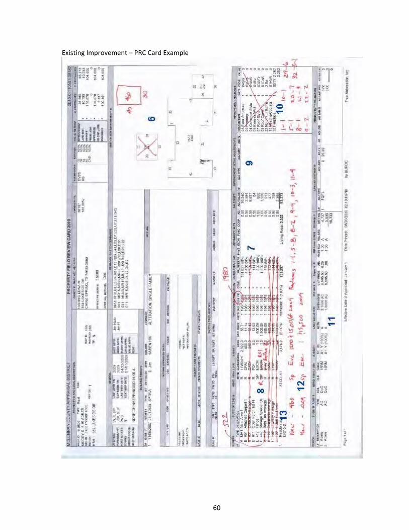
60
Existing Improvement – PRC Card Example

61
6. In the existing sketch, if there is room, draw where the new improvement or addition is located along with measurements and any needed notes.
7. Mark any improvement segments that need to be deleted from the property record. 8. Change the listing to all current codes and schedules. In this example the 447 code for
storage is changed from method SP to R and class from EXCP to RS1. Also the individual plumbing codes are converted to bathroom codes. Here the 112 bathtub code is converted to 522 bathroom average and class from BTA to BATHA. The 122, 132 and 105 codes are deleted.
9. Review the improvement adjustments and change or add any as needed. 10. Review the features and change or add any as needed. In this example the features
were relisted to current standards; refer to the Resd Features Reference sheet. 11. Review the land information making any needed changes. 12. Add any new items under a heading of New or Add. In this example a New heading is
used so the data clerk knows to check the New Value Improvement Detail button and check the New Value check box under the item detail. Then as in the example write in the item code, method, class, unit price ($25 for a 465/gazebo), year built and any Features that apply.
13. Verify the Comment and change as needed. Remember to: Verify all the improvement details on the card such as Class, Year built, Effective year built,
Physical, Economic, Functional and % Complete and change and/or add as needed to reflect the current condition of the improvements as of the date worked. Also check for any changes to the property not listed on the permit such as an enclosed garage, addition etc.
Your date and initials indicate that you agree with everything listed on the PRC (both new and existing) and you are accepting full responsibility for the inventory data.

62
5. FIELD PERMITS ‐ DISCOVERY AT ITS BEST
Field Permit (Discovered) – Resd Worksheet Example ‐ Front

63
a) Appraisers always carry several blank copies of a current BPS worksheet when working in the field. The appraiser makes a Field permit by filling in a blank worksheet when they ‘discover’ new improvements, an addition or changes to a property not included on an existing BPS worksheet/BPS Nbhd pack. Once the appraiser returns to the office they can review the ‘discovered’ property to confirm if there is an existing and/or mismatched permit that covers the observed changes listed on the Field permit. b) If needed the appraiser updates the Field permit or if the observed changes were related to an existing permit they add the new information with clear instructions for data entry. ‘Discovered’ changes are then forwarded to data entry to create a new permit or workfile as needed. The Supervisor will determine if the ‘discovered’ permit will be added to the existing actively assigned BPS pack or if it will cycle to the next BPS Phase. In any event, TD/RFOS Supervisor will print a worksheet and a PRC card for updating the appraisal record with the ‘discovered’ items. c) Example of a Minor Change (Fast Tracked): d) In the preceding example of a field permit; the appraiser while working in the field noticed the house at 1037 South Haven had changed the rear terrace to a porch. A blank BPS worksheet was filled out with all the information that could be gathered in the field. The appraiser returns to the office and they retrieve the affected property with the PACS ‘Open Property Icon’ by address and review the listed data. e) If there was not an existing permit; such as a city issued permit, on the property for the discovered changes, the appraiser would update the field permit. They would fill in Prop ID: and Permit #:. In this example the permit # would be 09‐149677. A PRC card would be printed with all changes made using current listing standards. Then both would be placed in the existing BPS pack and turned in for data entry. f) If there was an existing permit such as a city permit, the appraiser would ‘print screen’ the existing permit, write a note on it saying see the attached permit and PRC card then turn in all three with the BPS pack for data entry. g) All BPS field work follows the same data entry process and current listing standards as described in the preceding pages, no matter what the source whether city, MCAD, field permit, etc.

64
D. QUALITY CONTROL
Residential appraisers work schools in the reappraisal plan by neighborhoods. As they finish, they document the date finished on the project board. As these neighborhoods are finished, each one is put through a series of queries to define whether they have followed code sheets and directions to reappraise properties. Any problem or miscoding is returned to each appraiser for correction. After corrections the queries are re‐run to ensure that all corrections were completed.
The goal of these queries is to achieve no less than a 95% rate of accuracy on objective data and 90% for subjective data. The queries are divided into two groups, appraiser run and supervisor run queries. Supervisors run both sets of queries to double check.
1. APPRAISER QUERIES
Below are examples of queries available to appraisers. Some queries may be run prior to working a NBHD and discrepancies are corrected from an active list.
a) Checking remarks are entered into each account with year and initials b) List the appraiser’s information data c) Coding for percent completes that may still be on accounts d) List to determine all accounts given additional physical, functional and economic depreciation have reason, year and initials e) Adjustment codes that may appear on the Improvement Detail. Adjustment codes must include description, year and initials f) Accounts that still have a flat value or special value instead of being on a schedule g) Adjustment codes that appear on any individual part of a property h) List to check the improvement comments telling what has been done to the account in that appraisal year i) Active Building Permits
2. SUPERVISOR QUERIES
Below are examples of queries run by the supervisor or Assistant Chief. Depending upon the goals of the reappraisal cycle and any special projects during the year this list may be modified on a yearly basis.
a) List accounts with no sketch drawing b) Coding for driveways c) List of fences d) Old coding for bathrooms e) Coding for old codes that were used that have been done away with f) Coding for barns g) Coding for pools that should be changed from a flat value to the schedule for that type of pool or spa that they are
3. END OF YEAR QUERIES
a) Gain/Loss b) New Value errors c) Baylor Homestead Land values
65
E. RATIO STUDY PROCEDURES
McLennan County Appraisal District performs its ratio studies in accordance with IAAO standards and the Uniform Standards of Professional Appraisal Practices (USPAP).
Each year, ratio studies are conducted on each residential market area within the district to judge the two primary aspects of mass appraisal accuracy—level and uniformity of value. Only verified arms‐length transactions are included in the ratio studies. Outliers are identified and researched and either adjusted or excluded from the ratio study.
Ratio studies are produced by school district, by classes, by neighborhoods and other criteria prior to
beginning the reappraisal process. This analysis is used to develop the starting point for establishing the level and accuracy of appraisal performance; and to also indicate the uniformity or equity of existing appraisals. Mean, median and weighted mean ratios are calculated for properties in each reporting category and market area to measure the level of appraisal (appraisal accuracy.) The coefficient of dispersion (COD) is calculated to measure appraisal uniformity by property reporting category and market area.
Market areas that have low or high ratios or a high coefficient of dispersion are determined to be
problematic. Field reviews are scheduled to verify and/or correct property characteristic data in these areas. Additional sales data is researched and verified. In the absence of adequate market data, neighborhood delineation is verified and neighborhood clusters are identified. Based on the ratio studies, schedules, modifiers and neighborhood factors are adjusted as necessary. This process requires that many of the ratio studies be re‐run numerous times to determine effects of the adjustments.
Upon completion of analysis, a set of ratio studies is also produced prior to the generation of appraisal
notices. The Appraisal Review Board is provided with a set of School District Ratio Studies as a means of supporting appraisal uniformity.
A final set of ratio studies is produced upon the completion of appraisal review hearings. This set of
studies is compared to the set produced prior to generation of appraisal notices. This comparison provides the district with information concerning low and high protest areas and the effects of value changes made by the Appraisal Review Board and assists the district in planning and effective reappraisal decisions for the upcoming year.
F. PROCEDURES FOR PHOTOS
1. TAKING PHOTOS
Verify that the date stamp is on when you first receive your camera. Photos should be taken with the entire subject centered in the frame. Preferably take the photo at an angle so the front and one side are visible. If the subject is extremely large multiple close up photos may be necessary to get sufficient detail along with an overall shot from further away. Photograph any outbuildings or features that may not be visible from Pictometry.
2. DOWNLOADING
Attach the USB cable to your camera and computer. Turn the camera power on and the appropriate software should launch allowing you to import images (if not ask another appraiser or the IT Dept. if you can’t find the import software). Delete the images from your camera after verifying they were copied.

66
3. ENHANCING
Microsoft Office Picture Manager works well if you need to crop, lighten or darken a photo. To use right click on the desired image and select “open with”, “Microsoft Office Picture Manager”. Make any necessary adjustments to the photo but do not crop out the date stamp.
4. ATTACHING
Verify the location of the property you photographed matches the PID you believe by comparing each photo to Pictometry. Consult with Mapping if a discrepancy appears based on property lines splitting an improvement.
a) Individual Images:
Open the property, click on “Images” tab, “New” button, select appropriate Image Type, Record Type, and Sub Type (usually “Photo”, “Improvement”, “Front”), select radio button “Select an existing image”, “Browse”, Find the image where you stored on your computer, “Open”, and “OK”.
Find the Images you uploaded in the preview screen in the “Images” tab, select one as “Main Image” and click apply. You may have to click recalculate if you don’t see your images.
b) Mass:
Mass Upload allows you to upload multiple photos under the same heading (Photo/Improvements/Front etc. ) to one or multiple properties. On the main PACS drop down menu click “Activities”, “Quick Image Scan”, “Quick Image Standard”. In the new window type in the PID for the first account, select “Quick Add”, repeat adding properties if all images belong to all properties. Select appropriate Image Type, Record Type, and Sub Type. Click “Select Existing Images” radio button, Browse to the appropriate photos, select multiple photos by holding down the “CTRL” key. Select “Main Image” box if the first photo is the primary photo that will be displayed on the field card. Click “OK” to upload. A popup window will ask if you have additional properties that you would like to add images to.
G. PROCEDURES FOR GREETING & ASSISTING TAXPAYERS
When greeting taxpayers whether you are on the phone or in person ALWAYS SMILE!!! You can hear it in your voice if you’re smiling. When assisting with rendition forms, the taxpayer is REQUIRED to do the writing on the forms unless you have received prior authorization from the supervisor to do the writing for them. Always ask for a phone number in case we need to contact them via telephone. When assisting with address changes, bring up property, click on the “Owner‐Agent” tab and click “details”. Then on the browser click on “taxpayer” scroll down to “Print Owner Letter”. Make sure the letter space shows “Mailing Address Change Form” Click OK. Have them fill this out, and make sure you put the account number on the top right hand side of the sheet.

67
H. PROCEDURES FOR INFORMAL MEETINGS
1. DATA CLERKS
When a taxpayer calls to make an appointment, an inquiry is setup in that account. The data clerk determines what appraiser worked this account by reviewing the last appraiser in the appraiser info tab in PACS. Once this is determined the data clerk schedules an informal appointment with that appraiser by utilizing a scheduling system in PACS. When a taxpayer comes in to speak with an appraiser an appointment is scheduled immediately or as time allows.
2. APPRAISERS
When the appraiser arrives each day he/she will check their schedule for their daily appointments. When a taxpayer arrives at the office, they will be greeted by a data clerk. The data clerk will advise the appropriate appraiser that the taxpayer has arrived and the name of the business they are representing. The appraiser has previously reviewed the account under protest in PACS and has determined what will be discussed. The taxpayer is taken to the appraiser’s area and the appraiser goes over the current protested issue with the taxpayer. The appraiser addresses any issues and answers any questions at this time. The appraiser will also correct any clerical errors or over site mistakes, as well as any documentation presented by the taxpayer. The appraiser will document any changes in the appraiser information screen in the PACS system. A Value Agreement or Settlement & Waiver of protest is then generated by the PACS system and will also contain the reason for change in value. This Settlement & Waiver of protest must first be reviewed and approved by the supervisor before being signed by the taxpayer.
3. INFORMAL PROCESS PROCEDURES
a) Watch the Inquiry Sign In monitor for taxpayer arrivals and be ready to go at 8:00. b) Do not skip, sort thru accounts, or sit at your desk preparing a defense before you get a taxpayer. c) Take the next taxpayer on the list unless they have been assigned to a specific appraiser. d) Determine the taxpayer’s issue. e) Review the account thoroughly using Pacs, Pictometry and Google earth if necessary. f) Look at Appraiser Info and Deed‐Sales tabs to determine if it is for sale, recently sold and what type of sale occurred. g) Check for previous adjustments ( Phy, SCM, Etc…) h) Check the Permit tab for any new or recent upgrades. i) Prepare a comp/equity grid in Pacs to determine if the market value of property is correct.
68
(1) SALES INFORMATION IS CONFIDENTIAL!‐Use the “System Wide‐INFORMAL” grid if the taxpayer asks to see sales. They must have a formal protest filed and requested the evidence to get all the information on sales comparables used to value their property. (2) Be sure to save your final grid so if a protest is filed, a grid will already exist on the property. (3) If you cannot support the value do not send them on to file a protest. Check with the Supervisor, Asst. Chief or Chief appraiser to see if a resolution can be reached.
j) If making a market or equity adjustment use the SCM adjustment in the improvement details screen. k) If the property owner claims there is physical problems with the property they must have evidence to support it.
(1) If you add a physical adjustment be sure to put comments in the “physical” tab in pacs. (2) Be sure that the taxpayers evidence is scanned to the account
l) If an agreement is reached you must get a signed Value Agreement before they leave the office and the changes must be approved by the Residential Supervisor, Asst. Chief or Chief Appraiser. m) Make sure that the Appraiser Assigned Value and Reason Code are filled out in the Inquiry value screen. n) If an agreement is not reached then you need to courteously bring the informal meeting to a close. o) Do not help them fill out a protest form or walk them thru the process.
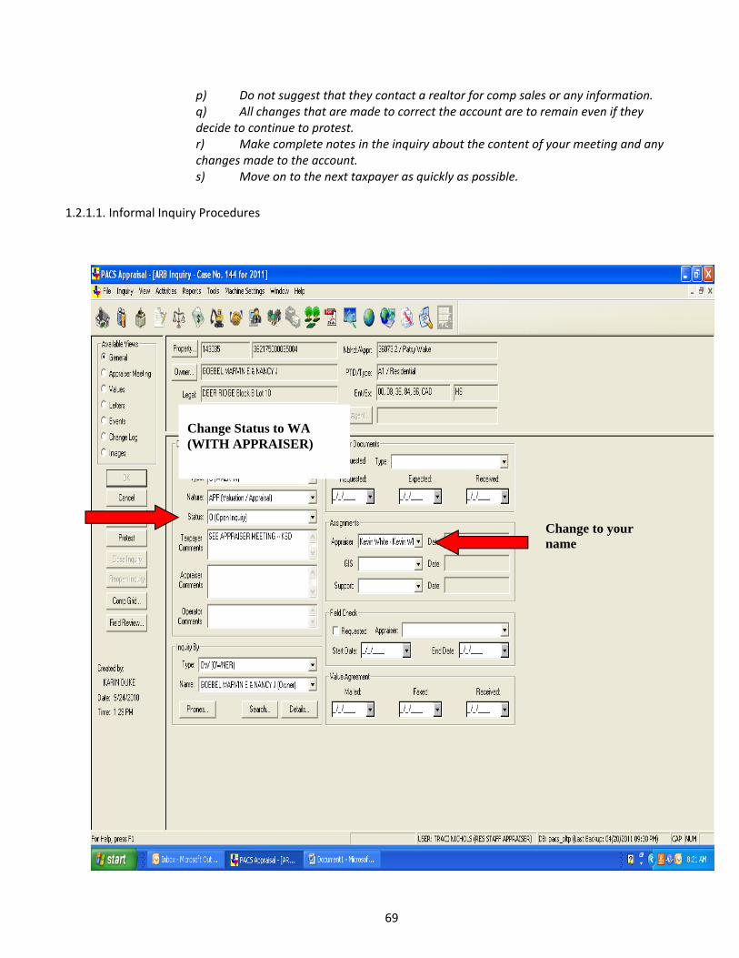
69
p) Do not suggest that they contact a realtor for comp sales or any information. q) All changes that are made to correct the account are to remain even if they decide to continue to protest. r) Make complete notes in the inquiry about the content of your meeting and any changes made to the account. s) Move on to the next taxpayer as quickly as possible.
1.2.1.1. Informal Inquiry Procedures
Change to your name
Change Status to WA (WITH APPRAISER)

70
Enter comments for any changes or no change made to the account

71
Change Status accordingly: NCI, RP, VAP
Enter determined value, even if no change
Select appropriate reason for change or no change

72
4. ONLINE PROTEST PROCEDURE
a) Click “HANDSHAKE” then click “PROTEST” b) Year: current tax year c) Click “ACTIVE” then click “SEARCH”
Print 2 Value Agreements if change made

73
d) Click “STATUS” to move EPF to top of page if any e) Double click EPF to open f) Change status on protest page from EPF to EPWIP g) Read comments on protest page h) Create sales and equity grids accordingly i) “PRINT GRID” to PDF j) Save as “PID#‐SALES COMP GRID” and/or “PID#‐EQUITY COMP GRID” k) Close PDF windows of comp grids l) Minimize PACS screen m) Open desktop folder for online protests n) Right click mouse and create new folder o) Name it PID# of the property on the protest p) Drag the PDF comp grids into the folder q) Maximize PACS screen r) Go to protest page and click “EVIDENCE” s) Enter PID# in “PACKET DISPLAY NAME” t) Click “ADD” in “NEW EVIDENCE PACKET CONTENTS” u) Go to desktop online evidence folder v) Locate correct PID folder and double click it w) Double click the PDF comp grid x) Repeat steps 23 – 26 for additional comp grids y) Make sure PID# is in “PACKET DISPLAY NAME” then click “CREATE PACKET” z) Packet should be in “ARB PROTEST EVIDENCE” aa) Click on the packet and it will turn blue then click on “VIEW” bb) When packet opens, click on “TOOLS” then click on “INSERT FROM FILE” cc) Go to desktop online evidence folder dd) Double click “ON‐LINE APPEALS – AGREEMENTS MCAD…” ee) Click “BEFORE” in small window then click “FIRST” then click “OK” ff) Save file and close window gg) Go to the evidence page and click “PUBLISH” hh) Now click “VALUES” on the protest page ii) Click “ONLINE SETTLEMENT” box jj) If you have an offer click “OFFER AMOUNT” and enter amount kk) If you have no offer click “NO SETTLEMENT OFFER” ll) Change status from EPWIP to EPSO if an offer is made or mm) Change stutus from EPWIP to EPS if no offer is made nn) Click “APPLY” oo) Click on “APPRAISER MEETING” pp) Enter notes regarding the offer or no offer
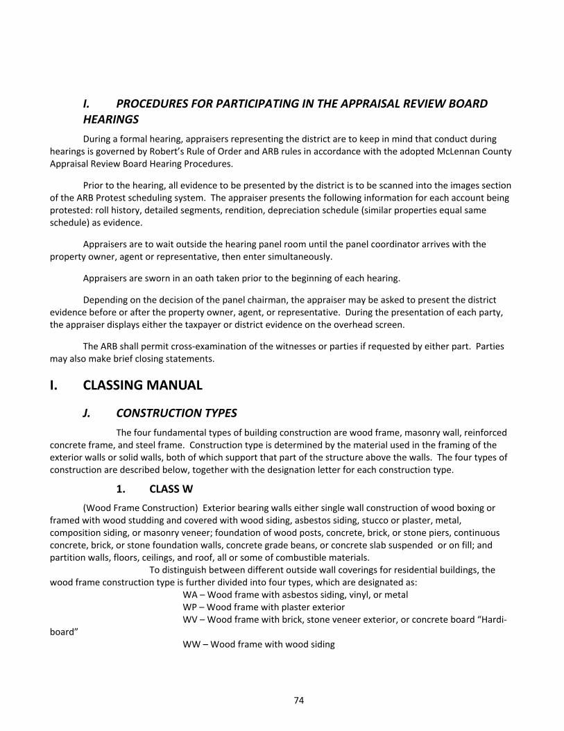
74
I. PROCEDURES FOR PARTICIPATING IN THE APPRAISAL REVIEW BOARD HEARINGS
During a formal hearing, appraisers representing the district are to keep in mind that conduct during hearings is governed by Robert’s Rule of Order and ARB rules in accordance with the adopted McLennan County Appraisal Review Board Hearing Procedures.
Prior to the hearing, all evidence to be presented by the district is to be scanned into the images section of the ARB Protest scheduling system. The appraiser presents the following information for each account being protested: roll history, detailed segments, rendition, depreciation schedule (similar properties equal same schedule) as evidence.
Appraisers are to wait outside the hearing panel room until the panel coordinator arrives with the property owner, agent or representative, then enter simultaneously.
Appraisers are sworn in an oath taken prior to the beginning of each hearing.
Depending on the decision of the panel chairman, the appraiser may be asked to present the district evidence before or after the property owner, agent, or representative. During the presentation of each party, the appraiser displays either the taxpayer or district evidence on the overhead screen.
The ARB shall permit cross‐examination of the witnesses or parties if requested by either part. Parties may also make brief closing statements.
I. CLASSING MANUAL
J. CONSTRUCTION TYPES
The four fundamental types of building construction are wood frame, masonry wall, reinforced concrete frame, and steel frame. Construction type is determined by the material used in the framing of the exterior walls or solid walls, both of which support that part of the structure above the walls. The four types of construction are described below, together with the designation letter for each construction type.
1. CLASS W
(Wood Frame Construction) Exterior bearing walls either single wall construction of wood boxing or framed with wood studding and covered with wood siding, asbestos siding, stucco or plaster, metal, composition siding, or masonry veneer; foundation of wood posts, concrete, brick, or stone piers, continuous concrete, brick, or stone foundation walls, concrete grade beans, or concrete slab suspended or on fill; and partition walls, floors, ceilings, and roof, all or some of combustible materials.
To distinguish between different outside wall coverings for residential buildings, the wood frame construction type is further divided into four types, which are designated as:
WA – Wood frame with asbestos siding, vinyl, or metal WP – Wood frame with plaster exterior WV – Wood frame with brick, stone veneer exterior, or concrete board “Hardi‐
board” WW – Wood frame with wood siding

75
2. CLASS M
(Masonry wall construction) Exterior bearing walls of masonry units such as brick, stone, tile, or concrete block; foundation of concrete, brick, or stone continuous walls, concrete grade beams, or concrete slab suspended or on fill; and partition walls, floors, ceilings, and roof, all or some of combustible materials.
3. CLASS C
(Reinforced concrete construction) Exterior walls of solid reinforced concrete or wall framing of reinforced concrete columns and beams with curtain walls of masonry units, steel panels, or reinforced concrete slabs; foundation of reinforced concrete pier and beam or concrete slab suspended or on fill; roof structure of reinforced concrete or steel frame construction; and partition walls, floors, ceilings, and roof of noncombustible materials.
4. CLASS S
(Steel frame construction) Exterior wall framing of structural steel with curtain walls of masonry units, steel panels, or reinforced concrete slabs; foundation of reinforced concrete pier and beam or concrete slab suspended or on fill; roof structure of steel truss or rigid frame construction; and partition walls, floors, ceilings, and roof of non‐combustible materials.
K. QUALITY OF CONSTRUCTION
1. RESIDENTIAL STRUCTURES
The foregoing classes for use types and construction types are finally divided into classes denoting quality. Numbers are used to denote the quality of buildings, with the number “1” for the lowest quality and higher numbers representing progressively better buildings.
Specifications of the typical structures making up the classification system are provided for the normal range of quality existing in all use and construction types. Buildings of a quality that are adjudged to be less than “1” are not appraised by classification but are appraised at a lump‐sum value. Buildings of a quality that are adjudged to be greater than the range that is provided are likewise not appraised by classification but are appraised as a special building, using as guides the schedules of the classification system.
The numbers designating quality are further expanded by introducing a + (plus) and a ‐ (minus) between the numbers denoting quality to indicate qualities that are slightly better or slightly less than that described by the basic specifications. To classify a building according to quality, therefore, the basic quality designation number is determined by relating the subject building to the proper basic specifications and then, by exercising careful judgment, determining whether the subject building’s quality is equal to, in excess of, or less than that prescribed by the specifications.
2. Additional Details Additional details comprise all parts of buildings not included in the specifications of the basic
structures and are not included in the value covered by the classification. There are three items of additional details that are classified independently of the class for the basic structures. These are porches, garages, and carports. Unclassified items include heating and cooling, plumbing, and a variety of others.
2. PORCHES
The classification of porches, in addition to construction type and quality, is according to their characteristics as to extent of being enclosed or open. The designation letters for enclosure or openness are:
PO (Open) Without walls or windows; may have screen wire; and may or may not have supporting columns or posts.

76
PCU (Closed Unfinished) With walls and windows; exterior wall finished, exposed interior walls and ceiling; and common wall of building and unfinished porch usually of the same material as building proper.
PCF (Closed finished) With walls and windows; exterior walls, interior walls, and ceilings finished; and common wall of building proper and finished porch usually of same material as interior of closed finished porch.
3. GARAGES
The classification of garages is in accordance with their construction type and quality in the same manner as basic structures are classified. The material used in the framing of the exterior walls is again the determining feature for selecting the letters designating the construction types. The quality, again as in basic buildings, is denoted by a numeral following the letter designating the construction type; and it, too, may have a + (plus) or – (minus) to indicate the variations in quality from the class.
4. CARPORTS
The only basis for the classification of carports is in accordance with their quality, which is indicated by the numerals with or without a + (plus) or – (minus). Inasmuch as exterior walls usually do not exist for carports; although there are usually one or more common walls with the main building, construction type is not required. The designation letters for carports are “CP”.
5. HEATING AND COOLING
Only heating and cooling installations that are permanently attached to the structure are considered to be real property. Space heaters and window cooling units are excluded. The schedules incorporate only equipment that is normally found in buildings. Unusual heating or cooling installations are valued individually, using the heating and cooling schedules for other types of equipment as guides.
There are three categories of heating and cooling installations as follows: Heating Floor furnaces, wall furnaces, suspended ceiling furnaces, and central heating plants, all of
which are described according to capacity stated in thousands of BTUs. Cooling Free standing units, central units for residential or small commercial and central units for multi‐
story apartment or commercial structures, all of which are described according to capacity in tons. Heating and Cooling Combination central units for residential or small commercial and multi‐story
apartment or commercial structures, all of which are described by size in tons.
6. BASIC SPECIFICATIONS AND PHOTOS

77
BASIC SPECIFICATIONS AND CONSTRUCTION DIAGRAMS OF A TYPICAL RESIDENTAL BUILDING
USE TYPE: 1-FAMILY DWELLING____________________________CLASS: 1 Very low Quality. One family dwelling of inferior materials, design, and workmanship. Unattractive in appearance. Single, box or reject/scrap masonry units in exterior walls; single or box partition walls; light wood frame or no ceilings; inferior concrete slab floors or single softwood floors; no special features; limited inferior plumbing installation. Considered substandard by today’s codes. FOUNDATION:
a. Footings – Concrete, masonry, or none.
b. Walls – None or scrap masonry units.
c. Piers and Beams – Wood or masonry block and light wood sills.
FLOORS:
a. Structure – Light wood joists or light concrete slab on fill
b. Flooring – Softwood or concrete slab.
c. Subfloor – None d. Finish – Paint or none
EXTERIOR WALLS:
a. Structure – Box or single wall, reject or scrap masonry units.
b. Outside Covering – Boxing, metal, asbestos, inferior plaster on wood frame or paint on masonry units.
c. Sheathing – None d. Insulation – None
ROOF:
a. Structure – Light wood rafters widely spaced.
b. Roofing – Rolled roofing, metal, or composition.
c. Sheathing – Solid or strip of inferior material.
d. Insulation – None
INTERIOR WALLS:
a. Structure – Single or box walls
b. Sheathing – Boxing c. Finish – Paint, paper or
none. d. Insulation – None
CEILINGS:
a. Structure – Light wood joists widely spaced, or none. b. Sheathing – Light wall board,
inferior lumber, or none. c. Finish – Paper, paint, or none d. Insulation – None
MILLWORK:
a. Windows – Wood plain rail b. Doors – Job built or light panel c. Trim – Stock lumber or none d. Built-Ins – None
ELECTRICAL:
a. Wiring – Romax or single wire b. Switches and Outlets – Few or none

78

79
Estimated year built 1940 ‐ 1950
Estimated year built 1950 ‐ 1959
Estimated year built 1950 ‐ 1959
Estimated year built 1930 ‐ 1939
Estimated year built 1930 ‐ 1940's Estimated year built 1930 ‐ 1939

80
Estimated year built 1930 ‐ 1939 Estimate year built 1940 ‐ 1959

81
BASIC SPECIFICATIONS AND CONSTRUCTION DIAGRAMS OF A TYPICAL RESIDENTAL BUILDING
USE TYPE: 1-FAMILY DWELLING____________________________CLASS: 2 Low Quality. One family dwelling of low quality materials, design, and workmanship; meeting minimum building code requirements. Plain and inexpensive in appearance, with little or no attention given to detail. Box constructed, light frame or inexpensive masonry units in exterior walls. Single box, light frame or low cost masonry units in partition walls; light wood frame ceilings; single wood or low quality concrete slab floors; no special features; minimum low cost plumbing installation. FOUNDATION:
a. Footings – Concrete or masonry. b. Walls – Wood, stucco,
inexpensive masonry, concrete, metal underpinning, or none.
c. Piers and Beams – Wood, masonry or concrete, light wood sills.
FLOORS:
a. Structure – 2 x 4 or 2 x 6 joists 24” o.c. or light concrete slab.
b. Flooring – 1 x 4 softwood or concrete slab.
c. Subfloor – None d. Finish – Paint, cheap covering or
none EXTERIOR WALLS:
a. Structure – Single wall, 2 x 4 studs 30” o.c., low grade concrete block, tile, brick, or stone.
b. Outside Covering – Boxing, wood, asbestos, plaster or cheap veneer on wood or plaster, paint or none on masonry.
c. Sheathing – Solid or strip of inferior material.
d. Insulation – None ROOF:
a. Structure – 2 x 4 rafters, 24” o.c.
b. Roofing – Rolled, metal, cheap wood or composition shingles.
c. Sheathing – Solid or strip of inferior material.
d. Insulation – None
INTERIOR WALLS: a. Structure – Single walls, 2 x 4 studs 30” o.c., or light masonry units. b. Sheathing – Boxing or light wall
board c. Finish – Paint, paper or none. d. Insulation – None
CEILINGS:
a. Structure 2 x 4 joists 24” o.c. b. Sheathing – Light wall board or inferior lumber. c. Finish – Paper or paint. d. Insulation – None
MILLWORK:
a. Windows – Wood single hung b. Doors - Light panel or Plywood c. Trim – Stock lumber or plain
mold d. Built-Ins – None or job built
ELECTRICAL:
a. Wiring – Romax or single wire b. Switches and Outlets – Few or
none
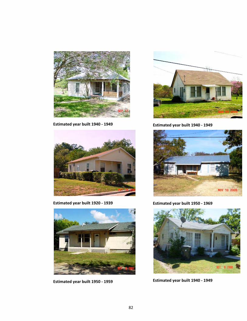
82
Estimated year built 1940 ‐ 1949
Estimated year built 1940 ‐ 1949
Estimated year built 1920 ‐ 1939
Estimated year built 1950 ‐ 1969
Estimated year built 1950 ‐ 1959
Estimated year built 1940 ‐ 1949

83
Estimate year built 1940 ‐ 1950
Estimated year built 1930 1939
Estimated year built 1930 ‐ 1949
Estimated year built 1940 ‐ 1949
Estimated year built 1940 ‐ 1949

84
BASIC SPECIFICATIONS AND CONSTRUCTION DIAGRAMS OF A TYPICAL RESIDENTAL BUILDING
USE TYPE: 1-FAMILY DWELLING____________________________CLASS: 3 Fair Quality. Frequently mass produced one-family dwelling of fair materials, design and workmanship. Low-cost production is primary consideration built to low minimum FMHA, FHA or VA standards. Fair in appearance. Framed or average masonry units in exterior walls. Framed, some single wall or masonry unit partition walls; wood framed ceilings; single, double wood or concrete slab on fill; limited special features; fair plumbing installations. FOUNDATION:
a. Footings – Concrete or masonry. b. Walls – Concrete or masonry,
stucco or wood underpinning. c. Piers and Beams – Concrete or
masonry piers, 4 x 6 or 4 x 8 sills FLOORS:
a. Structure – 2 x 4 or 2 x 6 joists 24” o.c. or concrete slab on fill.
b. Flooring –Softwood or hardwood, covering on concrete slab.
c. Subfloor – None or inexpensive lumber
d. Finish – Paint, varnish, or inexpensive covering.
EXTERIOR WALLS:
a. Structure –2 x 4 wood studs 16”-24” o.c., fair concrete block, tile, brick, or stone.
b. Outside Covering - Wood, plaster, asbestos, or masonry veneer.
c. Sheathing – Solid or strip with lumber, non on masonry or plaster, paint or none on masonry.
d. Insulation – None or inexpensive ROOF:
a. Structure – 2 x 4 rafters, 16” -24” o.c.
b. Roofing – Built up, wood or composition shingles.
c. Sheathing – Solid or strip of lumber.
d. Insulation – None
INTERIOR WALLS: a. Structure – Single walls, 2 x 4
studs 16”-24” o.c., or masonry units.
b. Sheathing – Shiplap or sheetrock, or none on masonry
c. Finish – Textone, paint, paper, and/or plaster or none on masonry
d. Insulation – None CEILINGS:
a. Structure 2 x 4 joists 16”-24” o.c.
b. Sheathing – Shiplap or sheetrock.
c. Finish – Textone, paint or paper.
d. Insulation – None or inexpensive
MILLWORK:
a. Windows – Wood or metal double or single hung, metal casements b. Doors panel or slab of softwood c. Trim – Plain milled of softwood d. Built-Ins – Cabinets milled or job built of softwood e. Quality – Inferior to average.
ELECTRICAL:
a. Wiring – Romax, single wire or conduit b. Switches and Outlets – Few or ample.

85
Estimated year built 2000 ‐ 2008 Estimated year built 2000 ‐ 2008
Estimated year built 2000 ‐ 2008 Estimated year built 1970 ‐ 1980
Estimated year built 2000 ‐ 2008 Estimated year built 1970 ‐ 1979

86
Estimated year built 1940 ‐ 1959 Estimated year built 1940 ‐ 1959
Estimated year built 1930 ‐ 1939 Estimated year built 1970 ‐ 1979
Estimated year built 1980 ‐ 1989 Estimated year built 1920 ‐ 1929
Estimated year built 1950 ‐ 1959
Estimated year built 2000 ‐ 2008

87
Estimated year built 1960 ‐ 1969
Estimated year built 1940 ‐ 1959
Estimated year built 1930 ‐ 1949
Estimated year built 1930 ‐ 1940 Estimated year built 1920 ‐ 1930
Estimated year built 1940 ‐ 1949
Estimated year built 1990 ‐ 2000 Estimated year built 1920 ‐ 1929
Estimated year built 1950 ‐ 1959

88
Estimated year built 1960 ‐ 1969 1
Estimated year built 1980 ‐ 1989 1
Estimated year built 1940 ‐ 1959 1
Estimated year built 1950 ‐ 1959 1
Estimated year built 1930 ‐ 1949 1
Estimated year built 2000 ‐ 2008 1

89
Estimated year built 1920 ‐ 1930 Estimated year built 2000 ‐ 2007
Estimated year built 1920 ‐ 1930 Estimated year built 1930 ‐ 1940
Estimated year built 1930 ‐ 1940 Estimated year built 2000 ‐ 2008

90
Estimated year built 2000 ‐ 2008 Estimated year built 1940 ‐ 1950
Estimated year built 1940 ‐ 1950 Estimated year built 1950 ‐ 1959
Estimated year built 2000 ‐ 2008 Estimated year built 1930 ‐ 1940
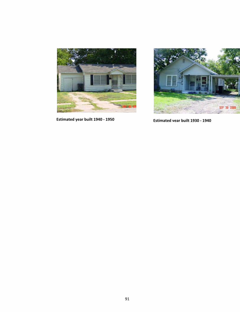
91
Estimated year built 1940 ‐ 1950 Estimated year built 1930 ‐ 1940

92
BASIC SPECIFICATIONS AND CONSTRUCTION DIAGRAMS OF A TYPICAL RESIDENTAL BUILDING
USE TYPE: 1-FAMILY DWELLING____________________________CLASS: 4 Average Quality. Mass produced one-family dwelling of average materials, design and workmanship. Meets or exceeds the minimum construction requirements of lending institutions and building codes. Average in appearance, some ornamentation on the front elevation. Framed, concrete block, tile, stone or brick exterior walls. Framed or masonry unit partition walls; wood framed ceilings; double wood or concrete slab floors; some special features, average plumbing installations. FOUNDATION:
a. Footings – Concrete or masonry. b. Walls – Concrete or masonry, or
stucco underpinning. c. Piers and Beams – Concrete,
masonry or some wood piers, 4 x 8 sills
FLOORS:
a. Structure – 2 x 8 joists 16” o.c. or concrete slab on fill.
b. Flooring –Hardwood, vinyl, tile, or carpet of average quality or concrete slab.
c. Subfloor – Average lumber or none d. Finish – Fill and varnish or average
covering.
EXTERIOR WALLS: a. Structure –2 x 4 wood studs 16”
o.c., good concrete block, tile, brick, or stone.
b. Outside Covering - Wood, plaster, asbestos, or masonry veneer on WF, or plaster, paint or none on masonry.
c. Sheathing – Solid of average lumber or none on masonry.
d. Insulation – None or 2” thick batts ROOF:
a. Structure – 2 x 4 or 2 x 6 rafters, 16” o.c. braced.
b. Roofing – Built up, wood asbestos or composition shingles.
c. Sheathing – Solid or strip of average lumber.
d. Insulation- None or insulation sheathing.
INTERIOR WALLS:
a. Structure – Single walls, 2 x 4 studs 16” o.c., or average masonry units.
b. Sheathing – Shiplap, sheetrock, paneling, tile or none on masonry
c. Finish – Textone, paint, paper, and natural finish
d. Insulation – None CEILINGS:
a. Structure 2 x 4 or 2 x 6 joists 16” o.c.
b. Sheathing – Shiplap, sheetrock, plaster or celotex tile.
c. Finish – Textone, paint or paper.d. Insulation – Full thick
MILLWORK:
a. Windows – Wood or metal single or double hung, metal casements, or jalousies
b. Doors – Good panel or slab of softwood or inexpensive hardwood.
c. Trim – Good molded softwood d. Built-ins – Mill made of softwood
or inexpensive hardwood.
ELECTRICAL: a. Wiring – Romax or conduit b. Switches and Outlets – Ample
with few special.

93
Estimated year built 1980 ‐ 1990 Estimated year built 1930 ‐ 1940
Estimated year built 1920 ‐ 1930 Estimated year built 1930 ‐ 1940's
Estimated year built 1990 ‐ 2000 Estimated year built 2000 ‐ 2004
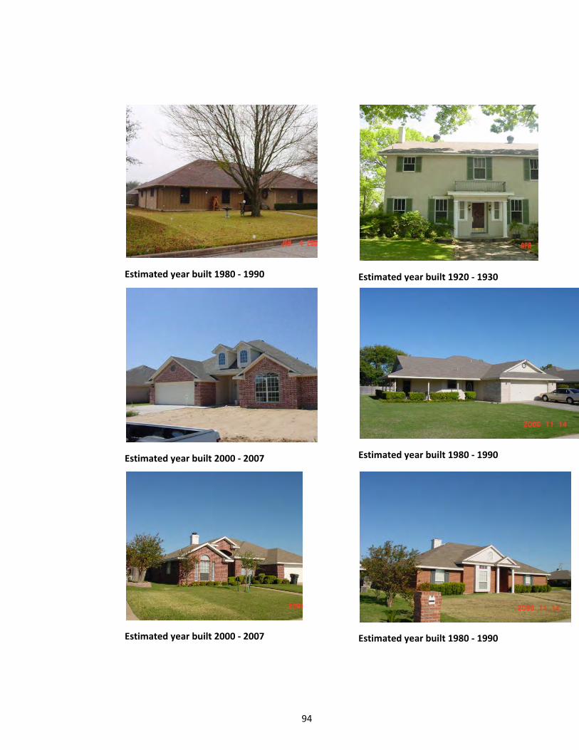
94
Estimated year built 1980 ‐ 1990 Estimated year built 1920 ‐ 1930
Estimated year built 2000 ‐ 2007 Estimated year built 1980 ‐ 1990
Estimated year built 2000 ‐ 2007
Estimated year built 1980 ‐ 1990

95
Estimated year built 1980 ‐ 1990 Estimated year built 1960 ‐ 1969
Estimated year built 1960 ‐ 1970 Estimated year built 2000 ‐ 2008
Estimated year built 2000 ‐ 2008 Estimated year built 1980 ‐ 1990

96
Estimated year built 2000 ‐ 2007 Estimated year built 2000 ‐ 2007
Estimated year built 1950 ‐ 1960 Estimated year built 2000 ‐ 2007
Estimated year built 1920 ‐ 1930
Estimated year built 1930 ‐ 1940

97
Estimated year built 2000 ‐ 2007 Estimated year built 2000 ‐ 2007
Estimated year built 1990 ‐ 2000
Estimated year built 1990 ‐ 2000
Estimated year built 2000 ‐ 2007
Estimated year built 1920 ‐ 1930

98
Estimated year built 1900 ‐ 1910 Estimated year built 2000 ‐ 2007
Estimated year built 1950 ‐ 1959

99
BASIC SPECIFICATIONS AND CONSTRUCTION DIAGRAMS OF A TYPICAL RESIDENTAL BUILDING
USE TYPE: 1-FAMILY DWELLING____________________________CLASS: 5 Good Quality. One-family dwelling of good material, design, and workmanship. May be mass produced in above average residential developments or built for an individual owner. Good in appearance. Framed, solid brick or stone, or veneer with backup of masonry units in exterior walls. Framed or masonry unit partition walls, wood framed ceilings; good double floors or screeded wood floors on concrete slab; average special features; good plumbing installations.
FOUNDATION a. Footings – Concrete or masonry b. Walls – Concrete or Masonry or stucco
underpinning c. Piers and Beams – Concrete or masonry piers, concrete or wood beams.
FLOORS
a. Structure – 2 x 8 or 2 x 10 joists 16” o.c., concrete slab – supported or floating.
b. Flooring – Hardwood, vinyl, tile, carpet or masonry.
c. Subfloor – Good lumber, well nailed or lumber on screeds
d. Finish – Fill and varnish or good covering.
EXTERIOR WALLS
a. Structure – 2 x 4 studs 16” o.c. with blocking, solid brick or stone or veneer on concrete block or tile.
b. Outside Covering – Good wood, asbestos, plaster, or masonry veneer.
c. Sheathing – Solid of good lumber or insulation sheathing or none on masonry.
d. Insulation – Batts or full thick or none on masonry.
ROOF
a. Structure – 2 x 6 rafters 16” o.c. well braced with purlins.
b. Roofing – Built-up, wood, asbestos, or composition shingles, or tile
c. Sheathing – Solid or strip of good lumber.
d. Insulation – Insulation sheathing.
INTERIOR WALLS
a. Structure – 2 x 4 studs 16” o.c. and blocking or brick, stone, tile or concrete block.
b. Sheathing – Sheetrock, paneling, lath and plaster, and tile or none on masonry.
c. Finish – Textone, paint, paper or natural finish or exposed on masonry.
d. Insulation – limited amount or none on masonry.
CEILINGS
a. Structure – 2 x 6 joists 16” o.c., some exposed beams
b. Sheathing – Sheetrock, finished wood, celotex and acoustical tile, or plaster
c. Finish – Textone, paint, paper or natural.
d. Insulation – Full thick MILLWORK
a. Windows – Good wood or metal awning, sliding glass, and special.
b. Doors – Good panel or slab of hardwood, sliding glass, and special
c. Trim – Molded softwood and hardwood and some special.
d. Built-Ins – Cabinets, cases, and bars of hardwood and good finish.
ELECTRICAL a. Wiring – Romax or conduit b. Switches and Outlets – Ample with
some special

100
Estimated year built 2000 ‐ 2008 Estimated year built 2000 ‐ 2008
Estimated year built 1885 ‐ 1920 Estimated year built 2000 ‐ 2004
Estimated year built 2000 ‐ 2004 Estimated year built 1920 ‐ 1930
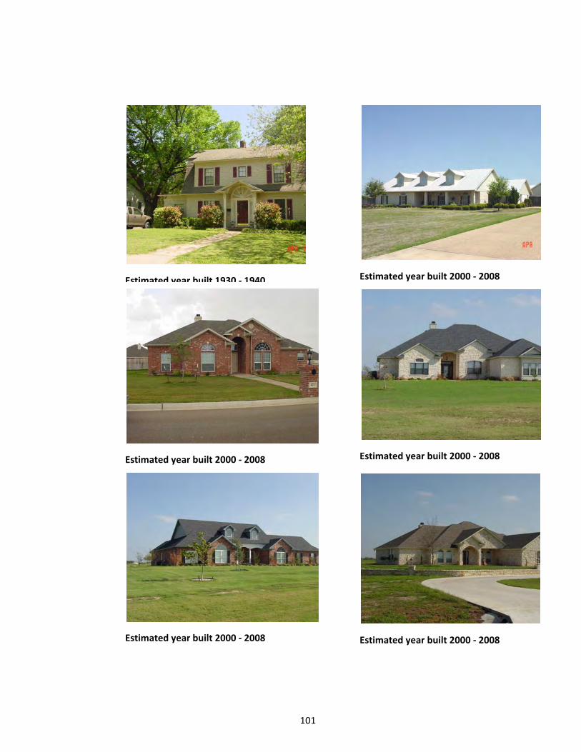
101
Estimated year built 1930 ‐ 1940 Estimated year built 2000 ‐ 2008
Estimated year built 2000 ‐ 2008 Estimated year built 2000 ‐ 2008
Estimated year built 2000 ‐ 2008 Estimated year built 2000 ‐ 2008

102
Estimated year built 2000 ‐ 2008 Estimated year built 1920 ‐ 1930
Estimated year built 1920 ‐ 1929
Estimated year built 1950 ‐ 1959
Estimated year built 1990 ‐ 1999 Estimated year built 1920 ‐ 1930

103
Estimated year built 1970 ‐ 1979 Estimated year built 2000 ‐ 2008
Estimated year built 2000 ‐ 2008 Estimated year built 1920 ‐ 1930
Estimated year built 1910 ‐ 1920 Estimated year built 1980 ‐ 1990
Estimated year built 1910 ‐ 1920 Estimated year built 2000 ‐ 2008
Estimated year built 2000 ‐ 2008
Estimated year built 2000 ‐ 2008
Estimated year built 2000 ‐ 2008 Estimated year built 2000 ‐ 2008

104
BASIC SPECIFICATIONS AND CONSTRUCTION DIAGRAMS OF A TYPICAL RESIDENTAL BUILDING
USE TYPE: 1-FAMILY DWELLING____________________________CLASS: 6 Very Good Quality. One-Family dwelling of very good materials and workmanship. Typically built in high quality tracts or developments and are frequently individually and professionally designed. Attractive in appearance. Framed or solid masonry exterior walls of good brick or stone, or good veneer on masonry back up. Framed, well braced or good masonry unit partition walls; wood framed, well braced ceilings; double wood floors of very good quality or screed double wood floors on concrete slab; average to many special features; very good plumbing installations. FOUNDATION
a. Footings – Reinforced concrete or masonry
b. Walls – Concrete or masonry or stucco underpinning
c. Piers and Beams – Concrete or masonry piers; concrete or wood beams
FLOORS
a. Structure – 2 x 10 joists 16” o.c. or concrete slab.
b. Flooring – Good hardwood, carpet, vinyl, or tile
c. Subfloor – Good lumber and sanded d. Finish – Lacquer or varnish or good
covering. EXTERIOR WALLS
a. Structure – 2 x 4 studs 16” o.c., well braced, solid brick or stone or veneer on good quality masonry.
b. Outside Covering – Select wood or masonry veneer or brick or stone on masonry.
c. Sheathing – Solid of good lumber or insulation sheathing or none on masonry.
d. Insulation – Full thick, cells filled with insulation on masonry units
ROOF
a. Structure – 2 x 6 rafters 16” o.c., well braced with purlins
b. Roofing – Built-up, wood, asbestos, or tile shingles
c. Sheathing – Solid of good lumber d. Insulation – Insulation sheathing or
batts
INTERIOR WALLS a. Structure – 2 x 4 studs 16” o.c. with
blocking and bracing or brick, stone, tile, or concrete block on masonry.
b. Sheathing – Sheetrock, paneling, plaster or tile
c. Finish – Textone, paint, paper natural finish, tile, plaster or paneling.
d. Insulation – May have batts or blown
CEILINGS
a. Structure – 2 x 6 or 2 x 8 joists 16” o.c. and exposed beams.
b. Sheathing – Sheetrock, paneling, plaster, solid wood or acoustical tiles.
c. Finish – Textone, paint, natural finish or good paper.
d. Insulation – Full thick with seal back MILLWORK
a. Windows – Metal or wood quality units with some special
b. Doors – Quality panel and slab of hardwood with some special
c. Trim – Molded softwood and hardwood with some special
d. Built-Ins – Cabinets, cases, and bars of select wood and superior finish
ELECTRICAL
a. Wiring – Romax and conduit b. Switches and Outlets – Ample and
Special
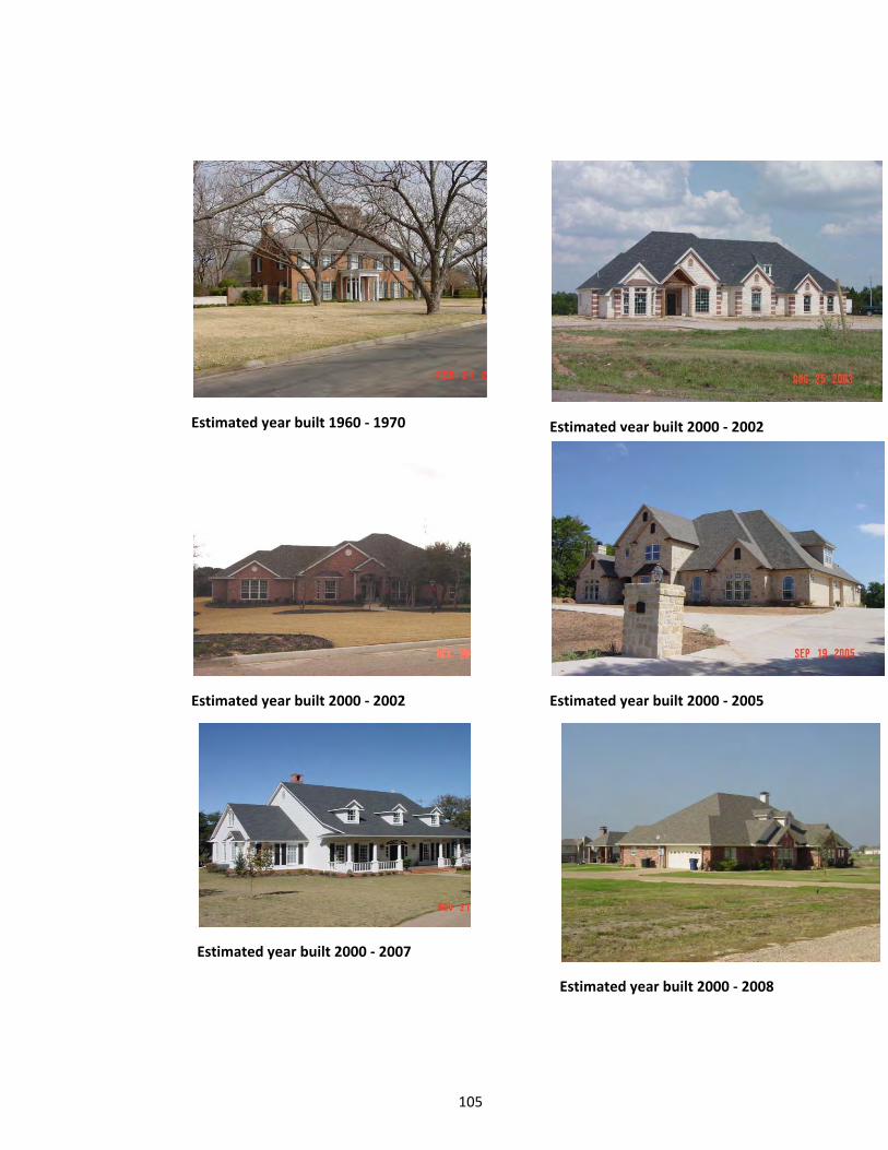
105
Estimated year built 1960 ‐ 1970 Estimated year built 2000 ‐ 2002
Estimated year built 2000 ‐ 2002 Estimated year built 2000 ‐ 2005
Estimated year built 2000 ‐ 2008
Estimated year built 2000 ‐ 2007

106
Estimated year built 2000 ‐ 2008 Estimated year built 1960 ‐ 1970
Estimated year built 1900 ‐ 1910
Estimated year built 1960 ‐ 1970
Estimated year built 2000 ‐ 2007 Estimated year built 1920 ‐ 1930

107
Estimated year built 1920 ‐ 1930 Estimated year built 1920 ‐ 1930
Estimated year built 1920 ‐ 1930 Estimated year built 2000 ‐ 2007
Estimated year built 1920 ‐ 1930 Estimated year built 1960 ‐ 1969

108
Estimated year built 1930 1939 Estimated year built 1920 ‐ 1930
Estimated year built 1880 ‐ 1910 Estimated year built 1990 ‐ 2000
Estimated year built 2000 ‐ 2004

109
BASIC SPECIFICATIONS AND CONSTRUCTION DIAGRAMS OF A TYPICAL RESIDENTAL BUILDING
USE TYPE: 1-FAMILY DWELLING____________________________CLASS: 7 Excellent Quality. One-family dwelling of very good materials and high quality workmanship, individually and professionally designed with considerable attention to detail. Very attractive in appearance. Heavy wood framed, solid brick or stone, or expensive masonry veneer with back up of very good masonry units in exterior walls. Heavy wood framed or good masonry unit interior walls; heavy framed, well braced ceiling; many special features of high-quality material and workmanship; many special plumbing features. FOUNDATION
a. Footings – Reinforced concrete or heavy masonry.
b. Walls – Concrete, solid masonry, or masonry veneer.
c. Piers and Beams – Concrete or masonry piers, concrete or wood beams
FLOORS
a. Structure – Steel joists, 2 x 10 or 2 x 12 wood joists, or concrete slab
b. Flooring – Select hardwood, expensive carpets and tiles
c. Subfloor – Tongue and groove and sanded
d. Finish – Hard lacquer or varnish and expensive coverings.
EXTERIOR WALLS
a. Structure – 2 x 4 and 2 x 6 studs 16” o.c. with blocking, solid brick or stone
b. Outside Covering – Select wood siding or masonry veneer, or brick or stone on masonry.
c. Sheathing – Solid of tongue and groove lumber or none on masonry.
d. Insulation – Full thick with seal back, cells filled with insulation on masonry.
ROOF
a. Structure – 2 x 6 and 2 x 8 rafters 16” o.c. braced with purlins.
b. Roofing – Built-up, wood or asbestos shingles, metal, or tile
c. Sheathing – Solid of tongue and groove lumber.
d. Insulation – Insulation sheathing or batts
INTERIOR WALLS a. Structure – 2 x 4 or 2 x 6 studs 16”
o.c. with blocking, or brick, stone, or tile on masonry.
b. Sheathing – Plaster, paneling or special walls
c. Finish – Paint, natural finish, expensive paper, or texture finish.
d. Insulation – Batts or blown or none on masonry.
CEILINGS
a. Structure – 2 x 6 or 2 x 8 joists 16” o.c. with exposed beams
b. Sheathing – Plaster, finished solid wood or acoustical tile.
c. Finish – Paint, textured finish or expensive paper
d. Insulation – Full thick with seal back MILLWORK
a. Windows – Metal and wood quality windows, sliding units, and special
b. Doors – Raised panel, solid slab, and special units.
c. Trim – Ornate molded hardwood and special trim.
d. Built-Ins – Special custom built cabinets and multiple special details
ELECTRICAL
a. Wiring – Heavy wire Romax or conduit
b. Switches and Outlets – Numerous and special

110
Estimated year built 1990 ‐ 2000 Estimated year built 1990 ‐ 2000
Estimated year built 2000 ‐ 2002
Estimated year built 2000 ‐ 2004
Estimated year built 2000 ‐ 2004
Estimated year built 1990 ‐ 1999

111
Estimated year built 1990 ‐ 2000 2 Estimated year built 1990 ‐ 2000 1
Estimated year built 2000 ‐ 2002 1
Estimated year built 2000 ‐ 2004 2
Estimated year built 2000 ‐ 2004 1
Estimated year built 1990 ‐ 1999 1
Estimated year built 2000 ‐ 2004 Estimated year built 1920 ‐ 1930
Estimated year built 1910 ‐ 1920
Estimated year built 2000 ‐ 2007
Estimated year built 2000 ‐ 2007 Estimated year built 2000 ‐ 2007

112
Estimated year built 2000 ‐ 2007 Estimated year built 2000 ‐ 2007
Estimated year built 2000 ‐ 2007 Estimated year built 2000 ‐ 2007
Estimated year built 2000 ‐ 2007 Estimated year built 2000 ‐ 2007

113
BASIC SPECIFICATIONS AND CONSTRUCTION DIAGRAMS OF A TYPICAL RESIDENTAL BUILDING
USE TYPE: 1-FAMILY DWELLING____________________________CLASS: 8 Mansion quality. Extremely expensive one-family dwelling of excellent, highest cost materials and workmanship, unique and professionally designed with considerable attention to detail. Distinctive and imposing in appearance. Heavy wood framed solid brick or stone, or expensive masonry veneer with back up of very good masonry units in exterior walls. Excellent, heavy and substantial interior walls, ceiling and floors; many ornamental and special features throughout; luxurious and numerous plumbing installations.
FOUNDATION a. Footings – Reinforced concrete or
heavy masonry. b. Walls – Concrete, solid masonry, or
masonry veneer. c. Piers and Beams – Reinforced
concrete, masonry, or steel. FLOORS
a. Structure – Steel joists, 2 x 10 or 2 x 12 wood joists, or concrete slab
b. Flooring – Parquet hardwood, carpets, terrazzo, and tiles
c. Subfloor – Tongue and groove and sanded
d. Finish – Hard lacquer or varnish and expensive coverings.
EXTERIOR WALLS
a. Structure – 2 x 6 and 2 x 8 studs 16” o.c. with blocking, solid brick or stone
b. Outside Covering – Select wood siding or masonry veneer, or brick or stone on masonry.
c. Sheathing – Solid of tongue and groove lumber or none on masonry.
d. Insulation – Full thick with seal back, cells filled with insulation on masonry.
ROOF
a. Structure – 2 x 8 and 2 x 10 rafters or wood trusses well braced.
b. Roofing – Built-up, wood or asbestos or slate shingles, metal, or tile
c. Sheathing – Solid of tongue and groove lumber.
d. Insulation – Full thick with seal back INTERIOR WALLS
a. Structure – 2 x 6 or 2 x 8 studs 16” o.c. with blocking, or brick, stone, or tile on masonry.
b. Sheathing – Plaster, paneling or special walls
c. Finish – Paint, natural finish, expensive paper, or texture finish.
d. Insulation – Batts or blown or cavity filled on masonry.
CEILINGS
a. Structure – 2 x 8 or 2 x 10 joists or wood trusses well braced, exposed beams
b. Sheathing – Plaster, finished solid wood or acoustical tile.
c. Finish – Paint, textured finish or expensive paper
d. Insulation – Full thick with seal back MILLWORK
a. Windows - Special metal, wood, or all glass units
b. Doors - Heavy panel or solid slab of hardwood, or special custom built
c. Trim – Heavy mold of hardwood and special trim.
d. Built-Ins – Special custom built of wood, metal, glass and fiber
ELECTRICAL
a. Wiring – Heavy wire Romax or conduit
b. Switches and Outlets – Numerous and special

114
Estimated year built 2000 ‐ 2005 Estimated year built 1950 1959 2
Estimated year built 2000 ‐ 2004
Estimated year built 1950 ‐ 1960
Estimated year built 2000 ‐ 2007
Estimated year built 2000 ‐ 2004 Estimated year built 2000 ‐ 2007
Estimated year built 2000 ‐ 2007
Estimated year built 2000 ‐ 2005

115
III. ANNEXES
A. ANNEX 1‐ GUIDE FOR RESIDENTIAL‐‐‐‐PICTOMETRY
1) LAST APP YR: NEXT TAX YEAR 2) LAST APPR: APPR NAME 3) LAST INSP DATE: DATE WORKED 4) REMARKS: PICTYYYY DATE WORKED (APP
INITIALS) 5) CK UTILITIES: FILL IN 6) PAC ACCT: CK GIS FOR CHG SINCE PREVIOUS FLYOVER 7) PICT ACCT: CK CHG SINCE 10 TO 13‐‐‐ALSO CK MEASUREMENTS AND PLACEMENT OF IMPS‐‐
‐DRAWINGS MUST MATCH PLACEMENT ON THE GROUND‐‐‐‐‐‐ALL BARNS, WKSHP, MB, SHEDS ETC ARE TO BE ON SEPARATE SEG FROM HOUSE !!! WITH CORRECT YB AND EY AND FEATURES
8) CK AND FILL IN FEATURES ON THE HOUSE‐‐‐‐‐LAMINATED SHEET‐‐‐‐ONES CIRCLED 9) PLEASE CODE BARN, METAL BUILDING, WORKSHOPS, SHEDS ETC CORRECTLY (DO NOT
LEAVE ON SP EXCP OR FLAT VALUED!!) a) 4 SIDED‐‐‐402 BARNS 460 METAL BUILDING 461 WORKSHOP b) 3 SIDED‐‐‐440 SHED. c) 1 OR 2 SIDED‐‐‐LEANTO‐‐‐‐‐IF BY ITSELF CODE 440 B FBL/CO (EXAMPLE) d) LEANTOS ARE TO BE CODED LIKE THE BUILDING THEY ARE ATTACHED TO. IF ATTACHED
TO A 460 THEN THE LEANTO STARTS WITH 460 B FBL/CO (EXAMPLE)‐‐‐THIS WAY WE CAN TELL WHICH OUT BUILDING IT IS ATTACHED TO WITHOUT LOOKING AT THE DRAWING‐‐‐IT SHOULD ALSO FOLLOW THE BUILDING IT IS ATTACHED TO.
e) EACH BUILDING WITH METHOD "B" MUST HAVE FEATURES i) 06‐‐WALL HEIGHT ii) 09‐‐‐FLOORING iii) 11‐‐‐PLUMBING iv) 12‐‐‐ELECTRIC v) 15‐‐‐NUMBER OF WALLS
f) TANKS ‐FARM STORAGE‐STEEL GRAIN BINS i) 450 R AG1 W/O DRYER
(1) FORMULA: DIA X DIA X .6YLL X HEIGHT = AREA (2) WRITE UP: WIDTH = HEIGHT = PERM =0 AREA = (3) NO DRAWING REQUIRED
ii) 450 R AG2 W/ DRYER (1) SAME AS ABOVE
g) CONTAINERS i) 440 B FB5/D+ 2000‐2001 SKETCH ii) FEATURES
(1) 06‐‐‐‐WALL HEIGHT (2) 15‐‐‐‐WALL COUNT
10) 432 MASONRY WALL‐‐‐‐TAKE THESE OFF ‐‐‐‐DO NOT PICK UP ANY LONGER 11) FENCES
a) MEASURE WITH PICTOMETRY, FENCE MEASUREMENTS ARE DIVIDED BETWEEN PID’S IF FENCE IS ON THE BOUNDARY.
12) TERRACE

116
a) MEASURE TERRACE AREA AROUND POOLS‐‐‐THEN POOL‐‐‐SUBTRACT AND WRITE DOWN THE SQ FT OF THE AREA OF THE TERRACE‐‐‐NO SKETCH IS REQUIRED
b) ALL OTHER TERRACES WITHOUT POOLS REQUIRE SKETCHES 13) OUTDOOR KITCHEN
a) 466 R KE_100K ADD FACTOR: USE % OF $100,000 FOR VALUE TO DEPRECIATE ‐‐AREA 1 OVERRIDE
14) STORAGES a) DO NOT LEAVE ANY AS SP EXCP b) SEE LISTING ORDER OF IMPROVEMENT DETAIL
15) HOUSE FEATURES‐‐‐RESIDENTIAL FEATURES AND CODES a) ALL THE ONES CIRCLED ARE REQUIRED IF THE HOUSE HAS
16) LIST IN THE COMMENT FIELD THE CHANGES MADE FOR TAX YEAR: LIST, ADD, CHANGE, REMOVE, UPDATE EXISTING INFO
17) EXAMPLE: LIST 447X3 ,411, 011X2, 2012 US a) EXAMPLE: LIST 460, 440X2 2012 US b) EXAMPLE: RELIST 402 US
18) LAND SEGMENTS a) LOOK AT HOW LAND IS CLASSED‐‐‐LOOK AT PICTOMETRY b) IF PACS HAS ALL OR MOSTLY NATIVE PASTURE AND YOU SEE CLEARED AREAS THAT
MAY BE IMPROVED PASTURE ‐‐‐‐BAILING HAY‐‐‐OR DRY CROP‐‐‐‐‐‐ASK THE AG APPRAISER TO VERIFY.
19) TOWER SITE a) IF LAND HAS A TOWER ON IT PUT TWR BY GROUP CODE (UNDER GENERAL ON CARD)
EVERYONE MUST FOLLOW THIS GUIDE SHEET

117
B. ANNEX 2‐ RESIDENTIAL FEATURES AND CODES
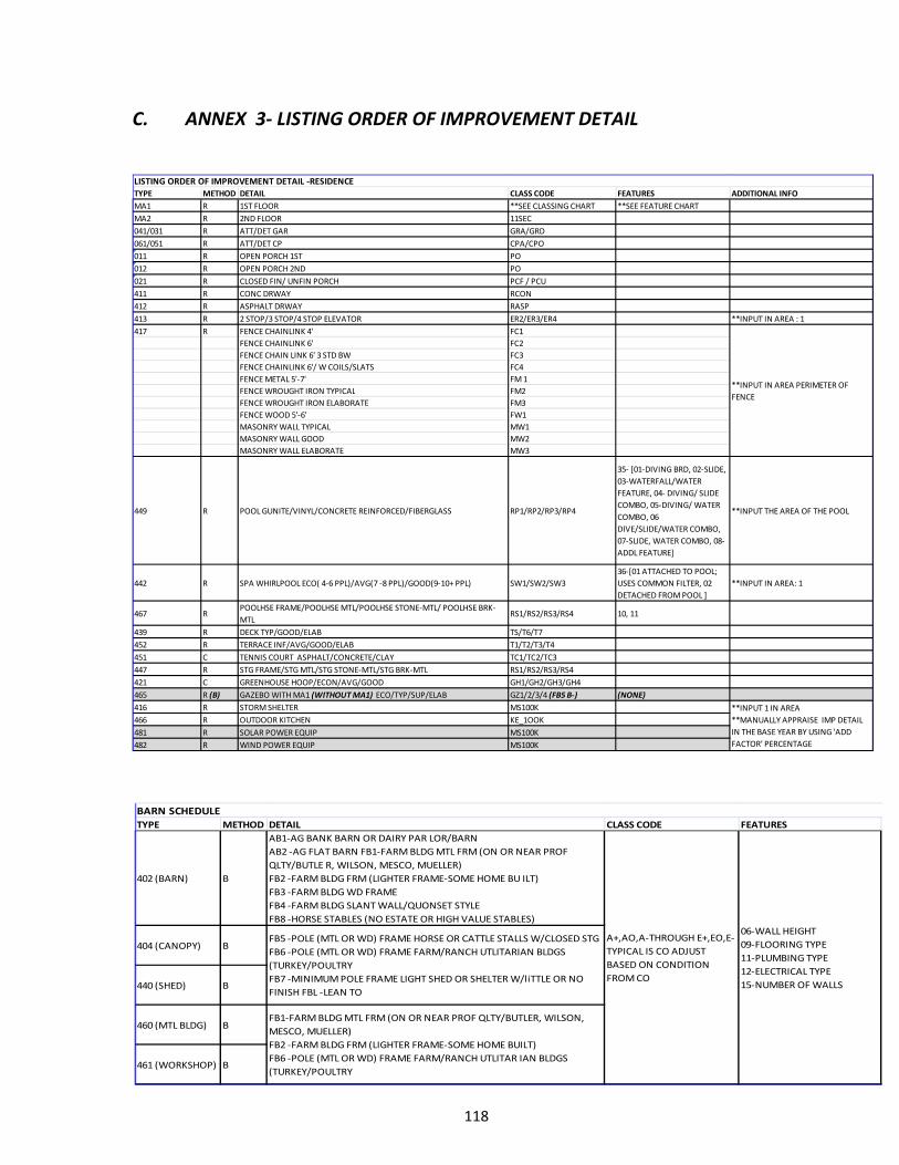
118
TYPE METHOD DETAIL CLASS CODE FEATURES
402 (BARN) B
AB1‐AG BANK BARN OR DAIRY PAR LOR/BARN
AB2 ‐AG FLAT BARN FB1‐FARM BLDG MTL FRM (ON OR NEAR PROF
QLTY/BUTLE R, WILSON, MESCO, MUELLER)
FB2 ‐FARM BLDG FRM (LIGHTER FRAME‐SOME HOME BU ILT)
FB3 ‐FARM BLDG WD FRAME
FB4 ‐FARM BLDG SLANT WALL/QUONSET STYLE
FB8 ‐HORSE STABLES (NO ESTATE OR HIGH VALUE STABLES)
404 (CANOPY) B
440 (SHED) B
460 (MTL BLDG) B
461 (WORKSHOP) B
BARN SCHEDULE
FB5 ‐POLE (MTL OR WD) FRAME HORSE OR CATTLE STALLS W/CLOSED STG
FB6 ‐POLE (MTL OR WD) FRAME FARM/RANCH UTLITARIAN BLDGS
(TURKEY/POULTRY
FB7 ‐MINIMUM POLE FRAME LIGHT SHED OR SHELTER W/liTTLE OR NO
FINISH FBL ‐LEAN TO
FB1‐FARM BLDG MTL FRM (ON OR NEAR PROF QLTY/BUTLER, WILSON,
MESCO, MUELLER)
FB2 ‐FARM BLDG FRM (LIGHTER FRAME‐SOME HOME BUILT)
FB6 ‐POLE (MTL OR WD) FRAME FARM/RANCH UTLITAR IAN BLDGS
(TURKEY/POULTRY
A+,AO,A‐THROUGH E+,EO,E‐
TYPICAL IS CO ADJUST
BASED ON CONDITION
FROM CO
06‐WALL HEIGHT
09‐FLOORING TYPE
11‐PLUMBING TYPE
12‐ELECTRICAL TYPE
15‐NUMBER OF WALLS
C. ANNEX 3‐ LISTING ORDER OF IMPROVEMENT DETAIL
TYPE METHOD DETAIL CLASS CODE FEATURES ADDITIONAL INFO
MA1 R 1ST FLOOR **SEE CLASSING CHART **SEE FEATURE CHART
MA2 R 2ND FLOOR 11SEC
041/031 R ATT/DET GAR GRA/GRD
061/051 R ATT/DET CP CPA/CPO
011 R OPEN PORCH 1ST PO
012 R OPEN PORCH 2ND PO
021 R CLOSED FIN/ UNFIN PORCH PCF / PCU
411 R CONC DRWAY RCON
412 R ASPHALT DRWAY RASP
413 R 2 STOP/3 STOP/4 STOP ELEVATOR ER2/ER3/ER4 **INPUT IN AREA : 1
417 R FENCE CHAINLINK 4' FC1
FENCE CHAINLINK 6' FC2
FENCE CHAIN LINK 6' 3 STD BW FC3
FENCE CHAINLINK 6'/ W COILS/SLATS FC4
FENCE METAL 5'‐7' FM 1
FENCE WROUGHT IRON TYPICAL FM2
FENCE WROUGHT IRON ELABORATE FM3
FENCE WOOD 5'‐6' FW1
MASONRY WALL TYPICAL MW1
MASONRY WALL GOOD MW2
MASONRY WALL ELABORATE MW3
449 R POOL GUNITE/VINYL/CONCRETE REINFORCED/FIBERGLASS RP1/RP2/RP3/RP4
35‐ [01‐DIVING BRD, 02‐SLIDE,
03‐WATERFALL/WATER
FEATURE, 04‐ DIVING/ SLIDE
COMBO, 05‐DIVING/ WATER
COMBO, 06
DIVE/SLIDE/WATER COMBO,
07‐SLIDE, WATER COMBO, 08‐
ADDL FEATURE]
**INPUT THE AREA OF THE POOL
442 R SPA WHIRLPOOL ECO( 4‐6 PPL)/AVG(7 ‐8 PPL)/GOOD(9‐10+ PPL) SW1/SW2/SW3
36‐[01 ATTACHED TO POOL;
USES COMMON FILTER, 02
DETACHED FROM POOL ]
**INPUT IN AREA: 1
467 RPOOLHSE FRAME/POOLHSE MTL/POOLHSE STONE‐MTL/ POOLHSE BRK‐
MTLRS1/RS2/RS3/RS4 10, 11
439 R DECK TYP/GOOD/ELAB TS/T6/T7
452 R TERRACE INF/AVG/GOOD/ELAB T1/T2/T3/T4
451 C TENNIS COURT ASPHALT/CONCRETE/CLAY TC1/TC2/TC3
447 R STG FRAME/STG MTL/STG STONE‐MTL/STG BRK‐MTL RS1/RS2/RS3/RS4
421 C GREENHOUSE HOOP/ECON/AVG/GOOD GH1/GH2/GH3/GH4
465 R (B) GAZEBO WITH MA1 (WITHOUT MA1) ECO/TYP/SUP/ELAB GZ1/2/3/4 (FB5 B‐) (NONE)
416 R STORM SHELTER MS100K
466 R OUTDOOR KITCHEN KE_1OOK
481 R SOLAR POWER EQUIP MS100K
482 R WIND POWER EQUIP MS100K
LISTING ORDER OF IMPROVEMENT DETAIL ‐RESIDENCE
**INPUT IN AREA PERIMETER OF
FENCE
**INPUT 1 IN AREA
**MANUALLY APPRAISE IMP DETAIL
IN THE BASE YEAR BY USING 'ADD
FACTOR' PERCENTAGE

119
REGULAR STYLE CARPORTS
General Information
12' x 21' - $695 18' x 21' - $795 20' x 21' - $995 22' x 21' - $1195 24' x 21' - $1295
12' x 26' - $895 18' x 26' - $995 20' x 26' - $1195 22' x 26' - $1495 24' x 26' - $1595
12' x 31' - $1095 18' x 31' - $1195 20' x 31' - $1495 22' x 31' - $1795 24' x 31' - $1995
12' x 36' - $1295 18' x 36' - $1395 20' x 36' - $1795 22' x 36' - $2095 24' x 36' - $2295
12' x 41' - $1495 18' x 41' - $1695 20' x 41' - $2095 22' x 41' - $2495 24' x 41' - $2695
Leg Height 21' Long 26' Long 31' Long 36' Long 41' Long
5' Tall Std. Std. Std. Std. Std.
6' Tall $50 $60 $75 $85 $100
7' Tall $100 $120 $150 $170 $200
8' Tall $150 $180 $225 $255 $300
9' Tall $200 $240 $300 $340 $400
10' Tall $250 $300 $375 $425 $500
11' Tall $300 $360 $450 $510 $600
12' Tall $350 $420 $525 $595 $700
Leg Height 21' Long 26' Long 31' Long 36' Long 41' Long
5' Tall $275 $345 $415 $485 $550
6' Tall $300 $375 $450 $525 $600
7' Tall $350 $435 $520 $605 $690
8' Tall $425 $520 $615 $710 $805
9' Tall $450 $555 $660 $765 $870
10' Tall $500 $620 $740 $860 $980
11' Tall $575 $710 $845 $980 $1,115
12' Tall $600 $750 $900 $1,050 $1,200
Leg Height 12' Wide 18' Wide 20' Wide 22' Wide 24' Wide
5' Tall $350 $420 $490 $560 $630
6' Tall $375 $450 $525 $600 $675
7' Tall $425 $505 $585 $665 $745
8' Tall $475 $560 $645 $730 $815
9' Tall $500 $590 $680 $770 $860
10' Tall $575 $680 $785 $890 $995
11' Tall $650 $770 $890 $1,010 $1,130
12' Tall $725 $860 $995 $1,130 $1,265
Roll Up Doors Windows Gable Ends
W X H 30" x 30" - $150 (Up To 24' Wide)
6' x 6' - $220 $150 Each
6' x 7' - $240
Vinyl Walk-In
Door
8' x 6' - $270
(Diamond Shaped
Window)
8' x 7' - $320 32" x 72" - $175
8' x 8' - $340 34" x 72" - $185
9' x 7' - $350 36" x 72" - $200
9' x 8' - $370 36" x 80" - $
10' x 8' - $400
10' x 10' - $450
Instructions: Measure length & width to determine base cost. Measure height from ground to the beginning of the
roof curve to determine additional side height cost from table. Add additional feature cost listed below if
applicable. Use "OTHER" depreciation to lower cost of carport to the determined amount.
Base Models Have Standard 5' Leg. Frame is 1' shorter than roof lengthwise. Not all structures meet codes.
Engineering is at additional cost. 29 Gauge Steel Roof, 2 1/2" 14 Gauge Galvanized Frame. Prices are for
top only.
Options: Side Height
Options: Both Sides Closed
Options: Each End Closed
Options: Extra's
Base Models
D. ANNEX 4‐ “PORTABLE” CARPORT VALUE GUIDE

120
E. ANNEX 5‐ RESIDENTIAL AND DUPLEX CLASS CODES

121
F. ANNEX 6‐ MANUFACTURED HOUSING CLASS CODES

122
G. ANNEX 8‐ BARN EFFECTIVE AGE GUIDE‐*Subject to Appraisers Discretion*
Yr Blt Eff Year Yr Blt Eff Year Yr Blt Eff Year Yr Blt Eff Year
2013 2013 1967 1991 1921 1981 1875 1980
2012 2013 1966 1991 1920 1981 1874 1980
2011 2013 1965 1990 1919 1981 1873 1980
2010 2012 1964 1990 1918 1981 1872 1980
2009 2012 1963 1990 1917 1980 1871 1980
2008 2012 1962 1989 1916 1980 1870 1980
2007 2012 1961 1989 1915 1980 1869 1980
2006 2010 1960 1989 1914 1980 1868 1980
2005 2008 1959 1988 1913 1980 1867 1980
2004 2008 1958 1988 1912 1980 1866 1980
2003 2006 1957 1988 1911 1980 1865 1980
2002 2006 1956 1988 1910 1980 1864 1980
2001 2005 1955 1987 1909 1980 1863 1980
2000 2003 1954 1987 1908 1980 1862 1980
1999 2003 1953 1987 1907 1980 1861 1980
1998 2003 1952 1987 1906 1980 1860 1980
1997 2001 1951 1987 1905 1980 1859 1980
1996 2001 1950 1986 1904 1980 1858 1980
1995 2000 1949 1986 1903 1980 1857 1980
1994 2000 1948 1986 1902 1980 1856 1980
1993 1999 1947 1986 1901 1980 1855 1980
1992 1999 1946 1986 1900 1980 1854 1980
1991 1998 1945 1986 1899 1980 1853 1980
1990 1998 1944 1986 1898 1980 1852 1980
1989 1997 1943 1985 1897 1980 1851 1980
1988 1997 1942 1985 1896 1980 1850 1980
1987 1997 1941 1985 1895 1980 1849 1980
1986 1996 1940 1984 1894 1980
1985 1996 1939 1984 1893 1980
1984 1996 1938 1984 1892 1980
1983 1996 1937 1984 1891 1980
1982 1996 1936 1984 1890 1980
1981 1996 1935 1984 1889 1980
1980 1995 1934 1983 1888 1980
1979 1995 1933 1983 1887 1980
1978 1995 1932 1983 1886 1980
1977 1994 1931 1983 1885 1980
1976 1994 1930 1983 1884 1980
1975 1994 1929 1983 1883 1980
1974 1992 1928 1982 1882 1980
1973 1992 1927 1982 1881 1980
1972 1992 1926 1982 1880 1980
1971 1991 1925 1982 1879 1980
1970 1991 1924 1982 1878 1980
1969 1991 1923 1982 1877 1980
1968 1991 1922 1981 1876 1980