2015 Broken Hill Resources Investment Symposium - Geology Survey of South Australia - Wolfgang...
28
Regional tectonic context of the Curnamona Province Anthony Reid and Wolfgang Preiss Geological Survey of South Australia
Transcript of 2015 Broken Hill Resources Investment Symposium - Geology Survey of South Australia - Wolfgang...
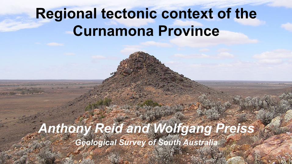
Regional tectonic context of the Curnamona Province
Anthony Reid and Wolfgang Preiss Geological Survey of South Australia

Pb-‐Ag-‐Zn deposit
Cu deposit / occurrence

Pb-‐Ag-‐Zn deposit
Cu deposit / occurrence
Olympic Cu-‐Au Province

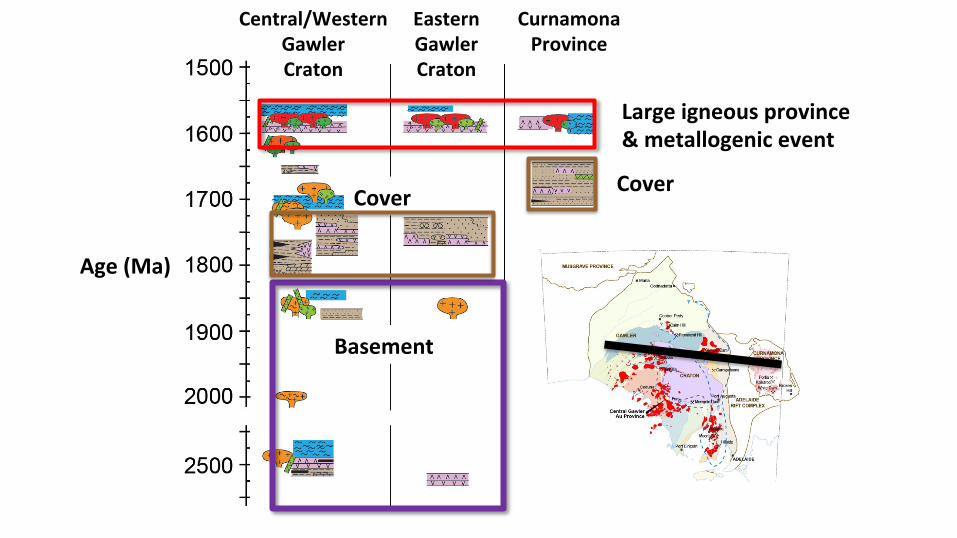
Age (Ma)
Central/Western Gawler Craton
Curnamona Province
Eastern Gawler Craton
Central/Western Gawler Craton
Curnamona Province
Eastern Gawler Craton
Basement
Cover
Large igneous province & metallogenic event
Cover
Age (Ma)

Central/Western Gawler Craton
Curnamona Province
Eastern Gawler Craton
Basement
Cover Cover
Age (Ma)
Large igneous province & metallogenic event
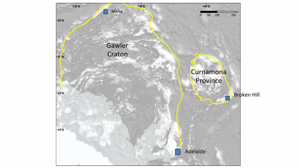
Gawler Craton
Curnamona Province
Adelaide
Broken Hill
Marla
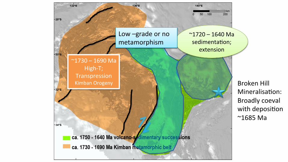
~1730 – 1690 Ma High-‐T;
Transpression Kimban Orogeny Broken Hill
MineralisaMon: Broadly coeval with deposiMon ~1685 Ma
~1720 – 1640 Ma sedimentaMon;
extension
Low –grade or no metamorphism
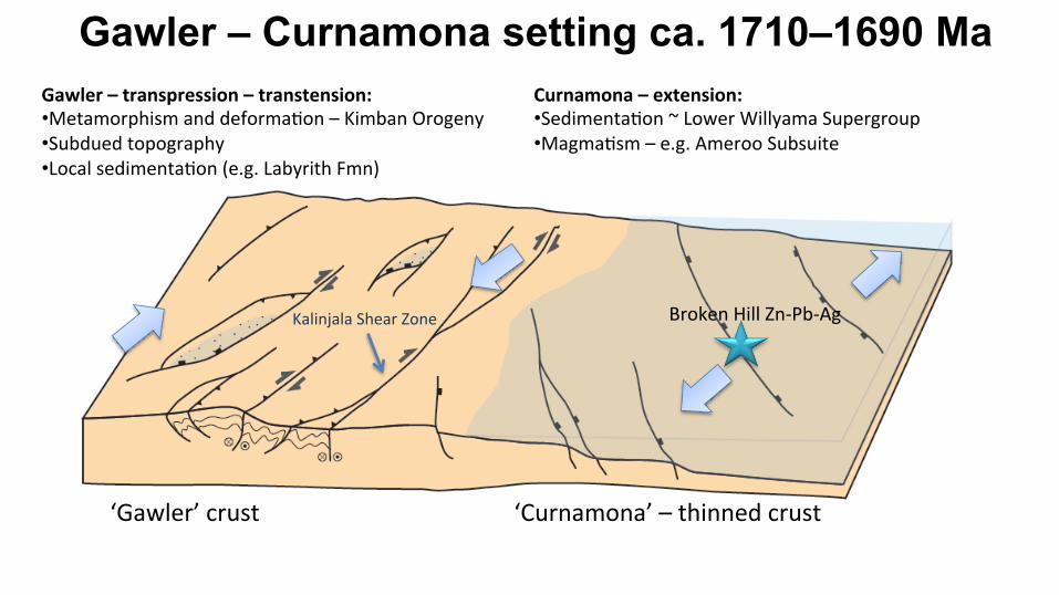
Gawler – Curnamona setting ca. 1710–1690 Ma Gawler – transpression – transtension: • Metamorphism and deformaMon – Kimban Orogeny • Subdued topography • Local sedimentaMon (e.g. Labyrith Fmn)
Curnamona – extension: • SedimentaMon ~ Lower Willyama Supergroup • MagmaMsm – e.g. Ameroo Subsuite
‘Gawler’ crust ‘Curnamona’ – thinned crust
Kalinjala Shear Zone Broken Hill Zn-‐Pb-‐Ag

ca. 1600 Ma Previously unmetamorphosed
Metamorhpic belt

1630 – 1590 Ma Olarian Orogeny:
Early HT-LP metamorphism & subsequent compression

1630 – 1590 Ma Olarian Orogeny:
Early HT-LP metamorphism & subsequent compression
Similar aged deformation and metamorphism in northern Gawler Craton
granulite
Decreasing metamorphic grade
UPPER CRUST

ca. 1590 Ma
Hiltaba Event:
magmatism,
hydrothermal fluid
flow, synchronous
with late Olarian
structures
BVS Hiltaba
Hiltaba

Hillside
PorMa; Kalkaroo
Moonta -‐ Wallaroo
Carrapateena
Olympic Dam
Prominent Hill
ca. 1590 Ma
Mineralisation
IOCG mineralisaHon: High fluid volume; relaHvely oxidised
Gold-‐dominated mineralisaHon: more reduced

The Curnamona Province is a small remnant of an originally continuous system of Late Palaeoproterozoic (1.75-1.64 Ga) sedimentary basins
and an ~1.6 Ga orogenic belt extending at least from north Queensland to Fleurieu Peninsula
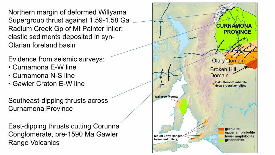
Evidence from seismic surveys: • Curnamona E-W line • Curnamona N-S line • Gawler Craton E-W line
East-dipping thrusts cutting Corunna Conglomerate, pre-1590 Ma Gawler Range Volcanics
Northern margin of deformed Willyama Supergroup thrust against 1.59-1.58 Ga Radium Creek Gp of Mt Painter Inlier: clastic sediments deposited in syn- Olarian foreland basin
CURNAMONA PROVINCE
Olary Domain Broken Hill Domain
Southeast-dipping thrusts across Curnamona Province
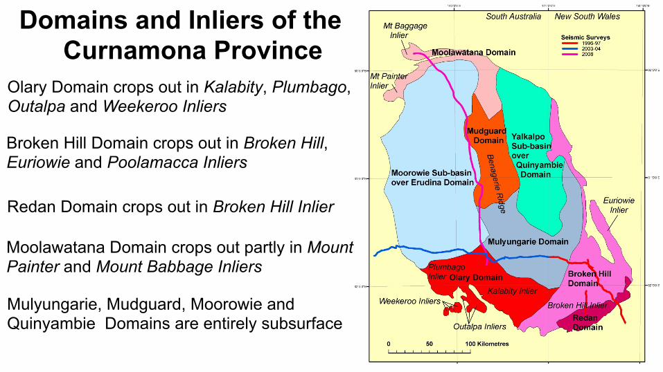
Domains and Inliers of the Curnamona Province
Olary Domain crops out in Kalabity, Plumbago, Outalpa and Weekeroo Inliers
Broken Hill Domain crops out in Broken Hill, Euriowie and Poolamacca Inliers
Redan Domain crops out in Broken Hill Inlier
Moolawatana Domain crops out partly in Mount Painter and Mount Babbage Inliers
Mulyungarie, Mudguard, Moorowie and Quinyambie Domains are entirely subsurface

Part of the original ‘Seamless Geology’ map (solid geology) of Curnamona Province in SA and NSW showing stratigraphic subdivision as envis- aged in the 1990s
Paragon Group Sundown Group Broken Hill Group Thackaringa Group Redan Gneiss

Total magnetic intensity of part of Olary Domain showing high and low TMI of Neoproterozoic rift corridors & complex magnetic pattern of Willyama Supergroup
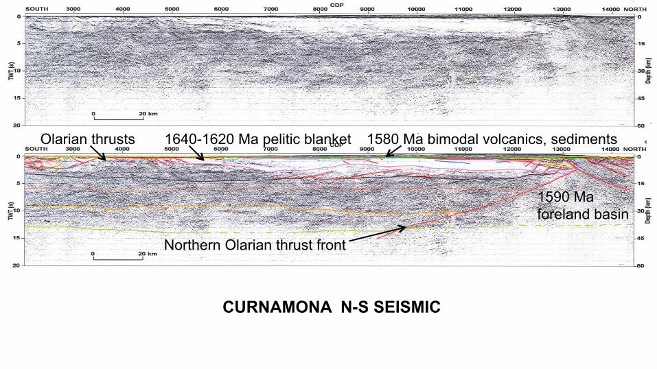
Olarian thrusts 1640-1620 Ma pelitic blanket 1580 Ma bimodal volcanics, sediments
1590 Ma foreland basin
Northern Olarian thrust front
CURNAMONA N-S SEISMIC
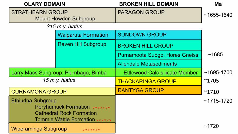
SUNDOWN GROUP BROKEN HILL GROUP
Larry Macs Subgroup: Plumbago, Bimba Ettlewood Calc-silicate Member
THACKARINGA GROUP
RANTYGA GROUP 15 m.y. hiatus
Purnamoota Subgp: Hores Gneiss
PARAGON GROUP
?15 m.y. hiatus
Allendale Metasediments
OLARY DOMAIN BROKEN HILL DOMAIN Ma
Walparuta Formation Raven Hill Subgroup
STRATHEARN GROUP Mount Howden Subgroup
~1655-1640
~1705
~1710 ~1715-1720
~1720
~1695-1700
CURNAMONA GROUP Ethiudna Subgroup
Peryhumuck Formation v v v v v v v
Cathedral Rock Formation Tommie Wattie Formation v v v v v v
Wiperaminga Subgroup v v v v v v v
~1685

+ + +
+
+
+
- - -
- -
+
-
+ Upright nappe limbs - Inverted nappe limbs
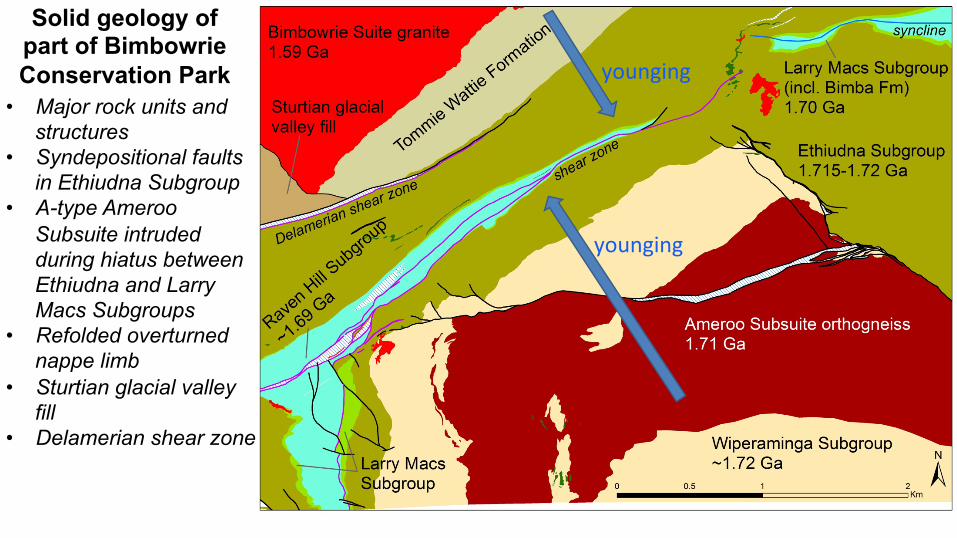
Solid geology of part of Bimbowrie Conservation Park
• Major rock units and structures
• Syndepositional faults in Ethiudna Subgroup
• A-type Ameroo Subsuite intruded during hiatus between Ethiudna and Larry Macs Subgroups
• Refolded overturned nappe limb
• Sturtian glacial valley fill
• Delamerian shear zone
younging
younging

• Early high-temperature metamorphism and migmatisation, perhaps under a thick insulating pelitic blanket
• Early continuous and progressive ductile deformation in mid-crust by isoclinal, recumbent folding and thrusting, resulting in gradual crustal thickening
• Early folds with sheath morphology to explain diverse fold axis orientations and apparent vergences; overall tectonic transport to NW
• Later folds tend to be more upright and thick-skinned, but formed within the same overall stress regime
• Granites result from mid-crustal melting of sediments, perhaps induced by a regional deep crustal or mantle event (‘Hiltaba Event’) at 1590 Ma
• Granites may be incidental to Olarian Orogeny
TECTONIC EVOLUTION OF OLARIAN OROGENY ~?1620–1590 MA OLARIAN OROGENY ?1.63 – 1.59 Ga
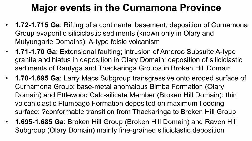
Major events in the Curnamona Province • 1.72-1.715 Ga: Rifting of a continental basement; deposition of Curnamona
Group evaporitic siliciclastic sediments (known only in Olary and Mulyungarie Domains); A-type felsic volcanism
• 1.71-1.70 Ga: Extensional faulting; intrusion of Ameroo Subsuite A-type granite and hiatus in deposition in Olary Domain; deposition of siliciclastic sediments of Rantyga and Thackaringa Groups in Broken Hill Domain
• 1.70-1.695 Ga: Larry Macs Subgroup transgressive onto eroded surface of Curnamona Group; base-metal anomalous Bimba Formation (Olary Domain) and Ettlewood Calc-silicate Member (Broken Hill Domain); thin volcaniclastic Plumbago Formation deposited on maximum flooding surface; ?conformable transition from Thackaringa to Broken Hill Group
• 1.695-1.685 Ga: Broken Hill Group (Broken Hill Domain) and Raven Hill Subgroup (Olary Domain) mainly fine-grained siliciclastic deposition

Major events in the Curnamona Province • 1.685 Ga: Mafic intrusives; submarine volcaniclastic Hores Gneiss and
formation of inhalative Broken Hill Pb-Zn-Ag orebody (Broken Hill Domain) • 1.685-1.67 Ga: Dominantly fine siliciclastic deposition of Sundown Group
in Broken Hill Domain; possible equivalents in Olary Domain • 1.67-1.655 Ga: Possible hiatus in deposition in both domains • 1.665-1.64 Ga: Dominantly fine siliciclastic deposition of Paragon Group
(Broken Hill Domain), Strathearn Group (Olary & Mulyungarie Domains) • 1.64-1.63 Ga: Speculative deposition of thick insulating pelitic blanket • 1.63-1.62 Ga: Earliest onset of Olarian metamorphism and migmatisation;
uncertain onset of Olarian deformation • 1.62-1.60 Ga: Olarian Orogeny possibly diachronous and propagating from
southeast to northwest; northwest-verging nappes, thrusts and sheath folds; low-angle foliations; possibly peak metamorphism from granulite in the southeast to greenschist in the north
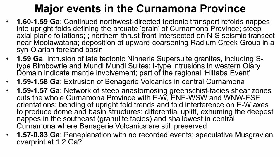
Major events in the Curnamona Province • 1.60-1.59 Ga: Continued northwest-directed tectonic transport refolds nappes
into upright folds defining the arcuate ‘grain’ of Curnamona Province; steep axial plane foliations; ; northern thrust front intersected on N-S seismic transect near Moolawatana; deposition of upward-coarsening Radium Creek Group in a syn-Olarian foreland basin
• 1.59 Ga: Intrusion of late tectonic Ninnerie Supersuite granites, including S-type Bimbowrie and Mundi Mundi Suites; I-type intrusions in western Olary Domain indicate mantle involvement; part of the regional ‘Hiltaba Event’
• 1.59-1.58 Ga: Extrusion of Benagerie Volcanics in central Curnamona • 1.59-1.57 Ga: Network of steep anastomosing greenschist-facies shear zones
cuts the whole Curnamona Province with E-W, ENE-WSW and WNW-ESE orientations; bending of upright fold trends and fold interference on E-W axes to produce dome and basin structures; differential uplift, exhuming the deepest nappes in the southeast (granulite facies) and shallowest in central Curnamona where Benagerie Volcanics are still preserved
• 1.57-0.83 Ga: Peneplanation with no recorded events; speculative Musgravian overprint at 1.2 Ga?
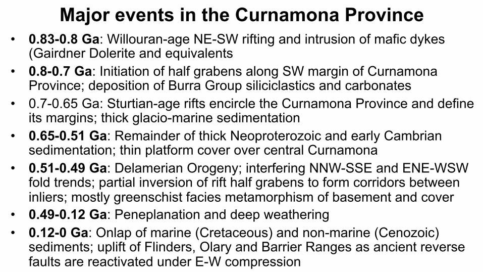
Major events in the Curnamona Province • 0.83-0.8 Ga: Willouran-age NE-SW rifting and intrusion of mafic dykes
(Gairdner Dolerite and equivalents • 0.8-0.7 Ga: Initiation of half grabens along SW margin of Curnamona
Province; deposition of Burra Group siliciclastics and carbonates • 0.7-0.65 Ga: Sturtian-age rifts encircle the Curnamona Province and define
its margins; thick glacio-marine sedimentation • 0.65-0.51 Ga: Remainder of thick Neoproterozoic and early Cambrian
sedimentation; thin platform cover over central Curnamona • 0.51-0.49 Ga: Delamerian Orogeny; interfering NNW-SSE and ENE-WSW
fold trends; partial inversion of rift half grabens to form corridors between inliers; mostly greenschist facies metamorphism of basement and cover
• 0.49-0.12 Ga: Peneplanation and deep weathering • 0.12-0 Ga: Onlap of marine (Cretaceous) and non-marine (Cenozoic)
sediments; uplift of Flinders, Olary and Barrier Ranges as ancient reverse faults are reactivated under E-W compression