2013 Minnesota Fire Weather Annual Operating Plan VII ... · PDF file2013 Minnesota Fire...
29
27 2013 Minnesota Fire Weather Annual Operating Plan VII. Appendix VII. APPENDICES (2013) A. Address and Phone Directory B. Glossary of Meteorological Terms C. Smoke Management D. Haines Index E. Zones, Counties, Cities, and Weather Stations F. NOAA Weather Radio Network G. Spot Forecast Request Form
Transcript of 2013 Minnesota Fire Weather Annual Operating Plan VII ... · PDF file2013 Minnesota Fire...

27
2013 Minnesota Fire Weather Annual Operating Plan
VII. Appendix
VII. APPENDICES (2013)
A. Address and Phone Directory
B. Glossary of Meteorological Terms
C. Smoke Management
D. Haines Index
E. Zones, Counties, Cities, and Weather Stations
F. NOAA Weather Radio Network
G. Spot Forecast Request Form

28
APPENDIX A:
ADDRESS AND PHONE DIRECTORY
NATIONAL WEATHER SERVICE - U.S. Department of Commerce
Minneapolis/Chanhassen, MN
National Weather Service
1733 Lake Drive West
Chanhassen, MN 55317-8581
http://weather.gov/mpx
Mike Griesinger, F/W Focal Point [email protected]
Dan Luna, MIC [email protected]
Duluth, MN National Weather Service
5027 Miller Trunk Highway
Duluth, MN 55811-1442
http://weather.gov/dlh
Amanda Graning, F/W Focal Point [email protected] Geoff Grochocinski, Asnt F/W Focal Point [email protected] Michael R. Stewart, MIC [email protected]
Grand Forks, ND
National Weather Service
4797 Technology Circle
Grand Forks, ND 58203-0600
http://weather.gov/fgf
Al Voelker, F/W Focal Point [email protected]
Brad Hopkins Assistant F/W Focal Point [email protected]
Mark Frazier, MIC [email protected]
La Crosse, WI
National Weather Service
N2788 County Road
La Crosse, WI 54601-3038
http://weather.gov/arx
Dave Schmidt, F/W Focal Point [email protected]
John Wetenkamp, Asnt F/W Focal Point [email protected]
Glenn Lussky, MIC [email protected]

29
Sioux Falls, SD
National Weather Service
26 Weather Lane
Sioux Falls, SD 57104-0198
http://weather.gov/fsd
Mike Fuhs, F/W Focal Point [email protected]
Jeff Chapman, backup [email protected]
Sally Pavlow Johnson, MIC [email protected]
Aberdeen, SD
National Weather Service
825 Brown County 14 S.
Aberdeen, SD 57401
http://weather.gov/abr
Travis Tarver, F/W Focal Point [email protected]
James Scarlett, MIC [email protected]
National Fire Weather Operations Coordinator Larry Van Bussum, Phone 208-334-9824, or 9862
National Interagency Fire Center (NIFC)
3833 South Development Avenue, Bldg 3807
Boise, ID 83705-5354 [email protected]
http://www.boi.noaa.gov/firewx.htm
NWS Regional Fire Weather Program Leader Jen Zeltwanger (Acting)
Central Region Headquarters [email protected] 7220 NW 101
st Terrace
Kansas City, MO 64153
Minnesota Interagency Fire Center (MIFC) 402 11th Street SE
Grand Rapids, Minnesota 55744
MIFC Dispatch (24 hours)……………………..218-327-4558
Tom Fasteland, MIFC Coordinator [email protected]
Phone 218-327-4583
Fax 218-327-4528

30
U.S. FOREST SERVICE - U.S. Department of Agriculture Chippewa National Forest
Route 3, Box 219
Cass Lake, MN 56633
218-335-8600
Superior & Chippewa National Forest Dispatch
(All dispatching for Chippewa NF is done through Superior Dispatch)
Phone 218-327-4175 (Day and Night)
Fax 218-327-4528
Mindy Lane, Forest Dispatcher [email protected]
Phone 218-327-4176
Doug Ottosen, USFS FMO [email protected]
Phone 218-327-4568
Brian Jenkins USFS FMO [email protected]
Phone 218-327-4571
Fax 218-327-4527
Fire Cache (Vacant)
Phone 218-327-4578
Eastern Area Interagency Coordination Center (EACC)
626 E. Wisconsin Avenue, Suite 500
Milwaukee, WI 53202
www.fs.fed.us/eacc
Laura McIntyre-Kelly, Center Manager [email protected]
Phone 414-944-3811
Fax 414-944-3838
Steve Marien, EACC Meteorologist [email protected]
Eastern Area Fire Weather Program Manager Phone: 651-290-3030 x 229
111 East Kellogg Blvd, Suite 105
St. Paul, MN 55101 Fax: 651-290-3815
Fire and Emergency Operations(vacant)
U S Forest Service, R9-RO, Attm AFM Phone 414-297-3682
310 W. Wisconsin Avenue, Suite 500 Fax 414-297-3642
Milwaukee, WI 53203-2200

NATIONAL PARK SERVICE - U.S. Department of the Interior
Gia Wagner, Biologist Phone 507-825-5464
Pipestone National Monument Fax 507-825-5466
36 Reservation Avenue [email protected]
Pipestone, Minnesota 56164-1269
Scott Bressler, FMO Phone 218-283-6658
Fire Management Officer Fax 218-285-7407
National Park Service [email protected]
Voyageurs National Park [email protected]
3131 Hwy 53
International Falls, MN 56649
U. S. FISH AND WILDLIFE SERVICE - U.S. Department of the Interior
Dan Dearborn, RFMC Phone 320-273-2247
U.S. Fish and Wildlife Service [email protected]
Big Stone Nat’l Wildlife Refuge
44843 County Road 19
Odessa, MN 56276
Russ Langford, RFMS Phone 612-713-5498
West Zone FMO
56 American Blvd. W Suite 990 Fax 612-713-5287
Bloomington, MN 55437 [email protected]
Charlie Blair, Refuge Manager [email protected]
Minnesota Valley NWR
Kris Larson, FMO Phone 320-693-2849 ext 117
Litchfield NWR [email protected]
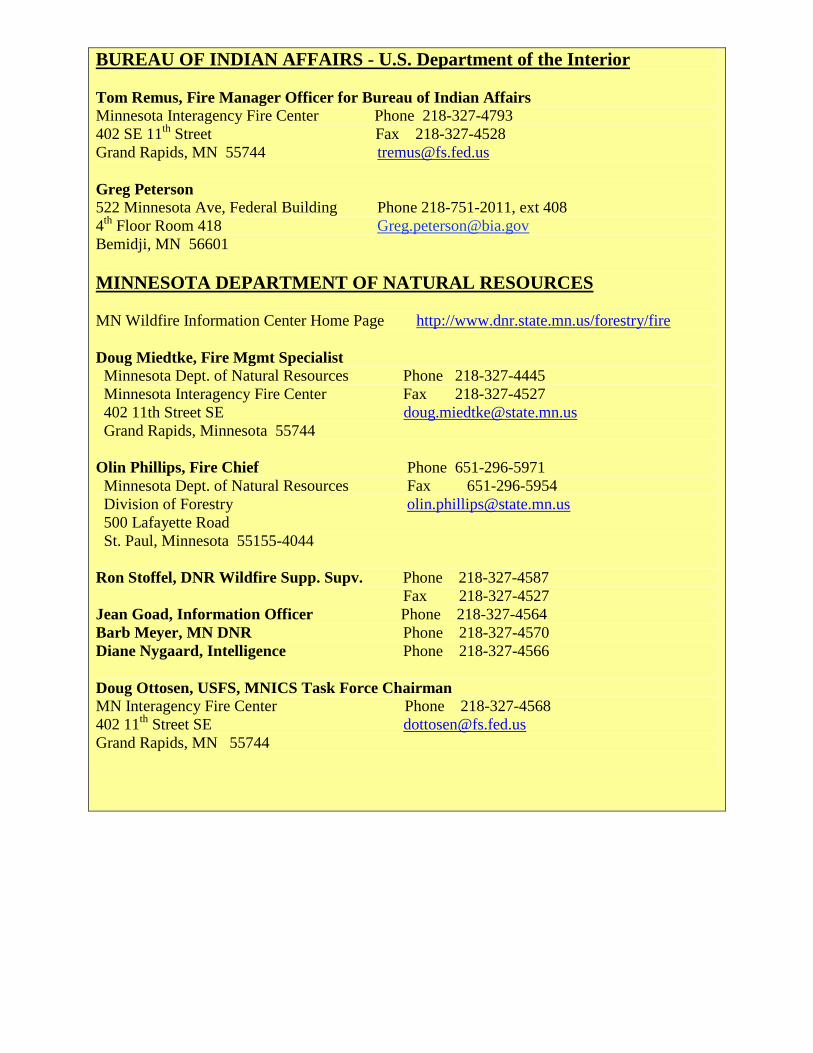
BUREAU OF INDIAN AFFAIRS - U.S. Department of the Interior
Tom Remus, Fire Manager Officer for Bureau of Indian Affairs
Minnesota Interagency Fire Center Phone 218-327-4793
402 SE 11th
Street Fax 218-327-4528
Grand Rapids, MN 55744 [email protected]
Greg Peterson
522 Minnesota Ave, Federal Building Phone 218-751-2011, ext 408
4th
Floor Room 418 [email protected]
Bemidji, MN 56601
MINNESOTA DEPARTMENT OF NATURAL RESOURCES
MN Wildfire Information Center Home Page http://www.dnr.state.mn.us/forestry/fire
Doug Miedtke, Fire Mgmt Specialist Minnesota Dept. of Natural Resources Phone 218-327-4445
Minnesota Interagency Fire Center Fax 218-327-4527
402 11th Street SE [email protected]
Grand Rapids, Minnesota 55744
Olin Phillips, Fire Chief Phone 651-296-5971
Minnesota Dept. of Natural Resources Fax 651-296-5954
Division of Forestry [email protected]
500 Lafayette Road
St. Paul, Minnesota 55155-4044
Ron Stoffel, DNR Wildfire Supp. Supv. Phone 218-327-4587
Fax 218-327-4527
Jean Goad, Information Officer Phone 218-327-4564
Barb Meyer, MN DNR Phone 218-327-4570
Diane Nygaard, Intelligence Phone 218-327-4566
Doug Ottosen, USFS, MNICS Task Force Chairman MN Interagency Fire Center Phone 218-327-4568
402 11th
Street SE [email protected]
Grand Rapids, MN 55744
APPENDIX B
Glossary of Meteorological Terms
A
ADDS - Automated Digital Data Service. An interactive web site at the NWS’s Aviation
Weather Center. Hourly surface maps are available which allow fire personnel to assess and
track wind shifts, temperature, and dew points in a region.
Adiabatic Process - A thermodynamic process in the atmosphere involving warming or cooling
of air normally when a parcel or layer of air moves up or down. Cooling of the air parcel occurs
as it moves up and expands. The parcel warms as it descends and as the surrounding air pressure
increases. The dry lapse rate of 5.5o F per 1000 feet of altitude describes how unsaturated air will
cool. The moist adiabatic lapse rate of 3.0 o F per 1000 feet describes a saturated air parcel
movement.
Advection - The horizontal movement of air or of a specific component of air. Warm air
advection or moisture advection that occurs may change the fire behavior.
AFD - Area Forecast Discussion. An unscheduled product from the NWS used to describe the
weather features and trends for a forecast period. Although somewhat technical, it does list the
features which the forecaster is following.
Air Mass - An extensive body of air having the same properties of temperature and moisture in
the horizontal plane.
Anemometer - An instrument for measuring wind speed.
Anticyclone - An area of high pressure with closed, clockwise circulation. Its common name is
simply a High. It is designated on a surface weather chart as a blue H.
Area Forecast Discussion (AFD) - See AFD
Atmospheric Pressure - The force exerted per unit area by the weight of the air above.
ASOS - Automated Surface Observing System - An automated weather system deployed at
airports nationwide. They provide hourly reports called METARs which are plotted on surface
weather maps.. These systems are primarily owned by the NWS and the Federal Aviation
Administration (FAA)...
ATMU – Atmospheric Theodolite Meteorological Unit – portable equipment used by NWS
Incident Meteorologists (IMET) to measure wind speed and direction aloft.
AWIPS -Advanced Weather Interactive Processing System- A powerful weather processing
workstation used by forecasters at NWS Weather Forecast Offices.
AWOS - Automated Weather Observing System An automated weather system deployed at
airports nationwide. They provide hourly reports called METARs which are plotted on surface
weather maps.. Most systems are owned by state agencies. They are similar to ASOSs.
B
Backing Winds - Winds that change direction in a counter-clockwise direction with altitude in
the vertical A south wind at the surface and an east wind at some point aloft would be an
example of backing winds.
Barometer - An instrument for measuring atmospheric pressure.
Boundary Layer - The layer of air far enough above the surface to be free of frictional
influences of the earth.
C

Chinook Wind - A foehn wind blowing down the eastern slopes of the Cascades, Rocky
Mountains, and over the adjacent plains in the United States and Canada. In winter, this warm,
dry wind causes snow to disappear with remarkable rapidity, and hence it has been nicknamed
the “snow eater”. In hot dry weather, Chinook winds can quickly extend fire weather conditions
to the ”extreme”.
Cirrus - A form of high cloud composed of ice crystals that do not obscure the sun to any great
degree. They normally have a fibrous or wispy appearance.
Cold Front: The leading edge of a relatively cold air mass that displaces warmer air. The
heavier cold air may cause some of the warm air to be lifted. If the lifted air contains enough
moisture, the result may be cloudiness, precipitation, and thunderstorms. If both air masses are
dry, no clouds may form. Following the passage of a cold front in the Northern Hemisphere,
westerly or northwesterly winds of 15 to 30 or more miles per hour often continue for 12 to 24
hours.
Condensation - The atmospheric process by which water vapor changes into liquid form. This
process releases heat.
Convection - As specialized in meteorology, atmospheric motions that are predominantly
upward in the absence of wind (which distinguishes this process from advection), resulting in
vertical mixing and transport of atmospheric properties. Convection is normally thought of as the
process which initiates cumulus clouds and thunderstorms by heating the air from below.
Convergence - Net horizontal flow of air into an area associated with low pressure systems. If
convergence occurs at the surface, upward vertical motion results. Consequently, areas of
convergent winds are regions favorable to formation of clouds and development of rain.
Coriolis Force - An apparent force due to the rotation of the earth that causes a deflection of air
to the right in the Northern Hemisphere as the air flows from high to low pressure. Aloft, the
force balances the pressure gradient force resulting in winds flowing parallel to the height lines
on an upper air chart.
Cumulonimbus - The ultimate growth of a cumulus cloud into an anvil shape, with considerable
vertical growth, usually fibrous ice crystal tops, and probably accompanied by lightning, thunder,
hail, and strong winds.
Cumulus - A principal, low cloud type in the form of individual cauliflower-like cells of sharp
nonfiberous outline and less vertical development than cumulonimbus.
Cyclone - An area of low atmospheric pressure that has closed counter clockwise circulation.
Cyclones usually bring about marked changes of weather and temperature during their passage.
Other name given to cyclones are “low” or “depression”.
D
Derecho - A downburst straight line wind event from a mesoscale convective systems that
produces widespread damage. The Boundary Waters Canoe Area blowdown of July 4, 1999 was
a derecho.
Dew Point - The temperature to which air must be cooled at constant pressure and moisture
content for saturation to occur.
Dispersion - The decrease in concentration of airborne pollutants as they spread throughout an
increasing volume of the atmosphere.
Dispersion Index - A numerical value computed by multiplying the transport wind times the
mixing depth or height of the mixing layer. Ranges of index values are assigned descriptive
terms indicating how well the atmosphere might function at spreading out or dispersing smoke.
In Minnesota and Wisconsin the following values are used in the narrative fire weather forecasts.
<13000……Poor; 13000 to 29000…...Fair; 30000 to 59000…...Good; >60000……Excellent

Diurnal - Daily, especially pertaining to cyclic actions that are completed within a 24 hour
period and which recur every 24 hours. The daily high and low temperature range is a diurnal
cycle.
Divergence - The condition that exists when the distribution of winds within a given volume
results in a net horizontal flow of air outward from the region. In divergence at lower levels, the
resulting deficit is compensated by a downward movement of air from aloft. Divergence in upper
levels of the atmosphere is often mentioned in Area Forecast Discussion products (AFD).
Divergence in the wind flow aloft produces a compensating area of convergence near the surface
resulting in the formation of low pressure centers or troughs. Divergence aloft can lead to the
development of precipitation.
Dry bulb - An ordinary thermometer used to determine the ambient or existing air temperature.
In a psychrometer both a dry bulb thermometer and a wet bulb thermometer are read in order to
determine the relative humidity.
Dry Lightning Storm - A thunderstorm that produces little if any precipitation. Often virga is
seen along with the lightning.
Drought Index: A number representing net effect of evaporation, transpiration, and precipitation
in producing cumulative moisture depletion in deep duff or upper soil layers.
E
El Nino - An abnormal warming of the eastern Pacific Ocean along the west coast of South
America. This pattern often disrupts normal weather cycle.
Evaporation - The transformation of a liquid into a gaseous state. Heat is lost by the liquid
during the process.
F
Fire Weather - Weather conditions that influence fire ignition, behavior and suppression.
Fire Weather Watch: A term used by fire weather forecasters to notify land management
agencies, usually 18 to 72 hours ahead of a situation where fire weather parameters would create
dangerous fire conditions.
Foehn Wind - Pronounced “Fern” A type of general wind that occurs when stable, high pressure
air is forced across and then down the lee slopes of a mountain range. The descending air is
warmed and dried due to adiabatic compression. In that process, wind flowing down hill warms
at the rate of 5.5o per 1,000 feet. Some local names for a foehn wind are: Santa Ana, Chinook, or
Mono.
Fog - A cloud at the earth’s surface. Fog consists of numerous droplets of water which
individually are so small that they cannot readily be distinguished by the naked eye. Three of the
most common types of fog are: advection fog, radiation fog, and upslope fog.
Free Air - That portion of the atmosphere that is not modified by local surface frictional affects.
Friction Layer - The layer of the atmosphere in which the frictional force of the earth’s surface
exercises an appreciable influence on winds. This is generally the air within about 1500 feet of
the ground.
Front - The transition zone between two air masses of different density and temperature. Fronts
emerge from a low pressure center. A cold front is the lead edge for colder and more dense air. A
warm front marks the northern or eastern edge of a warmer and less dense air mass. `
Frontal Inversion - An increase in temperature with height, normally near and ahead of an
advancing warm front. Warm, less dense air rides up and over the retreating colder air to the
north.

G
General Winds - Large scale winds caused by the pressure gradient between high and low
pressure systems but generally influenced and modified in the lower atmosphere by terrain.
GOES - Geostationary Operational Environmental Satellite. Weather satellites that remain at
a fixed location 22,500 miles above the earth. East GOES is at 75o W, and West GOES is at 135
o
W GOES satellites provide a variety of weather imagery but also handle uplink and downlink
communication with various observing technologies such as RAWS.
GPS Winds - Winds aloft measured by GPS navigation equipment in an aircraft.
Gradient - The change in a property between two locations. Pressure gradient is the difference
in air pressure between areas of high and low pressure.
Gradient Winds - winds that flow parallel to the contours on upper air charts. This usually
occurs above 1500 feet above ground level. Below that point winds cross the isobars at an angle.
Gust - A sudden, brief increase in the speed of the wind.
Gust Front - The leading edge of cold dense air flowing outward from a thunderstorm. The
boundary is marked by rising air above it and downward motion behind it. Winds can be quite
strong and gusty. Gust fronts are sometimes visible on Doppler radar as thin circular arcs around
a thunderstorm cell or complex.
H
Haines Index: An atmospheric index used to indicate the potential for wildfire growth by
measuring the stability and dryness of the air over a fire.
Hazardous Weather Outlook (HWO) - An alerting tool issued by the NWS at least every
morning by 730 a.m. The HWO briefly explains potential weather hazards in the seven days
ahead.
Heat Index - A discomfort index used to described the combined effects of temperature and
humidity on the body’s ability to cool itself.
High Clouds - Thin clouds, generally above 20,000 feet. The clouds are thin and wispy and
comprised of ice crystals. Clouds in this ground include: cirrus, cirrostratus, and cirrocumulus.
They are often indications of an approaching low pressure area, particularly a warm front.
High Pressure (Ridge) - An area on the surface map where atmospheric pressure measured by
barometers is higher than the surrounding air. High pressure results from air descending into a
region. On weather maps, highs are designated with a blue H and have closed isobars
surrounding them. High pressure ridges usually are areas of cooler, subsiding air associated with
quiet weather. Circulation around a high is in a clockwise direction. Over time, a subsidence
inversion often forms.
HPC - Hydrometeorological Prediction Center. A part of the National Center for Environmental
Prediction. The HPC is responsible for producing surface maps every three hours, forecast
surface maps for every six hours, and the quantitative precipitation forecast (QPF).
Hudson Bay High - High Pressure centered near Hudson Bay, Canada. The Hudson Bay High is
a contributor to fire weather problems. The air flowing clockwise around the high emerges from
a cold region. As it moves south and warms, the relative humidity falls significantly. The
resulting northeast winds that flow into Minnesota and Wisconsin are dry and can increase fire
behavior.
Humidity - The measure of water vapor content in the air.
I
Infrared (IR) - Radiation emitted from objects in the spectrum between visible light and
microwaves. Weather satellites detect levels of IR radiation and display the data in a manner
such that darker grey shades represent warm temperatures and whiter colors represent cooler
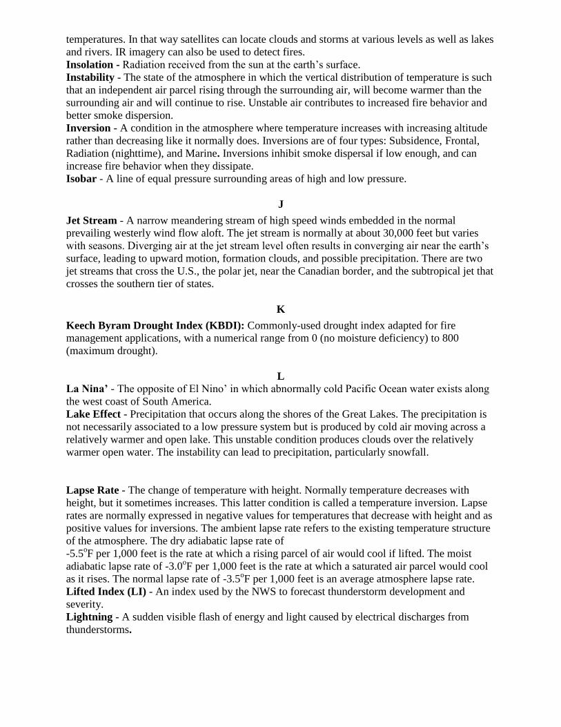
temperatures. In that way satellites can locate clouds and storms at various levels as well as lakes
and rivers. IR imagery can also be used to detect fires.
Insolation - Radiation received from the sun at the earth’s surface.
Instability - The state of the atmosphere in which the vertical distribution of temperature is such
that an independent air parcel rising through the surrounding air, will become warmer than the
surrounding air and will continue to rise. Unstable air contributes to increased fire behavior and
better smoke dispersion.
Inversion - A condition in the atmosphere where temperature increases with increasing altitude
rather than decreasing like it normally does. Inversions are of four types: Subsidence, Frontal,
Radiation (nighttime), and Marine. Inversions inhibit smoke dispersal if low enough, and can
increase fire behavior when they dissipate.
Isobar - A line of equal pressure surrounding areas of high and low pressure.
J
Jet Stream - A narrow meandering stream of high speed winds embedded in the normal
prevailing westerly wind flow aloft. The jet stream is normally at about 30,000 feet but varies
with seasons. Diverging air at the jet stream level often results in converging air near the earth’s
surface, leading to upward motion, formation clouds, and possible precipitation. There are two
jet streams that cross the U.S., the polar jet, near the Canadian border, and the subtropical jet that
crosses the southern tier of states.
K
Keech Byram Drought Index (KBDI): Commonly-used drought index adapted for fire
management applications, with a numerical range from 0 (no moisture deficiency) to 800
(maximum drought).
L La Nina’ - The opposite of El Nino’ in which abnormally cold Pacific Ocean water exists along
the west coast of South America.
Lake Effect - Precipitation that occurs along the shores of the Great Lakes. The precipitation is
not necessarily associated to a low pressure system but is produced by cold air moving across a
relatively warmer and open lake. This unstable condition produces clouds over the relatively
warmer open water. The instability can lead to precipitation, particularly snowfall.
Lapse Rate - The change of temperature with height. Normally temperature decreases with
height, but it sometimes increases. This latter condition is called a temperature inversion. Lapse
rates are normally expressed in negative values for temperatures that decrease with height and as
positive values for inversions. The ambient lapse rate refers to the existing temperature structure
of the atmosphere. The dry adiabatic lapse rate of
-5.5oF per 1,000 feet is the rate at which a rising parcel of air would cool if lifted. The moist
adiabatic lapse rate of -3.0oF per 1,000 feet is the rate at which a saturated air parcel would cool
as it rises. The normal lapse rate of -3.5oF per 1,000 feet is an average atmosphere lapse rate.
Lifted Index (LI) - An index used by the NWS to forecast thunderstorm development and
severity.
Lightning - A sudden visible flash of energy and light caused by electrical discharges from
thunderstorms.

Lightning Activity Level (LAL): A number, on a scale of 1 to 6, that reflects frequency and
character of cloud-to-ground lightning. An LAL of 6 refers to dry thunderstorms. The LAL is
not forecast in Minnesota.
Local Winds - Small scale convective winds of local origin cause by temperature differences.
Upslope winds during the day are examples of local winds.
Low Pressure Trough - An elongated area of relatively low atmospheric pressure, usually
extending from the center of a low pressure system. Troughs are areas of converging and
upward-moving air.
M
METAR- Meteorological Terminal Air Report - A coded weather report from ASOS and
AWOS automated airport weather stations. Reports are sent at least every hour or more often if
conditions change significantly. The reports are decoded and plotted on surface maps.
Middle Clouds - Clouds ranging in altitude from 6,500 to near 20,000 feet.
Millibar (Mb)- a unit of measure for atmospheric pressure. Multiplying millibars times 0.02953
yields inches of mercury. Multiplying inches of mercury times 33.86 yields millibars. Another
more universal name for a millibar is a HectaPascal (HPa).
Mixed Layer - The lowest layer of the atmosphere from the surface to the base of any
temperature inversion that may exist aloft. A well mixed layer has a lapse rate close to the dry
adiabatic lapse rate of -5.5o
F per 1,000 feet.
Mixing - The process of upward and downward motion in the atmosphere, particularly near the
surface of the earth.
Mixing Height - The layer in the atmosphere from the surface to the first inversion layer. It is in
this layer where vigorous mixing occurs due to convection.
NWS Spot - A web-based program for requesting and receiving spot weather forecasts.
O
Occluded Front - The front that is formed when and where a cold front overtakes a warm front
or a stationary front.
Outflow - Cold, denser air that descends from the base of a thunderstorm and then spreads out in
all directions. Outflow can travel several miles ahead of the thunderstorm and create gusty erratic
winds unexpectedly.
Outflow Boundary - The leading edge of thunderstorm outflow. If these boundaries meet
boundaries from other thunderstorms, new thunderstorm development is possible. Outflow
boundaries are sometimes visible on weather radar as thin, curved lines surrounding a
thunderstorm.
P
Palmer Drought Severity Index - An index used to gage the severity of drought conditions by
using a water balance equation to track water supply and demand. This index is calculated
weekly by the NWS.
Pibal - Pilot balloon. A method used by an Incident Meteorologist (IMET) at a fire to measure
the winds aloft. The IMET tracks the ascending balloon with a theodolite noting azimuth and
elevation every minute. He later uses these angles to calculate the winds. Launched with
equipment contained in the ATMU.
Pressure Gradient - The difference between the air pressure in one area and the air pressure in
another. The difference between High and Low pressure areas can be very small and result in
light winds. Or the air pressure differences can be large, resulting in strong winds flowing from

the High to the Low.
Profiler - A sampling device used to measure wind speeds aloft. A network of profilers is in the
Midwest. The most northern installation is at Wood Lake, Minnesota. Profiler data maps are
available on the internet.
Q QPF - Quantitative Precipitation Forecast - A forecast of the rainfall amount that might be
measured in a rain gage randomly placed in an area.
R
Radiational Cooling - The net loss of heat due to infrared radiation. Radiational cooling cools
the ground and the air immediately above. Over time, radiational cooling helps to develop a
nocturnal inversion, and that leads to poor smoke dispersion.
Radiosonde - an instrument carried aloft by balloon and tracked by ground equipment. The
instrument sends back temperature, humidity, and pressure. Ground equipment helps to calculate
wind speeds.
RAOB - Radiosonde Observation. A collection of information sent back from a radiosonde
instrument. The data are used to create a plotted sounding which shows the temperature,
humidity, and wind structure of the air aloft. RAOBs are used as basic information for the
atmospheric forecast models and for determining smoke management parameters.
Red Flag Warning - Term used by fire weather forecasters to alert forecast users to an ongoing
or imminent critical fire weather pattern.
Reflectivity - The ability of a radar target to return energy; used to estimate precipitation
intensity and rainfall rates. Reflectivity imagery this that most often display on NWS web sites
and on TV weathercasts. Cooler blue shades usually indicate light precipitation while warmer,
red hues imply stronger thunderstorms.
Relative Humidity (RH) - The ratio of the amount of moisture in the air, to the maximum
amount of moisture that air would contain if it were saturated. The ratio of the actual vapor
pressure to the saturated vapor pressure.
Remote Automatic Weather Station (RAWS) - An apparatus that automatically acquires,
processes, and stores local weather data for later transmission to the GOES Satellite, from which
the data is re-transmitted to an earth-receiving station for use in the National Fire Danger Rating
System.
Ridge - An elongated area of High Pressure.
Roll Cloud.- A horizontal, tubular cloud that may be seen on the leading edge of an outflow
from a thunderstorm.
RUC - Rapid Update Cycle. A short term atmospheric forecast model that uses recent surface
observations (METARs), satellite-calculated winds and temperatures, Doppler radar winds, and
other information from commercial aircraft.
S
Severe Weather Statement (SVS) - A text product issued by the local NWS office during
severe weather as an update to a Severe Thunderstorm Warning or Tornado Warning. The SVS
gives detailed information about when the leading edge of severe weather, gusty winds, hail, and
rain will pass designated locations.
Sea Breeze - A local wind that flows from a large body of water toward land. The sea breeze
results from the land heating up, causing the air to rise convectively. As this happens, air from
the cooler water flows inland. Sea breezes are often noted along Lake Superior, especially in the
spring. Sea breezes can be opposite to the established flow in the area, or it can enhance the local
wind if blowing in the same direction as the local winds.
Security Weather Watch - Observers are posted at one or more strategic locations in the
proximity of a fire to detect critical weather changes that might significantly affect the fire and to
report those changes to fire personnel.
Short Term Forecast - Sometimes called a NOWCAST. A short text product issued by the local
NWS office to supply detail on weather such as non-severe thunderstorms that is or soon will be
occurring at designated locations.
Short Wave - A kink in the broad scale upper flow. The east side of short waves area areas of
rising motion, while the west side are areas of downward motion. Forecasters track short waves
since short waves can often help to initiate or strengthen storms.
SkewT - A special graph for plotting upper air soundings or RAOBS. Forecasters use SkewTs to
determine atmospheric instability as well as to calculate smoke management parameters. The
temperature axis is shifted or skewed at an angle rather than being at right angles to the other
axis as is normally done. See also Stuve.
Slope Winds - Small scale convective winds that occur due to local heating and cooling of a
natural incline of the ground.
Smoke Management: - Application of fire intensities and meteorological processes to minimize
degradation of air quality during prescribed fires.
Sounding - See RAOB
SPC - Storm Prediction Center - The office that issues Severe Thunderstorm and Tornado
Watches. SPC also issues a daily fire weather related message on the potential for severe fire
weather conditions.
Spot Weather Forecast: - A special forecast issued to fit the time, topography, and weather of
each specific fire. These forecasts are issued upon request of the user agency and are more
detailed, timely, and specific than zone forecasts.
Squall line - Any non-frontal line or narrow band of active thunderstorms extending across the
horizon. It is of importance to fire behavior due to accompanying strong gusty winds and the
possibility of such a line passing between regular weather observation stations without being
reported.
Stability - The state of the atmosphere in which the vertical distribution of temperature is such
that an air parcel will resist vertical displacement from its level.
State of Weather - A brief description of current weather that expresses the amount of cloud
cover, kind of precipitation, and/or restrictions to visibility being observed at a weather
observation site.
Stratosphere - The layer of the atmosphere between the troposphere and the mesosphere where
the air is usually stable.
Stuve Diagram - (Pronounced STOO vee) A type of graph used to plot upper air soundings or
RAOBs and from which smoke management parameters can be calculated. See also SkewT.
Subsidence - An extensive sinking motion of air in the atmosphere, most frequently occurring in
high pressure areas of polar origin. The subsiding air is warmed by compression and becomes
more stable as a subsidence inversion develops. Of particular importance is the heating and
drying of the air.
Subsidence Inversion - A temperature inversion that forms under high pressure. The inversion
lowers with time.
Subtropical High - The semi-permanent area of high pressure centered in the south Atlantic and
Caribbean areas.

Surface Wind - The wind measured at 20 feet above the average top of the local vegetation. It is
often a combination of the local and general winds.
T
Thermal Belt - An area of mountainous slope (characteristically the middle third), where the top
of the radiation inversion intersects the slope. That area typically experiences the least variation
in diurnal temperature variation and has the highest average temperature, and thus the lowest
relative humidity. Its presence is most evident during clear weather with light wind.
Thunderstorm - Localized storm characterized by one or more electrical discharges.
Transport Winds - The average wind speed and direction of the horizontal wind within the
mixing layer.
Troposphere - The layer of the atmosphere from the earth’s surface up to the tropopause,
characterized by decreasing temperature with height (except, perhaps in thin layers, called
inversions), vertical wind motion, appreciable water vapor content, and sensible weather (clouds,
rain, etc.)
Trough - An elongated area of low pressure. Troughs are regions of converging air at low levels
which in turn results in upward vertical motion. See also Upper level disturbance, short wave.
Turbulence - Irregular motion of the atmosphere usually produced when air flows over a
comparatively uneven surface such as the surface of the earth; or when two currents of air flow
past or over each other in different directions or at different speeds.
U
Upper Level Disturbance - See Short Wave. A general term for any large scale or mesoscale
disturbance capable of producing upward motion (lift) in the middle or upper parts of the
atmosphere. Such disturbances can help initiate vertical motion or enhance existing vertical
motion.
V
Vorticity - A measure of the local rotation in a fluid flow. In weather analysis and forecasting, it
usually refers to the vertical component of rotation (i.e. rotation about a vertical axis) and is used
most often in reference to synoptic scale or mesoscale weather systems. By convention, positive
values indicate cyclonic rotation.
Veering Winds - Winds which shift in a clockwise direction with time at a given location (e.g.
from southerly to westerly), or which change direction in a clockwise sense with height (e.g.
southeasterly at the surface, turning to southwesterly aloft). The latter example is a form of
directional shear which is important for tornado formation. Contrast with backing winds.
Virga - Streaks or wisps of precipitation falling from a cloud but evaporating before reaching the
ground. In certain cases, shafts of virga may precede a microburst. Virga may also be present in
dry thunderstorms which produce “dry lightning”.
W
Warm Front - The leading edge of a relatively warm air mass which moves in such a way so
that warm air displaces colder air. Winds associated with warm frontal activity are usually light,
and mixing is limited. The atmosphere is relatively stable near a warm front when compared to
the air near a cold front.

Weather Information and Management System (WIMS): An interactive computer system
designed to accommodate the weather information needs of all federal and state natural resource
management agencies. Provides timely access to weather forecasts, current and historical
weather data, the National Fire Danger Rating System (NFDRS), and the National Interagency
Fire Management Integrated Database (NIFMID).
Wet Bulb Depression - The difference between the wet-bulb and dry-bulb temperatures as
measured by a psychrometer. The greater the web bulb depression, the drier the air.
Wet Bulb Temperature - The lowest temperature to which air can be cooled by evaporating
water into it at a constant pressure when the heat required for evaporation is supplied by the
cooling of the air. It is measured by the wet-bulb thermometer, which usually employs a wetted
wick on the bulb as a cooling devise through the process of evaporation. The drier the air, the
more evaporation from the wet bulb of a psychrometer can occur. The wet bulb temperature is an
indicator of the water vapor in the air. Relative humidity and dew point are calculated from
tables into which the dry bulb and wet bulb temperatures are used an inputs.
WSR-88D - The identifier for National Weather Service Doppler radar. Weather Surveillance
Radar deployed in 1988 with Doppler capability.
APPENDIX C
SMOKE MANAGEMENT
The Clean Air Act requires land management agencies to address the issue of smoke
management in its prescribed burns. The goal is to burn in atmospheric conditions that would
encourage smoke to rise to such a level that the smoke is dispersed as much as possible to reduce
a number of health and safety risks near the fire.
A Minnesota Smoke Management Plan (SMP) was created in the year 2000 and should be
considered the source document for any questions regarding the requirements or practices of
smoke management in Minnesota. The Plan was updated in 2008.
The National Weather Service will support the smoke management efforts of federal, state, and
local agencies as well as organizations involved in such burning. The NWS will provide three (3)
parameters used in smoke management in its Fire Weather Planning Forecasts. The NWS will
also include these parameters, upon request of the land agency, in spot forecasts.
The three weather parameters of smoke management forecasts are mixing layer (or depth),
transport winds, and dispersion index. For smoke management purposes, the mixing layer is
usually considered the lowest layers of the atmosphere bounded by the earth’s surface and the
bottom of any temperature inversion which may exist aloft. If a temperature inversion is based at
the surface, then there is little if any mixed layer. A temperature inversion would serve to trap
smoke at low levels or would prevent sufficient lofting of smoke to a level where winds would
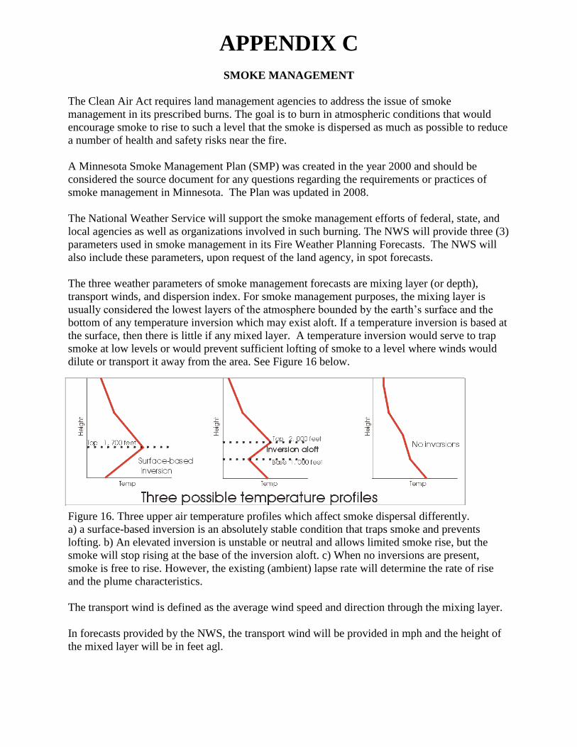
dilute or transport it away from the area. See Figure 16 below.
Figure 16. Three upper air temperature profiles which affect smoke dispersal differently.
a) a surface-based inversion is an absolutely stable condition that traps smoke and prevents
lofting. b) An elevated inversion is unstable or neutral and allows limited smoke rise, but the
smoke will stop rising at the base of the inversion aloft. c) When no inversions are present,
smoke is free to rise. However, the existing (ambient) lapse rate will determine the rate of rise
and the plume characteristics.
The transport wind is defined as the average wind speed and direction through the mixing layer.
In forecasts provided by the NWS, the transport wind will be provided in mph and the height of
the mixed layer will be in feet agl.

The transport wind may suggest the need for surveillance or resource location at downstream
areas for the purpose of minimizing the danger posed by spotting due to firebrands and to
determine the impacts of smoke on a sensitive area.
The Dispersion Index is detailed in the Minnesota Smoke Management Plan (SMP) in section
4.2.2. The index is intended to serve as a single adjective index which describes how smoke will
disperse on that day. The Dispersion Rate is given by the following formula as defined in the
Minnesota Smoke Management Plan:
Dispersion Index = (Mixing Height in feet) x (Transport Wind in knots)
The SMP contains guidelines for using the index and should be consulted for those details.
The Minnesota Smoke Management Plan (SMP) suggests the following interpretation of the
values: Dispersion Index Dispersion Rate
< 13,000 Poor
13,000 - 29,999 Fair
30,000 - 59,999 Good
60,000 or greater Excellent
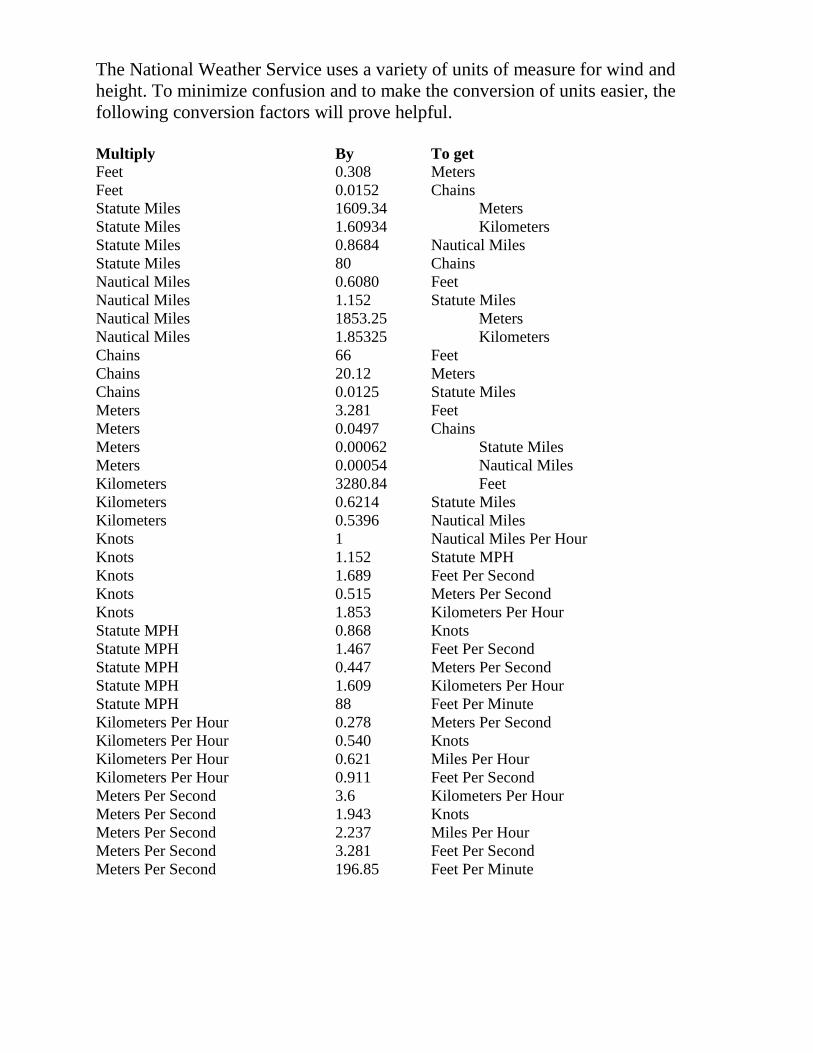
The National Weather Service uses a variety of units of measure for wind and
height. To minimize confusion and to make the conversion of units easier, the
following conversion factors will prove helpful.
Multiply By To get
Feet 0.308 Meters
Feet 0.0152 Chains
Statute Miles 1609.34 Meters
Statute Miles 1.60934 Kilometers
Statute Miles 0.8684 Nautical Miles
Statute Miles 80 Chains
Nautical Miles 0.6080 Feet
Nautical Miles 1.152 Statute Miles
Nautical Miles 1853.25 Meters
Nautical Miles 1.85325 Kilometers
Chains 66 Feet
Chains 20.12 Meters
Chains 0.0125 Statute Miles
Meters 3.281 Feet
Meters 0.0497 Chains
Meters 0.00062 Statute Miles
Meters 0.00054 Nautical Miles
Kilometers 3280.84 Feet
Kilometers 0.6214 Statute Miles
Kilometers 0.5396 Nautical Miles
Knots 1 Nautical Miles Per Hour
Knots 1.152 Statute MPH
Knots 1.689 Feet Per Second
Knots 0.515 Meters Per Second
Knots 1.853 Kilometers Per Hour
Statute MPH 0.868 Knots
Statute MPH 1.467 Feet Per Second
Statute MPH 0.447 Meters Per Second
Statute MPH 1.609 Kilometers Per Hour
Statute MPH 88 Feet Per Minute
Kilometers Per Hour 0.278 Meters Per Second
Kilometers Per Hour 0.540 Knots
Kilometers Per Hour 0.621 Miles Per Hour
Kilometers Per Hour 0.911 Feet Per Second
Meters Per Second 3.6 Kilometers Per Hour
Meters Per Second 1.943 Knots
Meters Per Second 2.237 Miles Per Hour
Meters Per Second 3.281 Feet Per Second
Meters Per Second 196.85 Feet Per Minute

APPENDIX D
HAINES INDEX
The NWS will provide the Haines Index in Fire Weather Planning Forecasts.
What is the Haines Index?
The Haines Index combines the effects of dry air and instability to determine the potential for
large fire growth. Its purpose is to identify weather conditions that may allow an existing fire to
spread rapidly or exhibit extreme fire behavior. It should NOT be used to predict the potential or
probability for wildfires to ignite. The Haines Index is most applicable to plume-dominated fires.
The Haines Index does not account for wind.
The Haines Index contains two components, one to assess the dry air, and the other to measure
the instability. Dry air affects fire behavior by lowering fuel moisture, which increases the
amount of fuel available to the fire. Instability is caused by warming the lower levels of the
atmosphere, cooling the higher levels, or by a combination of the two processes. An unstable air
mass promotes the formation of rising currents of air and thus increases the vertical extent of a
smoke column. Wildfires that burn in a dry, unstable environment can become plume-dominated
and are often able to generate their own strong surface winds. Ground elevation will determine
which of three levels in the atmosphere will be used to compute the Haines Index. In Minnesota,
the mid-level layer between 850 mb (around 5000 feet agl) and 700 mb (around 9000 feet agl)
will be used.
Computing the Haines Index
Haines Index = Stability + Moisture = A + B
Stability Term = 850 MB Temperature - 700 MB Temperature
Let A equal the following values according to the temperature differences
A = 1 when stability term is 5 degrees C or less
A = 2 when stability term is 6 to 10 degrees C
A = 3 when stability term is 11 degrees C or more
Large positive values of the stability term indicate an unstable layer of the atmosphere near the
earth’s surface. Negative values indicate a temperature inversion.
Moisture Term = 850 MB Temperature - 850 MB Dew Point Temperature
B = 1 when moisture term is 5 degrees C or less
B = 2 when moisture term is 6 to 12 degrees C
B = 3 when moisture term is 13 degrees C or more
The greater the value of this term, the drier the air is.

Significance of the Haines Index values
2 or 3 Very Low
4 Low
5 Moderate
6 High
An example calculation
850 MB Temperature = 20 degrees C
850 MB Dew Point = 15 degrees C
700 MB Temperature = 12 degrees C
Haines Index = Stability (A) + Moisture (B)
From the tables above
850 MB Temp - 700 MB Temp = 20 - 12 = 8 Stability is between 6 and 10, so let A = 2
850 MB Temp - 850 MB Dew point = 20 - 15 = 5 Moisture is less than 6, so let B = 1
A + B = 2 + 1 = 3.
An Index value of 3 corresponds to a “Very Low” category. The conclusion is that extreme fire
behavior would not be expected on this day.
A weakness of using the Haines Index is that the stability and moisture terms are calculated at
two fixed levels (850 and 700 MB). At times, making the calculations at slightly different levels
could lead to a significantly different Haines Index.

APPENDIX E Zones, Counties, Cities, and Weather Stations
Zones, County Warning Areas, Fire Weather Stations and Airport ASOS and AWOS Weather
Observation sites. A list of stations, zone names, and zone numbers is on the next page.

Zones, Counties, Cities, and Weather Stations
ZONE City Zone Name
1 Crookston West Polk
2 Ada Norman
3 Moorhead Clay
4 Hallock Kittson
5 Roseau/Greenbush Roseau
6 Baudette Lake of the Woods
7 Argyle W. Marshall
8 Grygla E. Marshall
9 Waskish N. Beltrami
10 International Falls Koochiching
11 Ely N. St. Louis
12 BWCAW N. Cook/Lake
13 Thief River Falls Pennington
14 Red Lake Falls Red Lake
15 Erskine E. Polk
16 Clearbrook N. Clearwater
17 Bemidji S. Beltrami
18 Effie N. Itasca
19 Hibbing C. St. Louis
20 Finland/Two Harbors Northshore/S. Lake
21 Grand Marais/ Northshore/S. Cook
Grand Portage
22 Mahnomen Mahnomen
23 Bagley S. Clearwater
24 Park Rapids Hubbard
25 Cass Lake N. Cass
26 Grand Rapids S. Itasca
27 Detroit Lakes W. Becker
28 Osage E. Becker
29 Breckenridge Wilkin
30 Fergus Falls W. Otter Tail
31 Ottertail E. Otter Tail
32 Wadena Wadena
33 Leech Lake S. Cass
34 Brainerd Crow Wing
35 Hill City N. Aitkin
36 Aitkin S. Aitkin
37 Duluth/Cloquet Carlton/S. St. Louis
38 Hinckley Pine
39 Wheaton Traverse
40 Elbow Lake Grant
41 Alexandria Douglas
42 Long Prairie Todd
43 Little Falls Morrison
44 Onamia Mille Lacs
45 Mora Kanabec
46 Ortonville Big Stone
47 Morris Stevens
48 Glenwood Pope
ZONE City Zone Name
49 St. Cloud Stearns
50 Sauk Rapids Benton
51 Elk River Sherburne
52 Cambridge Isanti
53 Taylors Falls Chisago
54 Madison Lac Qui Parle
55 Benson Swift
56 Montevideo Chippewa
57 Willmar Kandiyohi
58 Litchfield Meeker
59 Buffalo Wright
60 Minneapolis Hennepin
61 Anoka Anoka
62 St. Paul Ramsey
63 Stillwater Washington
64 Granite Falls Yellow Medicine
65 Renville Renville
66 Glencoe McLeod
67 Gaylord Sibley
68 Waconia Carver
69 Shakopee Scott
70 Hastings Dakota
71 Lake Benton Lincoln
72 Marshall Lyon
73 Redwood Falls Redwood
74 New Ulm Brown
75 St. Peter Nicollet
76 Montgomery Le Sueur
77 Faribault Rice
78 Zumbrota Goodhue
79 Wabasha Wabasha
80 Slayton Murray
81 Windom Cottonwood
82 St. James Watonwan
83 Mankato Blue Earth
84 Waseca Waseca
85 Owatonna Steele
86 Dodge Center Dodge
87 Rochester Olmsted
88 Winona Winona
89 Worthington Nobles
90 Jackson Jackson
91 Fairmont Martin
92 Blue Earth Faribault
93 Albert Lea Freeborn
94 Austin Mower
95 Preston Fillmore
96 Caledonia Houston
97 Pipestone Pipestone
98 Luverne Rock

2
APPENDIX F NOAA WEATHER RADIO STATIONS
NOAA Weather Radio transmitter sites. The circles indicate a radius within which the tone alert
should be available. Actual availability may vary due to terrain, weather conditions, or other
reasons. Smaller circles indicate lower-powered transmitters. Red, or blue colored circles
indicate existing stations or those which should be available in the near future. Frequencies are
shown in megahertz.

3
Appendix G
Instructions on How to Use the Internet Spot Forecast Request Form
4
From the Fire Weather Main Page on any National Weather Service web site, click on Internet
Request Spot Form. The Spot Forecast Request form will appear. This page auto-updates
every minute, so as new spot forecasts are requested or their status changes, you immediately see
the changes on the page. We call this the monitoring page. It should be noted that Spot
Forecasts on this Web Page are viewable by the public.
A nice feature available now is that Spot Forecasts can be viewed in a KML file in Google Earth
from the following NWS webpage http://radar.srh.noaa.gov/fire/. Simply click on the Spot
Forecast Request KML link on the right side of page to access a National Map of Spot Forecasts.
Some of the features on the Internet Spot Forecast Request Form Page include:
A) The current date with arrow keys allowing you to step back or forward to a particular date. A
calendar is also available, which will allow you to see how many spot forecasts were issued on a
certain date.
B) A map of the NWS office’s fire weather area of responsibility. A small box will appear
indicating the location of any spot requests. The box is colored coded to indicate if the spot
forecast is pending (green), which means you have submitted the request and the NWS is
working on the forecast. A purple box indicates the NWS has sent you a question with respect to
the spot forecast. A red box on the map means the spot forecast is complete and you can either
click on the red box or in the Name/Ignition Time/Status Box to see the forecast.
C) A link at the top of the monitoring page will take you back to the NWS Fire Weather Page.
So to submit a spot request online, simply click on SUBMIT A NEW SPOT REQUEST. You
will now be taken to the NWS SPOT FORECAST REQUEST page.
Information Page You Will Be Filling In
*** It is important to note that the elements colored in red are required fields! ***
Let's look at the information fields on this page...
1 _ Project Name: If your fire has a name, go ahead and put it in. Otherwise, let’s say the fire is 5
miles west of Litchfield, MN. Go ahead and enter in 5W of Litchfield, MN. Put in something
that you will be able to reference on the Spot Request Page because this is a required field.
* select the type of project. If it is a prescribed burn, please enter in the Ignition Time (using the
24 hour clock) and Date. The form defaults to an ignition time about ½ hour into the future. If it
is a wildfire, remove the default ignition time.
2 _ Requesting Agency: The Requesting Agency name and phone number are required. Fax
number and contact person are optional, but we consider those very important if we have any
questions or a breakdown in dissemination capabilities. You will only need to enter your agency
name, phone/fax numbers, and your name the first time you request a spot forecast. After that, it
will be filled in with the same information as your last request, assuming you use the same
computer. Please note that no other people other than you and the NWS will see this information.
Only the name of the requesting agency is shown.

5
You will also have to choose the Reason for the Spot Forecast Request Wildfire or Non-wildfire.
If a non-wildfire, you must also click on one of the three justifications. See Page 14 of the
Minnesota Fire Weather AOP for more details.
3 _ Location: You have a couple of options on this one, but they are important with respect to
having the location appear on the map. Proper location data will give us detailed map
information on the location of the fire and the terrain in the area.
* Enter the Latitude and Longitude of the fire (you can either specify degrees like 45.1486 or
degrees/minutes/seconds like 45 13 34).
4 _ Elevation: The top and bottom elevations of the fire are required. You can just enter the
numbers and do not need to mention the word feet. If the burn or fire is on flat ground, you can
enter a value in only one of the boxes, preferably the one labeled Top.
* Drainage is optional and once again references the river drainage basin the fire is in. If you do
not know it, go ahead and just submit the request anyway.
5 _ Aspect:. Use direction references such as N, NE, E, SE, S, SW, W, NW. If the fire or burn is
in flat terrain, you can type in FLAT.
6 _ Size: Enter the acreage if known, but it is an optional field.
7 _ Fuel: Please indicate the type of fuel, either using fuel model numbers, or better yet a
description of the fuel such as grass, slash, timber, etc. Also, if you can indicate the amount of
fuel sheltering, it helps us in providing accurate wind forecasts.
8 _ Observations: Current weather observations can improve the quality of a spot forecast. Please
enter in the information with respect to the observation. For each observation we need to know
where it is in relation to the burn, the elevation in feet, and the time (preferably using a 24 hour
clock). The wind (in mph) can be specified as N12 Gust 25 or North at 10 for example. You
must specify if the wind is a 20 foot wind or an eye-level wind. The temperature and wet bulb
values (in degrees F) should be entered and the RH (in percent) and dew point (in degrees F) can
also be entered if known. If you enter a temperature and wet bulb, the RH and dew point will be
calculated for you. Finally, any remarks about clouds, weather, or other important information
should be entered in the final box.
9 _ Primary Forecast Elements: Tell us what the forecast elements you need, or are particularly
important to the burn. There are six parameters listed for you. Select which ones you want a
forecast for, and the time period(s) you would like as well (available times are Today, Tonight,
and Tomorrow).
10 _ Remarks: Information such as wind direction or change in wind direction or speed which
would adversely affect the burn is very useful. Any other information which you feel would be
of use to the forecaster preparing the forecast is helpful. It is here where you would make a
request for Hysplit trajectory parcel forecasts, which may be of value for smoke management.
To obtain this information, simply add to the REMARKS block of the request
Hysplit<space>your email address. An example would be Hysplit [email protected]. The
Hysplit run will then be emailed to you. At this time, the lowest trajectory level available is 500
meters with others at 1000 and 3000 meters. Hysplit may be of more value in larger burns when

6
impacts would extend beyond 6 miles. It may also not be appropriate in situations with low
mixing heights – under an inversion.
11 _ Action: You now have three options. You can Submit Request, Cancel Request, or Clear
Form. When you hit Submit Request, various checks are performed on the data you have entered.
Some problems make it impossible for your request to be accepted (for example, if you forget to
enter a name for the burn), while others will produce warnings and messages for your
information. For example, even though drainage name is not required, it will still ask you if you
know what it is. You do not have to answer this question. If an error is found, you will be taken
to a page that describes the errors or minor problems. You can click on Go Back and Fix and
have the opportunity to make the necessary changes. You can click on Submit Request Anyway,
but we may send back a question or call you. You do have one more option and that is to Cancel
Request.
Other Important Information
* After you have submitted a spot forecast request, an individualized spot forecast web page
becomes available for that burn. The page automatically updates every minute so that as new
information becomes available for the burn, you see it immediately. Detailed maps of the area
around the burn are generated and displayed when they become available.
* Once the forecast is COMPLETED and made available to you, the page will not update
anymore. Thus, if we update the forecast, we would have to call you to inform you of the
upcoming change, since the page no longer updates or has a way to inform you that a change has
been sent. When you go back into the forecast, the only way you might pick up on the changed
forecast is at the top of the page it shows the time that the spot was requested and the time it was
issued. The issue time will have changed. Keep in mind that "sensitive" information like your
name, phone number, and the exact location of the burn are NOT visible to others - only to you
and the NWS.
* If we have questions about your request, we may send you back a question about it. If this
happens, the Status Box will show the word QUESTION and the box on the map will turn
purple. Click on this and you will see a big red box in the forecast page with our question.
Usually there is some problem with the request that you can probably fix (use the CHANGE
REQUEST link to do this, make your changes if necessary, then submit the request once again.
The purple box will return to green and the word QUESTION will change back to PENDING) or
you can call us.
* When your forecast is complete, it will show up in the spot forecast web page (clicking on the
red box in the map or COMPLETED in the Status Box can access the spot). On the forecast page
a Feedback box will appear where you can provide us information with respect to how the
forecast worked out, perhaps later in the day or several days down the road. This feedback helps
us to improve. Simply type in your feedback into the box and click on Send Feedback.
* At the bottom of the forecast page are links for actions that you can take. For example, you
can go "Back to Spot List" to return to the monitor page. If you need to delete a request, simply
click on "Delete Request".
* You can also click on "Copy Info to New Spot Request". This is helpful for burns that last over
several days. Rather than having to re-enter the data in the form to get a new forecast, you can

7
view the previous spot request and then copy all the location parameters to a new request using
this link. This will save you some time when filling out the request form.
Remember, you can also call the servicing NWS office in you have any questions.