2012-2014 STUDY GUIDES - ITC · PDF fileSTUDY GUIDES 2012-2014 ... University of Twente,...
155
STUDY GUIDES 2012-2014 Master of Science Degree Course in Geo-information Science and Earth Observation for Applied Earth Sciences, with specialization in Environmental & Engineering Geology C12-AES-MSc-02 17 September 2012 - 14 March 2014 University of Twente, Faculty ITC Bureau of Education and Research Services
Transcript of 2012-2014 STUDY GUIDES - ITC · PDF fileSTUDY GUIDES 2012-2014 ... University of Twente,...
STUDY GUIDES 2012-2014
Master of Science Degree Course in Geo-information Science and Earth Observation for
Applied Earth Sciences, with specialization in Environmental & Engineering Geology
C12-AES-MSc-0217 September 2012 - 14 March 2014
University of Twente, Faculty ITC Bureau of Education and Research Services

COLOFON
UNIVERSITY OF TWENTE FACULTY OF GEO-INFORMATION SCIENCE AND EARTH OBSERVATIONBureau of Education and Research Services
DATE LAST MODIFIED10 March 2014
PUBLISHED VERSIONVersion 1.6
POSTAL ADDRESSPO Box 217 7500 AE Enschede
WEBSITEwww.itc.nl
COPYRIGHT© ITC, Faculty of Geo-Information Science and Earth Observation of the University ofTwente, The Netherlands.Text and numerical material from this publication may be reproduced in print, byphotocopying or by any other means with the permission of ITC if the source is mentioned.
PUBLISHED BYUniversity of TwenteFaculty of Geo-Information Science and Earth ObservationBureau of Education and Research Services

FOREWORD
DEAR PARTICIPANTS IN THE MSC PROGRAMME,
Welcome to the Faculty ITC of the University of Twente. Having left your family and country, you have come to ITC to further your education. We hope that the course you have selected will fulfil your expectations.
Education in the Master of Science courses at ITC is characterised by: a mixture of theory and practice, often including participants' own experiences; a core curriculum for Remote Sensing (RS) and Geo-information Systems (GIS), common for all MSc
students; deepening your knowledge in one of the domains; acquiring research skills; choice options according to individual (research) interests.
We are pleased to present you this study guide for the 2012/2014 Master of Science degree programme offered full-time at the Faculty ITC Enschede. This study guide gives you information on the MSc programme, an overview of the blocks and the detailed content of the course modules. ITC offers the MSc programme in Geo-Information Science and Earth Observations in the following domains: Applied Earth Sciences (AES); Geoinformatics (GFM); Land Administration (LA); Natural Resources Management (NRM); Urban Planning and Management (UPM); Water Resources and Environmental Management (WREM); Governance and Spatial Information Management (GSIM).
But there is more to life at ITC than only education. You have arrived at an Institute with more than 300 students from over 70 countries. Furthermore, also ITC staff is originating from more than 25 countries: a truly international environment where you will be able to meet colleagues from all over the world. ITC is organising all sorts of social, cultural and sports activities. Well-known are the International Sports Tournament, the International Food Festival and the International Cultural Event. We would like to encourage you to participate in many if not all of these events and to make new friends in the process.
We will do our best to provide you with the quality of education that you expect from our Institute.
We wish you the best of success during your studies and a pleasant stay at ITC and in the Netherlands.
Prof. Dr. Ir. A. VeldkampRector/Dean Faculty ITC


CONTENTS
INTRODUCTION .................................................................................................................................................................................1Course structure ..................................................................................................................................................................................3Teaching period ...................................................................................................................................................................................6Events, holidays and breaks ................................................................................................................................................................7Roles within the curriculum ..................................................................................................................................................................8Course objectives ..............................................................................................................................................................................10Teaching and learning approach .......................................................................................................................................................12Sources of information .......................................................................................................................................................................14
BLOCK 1: CORE MODULES ...........................................................................................................................................................15GI Science and Earth Observation: a process-based approach........................................................................................................17
BLOCK 2: COURSE MODULES ......................................................................................................................................................21Image Interpretation and Active Methods in Remote Sensing...........................................................................................................23Stream 1A: Remote Sensing and GIS for Geological Exploration .....................................................................................................25Stream 2A: Rock and Soil Mechanics in Engineering Geology .........................................................................................................27Stream 3A: Remote Sensing and GIS for Natural Hazard Assessment ............................................................................................29Common topic: Geostatistics .............................................................................................................................................................31Stream 1B: Remote Sensing and GIS in Mineral Exploration ...........................................................................................................33Stream 3B: Natural Hazards Modeling and Risk Assessment...........................................................................................................35
BLOCK 3: RESEARCH PROFILE ....................................................................................................................................................39Research Skills ..................................................................................................................................................................................41Advanced topic(s) ..............................................................................................................................................................................43Geostatistics ......................................................................................................................................................................................45Laser Scanning ..................................................................................................................................................................................47Modelling natural resources degradation...........................................................................................................................................49Spatial data for disaster risk management ........................................................................................................................................51SAR and SAR interferometry, with applications ................................................................................................................................54Geophysics and 3D geo-visualization of the subsurface ...................................................................................................................56Spatio-temporal modeling, analytics, and visualization .....................................................................................................................59Spatial databases and their design....................................................................................................................................................61Assessment of the Effect of Climate Change on Agro-ecological Systems Using Optical and SAR Remote Sensing and GIS .......63Species Distribution Modeling (SDM) and Climate Change Impact ..................................................................................................65RS/GIS analysis methods to support Food Security studies .............................................................................................................67Participatory mapping and GIS ..........................................................................................................................................................70Analysis of intra-urban socio-spatial patterns ....................................................................................................................................72Advanced urban landuse change and modelling ...............................................................................................................................74Integrated assessment: applying principles of cost benefit analysis and economics in spatial planning ..........................................77HYDROSAT: Observing the Water Cycle from Space ......................................................................................................................80Advanced topic(s) ..............................................................................................................................................................................82Advanced image analysis ..................................................................................................................................................................843D Geoinformation from imagery.......................................................................................................................................................86Data analysis in earth, water and natural resources studies .............................................................................................................88Use, users and usability.....................................................................................................................................................................90Design and implementation of Geoinformation Services for SDI.......................................................................................................92Strategic Environmental Assessment (SEA) and Environmental Impact Assessment (EIA) applying Spatial Decision Support tools94Spatial-temporal models for Food Security studies ...........................................................................................................................97Land governance .............................................................................................................................................................................100Collaborative planning and decision support systems applied in decision rooms ...........................................................................102

Networks and spatial interaction modelling .....................................................................................................................................104Sensors, empowerment and accountability .....................................................................................................................................106Land Surface Modeling and Data Assimilation ................................................................................................................................108Climate change impacts and adaptation - Analysis and monitoring techniques of climate change.................................................110Research themes/ MSc Qualifier .....................................................................................................................................................112Model characterisation and quality assessment ..............................................................................................................................115Spatial Data Analysis for quantitative field studies ..........................................................................................................................118Regional geologic interpretation ......................................................................................................................................................120Geodata and service provision in crises situations: supporting UN Peace-keeping operations ......................................................122Change detection of vegetation types in Buursezand area .............................................................................................................124Field data collection and mapping and modelling of rare species distributions ...............................................................................126Crop production modelling and monitoring ......................................................................................................................................128Biomass estimation and carbon assessment for climate change research .....................................................................................130PLUS research methods & techniques ............................................................................................................................................132Water Cycle and Climate .................................................................................................................................................................134
BLOCK 4: INDIVIDUAL MSC RESEARCH ....................................................................................................................................137MSc Research and Thesis Writing ..................................................................................................................................................139Theme: Acquisition and quality of geo-spatial information (ACQUAL) ............................................................................................141Theme: 4D-EARTH..........................................................................................................................................................................142Theme: Spatio-temporal analytics, maps and processing (STAMP) ...............................................................................................143Theme: Forest Agriculture and Environment in the Spatial Sciences (FORAGES).........................................................................144Theme: People, Land and Urban Systems (PLUS) .........................................................................................................................145Theme: Water Cycle and Climate (WCC) ........................................................................................................................................146


INTRODUCTION

INTRODUCTION
3
COURSE STRUCTURE
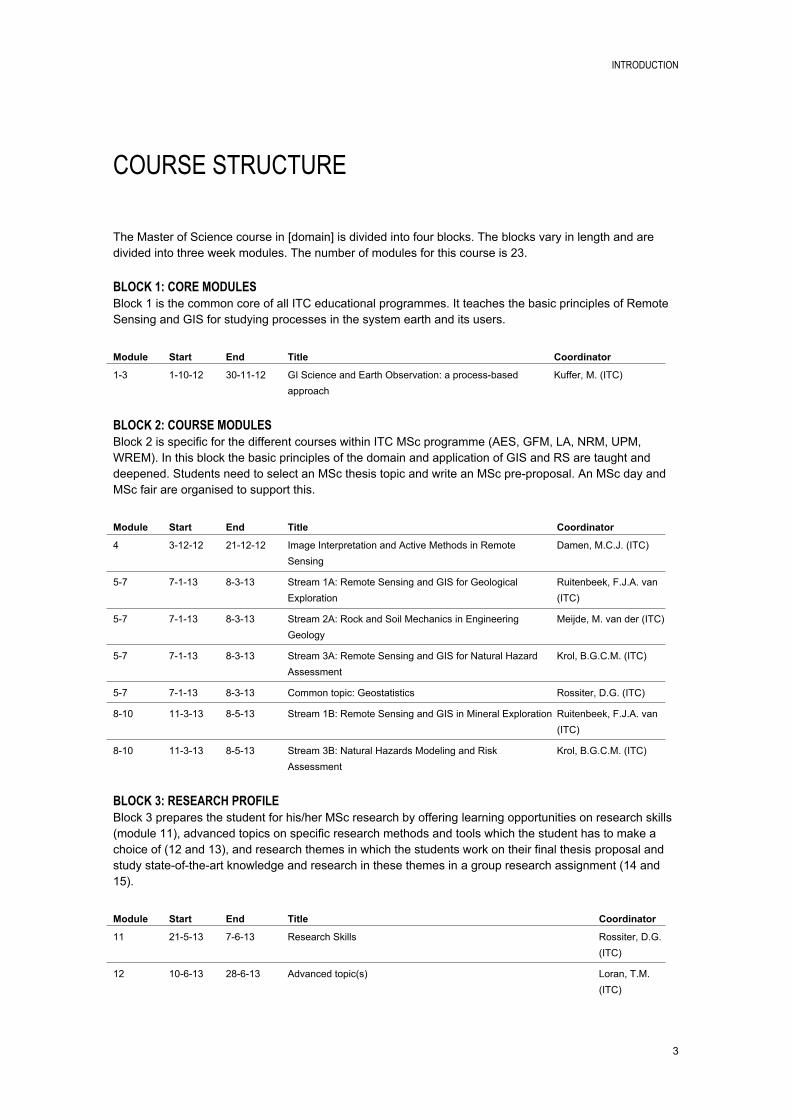
The Master of Science course in [domain] is divided into four blocks. The blocks vary in length and are divided into three week modules. The number of modules for this course is 23.
BLOCK 1: CORE MODULESBlock 1 is the common core of all ITC educational programmes. It teaches the basic principles of Remote Sensing and GIS for studying processes in the system earth and its users.
Module Start End Title Coordinator
1-3 1-10-12 30-11-12 GI Science and Earth Observation: a process-based approach
Kuffer, M. (ITC)
BLOCK 2: COURSE MODULESBlock 2 is specific for the different courses within ITC MSc programme (AES, GFM, LA, NRM, UPM, WREM). In this block the basic principles of the domain and application of GIS and RS are taught and deepened. Students need to select an MSc thesis topic and write an MSc pre-proposal. An MSc day and MSc fair are organised to support this.
Module Start End Title Coordinator
4 3-12-12 21-12-12 Image Interpretation and Active Methods in Remote Sensing
Damen, M.C.J. (ITC)
5-7 7-1-13 8-3-13 Stream 1A: Remote Sensing and GIS for Geological Exploration
Ruitenbeek, F.J.A. van (ITC)
5-7 7-1-13 8-3-13 Stream 2A: Rock and Soil Mechanics in Engineering Geology
Meijde, M. van der (ITC)
5-7 7-1-13 8-3-13 Stream 3A: Remote Sensing and GIS for Natural Hazard Assessment
Krol, B.G.C.M. (ITC)
5-7 7-1-13 8-3-13 Common topic: Geostatistics Rossiter, D.G. (ITC)
8-10 11-3-13 8-5-13 Stream 1B: Remote Sensing and GIS in Mineral Exploration Ruitenbeek, F.J.A. van (ITC)
8-10 11-3-13 8-5-13 Stream 3B: Natural Hazards Modeling and Risk Assessment
Krol, B.G.C.M. (ITC)
BLOCK 3: RESEARCH PROFILEBlock 3 prepares the student for his/her MSc research by offering learning opportunities on research skills (module 11), advanced topics on specific research methods and tools which the student has to make a choice of (12 and 13), and research themes in which the students work on their final thesis proposal and study state-of-the-art knowledge and research in these themes in a group research assignment (14 and 15).
Module Start End Title Coordinator
11 21-5-13 7-6-13 Research Skills Rossiter, D.G. (ITC)
12 10-6-13 28-6-13 Advanced topic(s) Loran, T.M. (ITC)
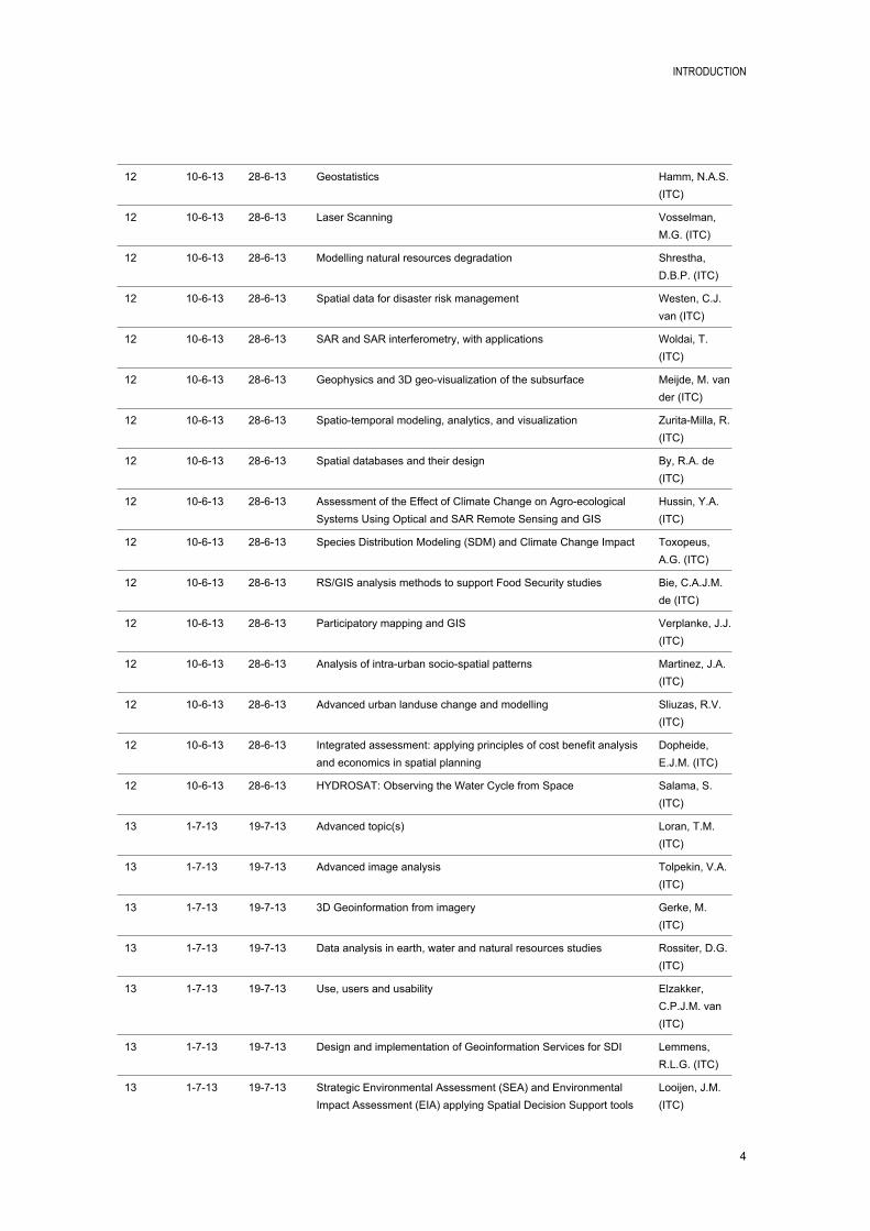
INTRODUCTION
4
12 10-6-13 28-6-13 Geostatistics Hamm, N.A.S. (ITC)
12 10-6-13 28-6-13 Laser Scanning Vosselman, M.G. (ITC)
12 10-6-13 28-6-13 Modelling natural resources degradation Shrestha, D.B.P. (ITC)
12 10-6-13 28-6-13 Spatial data for disaster risk management Westen, C.J. van (ITC)
12 10-6-13 28-6-13 SAR and SAR interferometry, with applications Woldai, T. (ITC)
12 10-6-13 28-6-13 Geophysics and 3D geo-visualization of the subsurface Meijde, M. van der (ITC)
12 10-6-13 28-6-13 Spatio-temporal modeling, analytics, and visualization Zurita-Milla, R. (ITC)
12 10-6-13 28-6-13 Spatial databases and their design By, R.A. de (ITC)
12 10-6-13 28-6-13 Assessment of the Effect of Climate Change on Agro-ecological Systems Using Optical and SAR Remote Sensing and GIS
Hussin, Y.A. (ITC)
12 10-6-13 28-6-13 Species Distribution Modeling (SDM) and Climate Change Impact Toxopeus, A.G. (ITC)
12 10-6-13 28-6-13 RS/GIS analysis methods to support Food Security studies Bie, C.A.J.M. de (ITC)
12 10-6-13 28-6-13 Participatory mapping and GIS Verplanke, J.J. (ITC)
12 10-6-13 28-6-13 Analysis of intra-urban socio-spatial patterns Martinez, J.A. (ITC)
12 10-6-13 28-6-13 Advanced urban landuse change and modelling Sliuzas, R.V. (ITC)
12 10-6-13 28-6-13 Integrated assessment: applying principles of cost benefit analysis and economics in spatial planning
Dopheide, E.J.M. (ITC)
12 10-6-13 28-6-13 HYDROSAT: Observing the Water Cycle from Space Salama, S. (ITC)
13 1-7-13 19-7-13 Advanced topic(s) Loran, T.M. (ITC)
13 1-7-13 19-7-13 Advanced image analysis Tolpekin, V.A. (ITC)
13 1-7-13 19-7-13 3D Geoinformation from imagery Gerke, M. (ITC)
13 1-7-13 19-7-13 Data analysis in earth, water and natural resources studies Rossiter, D.G. (ITC)
13 1-7-13 19-7-13 Use, users and usability Elzakker, C.P.J.M. van (ITC)
13 1-7-13 19-7-13 Design and implementation of Geoinformation Services for SDI Lemmens, R.L.G. (ITC)
13 1-7-13 19-7-13 Strategic Environmental Assessment (SEA) and Environmental Impact Assessment (EIA) applying Spatial Decision Support tools
Looijen, J.M. (ITC)

INTRODUCTION
5
13 1-7-13 19-7-13 Spatial-temporal models for Food Security studies Bie, C.A.J.M. de (ITC)
13 1-7-13 19-7-13 Land governance Tuladhar, A.M. (ITC)
13 1-7-13 19-7-13 Collaborative planning and decision support systems applied in decision rooms
Boerboom, L.G.J. (ITC)
13 1-7-13 19-7-13 Networks and spatial interaction modelling Zuidgeest, M.H.P. (ITC)
13 1-7-13 19-7-13 Sensors, empowerment and accountability Georgiadou, P.Y. (ITC)
13 1-7-13 19-7-13 Land Surface Modeling and Data Assimilation Velde, R. van der (ITC)
13 1-7-13 19-7-13 Climate change impacts and adaptation - Analysis and monitoring techniques of climate change
Timmermans, W.J. (ITC)
14-15 29-7-13 6-9-13 Research themes/ MSc Qualifier Loran, T.M. (ITC)
14-15 29-7-13 6-9-13 Model characterisation and quality assessment Stein, A. (ITC)
14-15 29-7-13 6-9-13 Spatial Data Analysis for quantitative field studies Jetten, V.G. (ITC)
14-15 29-7-13 6-9-13 Regional geologic interpretation Ruitenbeek, F.J.A. van (ITC)
14-15 29-7-13 6-9-13 Geodata and service provision in crises situations: supporting UN Peace-keeping operations
Turdukulov, U.D. (ITC)
14-15 29-7-13 6-9-13 Change detection of vegetation types in Buursezand area Weir, M.J.C. (ITC)
14-15 29-7-13 6-9-13 Field data collection and mapping and modelling of rare species distributions
Weir, M.J.C. (ITC)
14-15 29-7-13 6-9-13 Crop production modelling and monitoring Weir, M.J.C. (ITC)
14-15 29-7-13 6-9-13 Biomass estimation and carbon assessment for climate change research
Weir, M.J.C. (ITC)
14-15 29-7-13 6-9-13 PLUS research methods & techniques Groenendijk, E.M.C. (ITC)
14-15 29-7-13 6-9-13 Water Cycle and Climate Salama, S. (ITC)
BLOCK 4: INDIVIDUAL MSC RESEARCHIn Block 4 the student works individually on his/her MSc thesis. It is required to have an approved MSc research proposal before entering this block. Formal assessment will be given at the mid-term presentation and at the final MSc exam.
Module Start End Title Coordinator
16-23 9-9-13 28-2-14 MSc Research and Thesis Writing Loran, T.M. (ITC)
INTRODUCTION
6
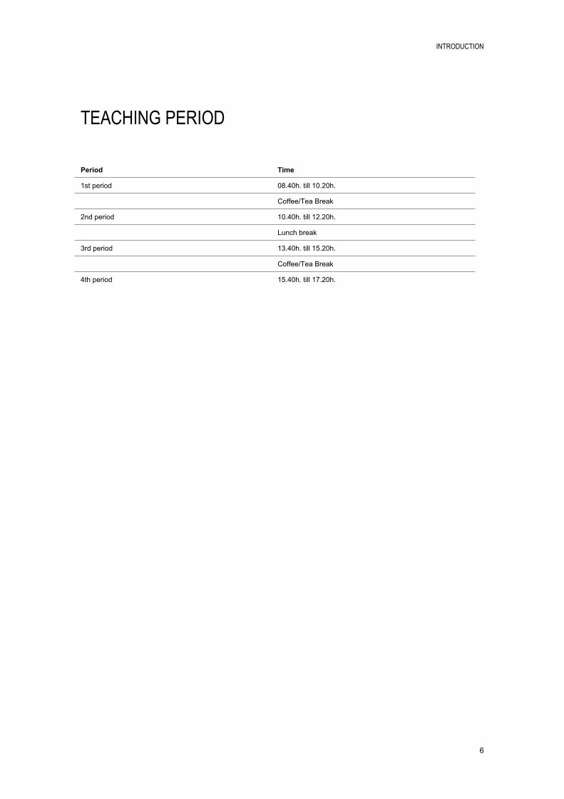
TEACHING PERIOD
Period Time
1st period 08.40h. till 10.20h.
Coffee/Tea Break
2nd period 10.40h. till 12.20h.
Lunch break
3rd period 13.40h. till 15.20h.
Coffee/Tea Break
4th period 15.40h. till 17.20h.
INTRODUCTION
7
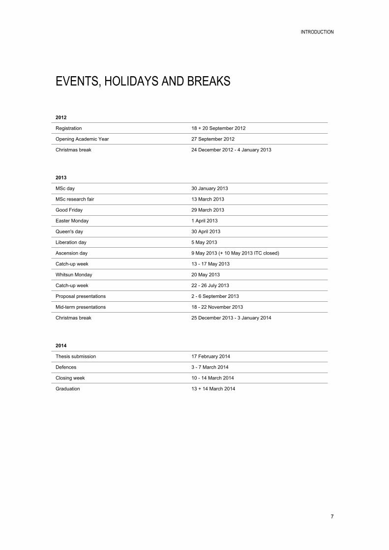
EVENTS, HOLIDAYS AND BREAKS
2012
Registration 18 + 20 September 2012
Opening Academic Year 27 September 2012
Christmas break 24 December 2012 - 4 January 2013
2013
MSc day 30 January 2013
MSc research fair 13 March 2013
Good Friday 29 March 2013
Easter Monday 1 April 2013
Queen's day 30 April 2013
Liberation day 5 May 2013
Ascension day 9 May 2013 (+ 10 May 2013 ITC closed)
Catch-up week 13 - 17 May 2013
Whitsun Monday 20 May 2013
Catch-up week 22 - 26 July 2013
Proposal presentations 2 - 6 September 2013
Mid-term presentations 18 - 22 November 2013
Christmas break 25 December 2013 - 3 January 2014
2014
Thesis submission 17 February 2014
Defences 3 - 7 March 2014
Closing week 10 - 14 March 2014
Graduation 13 + 14 March 2014

INTRODUCTION
8
ROLES WITHIN THE CURRICULUM
Course Directordr. Werff, H.M.A. van der (ITC)
Room: ITC 5-029Phone: +31 53 4874535Email: [email protected]
Course Secretary Wolters, C.M. (ITC)
Room: ITC 1-109Phone: +31 53 4874328Email: [email protected]
CENTRAL COURSE DIRECTORThe Central Course Director is responsible for the development and implementation of the ITC central curriculum elements (amongst others the Core), joint courses and distance education. The Education Director can delegate tasks to the Central Course Director.
COURSE DIRECTOR/COORDINATORThe Course Director or Course Coordinator is authorised by and accountable to the Head of the Scientific Department as well as the Education Director, regarding development and implementation of all courses within a specific domain and their specialisations. The Course Director or Course Coordinator is responsible for execution of the courses, including logistic aspects, fieldwork, purchase of all materials, the administration of information regarding students and their study results, diplomas and course records, and course content archiving.
COURSE SECRETARYThe Course Secretary gives administrative and logistic support during the execution of the course and assists Course Directors or Course Coordinator as well as Module Coordinators. She is the first point of contact for students requiring information regarding the course. She is part of the Bureaus Education and Research.
EDUCATION DIRECTORThe Education Director is the Dean's delegate on education matters and is a member of the Management Team of the Faculty ITC. He is responsible for preparation and implementation of education policy, monitoring the implementation of ITC's programs and courses by the Course Directors and the quality and quality assurance of these courses.

INTRODUCTION
9
EXAMINATION BOARDThe Examination Board has to decide in an objective and professional manner whether a student has achieved all knowledge, skills and attitudes, as defined in the OER (Onderwijs- en Examenregeling) to award a degree, diploma or certificate of a specific course. Therefore, the Examination Board monitors and is involved in all aspects of assessment; From policy on assessment (via appointment of assessors) to the decision about complaints related to assessment.
MODULE COORDINATOREach module is coordinated by a staff member of the Scientific departments. He or she is responsible for the organisation and execution of the entire module, and is first point of contact for staff when questions arise.
PROGRAM COMMITTEEThe Programme Committee advices the Dean and the Course Directors on any matter pertaining to ITC's Master level course and non-degree courses, implemented by the Course Directors. This includes advice on the curricula, quality assurance, education and assessment regulations and education policy.
PROPOSAL ASSESSMENT BOARDMSc students have to develop a research proposal for their thesis and defend this to the Proposal Assessment Board (PAB) at the end of Module 15 of the MSc programme. The PAB decides whether the research proposal is acceptable to ITC standards and complies with (inter)national standards. A positive decision of the PAB grants the MSc student entrance to Block 4, the research phase, of the MSc programme.
STUDENT ADVISOREach student is assigned a Student Advisor who can advice the student in study-related issues and can answer study-related questions. In many courses the Course Director or Course Coordinator has the role of Student Advisor.
SUPERVISOREach MSc student will be assigned to a Supervisor for the development of their research proposal and the execution of their thesis research.
THESIS ASSESSMENT BOARDThe Thesis Assessment Board is responsible for the assessment of the MSc thesis at the end of the MSc degree programme.

INTRODUCTION
10
COURSE OBJECTIVES
MASTER OF SCIENCE DEGREE PROGRAMMEAt successful completion of the Master of Science degree programme, the student is able to:1. Analyse problems encountered in professional practice and develop appropriate methods for studying
and/or solving these problems.2. Apply appropriate methods for collecting, acquiring and verifying spatial data.3. Use geo-information science and earth observation to generate, integrate, analyse and display spatial
data.4. Evaluate and apply relevant and appropriate methods and models for data analysis and problem
solving.5. Apply research skills to formulate and carry out an independent research project.6. Communicate and defend findings of thesis work.
These objectives at programme level are worked out into objectives at course and module level.
The main aim of the course in Applied Earth Sciences is to equip participants with the necessary knowledge and skills to use spatial information, Geographic Information Systems and Remote Sensing techniques in the context of problems that are related to the field of earth sciences. Emphasis is put on the meaningful and creative use of these tools and techniques from an earth science background, but with an open eye for other disciplines and scientific fields.
APPLIED EARTH SCIENCESA number of generic competencies and skills that will be obtained during the course are: Application oriented problem solving; Able to work in teams with specialists of other disciplines; Continuous critical learning attitude, flexible, pro-active, have a vision; Ability to respond to changing demands and opportunities (from society and discipline); Ability to respond to developing theory as well as improved techniques; Confident communicator, both to peers as well as to a general public; Ability to act in various cultural environments.
For each of the three streams a number of objectives can be identified which are briefly described below.
EARTH RESOURCES EXPLORATIONAIMThis stream aims to strengthen capacity to apply earth observation and geoinformation techniques to explore and prioritize areas for exploitation of earth resources (considering costs, benefits and potential impacts on the environment).
This is done through the investigation of mineral occurrences with exploration potential, making use of state-of-the-art techniques in GIS, remote sensing and modelling, with special attention for on-site and off-site environmental impact of extraction activities.
EXPECTED RESPONSIBILITIESSupply geological information to contribute within a multidisciplinary context including economic and environmental perspectives to prioritization of areas for mineral exploration. Define, collect, manage, process and analyze earth observation data as well as ground observations and geoinformation techniques to localize and quantify earth resources.
INTRODUCTION
11
GEOLOGICAL ENGINEERING AND HAZARDS
AIM
The course aims to strengthen capacity on how to apply GIS, remote sensing and geophysics in engineering geology with a particular focus on engineering activities in the field of geological hazards (slope stability, earthquakes). This is done through application of knowledge on soil and rock mechanics for engineering purposes while incorporating remote sensing, geophysics, and modelling techniques in addressing geohazards related to engineering geology activities.
EXPECTED RESPONSIBILITIES
Providing geological and geotechnical information to civil engineering and building projects. Assess and perform necessary engineering geological measures in the case of environmental or geohazard related planning, construction and/or damage. Understanding spatial and temporal variations in physical parameters at the surface and in the subsurface gives the necessary insight into the extent, for example, seismic shaking and amplification or occurrences of landslides.
NATURAL HAZARDS AND DISASTER RISK MANAGEMENTAIMThis stream aims to strengthen capacity to apply spatial information and earth observation techniques in the identification, mapping and monitoring of geo-hazards and in the quantification of vulnerability and risk, in order to prevent and reduce damage done to people, their property and the physical resource base on which they depend.
EXPECTED RESPONSIBILITIESStudy the occurrence and extent of natural disasters (volcanic eruptions, earthquakes, landslides, flooding and coastal hazards) as well as gradual degradation processes (erosion, desertification, salinization, land subsidence), including their distribution, frequency and intensity; Study susceptibility of society to the damage caused by these events and determine their environmental impact; Establish risk assessment methods, design hazard-warning systems and develop damage reduction scenarios. Develop spatially explicit land degradation control and restoration scenarios; Communicate with relevant stakeholders throughout the process of geo-hazard studies and communicate results effectively and efficiently.

INTRODUCTION
12
TEACHING AND LEARNING APPROACH
The academic profile of the MSc programme puts strong emphasis on the scientific discipline, a scientific approach, basic intellectual skills, co-operation and communication and the temporal and social context of research. The emphasis on doing research and/or designing or developing new methods or techniques depends on the application domain.
Multi-disciplinary research is an important focus for the MSc programme because (applied) research in practice seldom concerns one discipline but is more likely to be multidisciplinary. Students have to be prepared for that. Starting with a sound basis in their own domain they will be brought into learning situations in which students from different domains work together. It should be noted that most if not al research at ITC is already multidisciplinary in nature. This is evident in the wide scope of expertise within departments, and the common denominator to carry out applied research contributing towards development related issues as specified in ITC's mission.
In their profession, the graduates have to apply knowledge and skills independently. The MSc programme is therefore focused at handing over the control of the learning process to the student. At the beginning of the programme, the teacher will have the main control and the programme will contain some choices, especially concerning preparation for the MSc research.
The choices should be motivated, fit to the envisaged research trajectory, and be accepted by the course director. During the programme the teacher role will develop towards the role of advisor. The student takes the lead in his/her own learning process by developing his/her own learning plan within the MSc framework and guidelines. The teacher supports this as a coach (while still passing on his/her experience).
BLOCK 1: MAINLY TEACHER LEDIn Block 1 the teacher takes the lead. He/she defines the content to be studied and learning tasks and exercises which have to be executed. Students can make limited choices between learning strategies and learning tasks. The number of contact hours between teacher and students is relatively large in this stage, mainly consisting of lectures and supervised practical exercises. Each student will be assigned a student advisor in Module 1 for advice on study related matters, especially the choice trajectory towards the MSc topic selection, but also for day-to-day problems, remedial self-study, etc. The student advisor is assigned for the whole MSc course.
HANDING OVER CONTROL FROM THE TEACHER TO THE STUDENT

INTRODUCTION
13
BLOCK 2: TEACHER AND STUDENT LEDIn Block 2 both the teacher and the student take the lead. The teacher defines the framework in which the student can make his/her own choices about study tasks. The amount of choice options varies across the different courses (or streams). The student has to start thinking about his/her MSc research topic and consult staff about its feasibility. The number of contact hours between teacher and students is reduced in favour of group work and independent study and assignments.
BLOCK 3: MAINLY STUDENT LEDIn Block 3 the student takes control by choosing advanced subjects and a research theme which fit within his/her MSc thesis topic. The student works on the final version of MSc research proposal and consults his student advisor and other specialised staff about its feasibility and quality. The final version of the MSc research proposal has to be presented and defended by the student for the Thesis Admission Committee. The number of contact hours between teacher and student is further reduced to make room for independent study by the student. Two MSc supervisors (first and second) are assigned for MSc supervision at the beginning of Block 3.
BLOCK 4: STUDENT LEDIn Block 4 the student works individually and independently on his/her MSc research project. This will be supported by meetings with the MSc supervisors and capita selecta meetings, organised by the research themes. The student is responsible for progress and quality of his/her own research project and its defence at the end. The number of contact hours between teacher and students is reduced to a minimum in this period. It is therefore wise to look for peer support and peer review opportunities in this phase, which is offered in the research theme where staff, PhD and MSc students are together.
DOMAIN MODULESThe second block is a block that deals with the thematic content (or domain orientation) that is relevant for the AES program, and includes issues that are important in solving problems in Applied Earth Sciences. Use is made extensively of the tools and techniques that have been presented in the first block. Within the domain of Applied Earth Sciences it is possible to choose from three specializations or streams: Earth Resources Exploration, Geological Engineering and Hazards, and Natural Hazards and Disaster Risk Management.
The second block includes a number of common subjects which will be attended by all AES students because they are considered relevant for the two specializations. Besides that there are lectures and practicals which are more specifically aimed at the specializations that are available. The lectures and practicals do not strictly follow a modular structure, but are mixed and linked in time.
The second block contains a number of projects that stretch out over several modules. The projects are scheduled in such a way that taught subjects that are necessary for carrying out the projects are presented at appropriate times. They provide the opportunity to develop practical skills and allow for actually applying what has been taught in the theoretical sessions. The projects encompass the entire scope of data acquisition, modelling, analysis, and reporting in a geo-information context, and are complemented by supporting lectures on programme-wide earth science and geo-information topics, as well as stream-specific topics. Participants will work in small teams for the projects.

INTRODUCTION
14
SOURCES OF INFORMATION
STUDY GUIDE IN DIGITAL FORMATwww.itc.nl/studyguide
ASSESSMENT REGULATIONSwww.itc.nl/assessment-regulations
ITCwww.itc.nl
UNIVERSITY OF TWENTEwww.utwente.nl/en

INTRODUCTION
15
BLOCK 1: CORE MODULES

BLOCK 1: CORE MODULES
17
GI SCIENCE AND EARTH OBSERVATION: A PROCESS-BASED APPROACH
Module 1-3
Module code P12-EDU-110
Period 1 October 2012 - 30 November 2012
EC 15
Module coordinator MSc Kuffer, M. (ITC)
INTRODUCTIONThis block forms the basis of the MSc and PGD course at ITC. The concepts and techniques of Geographic Information Systems (GIS) and Earth Observation (EO) are addressed and put in context in relation to 'System Earth' and the user. As such the block consists of 4 interrelated parts: A theoretical part which focuses on the main principles of system theory, GIS, EO, data integration and
the role of the user; A practical part in which the knowledge gained can be applied and skills can be developed on
operation of industry standard software and tools; An application oriented part in which participants learn how to individually design and carry out
sequential data processing steps typical for the creation and use of basic GIS and EO methods; Introduction and development of academic skills.
The concepts and techniques introduced in this block will be further enhanced during subsequent modules within the course.
LEARNING OUTCOMESMain objective: Participants will be able to generate information from Earth Observation and data in Geo-information Systems to support the study of processes in system earth and the role of individuals and organizations to manage these processes.
At the end of the block participants must be able to:1. Explain the main processes in System Earth;2. Use earth observation by remote sensing to acquire geospatial data and produce information about
System Earth;3. Process, generate, analyse and disseminate spatial data;4. Understand the use of process and observation models to describe Earth processes;5. Describe the role of human beings as 'the users' at different levels of scale in the System Earth;6. Have basic academic thinking, communication and learning skills.
CONTENTThe block covers a wide range of topics offered through lectures, practical exercises and guided discussions and cases. Theoretical knowledge is transferred in combination with the development of skills in software handling and applications.
PREREQUISITESAdmission to MSc/PGD or short course.

BLOCK 1: CORE MODULES
18
COMPULSORY TEXTBOOK(S)Stein et al (2011): GI Science and Earth Observation: a process-based approach, ITC, Enschede, The Netherlands. 2nd edition
ALLOCATED TIME PER TEACHING AND LEARNING METHOD
Teaching / learning method Hours
Lectures 79
Supervised practicals 97
Unsupervised practicals 42
Individual assignment 0
Group assignment 42
Self study 162
Examination 10
Excursion
Fieldwork
Graduation project supervision
MSc thesis supervision
Development time
ASSESSMENTStudent performance evaluation during the Core Modules is done on the basis of a number of assignments and tests which will be combined into three overall assessments. Each of these overall assessments is assigned to one of the three modules as is shown in the table below. Module 1 will get the mark obtained from Earth Observation, and is composed of three assessment
elements (two graded assignments and one graded test). Module 2 will get the mark obtained from GI Science and Modelling, and is composed of two
assessment elements (one ungraded assignment and one graded test). Module 3 will get the mark obtained from Use and Users, Data Integration, and the Case Study, and is
composed of three assessment elements (one ungraded assignment, one graded test and one graded case study).

BLOCK 1: CORE MODULES
19
The relative weight for each of the assessment elements is shown in the table below.
Assessment element (AE)
Assessment Type Resit Weight Due in Week #
AssessmentModule 1:
Visual Image Interpretation assignment
AE 2 Graded assignment No 10% 2
Digital Image Classification assignment
AE 3 Graded assignment Yes 25% 3
Topic Test EOS AE 4 Graded Test Yes 65% 4 AssessmentModule 2:
Poster Product AE 5 Pass/Fail No 10% 6,7Topic test GIS AE 6 Graded test Yes 90% 7 AssessmentModule 3:
Hand -in assignment week 1
AE1 Pass/Fail No 10% 1
Topic test Users/Data Integration
AE 7 Graded Yes 45% 8
Case Study AE 8 Graded Yes 45% 9
Participation in the assessment elements is mandatory. A Fail or a mark of 0 will be assigned for those assessment elements which are not done.
Each assessment block will have only one (combined) resit. Each resit will cover all of the assessment elements included in this block (except the pass/fail assignments). The resit will be in the form of a written examination. The mark of the resit will replace all the (individual) separate marks of the assessment block.


BLOCK 2: COURSE MODULES


BLOCK 2: COURSE MODULES
23
IMAGE INTERPRETATION AND ACTIVE METHODS IN REMOTE SENSING
Module 4
Module code M12-AES-114
Period 3 December 2012 - 21 December 2012
EC 5
Module coordinator drs. Damen, M.C.J. (ITC)
INTRODUCTIONThere are several ways to obtain relevant information about the earth surface and sub-surface, and in earth sciences-related studies a number of specific methods and techniques are applied.
Depending on the type of resources that is studies and the reason for its study, base data is required from different sources and at different scales. Much of the information required for exploration studies, engineering work, or hazard and risk analysis is obtained from Remote Sensing (RS).
The interpretation of Remote Sensing images is a cost effective way of extracting information on the earth's surface and sub-surface, for use in many aspects of geo-environmental management, finding natural resources and earth resources, geo-engineering problems, hazard and risk assessment.
Shallow geophysical non-destructive methods can give insight in physical parameters of the sub-surface, that will go undetected with other methods. Information can be obtained about layering, stability of various layers, seismic velocities, conductivity/resistivity, etc.
Surface topography is another important factor in geo-engineering, environmental studies and natural hazard and risk analysis. A Digital Elevation Model (DEM) that presents a model of surface elevation can be used to produce a series of terrain parameters. These can serve as input in the spatial-temporal modelling for hazard assessment. Radar and Lidar provide very detailed information on surface topography and earth motions visible at the surface.
In the first part of this module the concepts and techniques on extracting spatial information by visual interpretation from RS images are introduced. In the second part instruction is given on the use of shallow geophysical techniques.
LEARNING OUTCOMESAt the end of this module, the student should be able to: Understand the major lithological and structural aspects of the earth's surface and sub-surface and
recognize them on RS images; Understand the basic geomorphologic processes and their resultant landforms and recognize them on
RS images; Recognize specific landforms and processes on images as indicators for geo-hazards; Select and use multi-temporal images for change detection; Understand the basic theory of the active methods in RS; Determine the applicability of the various active RS methods; Recognize the importance of integrating geophysical data with other data sources; Understand the basics of geographical interpretations.

BLOCK 2: COURSE MODULES
24
CONTENT Introduction to Image Interpretation for Earth Sciences; Overview of Geological and Geomorphological aspects of terrain; Surface-processes and related landforms; Introduction to the use of images for hazard and risk assessment; Image-based change detection for natural hazard monitoring; Digital terrain modelling; Basic theory of most widely applied geophysical techniques; Data management and integration of data.
PREREQUISITES Working experience using Remote Sensing and GIS (ITC core modules or equivalent); Stereoscopic vision; Affinity with landscape processes.
RECOMMENDED KNOWLEDGE Background in Earth Sciences.
ALLOCATED TIME PER TEACHING AND LEARNING METHOD
Teaching / learning method Hours
Lectures 30
Supervised practicals 40
Unsupervised practicals 0
Individual assignment 0
Group assignment 16
Self study 54
Examination 4
Excursion
Fieldwork
Graduation project supervision
MSc thesis supervision
Development time
ASSESSMENTThe theory and the student's ability to apply his/her knowledge will be assessed during a number of practical assignments and a test.
BLOCK 2: COURSE MODULES
25
STREAM 1A: REMOTE SENSING AND GIS FOR GEOLOGICAL EXPLORATION
Module 5-7
Module code U13-AES-103
Period 7 January 2013 - 8 March 2013
EC 15
Module coordinator dr. Ruitenbeek, F.J.A. van (ITC)
INTRODUCTIONIn this nine-week course, participants are trained in the use of remote sensing and GIS techniques for geological exploration. Many countries, particularly those with under-explored mineral resources, need efficient methods for upgrading their geoscience knowledge base, which primarily means updating the national geological map coverage. Whereas in the past, the publication of traditional geological paper maps was a process lasting decades and entailing years of fieldwork, the need to attract timely foreign investment in mineral resource exploration requires an iterative and more time-efficient approach. In this course, an integrated geological mapping approach is followed in which published geological maps are digitized and re-interpreted in a GIS environment on the basis of aerial photographs, satellite imagery and airborne geophysical data. The main subjects in this course are airborne geophysics, geological remote sensing, integrated image interpretation and geological mapping methodology.
LEARNING OUTCOMESAt the end of the course, participants will be able to apply remote sensing and GIS to map geological features and to update/upgrade existing geological knowledge bases. Though this involves the use of software in a digital environment, the focus of the course is on concepts and strategies rather than on specific software tools.
CONTENTThe content is organized around the topic geological exploration. The following subjects will be taught in lectures and hands-on exercises, as well as through integrated project work on geological exploration: Airborne geophysics; Geological remote sensing; Geological mapping methodology; Integrated image interpretation.
PREREQUISITESBachelor degree or equivalent from a recognized university in Earth Sciences, preferably combined with working experience in a relevant field.
RECOMMENDED KNOWLEDGEBasic understanding of GIS and remote sensing techniques.
BLOCK 2: COURSE MODULES
26
ALLOCATED TIME PER TEACHING AND LEARNING METHOD
Teaching / learning method Hours
Lectures 38
Supervised practicals 55
Unsupervised practicals 25
Individual assignment 50
Group assignment 65
Self study 174
Examination 25
Excursion
Fieldwork
Graduation project supervision
MSc thesis supervision
Development time
ASSESSMENTWritten exam & project assignment.
BLOCK 2: COURSE MODULES
27
STREAM 2A: ROCK AND SOIL MECHANICS IN ENGINEERING GEOLOGY
Module 5-7
Module code U13-AES-104
Period 7 January 2013 - 8 March 2013
EC 15
Module coordinator dr. Meijde, M. van der (ITC)
INTRODUCTIONGeological engineering is a complex of processes involving geological and geotechnical information that may affect the construction or performance of civil engineering and building projects. Construction activities are directly influenced by the surrounding environment and often engineering geological measures are needed in the case of environmental or geohazard related damage. Understanding spatial and temporal variations in physical parameters at the surface and in the subsurface gives the necessary insight into the extent, for example, seismic shaking and amplification or occurrences of landslides. A range of tools and techniques have been developed to make relating inventories, and to plan and manage the environment in an effective and safe way.
LEARNING OUTCOMESThe course teaches how to apply GIS, remote sensing and geophysics in engineering geology with a particular focus on the engineering activities in the field of geo-hazards (slope stability, earthquakes). Participants will learn theory and practical use of soil and rock mechanics for engineering purposes, and will study the theory and practical use of remote sensing, geophysics, and modelling techniques in addressing geohazards related to engineering geology activities.
CONTENTThe course will deal with the following topics (among others): characterization, classification, mechanics and properties of rock and soil masses possibilities for analytical and numerical modelling of discontinuous rock masses various soil and rock mass testing techniques GIS and remote sensing for engineering purposes Geological engineering in relation to geo-hazards like earthquakes and slope stability
PREREQUISITES Core Module Earth science background
RECOMMENDED KNOWLEDGE Basic knowledge of soil and rock mechanics and dynamics Geology and geophysics
COMPULSORY TEXTBOOK(S)Rock and soil mechanics book by Zigterman

BLOCK 2: COURSE MODULES
28
ALLOCATED TIME PER TEACHING AND LEARNING METHOD
Teaching / learning method Hours
Lectures 60
Supervised practicals 96
Unsupervised practicals 0
Individual assignment 0
Group assignment 104
Self study 152
Examination 20
Excursion
Fieldwork
Graduation project supervision
MSc thesis supervision
Development time
ASSESSMENT Written and oral exam Project work

BLOCK 2: COURSE MODULES
29
STREAM 3A: REMOTE SENSING AND GIS FOR NATURAL HAZARD ASSESSMENT
Module 5-7
Module code U13-AES-105
Period 7 January 2013 - 8 March 2013
EC 15
Module coordinator ir. Krol, B.G.C.M. (ITC)
INTRODUCTIONSpatial data are perfectly suited for studying, characterising, monitoring and predicting the occurrence of natural hazards. This course of 3 consecutive modules concentrates on hazard-related information extraction from remote sensing image data and on GIS-based modelling for hazard susceptibility mapping. The course includes the following components: a topic Surface processes and hazard interpretation, a topic Natural hazards emperical modelling, and a project assignment Natural hazard susceptibility assessment. During the course also a common topic Geostatistics is taught.
Natural hazard assessment requires adequate and timely geo-information from mulitple disciplines (geology, geomorphology, soil science a.o.) and the using of multi-sensor image data, existing maps and other data sources. RS-data are used for detecting existing hazards and for monitoring ongoing surface processes. DEM-data are used to generate terrain parameters. These can serve as environmental input variables in spatial-temporal modelling to predict where hazards may occur in the future.
The above mentioned course topics introduce a series of approaches to using RS and GIS for natural hazard assessment. In the project participants will use these in a real case of hazard identification or hazard susceptibility mapping. This requires them to effectively combine a scientific approach to problem solving with a pragmatic attitude in producing project deliverables.
LEARNING OUTCOMESAt the end of this course block participants should be able to:
Surface processes and hazard interpretation topic: Use understanding of main geomorphic processes in the identification on images of specific landforms
as indicators for natural hazards; Select, (pre-)process and interpret remote sensing image data for natural hazard identification; Select and use multi-temporal images for change detection of surface processes; Construct hydro-morphometric parameter maps by digital terrain modelling.
Natural hazards emperical modelling topic: Outline how emperical modelling approaches can be used for predictive natural hazard mapping
(including the reach and limitations of these models, considering model calibration and validation issues);
Select and prepare factor maps as input for data-driven modelling of hazard susceptibility (focus on landslides and soil erosion);
Critically evaluate and communicate the quality of a hazard susceptibility map resulting from data-driven modelling.

BLOCK 2: COURSE MODULES
30
Geostatistics: see seperate description of this common topic.
Project assignment: Effectively plan and carry out assigned project tasks; Explore a methodological approach and its technical viability (within the project context); Prepare adequate geo-information to demonstrate the viability of the chosen approach; Prepare a written technical project report and effectively communicate project results to a professional
audience.
CONTENT Natural hazard and risk assessment overview; Surface processes and hazard interpretation; Digital terrain modelling; Digital image (pre-)processing for hazard assessment and monitoring; Image-based change detection for natural hazard monitoring; Modelling overview; Statistical landslide susceptibility assessment; Data-driven erosion modelling; Geostatistics: see seperate description of this common topic.
PREREQUISITES Working experience using remote senisng and GIS technology (ITC core modules equivalent); Affinity with landscape processes.
RECOMMENDED KNOWLEDGE Background in earth sciences (geology, geography, etc.); Basic understanding of physics, statistics and mathematics.
ALLOCATED TIME PER TEACHING AND LEARNING METHOD
Teaching / learning method Hours
Lectures 60
Supervised practicals 96
Unsupervised practicals 0
Individual assignment 0
Group assignment 104
Self study 152
Examination 20
Excursion
Fieldwork
Graduation project supervision
MSc thesis supervision
Development time
ASSESSMENT Written examination; Project assignment (written report, oral presentation, oral exam).

BLOCK 2: COURSE MODULES
31
COMMON TOPIC: GEOSTATISTICS
Module 5-7
Module code U13-AES-106
Period 7 January 2013 - 8 March 2013
EC 0
Module coordinator dr. Rossiter, D.G. (ITC)
INTRODUCTIONMost data in earth science studies is spatially-explicit, that is, from known locations on, in, or over the earth's surface. These data must be assumed to have a spatial structure; that is, the data values can not be considered independent of their relative location. This provides opportunities to examine this structure and to map by trend surfaces or local interpolation (e.g. kriging), but also requires specialised methods to avoid incorrect inferences. It also opens the possibility to understand earth science processes by statistical inference.
Inferential statistics is the basis of an important class of models, i.e., mathematical models, in which the real world is described in terms of empirical equations.
Exploratory Data Analysis (EDA) refers to procedures for graphing and summarizing datasets in order to suggest hypotheses which can be tested by formal statistical tests.
This topic begins with a brief review of non-spatial statistical inference, with emphasis on EDA and the construction of empirical statistical models. It then considers spatially-explicit exploratory data analysis, models of spatial structure, and geostatistical mapping.
The open-source R Environment for Statistical Computing, with the R Commander user interface, the RStudio data analysis environment, and the gstat geostatistical package, are used as the computing environment.
LEARNING OUTCOMESAt the end of this topic, the student should be able to: Explain the difference between geographic vs. feature spaces, and when analysis in each is
appropriate to earth science problems; Explain the difference between correlation and regression, and when each is appropriate; Produce univariate and bivariate exploratory graphics and state what they imply (hypotheses to be
tested); Develop a simple linear regression model and evaluate its suitability and success; Compute regional trends by regression analysis and map using trend surfaces; Compute local structure by variogram analysis and map using ordinary kriging; Prepare a probability-of-exceedence map by indicator kriging; Determine anisotropy in local structures.
CONTENT Populations and samples; Geographic vs. feature spaces; The R Environment for Statistical Computing; R Studio; R Commander; Exploratory graphics and data analysis (non-spatial);

BLOCK 2: COURSE MODULES
32
Introduction to feature-space statistical modelling; Correlation vs. regression; Simple linear regression; regression diagnostics; Exploratory graphics and data analysis (spatial); Theory of spatial dependence (spatially-correlated processes); Modelling regional trends by regression on coordinates; The gstat geostatistical package; Discovering and modelling spatial dependence; the experimental and fitted variogram; Mapping by trend surfaces and local interpolation (kriging); Non-parametric methods for thresholds and extreme values; Directional statistics: anisotropy.
PREREQUISITES Core Module - basics of GIS including statistics of image analysis; Background in Earth Sciences; First university-level courses in mathematics (introductory linear algebra, vectors and matrices) and
(non-spatial) descriptive and inferential statistics (probability, distributions, correlation, regression); comfortable with UT/ITC computer network.
RECOMMENDED KNOWLEDGEStudents with stronger background in statistics or R will be challenged with harder exercises (extensive set of tutorials from instructor on various topics, e.g. time series analysis, logistic regression, linear modelling).
COMPULSORY TEXTBOOK(S) Overheads (lectures); Tutorial exercises with self-study questions; Datasets for exercises; List of reference websites and texts.
ALLOCATED TIME PER TEACHING AND LEARNING METHOD
Teaching / learning method Hours
Lectures
Supervised practicals
Unsupervised practicals
Individual assignment
Group assignment
Self study
Examination
Excursion
Fieldwork
Graduation project supervision
MSc thesis supervision
Development time
ASSESSMENTCompletion of short tasks as part of exercises (2nd week of module 7), written exam questions (end of module 7).

BLOCK 2: COURSE MODULES
33
STREAM 1B: REMOTE SENSING AND GIS IN MINERAL EXPLORATION
Module 8-10
Module code U13-AES-107
Period 11 March 2013 - 8 May 2013
EC 15
Module coordinator dr. Ruitenbeek, F.J.A. van (ITC)
INTRODUCTIONIn this nine-week course, participants are trained in the use of remote sensing and GIS techniques for mineral exploration. Sustainable development of a country's mineral resources is generally seen as a key factor in economic growth. The search for mineral resources relies on conceptual models and modern technologies. Selection of the search area is based on a thorough knowledge of the concepts of ore genesis and the geological terrains likely to host the many different types of mineral deposits. Exploration data for prospective areas are acquired from satellite and airborne sensors, geochemical and heavy mineral surveys, and from geological mapping. In this course, concepts and data are brought together for integration and analysis using GIS and modelling systems to assess mineral resources potential. The main subjects in this course are mineral deposit geology, exploration geochemistry and spectral remote sensing.
LEARNING OUTCOMESAt the end of the course, participants will be able to apply remote sensing and GIS to assess the mineral potential of particular areas. Though this involves the use of software in a digital environment, the focus of the course is on concepts and strategies rather than on specific software tools.
CONTENTThe content is organized around the topic mineral exploration. The following subjects will be taught in lectures and hands-on exercises, as well as through integrated project work on mineral exploration: Geology of selected mineral deposits; Exploration geochemistry; Multi and hyperspectral remote sensing.
PREREQUISITESBachelor degree or equivalent from a recognized university in Earth Sciences, preferably combined with working experience in a relevant field.
RECOMMENDED KNOWLEDGEBasic understanding of GIS and remote sensing techniques.

BLOCK 2: COURSE MODULES
34
ALLOCATED TIME PER TEACHING AND LEARNING METHOD
Teaching / learning method Hours
Lectures 38
Supervised practicals 55
Unsupervised practicals 25
Individual assignment 50
Group assignment 65
Self study 174
Examination 25
Excursion
Fieldwork
Graduation project supervision
MSc thesis supervision
Development time
ASSESSMENTWritten exam & project assignment.

BLOCK 2: COURSE MODULES
35
STREAM 3B: NATURAL HAZARDS MODELING AND RISK ASSESSMENT
Module 8-10
Module code U13-AES-108
Period 11 March 2013 - 8 May 2013
EC 15
Module coordinator ir. Krol, B.G.C.M. (ITC)
INTRODUCTIONAn important element of disaster risk management is the assessment of risk: the overlap in space and time of natural hazards and the vulnerability of communities at risk.
The first topic of this course block - Process-based modelling for hazard assessment - concentrates on the spatial-temporal modelling of hazards related to hydrological processes. Hydrological processes often act as driving force or trigger for natural hazards. Examples are soil moisture and drought/crop failure, groundwater fluctuations and slope instability, runoff leading to erosion and flooding. Moreover many of these processes are related; for example, a hurricane often leads to storm runoff, flooding, and slope instability. This makes that we have to deal with multiple hazards. Hazardous processes are spatial in nature so a good knowledge of the landscape (for example by image interpretation) and integration of various data sources with models is needed. The emphasis in this course will be on those aspects of hazardous processes that are needed in risk assessment. The PCRaster open-source modelling environment will be used throughout this topic.
The second topic of this course block - Risk assessment - concentrates on elements of multi-hazard risk assessment. The past decades have shown a shift in focus from hazards as main casual factors for risk to a focus on vulnerability of communities at risk. This has also resulted in the adoption of cyclic approaches to risk management. Risk assessment can be seen as a starting point for risk management. Geographical information such as obtained from hazard modelling plays an important role in different aspects of risk assessment. On the other hand, geo-information obtained from risk assessment can form the input for further risk management activities. The "RiskCity" case study of a city exposed to multiple hazards is used to demonstrate different procedures for risk assessment.
A project assignment forms integral part of this course block. Project topics will be offered that concentrate on aspects of hazard modelling or on risk assessment. Each project case requires from participants that they effectively combine a scientific approach to problem solving, as introduced earlier in the course (see topics above), with a pragmatic attitude in producing project deliverables.
LEARNING OUTCOMESProcess-based modelling topic:
Overall aim is to find out which landscape processes need to be simulated for a particular hazard, which spatial-temporal detail is appropriate, what is the influence of data quality, and how much confidence can be placed in modelling results. More in particular participants should be able to:
Apply dynamic modelling concepts and software tools; Use process-based models correctly and critically;

BLOCK 2: COURSE MODULES
36
Predict better where and how natural processes become a hazard; Construct hazard scenarios that are important for risk analysis.
At the end of the Risk assessment topic participant should be able to: Describe the principles of risk assessment and outline geographical data requirements; Carry out an elements at risk assessment; Apply different approaches to assess (physical) hazard vulnerability; Generate risk maps using qualitative and quantitative methods.
In the project assignment participants must show that they are able to: Effectively plan and carry out assigned project tasks; Explore a methodological approach and its technical viability (in project context); Prepare adequate geo-information to demonstrate the viability of the adopted approach; Prepare a written, technical project report that effectively reports project outcome to a professional
audience.
CONTENTProcess-based modelling topic: Drought and soil-water balance modelling; Groundwater processes and slope instability modelling; Surface runoff and erosion and (flash)flood modelling; Model sensitivity analysis, calibration and validation; Frequency-magnitude analysis, creating hazard scenarios; Using PC-Raster open-source modelling environment.
Risk assessment topics: Risk assessment overview; Elements at risk mapping; Vulnerability assessment; Spatial multi-criteria evaluation; Risk estimation.
PREREQUISITES Working experience using Remote Sensing and GIS (ITC core modules or equivalent); Affinity with landscape processes; Willingness to approach risk assessment in a quantitative way.
RECOMMENDED KNOWLEDGE Background in earth sciences (geology, geography, a.o.); Basic understanding of physics, statistics and mathematics.

BLOCK 2: COURSE MODULES
37
ALLOCATED TIME PER TEACHING AND LEARNING METHOD
Teaching / learning method Hours
Lectures 60
Supervised practicals 96
Unsupervised practicals 0
Individual assignment 104
Group assignment 0
Self study 152
Examination 20
Excursion
Fieldwork
Graduation project supervision
MSc thesis supervision
Development time
ASSESSMENT Written examination; Assessment of project deliverables.


BLOCK 3: RESEARCH PROFILE


BLOCK 3: RESEARCH PROFILE
41
RESEARCH SKILLS
Module 11
Module code P13-EDU-106
Period 21 May 2013 - 7 June 2013
EC 5
Module coordinator dr. Rossiter, D.G. (ITC)
INTRODUCTIONIn the ITC MSc thesis research phase you must be able to execute scientific research and present it in an MSc thesis. Your success in this phase depends, apart from skills and conceptual background in your scientific discipline, also on the ability to adequately structure your research proposal and thesis. This module provides a set of research skills that you need for successful thesis research. It teaches you why research is structured as it is and challenges you to develop the ability to critically review scientific work of yourself and others. You will be trained to analyze the structure, logic and quality of research with examples from your own scientific field. Also you will develop skills to structure scientific research and write proper structured English. The module finally aims to create common understanding of what is expected of a research proposal and how it will be assessed, to allow you to comply with these expectations. The module is as structured as a series of common lectures, with per-course breakout sessions. In addition to the common lectures by the overall coordinator, delegate coordinators will organize and teach the per-course breakout sessions. Selected topics will be taught by other departmental staff and supporting staff.
LEARNING OUTCOMESUpon completion of the module, participants will be able to: Identify the main characteristics of the scientific method and scientific argumentation; Explain the place of their research project in the wider research enterprise: UT/ITC, national, regional
and global agenda; Understand why scientific research is structured as it is; Recognize and critically assess research quality in published work; Recognize and follow ethical standards in research; Find, evaluate, and summarize the most relevant and up-to-date scientific literature to support
research; Write a well-structured and logically-argued essay explaining the importance of their research topic; Structure an MSc thesis research proposal according to academic expectations.
CONTENTThe scientific enterprise and the ITC MSc student's place in it; Logic and structure of scientific research; Inference in various scientific disciplines; Literature search, citation and bibliography; Abstracting & reviewing scientific research; Structured scientific writing and argumentation; How to structure an MSc research proposal; Ethics and professionalism in research.
Follow-up lectures in the thesis-writing phase (not part of this module) will continue with related themes:Preparing for the midterm and final examinations;Research quality and thesis assessment;Structuring results, discussion and conclusions;Graphic presentation in an MSc thesis.
PREREQUISITESBefore entering module 11 participants have to submit their intended line of research (MSc pre-proposal), based on the available MSc projects presented at the MSc fair (March 7). This includes: choice of topic

BLOCK 3: RESEARCH PROFILE
42
and rationale, choice of module 12, 13 and 14-15, available datasets, (optional) fieldwork planning and envisaged MSc supervisors.
At the start of module 11 participants must be able to: Present and discuss research in public (orally, supported by presentation slides); Communicate about technical subjects in written English.
Besides participants are expected to have: A background in at least one relevant scientific field; A critical/creative attitude.
COMPULSORY TEXTBOOK(S)All retrieved from http://www.itc.nl/personal/rossiter/teach/lecnotes.html Rossiter, D. G. (2011). MSc research concepts and skills, March 2011: Vol. 1. Concepts: text with self -
test: lecture note (p. 180). Enschede: ITC. Rossiter, D. G. (2011b). MSc research concepts and skills, March 2011: Vol. 2. Skills: text with self -
test questions: lecture note (p. 212). Enschede: ITC. Rossiter, D. G. (2011c). MSc research concepts and skills, March 2011: Vol. 3. The ITC thesis
process: text with self - test questions: lecture note (p. 39). Enschede: ITC.
ALLOCATED TIME PER TEACHING AND LEARNING METHOD
Teaching / learning method Hours
Lectures 31
Supervised practicals 4
Unsupervised practicals 0
Individual assignment 0
Group assignment 0
Self study 98
Examination 11
Excursion
Fieldwork
Graduation project supervision
MSc thesis supervision
Development time
ASSESSMENT1. Full participation in (group)discussions is expected;2. Further, the mark is derived from three written assignments:
1. Literature skills: (i) Finding relevant literature from specified information resources, (ii) entering references to these in a bibliographic database, (iii) organizing the main points into a coherent paragraph, and (iv) formatting a reference list from the bibliographic database;
2. Critically reading and evaluating an important scientific paper in the research field of your course;3. Arguing a scientific position (importance of a research topic) in correct, compact and direct
structured technical English.

BLOCK 3: RESEARCH PROFILE
43
ADVANCED TOPIC(S)
Module 12
Module code P13-EDU-101
Period 10 June 2013 - 28 June 2013
EC 5
Module coordinator Drs. Loran, T.M. (ITC)
INTRODUCTIONAfter completing module 11 on research skills, students follow two advanced topics. These topics are offered by the scientific departments in modules 12 and 13 and are designed to equip students with specific tools, methods and applications that are important for their intended MSc research.
In selecting these two topics, participants therefore have to make a logical choice that fits to their MSc research that will be carried out during Block 4 of the course (MSc research phase; modules 16-23). The choice of advanced topics is made, and explained, in the MSc pre-proposal that has to be submitted after the MSc fair (13 March 2013) and before the start of module 11 (21 May 2013).
The final list of advanced topics that will be offered in 2012 will be made available no later than January 2013.
LEARNING OUTCOMESSpecified per advanced subject.
CONTENTModule 12: Title:M13-EOS-100 GeostatisticsM13-EOS-101 Laser ScanningM13-ESA-100 Modeling natural resource degradationM13-ESA-101 Spatial data for disaster risk managementM13-ESA-102 SAR and SAR interferometry, with applicationsM13-GIP-100 Spatio-temporal modeling, analytics, and visualizationM13-GIP-101 Spatial databases and their designM13-PGM-100 Participatory mapping and GISM13-PGM-101 Analysis of intra-urban socio-spatial patternsM13-PGM-102 Advanced urban landuse change and modelling
M13-PGM-103Integrated assessment: applying principles of cost benefit analysis and economics in spatial planning
M13-NRS-100Assessment of the Effect of Climate Change on Agro-ecological Systems Using Optical and SAR Remote Sensing and GIS
M13-NRS-101 Species Distribution Modeling (SDM) and Climate Change ImpactsM13-NRS-102 RS/GIS analysis methods to support Food Security studiesM13-WRS-100 HYDROSAT: Observing the Water Cycle from Space

BLOCK 3: RESEARCH PROFILE
44
PREREQUISITESMSc modules 1-11. Note that, for some topics, specific knowledge and skills may be required.
RECOMMENDED KNOWLEDGESpecified per advanced subject.
COMPULSORY TEXTBOOK(S)Specified per advanced subject.
ALLOCATED TIME PER TEACHING AND LEARNING METHOD
Teaching / learning method Hours
Lectures 16
Supervised practicals 20
Unsupervised practicals 0
Individual assignment 30
Group assignment 30
Self study 40
Examination 8
Excursion
Fieldwork
Graduation project supervision
MSc thesis supervision
Development time
ASSESSMENTSpecified per advanced module. Note that the assessment of module 12 must result in a mark.
BLOCK 3: RESEARCH PROFILE
45
GEOSTATISTICS
Module 12
Module code M13-EOS-100
Period 10 June 2013 - 28 June 2013
EC 5
Module coordinator dr. Hamm, N.A.S. (ITC)
INTRODUCTIONThis module aims to provide an introduction to the theory and practice of geostatistics. By the end of the module you should have a good knowledge of basic theory AND be able to implement analysis. Geostatistics is statistical inference for data with known locations. The attention to location is what differentiates the statistics that you study in this module from the classical statistics that you studied previously. Location is fundamental to geodata, so geostatistics find wide application in the different disciplines at ITC. As such, the module is relevant for students in all departments at ITC. Geostatistical analysis will be implemented mainly in the R software. Where appropriate, we will also link to GIS software.
This year, for the first time, we will introduce modern model-based geostatistics (MBG) based on the linear mixed model. MBG uses maximum-likelihood and Bayesian approaches for modelling. These are a rich set of techniques with applications in many areas (geoinformatics, health, remote sensing, natural resources, soil sciences etc). Our intention is to make these approaches accessible to students from a range of backgrounds so that they can apply them in their MSc thesis and other future work.
The content is learnt through a range of study approaches. We do use traditional lectures and practical exercises to deliver the key concepts and develop practical skills. These are complemented with group exercises, presentations and a mini project.
LEARNING OUTCOMESAt the end of this module the student should be able to: explain and apply the linear mixed model in the context of a geostatistical analysis; explain the concept of auto-correlation and outline how this is described and modelled using the
variogram; calculate sample variograms and fit models to those sample variograms AND justify choices made
during this process; apply ordinary kriging and interpret the results (mean and kriging variance); extend the ordinary kriging case to regression kriging through the use of appropriate covariates; outline the principle of maximum likelihood estimation and explain how this is applied to the
geostatistical linear mixed model; describe and implement a geostatistical simulation; outline the principle of Bayesian estimation and explain how this is applied in geostatistics; apply model-based geostatistics and interpret the results; develop a thorough critical geostatistical analysis that leads to a written report and oral presentation; develop and enhance core skills in group work, oral presentations and scientific report writing.
CONTENTThe first week begins with a revision of standard regression modelling and the linear mixed model before moving on to study the concept of spatial auto-correlation and the random function. We then model

BLOCK 3: RESEARCH PROFILE
46
autocorrelation using variograms and covariance functions and then apply the variogram for prediction using ordinary kriging. We conclude with a mapping exercise.
We begin the second week by extending ordinary kriging to regression kriging before turning to model-based geostatistics. We then return to the linear mixed model and maximum likelihood estimation before introducing geostatistical simulation. Next we introduce Bayesian estimation and its application in geostatistics. We conclude the week with a mapping exercises using model-based geostatistics.
The third week is an extended case study, where you conduct geostatistical analysis on a dataset of your choice.
PREREQUISITESModules 1-11 of the ITC MSc programme. Where this has not been followed we will assess the suitability of candidates on an individual basis.
RECOMMENDED KNOWLEDGE Insight and experience with quantitative geodata (GIS, remote sensing). Basic knowledge of probability (distributions) and statistics (including t-tests and linear 'regression').
Typically this is studies in earlier modules at ITC or in Bachelors programmes. This module is relevant to students from all ITC courses.
COMPULSORY TEXTBOOK(S)Compulsory reading material will be distributed or made available from the ITC library.
ALLOCATED TIME PER TEACHING AND LEARNING METHOD
Teaching / learning method Hours
Lectures 18
Supervised practicals 20
Unsupervised practicals 26
Individual assignment 48
Group assignment 0
Self study 24
Examination 8
Excursion
Fieldwork
Graduation project supervision
MSc thesis supervision
Development time
ASSESSMENTThe assessment is based primarily on the individual assignment in the final week. In addition, there is a short test and short assignments which are graded.
BLOCK 3: RESEARCH PROFILE
47
LASER SCANNING
Module 12
Module code M13-EOS-101
Period 10 June 2013 - 28 June 2013
EC 5
Module coordinator prof.dr.ir. Vosselman, M.G. (ITC)
INTRODUCTIONAirborne, terrestrial and mobile laser scanning are modern technologies to acquire and monitor the geometry of the Earth's surface and objects above the surface like buildings, trees and road infrastructure.
This module provides an overview on the state of the art of these techniques, potential applications as well as methods to extract geo-information from the recorded point clouds.
LEARNING OUTCOMESAfter the module students should be able to: Assess the applicability of laser scanning for various tasks; Explain and perform the general processing steps used for generation of laser scanning data; Evaluate the quality of laser scanning datasets; Interpret and analyse point cloud processing results/
CONTENTIntroduction: Principles of airborne, terrestrial and mobile laser scanning, properties, accuracy potential, comparison to other data acquisition techniques, overview on various applications. General processing of point clouds: visualisation, segmentation of point clouds, error sources and correction methods, quality analysis. Digital terrain models: extraction of terrain points and break lines. Detection and modelling: 3D building reconstruction, extraction of vegetation characteristics, change detection with multi-temporal and single epoch data for map updating; land slide analysis; mobile mapping for road inventory.
PREREQUISITESCompleted core modules.
RECOMMENDED KNOWLEDGECore module knowledge on RS and GIS.
COMPULSORY TEXTBOOK(S)Participants will receive copies of the PowerPoint slide series, selected chapters of the book "Airborne and Terrestrial Laser Scanning" and journal articles.

BLOCK 3: RESEARCH PROFILE
48
ALLOCATED TIME PER TEACHING AND LEARNING METHOD
Teaching / learning method Hours
Lectures 28
Supervised practicals 6
Unsupervised practicals 2
Individual assignment 24
Group assignment 0
Self study 80
Examination 4
Excursion
Fieldwork
Graduation project supervision
MSc thesis supervision
Development time
ASSESSMENTOral report on individual assignment and written examination.

BLOCK 3: RESEARCH PROFILE
49
MODELLING NATURAL RESOURCES DEGRADATION
Module 12
Module code M13-ESA-100
Period 10 June 2013 - 28 June 2013
EC 5
Module coordinator dr. Shrestha, D.B.P. (ITC)
INTRODUCTIONSteadily increasing population pressure leads to scarcity of land causing deforestation and widespread changes in land cover/land use. On the other hand intensive use of marginal lands without proper conservation measures can trigger wide scale degradation of natural resources such as vegetation and soils. All this can have detrimental effects on fundamental processes within natural and man-made ecosystems and eventually on food security. Knowledge on the one hand of the degradation processes/rates and on the other hand of conservation measures, can help quantify the problem and find suitable solutions for controlling degradation. Conservation techniques, both scientific and indigenous, have been amassed over the last 50 years but successful implementation can only be based on acceptance and support by stakeholders. Guidelines for this are given by the WOCAT system (www.wocat.net) and the DESIRE project (www.desire-project.eu) which serves as background for this course. Analysis of degradation and conservation can be done for instance with time series satellite image analysis or modelling of surface processes or a combination of both.
LEARNING OUTCOMES Understand the influence of land use change and identify the primary factors leading to natural
resource degradation; Apply remote sensing, GIS and modelling tools for mapping and monitoring of degradation processes
(surface runoff, soil erosion) and driving factors; Understand the spatial implications of conservation measures for watershed management and discuss
the methods developed to engage stakeholders, with examples from the DESIRE project (www.desire-project.eu);
Apply what you learn on a real life case study in semi-arid (dry) or in tropical area.
CONTENTThe three week module is divided into 2 weeks of theoretical explanations with exercises and 1 week of case study work in a group of two students.
Theory and exercises (2 weeks):
Factors, process mechanisms and consequences of natural resource degradation (e.g. loss of biomass, disturbance of hydrological balance, land degradation);
Remote sensing techniques for land cover/land use change analysis; Surface runoff and soil erosion modelling; Mitigation measures and conservation planning for watershed management.

BLOCK 3: RESEARCH PROFILE
50
Case studies using real life data (1 week):
Examples of case studies: Land degradation assessment using the open source LISEM model (Morocco, Vietnam, Indonesia or
data from other countries); Deforestation assessment (Nepal or Indonesia data); Land use change analysis and erosion modelling (Indonesia); Soil and water conservation methods and analysis of their effects (any one of the areas above).
PREREQUISITES Basic understanding of the principles of remote sensing and geographic information system; Background knowledge in natural sciences (such as earth sciences, natural resources or hydrology).
RECOMMENDED KNOWLEDGE An elementary background knowledge in one or more of the following subjects: geosciences, natural
resources, agricultural sciences, forestry, water resources; Basic knowledge of modelling is recommended but not required to attend the course; the course takes
learning by doing approach.
COMPULSORY TEXTBOOK(S)Course material: Handouts, scientific literature (electronic) satellite images, digital databases and open-source software etc.
ALLOCATED TIME PER TEACHING AND LEARNING METHOD
Teaching / learning method Hours
Lectures 44
Supervised practicals 34
Unsupervised practicals 22
Individual assignment 26
Group assignment 0
Self study 12
Examination 6
Excursion
Fieldwork
Graduation project supervision
MSc thesis supervision
Development time
ASSESSMENTIndividual assessment is based on: Completion of exercises Written exam (60%) Presentation of case study (40%)

BLOCK 3: RESEARCH PROFILE
51
SPATIAL DATA FOR DISASTER RISK MANAGEMENT
Module 12
Module code M13-ESA-101
Period 10 June 2013 - 28 June 2013
EC 5
Module coordinator dr. Westen, C.J. van (ITC)
INTRODUCTIONThe world has experienced an increasing impact of disasters in the past decades. Many regions are exposed to natural hazards, each with unique characteristics. The main causes for this increase can be attributed to a higher frequency of extreme hydro-meteorological events, most probably related to climate change, and to an increase in vulnerable population.
To reduce disaster losses, more efforts should be applied towards Disaster Risk Management, with a focus on hazard assessment, elements-at-risk mapping, vulnerability and risk assessment, all of which have an important spatial component. Multi-hazard assessment involves the assessment of relationships between different hazards and especially for concatenated or cascading hazards.
The use of earth observation (EO) products and geographic information systems (GIS) has become an integrated approach in disaster-risk management. Hazard and risk assessments are carried out at multiple scales, ranging from global to a community level. These levels have their own objectives and spatial data requirements for hazard inventories, environmental data, triggering or causal factors, and elements-at-risk.
This module provides an overview of various forms of spatial data, and examines the approaches used for hazard and risk assessment. Specifically, hazard examples include earthquakes, windstorms, drought, floods, volcanic eruptions, landslides and forest fires. Several approaches are also treated that have been developed to generate elements-at-risk databases with emphasis on population and building information, as these are the most used categories for loss estimation.
Furthermore, vulnerability approaches are discussed, with emphasis on the methods used to define physical vulnerability of buildings and population, and indicator-based approaches used for a holistic approach, also incorporating social, economic and environmental vulnerability, and capacity.
Finally, multi-hazard risk approaches and spatial risk visualization are addressed. Multi-hazard risk assessment is a complicated procedure, which requires spatial data on many different aspects and a multi-disciplinary approach.
LEARNING OUTCOMES This module shows you how spatial data is used in advanced methods for risk assessment, including
techniques for probabilistic risk assessment, the end users of such information and the Spatial Data Infrastructure required;
The module also gives the risk management framework and introduces you how spatial risk information is used in disaster risk management;
The integration of risk information with other relevant information into disaster risk management and environmental impact assessment;
Define how risk analysis results are used, by whom, in what way; Translate the results into an integrated planning/policy level.

BLOCK 3: RESEARCH PROFILE
52
CONTENTRisk Management framework, including aspect such as risk analysis, risk evaluation, risk perception and risk governance.
Users and providers of Risk Information. An analysis is given of the end users of risk information, their requirements, and the organizations that are involved in generating information for a risk assessment.
Spatial data requirements for Risk Management. Here we will look at the various sources of input data for hazards, elements-at-risk, and vulnerability data. We will look what types of data are required at different scales, and for different types of hazard. Also available data sources on the internet will be evaluated.
Multi-hazard risk assessment. A large case study is included dealing with a national multi-hazard risk assessment for the country of Georgia, using 10 hazard types, 7 types of elements-at-risk and 3 administrative levels (See also: http://drm.cenn.org). Also a small scale example of a multi-hazard risk assessment is shown for the Nocera area in South Italy.
Examples of International methods for loss estimation. In this component we will look at internationally developed software modules for risk assessment such as HAZUS (Multi-hazard risk methodology developed for the US by FEMA) , and CAPRA (Comprehensive Assessment of Probabilistic Risk developed by the World bank)
The use of risk information for emergency preparedness. This includes a practical exercise dealing with a simulation case study for the use of spatial information in responding to a disaster event. Participants working in group simulate the actions taken in an emergency center where information is generated in response to an emergency that is happening.
The use of risk information in a cost-benefit analysis for the design of risk reduction measures. The reduction in expected losses due to the implementation of certain risk reduction measures is evaluated against the investments needed for the implementation, over a certain period of time.
Use of risk information in spatial planning. This component gives to the link to the next module, focusing on the incorporation of risk information in regulatory zoning and land use planning.
Analyzing the risk in a changing environment. How global changes, related to environmental and climate change as well as socio-economical change, will affect the temporal and spatial patterns of hydro-meteorological hazards and associated risks; how these changes can be assessed, modeled, and incorporated in sustainable risk management strategies, focusing on spatial planning, emergency preparedness and risk communication.
Remark:This module is also interesting for AES MSc students of the Natural Hazards and Disaster Risk Management specialization, as the components taught in this course are new with respect to the previous course components.
PREREQUISITESOpen to all MSc students.
RECOMMENDED KNOWLEDGEBasic skills in GIS and Remote Sensing.

BLOCK 3: RESEARCH PROFILE
53
COMPULSORY TEXTBOOK(S)Course folder with handouts, PowerPoint files, case study descriptions, background literature and examples of risk assessment studies and risk atlases will be provided.
ALLOCATED TIME PER TEACHING AND LEARNING METHOD
Teaching / learning method Hours
Lectures 30
Supervised practicals 35
Unsupervised practicals 20
Individual assignment 25
Group assignment 0
Self study 34
Examination 0
Excursion
Fieldwork
Graduation project supervision
MSc thesis supervision
Development time
ASSESSMENTThe assessment is made based on the submission of a number of assignments and presentations, and does not include an exam.
BLOCK 3: RESEARCH PROFILE
54
SAR AND SAR INTERFEROMETRY, WITH APPLICATIONS
Module 12
Module code M13-ESA-102
Period 10 June 2013 - 28 June 2013
EC 5
Module coordinator dr. Woldai, T. (ITC)
INTRODUCTIONRemote sensing utilizing the optical portions of the electromagnetic spectrum has several limitations. First, if is limited by cloud cover. Second, it is limited to daytime observation. Finally, the spectral region sampled do not always provide sufficient information about Earth surface properties. Synthetic Aperture Radar (SAR) data, which utilizes the microwave portion of the spectrum, is in most cases not limited to daytime observation and by cloud cover and can provide important additional information about (physical properties of) Earth surface and vegetation canopies.
Interferometric SAR (InSAR) is a powerful technique that uses differences in reflected radar signals acquired at different times to measure the geometry and deformation of the Earth's surface with sub-centimetre-scale accuracy
This module provides an overview on the state of the art of SAR and InSAR, potential applications as well as information extraction methods.
LEARNING OUTCOMESAfter the module students should be able to: Assess the applicability of SAR and InSAR for various applications; Explain and perform the general processing steps used for the generation of SAR and InSAR images; Evaluate the quality of InSAR datasets for deformation mapping and DEM generation ; Interpret and analyze the SAR and InSAR results using GIS functionality and standard software.
CONTENTPrinciples of Synthetic Aperture Radar (SAR): image acquisition, geometry, interaction of radar waves with Earth surface, difference with optical RS. Interpretation and analysis of SAR images: preprocessing, filtering, visual interpretation and quantitative analysis, relation of SAR backscatter with: soil moisture, vegetation canopy state, surface roughness etc.
InSAR specific: Image selection; baseline estimation; Focusing and Multilooking; Co-registration; Interferogram Generation; Coarse DEM Flattening; Adaptive Filtering and coherence generation; Phase Unwrapping; Phase Edit; Geometry Optimisation; Phase to ground surface deformation conversion. DEM and change maps generation; surface change detection and crustal deformation due to: dewatering in mining area, subsidence, landslides, fluid fluxes at geothermal field, earthquake and neotectonic studies, volcanic hazards monitoring and geological resource applications.
PREREQUISITESCompleted core modules on RS and GIS.
BLOCK 3: RESEARCH PROFILE
55
RECOMMENDED KNOWLEDGECore modules on RS and GIS.
COMPULSORY TEXTBOOK(S)Participants will receive copies of the powerpoint slide series and accompanying course notes or journal articles.
Recommended books & publications:
Hanssen, Ramon F. (2001) Radar Interferometry, Data Interpretation and Error Analysis, Kluwer Academic Publishers, Dordrecht, The Netherlands
Burgmann, R., Rosen, P. A., and Fielding, E. J., (2000) Synthetic Aperture Radar Interferometry to Measure Earth's Surface Topography and its Deformation: in Ann. Rev. Earth Plant. Sci. Vol.28, pp.169-209.
Woldai, T., Oppliger, G. and Taranik, J. (2009) Monitoring dewatering induced subsidence and fault reactivation using interferometric synthetic aperture radar. In: International journal of remote sensing, 30 (2009)6 pp. 1503-1519.
Goudarzi, M.A., Woldai, T.and Tolpekin, V.A. (2011) Surface deformation caused by April 6th 2009 earthquake in L'Aquila, Italy : a comparative analysis from ENVISAT ASAR, ALOS PALSAR and ASTER. In: International Journal of Applied Earth Observation and Geoinformation : JAG, 13 (2011)5 pp. 801-811.
ALLOCATED TIME PER TEACHING AND LEARNING METHOD
Teaching / learning method Hours
Lectures 36
Supervised practicals 28
Unsupervised practicals 18
Individual assignment 22
Group assignment 10
Self study 22
Examination 4
Excursion
Fieldwork
Graduation project supervision
MSc thesis supervision
Development time
ASSESSMENTOral and written report on assignment results.
BLOCK 3: RESEARCH PROFILE
56
GEOPHYSICS AND 3D GEO-VISUALIZATION OF THE SUBSURFACE
Module 12
Module code M13-ESA-103
Period 10 June 2013 - 28 June 2013
EC 5
Module coordinator dr. Meijde, M. van der (ITC)
INTRODUCTIONThis course serves to deliver knowledge on tools for 3D subsurface characterization, visualization and modelling. The development of homogeneous 3D subsurface information systems is important for various fields such as for environmental monitoring, natural hazards, and earth resources. This is done on the basis of bore hole data,(field, airborne and satellite based) geophysical data sets that are used to generate volumes in 3D GIS environment. These volumes are linked to subsurface dynamic process models that are used to study dynamic phenomena such as pollution plumes, groundwater flow in aquifers etc. Many earth processes have a source or a component below the surface. Understanding of the spatial and temporal variation of physical parameters in the subsurface, therefore gives additional insight in these processes and their extent. This could be the extent of pollution plumes, water or mineral resources, or e.g. sliding planes of landslides, salinization patterns.
The module starts with an overview of modern concepts in subsurface characterization and (dynamic) modelling. Thereafter the following integrally linked components are addressed: An overview of field, airborne and spaceborne geophysical techniques; Hands on with field based geophysical techniques; Geophysical data inversion techniques; 3D representation of surface structures and objects; 3D visualization; 3D GIS modelling of subsurface structures from geophysical data and bore holes; Integration of 3D subsurface models with hydrological, geomorphological, environmental etc. models.
LEARNING OUTCOMES Create understanding of tools to study, model and visualize the subsurface in 2D/3D; Provide an overview of possible application fields; Assessment of the applicability of EO (geophysics) in 3D subsurface characterization for various
applications; Study of the subsurface through GI/EO in a systematic way and decision support on the right tools and
techniques; (dynamic) modelling of subsurface parameters and processes; Extract subsurface parameters from analysis, modeling and visualization of EO data; Relate derived subsurface parameters to (sub) surface processes; Set up and run field campaigns with geophysical instrumentation.
CONTENTThe module starts from the acquisition, processing and modeling of (satellite), airborne and field-based) geophysical data sets that serve as input to 3D GIS subsurface models along with bore hole data. The module gives a theoretical basis for the various investigative tools and techniques. Geophysical techniques that will be covered include:

BLOCK 3: RESEARCH PROFILE
57
Satellite gravity data (GRACE, GOCE) for mass (ground- and surface water, lithosphere tectonics) balances;
Airborne geophysical data (gravity, magnetics, gamma ray) for shallow or deeper subsurface characterization;
Field geophysical methods.
Geo-electricsGeo-electrical methods are used to obtain information on the resistivity of the subsurface though potential differences between electrodes in the ground that occur due to an injected current. We have two different equipments available; STING resistivity imaging and an ABEM Terrameter. Both work on the same principle but the STING resistivity imaging is a multi-electrode system and has the possibility to work in automatic mode. It is therefore ideal for 2D and 3D data acquisition. The ABEM Terrameter is predominantlyused for 1D survey.
ElectromagneticElectromagnetic methods are based on the inductance of currents in the subsurface which are an indication of the conductivity of the subsurface. We have two different types of equipment that are based on the same inductive principle but are different in their way of acquisition.
a) Frequency domainThis type of equipment measures the induced current in the subsurface due to a continuous signal that is send through a loop that is above the ground. Measurements are taken continuously. We have the following equipment available for study of the subsurface in different depth domains (mainly form GEONICS); EM16, EM321, EM34 and EM MaxMin.
b) Time domainThis type of equipment measures the induced current in the subsurface due to a signal that is sent out for a certain period of time. We have one piece of equipment available, the TEM-FAST from AEMR that can provide information from the surface to a maximum of 200-300 meters depth.
Gamma-ray spectrometryGamma-ray spectrometry provides information on the decay of natural gamma-ray radiation. Is predominantly used for geological mapping purposes but has application in almost any application field where soil alteration plays a role.
SeismicsSeismic methods can provide information on seismic velocities in the subsurface which are directly related to physical parameters as rigidity and density.
Participants will be handed a set of data inversion techniques that allow pre-processing of raw signal to physical units of measurement that can be linked to subsurface structures and materials. Various geophysical imaging and modelling techniques will be presented to allow 3D representation to be rendered.
The second part of the module deals with 3D Geovisualization and modeling of the subsurface. This starts from the concepts of subsurface elements, inputting drill hole and geophysical data. Based on these elements the most suitable visualization methods and techniques will be discussed. Subsequent steps include 3D triangulation and rendering and finally 3D volumetric estimates and construction of 3D objects.
The third part of the module deals with the integration of 3D subsurface information with dynamic process response (hydrologic, plume) models. Through demos and field exercises, participants are familiarized with the technology relevant to an application area of their own interest. Through a series of lectures and a

BLOCK 3: RESEARCH PROFILE
58
small project, relevant (sub)surface processes are linked to subsurface properties and the project will helpto further structure this in relation to a practical topic by which participants are also confronted with natural limitations of the various tools and techniques.
PREREQUISITESModules 1-11 in ITC, relevant background in earth sciences.
COMPULSORY TEXTBOOK(S) Book: Field Geophysics - John Milsom; Lecture handouts, power point presentation.
ALLOCATED TIME PER TEACHING AND LEARNING METHOD
Teaching / learning method Hours
Lectures 17
Supervised practicals 31
Unsupervised practicals 34
Individual assignment 12
Group assignment 0
Self study 43
Examination 7
Excursion
Fieldwork
Graduation project supervision
MSc thesis supervision
Development time
ASSESSMENTAssessment of reports on field exercises and projects, and a written exam.

BLOCK 3: RESEARCH PROFILE
59
SPATIO-TEMPORAL MODELING, ANALYTICS, AND VISUALIZATION
Module 12
Module code M13-GIP-100
Period 10 June 2013 - 28 June 2013
EC 5
Module coordinator dr. Zurita-Milla, R. (ITC)
INTRODUCTIONThis module covers three fundamental components of geoinformatics: spatio-temporal data analysis, modeling and visualization. The first component is treated from a geocomputational perspective and deals with the use of data mining and machine learning methods and techniques to extract information from spatio-temporal datasets. The second component first introduces systems analysis and systems thinking and then focuses on creating simulation models of dynamic spatial systems. Last, but not least, the role of visualization to represent and understand spatio-temporal data is presented and discussed.
LEARNING OUTCOMESAt the end of this module the student should be able to: Discuss the main phases of data analysis; Explain to peers the fundaments and usefulness of the main geocomputational methods; Choose and apply appropriate geocomputational methods for a particular spatio-temporal problem; Explain to peers the fundamentals of systems theory and spatio-temporal modeling; Discuss different modeling paradigms Construct a conceptual model of a system, formalize it and implement it as a computer model; Choose and apply appropriate geovisualization methods for a particular spatio-temporal problem. Organize the analysis, modeling and visualization phases required by a simple spatio-temporal project.
CONTENTThis is a project-based module. This means that several real-life challenging problems will be offered to the students who will then explore the problems from a spatio-temporal perspective and will try to solve them. Each project will be handled by a group of 2-4 students. Along with the project work, students will get lectures on fundamentals of spatio-temporal analysis, modeling and visualization and will get with a chance to test both basic and advanced methods and techniques in their projects. For this, we will rely on GIS and modeling software as well as on the use of general programming languages (e.g. R, Python, MATLAB). Project topics will be drawn from a variety of application areas, such as alternative energy production, farming, and/or global change (phenology). These topics have a strong social and scientific relevance.
The topics covered by the module include: The data analysis workflow Spatio-temporal data mining and machine learning methods Systems theory and systems thinking principles Spatio-temporal modeling paradigms and methods Geovisualization and visual analytics principles
Research skills will also be put into practice in this module. Students will look for relevant literature, will identify their concrete research questions and will analyze, model and visualize the data to answer them.

BLOCK 3: RESEARCH PROFILE
60
Students will also report about their findings and will peer review the work of other groups. These aspects will be covered by means of guided discussions and by written reports.
PREREQUISITES MSc core module and modules 4-11; The knowledge gained in GFM.2 modules 7 "Spatial data modeling and processing" and 8
"Visualization and dissemination of geodata" is advantageous, but it is not strictly necessary. Therefore, students from other courses are explicitly invited to join this module
RECOMMENDED KNOWLEDGEBasic programming skills are recommended.
COMPULSORY TEXTBOOK(S)There is no compulsory textbook for this module. A reader and various on-line documents (including slides) will be provided via BlackBoard.
ALLOCATED TIME PER TEACHING AND LEARNING METHOD
Teaching / learning method Hours
Lectures 32
Supervised practicals 20
Unsupervised practicals 20
Individual assignment 0
Group assignment 20
Self study 52
Examination 0
Excursion
Fieldwork
Graduation project supervision
MSc thesis supervision
Development time
ASSESSMENTIn this module, students work both individually and in groups. The assessment is based on three main items: An essay based on individual literature review relevant for the case study. An analytical project report based on the group work performed during the case study The feedback provided on the work done by another group.

BLOCK 3: RESEARCH PROFILE
61
SPATIAL DATABASES AND THEIR DESIGN
Module 12
Module code M13-GIP-101
Period 10 June 2013 - 28 June 2013
EC 5
Module coordinator dr.ir. By, R.A. de (ITC)
INTRODUCTIONData management is key in a world that continues to generate large amounts of spatial data, whether coming off remote sensors, in situ sensors or on-the-person sensors, and whether raw original data, or highly processed data in half- and end-products. Spatial data has many disguises: we all know the raster and vector distinction, but need to admit that other formats are also becoming of interest, for instance genuine data that spatiotemporal in nature.
Data management comprises a number of activities: the design and preparation of the system to receive and hold large datasets, the design and realization of functions that operate over the stored data, and the execution of maintenance procedures that must ensure the data is secure and available, from a system that has performance characteristics that fit with the user needs.
Current spatial database technology has many facilities on-board, amongst others various ways to store spatial data, loads of spatial functions very comparable to full-fledged GIS, as well as a variety of programming environments with which the data can be operated on.
LEARNING OUTCOMESThe module aims to teach the students a number of skills, and aims to deepen their understanding of spatial data management. It also addresses the subsidiary skills of understanding technical manuals at appropriate operational levels. We also aim at the execution of a mini-research project around spatial database technology within the module, conducted by a small team of students.
Pointwise the module has the following objectives: deep operational knowledge on spatial database programming, with spatial SQL as well as a
programming language that embeds SQL; deep understanding of spatial database design, from conceptual model all the way to realized system; proficiency in aborbing and digesting technical know-how from support manuals and standards; experimental research project with database technology.
CONTENTWe will discuss architectural principles of spatial databases, standards for spatial data, database design theory, and execute a number of practical exercises in spatial database operation, extending spatial database functionality, GIS-like spatial data analysis and mapping, and spatial database design.
The module involves reading exercises, puzzles, and presentations by students, as well as execution of a databse design project and a collaborative research project.
We aim to conduct a highyl interactive module in which students' interests may be specificallty addressed.

BLOCK 3: RESEARCH PROFILE
62
PREREQUISITES Principles of GIS on spatial data, spatuial reference systems, and genearlly GIS functions; Principles of Databases on the fundmanetals of the relationl model, and the operation of SQL; Programming Skills on the general understanding of algportihmics and algorithm development; Research skills on lityerature scanning and research project management.
RECOMMENDED KNOWLEDGEThe fundamentals of GIS, database querying, and some experience in programming or scripting.
COMPULSORY TEXTBOOK(S)None. The module does have a fairly large reader.
ALLOCATED TIME PER TEACHING AND LEARNING METHOD
Teaching / learning method Hours
Lectures 20
Supervised practicals 10
Unsupervised practicals 20
Individual assignment 12
Group assignment 20
Self study 60
Examination 2
Excursion
Fieldwork
Graduation project supervision
MSc thesis supervision
Development time
ASSESSMENTThe module is assessed in a number of ways, each giving a partial mark. Students will be grouped to prepare a presentation on the basis of a reading assignment. Their
presentation will be marked individually (20%); Students will be assessed on their participation in class in discussions throughout the module. This will
also be assessed individually (20%); There will be an exam which provdies an individual mark (30%); A mini-research p[rojectr will be conducted also in a small group. This will give a group mark (30%).

BLOCK 3: RESEARCH PROFILE
63
ASSESSMENT OF THE EFFECT OF CLIMATE CHANGE ON AGRO-ECOLOGICAL SYSTEMS USING OPTICAL AND SAR REMOTE SENSING AND GIS
Module 12
Module code M13-NRS-100
Period 10 June 2013 - 28 June 2013
EC 5
Module coordinator dr. Hussin, Y.A. (ITC)
INTRODUCTIONThe greenhouse effects and the carbon cycle, in particular carbon emissions and carbon sequestration, are at the heart of climate change, one of the most pressing problems the earth is facing. Global instruments like the UNFCCC, Kyoto Protocol, CDM, and IPCC reports all address these, resulting in an explicit link with the International Environmental Agenda. The accurate quantification of the various components in the carbon cycle forms a core need for its assessment, monitoring, modeling, and the mitigation of adverse climate effects and, in the end, sustainability of livelihoods in many parts of the earth. The latter requires identification, analysis and development of policy instruments in order to handle the impacts of the foreseeable changes in the carbon cycle. Within the carbon cycle, forestry in the broad sense forms the principal scientific area for research including both emissions (sources) and sequestration (sinks). Afforestation, reforestation and deforestation are the current Kyoto focal areas, but sustainable forest management, including certification, and the assessment and prevention of forest degradation may well be considered in the so-called post-Kyoto period (see e.g., the REDD proposal).Due to size, inaccessibility of the forest resources, and international requirements for a uniform methodology, quantification of the carbon cycle components in both space and time leans heavily on remote sensing, GIS modeling and related statistical tools.
LEARNING OUTCOMESAfter the module students should be able to: Understand carbon cycle and effect on climate change; and assess and estimate forest, agriculture
crop, grass, shrubs and wetlands vegetation biomass; Able to detect, monitor and model deforestation and forest degradation; Able to model biomass from vegetation types of all agro-ecological system and consequently model
sequestrated carbon; Able to model forest fire behavior and consequently carbon emission; Understand how deforestation, forest degradation, carbon sequestration and carbon emission affected
climate change; Understand the principles of SAR imaging system; Interpret and analyze aircraft and satellite radar images; Use radar images for modeling and mapping carbon and consequently model carbon.
CONTENTThe application of optical and SAR Remote Sensing and GIS is an advanced subject introduces the principles of optical sensor system and Synthetic Aperture Radar Imaging Systems. It introduces the Carbon Cycle, Climate Response and the rule and effects of Deforestation and Forest Degradation (DD) on carbon and climate change. It discusses the new carbon strategy (REDD) Reducing Emission of Carbon from Deforestation and Forest Degradation accepted by UN countries as a continuation for its

BLOCK 3: RESEARCH PROFILE
64
policy after Kyoto. It introduces the relationships between biophysical characteristics (e.g. biomass) of forest, agriculture crops and other vegetation types such as grass, shrubs and wetland and optical and radar (reflectance or backscatter). It introduces the geo-information applications in deforestation and forest degradation by detecting, monitoring and modeling deforestation and forest degradation using RS/GIS.
Then it assess method of biomass assessment using field, remote sensing and GIS, which leads to the modeling and mapping biomass from all agro-ecological system (e.g. forest, agriculture, grass, shrubs and wetland vegetation). Consequently, it presents methods and techniques of modeling carbon sequestration (CS). As far as carbon emission is concern the module is first introducing forest fire. Then deals with modeling forest fire behavior in order to presents methods and techniques of modeling carbon emission (CE) from forest fire. Finally the module will discuss how Climate Change can be modeled in response to DD, CS and CE. As SAR data will be one of the remotely sensed most related to biomass, the module will go through all image pre-processing and processing techniques of radar data (e.g. enhancement, radiometric and geometric correction, etc.). The module explains how radar data can be fused with optical sensor system data and its applications in modelling carbon. The module will explain the techniques used to extract information from radar images. It will describe spatial, radiometric and temporal resolution of SAR Images.
PREREQUISITESMSc modules 1-11.
RECOMMENDED KNOWLEDGERS/GIS background.
COMPULSORY TEXTBOOK(S) Reader: Principles and Application of Imaging Radar (Henderson and Lewis 1998) Reader: Measurements and Estimations of Forest Stands Parameters Using Remote Sensing
(Stllingwerf and Hussin, 1997).
ALLOCATED TIME PER TEACHING AND LEARNING METHOD
Teaching / learning method Hours
Lectures 20
Supervised practicals 20
Unsupervised practicals 0
Individual assignment 10
Group assignment 46
Self study 40
Examination 8
Excursion
Fieldwork
Graduation project supervision
MSc thesis supervision
Development time
ASSESSMENTSummative assessment (examination) of theory and formative assessment of practical work.
BLOCK 3: RESEARCH PROFILE
65
SPECIES DISTRIBUTION MODELING (SDM) AND CLIMATE CHANGE IMPACT
Module 12
Module code M13-NRS-101
Period 10 June 2013 - 28 June 2013
EC 5
Module coordinator Dr. Toxopeus, A.G. (ITC)
INTRODUCTIONAccurate spatial information about biological ecosystem properties is a requirement for developing policy and managing natural resources. Information about green biomass, species, assemblages and diversity serve a wide range of purposes in environmental management. Remote sensing may enable direct mapping of such biological properties. Frequently however indirect approaches are used where environmental conditions are used to predict the distribution of the biological variable of interest. This module aims to strengthen skills in developing models to predict the distribution of species for purposes such as biological or environmental conservation, biodiversity assessment, species richness and species distribution. Climate change scenarios will give an indication in which direction the present distribution of species might change.
LEARNING OUTCOMESUpon completion of the module, you will be able to select appropriate models for estimating species distribution and biodiversity, its relation to environmental parameters and apply these to real and future world situations.
CONTENT1. The module starts by introducing a number of advanced modelling techniques, such as hyper-spectral
and hyper-temporal data modelling, biogeography, advanced multivariate and regression models, and expert system models.
2. Available environmental predictor variables are described3. Multi-collinearity diagnostics and spatial auto-correlation4. The techniques are applied to specific thematic application areas such as biodiversity modelling,
species distribution probabilities and habitat requirements5. Trends and multi- and hyper temporal analysis6. The impact of Climate Change on the distribution of species7. Model calibration, validation, data quality and error propagation and model comparison
PREREQUISITESBasic knowledge of ecology and statistics.
RECOMMENDED KNOWLEDGEExcel, ArcGis, R, basic statistics
COMPULSORY TEXTBOOK(S)PowerPoint presentations and hand-outs will be distributed

BLOCK 3: RESEARCH PROFILE
66
ALLOCATED TIME PER TEACHING AND LEARNING METHOD
Teaching / learning method Hours
Lectures 24
Supervised practicals 46
Unsupervised practicals 0
Individual assignment 36
Group assignment 0
Self study 0
Examination 2
Excursion
Fieldwork
Graduation project supervision
MSc thesis supervision
Development time
ASSESSMENTPresentation of individual assignment where the student demonstrates her/his ability to apply a suitable model of a biological ecosystem with all of its associated analysis and evaluation (50%) and written exam (50%).

BLOCK 3: RESEARCH PROFILE
67
RS/GIS ANALYSIS METHODS TO SUPPORT FOOD SECURITY STUDIES
Module 12
Module code M13-NRS-102
Period 10 June 2013 - 28 June 2013
EC 5
Module coordinator dr.ir. Bie, C.A.J.M. de (ITC)
INTRODUCTIONEducation/studies at ITC on Food Security concern client-oriented applications in the agricultural domain that benefit from remote sensing, GIS, and Mobile-GIS technologies. They cover both rainfed as irrigated agricultural systems (agro-ecosystems) and have regional, national and continental scales. They always use a clear systems approach, and can be sub-divided in: Mapping Agro-Ecosystems: mapping and crop area estimation (input for monitoring, modeling and
planning). Monitoring Agro-Ecosystems: (i) detecting past and present land use changes (for planning), and (ii)
assessing present crop conditions (for early warning). Modelling Agro-Ecosystems: early prediction / actual estimation of biomass and yield (for food security
management). Planning Agro-Ecosystems: decision support through environmental impact assessment (EIA),
strategic environment assessment (SEA), and dynamic-spatial models.
This module titled "RS/GIS analysis methods to support Food Security studies" will cover the first two bullets through presenting the most modern satellite imagery and processing methods, with emphasis on space-time cubes of imagery to map and monitor systems and processes. A following module titled "Spatial-temporal models for Food Security studies" will focus on last two bullets. The two modules gradually change focus from inventorizing and basic mapping aspects, to the use of prepared maps for monitoring and modeling.
Excluded in this module are food security aspects like: food quality, food-chains, food marketing and storage, food pricing, dietary needs, emergency response, etc.
Future research aspects concern (amongst others): Use of hypertemporal RS-imagery (Spot-Vegetation, Modis, etc.) to stratify/map various territories
through improved methods that gain accuracy and that provide essential legend details on agro-ecosystems / crops present. The methods rely on either field survey data and/or existing tabular statistics (data mining logic).
Use of optical indices (NDVI, LAI, NDWI, etc.), radar and lidar to map/monitor gradual and abrupt land cover changes (based on change probability algorithms).
Idem, to assess season specific crop performance variability (intensities, timing of planting-harvesting, droughts and other perils).
In practice, gained knowledge serves (amongst others) as input for a wide range of specific advisory work: Preparation of actual inventories and land cover/use maps. Generation of details on crop calendars and other crop management aspects, including land based
constraints and perils.

BLOCK 3: RESEARCH PROFILE
68
Quantified yield gap assessments for land use planning, advise specifications for extension services, agenda preparation by research stations, and for policy-making considerations.
LEARNING OUTCOMESThe participant will be able to use multi and hyper-temporal imagery, with exogenous (secondary data) and/or field survey data: to specify the relation between agro-ecosystem components and RS-generated temporal imagery
depicting indexes like LAI, fAPAR, NDVI, NDWI, RFE's, ETa, SWI, SoS, FVC, etc. (plus explain the sources and value of these indexes).
to generate, pre-process (clean), and present the required data through the GeonetCast toolbox and/or the Integrated Data Viewer (IDV).
to utilize the data for agro-environmental stratification using clustering and/or fast fourier approaches. to translate the strata through data-mining using a combination of (i) high-resolution cropland maps, (ii)
primary survey data, (iii) agricultural statistics by admin.areas, (iv) data on followed crop-calendars, and (v) data on socio-economic conditions by livelihood zones, etc., into agro-ecosystem maps, crop masks (cropping intensity maps) with proper system characterization information as legends.
to link prepared maps to info on farming systems, livelihood situations (vulnerability and coping conditions), and impact-response knowledge of past disasters, in order to prepare Food Security units for their early response activities in case (new) disasters strike.
to use the time-series of imagery for anomaly detection, preparation of maps depicting semi-quantitative seasonal performance estimates (yields), and preparation of land cover change probability maps (across-years).
CONTENTDay-1 (de Bie, Maathuis): Intro on hyper-temporal imagery (SPOT-VGT, MODIS, Meris, MeteoSat, etc.) eLearning: http://www.eumetrain.org/data/3/36/index.htm Discussion: value of RS-measurements for agro-ecological studies. Practical: Tools to display (also in 3D) time-series data.
Day-2,3 (Maathuis, Mannaerts): Use of GeonetCast to obtain and (pre-)process the required timeseries of imagery (get tool-skills; exposure).
Day-4,5 (Venus, Nieuwenhuis): Use of the Integrated Data Viewer (IDV to obtain and (pre-) process the required timeseries of imagery (get tool-skills; exposure).
Day-6 (de Bie, Nijmeijer): Web-based imagery sources and tools to (pre-)process the required timeseries of imagery (IDL/Envi-tools; exposure).
Day-7,8,9 (de Bie, Wang): Agroecological stratification: statistical tools and methods (data-implosion techniques and considerations / quided exercises).
Day-10,11 (de Bie, Westinga): Preparation of crop masks and crop intensity maps annotated with the required cropping system characterization information (guided exercise).
Day-12 (de Bie, Vrieling): link the above to livelihood zone data and information for support of early response activities (task for self-study - Exam task to describe, link, and interpret agricultural-farming-livelihood system characterizations).
Day-13 (Vrieling): anomaly detection methods (services) and interpretation issues (plus discussion of new developments / partly eLearning).

BLOCK 3: RESEARCH PROFILE
69
Day-14 (Vrieling, de Bie): Semi-quantified techniques to estimate seasonal performances (biomass, yields) for timely production estimation and problem areas identification. Review of Early Warning bulletins (task for self-study - Exam task to assess and estimate forest, agriculture crop, grass, shrubs and wetlands vegetation biomass").
Day-15 (de Bie, Skidmore): Methods and successes to generate land cover change probability maps (logic, tools, relevance / guided exercise).
Note: 'de Bie' can at any time be supported or partially replaced by 'Kloosterman'.
PREREQUISITESSkills in RS and GIS (e.g. core-modules of ITC).
RECOMMENDED KNOWLEDGEBackground in systems analysis for resources management.
ALLOCATED TIME PER TEACHING AND LEARNING METHOD
Teaching / learning method Hours
Lectures 20
Supervised practicals 60
Unsupervised practicals 20
Individual assignment 0
Group assignment 20
Self study 20
Examination 4
Excursion
Fieldwork
Graduation project supervision
MSc thesis supervision
Development time

BLOCK 3: RESEARCH PROFILE
70
PARTICIPATORY MAPPING AND GIS
Module 12
Module code M13-PGM-100
Period 10 June 2013 - 28 June 2013
EC 5
Module coordinator drs. Verplanke, J.J. (ITC)
INTRODUCTIONParticipatory mapping and participatory GIS (PGIS) are established practices in participatory spatial planning and management. It includes actual spatial information techniques, tools, products and outputs that are appropriate to a participatory approach and are for use by mixed groups of professionals and nonprofessionals.
Participatory mapping applies a variety of information acquisition, analysis and synthesistools, according to their utility for specific local needs. In this module participants get the opportunity to develop individually (if applicable) a participatory research approach tailored for inclusion in their research proposals or which could be useful for their professional careers.
LEARNING OUTCOMESAfter completing this course, participants can: put geo-information issues into the context of participatory spatial planning and management; understand the concepts and importance of local and indigenous spatial knowledge assess the use of Volunteered Geographic Information and User Generated Geograpic Content; analyse participatory spatial planning and community-based management, stakeholder interests
(including problem and agenda setting) and (e-)governance; prepare a strategy for participatory (local-level) spatial data acquisition using participatory rural
appraisal tools and a full array of participatory mapping applications; describe how the role of participatory approaches in research suits both research objectives and
participatory ethics.
CONTENTIn the field of participatory mapping there are some exciting research issues, made more complex and challenging by the inseparability of theory and practice in participatory research topics. This advanced course focuses on the following issues: participatory sensing and data collection through social media and innovative tools; investigating the ontologies of spatial knowledge in cognitive maps, especially of local or indigenous
spatial knowledge; handling the complex ethical issues of participation in spatial planning; exploring the new research fields of e-participation and VGI (volunteered geographical information); assessing institutional structures for using volunteered geographic information and crowdsourced
knowlegde in planning; assessing the applicability of an array of new technologies such as mobile mapping and multimedia.
RECOMMENDED KNOWLEDGEAffinity with participatory approaches in a planning for development context.

BLOCK 3: RESEARCH PROFILE
71
COMPULSORY TEXTBOOK(S)Participatory Learning and Action 54: Mapping for Change: Practice, Technologies and Communication (IIED, 2005); available online, will be provided in hardcopy.
ALLOCATED TIME PER TEACHING AND LEARNING METHOD
Teaching / learning method Hours
Lectures 32
Supervised practicals 8
Unsupervised practicals 32
Individual assignment 28
Group assignment 20
Self study 20
Examination 4
Excursion
Fieldwork
Graduation project supervision
MSc thesis supervision
Development time
ASSESSMENT 60% portfolio of practical assignments; 40% individual final assignment.

BLOCK 3: RESEARCH PROFILE
72
ANALYSIS OF INTRA-URBAN SOCIO-SPATIAL PATTERNS
Module 12
Module code M13-PGM-101
Period 10 June 2013 - 28 June 2013
EC 5
Module coordinator dr. Martinez, J.A. (ITC)
INTRODUCTIONThis module explores on issues of socio-spatial diversity, differentiation and fragmentation that impact on the urban form and on the quality-of-life of urban dwellers. We concentrate on capturing and understanding intra-urban variations and differentials in quality-of-life conditions and access to social infrastructure and employment opportunity. A better understanding of the resulting socio-spatial patterns is essential for targeting deprived areas and implementing area-based and regeneration policies.
This module presents several methods under a mixed methods approach. Through a combination of lectures, reading assignments, exercises, and a final group work participants learn to combine quantitatively derived patterns and measures with user generated data and perceptions.
LEARNING OUTCOMES An understanding of intra-urban socio-spatial patterns and the relation with current theoretical and
empirical debates in urban studies; A knowledge and understanding of the importance of intra-urban patterns and inequality analysis in
planning; The ability to apply a combination of statistical and GIS-based spatial analytical methods to detect and
analyse intra-urban variation patterns; An understanding of the relevance of each method in the context of urban studies; The capacity to reflect on the methodological choice and in the incorporation of both quantitative and
qualitative data analysis; The ability to interpret results and relate these both to theoretical debates as well as policy
implications.
CONTENTContext and application Intra-Urban Socio-Spatial Patterns in Urban Studies; Spatial Justice; Spatial Inequality; Quality of Life / Well-Being and Deprivation; Environmental Justice; Spatial Segregation; Targeting and Regeneration. Area-Based Policies.
Methods Data reduction, Factor Analysis; Geodemographics ["analysis of people by where they live"], neighborhood analysis and targeting.
Cluster analysis. K-means; Statistical and spatial measures of segregation and concentration; Patterns and scale issues (MAUP);

BLOCK 3: RESEARCH PROFILE
73
Spatial regression. GeoDa software; Intra-urban patterns and change; Patterns of user generated data and qualitative data. Qualitative GIS. Mixed methods approach.
"Objective" and "Subjective" measures; Spatial analysis of qualitative data. Geo / place quotation. ATLAS-ti software geocoding.
PREREQUISITES MSc modules 1-11; Knowledge of GIS at level of core modules or higher; Ability to independently apply GIS software; Knowledge of basic statistics.
RECOMMENDED KNOWLEDGEArcGIS, SPSS software.
ALLOCATED TIME PER TEACHING AND LEARNING METHOD
Teaching / learning method Hours
Lectures 30
Supervised practicals 29
Unsupervised practicals 40
Individual assignment 0
Group assignment 30
Self study 14
Examination 1
Excursion
Fieldwork
Graduation project supervision
MSc thesis supervision
Development time
ASSESSMENT 10% participation in lectures and discussions; 20% portfolio of completed assignments; 70% individual reflection paper.
BLOCK 3: RESEARCH PROFILE
74
ADVANCED URBAN LANDUSE CHANGE AND MODELLING
Module 12
Module code M13-PGM-102
Period 10 June 2013 - 28 June 2013
EC 5
Module coordinator dr. Sliuzas, R.V. (ITC)
INTRODUCTIONThis module develops the participants' conceptual understanding of several advanced methods for modelling urban land use change and their ability to select, develop and apply these methods in an appropriate manner. The module commences with introductory lectures, readings and discussions on the field of urban modelling, setting the stage for a series of short workshops in which specific methods and techniques are studied in depth and applied to case studies. The methods to be examined include spatial logistic regression for identifying drivers of urban land use change, Agent Based Models (Netlogo), Cellular Automata models (Metronamica) and system dynamics for urban land use change. This module provides a solid foundation for module 13 on networks and spatial interaction models.
LEARNING OUTCOMESUpon completion of the module participants should be able to:1. Explain the theoretic and modelling foundations of urban and regional land use change analysis.2. Describe the strengths and limitations of GIS in modelling land use change.3. Describe the functional requirements for a set of advanced modelling tools for urban and use change
models and analysis in GIS and RS.4. Select and apply several specific methods for modelling urban growth and land use change through
case studies, including techniques of visualizing dynamic spatial processes.
CONTENT Urban and regional modelling foundations - stories, models and plans;; Urban land use change modelling
Key parameters for developing land use models and scenarios Spatial Logistic Regression (e.g. Change Analyst) CA modelling (e.g. Metronamica) ABM models (e.g. Netlogo) Spatial system dynamics (e.g. SIMILIE)
Visualizing dynamic phenomena in GIS; Measuring and modelling multi-functionality (e.g. spatial statistics - to measure and model processes
such as densification, intensification, multi-functionality, etc.); Positioning land use modelling in spatial planning.
PREREQUISITES Knowledge of GIS and remote sensing at level of core modules or higher; Ability to independently apply GIS and RS software; Knowledge of basic statistical methods and tests (e.g. regression analysis, etc).
RECOMMENDED KNOWLEDGEFamiliarity with spatial planning and land use analysis in an urban/regional context.

BLOCK 3: RESEARCH PROFILE
75
COMPULSORY TEXTBOOK(S)A readings including the following materials.
Urban modeling and urban growth models
Guhathakurta, S. (2002). Urban modeling as storytelling: using simulation models as a narrative. Environment and Planning B: Planning and Design, 29, 895 - 911. [17 pages];
Couclelis, H. (2005) Where has the future gone? Rethinking the role of integrated land-use models in spatial planning. Environment and Planning A, 37(8), 1353 - 1371. [18 pages];
Verburg, P. H., Schot, P.P., Dijst, M.J., Veldkamp, A. (2004). Land use change modelling: current practice and research priorities, GeoJournal, 61, 309-324. [16 pages];
Z. Hu, C.P. Lo (2007). Modeling urban growth in Atlanta using logistic regression. Computers, Environment and Urban Systems, 31, 667-688. [22 pages];
Dubovyk, O., Sliuzas, R.V. and Flacke, J. (2011) Spatio - temporal modelling of informal settlements development in Sancaktepe district, Istanbul, Turkey. In: ISPRS journal of photogrammetry and remote sensing, 66, 2 pp. 235-246. [11 pages].
Urban simulation (System dynamics, CA models and ABM)
Guhathakurta, S. (2002). Urban modeling as storytelling: using simulation models as a narrative. Environment and Planning B: Planning and Design, 29, 895 - 911. [17 pages];
Heckbert, S., Smajgl, A. (2005). Analysing Urban Systems using Agent-Based Modelling. MSSANZ International Congress on Modelling and Simulation, Melbourne, Australia [7 pages];
Van Delden, H., Luja, P. and Engelen, G. (2007). Integration of multi-scale dynamic spatial models of socio-economic and physical processes for river basin management, Environmental Modelling and Software, 22 (2), 223-238. [15 pages];
White, R. and Engelen, G. (2000). High-resolution integrated modeling of the spatial dynamics of urban and regional systems, Computers, Environment and Urban Systems, 24, 383-400. [17 pages].
Voinov, A. Systems science and modeling for ecological economics : e-book. Amsterdam etc.: Elsevier. Ch 5 and parts Ch 2 and 3.http://ezproxy.itc.nl:2585/depp/reader/protected/external/AbstractView/S9780080886176
ALLOCATED TIME PER TEACHING AND LEARNING METHOD
Teaching / learning method Hours
Lectures 38
Supervised practicals 30
Unsupervised practicals 0
Individual assignment 0
Group assignment 40
Self study 34
Examination 2
Excursion
Fieldwork
Graduation project supervision
MSc thesis supervision
Development time

BLOCK 3: RESEARCH PROFILE
76
ASSESSMENT 10% participation in lectures and discussions; 20% portfolio of completed practical assignments; 70% individual reflection paper.
The reflection paper is well structured, clear and concise and should not be longer than about 3000 words including and proper referencing to the literature. The paper discusses the relation between:1. The literature (theoretical framework) about urban land use change and modelling;2. The methods and exercises themselves (software, methods and techniques, data, case study).
Your paper shows how you have been able to link the literature, context and practice. Apart from the compulsory literature you can use other recommended or any other relevant literature.

BLOCK 3: RESEARCH PROFILE
77
INTEGRATED ASSESSMENT: APPLYING PRINCIPLES OF COST BENEFIT ANALYSIS AND ECONOMICS IN SPATIAL PLANNING
Module 12
Module code M13-PGM-103
Period 10 June 2013 - 28 June 2013
EC 5
Module coordinator drs. Dopheide, E.J.M. (ITC)
INTRODUCTIONSpatial policy and planning projects (incl. the management of scarce resources as land and water) require the use of proper assessment methodologies. Cost benefit analysis is a widely used and recognized methodology that assists in the integrated assessment from the economic perspective. Other perspectives include the environmental and social perspective.
This advanced module is very suitable for those participants who want to apply principles of costs benefit analysis and economics as part of integrated assessment in their research project. Typical research projects are in the field of infrastructure and transport; disaster and risk management, including climate change; urban and rural land use development; environmental services; and water resource management. The module is also relevant for those who professionally have to formulate terms of reference to undertake a cost-benefit analysis and/or critically review the results of a cost-benefit analysis study.
At the end of the module, participants should feel more comfortable to apply cost-benefit and economic valuation techniques in their research and to deal with cost-benefit issues and economic principles in their professional work.
LEARNING OUTCOMESUpon completion of the module, the participants will be able to: Explain and apply the major principles of cost-benefit analysis and economic valuation as part of
integrated assessment; Outline the role of cost-benefit analysis in public decision making and spatial policy making; Explain and apply a number of methods for the valuation of benefits and costs; Interpret and examine critically the results of a cost-benefit analysis.
For their specific disciplinary domain of interest: Define data requirements for the application of cost-benefit analysis and economic valuation; Discuss critically the potential and limitations of the use cost-benefit analysis and economic valuation.
CONTENTThe module will start with a rigorous and comprehensive review and discussion of standard cost benefit theory and principles. The role and practice of cost-benefit analyses in public decision making - also in relation to other types of assessment like environmental assessment- will be reviewed Theory will be illustrated with the experience and challenges in the Netherlands with the use of a standard methodology of cost-benefit analysis in spatial policy making and analysis.

BLOCK 3: RESEARCH PROFILE
78
Students are introduced to approaches, methods and tools to deal with issues like the valuation of nonmarket effects, the spatial and temporal dimensions of costs-benefit analysis, uncertainty, complexity and risk; and distributional effects. A number of valuation methods (e.g. hedonic pricing, opportunity costs; contingent valuation; production function approaches) will be reviewed in terms of relevance and applicability.
In the last part of the module, students will have the opportunity to work on the application of cost-benefit analysis and economic valuation in their own field of interest. Students can make an individual choice among the following fields of application:
Infrastructure and transport; Disaster and Risk management, including climate change; Urban and Rural Land Use development; Ecosystem Services and Biodiversity; Water resource management; Land Administration; and Geo-information management.
PREREQUISITESMSc modules 1-10.
RECOMMENDED KNOWLEDGENumeracy and ability to work with spreadsheets.
COMPULSORY TEXTBOOK(S) Beukers, E., Bertolini, L., Te Brömmelstroet, M. (2012). Why Cost Benefit Analysis is perceived as a
problematic tool for assessment of transport plans: A process perspective. Transportation Research Part A: Policy and Practice
Pearce, D. Atkinson, G. and Morato, S (2006), Cost-Benefit Analysis and the Environment. Recent Developments. OECD, Paris.
Rouwendal, J. and J. W. van ver Straaten (2007), 'Measuring Welfare Effects Of Spatial Planning, Tijdschrift voor Economische en Sociale Geografie - 2007, Vol. 98, No. 2, pp. 276 -283.
Vickerman, R. (2007), Cost-benefit analysis and large-scale projects: state of the art and challenges, in Environment and Planning B, vol. 34, pp.598-610
Optional: Baer, P. and C. Spash (2008), Cost-Benefit Analysis of Climate Change: Stern Revisited. CSIRO
Working Paper Series, May 2008, Canberra Bateman, I. et al. (2003), Applied environmental economics : a GIS approach to cost - benefit analysis,
Cambridge University press

BLOCK 3: RESEARCH PROFILE
79
ALLOCATED TIME PER TEACHING AND LEARNING METHOD
Teaching / learning method Hours
Lectures 26
Supervised practicals 20
Unsupervised practicals 0
Individual assignment 28
Group assignment 20
Self study 40
Examination 10
Excursion
Fieldwork
Graduation project supervision
MSc thesis supervision
Development time
ASSESSMENT 50% theory exam; 50% individual assignment on the application of cost-benefit principles in an integrated assessment in
the domain of the students' own research cq. discipline.
BLOCK 3: RESEARCH PROFILE
80
HYDROSAT: OBSERVING THE WATER CYCLE FROM SPACE
Module 12
Module code M13-WRS-100
Period 10 June 2013 - 28 June 2013
EC 5
Module coordinator dr.ir. Salama, S. (ITC)
INTRODUCTIONThe lack of near-real time hydrological data constrains the understanding of hydrological and ecological processes and their interaction with natural and anthropogenic forcings. The main objective of this course is to educate hydrologists to work with the state of the art satellite optical and microwave remote sensing algorithms for quantifying the hydrological cycle components.
The course is a continuation for the WREM block 2, however it will provide a broader perspective of remote sensing applications to hydrology and in-depth knowledge on retrieval algorithms.
LEARNING OUTCOMESThe primary objective of the HydroSat course is to introduce hydrologists to remote sensing retrieval methods (observation models). The level of difficulty is generally greater than that for the previous WREM educational modules; also, there is a diverse set of training topics.
Obtain a broader perspective of remote sensing applications to hydrology; Provides in-depth knowledge on remote sensing methods for the quantification of hydrological state
variables; Introducing time series analysis; Introducing programming concepts.
CONTENT1. Surface energy balance;2. Soil moisture and evapotranspiration retrievals from remote sensing data;3. Data assimilation system (GLDAS) and precipitation;4. Ground water from space (gravity remote sensing);5. Time series analysis of satellite derived hydrology products;6. Wrap the knowledge gained during this module with an end-module project.
Structure of the course
Week1 Day 1: 9:00-10:30 Introduction to the module and the end-module project (study area, objective,
learning outcome and expected results); 11:00-18:00 SEBS -ILWIS ; Day 2: SEBS -ILWIS; Day 3: (half a day); ground water (GW) from gravity satellite, GRACE; Day 4: Soil moisture (SM) quantification from microwave remote sensing ; Day 5: Data assimilation system (GLDAS) and precipitation (e.g. GeoNetcast ).

BLOCK 3: RESEARCH PROFILE
81
Week 2 Day 1-2: time series analysis (HANTS), long term analysis of radiation, SM, GW, ET, precipitation and
data from GLDAS; Day 3 : (half a day); Geust lecture on precipitation; Day 4-5: staring with the end-module project: deriving drought indicators / water balance using the time
series of ground water, soil moisture, precipitation and ET. e.g. the API index.
Week 3 Reserved to finish the end-module project and the written exam. A question-hour session will be
organized before the written exam.
PREREQUISITESDeep understanding of hydrology or water engineering (hydraulics, hydrodynamic, hydrobiology, environmental, fluid mechanics, atmospheric physics, soil physics, ground water, surface hydrology, oceanography, marine optics, water quality).
Basic knowledge in mathematical and statistical analysis and image processing.
RECOMMENDED KNOWLEDGE Basic remote sensing skills; Basic programming skills. Basic ILWIS or ENVI-IDL / ERDAS skills.
COMPULSORY TEXTBOOK(S)Lectures will be provided and the students are expected to read, understand and apply published articles on the treated topics during the course
ALLOCATED TIME PER TEACHING AND LEARNING METHOD
Teaching / learning method Hours
Lectures 20
Supervised practicals 20
Unsupervised practicals 35
Individual assignment 20
Group assignment 8
Self study 35
Examination 6
Excursion
Fieldwork
Graduation project supervision
MSc thesis supervision
Development time
ASSESSMENTThe assessment will be based on the evaluation of the end-module project (delivered as a written report) and a written exam.

BLOCK 3: RESEARCH PROFILE
82
ADVANCED TOPIC(S)
Module 13
Module code P13-EDU-102
Period 1 July 2013 - 19 July 2013
EC 5
Module coordinator Drs. Loran, T.M. (ITC)
INTRODUCTIONAfter completing module 11 on research skills, students follow two advanced topics. These topics are offered by the scientific departments in modules 12 and 13 and are designed to equip students with specific tools, methods and applications that are important for their intended MSc research.
In selecting these two topics, participants therefore have to make a logical choice that fits to their MSc research that will be carried out during Block 4 of the course (MSc research phase; modules 16-23). The choice of advanced topics is made, and explained, in the MSc pre-proposal that has to be submitted after the MSc fair (13 March 2013) and before the start of module 11 (21 May 2013).
The final list of advanced topics that will be offered in 2012 will be made available no later than January 2013.
LEARNING OUTCOMESSpecified per advanced subject.
CONTENTModule 13: Title:M13-EOS-102 Advanced image analysisM13-EOS-103 3D Geo-information from imageryM13-ESA-103 Geophyisics and 3D geo-visualization of the subsurfaceM13-ESA-104 Data analysis in earth, water and natural resources studiesM13-GIP-102 Use, users and usabilityM13-GIP-103 Design and implementation of Geoinformation Services for SDIM13-PGM-104 Land governance
M13-PGM-105Collaborative planning and decision support systems applied in decision rooms
M13-PGM-106 Networks and spatial interaction modellingM13-PGM-107 Sensors, empowerment and accountability
M13-NRS-103Strategic Environmental Assessment (SEA) and Environmental Impact Assessment (EIA) applying Spatial Decision Support tools
M13-NRS-104 Spatial-temporal models for Food Security studiesM13-WRS-101 Land Surface Modeling and Data Assimilation
M13-WRS-102Climate Change Impacts and Adaptation - Analysis and Monitoring Techniques of Climate Change

BLOCK 3: RESEARCH PROFILE
83
PREREQUISITESMSc modules 1-11. Note that, for some topics, specific knowledge and skills may be required.
RECOMMENDED KNOWLEDGESpecified per advanced subject.
COMPULSORY TEXTBOOK(S)Specified per advanced subject.
ALLOCATED TIME PER TEACHING AND LEARNING METHOD
Teaching / learning method Hours
Lectures 16
Supervised practicals 20
Unsupervised practicals 0
Individual assignment 30
Group assignment 30
Self study 40
Examination 8
Excursion
Fieldwork
Graduation project supervision
MSc thesis supervision
Development time 0
ASSESSMENTSpecified per advanced module. Note that the assessment of module 13 must result in a mark.
BLOCK 3: RESEARCH PROFILE
84
ADVANCED IMAGE ANALYSIS
Module 13
Module code M13-EOS-102
Period 1 July 2013 - 19 July 2013
EC 5
Module coordinator dr. Tolpekin, V.A. (ITC)
INTRODUCTIONStandard image analysis methods such as pixel based crisp maximum likelihood classification do not take into account spatial correlations in images and therefore do not exploit information contained in images to full extent. In addition, such methods can not treat mixed pixels, uncertain class definitions and data from various sources. In this module we aim to treat more specialized image analysis methods, focusing on Markov random fields, object oriented analysis and random sets. These methods will be applied to classification of images on pixel as well as sub-pixel level. The methods introduced in this module will beapplied on real case studies.
LEARNING OUTCOMESUpon completion of this module students should be able to: Summarize advanced image analysis methods; Apply these methods to case studies using available software and data; Be able to draw relevant conclusions from an image analysis.
CONTENT Markov Random Fields for classification on pixel and sub-pixel levels; Object oriented analysis, segmentation, fuzzy logic; Random sets.
PREREQUISITES MSc modules 1-11; Basic programming skills(scripting level); Basic math skills.
COMPULSORY TEXTBOOK(S) B. Tso and P.M. Mather, "Classification methods for remotely sensed data" 2009; Li, S. Z. "Markov Random Field Modeling in Image Analysis". Tokyo, Springer-Verlag, 2001; Definiens software tutorials; R software tutorial.

BLOCK 3: RESEARCH PROFILE
85
ALLOCATED TIME PER TEACHING AND LEARNING METHOD
Teaching / learning method Hours
Lectures 30
Supervised practicals 22
Unsupervised practicals 16
Individual assignment 0
Group assignment 0
Self study 72
Examination 4
Excursion
Fieldwork
Graduation project supervision
MSc thesis supervision
Development time
ASSESSMENTIndividual assessment, mark based on final exam.

BLOCK 3: RESEARCH PROFILE
86
3D GEOINFORMATION FROM IMAGERY
Module 13
Module code M13-EOS-103
Period 1 July 2013 - 19 July 2013
EC 5
Module coordinator dr.ing. Gerke, M. (ITC)
INTRODUCTIONImage-based modelling (IBM) refers to techniques for acquiring 3D object information from two or more images. This includes traditional photogrammetric techniques for data acquisition from airborne or terrestrial images. Moreover, techniques developed in the computer vision community, like for example "Structure from Motion" (SfM), i.e. the derivation 3D point information from an image sequence, or dense matching techniques belong to the group of IBM approaches.
As far as the image capture platform is concerned, we can observe that for many applications so called UAVs (Unmanned Aerial Vehicles) are becoming interesting. UAVs can be remotely controlled helicopters, fixed wing airplanes or even parachutes and kites. UAV-based image acquisition is attractive, because it closes the so-called scale-gap between terrestrial photography, where many details can be captured in a relatively small area, and traditional remote sensing, where we can capture large areas in less details. Many applications ranging from large scale building modeling to vegetation structure mapping can profit from those data acquisition techniques.
In this module the current IBM and 3D geo-information processing techniques are reviewed. A practical part will allow the participants to actually apply IBM techniques, including image acquisition with a kite and/or a hexacopter (Aibotix X6, see www.aibotix.com). The participants will see how such a project is planned and executed. Several tools and software packages are available to facilitate both manual and semi-automatic approaches. Derived 3D point clouds can be compared to existing ground truth.
In addition to the SfM approach, the participants will practice some image registration methods, like transforming the kite-based images to ortho image geometry.
Potential applications, such as vegetation mapping or 3D object modeling will be reviewed.
In a written report the applied techniques will be described and the results of the practical work will be evaluated.
LEARNING OUTCOMESUpon completion of the module, the participants will be able to: describe the acquisition of image data using a kite and/or a rotary wing multicopter; apply and evaluate IBM techniques; compare different alternative methods; describe possible applications from various fields; present and discuss scientific results in a report and in front of an audience.
Moreover, the theoretical background in the key geo-information processing topics will be strengthened.
BLOCK 3: RESEARCH PROFILE
87
CONTENTTopics are: Kite-based and rotary-wing multicopter image acquisition; IBM approaches: Sift feature descriptor, Structure from motion, object modeling, dense matching; Application fields.
PREREQUISITESMSc modules 1-11.
RECOMMENDED KNOWLEDGEBasic understanding of the principles and techniques of photogrammetry.
COMPULSORY TEXTBOOK(S)Reader and scientific papers, demo data.
ALLOCATED TIME PER TEACHING AND LEARNING METHOD
Teaching / learning method Hours
Lectures 28
Supervised practicals 10
Unsupervised practicals 26
Individual assignment 4
Group assignment 56
Self study 18
Examination 2
Excursion
Fieldwork
Graduation project supervision
MSc thesis supervision
Development time
ASSESSMENTStudents will prepare an individual, assessed, report that reflects on the usefulness of IBM techniques for a selected application. This report counts 50% for the entire course mark. The remaining 50% will be based on a written exam (1.5 hours)
BLOCK 3: RESEARCH PROFILE
88
DATA ANALYSIS IN EARTH, WATER AND NATURAL RESOURCES STUDIES
Module 13
Module code M13-ESA-104
Period 1 July 2013 - 19 July 2013
EC 5
Module coordinator dr. Rossiter, D.G. (ITC)
INTRODUCTIONMSc research in the earth, water, and natural resources includes a phase of data reporting and analysis, where the analyst must use appropriate descriptive and inferential statistical methods to answer research questions. This module is designed to give candidates a head start on the analysis they will need to do their research, by learning the principles of data analysis as well as specific techniques according to theirresearch topics. Because of the wide diversity of techniques, half of the module will be taught as directed self-study, from texts, primary literature and relevant computer programmes. The other half are common lectures/computer exercises using the R open-source statistical computing environment.
Most students in these sciences collect field data; this requires a sampling scheme that makes possible the chosen analytical techniques and provides sufficient power to answer the research questions.
Therefore this module includes principles of sample design. Students *must* work with a dataset relevant to their proposed study. This can be provided from previous work by the MSc supervisor, or can be an example dataset from an R package.
Note: This is not a module on statistical methods as such, rather, on approaches to statistical data analysis. Compare with Module 12 "Geostatistics'' and Module 13 "Advanced geostatistics".
LEARNING OUTCOMESStudents wil be prepared to follow a proper sequence to document, describe, explore and analyze their field or lab data, and to design a sound sampling scheme. They will be able to use the R environment for statistical computing at a basic to intermediate level.
CONTENTCommon (1.5 weeks):
Statistical inference for research (review of topic from Research Skills); A data analysis strategy; The R environment for statistical computing; Review of descriptive statistics and exploratory data analysis; Linear modelling and extensions; Selecting appropriate analytical methods; learning techniques from literature (texts and papers); Basic non-spatial and spatial sampling theory, sample design.
Choice (1.5 weeks):Depending on thesis topic, student can choose a guided self-study in techniques covered by staff, including:

BLOCK 3: RESEARCH PROFILE
89
Geostatistics, modelling spatial structure, mapping by interpolation; Multivariate modeling including factor analysis, partial least-squares regression; Logistic regression; Weights-of-evidence; Time-series analysis; Fragmentation statistics, pattern analysis; Non-linear modelling, curve fitting.
This will be developed into and individual data analysis project, preferably using student's own data or similar provided by instructors.
PREREQUISITESMSc modules 1-11, an introductory university-level course in applied statistics.
RECOMMENDED KNOWLEDGESelected thesis topic, some idea of analytical approach to be taken, data set similar to field or lab data to be analyzed in the thesis.
COMPULSORY TEXTBOOK(S)Overheads (lectures), self-study exercises, journal articles, textbooks on library reserve.
ALLOCATED TIME PER TEACHING AND LEARNING METHOD
Teaching / learning method Hours
Lectures 24
Supervised practicals 24
Unsupervised practicals 20
Individual assignment 0
Group assignment 72
Self study 0
Examination 4
Excursion
Fieldwork
Graduation project supervision
MSc thesis supervision
Development time
ASSESSMENTSuccessful completion of set exercises 20%, Quiz on taught material: 30%, individual project: 50%.

BLOCK 3: RESEARCH PROFILE
90
USE, USERS AND USABILITY
Module 13
Module code M13-GIP-102
Period 1 July 2013 - 19 July 2013
EC 5
Module coordinator dr. Elzakker, C.P.J.M. van (ITC)
INTRODUCTIONFaculty ITC's domain is geo-information science and earth observation. Everything we do within this domain, e.g. collecting geospatial data, designing databases, modelling, geographical information systems, spatial data infrastructures, websites, map displays and other visualizations, should be directed towards clear purposes, uses and users. This module is about ways to increase the usability of the geospatial information we produce and the tools and products we design.
LEARNING OUTCOMESAfter the successful completion of this Module participants will be able to follow a UCD-approach in all stages of geospatial data collection, processing and dissemination. They will also know about (and be able to apply) various use, user and usability research methods and techniques.
CONTENTCentral to this Module is the User-Centered Design (UCD-) approach that can be applied to most geoinformation scientific activities (designing systems for data collection, databases, information systems, models / simulations, maps etc.). Usability research of geographical information produced ("fitness for use") and the designed product, is just one element of this approach. As essential is the pre-design stage, which we call "use and user requirement analysis". This stage focuses on the business and user requirements such as the tasks the users have to execute and the geographical problems and specific questions that have to be addressed.
Specific attention will be paid to the plethora of scientific research methods and techniques that can be used for the requirement analysis and usability evaluation. Groups of participants will be required to produce (and share with the others) a technical report on a particular method / technique of use, user and usability research as applied in geo-information science. The method / technique addressed may well be the one(s) that may also be applied in the MSc thesis research of the participants later on.
As such, this Module is a suitable preparation for the MSc thesis research. Participants will get hands-on experience with use and user research through participation in and reviewing of, at least two real user tests in the geo-domain. The user tests may be executed in the dedicated user research laboratory of the Department of Geo-Information Processing (equipped with eye tracking hard- and software) or in the appropriate use context (e.g. with a PDA or Smartphone in the field).
PREREQUISITESMSc modules 1-11.

BLOCK 3: RESEARCH PROFILE
91
COMPULSORY TEXTBOOK(S) Description Group Assignment (Technical Report on a method / technique of use and user research as
applied in geo-information science); Description Individual Assignments (Participation in, and review of, user tests in the geo-domain); Various on-line documents (on the Web and in BB, including slides).
ALLOCATED TIME PER TEACHING AND LEARNING METHOD
Teaching / learning method Hours
Lectures 28
Supervised practicals 0
Unsupervised practicals 0
Individual assignment 30
Group assignment 42
Self study 38
Examination 6
Excursion
Fieldwork
Graduation project supervision
MSc thesis supervision
Development time
ASSESSMENTGroups will have to produce a written report and present it orally (weighting = 50%). In addition, individuals will have to produce two short reviews of the user tests in which they participated (weighting = 25% + 25%).

BLOCK 3: RESEARCH PROFILE
92
DESIGN AND IMPLEMENTATION OF GEOINFORMATION SERVICES FOR SDI
Module 13
Module code M13-GIP-103
Period 1 July 2013 - 19 July 2013
EC 5
Module coordinator dr.ir. Lemmens, R.L.G. (ITC)
INTRODUCTIONThis module addresses the issues of how to design and implement collaborative computer systems on the internet in the context of a spatial data infrastructure (SDI). These systems should be capable of handling spatial data, metadata and sharing geoinformation resources (data/functions/sensors/…) in a user community. In generic terms, these systems offer geo-services, which are normally based on geodata sources that they are holding, or are obtaining from external systems. This also includes ways of collaborative mapping and methods to find geo-information stored in SDI's and on the Web.
LEARNING OUTCOMESAt the end of the module the student should be able to: Explain the purpose of SDI and its components; Provide examples of crowdsourcing applications; Compare different applications and user scenarios for SDI; Research the sensor web and differentiate between the different sensor web services, including
human sensor webs; Understand the concept of semantic modelling and explain the role of context in crowdsourcing and
citizen science; Reason about user requirements and identify the minimal infrastructure for user types; Design and create rich internet applications which perform like desktop applications but run in a
standard web browser; Apply services to external geodata sources in which data and processing functionality are loosely
coupled; Analyse a case study and reason what type of services are needed and how they should interact with
one another; Identify current shortcomings of SDI and web technology and be able to identify future trends.
CONTENTThe module contains an introduction to service architecture design for SDI and offers examples of best practices. Students will get hands-on experience with both basic and advanced SDI services for information discovery, retrieval, processing and visualization. This will also involve tutorials and self study work on service integration and consumption and messaging techniques using XML. In a group project the students will construct their own SDI components. We will embark upon different scenarios of crowdsourcing geo-information.
The topics covered by the module include: SDI principles; Consuming gi-services in rich internet applications; Technological / architectural design of applications on the geoweb; Sensors and (human-) sensor Web*;

BLOCK 3: RESEARCH PROFILE
93
Crowd sourcing /Collaborative mapping*; Elements of semantic modeling and context*; Web processing.
Topics marked with * are taught together with students enrolled in the module "SENSORS, EMPOWERMENT, AND ACCOUNTABILITY (SEMA)"
PREREQUISITES MSc modules 1-11; The knowledge gained in GFM.2 module 10: 'Web technology for GIS and mapping' is advantageous,
but is not strictly necessary.
Student from other courses are explicitly invited to join, but should be prepared to brush up their knowledge using one or two available tutorials.
RECOMMENDED KNOWLEDGEA working knowledge of geodata structures and on retrieving information from the web is recommended.
COMPULSORY TEXTBOOK(S) Reader with self-study materials; Various on-line documents in BB, including slides; Online manuals of the software that is used.
ALLOCATED TIME PER TEACHING AND LEARNING METHOD
Teaching / learning method Hours
Lectures 12
Supervised practicals 20
Unsupervised practicals 24
Individual assignment 40
Group assignment 0
Self study 40
Examination 8
Excursion
Fieldwork
Graduation project supervision
MSc thesis supervision
Development time
ASSESSMENTStudents execute the module both indivually and in groups: they study the materials together and conduct a group project. A written exam is also part of the assessment.

BLOCK 3: RESEARCH PROFILE
94
STRATEGIC ENVIRONMENTAL ASSESSMENT (SEA) AND ENVIRONMENTAL IMPACT ASSESSMENT (EIA) APPLYING SPATIAL DECISION SUPPORT TOOLS
Module 13
Module code M13-NRS-103
Period 1 July 2013 - 19 July 2013
EC 5
Module coordinator drs. Looijen, J.M. (ITC)
INTRODUCTIONDecision making in a complex world: the request for (training in) SEA is growing rapidly worldwide and techniques to visually illustrate and assess the implications of spatial decisions are much in demand.
Ad hoc and often uncontrolled development initiatives can have undesired social, economic and ecological consequences. Rapid population growth, pollution, climate change, the exposure to hazards and disasters, and the loss of biodiversity and ecosystem services require effective assessment tools to assist sustainable planning and decision making. Environmental Impact Assessment (EIA) and Strategic Environmental Assessment (SEA) are basically procedures to support this process. EIA is a systematic procedure established to evaluate the impacts of proposed projects. Although by now EIA is acknowledged and legally embedded in most countries, practice has shown that EIA often occurs too late in the planning process. Since the nineties SEA for policies, plans and programmes evolved.
The key principles of SEA and EIA are the involvement of relevant stakeholders, a transparent and adaptive planning process, consideration of alternatives, and using the best possible information for decision and policy making. EIA and SEA therefore improve both the (spatial) planning process and the information used in this process. In this course, you will explore how GIS and remote sensing, models and spatial decision support systems can be used to help to identify and structure the problem(s), generate and compare possible solutions, and monitor and evaluate the proposed activities. This course provides a unique opportunity to integrate a multidisciplinary assessment of spatial policies, plans and projects. Hands-on experience with real EIA and SEA projects will be a major part of the course.
LEARNING OUTCOMESIn this course you will work with a set of modern techniques and tools to provide geo-information as a basis for environmental assessment of policies, plans or projects. You will learn the basic principles, procedures and steps in EIA and SEA and their interaction with the planning process. You will explore how GIS is applied in the environmental assessment process. You will acknowledge the importance of stakeholder involvement and value environmental assessment methods, including dynamic land use modelling and methods to assess and value ecosystem services. You will develop and assess alternatives and scenarios using indicators and metrics. You will apply spatial decision support tools for site selection, and vulnerability and risk assessment.
CONTENTThe course approach involves task-based learning that blends theory and practice, and exists of the following components: EIA and SEA: concepts, principles, process and interaction with the planning process;
BLOCK 3: RESEARCH PROFILE
95
Stakeholder involvement: Participatory GIS and community based modelling; Alternatives: development and analysis of alternatives and scenarios; Environmental assessment methods and techniques: application of GIS, indicators and metrics; Spatial Decision Support tools in EA: spatial multi-criteria evaluation for site selection and vulnerability
analysis; dynamic land use modelling Integration of hazard and risk in EA: vulnerability and risk assessment, mitigation & adaptation, risk
zoning; Biodiversity inclusive EA: Ecosystem services, biodiversity and bio-fuel modelling; Cost-benefit analysis and economic valuation for different applications; Final project dealing with a typical application within the field of environmental assessment for spatial
planning.
The course will be 'problem-driven', based on learning by doing. In the last week several real-life based case studies from different disciplines will be offered to gain hands-on experience with SEA and EIA. You may also work on a case study and data set of your work or interest.
PREREQUISITESBasics of GIS, remote sensing and modeling as covered in the MSc modules 1-11.
RECOMMENDED KNOWLEDGEAlthough participants may have diverse backgrounds, you should share practical experience of, or have an affinity with, the application of EIA and SEA within a spatial planning context. You may be a professional involved in development planning, or working in a governmental or non-governmental organization. You can be a practitioner, reviewer, consultant, expert, a student or professional working in the field of environment.
COMPULSORY TEXTBOOK(S)Recommended as background reading is the e-book on 'Strategic environmental assessment in action', by Riki Therivel. Earthscan, London, 2004. During the course use will be made of hand outs, power point presentations, interactive presentations and exercises, videos, case studies, digital data sets, web-links and a study tour.
ALLOCATED TIME PER TEACHING AND LEARNING METHOD
Teaching / learning method Hours
Lectures 24
Supervised practicals 26
Unsupervised practicals 23
Individual assignment 32
Group assignment 4
Self study 30
Examination 5
Excursion
Fieldwork
Graduation project supervision
MSc thesis supervision
Development time

BLOCK 3: RESEARCH PROFILE
96
ASSESSMENTIndividual assignment and group assessment.

BLOCK 3: RESEARCH PROFILE
97
SPATIAL-TEMPORAL MODELS FOR FOOD SECURITY STUDIES
Module 13
Module code M13-NRS-104
Period 1 July 2013 - 19 July 2013
EC 5
Module coordinator dr.ir. Bie, C.A.J.M. de (ITC)
INTRODUCTIONEducation/studies at ITC on Food Security concern client-oriented applications in the agricultural domain that benefit from remote sensing, GIS, and Mobile-GIS technologies. They cover both rainfed as irrigated agricultural systems (agro-ecosystems) and have regional, national and continental scales. They always use a clear systems approach, and can be sub-divided in: Mapping Agro-Ecosystems: mapping and crop area estimation (input for monitoring, modeling and
planning); Monitoring Agro-Ecosystems: (i) detecting past and present land use changes (for planning), and (ii)
assessing present crop conditions (for early warning); Modelling Agro-Ecosystems: early prediction / actual estimation of biomass and yield (for food security
management); Planning Agro-Ecosystems: decision support through environmental impact assessment (EIA),
strategic environment assessment (SEA), and dynamic-spatial models.
This module titled "Spatial-temporal models for Food Security studies" will cover the last two bullets through presenting the most modern modelling approaches, using satellite derived information, to estimate the status of agro-ecosystems present, their gradual performance change e.g. due to climate change, and to assess their environmental impacts, with emphasis on seasonal to inter-annual assessment and from point based to space-time (3D) assessments. An earlier module titled "RS/GIS analysis methods to support Food Security studies" focuses on the first two bullets. The two modules gradullay change focus from inventorizing and basic mapping aspects, to the use of prepared maps for monitoring and modeling.
Excluded in this module are food security aspects like: food quality, food-chains, food marketing and storage, food pricing, dietary needs, emergency response, etc.
Future research aspects concern (amongst others): Combined use of indices, generated by optical, radar and thermal sensors and crop growth models to
directly and quantitatively assess crop growth, standing biomass and harvestable yield; Impact of climate change on crop performance, identification of crop management issues, and
cropping system and management modifications/alternatives.
In practice, gained knowledge serves (amongst others): Operational use of satellite data and development of tailor-made prediction systems for food security
and stress monitoring, e.g. 'Improving/constructing Satellite-based Land and Ecosystem Monitoring Systems for an International Network for Food and Environmental Intelligence', and 'Promotion Programs on Satellite-based Earth Observation Technologies ';
Generate specific agricultural development support, like 'micro-insurance schemes', where the use of RS-based indices to model/assess risks and probabilities for formulating insurance contracts are developed (left-tailed quantitative anomaly assessment).

BLOCK 3: RESEARCH PROFILE
98
LEARNING OUTCOMESThe participant will be able to use multi and hyper-temporal imagery, with exogenous (secondary data) and/or field survey data, prepared as maps + legends, to:
use simple to advanced (dynamic) crop growth models for yield estimation, change assessments, and spatial suitability assessments (watershed level);
assess impacts on performance (biomass, yields) due to anticipated climate changes (scenarios), and to retrieve the required climate data (past, present, and future weather conditions);
use RS-data to "force" crop growth models and estimate improved (actual!) crop yields; includes (i) Soil-Leaf-Canopy (SLC) RS-data inversion techniques to estimate e.g. LAI as a forcing variable, and (ii) the heat-balance (ETa) "forcing" approach;
use EIA and SEA concepts, principles, processes, and stakeholder consultations to prepare optional decision-scenarios (for land use allocation planning);
use community based modelling techniques to generate and evaluate (RS/GIS-based) spatial-temporal planning options (land use allocation scenarios), and demonstrate their potential impacts on the environment and future living conditions of stakeholders (applied use of Spatial Decision Support tools/models).
CONTENTDay-1 (de Bie, Venus): Principles and types of dynamic Crop Growth (CG) models; their relationship with RS-data, and the state of present CG-applications in use.
Day-2,3 (Ettema, Groen): weather data: sources, principles, use, predictions; present climate change scenarios (expectations); downscaling climate predictions.
Day-4 (de Bie, Jetten): Aquacrop: assess impacts of climate change on crop productivity (point-based / self-study task for assessment).
Day-5 (Jetten, Ettema): Climate change impact assessment at watershed level (area based).
Day-6,7 (Venus, Timmermans): Soil-Leaf-Canopy (SLC) RS-data (Modis) inversion techniques to estimate time-series of LAI; temporal LAI-cleaning using temperature-sums formulae (for crop-x).
Day-8,9 (Venus, Timmermans): instantenous ETa assessment based on the surface heat-balance system (SEBS), forcing method to estimate daily actual biomass production and end-of season yields (arable crops).
Day-10 (de Bie, Venus): Forcing method to use daily LAI-estimates to estimate end-of season yields (irrigated crops / self-study task for assessment).
Day-11,12 (Looijen, Nijmeijer): EIA/SEA concepts and exercise to prepare planning decision scenarios for land use allocation planning.
Day-13,14,15 (Looijen, de Bie): Use of RS/GIS tools to evaluate spatial-temporal scenarios (self-study task for assessment).
Note: 'de Bie' can at any time be supported or partially replaced by 'Vrieling'.
PREREQUISITESSkills in RS and GIS (e.g. core-modules of ITC). Participation in Module 12 "RS/GIS analysis methods to support Food Security studies" is recommended but not essential.

BLOCK 3: RESEARCH PROFILE
99
RECOMMENDED KNOWLEDGEBackground in systems analysis for resources management.
ALLOCATED TIME PER TEACHING AND LEARNING METHOD
Teaching / learning method Hours
Lectures 20
Supervised practicals 40
Unsupervised practicals 20
Individual assignment 0
Group assignment 20
Self study 40
Examination 4
Excursion
Fieldwork
Graduation project supervision
MSc thesis supervision
Development time

BLOCK 3: RESEARCH PROFILE
100
LAND GOVERNANCE
Module 13
Module code M13-PGM-104
Period 1 July 2013 - 19 July 2013
EC 5
Module coordinator dr. Tuladhar, A.M. (ITC)
INTRODUCTIONLand remains a highly complex issue, and often forms a cause for conflict at regional, national, local and personal level in view of its value as an economic resource in relation to social, political, cultural and often religious systems. The failure to adopt, at all levels, appropriate (urban and rural) land policies and land management practices remains a primary cause of inequity and poverty. The consequences often take the form of difficult access to land Information, unawareness of land policies and legal frameworks, ignorance about land transactions and prices, misallocation of land rights, land grabbing and abuse. Many of the general governance principles thus appear highly relevant to the management and administration of land. When in place, this in turn strengthens confidence in governments and public agencies, and has a positive economic impact, also on economic development.
The main aim of this advanced module is to provide the participants with the broad knowledge, tools and skills to strengthen land governance issues while implementing policy frameworks for sustainable development in developing and emerging countries. The main objectives are: to introduce governance issues related to land with adequate knowledge and tools required in building
transparent land management and administration systems; to describe various substantive issues and tools whereby land governance and transparency in land
management and administration are assessed with a view to preventing and / or fighting corruption; to demonstrate how ethical dilemmas are identified and how tools are applied to promote good
governance to address the problem situation and mitigate undesirable consequences.
LEARNING OUTCOMESAt the end of the module the student should be able to: Understand various international initiatives and relevant tools for promoting good governance; Explain the relation between land, human rights and governance; Describe relevant land governance issues and apply them in land management and land
administration in building trust between public agencies and citizens; Apply relevant tools for good governance to reduce corruption in the relevant case study environment
of Asian and African continents.
CONTENT The concept of governance and its principles, transparency, corruption and reflection on human rights
policies; International initiatives (such as UN, FAO, World Bank, UN-HABITAT, FIG, UT/ITC, etc.), paradigm
and vision for land governance and transparency issues; various governance indicators; The broader ethical issues to deal with corruption and enhance transparency; exploring and situating
ethical dilemmas using real case studies in developing contexts; Key substantive issues and tools (i.e. assessment of transparency, access to land information, public
participation, professional ethics and integrity, and institutional reform) to promote good land governance in the management and administration of land;

BLOCK 3: RESEARCH PROFILE
101
Exploring possible entry points for the key substantive issues to address the problem situation and mitigate undesirable consequences using transparency tools in real case studies developed by the Asian and African land experts.
RECOMMENDED KNOWLEDGEBlock 2 the ITC MSc curriculum.
COMPULSORY TEXTBOOK(S) Presentation slides on various substantive issues and tools; Relevant scientific literatures, reports and policy papers; Real case studies developed by Asian and African land experts.
ALLOCATED TIME PER TEACHING AND LEARNING METHOD
Teaching / learning method Hours
Lectures 32
Supervised practicals 10
Unsupervised practicals 30
Individual assignment 20
Group assignment 24
Self study 20
Examination 8
Excursion
Fieldwork
Graduation project supervision
MSc thesis supervision
Development time
ASSESSMENT100% Presentation and Report.
BLOCK 3: RESEARCH PROFILE
102
COLLABORATIVE PLANNING AND DECISION SUPPORT SYSTEMS APPLIED IN DECISION ROOMS
Module 13
Module code M13-PGM-105
Period 1 July 2013 - 19 July 2013
EC 5
Module coordinator dr.ir. Boerboom, L.G.J. (ITC)
INTRODUCTIONCollaborative planning is today's planning practice. New tools and methodologies have been developed to improve the processes and enhance quality of outcomes. New developments in fields such as information technology brought new insights in this field.
This module develops the participants' conceptual and practical understanding of several advanced methods for collaborative planning and decision support and provides theoretical perspectives and underpinnings to prepare participants for: Development of collaborative planning and/or decision support methods, systems and serious games; Observation and learning about collaborative planning and decision making processes using methods,
systems, games, and decision rooms.
The first part of this course addresses spatial scenario development through spatial planning support systems. The second part addresses collaborative analysis and decision making regarding scenarios. The course makes use of the facilities available in the ITC group decision room.
LEARNING OUTCOMESUpon completion of the module participants should be able to: Explain general approach to scenario development and analysis; Explain the complexity of the collaborative planning environment; State the role of disciplinary models in the planning process; Explain ways of handling uncertainty; Explain the role of various stakeholders, and the way to consider their views in the planning process; Develop and apply qualitative/quantitative techniques for policy formulation and scenario development; Develop and evaluate policy and assess its impacts in various scenarios; Apply qualitative decision rule-based models for scenario development and analysis; State the potentialities and limitations of qualitative methods for scenario development and analysis; Explain the principles of decision-making process and use of decision support systems; Distinguish between various phases of the decision-making process and their required types of
information and support systems; Use multicriteria evaluation techniques in time and space to propose an appropriate solution to a
spatial problem in a single and group decision-making environment; Perform uncertainty analysis and scenario analysis; Assess and interpret the results of the collaborative multicriteria evaluation process; Ability to conceptualize serious games.
CONTENT Planning and decision support systems (definition, components, architecture, and examples); Framework for planning and decision making, with examples of land and water resource issues;

BLOCK 3: RESEARCH PROFILE
103
Introduction to serious gaming; Dealing with data uncertainty, and future and various stakeholders; Scenario definition, concepts, development and analysis; Model-based scenario development approaches; Quantitative and qualitative methods for scenario development; Integrated models for planning and policy formulation, scenario development, impact assessment and
analysis; Introduction to the decision-making process and decision support systems; Performance assessments, indicator selection, assessment and valuation; Theory and practice of collaborative spatial decision support (EAST); Application of spatial multicriteria evaluation in planning and decision making; Models of uncertainty and how to capture these in decision support systems; Collaborative decision making under uncertainty and incomplete information; Group decision making and the required information technology supports; Application of spatial multicriteria evaluation in group decision making; Application of the above techniques in case studies (participants can select the case according to their
background and interests).
PREREQUISITESNot applicable.
RECOMMENDED KNOWLEDGEBasic GIS skills required.
COMPULSORY TEXTBOOK(S)Not applicable. Reader will be provided.
ALLOCATED TIME PER TEACHING AND LEARNING METHOD
Teaching / learning method Hours
Lectures 30
Supervised practicals 20
Unsupervised practicals 15
Individual assignment 0
Group assignment 15
Self study 10
Examination 22
Excursion
Fieldwork
Graduation project supervision
MSc thesis supervision
Development time
ASSESSMENTQuiz,Exam & Group presentation

BLOCK 3: RESEARCH PROFILE
104
NETWORKS AND SPATIAL INTERACTION MODELLING
Module 13
Module code M13-PGM-106
Period 1 July 2013 - 19 July 2013
EC 5
Module coordinator dr.ir. Zuidgeest, M.H.P. (ITC)
INTRODUCTIONThis advanced course covers important modelling foundations of networks and spatial interaction and its relation to GIS and RS. Focus is on applications in the infrastructure and transportation domain. Networks and the modelling of spatial interaction, however, are also highly relevant to other application domains. Networks can be used to represent a variety of spatial systems and phenomena, both physical and nonphysical. Examples of the former are physical infrastructure networks such as roads, examples of the latter are social networks or socio-spatial utilization patterns. GIS provides an increasingly elaborate set of methods and tools for the analysis of such networks. These networks can be characterized by a variety of spatial and non-spatial indicators, including Space Syntax indicators.
At a functional level, networks accommodate flow and interaction. Spatial interaction models predict flows of people and goods between locations based on the degree of spatial separation and the attractivety of the (potential) activity/ opportunity, assuming a decrease of flows with increasing distance or time. They are of relevance to the study of optimal service locations, accessibility analysis at various levels of detail, simulation and forecasting, and can also be used to optimize and manage network throughput. Two applications are demonstrated in this course. First, transport models that are used to predict multi-modal traffic flows in large networks, using behavioural and network data. Estimation techniques to calibrate such models will be discussed. Furthermore, Social Network Analysis or analysis of patterns of use looks at non-physical networks and interactions therein (mostly) by humans. This module connects well to module 12 on Urban Land Use Change Modelling.
LEARNING OUTCOMESUpon completion of the module participants should be able to:
Explain the theoretical and modelling foundations of urban and regional planning and the role of networks therein;
Describe the strengths and limitations of GIS in modelling networks and spatial interaction (incl. social networks);
Apply models for network analysis, transport system analysis and Social Network Analysis (SNA); Estimate parameters in network, transport and SNA models.
CONTENTIntroduction
Urban and regional modelling foundations
Network geography
Network geography and indicator development Space syntax models for the analysis of spatial configurations in urban regions

BLOCK 3: RESEARCH PROFILE
105
Spatial interaction theory
Challenges of modelling interaction in urban and regional planning Gravity modelling
Application: Transport modelling
Dynamic Land-use Transport Interaction modelling (Metronamica - LUT) Transport modeling fundamentals Survey design for networks and travel behaviour Statistical estimation of models in transport
Application: Social Network Analysis
Social network metrics SNA modelling (UCINET)
PREREQUISITES Knowledge of GIS at level of core modules or higher is preferred. Ability to independently apply GIS software.
RECOMMENDED KNOWLEDGEFamiliarity with urban and regional planning, infrastructure and transport would be beneficial.
COMPULSORY TEXTBOOK(S)A reader with articles will be distributed.
ALLOCATED TIME PER TEACHING AND LEARNING METHOD
Teaching / learning method Hours
Lectures 30
Supervised practicals 40
Unsupervised practicals 30
Individual assignment 0
Group assignment 0
Self study 30
Examination 14
Excursion
Fieldwork
Graduation project supervision
MSc thesis supervision
Development time
ASSESSMENT 30% portfolio of completed practical assignments; 70% individual reflection paper.
BLOCK 3: RESEARCH PROFILE
106
SENSORS, EMPOWERMENT AND ACCOUNTABILITY
Module 13
Module code M13-PGM-107
Period 1 July 2013 - 19 July 2013
EC 5
Module coordinator prof.dr. Georgiadou, P.Y. (ITC)
INTRODUCTIONThe objective of this module is to analyse different types of applications on the geoweb in terms of technological & architectural design as well as organisational strategies, with particular emphasis on those applications that enable citizens to voice their concerns on the quality of public services to relevant government agencies. First, basic concepts for sensor webs and for human sensors webs will be discussed and analysed. Second, applications related to collaborative mapping and citizen science will be examined from the points of view of technological design and demand-supply dynamics. Third, concepts and methods for (1) context modeling of a human sensor, for (2) understanding citizens' reporting behavior, and for (3) analyzing the response of government to citizens' reports will be explained and discussed. The module is based on a research project in progress (2012-2016) conducted by researchers at ITC-UT and M&B-UT together with researchers at the University Dar es Salaam, Tanzania (See http://www.nwo.nl/nwohome.nsf/pages/NWOP_8HZC8C_Eng )
LEARNING OUTCOMESAt the end of the module the student should be able to: Research the sensor web and differentiate between the different sensor web services, including
human sensor webs; Understand and discuss the principles of collaborative mapping and reason about choosing the
appropriate applications in specific situations; Understand the concept of semantic modelling and explain the role of context in crowdsourcing and
citizen science; Research and discuss a concept that has the potential to explain citizen reporting behaviour, as well as
a method to collect related data in the field; Research and discuss a concept that has the potential to explain the response of government to
citizens' reports, as well as a method to collect related data in the field.
CONTENT Technological / architectural design of applications on the geoweb; Elements of semantic modeling; Organisational strategies for digital earth applications; Techniques, concepts, and theories related to citizen-government interaction.
RECOMMENDED KNOWLEDGE Block2; Basic knowledge on organizations and institutions.

BLOCK 3: RESEARCH PROFILE
107
ALLOCATED TIME PER TEACHING AND LEARNING METHOD
Teaching / learning method Hours
Lectures 15
Supervised practicals 15
Unsupervised practicals 0
Individual assignment 60
Group assignment 0
Self study 20
Examination 8
Excursion
Fieldwork
Graduation project supervision
MSc thesis supervision
Development time
ASSESSMENT100% presentation and report.

BLOCK 3: RESEARCH PROFILE
108
LAND SURFACE MODELING AND DATA ASSIMILATION
Module 13
Module code M13-WRS-101
Period 1 July 2013 - 19 July 2013
EC 5
Module coordinator dr.ir. MSc Velde, R. van der (ITC)
INTRODUCTIONLand surface processes comprehend the land-atmosphere exchange of heat and water, and affect the development of large scale weather systems, such as the Asian monsoon. Climate models take these processes into consideration by including land surface models as the bottom boundary condition. On the other hand, satellites observe these processes by monitoring critical states, such as soil moisture, albedo and temperature. The combination of both models and satellite observations will result in superior land surface information in terms of accuracy and (time/space) resolution, which can lead to more reliable flood and weather forecasts.
The 'Land Surface Modelling and Data Assimilation' module focuses on modeling land-atmosphere processes and offers a set of data assimilation techniques that can be applied to integrate model outputs and satellite products.
LEARNING OUTCOMESUpon completion of the module the students will be able to: Understand the specific requirements for land surface modeling; Apply a 'state of the art' land surface model for specific domains; Understand complex (data assimilation) techniques for integrating models and satellite observations; Use open-source tools for processing large scale satellite data products that can be used for assessing
drought and climate impacts.
CONTENTWeek 1: Land surface modelingIncludes:
Lectures on different components of Land Surface Model that are used within 'state of the art' climate models;
Practicals during which students learn to apply a Land Surface Model for a specific domain.
Week 2: Data assimilationIncludes:
Lectures on techniques that can be used to integrate model outputs and satellite observations (e.g. data assimilation);
Practicals in which the students gain hands-on experience with assimilating observations into a process model.

BLOCK 3: RESEARCH PROFILE
109
Week 3: Large-scale satellite product, data integrationIncludes:
A group assignment focused on processing large scale satellite data products and model outputs. Students are asked to apply a data integration method of their choice and present their results/findings.
PREREQUISITESMSc module 1-11 in WREM, NRM, AES, and GEM.
RECOMMENDED KNOWLEDGEGood basis in mathematical analysis/statistics, basic understanding in quantitative Earth Observation and modelling, basic programming and image processing skills.
COMPULSORY TEXTBOOK(S)Lecture notes will be provided and the students are expected to read, understand and apply published articles on the topics discussed during the course.
ALLOCATED TIME PER TEACHING AND LEARNING METHOD
Teaching / learning method Hours
Lectures 20
Supervised practicals 20
Unsupervised practicals 35
Individual assignment 20
Group assignment 8
Self study 35
Examination 6
Excursion
Fieldwork
Graduation project supervision
MSc thesis supervision
Development time
ASSESSMENT Open book written exam will be held to access the understanding of the theoretical aspects of this
module, including those relevant in practicals and case studies; Teams of students must present a case that demonstrates their understanding of the case studies and
how they would apply the knowledge in a selected application domain.

BLOCK 3: RESEARCH PROFILE
110
CLIMATE CHANGE IMPACTS AND ADAPTATION - ANALYSIS AND MONITORING TECHNIQUES OF CLIMATE CHANGE
Module 13
Module code M13-WRS-102
Period 1 July 2013 - 19 July 2013
EC 5
Module coordinator ir. Timmermans, W.J. (ITC)
INTRODUCTIONThis module will offer a set of methods and techniques for analysis and monitoring of climate and climate change, with applications in climate change impacts and adaptation.
LEARNING OUTCOMESUpon the completion of this module, the students will have: A better understanding of the physical processes (meteorology) determining the climate, and thus
climate change; A better understanding of the climate adaptation and response, with respect to water related issues
("climate change impact"); Hands-on experience with respect to (regional) modeling ("techniques"); Advanced knowledge about the implications of climate change and its implications for water resources
resulting from various climate change scenarios and climate change response options, including associated synergies.
CONTENTFreshwater is indispensable for all forms of life and is needed, in large quantities, in almost all human activities. Climate, freshwater, biophysical and socio-economic systems are interconnected in complex ways, so a change in any one of these induces a change in another. Climate change adds a major pressure to nations that are already confronting the issue of sustainable freshwater use.
The challenges related to freshwater are: Having too much water; Having too little water, and Having too much pollution.
Each of these problems may be exacerbated by climate change. Freshwater-related issues play a pivotal role among the key regional and global vulnerabilities. Therefore, the relationship between climate change and freshwater resources is of primary concern and interest.
This module intends to introduce to students relevant processes and tools related to climate and climate change impacts for the spatial and temporal distribution of freshwater resources, at global as well as at regional scales.
PREREQUISITESMSc modules 1-11 in WREM, NRM, AES, GEM, relevant module 12.

BLOCK 3: RESEARCH PROFILE
111
RECOMMENDED KNOWLEDGEBasic knowledge in mathematical and statistical analysis, basic understanding in quantitative Earth Observation, programming skills and image processing skills.
COMPULSORY TEXTBOOK(S)1. Lecture Notes "Climate Change", WREM Course, July 2009;2. Selection of relevant scientific papers;3. Module PowerPoint's, as used during the lectures.
ALLOCATED TIME PER TEACHING AND LEARNING METHOD
Teaching / learning method Hours
Lectures 20
Supervised practicals 20
Unsupervised practicals 35
Individual assignment 20
Group assignment 8
Self study 35
Examination 6
Excursion
Fieldwork
Graduation project supervision
MSc thesis supervision
Development time
ASSESSMENTWritten exam will be held to assess the understanding of the theoretical aspects of this module, including those relevant in practicals and case studies.
Teams of students must present a case that demonstrates their understanding of the case studies and how they would apply the knowledge in a selected application domain.
BLOCK 3: RESEARCH PROFILE
112
RESEARCH THEMES/ MSC QUALIFIER
Module 14-15
Module code P13-EDU-103
Period 29 July 2013 - 6 September 2013
EC 10
Module coordinator Drs. Loran, T.M. (ITC)
INTRODUCTIONThe research activities of the six scientific departments form the subject framework and organizational structure in which MSc students conduct their individual research. The purpose of Modules 14 and 15 is i) to deepen the knowledge and skills of students within the research activities of the department, and ii) to help the student to define his or her own MSc research proposal.
Each scientific department offers one or more projects during Modules 14 and 15. The duration of the project is two weeks. Although the general structure is the same, the content will be specific to the department's research. Departments are free to fill this in within the boundaries described in this module description. In some cases, the project work is inter-disciplinary.
A further three weeks are spent on finalizing the MSc research proposal. At the end of Module 15, a Thesis Admission Committee decides whether or not the student is admitted to Block 4 of the MSc programme (modules 16-23).
The student has to make a choice of his/her envisaged MSc thesis topic during Block 2 of the course. The choice is made, and explained, in the MSc pre-proposal. This pre-proposal has to be submitted after the MSc fair (13 March 2013) and before the start of module 11 (21 May 2013).
For more information about the content and scope of the ITC's research, please visit: http://www.itc.nl/research-themes
LEARNING OUTCOMESUpon completion of these two modules, the student will be able to: Define ways to tackle a scientific problem and structure research; Place his/her research project in a wider scientific and societal context; Structure his/her proposed scientific research to the specifications of the scientific discipline; Meet quality standards and excellence in research; Present scientific information in written English at a standard acceptable to the scientific community; Write an MSc research proposal and defend this to the Thesis Admission Committee.
CONTENTTwo main activities run parallel in Modules 14 and 15: A group research project, Finalizing the research proposal for the individual MSc thesis.

BLOCK 3: RESEARCH PROFILE
113
Group Research Project:
The purpose of the group project is: To let the student place his/her own MSc research project and research interests in a wider scientific
context; To give the student an opportunity to practise - under supervision of a tutor - conducting a research
project before starting to work on his/her individual MSc research project; To give the student an opportunity to practise undertaking research in a team; To give student the opportunity to share knowledge and ideas in a multi-disciplinary context.
These activities are considered an important preparation for conducting the individual MSc research in Block 4, as well as for the student's future professional academic working practice, in which projects are often conducted in (multi-disciplinary) groups.
The projects are defined by the scientific departments with a view to catering for a variety of research approaches and interests, as well as the relevance of these to society. Projects are described with a title, a problem definition, and, if appropriate, the available dataset. The student group, consisting normally of a maximum of five students, is responsible for working this out into various activities according to an agreed plan. The student group has the freedom to make its own choices, supported by a tutor. The available projects will be made known early in 2012 in order to give the participants the opportunity to select a project that matches their research interest. The choice has to be submitted before the start of module 11 (May 14th 2012) and should be justified within the MSc pre-proposal.
In a plenary session at the start of module 14, the Principal Investigator of the research group will introduce the various MSc subjects and their interrelation in the framework of the research of his/her group, and introduce the research assignments. A tutor will be appointed to guide each student groupduring module 14-15 . The tutors will convene plenary sessions (in principle per research group) to monitor the progress of all participating students and to exchange experiences in a discussion forum.
Finalizing Research Proposal:
The MSc research proposal is finalized by the student in mutual agreement with his/her MSc supervisors, appointed in Module 11. The research proposal should be a logical and ordered exposition of the envisaged research (as introduced in Module 11), including data availability, (fieldwork) methods, a flowchart, and time planning. In the last week of Module 15, the research proposal is presented before a Thesis Admission Committee (see MSc assessment regulations paragraphs 5.1 and 5.4).
When presenting the proposal, the student must also satisfy the Thesis Admission Committee that all the required data is available or, if not, that steps (including fieldwork if appropriate) will be taken to acquire these data in time. Likewise, requirements for hardware and/or software should be specified to ensure that these can be made available as required.
Acceptance of the proposal is a prerequisite for the start of the individual research (Modules 16-23). The MSc student will draft a supervision plan in consultation with the two appointed MSc supervisors.
PREREQUISITESSuccessful completion of Modules 1 to 13 of the MSc curriculum.
To prepare an acceptable proposal and carry out the subsequent research work, it is necessary to have a sufficient level of knowledge in the chosen research field. Consequently, if a student wants to undertake

BLOCK 3: RESEARCH PROFILE
114
research in which the focus differs from that of the domain modules followed in Block 2, he/she will have to provide satisfactory evidence that he/she has the relevant background, knowledge and skills.
RECOMMENDED KNOWLEDGETo be specified by the responsible scientific department.
ALLOCATED TIME PER TEACHING AND LEARNING METHOD
Teaching / learning method Hours
Lectures 10
Supervised practicals 0
Unsupervised practicals 0
Individual assignment 120
Group assignment 70
Self study 48
Examination 40
Excursion
Fieldwork
Graduation project supervision
MSc thesis supervision
Development time
ASSESSMENT Group report of the research project; Individual written reflection report on the group research project; Individual MSc research proposal (written and oral presentation).

BLOCK 3: RESEARCH PROFILE
115
MODEL CHARACTERISATION AND QUALITY ASSESSMENT
Module 14-15
Module code U13-EOS-105
Period 29 July 2013 - 6 September 2013
EC 10
Module coordinator prof.dr.ir. Stein, A. (ITC)
INTRODUCTIONGeographical Information Systems provide important tools to analyze environmental, urban or agricultural systems. Linking them to spatio-temporal models to use earth observation data can lead to important findings about system dynamics and provides new understanding for effective decision and policy making. Especially when using modeling and GIS for management and governance purposes we need to be well aware of the quality of the spatial data and analytical methods used. How reliable are our forecasts? How sensitive are they to errors in observations? How do errors propagate through the analysis chain? How can errors in data compound due to processing in the models that use them? Can satellite data replace field observations? Which model is better? What is the appropriate scale? These are important questions that we need to be ready to address.
This topic is provided in collaboration between the EOS and GIP departments. Research in EOS (Acqual) includes a strong component on earth observation and spatial data quality. This is focused on statistical approaches for defining and quantifying uncertainty in spatial data with a particular emphasis on remotely sensed data. Research in GIP (STAMP) focuses on spatial data infrastructure technology which includes systems modeling and model analysis. Analysis of model performance also includes uncertainty analysis and model quality assessment. This provides another perspective on spatial data quality.
The rationale for this project is to address a particular environmental, agricultural or urban system and to address relevant questions with a GIS. Central question is to which a GIS can represent such a system. Relations with deterministic models, with availability of data, issues of scale and spatial data quality will be addressed.
LEARNING OUTCOMESThe module has four aims. These are to:1. Consider systems in the broadest context: from nature to information systems;2. Foster interdisciplinary group research;3. Practice and develop your research skills;4. Simulate the MSc thesis process by undertaking a mini-proposal and a desk-based research project.
The module has the following learning outcomes associated with the above aims: To consider systems in the broadest context. At the end, students should be able to:
1. Outline and critique the steps required to define, conceptualize, quantify, report and model an agricultural, urban or environmental system;
2. Obtain knowledge on systems theory and dynamic modeling;3. Evaluate and critique the quality of a GIS for representing the system and know how it can be
integrated with dynamic modeling tools;
BLOCK 3: RESEARCH PROFILE
116
4. Evaluate the quality of integrated analytical tools (models and GIS) to represent the chosen system for decided purposes of management or policy making.
To foster interdisciplinary group research. At the end, students should be able to:
1. Define ways to tackle a scientific problem and structure research;2. Place research projects in a wider scientific context;3. Work and share knowledge in a (multi-disciplinary) research team.
To practice and develop your research skills. At the end, students should be able to:
1. Meet quality standards and excellence in research;2. Present scientific information in written English at a standard acceptable to the scientific community;3. To reflect critically on your personal role in the scientific process
To simulate the MSc thesis process by undertaking a mini-proposal and desk-based research project. At the end, students should be able to:
1. Structure scientific research to specifications of the scientific discipline;2. Write an MSc research proposal.
CONTENTThe group project will begin with a mini-workshop on systems and GIS. This will introduce the systems in a practical setting, like the way they were analyzed in MSc research in the past. This will be done before discussing GIS as a framework for modeling processes in the system, collecting data from the system, evaluating, reporting and controlling spatial data quality. The workshop will draw on expertise from the EOS and GIP departments.
Following the workshop, the students will be divided into project teams in which they will be required to undertake a group assignment. They will select one system of preference and will be provided with information on the system and a data set together with some documentation which provides information on the data and required information. They will be required to conduct an independent evaluation of the system to determine whether it can be incorporated in the GIS. In particular, the limits and opportunities of the GIS will be addressed. They will also be required to undertake basic analysis to quantify how to evaluate the quality of the analysis for the questions that are relevant within the system they analyze.
The students will be required to consider whether the specification is sufficient or whether further information needs to be incorporated. They will need to consider how the quality metadata will be reported and whether some information should remain unreported. Statistical methods required to quantify output from the parameters that is relevant for the system will be addressed. Issues of spatial and temporal variation, aspects of scale and availability and relevance of satellite data will be addressed, Progress through the project will be facilitated by the lecturing staff.
The module will conclude with a half-day mini workshop where the students will present their findings and discuss them with the lecturing staff.
PREREQUISITESThis module is open to all ITC MSc students.

BLOCK 3: RESEARCH PROFILE
117
RECOMMENDED KNOWLEDGESuccessful completion of modules 1 to 13. Some basic background in statistical analysis and systems theory is important. This might be obtained through module 5 of the GFM stream or through other relevant studies.
COMPULSORY TEXTBOOK(S)Not defined.
ALLOCATED TIME PER TEACHING AND LEARNING METHOD
Teaching / learning method Hours
Lectures 0
Supervised practicals 0
Unsupervised practicals 0
Individual assignment 0
Group assignment 0
Self study 0
Examination 0
Excursion
Fieldwork
Graduation project supervision
MSc thesis supervision
Development time
ASSESSMENTNot defined.

BLOCK 3: RESEARCH PROFILE
118
SPATIAL DATA ANALYSIS FOR QUANTITATIVE FIELD STUDIES
Module 14-15
Module code U13-ESA-106
Period 29 July 2013 - 6 September 2013
EC 10
Module coordinator prof.dr. Jetten, V.G. (ITC)
INTRODUCTIONSuccessful research in land degradation and geo-hazard processes, catchment hydrology and environmental sciences is based on sound acquisition and spatial interpretation of field data. One of the key difficulties experienced by researchers is how to reconcile differences in scale and resolution of field data-sources with the 'human' scale the researcher is operating on during field work.
In data-poor environments in particular, it is imperative that remote sensing data and other digital data sources are complemented with proper field data to ensure correct assessment of hazard processes active in the area.
This module will focus on the following: a) How to design a field sampling scheme based on spatial data available (soil maps, images, land use data, topography etc), (b) how to acquire different types of variables as required in quantitative field studies for disaster management research (soil properties, runoff tests, discharge measurements, etc.). Participants will be challenged to work on this using an ample set of background data and information (maps, imagery and reports) combined with spatial analysis techniques as learned in previous modules (geostatistics, image analysis, etc.).
LEARNING OUTCOMESAt the end of this module, the participant is able to: combine relevant spatial data & information on a particular field area to give the best possible spatial interpretation of hazard and water-balance related variables.
CONTENT Introductory lectures on soil physical aspects and field sampling techniques, Integrated field-data analysis exercise consisting of (a) Preparatory assignments on soil-landscape
analysis at different scales and setting up of field sampling design, (b) field-trip to the SW Veluwe area to visit key soil-landscape regions in the area and conducting of a field-grid sampling exercise and (c) field-data elaboration including analysis of soil samples in the ITC laboratory.
Presentation of results followed by evaluation & discussions Carry out additional analyses and tests, both in the field and in the laboratory - as requested by
participants.
RECOMMENDED KNOWLEDGEBackground in Earth Sciences - Knowledge of general landscape-related phenomena & processes
BLOCK 3: RESEARCH PROFILE
119
ALLOCATED TIME PER TEACHING AND LEARNING METHOD
Teaching / learning method Hours
Lectures 8
Supervised practicals 16
Unsupervised practicals 8
Individual assignment 52
Group assignment 0
Self study 8
Examination 4
Excursion
Fieldwork
Graduation project supervision
MSc thesis supervision
Development time 192
ASSESSMENTGroup assessment, presentation and report.

BLOCK 3: RESEARCH PROFILE
120
REGIONAL GEOLOGIC INTERPRETATION
Module 14-15
Module code U13-ESA-107
Period 29 July 2013 - 6 September 2013
EC 10
Module coordinator dr. Ruitenbeek, F.J.A. van (ITC)
INTRODUCTIONIn this two-week module you will carry out a research-oriented project that focuses on the combined use of remote sensing imagery with field observations and measurements to make a geological interpretation of the Harz Mountains in Germany. In this geological remote sensing study the use of field data is essential to investigate the geology on outcrop-scale and determine the relationships between the variations in the remotely sensed imagery and the geology on the ground. Field measurements, acquired in the field during field trips to the Harz Mountains in Germany in the passed, will be used to determine differences between various geological units and to validate and up-date geological interpretations that were based on remotely sensed data.
LEARNING OUTCOMESThe students will learn: To make preliminary geological interpretations from remotely sensed and geophysical imagery prior to
field checking; To organize geological field observations and field instrument data to measure chemical, physical and
mineralogical parameters; To use field observations and measurements to validate and improve remotely sensed geological
interpretations.
CONTENTThis contains two phases. First a preliminary geological interpretation using airborne geophysical and remote sensing imagery of the Harz Mountains in Germany will be made. In the second phase the geological interpretation will be validated and updated using field information that was collected in the Harz Mountains.
PREREQUISITESThe students must have completed block 2 of the Earth Resources Exploration Stream.
RECOMMENDED KNOWLEDGEThe student must have a background in geology or mineral exploration. He/she must be familiar with the use of remote sensing and airborne geophysics for geological interpretations.

BLOCK 3: RESEARCH PROFILE
121
ALLOCATED TIME PER TEACHING AND LEARNING METHOD
Teaching / learning method Hours
Lectures 0
Supervised practicals 0
Unsupervised practicals 0
Individual assignment 80
Group assignment 16
Self study 0
Examination 0
Excursion
Fieldwork
Graduation project supervision
MSc thesis supervision
Development time
ASSESSMENTThe assessment is based on the individual contribution to a group report.
BLOCK 3: RESEARCH PROFILE
122
GEODATA AND SERVICE PROVISION IN CRISES SITUATIONS: SUPPORTING UN PEACE-KEEPING OPERATIONS
Module 14-15
Module code U13-GIP-104
Period 29 July 2013 - 6 September 2013
EC 10
Module coordinator dr. Turdukulov, U.D. (ITC)
INTRODUCTIONThe Cartographic Section of Department of Field Support of the United Nations (UN) whilst providing cartographic and geographic support to the UN Secretariat is also responsible for offering geographic information support to peace keeping and peace building missions around the world.
The module aims to introduce the participants with the main concepts of peacekeeping and peace building operations (hereafter UN Peace Operations) by the UN and also familiarize with operational overview and geographic support given to the different UN missions. Through the module, operational challenges in geographic information support faced in different deployment phases of the missions are discussed, thus participants will be exposed to every day challenges faced by peacekeepers and peace builders aroundthe globe.
LEARNING OUTCOMESUpon the completion of this module, participants will be able to meet the needs of the UN and the international community by developing the following skills: Understand the organizational set-up of UN and geo-related activities occurring in UN Peace
Operations environment Know the challenges in working in a data-poor environment in an UN Peace Operations environment Practice how to plan and operate to support geo-information needs of the UN and the international
community in one of the typical phases of UN deployment through a scenario setting Develop one of the following skills through the scenario exercise:
1. Develop a strategic and operational plan at a particular deployment phase;2. Gather user requirements and the relevant geo-information for operation;3. Design a system architecture which ensures efficient and effective geo-information maintenance;4. Integrate relevant geo-information for a specific tactical operation;5. Visualize relevant geo-information for a specific client.
CONTENTThe module will introduce main normative concepts used in the area of UN Peace Operations and how geographic information can provide additional value to the mandates agreed upon by the international community.
The module will introduce participants with: Organizational set up of UN Peace Operations; Typical phases of deployment; Typical geographic support given in the different phases of deployment;

BLOCK 3: RESEARCH PROFILE
123
Geographic information collection, integration, generation/production, visualization/dissemination and maintenance issues;
Geographic operational strategic planning.
PREREQUISITESOpen to all MSc students.
RECOMMENDED KNOWLEDGEBasic skills on GIS and Remote Sensing (Core modules).
COMPULSORY TEXTBOOK(S)Course folder with handouts, PowerPoint files.
ALLOCATED TIME PER TEACHING AND LEARNING METHOD
Teaching / learning method Hours
Lectures 20
Supervised practicals 0
Unsupervised practicals 0
Individual assignment 60
Group assignment 0
Self study 30
Examination 6
Excursion
Fieldwork
Graduation project supervision
MSc thesis supervision
Development time
ASSESSMENTIndividual reports and group presentations.

BLOCK 3: RESEARCH PROFILE
124
CHANGE DETECTION OF VEGETATION TYPES IN BUURSEZAND AREA
Module 14-15
Module code U13-NRS-109
Period 29 July 2013 - 6 September 2013
EC 10
Module coordinator dr. Weir, M.J.C. (ITC)
INTRODUCTIONFor the research topics offered by the Department of Natural Resources, we will start as a group together with the following research topics: Change detection of vegetation types in Buursezand area; Field data collection and mapping and modelling of rare species distributions; Crop production modelling and monitoring; Biomass estimation and carbon assessment for climate change research.
The first week will be spent on the individual research proposal. Students will be asked to perform a literature review and to develop a conceptual framework related to their own research. The rationale behind this first week of individual work is that the student has time to reflect on her/his own research.
Together with the conceptual framework, this reflection will enable the student and her/his supervisors to reach a well-reasoned decision on which fieldwork skills related to natural resources are needed for the individual research of the student. The second and third week will then be spend on acquiring relevant fieldwork skills and analyzing the fieldwork data in a mini research (group work) as outlined in the general introduction of module 14. The last weeks are then reserved for finalizing the research proposal and the proposal defence.
LEARNING OUTCOMESAfter this module you are able to: Make a preliminary legend based on image characteristics; Make a photo interpretation and satellite classification; Specify data requirements; Develop a data recording sheet; Make a sampling scheme; Describe vegetation structure in the field; Correlate image characteristics with vegetation in the field; Make a final legend based on field observations; Make a supervised classification of a satellite image; Use sample data to verify classification; Prepare vegetation maps; Prepare a vegetation change map; Understand basic principle of vegetation cover mapping methodology using satellite data.
CONTENTThe following can be expected of this particular research topic:Vegetation change will be mapped based on old aerial photographs and recent satellite images. The most

BLOCK 3: RESEARCH PROFILE
125
recent remotely sensed data will be verified, based on ground observation. Vegetation cover measurement and estimation techniques will be explained and trained in the field.
ALLOCATED TIME PER TEACHING AND LEARNING METHOD
Teaching / learning method Hours
Lectures 0
Supervised practicals 0
Unsupervised practicals 0
Individual assignment 96
Group assignment 144
Self study 48
Examination 0
Excursion
Fieldwork
Graduation project supervision
MSc thesis supervision
Development time

BLOCK 3: RESEARCH PROFILE
126
FIELD DATA COLLECTION AND MAPPING AND MODELLING OF RARE SPECIES DISTRIBUTIONS
Module 14-15
Module code U13-NRS-110
Period 29 July 2013 - 6 September 2013
EC 10
Module coordinator dr. Weir, M.J.C. (ITC)
INTRODUCTIONFor the research topics offered by the Department of Natural Resources, we will start as a group together with the following research topics: Change detection of vegetation types in Buursezand area; Field data collection and mapping and modelling of rare species distributions; Crop production modelling and monitoring; Biomass estimation and carbon assessment for climate change research.
The first week will be spent on the individual research proposal. Students will be asked to perform a literature review and to develop a conceptual framework related to their own research. The rationale behind this first week of individual work is that the student has time to reflect on her/his own research.
Together with the conceptual framework, this reflection will enable the student and her/his supervisors to reach a well-reasoned decision on which fieldwork skills related to natural resources are needed for the individual research of the student. The second and third week will then be spend on acquiring relevant fieldwork skills and analyzing the fieldwork data in a mini research (group work) as outlined in the general introduction of module 14. The last weeks are then reserved for finalizing the research proposal and the proposal defence.
LEARNING OUTCOMESThe following can be expected of this particular research topic:Students will study the geographic distribution and the environmental requirements of endangered species that occur on the Buursezand, a nature reserve located 10km southwest of Enschede. The following questions could be addressed when investigating these species: Where do they occur? How many of them are there? What environmental conditions do they require? What is the right management to protect the species?
To tackle these questions students will make inventories of the species using relevant sampling techniques. They will exercise how to handle a GPS device and create their own field work data sheets, and analyze the collected field data in the office using relevant statistical techniques.

BLOCK 3: RESEARCH PROFILE
127
ALLOCATED TIME PER TEACHING AND LEARNING METHOD
Teaching / learning method Hours
Lectures 0
Supervised practicals 0
Unsupervised practicals 0
Individual assignment 96
Group assignment 144
Self study 48
Examination 0
Excursion
Fieldwork
Graduation project supervision
MSc thesis supervision
Development time
BLOCK 3: RESEARCH PROFILE
128
CROP PRODUCTION MODELLING AND MONITORING
Module 14-15
Module code U13-NRS-111
Period 29 July 2013 - 6 September 2013
EC 10
Module coordinator dr. Weir, M.J.C. (ITC)
INTRODUCTIONFor the research topics offered by the Department of Natural Resources, we will start as a group together with the following research topics: Change detection of vegetation types in Buursezand area; Field data collection and mapping and modelling of rare species distributions; Crop production modelling and monitoring; Biomass estimation and carbon assessment for climate change research.
The first week will be spent on the individual research proposal. Students will be asked to perform a literature review and to develop a conceptual framework related to their own research. The rationale behind this first week of individual work is that the student has time to reflect on her/his own research. Together with the conceptual framework, this reflection will enable the student and her/his supervisors to reach a well-reasoned decision on which fieldwork skills related to natural resources are needed for the individual research of the student. The second and third week will then be spend on acquiring relevant fieldwork skills and analyzing the fieldwork data in a mini research (group work) as outlined in the general introduction of module 14. The last weeks are then reserved for finalizing the research proposal and the proposal defence.
LEARNING OUTCOMESThe following can be expected of this particular research topic:Students will visit the field to learn the use of instruments in measuring the optical aspects of agricultural land-use systems, varying from leaf/canopy chemical variables (spectral reflectance, chlorophyll concentration, water availability, etc) to canopy structural variables (LAI, fAPAR, etc.).
ALLOCATED TIME PER TEACHING AND LEARNING METHOD
Teaching / learning method Hours
Lectures 0
Supervised practicals 0
Unsupervised practicals 0
Individual assignment 96
Group assignment 144
Self study 48
Examination 0
Excursion
Fieldwork
Graduation project supervision

BLOCK 3: RESEARCH PROFILE
129
MSc thesis supervision
Development time

BLOCK 3: RESEARCH PROFILE
130
BIOMASS ESTIMATION AND CARBON ASSESSMENT FOR CLIMATE CHANGE RESEARCH
Module 14-15
Module code U13-NRS-112
Period 29 July 2013 - 6 September 2013
EC 10
Module coordinator dr. Weir, M.J.C. (ITC)
INTRODUCTIONFor the research topics offered by the Department of Natural Resources, we will start as a group together with the following research topics: Change detection of vegetation types in Buursezand area; Field data collection and mapping and modelling of rare species distributions; Crop production modelling and monitoring; Biomass estimation and carbon assessment for climate change research.
The first week will be spent on the individual research proposal. Students will be asked to perform a literature review and to develop a conceptual framework related to their own research. The rationale behind this first week of individual work is that the student has time to reflect on her/his own research.
Together with the conceptual framework, this reflection will enable the student and her/his supervisors to reach a well-reasoned decision on which fieldwork skills related to natural resources are needed for the individual research of the student. The second and third week will then be spend on acquiring relevant fieldwork skills and analyzing the fieldwork data in a mini research (group work) as outlined in the general introduction of module 14. The last weeks are then reserved for finalizing the research proposal and the proposal defence.
LEARNING OUTCOMESThe following can be expected from this particular "mini research" topic:
Students will vist the Haagsebos, a forest area 5km northeast of Enschede. They will collect data on: tree species, tree diameter at breast height (DBH), height, crown diameter and canopy cover percentage.
Working with high resolution satellite images of Quick-Bird, students will delineate the crown projection area CPA of a number of trees sampled in the forest during the fieldwork.
Using allometric equations of different tree species they will estimate biomass of trees, thus enabling the carbon stock to be estimated. The relationships between DBH and CPA, CPA and biomass and CPA and carbon will be assessed in order to develop and validate a model with which carbon stock of each individual tree can be estimated using CPA. For this, the CPA of coniferous and broadleaved trees of the forest will be obtained by segmentation of the Quick-Bird image. Finally, the and model of the carbon stock and a resulting map of the carbon stock will provide the information that is required to estimate the total carbon stock of the Haagsebos Forest.

BLOCK 3: RESEARCH PROFILE
131
ALLOCATED TIME PER TEACHING AND LEARNING METHOD
Teaching / learning method Hours
Lectures 0
Supervised practicals 0
Unsupervised practicals 0
Individual assignment 96
Group assignment 144
Self study 48
Examination 0
Excursion
Fieldwork
Graduation project supervision
MSc thesis supervision
Development time

BLOCK 3: RESEARCH PROFILE
132
PLUS RESEARCH METHODS & TECHNIQUES
Module 14-15
Module code U13-PGM-101
Period 29 July 2013 - 6 September 2013
EC 10
Module coordinator ir. Groenendijk, E.M.C. (ITC)
INTRODUCTIONThe research activities of PGM Department, People Land and Urban Systems (PLUS), form the subject framework and organizational structure in which MSc students from the PGM related courses, Governance and Spatial Information Management, Land Administration and Urban Planning and Management, conduct their individual research.
The PGM Department offers a research project of two weeks which is specific to the department's research. A further three weeks is spent on finalizing the MSc research proposal. At the end of Module 15, the students present their research proposal for the Thesis Admission Committee (TAC). The TAC decides whether or not the student is admitted to the Block 4 of the MSc Program (modules 16 - 23). For more information on the PLUS research theme: http://www.itc.nl/PLUS
LEARNING OUTCOMES Providing theoretical background and practical training in quantitative and qualitative research
methods; Hands-on training in doing coherent research in the PLUS Research domain; Offering a stimulating learning environment for developing and finalizing the MSc Research proposal.
CONTENTMain components:
1. Research project: PLUS Mini Research Introduction to PLUS Research Methods and Techniques
Presentations and simulations Background reading
Conducting mini research in teams Reporting and reflection
2. Peer review and proposal development Individual proposal writing Peer review (3 times) in thematic teams Coaching by supervisory staff
3. Proposal presentations: Expected output: Group Report of Mini Research Project Individual Report on Reflection for own research Final MSc Proposal Presentation MSc Proposal Acceptance of proposal and suggestions for fieldwork preparation

BLOCK 3: RESEARCH PROFILE
133
ALLOCATED TIME PER TEACHING AND LEARNING METHOD
Teaching / learning method Hours
Lectures 10
Supervised practicals 0
Unsupervised practicals 0
Individual assignment 120
Group assignment 70
Self study 48
Examination 0
Excursion
Fieldwork
Graduation project supervision
MSc thesis supervision
Development time
ASSESSMENT Group Report Mini Research: pass or no-pass Individual Report Mini Research: pass or no-pass
BLOCK 3: RESEARCH PROFILE
134
WATER CYCLE AND CLIMATE
Module 14-15
Module code U13-WRS-109
Period 29 July 2013 - 6 September 2013
EC 10
Module coordinator dr.ir. Salama, S. (ITC)
INTRODUCTIONProject definition phase:
What kind of data is needed to answer these questions? Locate data sources to be used. What method you will use to answer these questions? Specify the expected products of the research project.
Project implementation phase
Define the variables to be measured in each of the sampling site. Describe the measurement protocol and sampling strategy (including time schedule). Form groups of 3-4 to perform field measurements
Project analysis and finalization.
Describe the method and processing steps of the data. Perform the analysis. Discuss your results and draw conclusions.
CONTENTAssignment 1: Added value of the research project
Define the objective of your research project. Motivate your objective and describe the added value of your research project.
First you need a literature review and then you could identify research questions to be answered during the project. What kind of data is needed to answer these questions? Locate data sources to be used.
What method you will use to answer these questions? Specify the expected products of the research project.
Discussion, session1
Group Assignment 2: Planning field campaign
Describe the study area.

BLOCK 3: RESEARCH PROFILE
135
Why do you need field data? What you will use for? Characterize the sampling sites and the methodology used to locate them. Define the variables to be measured in each of the sampling site. Identify the needed instruments and devices. Describe the measurement protocol and sampling strategy (including time schedule). Form groups of 3-4 to perform field measurements (subject to feasibility!)
Discussion: session 2
Assignment 3&4: Describing the method and performing the analysis
Results and discussion Argument how the employed method will hep answering the research questions. Describe the method and processing steps of the data. Perform the analysis. Show importance of field data if any. Discuss your results and draw conclusions.
ALLOCATED TIME PER TEACHING AND LEARNING METHOD
Teaching / learning method Hours
Lectures 0
Supervised practicals 0
Unsupervised practicals 0
Individual assignment 0
Group assignment 0
Self study 0
Examination 0
Excursion
Fieldwork
Graduation project supervision
MSc thesis supervision
Development time


BLOCK 4: INDIVIDUAL MSC RESEARCH


BLOCK 4: INDIVIDUAL MSC RESEARCH
139
MSC RESEARCH AND THESIS WRITING
Module 16-23
Module code P13-EDU-105
Period 9 September 2013 - 28 February 2014
EC 40
Module coordinator Drs. Loran, T.M. (ITC)
INTRODUCTIONThe final stage of the MSc course is dedicated to the execution of an individual research project. Each student works independently on an approved research topic (see module 15) connected to one of the 15 research themes of ITC. In this final block of the course, the students further develop their research skills, interact with their fellow students, PhD researchers and staff members and, finally, demonstrate that they have achieved the course objectives for the Master of Science degree by research, on a satisfactory academic level.
LEARNING OUTCOMESThe student must be able to: Define, plan and execute a research project dealing with a problem related to the application of geo-
information and earth observation in a domain that suits his/her background and course followed; Write a concise, logical and well structured thesis describing and discussing the key elements of the
research process, the findings and recommendations; Orally present and defend the work done before the Thesis Assessment Board.
CONTENTBased on the pre-proposal handed in before module 11, and the final accepted research proposal prepared in module 15, the student will carry out the planned activities. The students will be provided with guidelines for the thesis early in the course (specifically in module 11). Regular individual progress meetings with the supervisors will be held to monitor the progress on the research and thesis writing, and records of the progress will be kept. The supervisors keep the course director informed about the progress.
The activities normally include: Describe and define a problem statement and research topic and its research margins; In-depth literature review, including assessment of the usability of literature and previous research; Collection of relevant online - and archived data; If appropriate, preparation and execution of fieldwork to collect primary data required for the research; Data processing and analysis and, if deemed necessary, adjustment of the research plan in
consultation with the supervisors (based on sound arguments); Active participation in seminars and capita selecta of the research theme under which the MSc
research resorts; Mid-term presentation; Preparation of the final manuscript of the MSc thesis (=hardcopy thesis and CD-ROM with thesis,
appendices and full dataset including the original data and results); A critical review of the quality, use and usefulness of the data and results, as well as the learning
process; Oral presentation and defence of the MSc thesis before the Thesis Assessment Board, all in
accordance with the relevant paragraphs of the MSc regulations.

BLOCK 4: INDIVIDUAL MSC RESEARCH
140
PREREQUISITESSuccessful completion of MSc modules 1-15, and proven ability to undertake independent research (refer to section 5 of the MSc regulations).
RECOMMENDED KNOWLEDGEDuring the research phase, the students can specialise further in their own field of expertise.
ALLOCATED TIME PER TEACHING AND LEARNING METHOD
Teaching / learning method Hours
Lectures 0
Supervised practicals 0
Unsupervised practicals 0
Individual assignment 1136
Group assignment 0
Self study 0
Examination 16
Excursion 0
Fieldwork 0
Graduation project supervision
MSc thesis supervision
Development time
ASSESSMENTA Thesis Assessment Board (TAB) will assess the individual assessment based on the written thesis and a presentation plus oral defence. The assessed aspects are: Research skills; Contribution to the development of the scientific field; Ability to work independently; Critical and professional thinking; Scientific writing; Presentation and defence.

BLOCK 4: INDIVIDUAL MSC RESEARCH
141
THEME: ACQUISITION AND QUALITY OF GEO-SPATIAL INFORMATION (ACQUAL)
Module 16-23
Module code U13-EOS-106
Period 9 September 2013 - 28 February 2014
EC 40
Module coordinator prof.dr.ir. Stein, A. (ITC)
SUMMARYDevelopments in sensor and web technology have led to an increase in earth observation data from many sensors. Advanced methodology is needed to make the most out of the data and to integrate the large amounts of data such that they are easily and rapidly available for decision making. http://www.itc.nl/ACQUAL
DESCRIPTIONDevelopments in sensor and web technology have led to an increase in earth observation data from many sensors. Advanced methodology is needed to make the most out of the data and to integrate the large amounts of data such that they are easily and rapidly available for decision making. The users require high speed image analysis to almost continuously monitor global and local geo-spatial processes. We distinguish handling uncertainty in earth observation data and acquisition of topographic information from imagery and point clouds. Emphasis is on the development and applicability of methodology. The research is conducted in three overlapping fields focusing on geometric modelling, process modelling and semantics. http://www.itc.nl/ACQUAL

BLOCK 4: INDIVIDUAL MSC RESEARCH
142
THEME: 4D-EARTH
Module 16-23
Module code U13-ESA-108
Period 9 September 2013 - 28 February 2014
EC 40
Module coordinator prof.dr. Jetten, V.G. (ITC)
SUMMARYEarth scientists at the Department of Earth Systems Analysis (ESA) strive at providing reliable earth science information that is used to understand earth dynamic processes in all three dimensions and variation over time, to manage resources (energy, economic and industrial minerals) and cope with environmental effects of exploitation of resources, and to minimize loss of life and property from natural and man-induced disasters, thus contributing to economic development and a sustainable future.http://www.itc.nl/4D-EARTH
DESCRIPTIONEarth scientists at the Department of Earth Systems Analysis (ESA) strive at providing reliable earth science information that is used to understand earth dynamic processes in all three dimensions and variation over time, to manage resources (energy, economic and industrial minerals) and cope with environmental effects of exploitation of resources, and to minimize loss of life and property from natural and man-induced disasters, thus contributing to economic development and a sustainable future. Our departmental research is embedded in a programme called 4D-EARTH. 4D-EARTH aims at solving societal en environmental problems on related to earth resources management, exploration and exploitation, natural hazards and disaster risk management, by combining knowledge on earth surface and geological processes with relevant geo-information. Dealing with such issues and problem areas requires that adequate spatial and temporal information on earth systems and processes is available and accessible. This requires a good understanding of the earth systems and processes, their dynamics in time and space, and their influence on society. Thus we combine competence in the earth sciences with relevant know-how about state of the art remote sensing and GIS technology including spatio-temporal process modeling, predictive modeling, geostatistics, object oriented remote sensing and contextual filtering, hyperspectral remote sensing, airborne and spaceborne geophysics and geochemistry. Our research (see figure) is divided into two intimately linked themes: Geologic Remote Sensing theme (GRS), and Natural Hazards and Disaster Risk Management research theme (DMAN). The overlap between the chairs is both thematic and technical. The thematic overlap is in geophysics and geo-engineering related to natural hazards such as earthquakes, volcanic activity, subsidence and slope instability. A more technical overlap can be found in spatial statistics, and contextual and spectral image analysis techniques, that are commonly developed and applicable in both fields in areas that involve change detection in space and time. http://www.itc.nl/4D-EARTH

BLOCK 4: INDIVIDUAL MSC RESEARCH
143
THEME: SPATIO-TEMPORAL ANALYTICS, MAPS AND PROCESSING (STAMP)
Module 16-23
Module code U13-GIP-105
Period 9 September 2013 - 28 February 2014
EC 40
Module coordinator prof.dr. Kraak, M.J. (ITC)
SUMMARYThe research is concerned with the following question: How to process spatio-temporal data through cycles of analysis and visualization into valuable and accessible geo-information that can be used to improve our understanding of complex and dynamic processes to support decision-making at a variety of scales and of use and user contexts? http://www.itc.nl/STAMP
DESCRIPTIONhttp://www.itc.nl/STAMP

BLOCK 4: INDIVIDUAL MSC RESEARCH
144
THEME: FOREST AGRICULTURE AND ENVIRONMENT IN THE SPATIAL SCIENCES (FORAGES)
Module 16-23
Module code U13-NRS-106
Period 9 September 2013 - 28 February 2014
EC 40
Module coordinator prof.dr. Skidmore, A.K. (ITC)
SUMMARYThe Department of Natural Resources comprises three knowledge clusters: Agriculture; Environment and Forestry with a focus on biodiversity, food security and forest biomass. The mission is the sustainable management and meeting of societal needs from the green cover (biosphere) by applying and developing geo-information, earth observation and spatio-temporal analytical tools. http://www.itc.nl/FORAGES
DESCRIPTIONThe Department of Natural Resources comprises three knowledge clusters: Agriculture; Environment and Forestry with a focus on biodiversity, food security and forest biomass. The mission is the sustainable management and meeting of societal needs from the green cover (biosphere) by applying and developing geo-information, earth observation and spatio-temporal analytical tools. Spatial information is used to assess, monitor, plan and manage natural resources. Cross-cutting topics include human impacts as well as technology applications including hyperspectral remote sensing, physical modeling, infrastructure (cloud computing, wireless etc.) as well as sensor networks. NRS is active in spatial environmental health as well as natural resource security. http://www.itc.nl/FORAGES

BLOCK 4: INDIVIDUAL MSC RESEARCH
145
THEME: PEOPLE, LAND AND URBAN SYSTEMS (PLUS)
Module 16-23
Module code U13-PGM-102
Period 9 September 2013 - 28 February 2013
EC 40
Module coordinator prof.dr.ir. Maarseveen,M.F.A.M. van (ITC)
SUMMARYPeople, either as government planners, decision makers, policy makers or citizens are the primary users and participants in PLUS research. PLUS is concerned with providing government and citizens with appropriate information, participatory tools and land & urban information systems to manage and develop urban regions and natural resources sustainably. Spatial, environmental, economic, and social sustainability and participation are central concepts in the PLUS research theme. http://www.itc.nl/PLUS
DESCRIPTIONPeople, either as government planners, decision makers, policy makers or citizens are the primary users and participants in PLUS research. PLUS is concerned with providing government and citizens with appropriate information, participatory tools and land & urban information systems to manage and develop urban regions and natural resources sustainably. Spatial, environmental, economic, and social sustainability and participation are central concepts in the PLUS research theme. http://www.itc.nl/PLUS

BLOCK 4: INDIVIDUAL MSC RESEARCH
146
THEME: WATER CYCLE AND CLIMATE (WCC)
Module 16-23
Module code U13-WRS-110
Period 9 September 2013 - 28 February 2014
EC 40
Module coordinator Prof. dr. Su, Z. (ITC)
SUMMARYWater, food and energy security and environmental safety are key challenges to our societies. “Information on water quantity and quality and their variation is urgently needed for national policies and management strategies, as well as for UN conventions on climate and sustainable development, and the achievement of the Millennium Goals” [http://www.Earthobservations.org/geoss_imp.shtml]. http://www.itc.nl/WCC
DESCRIPTIONWater, food and energy security and environmental safety are key challenges to our societies. “Information on water quantity and quality and their variation is urgently needed for national policies and management strategies, as well as for UN conventions on climate and sustainable development, and the achievement of the Millennium Goals” [http://www.Earthobservations.org/geoss_imp.shtml]. Better water resources management requires fundamental understanding of the water cycle, water climate and water ecosystem interactions and impacts of human activities in the Earth’s climate system. Quantitative earth observation, hydrological modelling and data assimilation provide a powerful combination to quantify hydroclimatic variables for effectively addressing water management issues. http://www.itc.nl/WCC


UNIVERSITY OF TWENTEFACULTY OF GEO-INFORMATION SCIENCE AND EARTH OBSERVATION (ITC)PO Box 2177500 AE ENSCHEDEThe NetherlandsT: +31 (0)53 487 4444F: +31 (0)53 487 4400E: [email protected]: www.itc.nl
Study guides are also published on ITC’s website, see
www.itc.nl/study