Map-Based Precision Vehicle Localization in Urban - CiteSeer

Motor Vehicle Use MapLewis and Clark National Forest
Rocky Mountain Ranger DistrictJuly 1, 2011
Vicinity Map
ATV (All Terrain Vehicle): Motorizedtrail vehicle less than or equal to 50-
inches in width with three or more lowpressure tires, handle-bar steering anda seat designed to be straddled by the
operator.
Motorcycle: Motorized trail vehiclewith two wheels (one behind the other)with a seat designed to be straddledby the operator, 40-inches or less in
width, capable of being operated on asingle-track trail with a maximum tread
width of 18-inches.
ParkingMotor vehicles may be parked within one vehicle length from the edge of the road surface when it is safe to do so without causing damage to NFS resources or facilities, unless prohibited by state law, a traffic sign, or an order (36 CFR261.54).
Special Vehicle Definitions
All routes with special designation symbol are trails
open to ATV and Motorcycle,as defined below.
The U.S. Department of Agriculture(USDA) prohibits discrimination in allits programs and activities on the basisof race, color, national origin, age,disability, and where applicable, sex,marital status, familial status, parentalstatus, religion, sexual orientation,genetic information, political beliefs,reprisal, or because all or part of anindividual's income is derived from anypublic assistance program. (Not allprohibited bases apply to allprograms.) Persons with disabilitieswho require alternative means forcommunication of program information(Braille, large print, audiotape, etc.)should contact USDA's TARGETCenter at (202) 720-2600 (voice andTDD). To file a complaint ofdiscrimination, write to USDA, Director,Office of Civil Rights, 1400Independence Avenue, S.W.,Washington, D.C. 20250-9410, or call(800) 795-3272 (voice) or (202) 720-6382 (TDD). USDA is an equalopportunity provider and employer.
OPERATOR RESPONSIBILITIES
Operating a motor vehicle on NationalForest System roads, National ForestSystem trails, and in areas on NationalForest System lands carries a greaterresponsibility than operating that vehiclein a city or other developed setting. Notonly must you know and follow allapplicable traffic laws, you need to showconcern for the environment as well asother forest users. The misuse of motorvehicles can lead to the temporary orpermanent closure of any designated
Motor vehicle use, especially off-highway vehicle use, involves inherentrisks that may cause property damage,serious injury, and possibly death toparticipants. Drive cautiously andanticipate rough surfaces and featuressuch as snow, mud, vegetation, andwater crossings common to remotedriving conditions. By your Participation,you voluntarily assume full responsibilityfor these damages, risks, and dangers.Take care at all times to protect yourselfand those under your responsibility.
Much of the Lewis and Clark National Forest is remote. Medicalassistance may not be readily available.Cellular telephones do not work in manyareas of the Lewis and ClarkNational Forest. Operators should takeadequate food, water, first-aid supplies,and other equipment appropriate for theconditions and expected weather.
ALWAYS REMEMBER TO RESPECTPRIVATE LAND! PROTECT YOURPRIVILEGE. STAY ON DESIGNATEDROADS, TRAILS, AND IN DESIGNATEDAREAS.
Read and understand this map in itsentirety. If you have questions, pleasecontact the Lewis and Clark National Forest for clarification.
As a motor vehicle operator on aNational Forest System road, trail, orarea, you must comply with this map, aswell as all Federal, State, and local lawsand regulations. Compliance with theserules is your responsibility.
THE PURPOSE AND CONTENTSOF THIS MAP
The designations shown on this motorvehicle use map (MVUM) were made bythe responsible official pursuant to 36CFR 212.51; are effective as of the dateon the front cover of this MVUM; and willremain in effect until superceded by nextyear's MVUM.
It is the responsibility of the user toacquire the current MVUM.This MVUMshows the National Forest System roads,National Forest System trails, and theareas on National Forest System lands inthe Lewis and Clark National ForestRocky Mountain Ranger District that aredesignated for motor vehicle usepursuant to 36 CFR 212.51. This MVUMalso identifies the vehicle classes allowedon each route and in each area; and anyseasonal restrictions that apply on thoseroutes and in those areas.
Designation of a road, trail, or area formotor vehicle use by a particular class ofvehicle under 36 CFR 212.51 should notbe interpreted as encouraging or invitinguse or implying that the road, trail, orarea is passable, actively maintained, orsafe for travel. Motor vehicledesignations include parking alongdesignated routes and at facilitiesassociated with designated routes whenit is safe to do so and when not causingdamage to National Forest Systemresources. Seasonal weather conditionsand natural events may renderdesignated roads and trails impassablefor extended periods. Designated areasmay contain dangerous or impassableterrain. Many designated roads and trailsmay be passable only by high-clearancevehicles or four-wheel-drive vehicles.Maintenance of designated roads andtrails will depend on available resources,and many may receive little maintenance.
These designations apply only toNational Forest System roads, NationalForest System trails, and areas on NationalForest System lands.
This motor vehicle use map identifiesthose roads, trails, and areas designatedfor the motor vehicle use under 36 CFR212.51 for the purpose of enforcing theprohibition at 36 CFR 261.13. This is alimited purpose. The other public roadsare shown for information and navigationpurposes only and are not subject to travel management regulation.
Forest SupervisorLewis & Clark National Forest

EXPLANATION OF LEGEND ITEMS
Motorized Trail Access:
This symbol indicates a trailhead for accessto a motorized route. Not all motorizedroutes have trailheads and those that domay range from primitive to developed.
!
Roads Open to Highway Legal Vehicles Only:
These roads are open only to motor vehicleslicensed under State law for general operationon all public roads within the State.
Trails Open to Motorcycles Only:
These trails are open only to motorcycles.Sidecars are not permitted.
Other Public Roads and Trails:
These symbols are used to show routes the Forest Service does not have jurisdiction over and has not designated formotorized use. These symbols are part of the reference layers showing connections to towns and cities outside the forest boundary.
Other Public RoadsOther Public Trails
Travel and recreate with minimum impact.
Respect the environment and the rights ofothers.
Educate yourself----plan and prepare beforeyou go.
Allow for future use of the outdoors by leavingit better than you found it.
Discover the rewards of responsible recreation.
INFORMATION SOURCES
Lewis and Clark National Forest1101 15th Street N.
Great Falls, MT 59401(406) 791-7700
Rocky Mountain Ranger District1102 Main Avenue NW
Choteau, MT 59422(406) 466-5341
In EmergenciesContact the local sheriff's department or
call 911
Augusta Station405 Manix Street
Augusta, MT 59410(406) 562-3247
To report poaching, hunting orfishing violations, OHVviolations, littering, theft ordestruction of natural andcultural resources, and any othercrimes on public land, call:
PROHIBITIONS
It is prohibited to possess oroperate a motor vehicle on NationalForest System lands on theLewis and Clark National Forestother than in accordance with thesedesignations (36 CFR 261.13).
Violators of 36 CFR 261.13 aresubject to a fine of up to $5,000,imprisonment for up to 6 months or both(18 U.S.C. 3571(e)). This prohibitionapplies regardless of the presence orabsence of signs.
This map does not displaynonmotorized uses, over-snow uses, orother facilities and attractions on theLewis and Clark National ForestObtain forest visitor information from thelocal national forest office.
Designated roads, trails, and areasmay also be subject to temporary,emergency closures. As a visitor, youmust comply with signs notifying you ofsuch restrictions. A national forest mayissue an order to close a road, trail, orarea on a temporary basis to protect thelife, health, or safety of forest visitors orthe natural or cultural resources in theseareas. Such temporary and/oremergency closures are consistent withthe Travel Management Rule (36 CFR212.52 (b), 36 CFR 261 subpart B).
The designation "road or trail open toall motor vehicles" does not supersedevehicle size or weight limits imposedthrough State traffic law.
Seasonal Designation:
This symbol, used in conjunction with one ofthe other road or trail symbols, indicates thatthe road or trail is open only during certainportions of the year. Refer to Seasonal andSpecial Designation Table for further
Special Vehicle Designation: Open only to ATV & Motorcycles
This symbol indicates the road or trail is open to classes of vehicles other than standardclasses. On the Lewis and Clark NationalForest, these routes are ALL Trails OPEN ONLY TO ATV and MOTORCYCLE, asdefined on the front page of this MVUM.
Motor Vehicle Use MapLewis and Clark National Forest
Rocky Mountain Ranger DistrictJuly 1, 2011

MAP 9ELK CREEK-DEARBORN
MAP 8BENCHMARK-
WILLOW CREEK
MAP 6 & 7SUN
CANYON
MAP 5TETON
RIVER AREA
MAP 4BLACKLEAF-
DUPUYER
MAP 3EAST
BADGER
MAP 2WEST BADGER-TWO MEDICINE
"]
"]
FL AT H E A DNAT I O N AL
FO R E S T
H EL E N ANAT I O N AL
FO R E S T
LO L ONAT I O N AL
FO R E S T
SCAPEGOAT
WILDERNESS
BOB MARSHALLWILDERNESS
BOB MARSHALL
WILDERNESS
AlkaliLake
LakeFrances
BynumReservoir
PishkunReservoir
EurekaReservoir
WillowCreek
Reservoir
BigSalmon
LakeGibson
Reservoir
SwiftReservoir
NilanReservoir
FourHornsLake
Choteau
Augusta
Motor Vehicle Use Map 2011Rocky Mountain Ranger District
North American Datum of 1983 (NAD 83)Universal Transverse Mercator, zone 12
FS-873-0115
±LEGEND
Seasonal Designation (See Table) {Used along with road or trail listed above}
Other Public Trails
Lakes and RiversTownship and Range Lines
Section Lines
FS Campground9
Picnic Area5
Motorized TrailheadE
Peaks)
] Information Site
98
654
2 3
1 7
£¤89
£¤93
£¤2
£¤287
WZ15
GreatFalls
Kalispell
Choteau
AugustaRockyMountains
Roads Open to Highway Legal Vehicles Only
0 5 10 15 202.5 Miles
Trails Open to All Vehicles
Trails Open to Motorcycles Only! ! ! ! !
Trails Open to ATV & Motorcycles Only(Special Vehicle Designation)
Map Locator
Map 1Rocky
MountainRanger DistrictThe only motorized use on the Rocky Mountain Ranger District is in
those areas covered by the larger-scale maps in the index below. Seethe appropriate map for detailed information and seasonal use tables.
Forest or Unit Boundary
National Forest System Lands
Non-National Forest SystemLands within the ForestOther Public Roads
County Boundary
Wilderness

113°15'0"W
48°2
2'30
"N48
°15'
0"N
R12WR13WR14W
T29N
T30N
T31N
North American Datum of 1983 (NAD 83)Universal Transverse Mercator, zone 12
FS-873-0115
±LEGEND
Seasonal Designation (See Table) {Used along with road or trail listed above}
Other Public Trails
Lakes and RiversTownship and Range Lines
Section Lines
FS Campground9
Picnic Area5
Motorized TrailheadE
Peaks)
] Information Site
98
654
3
1 7
£¤89
£¤93
£¤2
£¤287
WZ15
GreatFalls
Kalispell
Choteau
AugustaRockyMountains
Roads Open to Highway Legal Vehicles Only
0 1 2 3 4 50.5 Miles
Trails Open to All Vehicles
Trails Open to Motorcycles Only! ! ! ! !
Trails Open to ATV & Motorcycles Only(Special Vehicle Designation)
Map Locator
Map 2West Badger-Two Medicine
Forest or Unit Boundary
National Forest System Lands
Non-National Forest SystemLands within the ForestOther Public Roads
County Boundary
Wilderness
Motor Vehicle Use Map 2011Rocky Mountain Ranger District

113°0'0"W113°7'30"W
48°2
2'30
"N48
°15'
0"N
R10WR11WR12W
T28N
T29N
T30N
Motor Vehicle Use Map 2011Rocky Mountain Ranger District
North American Datum of 1983 (NAD 83)Universal Transverse Mercator, zone 12
FS-873-0115
±LEGEND
Seasonal Designation (See Table) {Used along with road or trail listed above}
Other Public Trails
Lakes and RiversTownship and Range Lines
Section Lines
FS Campground9
Picnic Area5
Motorized TrailheadE
Peaks)
] Information Site
98
654
2
1 7
£¤89
£¤93
£¤2
£¤287
WZ15
GreatFalls
Kalispell
Choteau
AugustaRockyMountains
Roads Open to Highway Legal Vehicles Only
0 1 2 3 4 50.5 Miles
Trails Open to All Vehicles
Trails Open to Motorcycles Only! ! ! ! !
Trails Open to ATV & Motorcycles Only(Special Vehicle Designation)
Map Locator
Map 3East Badger-Two Medicine
Route Number Legend Dates Allowed
8987, 9204 Roads open to highway-legal vehicles, seasonally
07/01-11/30
Table of Seasonally Open Routes - Map 3
Forest or Unit Boundary
National Forest System Lands
Non-National Forest SystemLands within the ForestOther Public Roads
County Boundary
Wilderness

112°37'30"W112°45'0"W
48°7
'30"
N48
°0'0
"N
R8WR9WR10W
T27N
T26N
T28N
North American Datum of 1983 (NAD 83)Universal Transverse Mercator, zone 12
FS-873-0115
±LEGEND
Seasonal Designation (See Table) {Used along with road or trail listed above}
Other Public Trails
Lakes and RiversTownship and Range Lines
Section Lines
FS Campground9
Picnic Area5
Motorized TrailheadE
Peaks)
] Information Site
98
65
2 3
1 7
£¤89
£¤93
£¤2
£¤287
WZ15
GreatFalls
Kalispell
Choteau
AugustaRockyMountains
Roads Open to Highway Legal Vehicles Only
0 1 2 3 4 50.5 Miles
Trails Open to All Vehicles
Trails Open to Motorcycles Only! ! ! ! !
Trails Open to ATV & Motorcycles Only(Special Vehicle Designation)
Map Locator
Map 4Blackleaf-Dupuyer
Forest or Unit Boundary
National Forest System Lands
Non-National Forest SystemLands within the ForestOther Public Roads
9193 Roads open to highway-legal vehicles, seasonally
07/01-10/14
Table of Seasonally Open Routes - Map 4
County Boundary
Wilderness
Motor Vehicle Use Map 2011Rocky Mountain Ranger District

112°45'0"W112°52'30"W
47°5
2'30
"N
R8WR9WR10W
T24N
T26N
T25N
Motor Vehicle Use Map 2011Rocky Mountain Ranger District
North American Datum of 1983 (NAD 83)Universal Transverse Mercator, zone 12
FS-873-0115
±LEGEND
Seasonal Designation (See Table) {Used along with road or trail listed above}
Other Public Trails
Lakes and RiversTownship and Range Lines
Section Lines
FS Campground9
Picnic Area5
Motorized TrailheadE
Peaks)
] Information Site
98
64
2 3
1 7
£¤89
£¤93
£¤2
£¤287
WZ15
GreatFalls
Kalispell
Choteau
AugustaRockyMountains
Roads Open to Highway Legal Vehicles Only
0 1 2 3 4 50.5 Miles
Trails Open to All Vehicles
Trails Open to Motorcycles Only! ! ! ! !
Trails Open to ATV & Motorcycles Only(Special Vehicle Designation)
Map Locator
Map 5
8998
144
144
9181
89819182-B
9182
8992-A
8992
195.1 195.6
195.5
195
195.2
195.4 195.3
195.3
196
5
8
6
7
3231
Teton RiverArea
Forest or Unit Boundary
National Forest System Lands
Non-National Forest SystemLands within the ForestOther Public Roads
186, 193, 196 Trails open to ATV & Motorcycle, seasonally
07/01-10/14
Table of Seasonally Open Routes - Map 5
County Boundary
Wilderness
See NextPage for SunCanyon Detail
112°45'0"W112°52'30"W
47°3
7'30
"N
R8WR9WR10W
T21N
T22N
T23N
North American Datum of 1983 (NAD 83)Universal Transverse Mercator, zone 12
FS-873-0115
±LEGEND
Seasonal Designation (See Table) {Used along with road or trail listed above}
Other Public Trails
Lakes and RiversTownship and Range Lines
Section Lines
FS Campground9
Picnic Area5
Motorized TrailheadE
Peaks)
] Information Site
98
654
2 3
1 7
£¤89
£¤93
£¤2
£¤287
WZ15
GreatFalls
Kalispell
Choteau
AugustaRockyMountains
Roads Open to Highway Legal Vehicles Only
0 1 2 3 4 50.5 Miles
Trails Open to All Vehicles
Trails Open to Motorcycles Only! ! ! ! !
Trails Open to ATV & Motorcycles Only(Special Vehicle Designation)
Map Locator
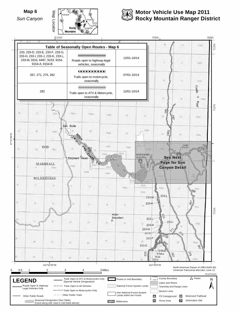
Map 6Sun Canyon
233, 233-D, 233-E, 233-F, 233-G, 233-H, 233-I, 233-J, 233-K, 233-L, 233-M, 3310, 6497, 9153, 9154,
9154-A, 9154-BRoads open to highway-legal
vehicles, seasonally
12/01-10/14
267, 271, 275, 282Trails open to motorcycle,
seasonally
07/01-10/14
282 Trails open to ATV & Motorcycle, seasonally
12/01-10/14
Table of Seasonally Open Routes - Map 6
Forest or Unit Boundary
National Forest System Lands
Non-National Forest SystemLands within the ForestOther Public Roads
County Boundary
Wilderness
Motor Vehicle Use Map 2011Rocky Mountain Ranger District

112°45'0"W
47°3
7'30
"N
R8WR9W
T21N
T22N
Motor Vehicle Use Map 2011Rocky Mountain Ranger District
North American Datum of 1983 (NAD 83)Universal Transverse Mercator, zone 12
FS-873-0115
±LEGEND
Seasonal Designation (See Table) {Used along with road or trail listed above}
Other Public Trails
Lakes and RiversTownship and Range Lines
Section Lines
FS Campground9
Picnic Area5
Motorized TrailheadE
Peaks)
] Information Site
98
654
2 3
1 7
£¤89
£¤93
£¤2
£¤287
WZ15
GreatFalls
Kalispell
Choteau
AugustaRockyMountains
Roads Open to Highway Legal Vehicles Only
0 1 2 30.5 Miles
Trails Open to All Vehicles
Trails Open to Motorcycles Only! ! ! ! !
Trails Open to ATV & Motorcycles Only(Special Vehicle Designation)
Map Locator
Map 7Sun Canyon
Detail
233, 233-K, 233-L, 233-MRoads open to highway-legal
vehicles, seasonally
12/01-10/14
267, 271, 277, 277.1 Trails open to motorcycle, seasonally
07/01-10/14
Table of Seasonally Open Routes - Map 7
Forest or Unit Boundary
National Forest System Lands
Non-National Forest SystemLands within the ForestOther Public Roads
County Boundary
Wilderness
112°45'0"W112°52'30"W
47°3
0'0"
N47
°22'
30"N
R8WR9WR10W
T19N
T20N
T21N
North American Datum of 1983 (NAD 83)Universal Transverse Mercator, zone 12
FS-873-0115
±LEGEND
Seasonal Designation (See Table) {Used along with road or trail listed above}
Other Public Trails
Lakes and RiversTownship and Range Lines
Section Lines
FS Campground9
Picnic Area5
Motorized TrailheadE
Peaks)
] Information Site
9
654
2 3
1 7
£¤89
£¤93
£¤2
£¤287
WZ15
GreatFalls
Kalispell
Choteau
AugustaRockyMountains
Roads Open to Highway Legal Vehicles Only
0 1 2 3 4 50.5 Miles
Trails Open to All Vehicles
Trails Open to Motorcycles Only! ! ! ! !
Trails Open to ATV & Motorcycles Only(Special Vehicle Designation)
Map Locator
Map 8Benchmark-Willow Creek
Forest or Unit Boundary
National Forest System Lands
Non-National Forest SystemLands within the ForestOther Public Roads
233, 233-C, 233-C1, 233-D, 233-E, 6497, 9154, 9154-A, 9154-B Roads open to highway-legal
vehicles, seasonally12/01-10/14
8801, 9209 Roads open to highway-legal vehicles, seasonally
07/01-10/14
204, 204.2, 236, 243, 256, 258, 258, 258.1, 267, 267, 275 Trails open to motorcycle,
seasonally07/01-10/14
282 Trails open to ATV & Motorcycle, seasonally
12/01-10/14
Table of Seasonally Open Routes - Map 8
County Boundary
Wilderness
Motor Vehicle Use Map 2011Rocky Mountain Ranger District

112°30'0"W
47°1
5'0"
N
R6WR7WR8W
T17N
T18N
T19N
Motor Vehicle Use Map 2011Rocky Mountain Ranger District
North American Datum of 1983 (NAD 83)Universal Transverse Mercator, zone 12
FS-873-0115
±LEGEND
Seasonal Designation (See Table) {Used along with road or trail listed above}
Other Public Trails
Lakes and RiversTownship and Range Lines
Section Lines
FS Campground9
Picnic Area5
Motorized TrailheadE
Peaks)
] Information Site
8
654
2 3
1 7
£¤89
£¤93
£¤2
£¤287
WZ15
GreatFalls
Kalispell
Choteau
AugustaRockyMountains
Roads Open to Highway Legal Vehicles Only
0 1 2 3 4 50.5 Miles
Trails Open to All Vehicles
Trails Open to Motorcycles Only! ! ! ! !
Trails Open to ATV & Motorcycles Only(Special Vehicle Designation)
Map Locator
Map 9Elk Creek-Dearborn
Forest or Unit Boundary
National Forest System Lands
Non-National Forest SystemLands within the ForestOther Public Roads
County Boundary
Wilderness